While a traditional focus of scholarly inquiry within the study of the world's ancient civilizations has been the study of temples and tombs, a substantial part of the archaeological record of the ancient world comprises the remains of peoples' households, and Mesoamerican archaeologists have long been on the leading edge of research on houses and households in the past. Houses and domestic spaces are places where people live, work, raise families, create memories, and communicate with others. They are an important nexus of diverse activities and interactions between household members and through which household members relate to their broader world—their local communities, regional polities, and broader societies. By focusing on the complexity of day-to-day life within the domestic domain and the diverse nature of its inhabitants, household studies have been important in demonstrating how people, their practices, and differences play a crucial role in the organization of past societies.
Household archaeology is now a well-established subfield within archaeology having emerged in the 1980s in large part due to research in Mesoamerican archaeology (for example, Flannery Reference Flannery1976; Webster and Gonlin Reference Webster and Gonlin1988; Wilk and Ashmore Reference Wilk and Ashmore1988; Wilk and Rathje Reference Wilk and Rathje1982). A relational view of society is emergent in household research in which households, communities, and society exist in a mutually constituting relationship, shaping and being shaped by one another (Hendon Reference Hendon2010; Hutson Reference Hutson2010; Robin Reference Robin2003, Reference Robin2013). When researchers explore the mired practices of daily life in households and communities it becomes clear that households were integral to society. Our research in household archaeology builds upon recent advances in this ever growing field of Mesoamerican studies that are enhancing our abilities to link levels of study from individual to households to community to state (Arnauld et al. Reference Arnauld, Michelet and Nondédéo2013; Christie Reference Christie2003; Douglass and Gonlin Reference Douglass and Gonlin2012; Gonlin and Lohse Reference Gonlin and Lohse2007; Hirth Reference Hirth2009; Inomata and Houston Reference Inomata and Houston2001; Joyce and Gillespie Reference Joyce and Gillespie2000; Lemonnier and Vannière Reference Lemonnier and Vannière2013; Lohse and Valdez Reference Lohse and Valdez2004; Manzanilla and Chapdelaine Reference Manzanilla and Chapdelaine2009; Santley and Hirth Reference Santley and Hirth1993; Sheets Reference Sheets2002; Yaeger Reference Yaeger and Smith2003; see also reviews of advances in Mesoamerican household archaeology by Carballo [Reference Carballo2011] and Robin [Reference Robin2003]).
This article explores households at the Maya farming community of Chan in Belize to demonstrate how household residents shaped their lives, history, and politics for a 2,000-year period from 800 b.c. to a.d. 1200 (Keller Reference Keller and Robin2012; Meierhoff et al. Reference Meierhoff, Golitko, Morris and Robin2012; Robin Reference Robin2013; Robin et al. Reference Robin, Meierhoff, Kosakowsky and Robin2012b). We focus on the households of Chan's leaders and the social, economic, political, and religious relationships between leading households and households across the farming community to show how novel forms of political practices arose through household interaction. Unremarkable in terms of community size or architecture, the farming community of Chan nonetheless flourished for twenty centuries while the fortunes of nearby major Maya civic-centers waxed and waned. The Chan Project research into leading households and their relationship with farming and crafting households reveals the ways in which household activities can shape politics, yielding new insights into the operation of power in ancient Maya society. Community leaders and households across the community developed community-focused ritual practices and heterarchical social and political strategies that were critical in the development of their community, were distinctive from the normative individual-focused political practices of the Classic Maya kings, and may have influenced the later development of more diverse political strategies in the Maya area in the Postclassic period (a.d. 900–1500).
HOUSEHOLDS AND POLITICS
Across the social sciences, the microscale of analysis has long been seen as an essential scale from which to study political organization (Bourdieu Reference Bourdieu1977; de Certeau Reference de Certeau1984; Scott Reference Scott1990). Politics is not a pre-existing entity, which hovers over the heads of members of a society; it is an ongoing process, involving the interactions of all members of society. Politics happen everyday as people—elites, commoners, and all those in-between—interact within their homes and communities (see also Hutson and Welch Reference Hutson and Welch2014; Joyce et al. Reference Joyce, Marc, Stacie, Jessica and Sarah2014).
Still, in political analyses there are often lingering assumptions which link the small scale and households with domestic life, and the large scale and public places with political life—a domestic-political dichotomy that household archaeologists and feminist scholars alike have shown to be most salient in the development of Western capitalist systems. Anthropological studies of the 1970s initially posited the universality of the contemporary Western division between “domestic/house (inside)/private/female/consumption/passive,” and the active public world of male politics and production (Rosaldo and Lamphere Reference Rosaldo and Lamphere1974). When household archaeology emerged within the discipline, initial critiques of the field suggested that political organization was inaccessible from household studies because “different processes occur at different social scales,” and that political structure could be gleaned only from “large-scale study (polities, polity networks, culture areas)” or “medium-scale study (corporate groups, communities, districts)” (de Montmollin Reference de Montmollin1988:65–71). Feminist scholars and household archaeologists alike were among the first to begin documenting how domestic and public/political spheres, as isolated social and spatial locations, were constructs of particular historical scenarios (Hendon Reference Hendon1996, Reference Hendon, Claassen and Joyce1997; Joyce Reference Joyce2000; MacCormack and Strathern Reference MacCormack and Strathern1980; Robin Reference Robin2002, Reference Robin2003; Tringham Reference Tringham, Gero and Conkey1991). For the Classic Maya, households were important places of “public” ritual performances and political meetings as well as locations for extra-household production (see Gonlin Reference Gonlin, Gonlin and Lohse2007, Reference Gonlin, Douglass and Gonlin2012; Hendon Reference Hendon, Claassen and Joyce1997; Hirth Reference Hirth2009; Inomata and Houston Reference Inomata and Houston2001; Inomata et al. Reference Inomata, Triadan, Ponciano, Pinto, Terry and Eberl2002; Robin Reference Robin2002, Reference Robin2003; Sheets Reference Sheets2002). Dichotomizing social domains such as political life and domestic life and equating them with particular spatial settings can lead to the omission or de-emphasis of important social interactions and social spaces which may be crucial for political analyses.
The monuments and inscriptions which have been the focus of traditional political analyses in archaeology provide insight into past public transcripts (sensu stricto James Scott Reference Scott1990), but it is archaeological studies of households—whether those of the humblest farmer or the most expansive royal court—that are exposing hidden transcripts (the lived experience of all members of society). In this way investigating households, of the rich and the poor, can provide us with a more nuanced understanding of the inner workings of past societies. Our analysis in this article takes daily life in households as its point of departure because peoples' day-to-day practices both give shape and meaning to the world and give them the ability to shape their world and make it meaningful. At the daily level of peoples' lived experiences, the ‘micro’ (self, interaction, and experience) and the ‘macro’ (institutions, power relations, and societies) intersect. As Michel de Certeau (Reference de Certeau1984) has asserted, everyday life can be an important locus of counter-normative action. It is political. It can lead to societal change as well as continuity. Social change happens throughout daily life as people accept and question, consciously or unconsciously, the meaning of existing social relations.
THE CHAN COMMUNITY
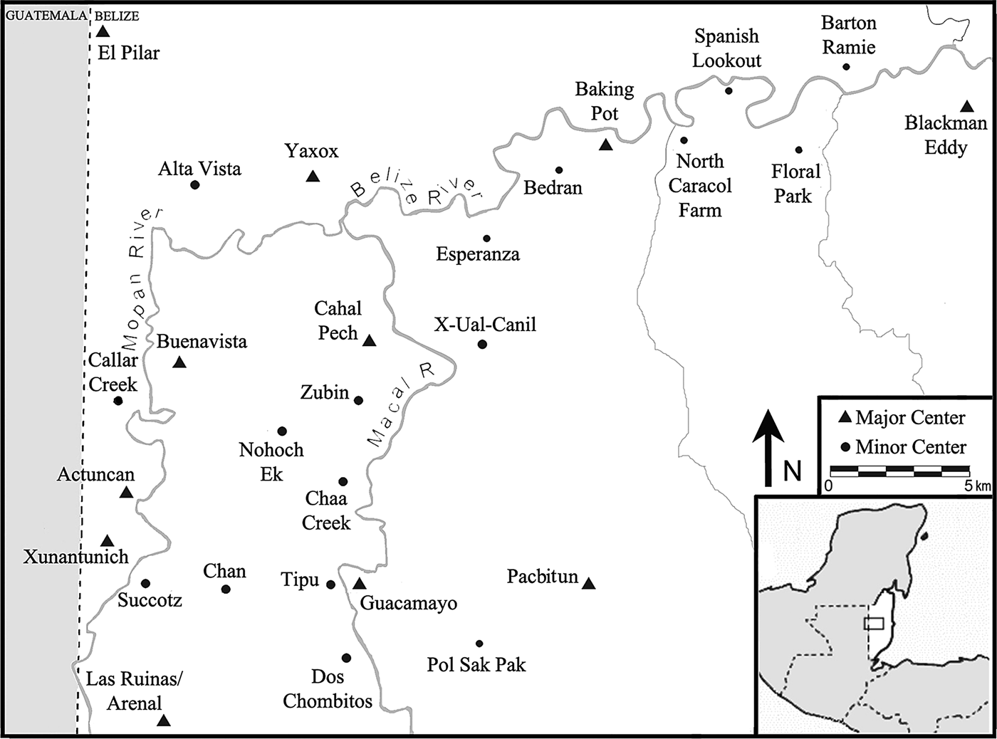
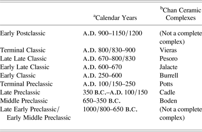
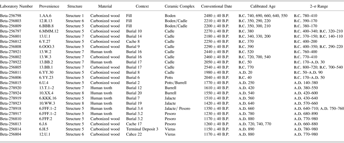
The Maya farming community of Chan is located in the upper Belize Valley region of west-central Belize, in an upland area between the Mopan and Macal branches of the Belize River (Figure 1). Across Chan's undulating upland terrain, its ancient inhabitants constructed a productive landscape of agricultural terraces surrounding a community center. This agricultural base supported Chan's 2,000-year occupation (800 b.c.–a.d. 1200), which spans the major periods of political change in Maya society—the Preclassic (1000/800 b.c.–a.d. 250), Classic (a.d. 250–900), and Postclassic (a.d. 900–1150/1200) periods (see Tables 1 and 2). The scale of the Chan community provides a window into the lives of people who lived in what was a prehistoric Maya agrarian community. Chan's deep chronology provides a means to examine diachronically how farmers' lives were embedded within and significant for the construction of broader regional political dynamics.
Map of the Belize River Valley and Maya area (inset) showing the Chan site. The major/minor center distinction illustrated in the map has its roots in the work of Bullard (Reference Bullard1960) and Willey et al. (Reference Willey, Bullard and Glass1955, Reference Willey, Bullard, Glass and Gifford1965), and has recently been applied in the Belize Valley by Driver and Garber (Reference Driver, Garber and Garber2004). Major centers are seats of power in a region. Minor centers are a variable group, smaller than major centers with many similar architectural components. Map by Elizabeth Schiffman.

Chronology chart detailing the ceramic complexes from the Chan site, Belize
a Calendar years are approximate based on correlation with other sites in the Maya lowlands. See Table 2 for radiocarbon dates.
b Chan ceramic complexes are named for geographical bodies of water in and around the Belize Valley.
Summary of radiocarbon dates from the Chan site, Belize
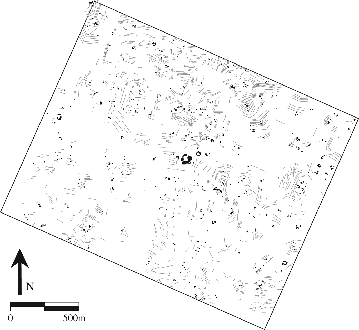
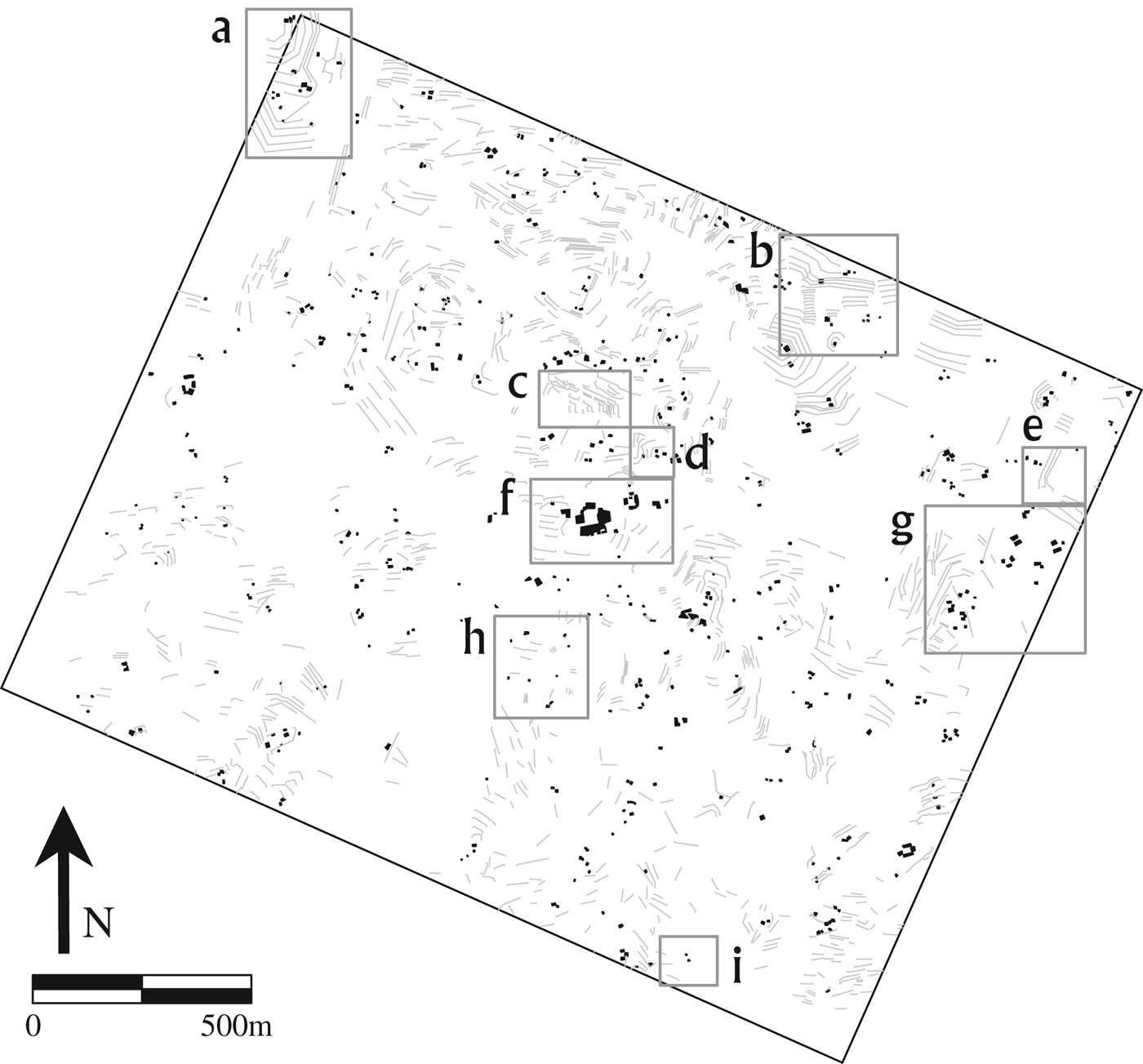
The Chan community consists of 274 households and 1,223 agricultural terraces surrounding a community center (Figure 2). The majority of Chan's residents were farmers (Wyatt Reference Wyatt and Robin2012). Some residents also produced chert bifaces (Hearth Reference Hearth and Robin2012), or limestone block (Kestle Reference Kestle and Robin2012), and leading residents were involved in the production and procurement of marine shell and obsidian objects (Keller Reference Keller and Robin2012; Meierhoff et al. Reference Meierhoff, Golitko, Morris and Robin2012). All of Chan's residents, from its humblest farmer to its community leader, lived in perishable buildings with thatch roofs constructed on stone substructures.
Topography, settlement, and agricultural terraces at Chan. Shown are settlement for all ceramic phases. Black squares are mounds, grey linear features are agricultural terraces. 10 m contour interval.
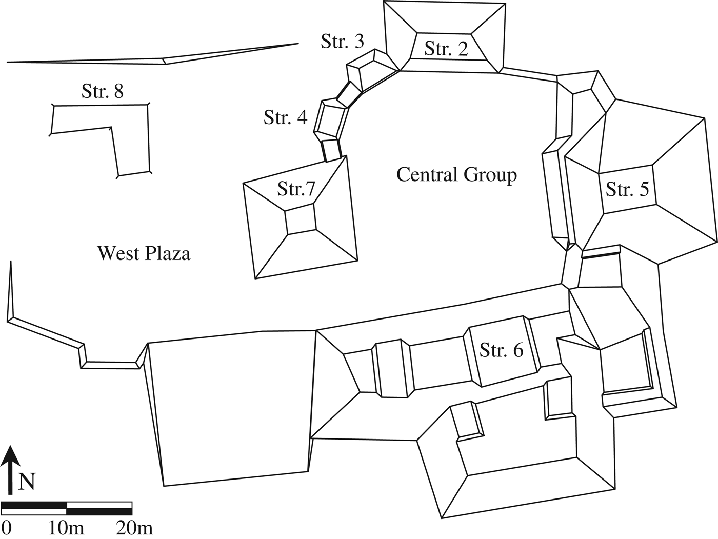
Chan's community center is located at the spatial and geographical center of the community on a local high point in the topography. It consists of two adjoining plazas (Figure 3). The Central Group is the largest architectural complex at Chan and was its main location for community-level political and ceremonial events, administration, and adjudication and houses a residence for Chan's leaders. The adjoining West Plaza is a largely open space used for public political and ritual events (Cap Reference Cap and Robin2012). On the east and west sides of the Central Group are the eastern and western shrines, Structures 5 and 7 (see Figure 3). The eastern shrine, Structure 5, is a tripartite structure. The central building of the triad is the tallest structure at Chan rising to a height of 5.6 m. The western shrine, Structure 7, is a single pyramidal structure. Paired east and west ritual structures in which the east structure is a tripartite construction and the west structure is a single pyramidal construction are commonly referred to as E-Groups (Aimers and Rice Reference Aimers and Rice2006). These distinctive architectural complexes were venues for ritual and ancestor veneration and possibly had astronomical functions (Aimers and Rice Reference Aimers and Rice2006; Aveni and Hartung Reference Aveni, Hartung and Aveni1989; Chase and Chase Reference Chase, Chase and Grube1995; Cohodas Reference Cohodas1980; Laporte and Fialko Reference Laporte, Fialko, Clancy and Harrison1990; Ricketson Reference Ricketson1928). On the north side of the Central Group, sits a residence of Chan's leaders, and two ancillary structures, Structures 2, 3, and 4. The administrative building, Structure 7, is located on the south side of the Central Group.
Chan's community center, the Central Group, and West Plaza. The Central Group structures illustrated and discussed in the text include: leading residence Structure 2, ancillary buildings Structures 3 and 4, east and west shrines/Structures 5 and 7, and administrative building Structure 6.
Excavations were undertaken at Chan between 2002 and 2009 by a team of more than 120 archaeologists, botanists, geologists, geographers, chemists, computer scientists, artists, students, workers, and volunteers from Belize, the United States, England, Canada, and China (Robin Reference Robin2012, Reference Robin2013). The project excavated a 10% sample of Chan's households (26 households) and associated agricultural terraces (Figure 4). This 10% sample represents the temporal, socioeconomic, and vocational variability in households at Chan. The project also excavated all ritual, residential, and administrative buildings at Chan's community center.
The Chan site showing excavation areas. (a) Operation 15 agricultural terrace and household excavations, (b) Operation 4 agricultural terrace and household excavations, (c) Operation 20 agricultural terrace excavations, (d) Operation 28 limestone quarry and household excavations, (e) Operation 18 agricultural terrace excavations, (f) Central Group, West Plaza, and leading family household excavations, (g) northeast group mid-level neighborhood excavations, (h) small farming family household excavations, (i) chert biface production household excavations.
Identifying the Chan Site and its Households
The Chan site was first identified by archaeologists in 1994, led by Wendy Ashmore, who were conducting settlement survey research in the region around the nearby polity capital of Xunantunich, which is located 4 km to the northwest of Chan (see Figure 1). The site had been long known to nearby residents and is named after its landowners—Dons Ismael and Derric Chan.
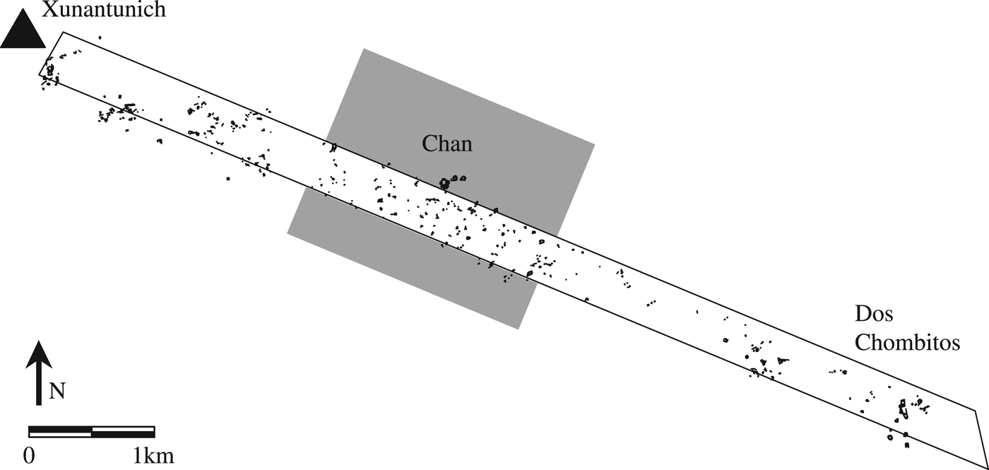
In order to explore interfluvial settlement, the Xunantunich settlement survey team extended a survey transect (Transect Archaeological 1) measuring 400 m wide and 8 km long, southeast from Xunantunich, which is situated along the Mopan branch of the Belize River, to the center of Dos Chombitos, situated along the Macal branch of the Belize River. This survey transect identified a settlement concentration and small site center, now known as Chan, equidistant (4 km) between Xunantunich and Dos Chombitos—a typical spacing distance for major and minor centers in the Belize Valley (see Driver and Garber Reference Driver, Garber and Garber2004). The Chan settlement cluster is both intuitively visible along the survey transect (Figure 5) and statistically identifiable based upon nearest neighbor and stem-and-leaf analyses (see VandenBosch in Ashmore et al. Reference Ashmore, Connell, Ehret, Gifford, Neff, VandenBosch and Leventhal1994).
Transect Archaeological 1 of the Xunantnich settlement survey showing the settlement cluster identified as Chan.
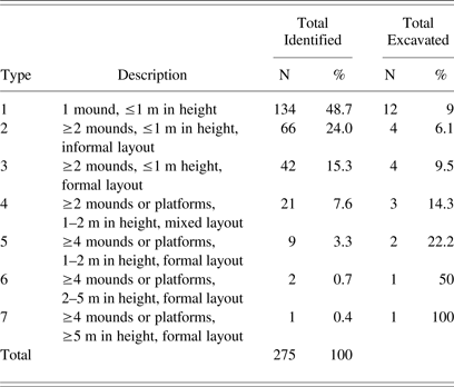
To begin assessing variability in Chan's settlement, investigators grouped mounds and classified those mound groups into a seven-tiered typology (Table 3). A “Mound Group” was defined as one or more mounds and associated archaeological features (excluding agricultural terraces) in which individual features within the group were less than 25 m distant from one another and all other, non-associated features were more than 25 m distant. The 25 m cutoff point was derived both from archaeological and ethnographic evidence for the extent of ancient and contemporary Maya house lots (Ashmore et al. Reference Ashmore, Connell, Ehret, Gifford, Neff, VandenBosch and Leventhal1994; Hanks Reference Hanks1990; Killion Reference Killion and Killion1992; Neff et al. Reference Neff, Robin, Schwartz, Morrison, Leventhal and Ashmore1995). Excavations at 10% of Chan's mound groups consistently indicated that the Mound Group was a good proxy for the ancient household unit, as discussed further below for Chan's leading households (also see Blackmore Reference Blackmore and Robin2012; Hearth Reference Hearth and Robin2012; Kestle Reference Kestle and Robin2012; Robin Reference Robin2002, Reference Robin2013). The mound group and adjacent agricultural terraces is the best proxy for the ancient farmstead unit (Wyatt Reference Wyatt and Robin2012).
Mound-Group typology for the Chan site, Belize
The seven-tiered Mound Group typology was initially developed by Jennifer Ehret on the Xunantunich Settlement Survey (Ashmore et al. Reference Ashmore, Connell, Ehret, Gifford, Neff, VandenBosch and Leventhal1994). It utilizes four criteria to classify mound groups including: (1) the number of mounds and platforms, (2) the height of mounds and platforms, (3) the formality of mound arrangement, and (4) the presence or absence of a focal group. The smallest and least formal Type 1 mound group consists of isolated mounds and associated features that are 1 m or less in height. The largest and most formal (Type 7) mound group consists of a platform group with four or more mounds, at least one of which is 5 m in height. Type 2 through 6 Mound Groups represent variation in terms of size and formality between these two extremes.
There is only one Type 7 Mound Group, Chan's Central Group, as discussed above (see Figure 3). Type 5 and 6 Mound Groups represent Chan's largest residentially focused platform groups. These are found either adjacent to the Central Group or dispersed across the community, located roughly 700 m to 1 km from the Central Group. This article will focus on the two Type 5 and 6 Mound Groups located adjacent to the Central Group, which have been identified as the residences of Chan's leaders. Figure 6 shows Chan's Type 7 Central Group (C-001) and the two adjacent Type 5 and 6 Mound Groups, C-002 and C-003. Blackmore (Reference Blackmore and Robin2012) identified that the larger residential platforms dispersed throughout the site are the households of head residents of subgroups or neighborhoods across Chan.
Chan's community center (Central Group and West Plaza) and adjacent leading residences (C-002 and C-003). Chan's largest leading residences, Structure 2 in the Central Group and Structure 17 in Group C-003, are marked.
Chan in a Belize Valley Context
The Belize Valley region where Chan is located was a peripheral and provincial part of the Maya world throughout most of its history (Garber Reference Garber2004; LeCount and Yaeger Reference LeCount and Yaeger2010; Leventhal and Ashmore Reference Leventhal, Ashmore and Garber2004). During the Preclassic, Early Classic, and early Late Classic periods (spanning 800 b.c.–a.d. 670), numerous mid-sized centers jockeyed for power across the region. These centers were organized as competitive peers, but none became a paramount center in the region (Ashmore Reference Ashmore, LeCount and Yaeger2010; Ball Reference Ball, Sabloff and Henderson1993; Ball and Taschek Reference Ball and Taschek1991; Houston et al. Reference Houston, Stuart, Taube and Kerr1992; Leventhal and Ashmore Reference Leventhal, Ashmore and Garber2004; Reents-Budet Reference Reents-Budet1994; Taschek and Ball Reference Taschek, Ball and Kerr1992). Many of these centers have been the subject of extensive archaeological research or are currently under investigation so their political histories are better understood. Among these mid-sized centers are Actuncan (LeCount Reference LeCount2004), Baking Pot (Audet and Awe Reference Audet and Awe2004), Blackman Eddy (Garber et al. Reference Garber, Brown, Awe, Hartman and Garber2004), Buenavista (Ball and Taschek Reference Ball, Taschek, Inomata and Houston2001; Yaeger et al. Reference Yaeger, Cap and Peuramaki-Brown2009), Cahal Pech (Awe Reference Awe1992), Guacamayo (Ashmore Reference Ashmore, LeCount and Yaeger2010), Las Ruinas (Ball and Taschek Reference Ball and Taschek1991), and Xunantunich (Leventhal and Ashmore Reference Leventhal, Ashmore and Garber2004) (see Figure 1 for the locations of these sites).
As documented by the Xunantunich Archaeological Project, at the end of the Late Classic period (a.d. 670–800/830) the western portion of the upper Belize Valley was unified under the short-lived and late flourishing Xunantunich polity capital (LeCount and Yaeger Reference LeCount and Yaeger2010; Leventhal and Ashmore Reference Leventhal, Ashmore and Garber2004). Located 4 km to the southeast of Xunantunich, Chan is located within a few hours walk from this major center and made up part of the late Late Classic Xunantunich polity. Xunantunich likely served as a regionally focal ritual venue for at least certain members of the Chan community. The late Late Classic was also the period of maximum population and agricultural expansion at Chan. That there would be some political interaction between Chan and the polity capital of Xunantunich is perhaps unquestionable given their proximity and settlement histories. The question that emerges is: What was the nature of their political relationships? Through time, Chan interacted with numerous Belize River valley centers in complex and overlapping relations of influence and authority. The late intrusion of the polity capital of Xunantunich into the long-lived history of Chan provides an opportunity to explore how a farming community might be transformed by its interaction with a polity capital and as well how a rising polity capital might have needed to accommodate to pre-existing contexts in farming communities. As we will develop in this article, across Chan's long history, residents developed resources and production, and complex webs of sociopolitical and economic relations with numerous centers within and beyond the Belize River valley. These resources, production, and sociopolitical relations, provided a constraint on the network of power that the rising Xunantunich polity capital hoped to dominate, and indeed ultimately achieved for only a short period of time.
LEADING RESIDENCES
Chan's leading residents occupied the northern structure (Structure 2) of the Central Group (C-001) and two residential plaza groups (C-002 and C-003), located adjacent to and east of the Central Group (see Figure 6).
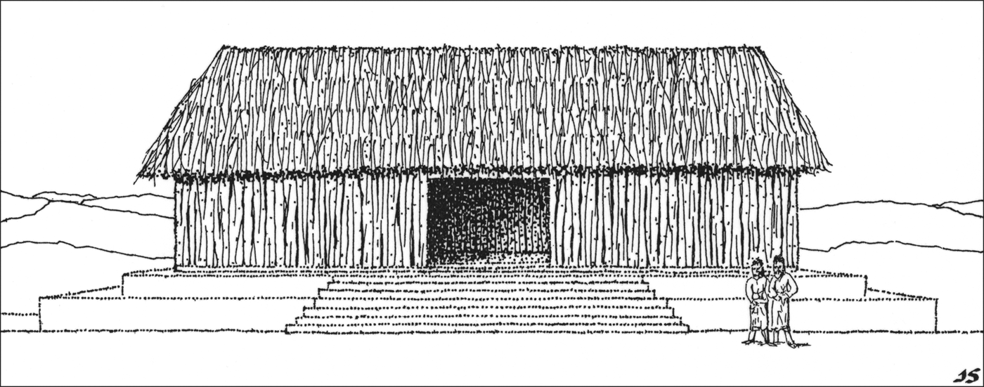
Structure 2 in the Central Group and Structure 17 in Group C-002 are the largest of the leading residences at Chan. Structure 2 is a bilevel stone platform 1.5 m in height with a front axial stairway that supported a pole and thatch house (Figure 7). A low (20 cm high) masonry bench took up most of the interior of the house. Structure 17 is a bilevel L-shaped stone platform, 1.5 m in height with a front axial stairway that supported a part masonry, part pole and thatch house. A 60 cm high masonry bench took up most of the interior of the house. Structure 17 is the only residential structure at Chan that had low (50 cm high) masonry foundation walls that supported fully perishable walls and a thatch roof. The high status of Chan's leading residents was not only visibly marked within the community through their relatively taller house platforms, it was also seen in their proximity to elaborate funerary rituals in the community center (Novotny Reference Novotny and Robin2012), certain exotic items such as non-Guatemalan obsidian (Meierhoff et al. Reference Meierhoff, Golitko, Morris and Robin2012), and their involvement in the production of exotic luxury items such as marine shell beads and obsidian blades (Keller Reference Keller and Robin2012; Meierhoff et al. Reference Meierhoff, Golitko, Morris and Robin2012). They also orchestrated community-level ceremonies, held large-scale feasts, and presided over the administrative and adjudicative functions of the community, as will be outlined in the sections below.
Reconstruction of a leading residence at Chan, Belize, dating to the Late Classic period, based on evidence from Central Group, Structure 2. The perishable superstructure is composed of pole and thatch that sits upon a stone platform. Illustration by Jack Scott.
Placement of Chan's Leading Residence in the Central Group
Beginning in the Middle Preclassic period (650–350 b.c.), Chan's residents manipulated cosmological principles in designing and building their community center (Robin et al. Reference Robin, Meierhoff, Kestle, Blackmore, Kosakowsky, Novotny and Robin2012a). Residents oriented the Central Group to the cardinal directions (see Figure 4). On the east and west sides of the plaza of the Central Group sit the two pyramidal structures of its central religious buildings and ancestral shrine (Structures 5 and 7), to the north sits the leading residence (Structure 2) and, to the south, its administrative building (Structure 6).
As Ashmore (Reference Ashmore1991) documents for larger civic centers across the Maya area, in constructing their cities and placing particular types of buildings in specific cardinal directions, Maya royalty referenced cosmological understandings to make powerful political and ideological statements through the architecture of a city (see also Ashmore and Sabloff Reference Ashmore and Sabloff2002; Hutson and Welch Reference Hutson and Welch2014). East and west within a city spatially mark the path of the sun and the location of the rising and the setting of the sun as seen on the horizon. Maya royalty often marked the east and west sides of plazas with ritual structures that commemorated these significant natural cycles as well as agricultural cycles. Along the sun's daily path, north (up) marks the sun's height at midday, associating north with the heavens and a position of supreme power. South (down) is associated with a worldly and underworldly position as the sun passes through the underworld at night. Across the Maya area, leaders of the largest Maya cities claimed the powerful north location for the construction of their residences or monuments commemorating their power, to make a vivid and visual statement about that power. The worldly affairs of administrative buildings are often found in southern locations.
At Chan, in the Middle Preclassic period, the north point of the Central Group was marked by a cache containing a single blue-green teardrop-shaped jade adorno. This small piece of jade marked the center of the north residence (Structure 2), which was at that time a 25 cm-high stone structure. While the north residence grew in size through time, ultimately rising to a height of 1.5 m, the position of the jade adorno remained the center point of the structure across its subsequent history.
Chan is certainly not unique among smaller centers in its manipulation of cosmological principles in site planning. Hutson and Welch (Reference Hutson and Welch2014) also demonstrate how the residents of Kancab, located in the northern Maya lowlands, constructed cardinally-directed causeways to focus their community around a sacred quadripartite and quincunx pattern. From small Maya centers such as Chan and others, to the largest royal centers, residents employed similar directional principles and spatial layouts to define community centers and invest salient social meanings in spaces to define Maya places. When similar social ideals appear at small and large sites, some archaeologists tend to argue that the small site is mimicking or emulating the ideas developed at the larger site. But the historical depth of the planning principles employed in the construction and reconstruction of Chan's community center shows that many of the ideas that later in time became part of a Maya noble and royal ideology and political strategy were, in fact, initially conceived by farming communities.
Houses
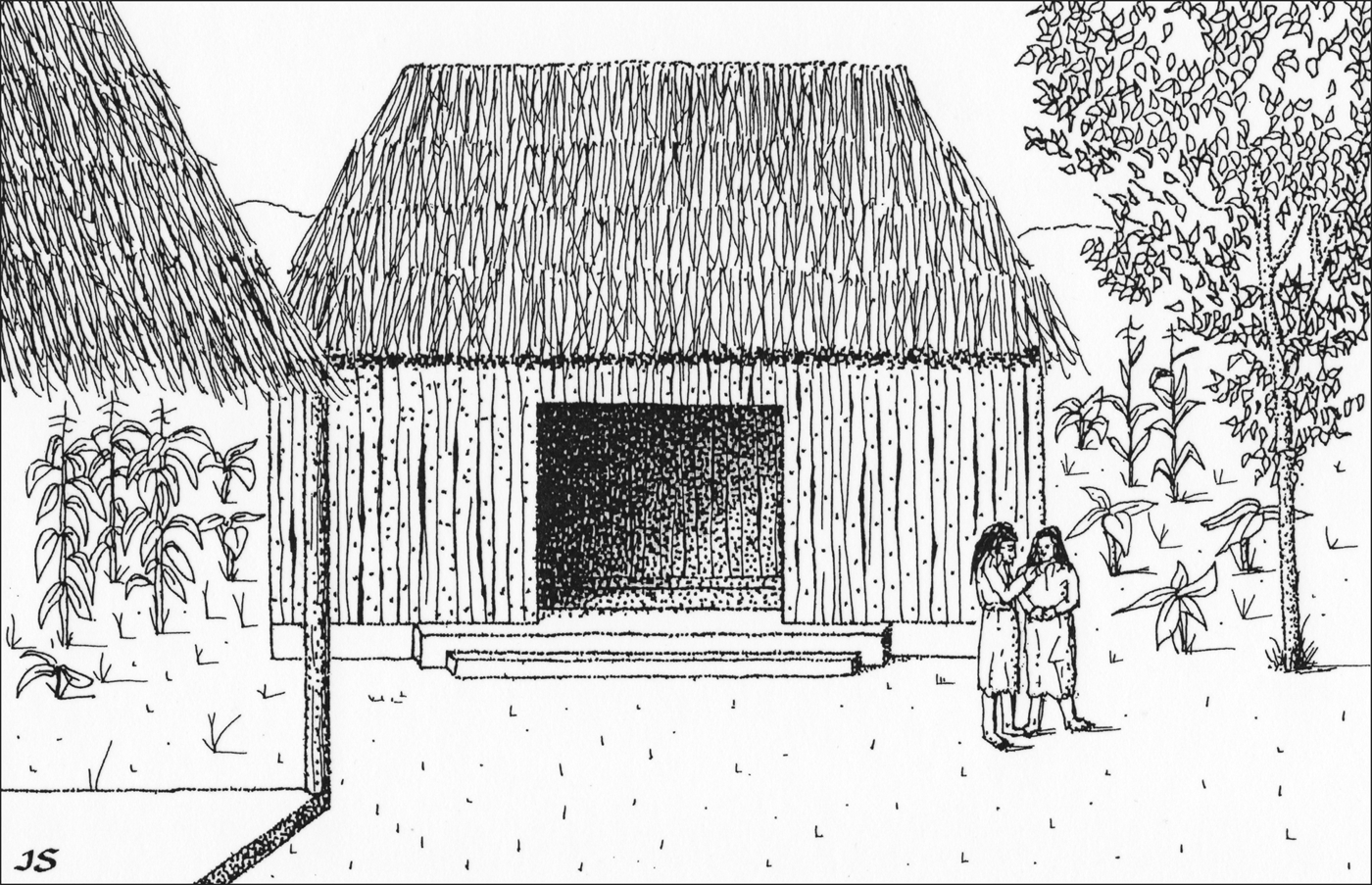
Although Structure 2 in the Central Group and Mound Groups C-002 and C-003 were among Chan's largest residences, with stone basal structures measuring over 1 m tall, perishable houses with thatch roofs surmounted these structures (see Figure 7). As mentioned previously, only one residence, Structure 17, had low (50 cm high) masonry foundation walls that supported full perishable walls. Chan's leaders, like its other residents, lived in perishable houses (Figure 8).
Reconstruction of a farming residence at Chan, Belize, dating to the Late Classic period, based on evidence from household CN1. The perishable superstructure is composed of pole and thatch that sits upon a stone platform. Illustration by Jack Scott.
The perishable house construction of all residences at Chan at first seems unremarkable. It could perhaps be used simply to classify Chan's residents as situated at the lower end of the social spectrum in Maya society. But upon reflection, it tells us a great deal more about social life in the community. The variable elevation of stone house platforms across the community was a visible way that residents perceived and signaled to one another, on a daily basis, social differences within the community. But equally visible each day were the social commonalities among residents that cross-cut these differences: every resident from community leader to farmer, across 274 households in a 3.2 km2 area, lived in a perishable house with a thatch roof. This point becomes even more striking in comparing Chan to neighboring communities.
Across the Maya area housing ranged in type from perishable constructions, such as those seen at Chan, to residences that have low or partial stone foundation walls that supported higher perishable walls and thatch roofs (like Structure 17 at Chan), residences that had full stone walls and thatch roofs and, finally, to the most elaborate residences completely made of stone, with stone walls and corbel vaulted roofs. That a full range of housing types is found at large civic centers across the Maya area, but not at Chan, perhaps goes without saying. But even when comparing Chan to other smaller communities in the Belize Valley area, one sees a greater variety of housing types at other communities of comparable size.
The San Lorenzo hamlet (Yaeger Reference Yaeger, Canuto and Yaeger2000, Reference Yaeger and Smith2003), located 4 km from Chan, consists of 20 household groups—a fraction of the number of household groups at Chan (see Figure 1; hamlets are not shown here, but San Lorenzo is located just across the Mopan River from Xunantunich). San Lorenzo's smallest residences, like Chan's, were perishable constructions on low stone platforms, but larger residences had low or partial stone foundation walls that supported higher perishable walls, or had full stone walls, and at least one residence had a corbel vaulted roof. Despite being a smaller settlement, there was greater variability and more stratification in terms of housing at San Lorenzo. The Chaa Creek minor centers, CC1 (Stela Group) and CC18 (Tunchilen Group), located 5 km from Chan, are comparable to, but smaller than, Chan's Central Group and are surrounded by smaller settlement areas (Connell Reference Connell, Iannone and Connell2003, Reference Connell, LeCount and Yaeger2010) (see Figure 1). Leaders of the Chaa Creek minor centers lived in corbel vaulted residences in the Late Classic period.
Given these comparative data, it now seems remarkable that across 274 households in a 3.2 km2 area at Chan, all residents lived in perishable houses. As much as this distinction is striking from a contemporary archaeological perspective, it also would have been striking to residents of Chan and various nearby communities. At Chan, leader to humble farmer lived in a perishable residence and this lesser degree of social stratification in housing types would have been visible across the community.
Craft Specialization and Luxury Items
Adjacent to Structure 2 in the Central Group are two low ancillary structures, Structures 3 and 4, consisting of low stone platforms that rose to 65 and 70 cm in height, respectively (see Figure 3). Craft production was one likely function to have taken place at Structures 3 and 4. Excavators identified obsidian debitage related to core maintenance activities suggesting low-intensity pressure blade production in a fill episode in Structure 3 dating to the Early Classic period, and a fill episode in Structure 4 dating to the Late Preclassic period (350 b.c.–a.d. 100/150) (Meierhoff et al. Reference Meierhoff, Golitko, Morris and Robin2012). Structures 3 and 4 are the only places where excavators identified obsidian blade production debris at Chan. This distribution suggests that Chan's leading residents either possessed the skills for obsidian blade production or associated themselves with attached specialists or itinerant specialists who may have worked out of these ancillary structures (Meierhoff et al. Reference Meierhoff, Golitko, Morris and Robin2012).
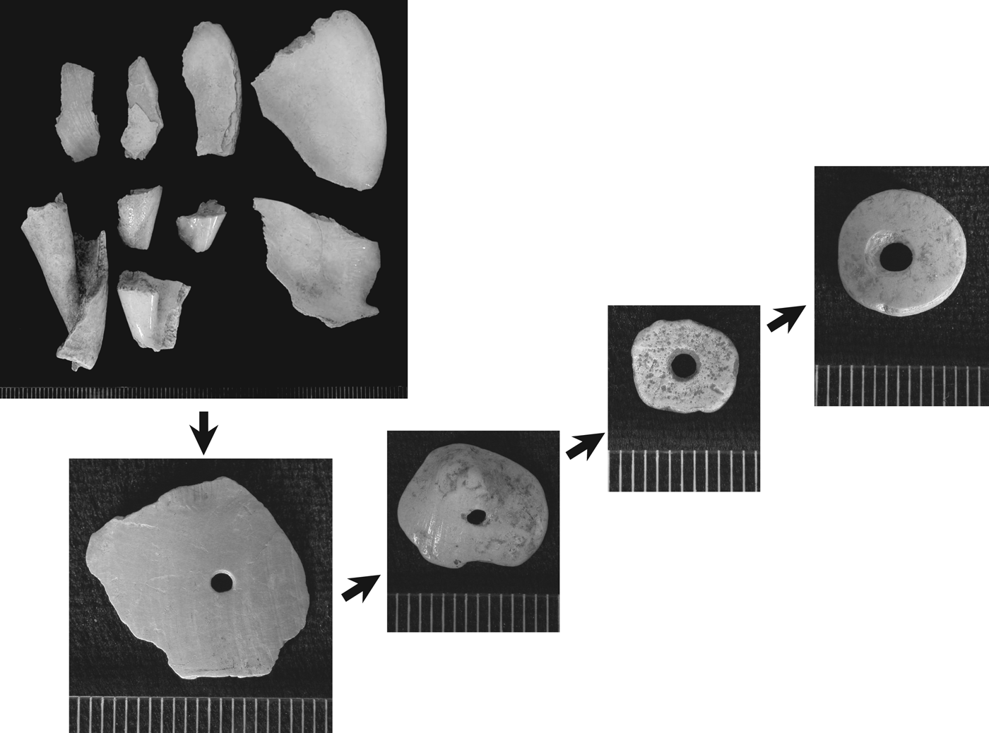
Chan's leaders were involved in small-scale Strombus shell ornament production in the Middle to Terminal Preclassic periods (650 b.c.–a.d. 250). Marine shell working detritus from this manufacture was identified in fill episodes in Structure 2, Structure 3, Structure 7, the Central Plaza, and Structure 8 in the West Plaza. Preclassic shell workers produced relatively simple ornaments such as perforated shell fragments and disk beads for distribution within the community (Figure 9). By the Late Classic period local shell working diminished, and Chan's leaders were distributing finely worked shell items produced elsewhere, including countersunk disks, rosettes, unperforated saucers, and an unusual toggle-bead type all made of conch (Keller Reference Keller and Robin2012).
Illustrating the sequence of Strombus sp. shell bead production (scale in millimeters). Photos by Angela Keller.
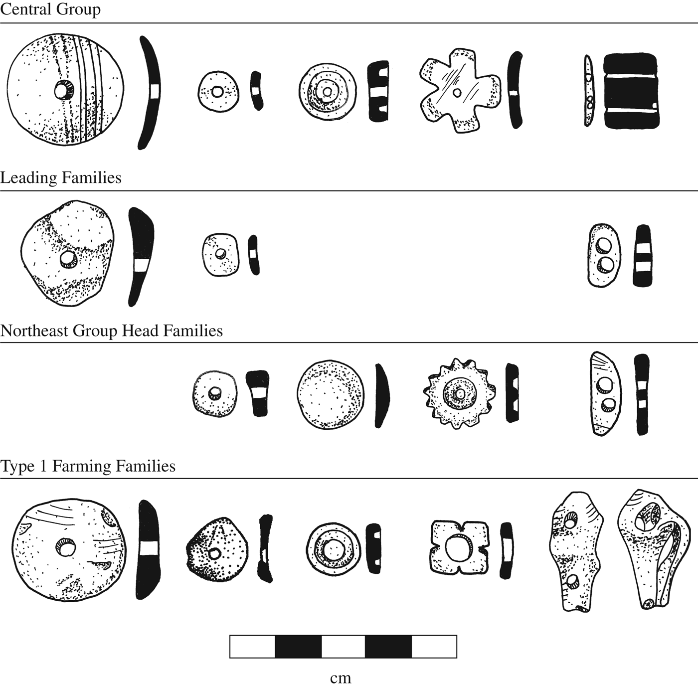
Leaders were the only residents at Chan to be involved in the manufacture of exotic items, though residents elsewhere in the community were involved in types of craft production that involved local materials such as the production of chert bifaces or limestone block (Hearth Reference Hearth and Robin2012; Kestle Reference Kestle and Robin2012). Chan's leaders had quantitatively more luxury items such as jade, shell, and obsidian than other residents across the community, again marking their distinction in visible ways (Blackmore Reference Blackmore2011, Reference Blackmore and Robin2012; Keller Reference Keller and Robin2012; Meierhoff et al. Reference Meierhoff, Golitko, Morris and Robin2012). Still, all residents across the community had access to luxury items of comparable quality and style in their homes and for their bodily adornment, and this would have re-enforced commonalities across the community. Comparable access to similar marine shell ornament types of similar quality and obsidian blades from the three primary Guatemalan sources, Ixtepeque, San Martin Jilotepeque, and El Chayal (Keller Reference Keller and Robin2012; Meierhoff et al. Reference Meierhoff, Golitko, Morris and Robin2012), are two examples (Figure 10). As seen in housing, while the larger quantity of luxury items leading residents possessed indicates their high status, the comparability of the types of luxury items possessed by all of Chan's residents suggests a heterarchical arrangement of difference in terms of access to luxury goods. Again, this distribution differs from that seen at neighboring small communities. At San Lorenzo higher-status residents had access to more elaborate shell ornament types than lower status residents (Yaeger and Robin Reference Yaeger, Robin, Lohse and Valdez2004). At Chaa Creek community leaders amassed locally unprecedented wealth including greenstone beads, polychrome vessels, chert and obsidian eccentrics, shell pendants, and high-quality tools and ground stone (Connell Reference Connell, Iannone and Connell2003). At Chan, all residents lived in perishable houses, goods were more equitably distributed, and social stratification was less pronounced.
Examples of shell ornaments distributed across the Chan community. Illustrations by Carmen Ting.
Chan's leaders had access to a single exotic item not found elsewhere in the community: non-Guatemalan obsidian (from Pachuca and Paredon, in Mexico, and La Esperanza, in Honduras; these sources are located anywhere from 320 to 1,070 km from Chan). One hundred percent of the obsidian from Chan was examined using a portable X-Ray fluorescence (XRF) device at the Field Museum of Natural History to determine geological sources for the entire obsidian assemblage (Meierhoff et al. Reference Meierhoff, Golitko, Morris and Robin2012). The four pieces of non-Guatemalan obsidian date to the late Late Classic and Terminal Classic periods (a.d. 670–900). Because they do not occur in the assemblages of Chan's leaders prior to the late Late Classic period (when Xunantunich rose to power) and are from the most distant location of any items found at Chan, one plausible interpretation for the presence of these items is that they might be political gifts from the more regionally connected rulers at Xunantunich, who may have had access to more distant trade networks than residents at Chan. But, there is another plausible explanation: Chan's leaders had played a role in obsidian production and exchange at Chan since the Preclassic period. They may have built upon this historical role to expand their regional networks in relation to obsidian in the late Late Classic period. Thus leaders' long term relationships to distant places, rather than their emerging relationship with the Xunantunich polity capital, may account for the presence of non-Guatemalan obsidian at Chan.
Understanding what political-economic connections allowed Chan's leaders to procure distant non-Guatemalan obsidian requires the sourcing of obsidian at Xunantunich and other major centers in the Belize Valley, which unfortunately has not been undertaken to date. One of the pieces of non-Guatemalan obsidian found at Chan comes from the Pachuca source (located 1,070 km distant from Chan, the most distant item found at the site). Pachuca obsidian has a distinctive green color that allows it to be sourced visually. Thus it is possible to explore how at least this one exotic item arrived at Chan. Kindon and Connell (Reference Kindon and Connell1999) visually sourced the obsidian from the Xunantunich Archaeological Project collections, which include obsidian from Xunantunich and nearby smaller settlements. No Pachuca obsidian was identified at Xunantunich. Other than the Chan example, the only Pachuca obsidian in the Xunantunich area comes from the minor center of Chaa Creek (three pieces) and the hamlet of San Lorenzo (one piece). Researchers have also visually identified Pachuca obsidian from recent excavations at the nearby major centers of Buenavista and Cahal Pech, located in the Belize Valley (Jaime Awe, personal communication 2011; Jason Yaeger, personal communication 2011). Given that Xunantunich's rulers did not possess Pachuca obsidian, they likely did not have any special claim on the distant trade networks that brought Pachuca obsidian into the Belize Valley. Conversely, major Belize Valley centers such as Buenavista and Cahal Pech, which were not as powerful as Xunantunich in the late Late Classic period, did have access to Pachuca obsidian, as did the residents of Chan. It is impossible to know exactly how Chan's leaders acquired Pachuca obsidian. (Through long-standing political economic relationships with Buenavista, or Cahal Pech, or some other center?) Nevertheless, it is clear that it was not through political gifting from Xunantunich. Plausibly, the political and economic means through which Chan's leaders acquired Pachuca obsidian in the Late and Terminal Classic periods were a continuation of connections they had established earlier with other political centers with whom they were involved. Chan's long-term political and economic ties with a range of political centers in the Belize Valley, and even beyond the valley, seem to have provided some of the resources that allowed Chan's leaders to develop some form of political constraint on the networks of power that the late rising Xunantunich polity capital hoped to develop, and ultimately dominated, for only a short period of time.
Feasting and Festivals
Two lines of evidence suggest that Chan's leaders hosted feasts as part of their community building festivals: (1) larger quantities of ceramics from ancillary Structures 3 and 4, and (2) the deposition of an enormous amount of jute shells (freshwater snails) between the Central Group and the leading residences at C-002.
Excavators identified the highest quantities of ceramics on the surfaces of ancillary structures (Structures 3 and 4) at Chan. Kosakowsky's (Reference Kosakowsky and Robin2007) ceramic analysis also identified greater amounts of ceramics in the fill from Structures 3 and 4 than from any other structures in the Central Group. The higher quantity of ceramics at these ancillary structures suggests that at least one function of these buildings, in addition to craft work, was the preparation of food—meals for leading residents and, perhaps, festival foods for the feasts that accompanied ceremonies hosted by leaders in the Central Group.
Between the Central Group and the leading residences at C-002 are two midden areas largely comprised of jute shells, referred to as the “jute midden” (see Figure 6). On the basis of Kosakowsky's (Reference Kosakowsky and Robin2007) ceramic analysis, the jutes themselves were likely consumed in the Middle to Late Preclassic period, as the dense jute deposit is interspersed with redeposited Middle and Late Preclassic sherds. In the Late Classic period the “jute midden” was likely moved and redeposited at its current location. The “jute midden” contained 46,000 shells per m3, equaling roughly 2.7 million jute shells in total (Pachychilus indorium [96%], Pachychilus glaphyrus [2%], and Pachychilus largillierti [2%]). Keller (Reference Keller and Robin2012) likens the deposit to a vast ritual sea of jutes, drawing upon archaeological and ethnographic findings about their ritual use and symbolic meaning (see, for example, Cap Reference Cap and Robin2012; Halperin et al. Reference Halperin, Garza, Prufer and Brady2003; Jamison Reference Jamison and Leventhal1992). Using Healy and colleagues' (Reference Healy, Wright and Emery1990) nutritional data, the Chan jute midden contains roughly 23,000 meals of 500 calories each, or possibly the remains of 115 gatherings of 200 people—this size gathering would include the majority of Chan's residents in the Late Preclassic period when the jutes were consumed (Keller Reference Keller and Robin2012). Estimates for Chan's Late Preclassic population based on settlement survey and surface collection ceramic data range from 195 to 330 people (Robin et al. Reference Robin, Wyatt, Kosakowsky, Juarez, Kalosky, Enterkin and Robin2012c).
For each major period of occupation we developed minimum and maximum population estimates drawing upon a range of published procedures in Mesoamerican archaeology (see, for example, Culbert and Rice Reference Culbert and Rice1990). Population was estimated for an area with a 1 km radius around the Central Group—corresponding to the intuitively and statistically identifiable settlement concentration around that group. This area includes the core of the community and surrounding subgroups. In calculating population estimates, several variables need to be considered: number of structures, percentage of structures determined to be residential, percentage of structures dated to the phase in question, percentage of structures inhabited contemporaneously, and number of individuals living in each structure. Depending on how one estimates any one of these variables, the projected population estimate can vary widely. Given that 562 mounds were identified across the 3.2 km2 Chan survey area, we estimate that there were 552 mounds within a 1 km radius of the Central Group. Using excavation data to estimate how many mounds were residential, we estimate that 436 mounds were residential. To calculate a minimum population estimate, we used the following equation: 436 residential mounds × percent dated to phase × 75% contemporaneity × 4 persons/residence. For our maximum estimate we used 436 residential mounds × percent dated to phase × 90% contemporaneity × 5.6 persons/residence. A more extensive discussion of our population estimating procedures can be found in Robin et al. (Reference Robin, Wyatt, Kosakowsky, Juarez, Kalosky, Enterkin and Robin2012c:Note 2). Population estimates allow us not only to compare populations at Chan through time, but also to compare populations at Chan to other Maya communities where similar estimating procedures have been used. We see generating ancient population estimates not as a means of getting at absolute population levels, but as a means of identifying relative population levels for comparative purposes.
The sharing of food was a means through which Chan's leaders built community and asserted their authority. The size of the Central and West Plazas also suggests that the feasts and festivals hosted by Chan's leaders were community-wide events. At the height of its construction in the late Late Classic period, the Central Plaza had an area of 1,154 m2, and the West Plaza had an area of 1,928 m2 (including its broad south stair). Drawing on ethnographic research on the number of people who can be accommodated in open spaces during public events, Inomata (Reference Inomata2006 [following Moore Reference Moore1996]) estimates that participants attending events in Maya plazas would require between .46 and 3.6 m2/person of plaza space. The lower number corresponds to a tightly packed event and the higher number corresponds to an event in which participants had substantial space to move around. Using these numbers to gauge a minimum and maximum number of people that could participate in events in Chan's plazas in the late Late Classic period, we suggest that between 857 and 6,700 people could have attended events there. The larger of these numbers is significantly more than the number of residents at Chan at its population peak, and the smaller of these numbers would have still included a broad spectrum of residents from across the community. Using settlement survey and ceramic surface collection data, estimates for Chan's late Late Classic population range from 994 to 1,670 people (Robin et al. Reference Robin, Wyatt, Kosakowsky, Juarez, Kalosky, Enterkin and Robin2012c). Ritual events sponsored by Chan's leaders at its community center can be correctly referred to as community-wide festivals that involved the broad membership of the community. The community-wide nature of festivals at Chan diverges from what Inomata (Reference Inomata2006:811–814) identifies at the largest of Maya ceremonial centers, such as Tikal, where plazas could only hold a select portion of community residents. Instead, it is comparable to what he (Inomata Reference Inomata2006) finds at small royal centers such as Aguateca, where, as at Chan, all residents of a community could have attended events in its central plazas.
The simultaneous presence of the entire Chan populace for community-wide festivals furthers our understanding of the power of these events in building community. Festivals were times when community members came into face-to-face contact with each other. Residents experienced together the convening with ancestors, the burning of incense, and the deposition of sacred objects that consecrated community. All of these phenomena would have given a physical and experiential reality to the Chan community.
Community-wide rituals would also have embodied the divisions and competition within the community (Blackmore Reference Blackmore2011, Reference Blackmore and Robin2012; Cap Reference Cap and Robin2012). Social differences among community members would have been as visible at these events—through what people wore and where they were able to stand to view events—as the shared community concept that they were constructing. As well, hidden in the crowded space of a public event in the Central Plazas, residents may have been able to find the privacy to voice concern or dissent (see Scott Reference Scott1990).
Across its 2,000-year history Chan's community center was a place where residents came together for community-wide ceremony and political events. While these were not daily, they were neither devoid of, nor detached from, the quotidian. Residents and ritual practitioners typically chose objects that they used in daily domestic life, not a specialized set of objects produced solely for ritual use, for placement in caches, burials, and terminal deposits. The ceramic vessels placed in ritual deposits, the most numerous items they placed in these deposits, were previously used items. They were people's possessions and containers for food and other items (Kosakowsky et al. Reference Kosakowsky, Novotny, Keller, Hearth, Ting and Robin2012). Even the luxury items ritual practitioners incorporated into deposits show evidence of use. They included shell detritus from marine shell bead production in ritual deposits in the Preclassic period (Keller Reference Keller and Robin2012). Jade objects, beads, celts, and other polished pieces were used, broken, or formerly strung. There were a few items that appear to have been specially produced for ritual use, such as a unique 38 cm-long honey brown-colored chert blade from Northern Belize and eccentric chert objects (crescents, serpents, and celestial forms) that do not show signs of use, and are not found in domestic, nonritual inventories. But, most of the objects that ritual practitioners interred in ritual deposits were items people had used in daily life.
Because the objects ritual practitioners incorporated into ritual deposits were those residents used in daily life and could typically be found in domestic inventories, ritual and everyday life were linked at Chan. Residents' concerns for the sacred and supernatural were tied to, not separate from, the experiences of everyday life, through the incorporation of ordinary objects in ritual. As community members gathered on special occasions to observe even the largest of community-wide ritual events at Chan's community center, they experienced not only a sacrosanct periodic event, but through the manipulation of daily objects in these events, recognized the way the sacred and the meaning of special events was deeply tied to the conditions of their daily lives.
Burial
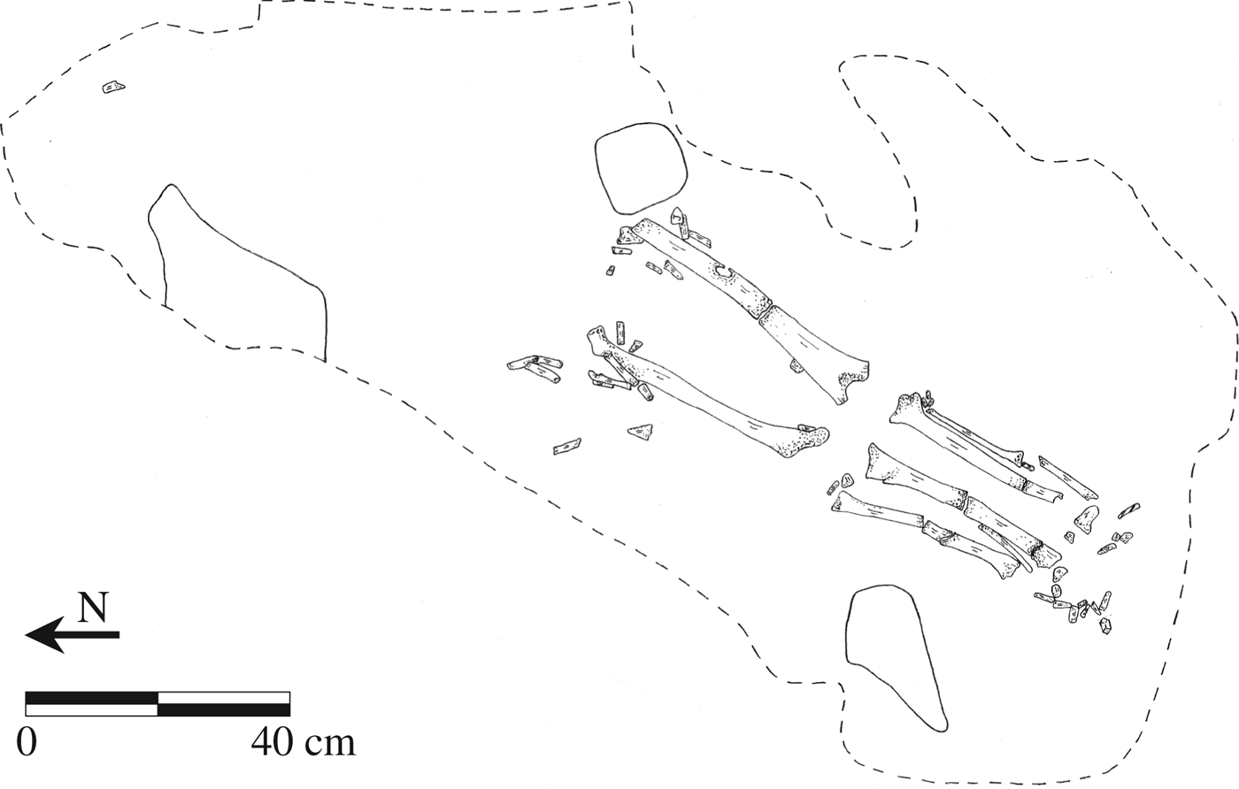
In the Middle Preclassic period, a single ancestor burial was identified in the Central Plaza, presumably one of Chan's leading residents. This individual, an adult aged 20–24 of unknown sex (Burial 1), was placed in a shallow grave cut into the underlying limestone bedrock (Novotny Reference Novotny and Robin2012) (Figure 11). This grave was reentered for centuries across the Middle Preclassic and Late Preclassic periods (650 b.c.–a.d. 100/150). At each reentry the people visiting the grave deposited fragments of human bone, serpentine, jade, shell, and slate above the grave. These objects were either objects people had originally placed with the deceased and later removed and replaced during the reentries, or they were objects deposited later, at the time of the reentry to commemorate visitation of the interred individual. Regardless, residents remembered and revered the death and burial of this individual for generations and, in fact, centuries, interring them with the most offerings of any ancestor or person buried at Chan, and thus initiating a practice of remembering and revisiting ancestral burials across time at Chan.
Plan map of Burial 1, Chan, Belize, from the Central Plaza of the Central Group. Drawing by Carmen Ting.
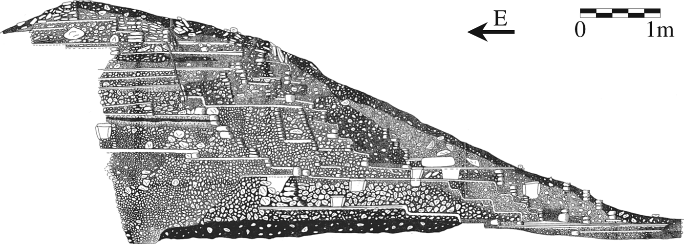
Beginning in the Late Preclassic and continuing into the Terminal Classic period, Chan's eastern and western shrines (Structures 5 and 7) became the community's primary location for ancestral burials (Figure 12). Adults and children, men and women, were among the 20 individuals buried in 14 graves that were excavated in these structures (Novotny Reference Novotny and Robin2012).
Profile of the central structure (Structure 5, center) of the eastern tripartite shrine at the Central Group, Chan, Belize. Profile shows stratigraphy and voids indicate the location of graves. Illustration by Nasario Puc.
Focus on the individual ancestor as a part of ritual and political process was most marked at Chan in the Preclassic period, when ritual practitioners interred their dead in the Central Plaza and the eastern and western shrines with more grave offerings than their Classic period counterparts (Novotny Reference Novotny and Robin2012). Residents buried curated Middle Preclassic figurines, each with unique facial characteristics that may represent actual portraiture, with Late Preclassic ancestors, possibly to link the deceased with founding members of Chan (Kosakowsky et al. Reference Kosakowsky, Novotny, Keller, Hearth, Ting and Robin2012). In terms of shell ornamentation, only two shrine burials, Late Preclassic Burial 10 and Terminal Preclassic Burial 2, were accompanied by shell ornaments that marked individual identity (Keller Reference Keller and Robin2012).
In the Classic period, burial and caching in the shrines shifted from a focus on individual ancestors to a focus on the community as a whole (Robin et al. Reference Robin, Wyatt, Kosakowsky, Juarez, Kalosky, Enterkin and Robin2012c). This change is evidenced by a shift from burying ceramics and other material objects with individual ancestors to burying these items in caches and terminal deposits, foregrounding the community, rather than the specific ancestor, as the focus of ritual activity (Kosakowsky et al. Reference Kosakowsky, Novotny, Keller, Hearth, Ting and Robin2012), and an increase in the number of multiple (over single) interment ancestor burials (Novotny Reference Novotny and Robin2012). Changes in Classic period rituals in the eastern and western shrines also indicate a heightened focus on highlighting the community as a whole in ritual practices.
CONCLUSION
The high status of Chan's leaders who lived in Structure 2 in the Central Group and adjacent residential groups C-002 and C-003, is defined by the size and centrality of their residences, their unique proximity to elaborate funerary rituals, to non-Guatemalan obsidian, and by their involvement in the production of nonlocal luxury items. Although there were clear differences between leaders and other community members, there is no evidence of an extreme system of social stratification at Chan. Leaders, like other residents, lived in perishable houses. While they had quantitatively more luxury items than other residents, they did not have a qualitatively different range of luxury items, with the exception of non-Guatemalan obsidian.
There were other important shared qualities of life across status groups at Chan. Novotny's (Reference Novotny and Robin2012) osteological analysis suggests that levels of health remained comparable across the community's 2,000-year history. The consistent presence of a low degree of biological stress in the skeletal population indicates the persistent good health of the community. This pattern contrasts with evidence from major centers in the Belize Valley and across the Maya area, which indicate that health declined across time in the Classic period (Haviland Reference Haviland1967; Healy Reference Healy2004; Whittington and Reed Reference Whittington and Reed1997).
In terms of their house construction efforts—one of the most visible statements a resident can make in their community—Chan's residents could be classified at the lower end of the social spectrum in Maya society. Residents certainly had less privilege and possessions than society's power brokers. But when we look deeper into the residents' everyday lives, there is a remarkable high quality of possessions and personal health, which suggests there was something people might refer to today as ‘a quality of life’ that was shared by residents across the community. While Chan's community leaders may not have amassed the opulence of leaders in nearby communities, its humblest residents seem to have been better off (in terms of health and possessions) than other small-scale farmers studied in the region. Rather than indicating a failure of community leaders to achieve a certain level of status in society, as we discuss below, the more equitable distribution of wealth within the community seems to have promoted a type of more communal, group-oriented, and heterarchical organization. At Chan, all residents lived in perishable houses, goods were more equitably distributed, social stratification as materially manifested was less pronounced, and health remained consistent—these patterns attest to a quality of life and type of wealth that can't be measured by access to goods or type and size of houses.
The community-wide religious and political festivals that Chan's leaders hosted further underscores their group-oriented political strategies. In order to classify political strategies at Chan we draw and expand on Blanton and colleagues (Reference Blanton, Feinman, Kowalewski and Peregrine1996) distinction between individual-centered (exclusionary) and group-oriented (corporate) political strategies. Individual-centered political strategies involve principles of hierarchy and monopoly control of sources of power. Classic Maya royal politics, with its emphasis on the cult of the divine king, is a key example of individual-centered politics. Group-oriented strategies, on the other hand, involve principles of heterarchy and sharing of sources of power among groups. Group-oriented political strategies do not result in egalitarian societies, as some hierarchy does still exist, but hierarchy and monopolies of control are restricted. Individual-centered and group-oriented political strategies always coexist within any political system, but typically one strategy or the other is dominant. Expanding on these original concepts of corporate and exclusionary politics (Blanton et al. Reference Blanton, Feinman, Kowalewski and Peregrine1996), we analyze not only the strategies of political leaders, but also examine these strategies in the context of leaders' relationships to other community members.
In characterizing the political strategies that Chan's leaders developed across its 2,000-year history, they were always a blend of individual-centered and group-oriented strategies. At Chan, individual-centered political strategy can be seen in the veneration of particular ancestors and the revisitation of their graves throughout the Preclassic and Classic periods. Yet, ancestor veneration was also a group endeavor, since the living relatives were responsible for the burial of the deceased, and larger groups of people, even at times the whole community, came together to revere an interment. As well, the feasting taking place as part of community-wide festivals across the Preclassic and Classic periods would have underscored a group-oriented political dynamic in all periods. But certainly by the Classic period group-focused activities dominated Chan's leaders' political strategy. Ritual activity in Chan's community center shifted from a focus on individual ancestors to a focus on the community as a whole, and systems of more equitable distribution of luxury items and housing types were maintained at a time of increasing social stratification in Maya society.
Group-oriented political strategies did not exist in isolation from daily life, but were part and parcel of the quotidian at Chan. On a daily basis community members could see the commonalities in housing types from house to house. As residents wore or displayed shell objects, or used obsidian blades, they could see that their possessions were more similar than they were dissimilar from those of their neighbors. Even at occasional events such as feasts and festivals at the community center the ritual use of quotidian objects would have imbued these sacred events with elements of daily life.
The dominant group-oriented mode of political life at Chan in the Classic period was strikingly different from that seen at Maya royal centers where politico-ritual activities focused on the cult of the divine king, epitomizing the individual-centered strategy discussed by Blanton and colleagues. More group-oriented political strategies have been documented late in the Classic period associated with political fragmentation of kingship systems (Fash Reference Fash2001; Fash et al. Reference Fash, Fash, Lane, Larios, Schele, Stomper and Stuart1992; Tate Reference Tate1992), as well as in the Postclassic period (Braswell Reference Braswell, Inomata and Houston2001; Ringle and Bey Reference Ringle, Bey, Inomata and Houston2001). Such political systems are generally seen as a breakdown in the Classic Maya system of divine kingship. But as the Classic period development of group-oriented political strategies at Chan indicates, there was a greater variety of forms of governance in the Classic period than systems of kingship. Group-focused political strategies of the Postclassic and Colonial periods may owe as much to the development of such strategies on the part of Classic period farming communities such as Chan as they do to the breakdown of the system of kingship.
We have attempted to demonstrate in this article that by incorporating data on the remains of households we can gain better insight into the operation of power in society. Households were places where people interacted and power relations were carried out. By exploring the households of Chan's leaders and their interrelationships with other households across the community we can see how community leaders and other members developed more communal, group-oriented, and heterarchical social and political relations in the face of a social system where inequality was increasing. By looking at how politics develop out of daily practices in households, we can also identify the significance of politics for households. Maintaining a quality of life was a long-standing strategy at Chan that involved households across the entire community in a mutually constituting relationship which played a role in the 2,000-year longevity of that community.
RESUMEN
Las unidades domésticas, las comunidades y la sociedad existen en relaciones de constitución mutua, creando y siendo formadas por unas y otras. La vida diaria dentro de las unidades domésticas puede tener dimensiones políticas, así como un efecto en la organización de la sociedad. Este artículo examina las unidades domésticas en la comunidad agrícola maya de Chan en Belize para demostrar cómo sus residentes le dieron forma a sus vidas, a la historia y la política por un periodo de 2,000 años desde 800 a.C. hasta 1200 d.C. Nos enfocamos en las unidades domésticas de las principales familias de Chan y en las relaciones sociales, económicas, políticas y religiosas entre estas familias y otras unidades domésticas de la comunidad agrícola para demostrar cómo formas novedosas de prácticas políticas surgieron a través de la interacción de las unidades domésticas. Chan está localizada en la parte alta del valle de Belize, en la región centro-occidental de Belize, en un terreno elevado entre los ríos Mopan y Macal que confluyen en el Río Belize. A pesar de no ser extraordinaria en términos de tamaño o arquitectura, la comunidad agrícola de Chan prosperó por 20 siglos mientras que la prosperidad de mayores centros cívicos cercanos de maya crecieron y decayeron. La investigación del Proyecto Chan en las viviendas de las principales familias y sus relaciones con otras viviendas de la comunidad revela las maneras en las que las actividades de unidades domésticas pueden dar forma a la política, proporcionando nuevas interpretaciones sobre el funcionamiento del poder en la sociedad Maya antigua. Los líderes de la comunidad y las unidades domésticas desarrollaron prácticas rituales enfocadas en la comunidad y estrategias orientadas al grupo. Estas prácticas y estrategias fueron críticas para el desarrollo de su comunidad, se diferenciaron de prácticas políticas normativas de los reyes del periodo maya clásico enfocadas en el individuo, y pueden haber influenciado el desarrollo posterior de estrategias políticas más diversas en el área maya en la época posclásica.
ACKNOWLEDGMENTS
We thank all the members of the Chan project and Belize Institute of Archaeology for all of their work on the Chan research without which this chapter would not have been possible. The Chan project was funded by two National Science Foundation grants: a National Science Foundation Senior Archaeology Grant (Robin 2004:BCS-0314686) and a National Science Foundation International Research Fellowship (Robin 2003:INT-0303713); a National Endowment for the Humanities Collaborative Research Grant (Robin 2007:RZ-50804-07); a National Geographic Society Grant (Robin:2002); an H. John Heinz III Fund Grant for Archaeological Field Research in Latin America (Robin: 2002); two anonymous donations; three University Research Grants from Northwestern University (Robin: 2002, 2005, 2009); two Alumnae Foundation Grants from Northwestern University (Robin: 2002, 2006); and an AT&T Research Scholar award (Robin: 2005).