

INTRODUCTION
Land continues to be a contentious issue in much of sub-Saharan Africa. Recently, a new form of conflict over land has received much attention by scholars and activists alike: the so-called global land grab in the south where international companies have been involved in buying up or leasing huge areas of land. While the acquisition of land for production for a global market has received the most attention, dispossession undertaken in the name of conservation, so-called green- and blue-grabbing, is being increasingly recognised as an important component of global dispossessions too (see Benjaminsen & Bryceson Reference Benjaminsen and Bryceson2012 for an overview).
That people have been dispossessed of land in the past with the creation of national park and conservation areas is well documented (e.g. Neumann Reference Neumann1998; West et al. Reference West, Igoe and Brockington2006; Agrawal & Redford Reference Agrawal and Redford2009). Most often these accounts portray the conflict over land as a contestation of interests: a conservation elite as pitted against the local population. Less attention has been paid to the ontological aspects of these struggles – that at the core they are concerned with the right to define realities. Struggles often turn on issues of what the land being fought over really is: is it a piece of pristine nature being invaded by poor people who are driven by their poverty to degrade it, or prime productive land being enclosed by elites as implied by the term ‘land-grab’? Thus dispossession for conservation concerns not only issues of ownership – who has a right to the land – but also raises questions of the nature of the land itself. These issues have to a certain degree been explored in relation to urban land claims, where land use in some cases has clearly changed realities on the ground (e.g. Beyers Reference Beyers and Walker2010; Bohlin Reference Bohlin and Walker2010), but the ontological primacy given to nature and wilderness tends to cast changes in conservation areas as destruction, as we will see in the case discussed here.
A land restitution claim on the Dukuduku forest bordering the iSimangaliso Wetland Park, South Africa's first World Heritage Site in northern KwaZulu-Natal, illustrates precisely the way in which the nature of the land itself becomes an issue of contestation. As with many other protected areas in South Africa, the iSimangaliso Wetland Park is beset by issues of land restitution, as people forcibly removed before and during apartheid have claimed most of the park. Five out of 14 land claims to the park remain unresolved (Zaloumis 2010). The legal claim to the forest is but one of many claims about what this piece of land is: a unique coastal forest with adjoining wetlands that must be protected for future generations; extremely productive land that can be exploited for agriculture; and a tourism destination that can bring socio-economic upliftment to the district. The actual land claim, we will argue, is thus part of a wider struggle to define the nature of the land.
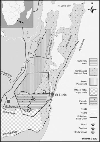
Here we will focus specifically on the banks of the lower part of the Mfolozi River and its associated floodplain (see Figure 1), an area that finds itself at the centre of struggles over realities. The river and its associated swamps were instrumental in attracting sugar cane farmers in the early 20th century, and the course of the river has been changed and manipulated to meet the needs of this land use. Commercial sugar cultivation now takes up two-thirds of the flood plain of 19,000 ha. The remaining third falls within the iSimangaliso Wetland Park, of which some parts are under extensive cultivation by small-scale subsistence farmers (Garden Reference Garden2008). The interests of large-scale agriculture, small-scale farming, tourism and conservation are thus intimately linked in their reliance on the Mfolozi River.
Sketch map of the larger St. Lucia area, indicating the various land uses and the land claim.

To the north, the riverbank gives way to the Dukuduku forest, one of the few coastal forests left in South Africa. However, large parts of the forest have been cleared and populated by what the authorities have described as squatters, who established themselves in the forest in increasing numbers from the late 1980s, a process described by authorities as an ‘invasion’ (DWAF 2000; DLGTA 2009). These people actually constitute a mix; some claim ancestral ties to the land, others have arrived in the last decades. Many of the residents give the same reason for settling in the area as that which led to the establishment of commercial agriculture south of the river in the 1920s – the extremely fertile riverbanks and associated floodplain. Some of the forest residents have now claimed the forest and the river, as well as parts of the park and adjoining farms, under the South African land restitution programme.
This is the case that we will use to examine the struggle over land uses and realities. We want to show that while it can be argued that people have been dispossessed of their land, putting the label ‘green-grabbing’ on these processes obscures the complexity involved more than it illuminates it. The next two sections examine the roots of the two main land uses in the St Lucia area, namely conservation and industrial forestry and agriculture. We then turn to an examination of the way in which these two uses relate and how the people living in the Dukuduku forest have been marginalised by both.
FROM HUNTING FIELDS TO PRESERVATION
One origin of present conservation efforts is to be found in colonial hunting practices. The Dukuduku forest is part of what came to be known as Zululand which existed as a British colony from 1887 until 1897, when it was annexed to Natal. During this period, the roots of what today constitutes conservation use of the land became established (Brooks Reference Brooks2001). Prior to British control, the absence of white settlement sustained an abundance of wildlife in the area, unlike neighbouring Natal where those species considered as game were soon eradicated by hunting and an expanding population.
In the mid-19th century, St Lucia emerged as one of the most important destinations for hunting expeditions from Natal. The value of exports of animal trade goods such as ivory, hides and horns made up a quarter or more of the total value of exports from the colony of Natal between 1845 and 1855 (Merrett Reference Merrett, Merrett and Butcher1991). The most important trade item was ivory, the export of which peaked in the mid 1860s. During the 50 years after the British annexation in 1856, some 800,000 kg of ivory were shipped from Natal and a substantial part of this came from the St Lucia area (McCracken Reference McCracken2008: 27).
Hunting also constituted an important symbolic part of colonial expansion, as MacKenzie (Reference MacKenzie1988) and others have shown. The colonial elites restricted access to game and redefined hunting from utility to sport to symbolise their racial and cultural superiority. In part, this redefinition of hunting was a reaction to the depletion of game that had taken place in previous decades. From 1887 onwards, several laws were passed to save the remaining big game in Zululand. This campaign, for the most part, reflected hunting interests. Most of the officials responsible for establishing British rule in Zululand were themselves hunters, and they imposed laws to protect game for hunting purposes (Brooks Reference Brooks2001). The laws that were passed also primarily protected those animals considered as game (see Nustad Reference Nustad2011a).
This early legislation centred on the animals themselves, and not on the areas that these animals inhabited. Protected areas in Zululand have their roots in official responses to complaints from Africans that wild animals were bringing diseases and destroying crops (Brooks Reference Brooks2001). This was in contrast to the situation in national parks in many parts of the world, and also in other parts of South Africa where landscapes were protected as instances of untouched nature.
Many Africans resented both the ban on their own hunting, and the fact that the preservationist legislation led to an increase in game around human settlements. This was a problem because the animals damaged crops and were seen as carriers of disease, particularly nagana (animal African trypanosomiasis), which was a major problem in the area at the time. Sir Marshall Clarke, appointed administrator to Zululand in 1893, responded to these concerns by relaxing the ban on hunting for Africans. To ensure that the game was preserved to some extent, he also proposed the establishment of five game reserves in areas where conditions made human settlement difficult (Brooks Reference Brooks2001). These reserves later became the present-day conservation areas open to tourists, one of which is St Lucia, proclaimed in 1895, which today forms the core of the iSimangaliso Wetland Park. However, this transformation took place in parallel with another land use that predominated from the beginning of the 20th century: industrial agriculture.Footnote 1
INDUSTRIAL AGRICULTURE
Zululand was opened for white settlement following the work of the Zululand Delimitation Commission between 1902 and 1904. The African communities who lived on this land now found themselves defined as ‘squatters’ according to the law. As with the earlier establishment of game reserves, Africans had very little say in the delimitation and spatial segregation of the land. Pressure on the game reserves increased as Zululand was transformed by industrial agriculture in the first decades of the 20th century. St Lucia and several other game reserves were deproclaimed between 1928 and 1939. The Zululand Lands Delimitation Commission and the Land Act of 1913 defined what today constitutes the park, as well as the Dukuduku forest bordering the park as Crown Land, i.e. as part of the area opened for white settlement.
A railway line to the district was established in 1903 for a coalmine at Somkele, between the present-day iSimangaliso Wetland Park and the Hluhluwe-Imfolozi Game Reserve. Mining ceased after a few years, but the infrastructure development brought with it new land use possibilities. Some even argue that the real motivation for the railway was to persuade the Delimitation Commission that the Zululand coast should be opened up for sugar production (Van der Merwe 1984).Footnote 2
A written account of the history of the district by a farmer and local historian refers to the ‘true pioneering spirit’ of these early settlers, and their ‘hardships and ill fortune in a subtropical, fever-ridden country [where unfolds] a unique and a dramatic [story] of courage and determination’ (Harrison 1970). Settlers arrived after the first farms on the Mfolozi flats were surveyed and allotted in 1911. These first settlers had broad experience from other parts of the British Empire, and came ‘with the idea of only temporarily residing at Umfolozi for a few years at the most for they honestly believed they would make a fortune in a short space of time from growing lush crops of sugar cane on the Umfolozi flats and leave wealthy men’ (Harrison 1970: 36).
Farmers along the coast of Zululand were encouraged to concentrate on sugar, as experiments had determined that it was the crop most suitable for these areas (Copley Reference Copley2009). When a sugar mill was established at Mfolozi in 1916, it had a further impact on the land use in the district, as new areas were consequently ‘opened up’ for farming to ensure that the throughput to the mill was sufficient to keep it viable. Some years later, the concerns of the farmers and the mill were taken to the minister by Heaton Nicholls, the first chairman of the Umfolozi Co-operative Sugar Planters, who claimed that the farming units of the flats were too small to be economically feasible. He suggested that all of the Dukuduku forest ‘be transferred to Crown Lands, and made available for settlement. It is a thick thorn belt, utterly useless for forest purposes, with no timber of any value in the forest’ (Heaton Nicholls 1927).Footnote 3
A host of disruptive factors added to the drama experienced by the pioneers. Regular flooding made the Mfolozi flats difficult to farm, but it was the same flooding that had turned the area into extremely fertile ground (Copley Reference Copley2009). Black inhabitants in the district warned the pioneer farmers of the dangers of floods on the Mfolozi flats (Harrison 1970), but as Minnaar suggests, the flats ‘were too fertile for the planters even to contemplate abandoning their farming operations’ (1989: 8). A flood in 1918 devastated farms, which again led to the establishment of a sugar farmer's co-operative. Another flood in 1925 destroyed the sugar mill and resulted in pressure on the government to find alternative land on the Lower Mfolozi delta to compensate those who had suffered most (Harrison 1970). Eventually, to prevent further disruption in the future, the farmers decided in the late 1920s to channelise the river.
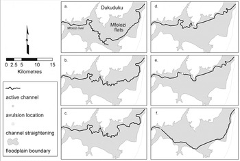
Garden (Reference Garden2008) illustrates the alteration of the Mfolozi River in relation to other changes to the course of the river over time (Figure 2). The earliest known course – of which traces can still be found – flowed through the southern part of the flood plain, where it partially joined the Msunduzi River (a). Later, partly through human alterations in the 1920s and 1930s, the river course was gradually shifted northwards, until it was channelised and became tangential to the Dukuduku forest (b–e).
Interpreted recent avulsion history of the Mfolozi River: a–c, pre-human intervention; d, 1937; e, post 1937 and f, following 1988 cyclone. (Modified from Garden Reference Garden2008: 160).

The dredging and straightening of the river changed and engineered the landscape for a specific land use, but the channelisation of the river also had unintended effects. Sediments were being washed downstream, leading to massive siltation in the estuary and the closure of the connection between the estuary and the ocean, referred to as the estuary mouth. At the time this was regarded as a catastrophic development for the lake and it did severely affect the fish population. Contrary to what ecologists now argue, that it is natural for the mouth to be closed for certain periods, a permanently open estuary mouth was then seen as important. The course of the river was accordingly changed in the 1950s by blocking its path into the estuary and creating a new path to the Indian Ocean (Copley Reference Copley2009).Footnote 4
CONSERVATION AND INDUSTRIALISATION
Several authors have pointed out that there is a close connection between the transformation of landscapes as a result of industrial capitalism and the singling out of ‘nature’ as a separate part of our environment that needs to be protected (e.g. Bunn Reference Bunn, Darian-Smith, Gunner and Nuttall1996). This apparent contradiction, between landscapes that are seen as untouched, primordial and ancient, and that of landscapes perceived as transformed, has been played out in a number of ways in St Lucia. One view regards the transformation as improvement, as rescuing the landscape from idle wilderness. Heaton Nicholls, one of the pioneer settlers, for example, wrote in his autobiography: ‘[The Mfolozi flats] was a waste of forest, papyrus and elephant grass in the river delta […] To tame this wild place and bring it into fruitful production appeared a man's full sized job’ (Heaton Nicholls Reference Heaton Nicholls1961: 92–3). But as Bunn has argued, the taming of wilderness also led to a longing for the wild and the untamed:
‘Nature’, in South Africa, becomes significantly problematized at a time when agriculture is modernizing, when it is reducing the eco-environment to an exchange value and hastening the destruction of sharecropping and the smallholder's sustained utilization of resources […] there was a critical point at which modernizing agrarian capitalism in Natal visibly began to destroy the ‘natural’ environment fast becoming a valued tourist commodity amongst the white population, and it is not surprising to find a compensatory logic in which value comes increasingly to reside in those landscape features that appear to predate these effects. (Bunn Reference Bunn, Darian-Smith, Gunner and Nuttall1996: 43)
Hence, as the sugar industry rescued the coastal Zululand from ‘primeval wilderness’, it unleashed new wilderness values. However, these processes are never as straightforward as they might seem in retrospect. Strong forces attempted to exterminate the wild animals because of the threat they posed to cattle, and the park was, as we have seen, indeed deproclaimed in the 1930s. A growing conservation movement aligned itself with a new-found appreciation of ‘primordial landscapes’ by urban dwellers and managed to establish the importance of conservation areas for tourism (Carruthers Reference Carruthers1995; Brooks Reference Brooks2000; Brooks Reference Brooks2005; Fay Reference Fay2007; Fay & James Reference Fay, James, Fay and James2009). In 1966, government plans to build a dam on the Hluhluwe River (another tributary to the lake complex) in order to control the periodic flooding of the river, led to the first public protest cast in a recognisable modern conservationist framework. In 1977, the Natal Parks Board and the Department of Forestry decided to jointly manage the eastern shores of the park, and in 1986 the St Lucia complex was declared a wetland of international importance under the Ramsar Convention. In 1999 the wetland park was listed as South Africa's first World Heritage Site. The St Lucia area thus became subject to two visions and two ideas about what it ought to be: a conservation area representing to its visitors an image of untouched primordial Africa, where traces of past disturbance and destructions should be healed, and its opposite, prime agricultural land represented by the sugar cane fields. It is this same opposition, between industrial agriculture and the parallel vision of an untouched landscape, which today plays itself out in the conflict over the use of the Mfolozi River and flood plain.
SETTLEMENT AND LAND USE IN THE DUKUDUKU FOREST
To understand this conflict we need to return to the historical settlement patterns of the larger Dukuduku area. These play a vital role for the various claims on the forest in recent times, as they have significant implications for both the validity of claims of ancestral belonging, and for the idea of the pristine quality of the forest. It is generally assumed that there has been very limited habitation in the Dukuduku forest, and that the little that did occur was limited to the forest margins (see Sundnes Reference Sundnes2013b). Forestry officials at the beginning of the 20th century described Dukuduku as ‘scattered malarial bush’ and warned that travelling there in summer was highly dangerous (Sim 1907). This danger has been attributed to the density of the forest, the surrounding wetlands and the near-subtropical climate. However, through detailed examination of historical data, Sundnes (Reference Sundnes2013b) suggests that the forest was probably used and inhabited beyond the marginal at least since the 18th century. Moreover, the imagined dense and impenetrable historical forest does not correspond with the actual landscape change. Forest regulations and forced removals from the 1930s ensured that little permanent habitation in the forest took place until the informal resettlement in the 1980s. We will show, however, that parts of the forest area still was inhabited and used during this period.
The first source with which we can determine with some accuracy the habitation patterns and densities of people within and around the forest are aerial photos taken in 1937. This is however seven years after the first forced relocation in relation to the establishment of the forestry industry in the region took place (Sundnes Reference Sundnes2013b). An interpretation of these photos shows that most of the people in the area at this point lived outside the forest to the north, towards the western shores of the St Lucia Lake, but that some 30 households were found in the forest proper (KZNW 1992).
What is striking, however, is that most of these households are found in the southern part, where the sugar farmers’ village, Monzi, later was established, as well as the southern-eastern section of the forest. These are the parts of the forest closest to the Mfolozi River and the floodplain (KZNW 1992; Zululand Observer 12.10.1989). This suggests that the transitional areas (from forest to swamp) such as the river bank were important assets. These were also the areas to which people first moved when the ‘invasions’ started in the late 1980s. Further, these areas of the forest have been in use during most of the 20th century, and one important reason for this is the interactions with the industrial farmers; directly through employment, or indirectly through alteration of infrastructure.
Minnaar (Reference Minnaar1989), in his account of the development of the sugar industry in Zululand, claims that many Zulu men were reluctant to work on the sugar plantations. The farmers therefore also had to resort to non-local and foreign labour. Men from further north in Maputaland, Tongaland and southern Mozambique were considered more efficient and better adapted to the conditions of the swamps on the flats, as they were more resistant to malaria. Although the government prohibited the hiring of foreign labour in 1921, some farmers continued this practice. The ban was further strengthened in the early 1960s, but while labour repatriation took place, ‘many slipped back across the border and made their way to their former places of employment’ (Minnaar Reference Minnaar1989: 106). In this context the Dukuduku forest provided refuge for labourers who chose to return (Cooper 2008 int.).
A report in 1959 by an official of the Department of Forestry tells of problems with squatters in the part of the Dukuduku Forest in the vicinity of the farmers village, Monzi: ‘[The area is] overrun with huts and stock of squatters who have drifted in from adjoining forest reserves. [It] is riddled with Bantu virtually hiding in the deep recesses of almost impenetrable bush […]. Conditions existing in the crown lands are deplorable, inviting breeding grounds for crime and disease.’ The report makes no mention of whether these are workers on the farms or not. Others have however claimed that farm workers and their families cultivated small fields on the borders and fringes of farms and on the riverbeds (Minnaar Reference Minnaar1992; Cooper 2008 int.).
Roads into the forest have also had an impact on settlements. In the mid 1960s a road was made into the southern section of the forest for a sisal plantation scheme that never materialised (see Sundnes Reference Sundnes2013b). Further, in the late 1970s the provincial authorities and the Natal Parks board built a canal from the Mfolozi River to the estuary to allow excess water into the estuary system. In this same operation a road through the Dukuduku forest was made to allow a dredger boat onto the river (Perry 2009 int.). The making of these roads might have facilitated access to the forest by those wanting to settle there. An early investigation by the provincial authorities in 1989, when people had just started to settle in the forest, identified the new places of habitation just in between these two roads. It is important to note, however, that the roads also led to parts of the forest close to places of earlier settlements.
Erratic weather and climate conditions have had an impact on the sugar growers throughout their history in the district, and also in more recent times. Two major tropical cyclones and consequent flooding in 1984 and 1987 destroyed many sugar farms and put some of them under several metres of deposits of silt and sand. Many Africans who for years had cultivated small fields on land that had become available through the sugar farmers’ infrastructure lost their lives, while others were displaced from the swamps and wetlands to the high-lying areas of the forest (Blewitt 1989; Zululand Observer 12.10.1989). Thus the cyclones may be one factor explaining the sudden influx of people into Dukuduku from the late 1980s. These cyclones shifted the Mfolozi River back to its southern course (Figure 2f), but by 1988 the river had again been moved back to the channel alongside the Dukuduku forest (Garden Reference Garden2008). The floods and the consequent shifting of the Mfolozi River may have opened up new areas for small-scale agriculture south of the Dukuduku forest on attractive and fertile ground, but it is also possible that they renewed access to areas that were previously used.
RESETTLEMENTS FOR CONSERVATION
These informal settlements have however been resisted by the authorities. People have been evicted from the Dukuduku forest at different times and for various reasons during the last century. Forced removals took place between the 1930s and the 1970s as new areas were put under forest plantation schemes (see Sundnes Reference Sundnes2013b). More recently, there have been other attempts at removals or resettlement, this time involving the group of people who had begun living in the forest in the late 1980s. At this time, 30 ‘squatter’ families were reported in the forest, and their presence seems to have contributed to speeding up the process of securing the conservation status of the greater St Lucia area and of enclosing Dukuduku within the fold of conservation management and declaring it part of the park.
As happened in other areas of South Africa, many people began to test the apartheid government's resolve towards the end of the 1980s, when it was becoming increasingly clear that a political change was imminent.
While the forced removals during Grand Apartheid were successful in the way they paved the way for forestry and other ‘white interests’ such as conservation and agriculture from the 1950s up until the 1970s, the various attempts at evicting and resettling the forest dwellers of Dukuduku in the last decades tell of major government failure and immense local opposition. The re-establishment of human settlement within the Dukuduku forest first received public attention in 1989 when around 300–400 people were reported to be illegally settling in the forest. Successive ministers of forestry and water affairs announced plans throughout the 1990s that would ‘solve the problem of Dukuduku’, subsequently announcing that ‘the forest is [now] saved’ (Natal Witness 07.12.1998; 20.01.1999). Two initiatives are noteworthy.
The first resettlement scheme commenced in 1990, when an area on the outskirts of the Dukuduku forest consisting of grasslands, wetlands and indigenous forest was made available by the Department of Forestry, after extended negotiations, for the establishment of a permanent settlement which was later to be named Khula village. The resettlement area was to accommodate all the forest dwellers – at that time numbering some 8,000 to 15,000 people. In fact, resistance and internal disagreements led to only a few hundred people moving. Since the settlement area was set up as a township, there was little provision of land for grazing and cultivation. While the majority of the people remained in the forest, people from elsewhere moved in to occupy the now ‘available lots’ within the forest (AFRA 2002).
In 1998 another relocation attempt was initiated. Learning from the previous experience, the plan was now to form an agri-village settlement on land suitable for agriculture (AFRA 2002). Two commercial sugar farms, on an area that up until the 1960s had formed part of the Dukuduku forest, were purchased by the government. However, negotiations failed at the ‘last minute’ due to opposition from the forest leaders and intimidation of those signing up for the new scheme. The result was that many of the people moving in to this settlement, today known as Zwenelisha, were people from elsewhere in the district, not the ‘squatters’ for whom it was intended.
Both resettlement initiatives are today considered failures, and have in many respects only aggravated the problems. Not only has the number of people illegally settled in the forest grown, but with the many ‘outsiders’ moving in to the forest in the wake of the resettlements, the number of people that need to live off the area and its livelihood and employment opportunities has increased dramatically. Both initiatives were beset by a lack of funding, with the result that services that had been promised were not delivered. Some did not receive fields for cultivation and others had to build houses for themselves. These experiences, and several cases of conflict with various arms of the government, have led to the perception among many forest dwellers that new plans and initiatives are just inventive ways of dislodging them and securing the forest and the floodplains for conservation. This has resulted in yet new levels of forest destruction and chronic distrust. In response, some of the inhabitants sought to use the post-apartheid land reform laws to claim the land as rightfully theirs. But, in a similar way that dispossession was not a specific moment in time, but rather the outcome of historical processes, restoration through land reform has proven to be difficult too.
THE DUKUDUKU LAND CLAIM
Land policy was one of the most hotly debated issues and the last to be settled in the negotiations between the African National Congress (ANC) and the National Party Government prior to the first democratic elections in 1994 (Walker Reference Walker2008). Many factors shaped the outcome of these negotiations (Hall & Ntsebeza Reference Hall, Ntsebeza, Ntsebeza and Hall2007; Walker Reference Walker2007, Reference Walker2008; Hellum & Derman Reference Hellum and Derman2008; Lahiff Reference Lahiff2008). In the end a land reform programme with three components was adopted: first, restitution of land to those dispossessed after 1913; second, redistribution of land to rectify the racially skewed distribution of land that resulted from colonial and apartheid policies; and third, tenure reform for those whose tenure was insecure because of past discriminatory laws and practices (Lahiff Reference Lahiff2008).
The Restitution of Land Rights Act, No 22 of 1994, set up an apparatus whereby a chief land claims commissioner would oversee the regional land claims commissions, which in turn would investigate cases and bring them before the Land Claims Court for settlement (Hellum & Derman Reference Hellum and Derman2008: 68). Because of the slow initial rate of delivery, the Restitution Act was amended in 1999 to provide for administrative settlements of claims: the Land Claims Court would now be used only in those cases where agreement could not be reached – as was the case with Dukuduku.
Although the land issue was seen as one of the key challenges for the post-apartheid government, the land reform programme has been slow to deliver any significant changes in land distribution. One important reason for this, as both James (Reference James2007) and Walker (Reference Walker2008) have pointed out, is that the post-apartheid land reform programme was meant to accomplish two often contradictory goals. The master narrative on land reform, of turning back the clock and restoring a pre-dispossession situation, played an important role in establishing people's sense of justice. It therefore complemented the work of the country's Truth and Reconciliation Commission (Wilson Reference Wilson2001). The actual redistribution of land was equally important, but much more difficult, for several reasons. First, many years had ensued since the original dispossession. The people who applied for compensation would in practice often be the descendants of the original owners, people who had settled elsewhere and established themselves in new settings. Second, determining who these descendants were and establishing the actual documentation of their family connections to those who were originally dispossessed were fraught with difficulties. Third, many other people had often in the meantime established moral claims to the land in question. And fourth, the dispossessed land might in itself have been transformed fundamentally, as was the case in Dukuduku.
In 1998, a group of forest dwellers contacted the Association for Rural Advancement (AFRA), a land rights non-governmental organisation based in Pietermaritzburg, and requested help to file a claim for the land (Nustad Reference Nustad2011b). A claim on the forest was subsequently lodged with the Regional Land Claims Commissioner just before the cut-off date of 31 December 1998. The land claim at Dukuduku has been a long, drawn-out process. The Land Claims Commissioner insisted that the claimants compile a list of the people on whose behalf the claim was made before she would consider the case. This was probably because of the widespread perception of conservationists and politicians, stated in the media, that the residents in the forest had moved in recently and thus did not have a claim to the area. This is only partly true. Our research revealed that although some people claimed ancestral rights to the forest, a large portion, more than half of the population, had moved into the area towards the end of the 1990s. This part of the population thus had no right to the land under the restitution process, and they feared that they would be dispossessed should the claim succeed. The claim process was further complicated by the lodging of an overlapping land claim (see Sundnes Reference Sundnes2013a). A decision on the Dukuduku claim was only reached in 2002, when the commission turned it down.
AFRA and the claimants took the decision to the Land Claims Court and won the case in 2003. The judge stated that the commission had neglected its duty and ordered it to gazette the claim. It is unclear what the actual disagreement was all about, but the judgement refers to the original letter informing the applicants of the dismissal of their claim as invalid, and points out that the reasons given by the commissioner are not in compliance with the law. These reasons included that people were living on the land they were claiming, that they had decided to return to the land, that the claim was lodged to hinder interventions in the area by the Department of Water Affairs and Forestry, and perhaps most importantly, that ‘people have been repeatedly advised to furnish the Commission with people that were removed to no avail’ (ZALCC 2003). The judge rejected this last statement as factually incorrect, pointing out that the applicants had provided a list of people moved. The Land Claims Court set aside the decision of the commissioner and judged the claim to be a valid one. It is difficult to know why the commission dismissed the claim, but a likely reason is the very fact that a large part of the population living in Dukuduku at the time when the claim was submitted had moved into the area in the 1990s and thus had never been forcibly removed (Sundnes Reference Sundnes2013a). This, however, does not detract from the fact that there were people who had been forcibly removed in previous decades.
The claim was gazetted later in the same year, without a specific demarcation of the land being claimed. Only in October 2007 was the land claim fully gazetted, in a form that included the whole of Dukuduku, part of the estuary that borders on St Lucia town, and land under forest plantations as well as several white-owned sugar cane farms. The Dukuduku land claim remains unsettled to this day.
In the ongoing land restitution process, commercial farmers and land owners whose land is now under claim have argued that human presence was minimal in the area, since no human settlement was possible near the floodplains, which were impenetrable before the onset of large-scale agriculture and subsequent draining operations (Hopwood 2009 int.). Farmers have also objected to the land claim on the grounds that the borders of the land claim curiously follow the roads that the same white farmers or the forestry sector constructed after removal of the local people. However, a comparison of the present land use with early maps of the district clearly shows that farming settlements (i.e. Monzi) and roads were to a large extent constructed where ‘native kraals’ and ‘native paths’ used to be (Sundnes Reference Sundnes2013b). Hence, there are layers of history and land use not visible to the eye, nor present in living memory (Beinart & Bundy Reference Beinart and Bundy1987).
The shifting nature of the river also has implications for the land claim, as it forms a point of reference for the extent of the claim (AFRA 2006). While the land claim according to the claimants extends onto the Mfolozi flats, a former course of the river, the park authorities have been using the present course and channel – closer to the forest – as the border beyond which there should be no informal cultivation. The employment of security guards by the wetland park authorities to curtail these activities in the area between the two river courses has been an issue of contention between the park and the forest dwellers (AFRA 2008). One forest dweller made his view clear in a group discussion: ‘Mfolozi badly affects us, as it gives no space to expand our work. […] If things could be as we wish, would the Mfolozi be moved back to its original route so that our fields will be on our side. […] Government should assist the community by bringing Mfolozi back to its original routes.’Footnote 5
CONCLUSION
As the case of the conflict over Dukuduku demonstrates, dispossessions that involve conservation, sometimes referred to as green-grabbing, raise issues other than the legal ownership of land. Taking into account the nature of the land involves including other actors than the purely human. At the centre of the many competing realities on the Mfolozi flats is the role of the Mfolozi River. Its fertile riverbanks have attracted both commercial agriculture and the inhabitants of the Dukuduku forest. It forms part of the estuary system that has attracted wildlife and people for centuries, and which today is an important part of the conservation area and a prime destination for fishing tourists. The river has been shifted, channelised and dredged, and had its outlet moved to suit the needs of different uses. The river and its course, past and present, have also been used to claim ownership to the area. It therefore forms part of different competing realities, and is a marker for historical claims on the forest and the floodplain.
While people have certainly been dispossessed, labelling these historical processes as green-grabbing obscures the way in which the present situation is the outcome of centuries of struggle, not just over ownership, but over realities as well. For as we have argued, the nature of the land itself is at stake. The wetland area, which served as hunting grounds in the past, was transformed into productive fields at the beginning of the 20th century and then cast as an object of conservation from the middle of that century. It is now subject to an open-ended conflict over what its future will be. This struggle over the nature of the land lies at the heart of the controversy surrounding the land claim. As we have argued, the question is not only whose land this is; what is at stake is what this piece of land is to be in the future.