Introduction
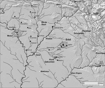
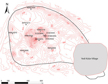
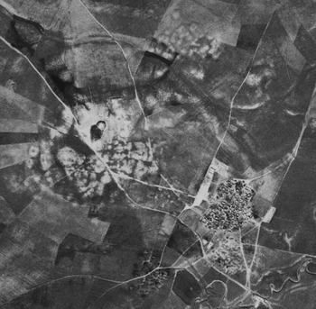
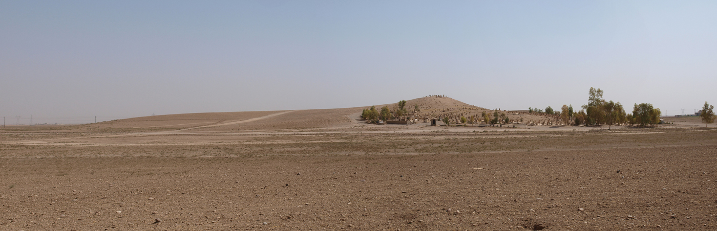
Encompassing an area of some 109 hectares, Kurd Qaburstan is one of the largest archaeological sites on the Erbil plain of northern Mesopotamia.Footnote 2 The site is located approximately twenty-two kilometres southwest of Erbil in the Kurdistan Region of Iraq (Figs. 1–4). In June-July 2013 and May-June 2014, the Johns Hopkins University conducted two field seasons at the site as part of a project focused on the character of second millennium b.c. northern Mesopotamian urbanism. This report presents the major results of those two seasons.Footnote 3
Kurd Qaburstan and the Erbil region. Map by Jason Ur

Kurd Qaburstan. Contour interval 0.5 metres. Solid line around site approximates location of city wall

CORONA satellite photograph of Kurd Qaburstan

Kurd Qaburstan, view of central high mound from the southwest. Photograph by Jason Ur
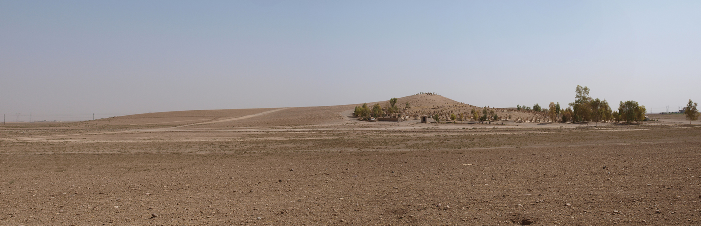
Kurd Qaburstan consists of a central, eleven hectare high mound with three recognizable peaks of elevation on the west, east and northeast (sixteen metres maximum elevation), and a ninety-eight hectare lower town (four metres maximum elevation). CORONA satellite imagery and visual observation of the modern landscape indicate that the site was demarcated by an enclosure wall. In the south-eastern part of the lower town is the modern village of Yedi Kizlar, while the modern cemetery referred to in the site name is located on the western part of the high mound.
Given its large size, we infer that Kurd Qaburstan was a settlement of considerable economic and/or political importance. If so, this might be correlated with the site's location near the watershed between the Upper and Lower Zab rivers as well as its proximity to a gap in the Avanah Dagh hills between Makhmur and Erbil (Ur et al. Reference Ur, de Jong, Giraud, Osborne and MacGinnis2013). Annual rainfall in the present day is c. 300–400 millimetres/year, which, together with the adequate soils of the plain, would have allowed for productive dry farming in the region if the rainfall patterns were similar or more favourable in antiquity (Buringh Reference Buringh1960: 43–44; Wilkinson Reference Wilkinson2003: 18, fig. 2.1).
In 1976, Kurd Qaburstan was identified as site 35 on Map 3 in the Atlas of Archaeological Sites in Iraq (National Directorate of Antiquities Iraq 1976).Footnote 4 The Erbil Plain Archaeological Survey (EPAS) directed by Jason Ur of Harvard University conducted surface sherd collection in 2012, designating the mound as site 31 (Ur et al. Reference Ur, de Jong, Giraud, Osborne and MacGinnis2013: 99–100). Given the surface sherd data, Ur and his team concluded that the main habitation period of the lower town was the early second millennium b.c. (Middle Bronze Age/Old Babylonian period), in addition to a significant Islamic period occupation south of the high mound. On the high mound, traces of occupation extended from the early third millennium b.c. to the second millennium a.d.
Because of the site's prodigious size and early second millennium b.c. occupation, Ur et al. (Reference Ur, de Jong, Giraud, Osborne and MacGinnis2013) concluded that Kurd Qaburstan was a large urban centre of the Middle Bronze Age (c. 2000–1600 b.c.) and suggested an identification with ancient Qabra, the capital of a kingdom based in the Erbil region (Charpin Reference Charpin, Attinger, Sallaberger and Wäfler2004; MacGinnis Reference MacGinnis2013b). Two stone steles celebrate the defeat of the king Bunu-Ištar of Qabra and the capture of his capital by Šamši-Adad of upper Mesopotamia and Daduša of Ešnunna (Ismail and Cavigneaux Reference Ismail and Cavigneaux2003; Schwartz Reference Schwartz, Aruz, Graff and Rakic2013: 5, figs. 1a, 1b). After the death of Šamši-Adad, Qabra regained its independence, and we learn of a diplomatic marriage between Qabra and the kingdom of Qatna in western Syria from a Mari document (Charpin Reference Charpin, Marti, Nicolle and Shawaly2015). Although textual references to Qabra are confined to the Middle Bronze/Old Babylonian period, some authorities suggest that the town of Baqarru cited in Neo-Assyrian sources is a later rendition of the same toponym (Deller Reference Deller1990).
Previous investigations of second millennium Mesopotamian urbanism have almost exclusively focused on southern Mesopotamia (e.g. Adams Reference Adams1981; Huot, Rougeulle, and Suire Reference Huot, Rougeuelle, Suire and Huot1989; van de Mieroop Reference van de Mieroop1997; Stone Reference Stone and Stone2007) or the Syrian Jezireh (Weiss Reference Weiss1986; Akkermans and Schwartz Reference Akkermans and Schwartz2003: 253–67; Margueron Reference Margueron2004; Matney Reference Matney and Potts2012; Ur Reference Ur2010a; Ristvet Reference Ristvet2014). Northern Iraq, in contrast, has received very little attention, due to the relative paucity of archaeological fieldwork conducted there. The preeminent exception is the project of excavations at Tell al-Rimah (= ancient Qattara?) on the Sinjar plain directed in the 1960s by David Oates (Oates Reference Oates and Curtis1982; Postgate, Oates, and Oates Reference Postgate, Oates and Oates1997). Although excavations were conducted at Assur, second millennium results prior to the Middle Assyrian period are fragmentary or ambiguous (Bär Reference Bär2003; Beuger Reference Beuger, Luciani and Hausleiter2014). Thus, new fieldwork at a north Mesopotamian urban centre such Kurd Qaburstan offers an opportunity to expand understanding of northern Mesopotamian urbanism in the second millennium b.c.
At Kurd Qaburstan, we aim to examine the spatial distribution and character of domestic remains, craft production loci, fortifications, and large-scale public architecture. Among the issues to be addressed are the recognition of neighbourhoods and their defining traits (e.g. kinship, social status, profession) (Smith Reference Smith2010), the evidence for central planning (Smith Reference Smith2007; Harmanşah Reference Harmanşah2013), and symbolic and ideological aspects of urban space (Carl et al. Reference Carl, Kemp, Laurence, Coningham, Hingham and Cowgill2000). In this research, we hope to study urban space as both a product of daily practices and as a shaper of the thoughts and actions of humans at the site (Smith Reference Smith2003; Rapoport Reference Rapoport, Ashmore, Dobres, Nelson and Rosen2006; Smith Reference Smith2011).
Several models have been advanced to evaluate and characterize second millennium urbanism in Mesopotamia. In upper Mesopotamia, some scholars have proposed that early second millennium b.c cities were “hollow”, founded by Amorite rulers as impressive statements of power with monumental palaces and temples but lacking a dense population (Oates Reference Oates1985; Ristvet Reference Ristvet, Laneri, Valentini and Pfälzner2012: 43; Ur et al. Reference Ur, de Jong, Giraud, Osborne and MacGinnis2013: 100). In this scenario, the early second millennium rulers demonstrated their power by constructing new urban emplacements that harked back to the urban centres of their third millennium predecessors, but these Middle Bronze Age cities did not have the concomitant population. In southern Mesopotamia, Elizabeth Stone and Paul Zimansky (Stone Reference Stone and Stone2007; Stone and Zimansky Reference Stone and Zimansky2004) have proposed that urban centres were characterized by a heterarchical social organization in which multiple competing institutions shared power. They contend that such heterarchy is manifested by the spatial organization of southern Mesopotamian cities, where palaces and temples are located at significant distances from one another and neighbourhoods are characterized by kinship ties rather than social or economic status. We hope to test these and other models of second millennium urbanism in our work at Kurd Qaburstan.
Fieldwork Goals
In the first two seasons of the Johns Hopkins project, fieldwork aimed at three goals:
-
1. Sampling different parts of the site through excavation to determine their character and history of occupation and to guide future excavation strategy, with particular focus on the Middle Bronze period;
-
2. Testing the hypothesis that Kurd Qaburstan was a large city of the Middle Bronze Age;
-
3. Implementing a geophysical survey project to study the urban layout of the site.
In the 2013 season, the Johns Hopkins team utilized the results of the EPAS survey for data on the surface sherd distribution. Since that survey only covered selected parts of the site, the EPAS data were supplemented by a surface collection conducted in the first two days of the 2014 Kurd Qaburstan field season in areas where excavation was feasible.Footnote 5 The results suggested that the main periods of occupation on the southern lower town were Islamic and Middle Bronze, while the northern lower town was dominated by Middle Bronze sherds alone. It thus seemed likely that Middle Bronze remains would be more accessible to excavation in the northern lower town.
Excavation Results
Late Bronze Remains, High Mound
Trenches were opened on three locations on the high mound, to the east, north, and west. Immediately below the site surface in all three areas were intrusive burials without associated artefacts, so their date is uncertain. However, it is possible that they belong to the Achaemenid period, as is proposed for the intrusive burials found on the High Mound South Slope (see below).
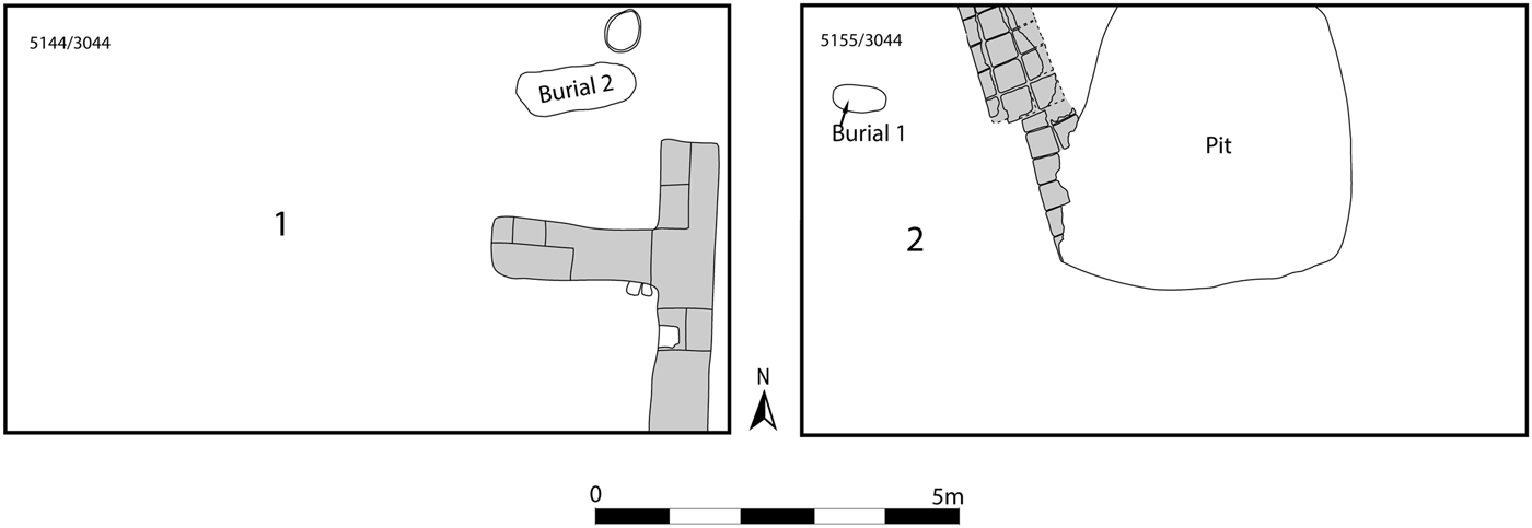
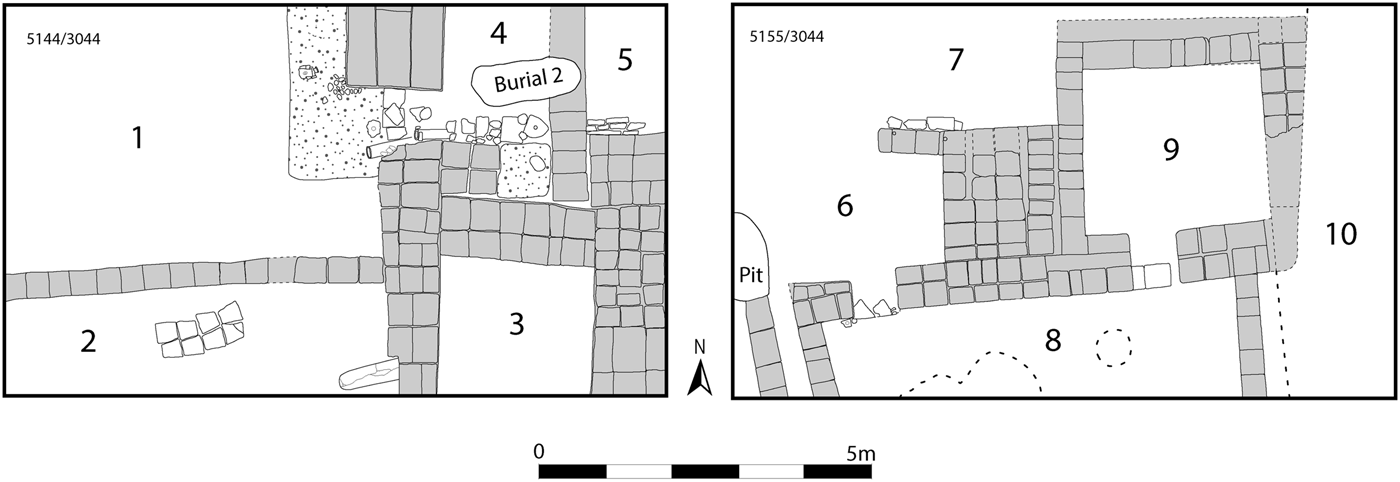
On the High Mound East, three 6 × 10 metre trenches and one 2 × 20 metre step trench were excavated in an east-west line. Stratified prior to the late intrusive burials discussed above were three phases of occupation datable to the Late Bronze (Mittani) period, c. 1500–1300 b.c., in deposits excavated to 1.75 metres in depth. Phase 1, the latest of the three, included poorly preserved architecture and two pit burials (Fig. 5). In area 1 to the west were two fragmentary lime-plastered mudbrick walls two bricks wide associated with a lime-plastered floor to the south. Occasionally, pieces of kiln-fired bricks had been inserted inside the mudbrick walls, a practice also noted in other Mittani contexts at the site. In the debris near this architecture were abundant slag fragments, indicating the presence of pyrotechnic activity. To the east in area 2 was more fragmentary mudbrick architecture and a large pit that contained ashy debris and over a hundred snail shells.Footnote 6
Phase 1, Late Bronze, High Mound East

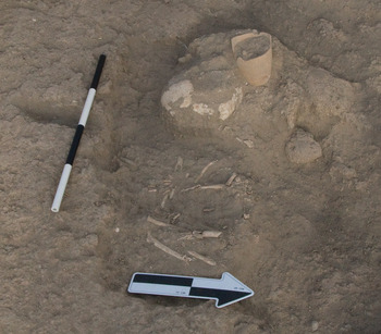
Burial 1 (Fig. 6) was the grave of a child buried in a flexed position that included a painted Younger Khabur Ware goblet standing upright at the rear of the skull (Fig. 30: 16) and tiny oblong bone beads carved with a grid pattern found below the skull. Another painted Younger Khabur Ware goblet (Fig. 30: 17) was found nearby and may have likewise derived from burial 1, which had been disturbed by a later pit.
Burial 1, looking west

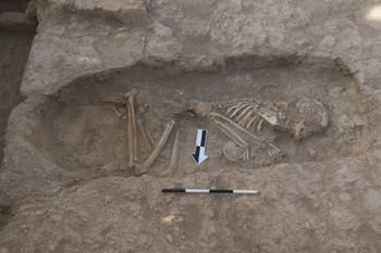
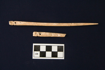
In burial 2, which had been capped by a line of eleven vertical mudbricks, was the flexed skeleton of a young adult female (Fig. 7). By the hands, with two fingers of the right hand extending inside, was a glazed ceramic bowl (Q-2) (Fig. 30: 18), and north of the face was a fine, tall, slender high-necked “Kassite goblet” (Fig. 30: 15) (cf. Armstrong and Gasche Reference Armstrong and Gasche2014: plates 99–103, Group 215A2).Footnote 7 Between the two arms were two bone toggle pins with fist-shaped headsFootnote 8 (I-14, I-15) (Fig. 8), two small spherical red stone beads, and two cylindrical faience beads. Underneath the skeleton were several body sherds lying horizontally, perhaps placed as a bed for the body of the deceased. Regarding the date of this burial, it is possible that it derived from a post-Mittani (Middle Assyrian) phase, since many of the parallels for the Kassite goblet are dated to the thirteenth century by Armstrong and Gasche (Reference Armstrong and Gasche2014), and a good parallel for the fist-headed pins originates from a Middle Assyrian tomb at Assur.
Burial 2, looking south. “Kassite goblet” had been removed prior to photograph

Bone pins from Burial 2 (I-14 top, I-15 bottom)

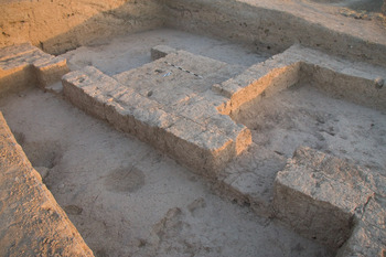
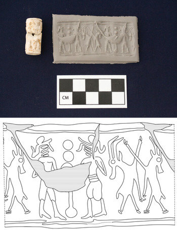
Phase 2 had mudbrick architecture with lime-plastered walls and floors (Figs. 9, 10).Footnote 9 Of particular interest in areas 1–2 and 5–7 (and, to a lesser degree, area 8) was the discovery of numerous bone pins or needles and of bone segments that had the marks of bone tool production (see section Faunal Analysis, below). Also found in the debris of phase 2 area 7 was a cylinder seal of the Mittani Common Style made from a greyish-white composition material (“frit” or “sintered quartz”) (Salje Reference Salje1990) (Fig. 11, G-2). The seal depicts a relatively typical Common Style scene, with two male figures flanking a pole-tree and two upright gazelles occupying the space to the left. However, specific aspects of the scene are unusual. Although the two gazelles confront one another with heads turned away, a relatively standard pose,Footnote 10 it is uncommon for one front leg to extend upward and crossing while the other front leg hangs down. Likewise, the “pole-tree” or standard between the two males is less common than the characteristic “bouquet” tree.Footnote 11 The use of the cutting wheel to create the lines of the face and the round drill bit to form the cap find a close comparison in a seal with a similar composition from Mittani-period Tell Brak.Footnote 12
Phase 2, Late Bronze, High Mound East

Phase 2, Late Bronze, High Mound East, Areas 6–9. Looking northwest

Mittani Common Style seal (G-2) and impression. Phase 2, Late Bronze, High Mound East

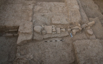
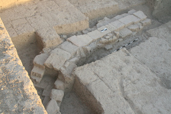
In areas 4 and 5 to the west was a drain consisting of two cylindrical ceramic pipes (diameter = c. 14–16 centimetres) and a cover of complete and fragmentary baked bricks (Fig. 12).Footnote 13 The drain began in a pebble-paved surface in area 1 and sloped down to the east below the mudbrick wall between areas 4 and 5, emerging in area 5 as a baked brick conduit. In area 2 was a small “pathway” constructed of two rows of trapezoidal baked bricks, ostensibly recycled from a well or a vaulted structure.Footnote 14 A ceramic container extending west from the west wall of area 3 is of uncertain function. We presume that the activities taking place in this phase included craft production as well as domestic concerns, although the paucity of in situ features limits interpretive possibilities.
Drain, phase 2, Late Bronze, High Mound East, Areas 4–5, looking south

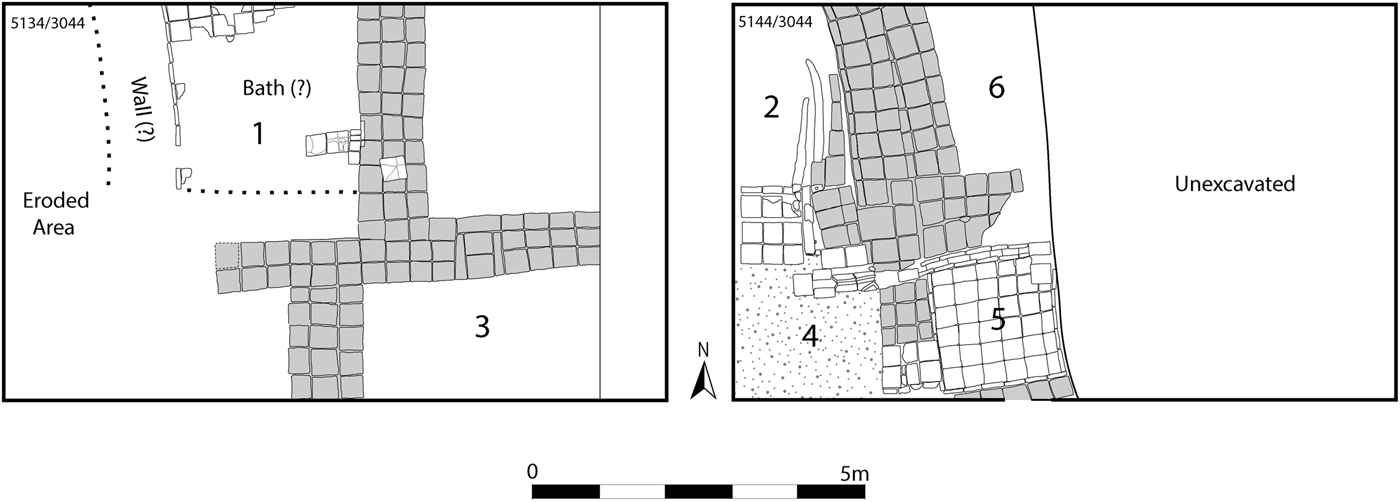
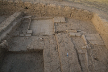
An elite residential character can be attributed to the remains in the earliest excavation occupation, phase 3 (Fig. 13), with its relatively thick mudbrick walls and elaborate drainage systems equipped with ceramic drainpipes and baked brick water conduits (Fig. 14). The doorways between areas 2 and 4 and areas 4 and 5 had baked brick thresholds. Especially notable was the square installation in area 5, c. 1.95 metres per side, which had a baked brick floor and edges formed by a line of vertical baked bricks. The floor of the feature sloped down from south to north (with a difference in elevation of up to thirty-one centimetres) toward a drain lined with baked bricks that bordered the north wall of the construction. We interpret this square feature as a bath, comparable to examples at Nuzi (Starr Reference Starr1937: 166), Hammam et-Turkman (van Haaften Reference van Haaften and van Loon1988: 132), Alalakh, and elsewhere (Fink Reference Fink, Fantalkin and Yasur-Landau2008). In the northeast corner, two stacks of three baked bricks may have functioned as a seat for the user of the bath.Footnote 15
Phase 3, Late Bronze, High Mound East

Phase 3, Late Bronze, High Mound East, Areas 2,4–6, looking south

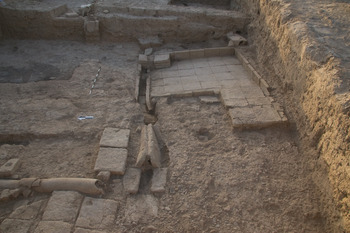
On the floor in the north-eastern part of room 4, west of the bath, was a feature that included two parallel thin baked bricks interpretable as the foot-stands of a toilet, connected to the drain bordering the northern edge of the bath (Fig. 15). Immediately to the east of the toilet, the drain was covered by two rows of baked bricks positioned in a V shape, comparable to Late Bronze Age toilets at Alalakh and other sites (Fink Reference Fink, Fantalkin and Yasur-Landau2008; McMahon Reference McMahon and Mitchell2015). The floor of room 4 was paved with small pebbles, reminiscent of plaster floors with small crushed stones in rooms that contained toilets at Alalakh (Fink Reference Fink, Fantalkin and Yasur-Landau2008).
Toilet and bath, Phase 3, Late Bronze, High Mound East, Areas 4–6, looking east

Just north of the toilet, a drain composed of cylindrical ceramic conduits ran from south to north immediately east of the baked brick threshold between rooms 4 and 2, connecting to two earthen drain borders in the southeast part of room 2. In area 1 to the northwest was another bath-like feature composed of baked bricks, but it was poorly preserved due to its proximity to the present-day mound surface, which sloped down to the west in this area. Other evidence of phase 3 architecture in area 1 was similarly eroded or missing.
To acquire information on occupation prior to phase 3, a step trench (5166/2044) twenty metres long and two metres wide was excavated on the eastern slope of the high mound. However, the results were equivocal. While the latest phase contained an ashy pit of Late Bronze (Mittani) date, otherwise the trench yielded only red-brown hard material with very few potsherds, some of Middle Bronze date. It is possible that this matrix represents a terrace or enclosure wall for the high mound constructed of packed mud or of mudbricks that “melted” together due to the wet local environmental conditions, so that individual bricks could not be identified (for similar phenomena in the City Wall area, see below).
A 6 × 10 metre trench on the High Mound North (5088/3116) revealed two phases of Late Bronze (Mittani) period architecture, each containing an east-west wall three mudbricks wide. The excavations reached a depth of 2.1 metres (and 2.5 metres in a 1-metre wide test trench against the north balk). In the earlier LB phase, a seventy-two centimetre wide drain consisting of a baked brick channel flanked by two stacks of baked bricks (up to four courses each) extended below mudbrick architecture and emptied out into an open area, perhaps a street, to the north (Fig. 16).The drain was covered by a line of flat baked bricks and also had an additional cover consisting of one course of two to three rows of mudbricks in its northernmost extent. On the High Mound West, Trench 4956/3030 (6 × 10 metres) was excavated to a depth of 1.7 metres and consisted of Late Bronze (Mittani) period deposits without evident architecture intruded into by later graves without associated artefacts.
Drain, Late Bronze, High Mound North, looking northwest

Middle Bronze and Achaemenid Remains, High Mound South Slope
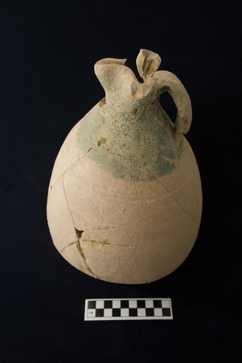
In the magnetometry survey of 2013 (see below), walls composed of materials interpretable as burned or baked bricks were identified on the south slope of the high mound. Given these results and the predominance of Middle Bronze sherds on the surface, a 10 × 10 metre trench (5065/2973) was opened in this location in 2014. Although the main occupational remains were indeed Middle Bronze in date, evidence of Islamic period occupation was found close to the site surface and primarily consisted of potsherds, as well as a complete glazed jug datable to the Early Islamic period (Fig. 17).Footnote 16
Early Islamic period jug, High Mound South Slope. Light yellow-green, fine sand, green glaze upper body and rim interior

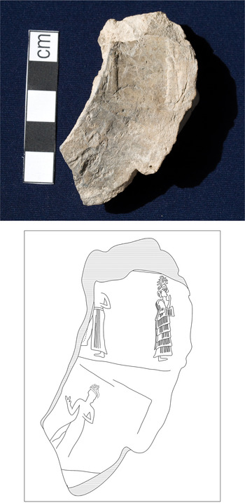
Excavations in trench 5065/2973 identified two Middle Bronze phases of occupation. The later of the two was poorly preserved and consisted of occasional fragmentary mudbrick walls and features such as a large rimless pot sunk into an outdoor surface. Deriving from this later phase is a clay jar sealing that had been impressed at least twice with an Old Babylonian cylinder seal (Fig. 18, G-1). The upper rolling preserves the so-called suppliant goddess (or Lama) facing right, wearing an ornate flounced robe and a high horned headdress. On the left is the partially preserved figure of an ascending god facing left, with a blank space left between the god and the suppliant goddess. The lower rolling preserves the blank space and most of the figure of the ascending god. The ascending posture, with one leg raised and bent at the knee, is one of the most popular during the Old Babylonian period.Footnote 17 Most often, the ascending position is used for the sun god, who holds the saw-toothed blade in his extended right arm. On the Kurd Qaburstan sealing, the god holds a weapon (not identifiable) pointing upward, with his right arm bent, a less common pose for the sun god.Footnote 18 The blank space separating the ascending god and suppliant goddess may have been intended for an inscription that was never added.Footnote 19 At Tell al-Rimah, an onyx cylinder seal preserves a similar scene but with the addition of a divine male figure behind the ascending god.Footnote 20 In the Rimah seal, the ascending god holds his right arm bent upwards, holding the “rod-and-ring” emblem. There is a blank space left for the inscription, and the seal itself may not have been finished since the feet of the secondary deities were not carved.
Old Babylonian clay jar sealing (G-1). High Mound South Slope

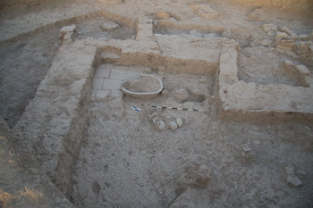
In the earlier Middle Bronze phase was mudbrick architecture and an adjacent system of baked brick drains. A large room had complete pottery vessels in situ in addition to a ceramic vat partly coated with bitumen installed next to a surface of baked bricks in the room's southeast corner (Fig. 19).
Middle Bronze room with baked brick flooring and vat, High Mound South Slope, looking southeast

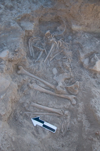
Intruding into the Middle Bronze deposits were numerous pit burials. Most were devoid of artefacts or contained, at most, a pair of simple round bronze earrings near the skull, but the burial of an adult female (Fig. 20) containing many objects suggests a first millennium b.c. date for the graves. On the upper body, perhaps originally in a bag or other container, were three stamp seals, a cylinder seal, two bronze kohl applicators,Footnote 21 a bronze fibula,Footnote 22 a carved bone object,Footnote 23 seven bronze needles found inside a bone container, and a small dark stone disk with three carved concentric circle motifs (possibly a spindle whorl).
Achaemenid period burial, High Mound South Slope

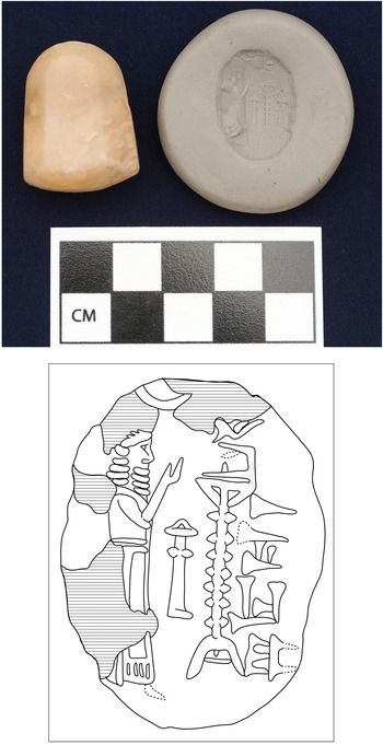
The largest stamp seal, conoid in shape and made of a brown translucent stone (chalcedony?) (Fig. 21, G-3), depicts a bare-headed worshipper standing before a stand with a symbol on top.Footnote 24 An incense burner or perhaps a spade, the symbol of Marduk, occupies the space between them, and a crescent appears above. On the right side of the impression is an inscription probably engraved after the seal imagery was carved. The inscription, readable as a mirror image after turning the seal ninety degrees, consists of the name m ku-si-iá.Footnote 25 Since this name is not attested, the reading might be amended to m ba!-si-iá, a common personal and family name from the late Assyrian into early Achaemenid periods.Footnote 26 The scene of a worshipper before an altar or divine symbol is well attested in the Neo-Babylonian period and is often found on seals of conoid and octagonal conoid shape. More unusual is the motif of the stand with a symbol on its top.Footnote 27 As the comparanda indicate, it is not uncommon for this type of Neo-Babylonian seal to occur in early Achaemenid contexts.Footnote 28 The two other stamp seals were considerably worn, but their designs seem to include a human rider on a quadruped (G-4, rectilinear conoid light yellow stone stamp seal), and a horned animal (G-6, truncated conical blue faience stamp seal).
Neo-Babylonian style stamp seal (G-3) and impression, Achaemenid period burial

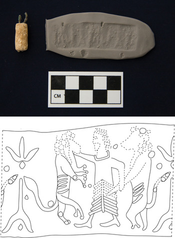
The cylinder seal (Fig. 22, G-5) was made of light yellow stone (possibly limestone), with bronze attachments on either end. Although the seal was very worn, traces of the “heroic encounter” scene of Achaemenid style seals can be discerned, with a standing male figure facing left wearing the Achaemenid court robe. He appears to stand between two upright lions that are separated by a tall thin vegetal motif. It seems that the hero holds a dagger at his side in his left hand, although he may be holding an extended leg of a lion instead. The composition of a hero with a dagger at the waist between two animals is unusual but not unattested.Footnote 29 If the objects in this grave can be used to date the other intrusive burials in the trench, the burials would belong to the period of the Achaemenid Persian empire, an important phase only minimally documented in northern Iraq (Curtis Reference Curtis, Briant and Boucharlat2005; MacGinnis Reference MacGinnis2013a).
Cylinder seal (G-5) and impression, Achaemenid period burial

Middle Bronze Remains, Lower Mound North
Because the surface pottery collection had indicated that Middle Bronze occupation was accessible below the site surface in the northern lower town, excavations in a 10 × 10 metre trench (4870/3217) in this area were initiated in 2014. The trench was located in a zone where large sherds of Middle Bronze pithoi and storage jars had been found on the site surface.
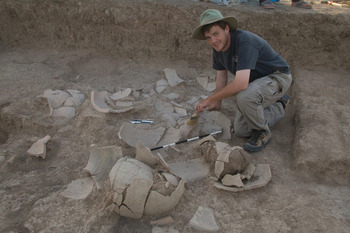
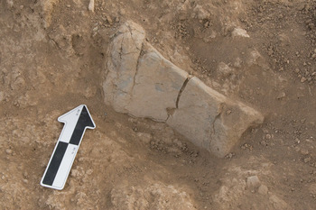
As the surface pottery indicated, the latest subsurface occupation period was Middle Bronze, with two phases identified. In the later phase, mainly attested in the western part of the trench, a drain consisting of ceramic pipes was associated with a surface of potsherds and pebbles. In the earlier phase was an occupation with several rooms and outdoor surfaces. The mudbrick walls of the rooms were difficult to observe—only just above floor level could one discern grey-brown walls with grey bricks demarcating rooms containing reddish-brown soil.Footnote 30 Since two of the rooms had numerous pottery vessels lying broken in situ, it would appear that the area had been abandoned abruptly. Many vessels were large jars or kraters, indicating the importance of storage in this area (Fig. 23). Food preparation also must have taken place in this location, given the presence of four clay ovens, a large ceramic vat, and numerous grinding stones. Several of the grinding stones and an andiron were composed of “synthetic basalt,” ceramic slag produced to replicate basalt, also identified in Old Babylonian period southern Mesopotamia (Fig. 24) (Stone et al. Reference Stone, Lindsley, Pigott, Harbottle and Ford1998). Presumably this material was produced because of the rarity of basalt in Mesopotamia.
Smashed large ceramic vessels in situ, Middle Bronze, Lower Town North, looking east

“Synthetic basalt” andiron(?) in situ, Middle Bronze, Lower Town North

Islamic Period Remains, Lower Mound South and West
Among the notable features on the CORONA satellite photographs of Kurd Qaburstan are white masses observable on the lower town, south of the high mound. Such features have been interpreted as anthrosols indicative of substantial mudbrick architecture (Ur et al. Reference Ur, de Jong, Giraud, Osborne and MacGinnis2013). In order to test this interpretation, a 6 × 10 metre trench (5260/2846) was excavated on the lower mound south in an area characterized by white formations on the CORONA images.
Immediately below the present-day surface was poorly-preserved mudbrick architecture associated with Islamic period pottery. In order to document the occupational history of the area and to ascertain whether pre-Islamic deposits were present, a one-metre wide test trench was excavated against the south balk to a depth of 2.8 metres. The deposits identified in the test trench were associated exclusively with Islamic era ceramics. Most prominent in the exposed remains was a wall of baked bricks preserved to eleven courses that protruded from the west balk, the extant top of which was 1.4 metres underneath the present-day mound surface. The ceramic remains (Schwartz Reference Schwartz, Kopanias and MacGinnis2016: fig. 13) date to the Middle Islamic period, approximately thirteenth to fourteenth centuries a.d., and include Sgraffiato Ware, Turquoise Glazed Ware, and pottery with black painted decoration under a transparent turquoise glaze (Wilkinson and Tucker Reference Wilkinson and Tucker1995: 220, fig. 79; Vezzoli Reference Vezzoli2008; Ur Reference Ur2010b: 295–96).Footnote 31 Also found were handmade flat-based plates (see Pappalardo Reference Pappalardo, Matthews and Curtis2012: 649) and fragments of glass bracelets. The identification of substantial baked brick architecture in this trench supports the inference, made from CORONA images, of significant structures in the area, although one might question whether architecture at a depth of 1.4 metres would be detected by CORONA photographs.
Since a white formation visible on the CORONA photographs in the western lower town was suggestive of a single large building, a 6 × 10 metre trench (4844/2806) was opened in this area. The latest occupation phase included a cobbled surface c. 2.5 × 2.5 metres in area, associated with Islamic era ceramics.Footnote 32 To determine the depth of Islamic occupation, a 1-metre wide test trench was excavated against the south balk. Deposits in the 2.5 metre deep test trench primarily yielded Islamic pottery, except for a small number of second millennium b.c. sherds found immediately above the limit of excavation. There was no significant architecture except for a small circular hearth composed of stone cobbles. Therefore, the results from trench 4844/2806 supply no evidence of the large building inferred from the CORONA photographs. It is possible, however, that the excavations were concentrated in an open area inside a large architectural unit.
A Middle Bronze Age City Wall
In order to confirm the existence of the city wall and ascertain its date, two trenches were opened in locations where the wall's presence was inferred. On the west, excavations in trench 4666/3076 (6 × 10 metres) encountered homogeneous red-brown hard soil with lime inclusions below the present-day surface, without associated artefacts. For diachronic investigation, a test trench one metre wide reaching a depth of 2.2 metres was excavated along the ten metre-long south balk and extended an additional 4.5 metres to the east. Although homogeneous soil without evidence of stratigraphy was encountered in the step trench, there was a significant difference between the outer (western) and inner (eastern) parts of the trench. In the west was an absence of artefactual or architectural features, but the east had Middle Bronze ceramics, a fragmentary terracotta mould-made plaque depicting a standing female wearing a collar and holding her breasts (Schwartz Reference Schwartz, Kopanias and MacGinnis2016: fig. 15), a round clay oven, and a large circular limestone door socket (38 × 37 × 28 centimetres). We therefore propose that the outer (western) segment of the trench included part of a city wall composed of packed mudFootnote 33 or of mudbricks that had fused together due to local geomorphological circumstances,Footnote 34 while the inner (eastern) area had deposits that accumulated against the interior face of the city wall. Additional corroborating information on the existence and character of the city wall was obtained in the geophysical survey (see below).
Comparable results were derived from a trench in the northwest measuring 20 × 1 metres (units 4946/3454 and 4946/3444) and reaching a depth of 2.3 metres. In this trench, a similar red-brown hard soil matrix with lime inclusions was identified. The outer (northern) part of the trench was nearly void of artefactual materialsFootnote 35 while the inner (southern) segment had Middle Bronze Age ceramics and an east-west oriented row of baked bricks preserved one course high. Again, we hypothesize that the outer (northern) part of the trench included part of a city wall composed either of packed mud or of mudbricks that had congealed into a uniform mass, while the inner (southern) part comprised artefactual and architectural materials deposited inside the wall.
Pottery
The Middle Bronze Assemblage
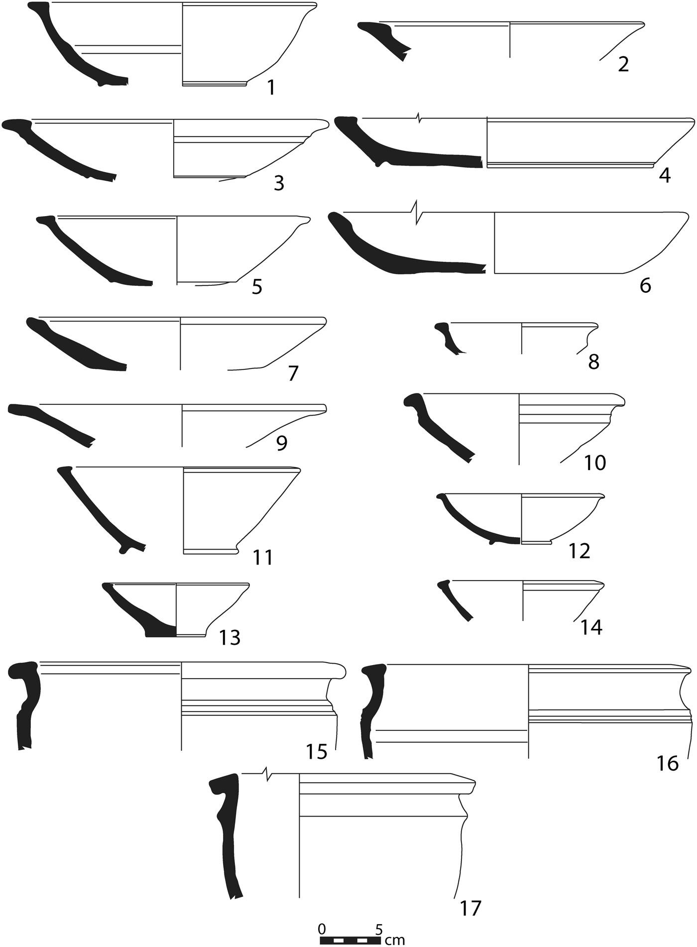
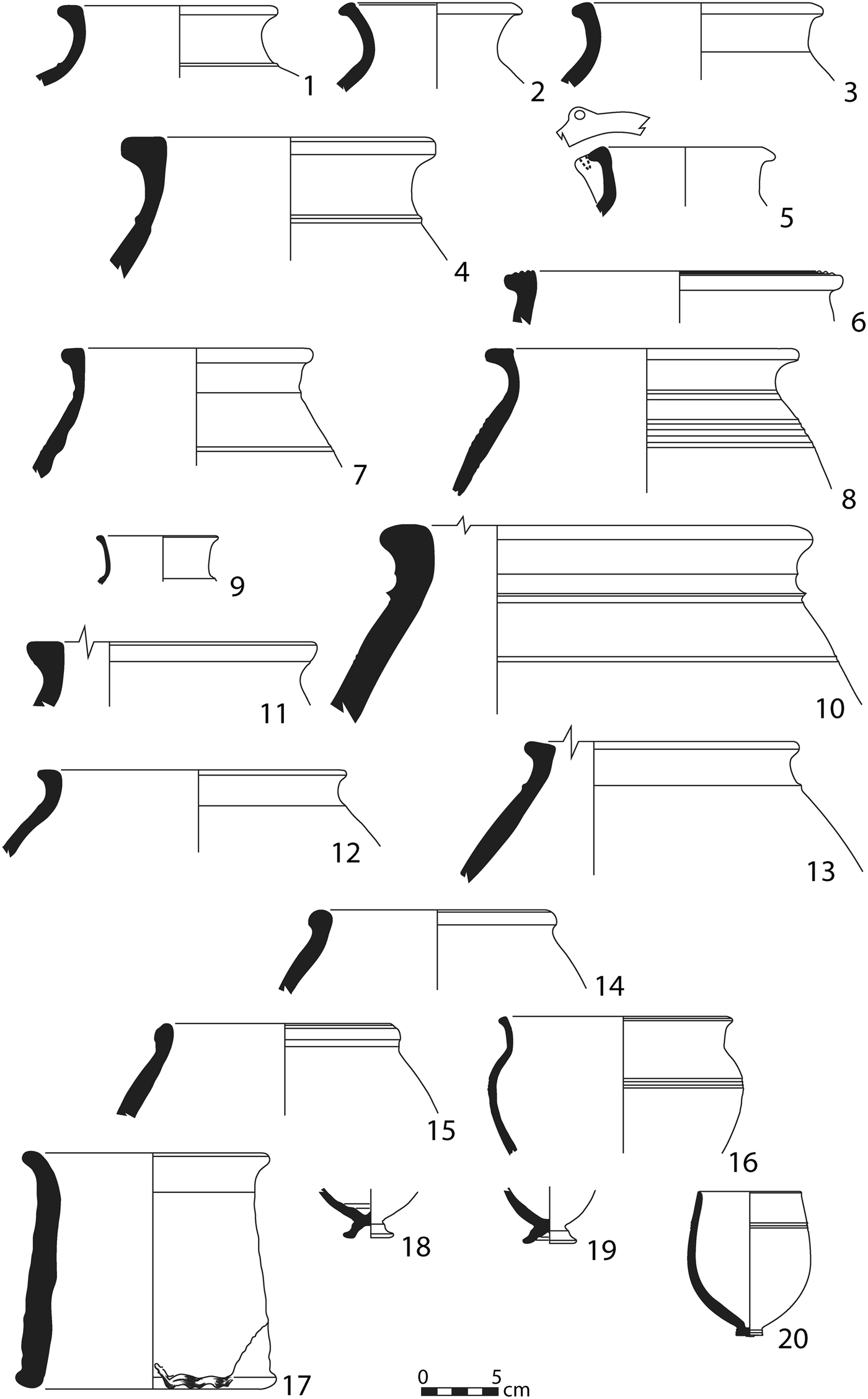
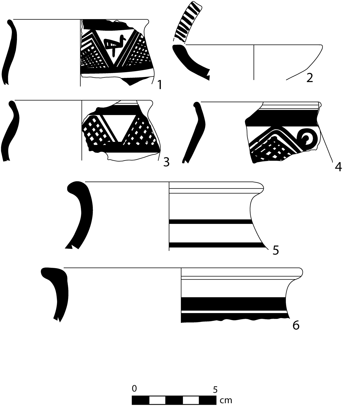
With the exception of cooking ware and decorated fine ware vessels, the Middle Bronze pottery from Kurd Qaburstan was characterized by light yellow or, more rarely, pinkish-brown clay with vegetal inclusions. Attested bowl shapes (Fig. 25) include examples with ledge or flat-topped rims (Fig. 25: 1–5, 9), often with channel bases (Fig. 25: 4)Footnote 36 ; bowls with interior thickening at the rim (Fig. 25: 6)Footnote 37 ; carinated bowls with everted rims (Fig. 25: 8, 10)Footnote 38 ; and bowls with slightly inturned rims (Fig. 25: 11, 14).Footnote 39 Ledge rims are also found on pots and jars (Fig. 25: 15, 17; Fig. 26: 4, 5, 7, 8)Footnote 40 , while other jar types include examples with tall necks and everted rounded rims (Fig. 26: 2–3)Footnote 41 and rims triangular in section (Fig. 26: 11). Well-represented among the jars are examples with a horizontal applied band at the bottom of the neck (Fig. 26: 1, 4, 10, 13)Footnote 42 , and a distinctive type among the pots is an example with a set of horizontal ridges on the shoulder (Fig. 25: 15–16).Footnote 43 Ledge rim bowls and jars sometimes have grooving on top of the rim (Fig. 26: 6),Footnote 44 and jars sometimes have perforated vertical lugs at the rim (Fig. 26: 5).Footnote 45 Combed decoration is occasionally evident, and examples of painted Khabur ware of the “classic” period are characteristic of the assemblage (Fig. 27).Footnote 46 A common cooking vessel type consists of a holemouth jar or pot of pink-brown clay with a large bead rim (Fig. 26: 14, 15) or an everted rim (Fig. 26: 12). Also found were occasional examples of sherds with crude bitumen painted motifs. Parallels for the Middle Bronze assemblage at Kurd Qaburstan can be noted from Middle Bronze/Old Babylonian levels at Tell al-Rimah on the Sinjar plain, Tell Rijim in the Tigris Eski Mosul salvage region, Khirbet ed-Diniye (Haradum) on the Iraqi middle Euphrates, and Tell Leilan in the upper Khabur.
Middle Bronze ceramics. Medium vegetal inclusions unless otherwise specified. 25.1 KQ 14 5065/2973–020. Light yellow, no visible inclusions. 25.2 KQ 14 4870/3217–066. Black, medium vegetal and fine white sand inclusions, burnished exterior/interior. 25.3 KQ 14 5065/2973–042. Light yellow, no visible inclusions. 25.4 KQ 14 4870/3217–067. Pink-brown. 25.5 KQ 14 5065/2973–058. Light yellow, fine/medium vegetal inclusions.5. 25.6 KQ 14 4870/3217–071. Pink-brown. 25.7 KQ 14 4870/3217–046. Light yellow. 25.8 KQ 14 5065/2973–005. Light yellow exterior/interior, brown core. 25.9 KQ 14 5065/2973–085. Light yellow exterior/interior, light brown core. 25.10 KQ 14 4870/3217–038. Light yellow. 25.11 KQ 14 4870/3217–058. Light yellow, no visible inclusions. 25.12 KQ 14 4870/3217–058. Light yellow, no visible inclusions. 25.13 KQ 14 4870/3217–046. Light yellow exterior/interior, core pink-brown, medium vegetal and fine white sand inclusions. 25.14 KQ 14 4870/3217–037. Pink-brown, no visible inclusions. 25.15 KQ 14 5065/2973–059. Light yellow/green. 25.16 KQ 14 4870/3217–058. Light yellow. 25.17 KQ 14 4870/3217–033. Light yellow exterior/interior, light brown core. Bitumen traces on upper exterior

Middle Bronze ceramics. Medium vegetal inclusions unless otherwise specified. 26.1 KQ 14 5065/2973–021. Light brown. 26.2 KQ 14 5065/2973–061. Light yellow/green. 26.3 KQ 14 5065/2973–005. Light yellow, fine sand inclusions. 26. 4 KQ 14 5065/2973–015. Light yellow. 26.5 KQ 14 5065/2973–086. Light yellow. 26.6 KQ 14 5065/2973–005. Pink brown, no visible inclusion. 26.7 KQ 14 5065/2973–048. Light yellow. 26.8 KQ 14 5065/2973–123. Light yellow. 26.9 KQ 14 5065/2973–054. Light yellow/brown, no visible inclusions. 26.10 KQ 14 5065/2973–058. Light yellow. 26.11 KQ 14 5065/2973–073. Light yellow. 26.12 KQ 14 4870/3217–046. Pink brown, coarse/medium/fine vegetal and shell inclusions. 26.13 KQ 14 5065/2973–053. Light yellow. 26.14 KQ 14 5065/2973–056. Light brown, medium vegetal, medium shell, fine sand inclusions. 26.15 KQ 14 5065/2973–015. Light brown exterior, light yellow interior, coarse sand and shell inclusions. 26.16 KQ 14 4870/3217–070. Light yellow. 26.17 KQ 14 5065/2973–059. Light brown. 26.18 KQ 14 5065/2973–036. Light yellow, no visible inclusions. 26.19 KQ 14 4870/3217–037. Light yellow, no visible inclusions. 26.20 KQ 14 4870/3217–045. Light yellow, no visible inclusions

Middle Bronze painted ceramics. 27.1 KQ 14 4870/3217–061. Light brown, no visible inclusions, brown paint. 27.2 KQ 14 4870/3217–037. Light brown, no visible inclusions, red paint. 27.3 KQ 14 5065/2973–023. Light yellow slip exterior/interior, light brown core, fine vegetal inclusions, red–brown paint. 27.4 KQ 14 5065/2973–045. Light yellow-brown, no visible inclusions, red paint. 27.5 KQ 14 5065/2973–060. Light brown, brown paint, no visible inclusions. 27.6 KQ 14 4870/3217–050. Light yellow exterior/interior, red-brown core, medium vegetal inclusions, red brown paint

In the later Middle Bronze phase on the Lower Mound North, two elements in the ceramic drain were “piecrust” potstands. Although this type is often thought to be restricted to the Mittani period (Pfälzner Reference Pfälzner, al-Maqdissi, Matoïan and Nicolle2007), excavations at Tell Rijim in the Eski Mosul salvage area revealed many examples from Middle Bronze levels (Koliński Reference Koliński2000), and attestations at Assur date as far back as the later third millennium b.c. (Bär Reference Bär2003: Tafeln 88–91). Other examples of piecrust potstand sherds were frequently found in Middle Bronze contexts in the Kurd Qaburstan Lower Mound North and the High Mound South Slope (Fig. 26: 17). Apparently, piecrust potstands were in use long before the Late Bronze Age in the upper Tigris region.
The Late Bronze Assemblage
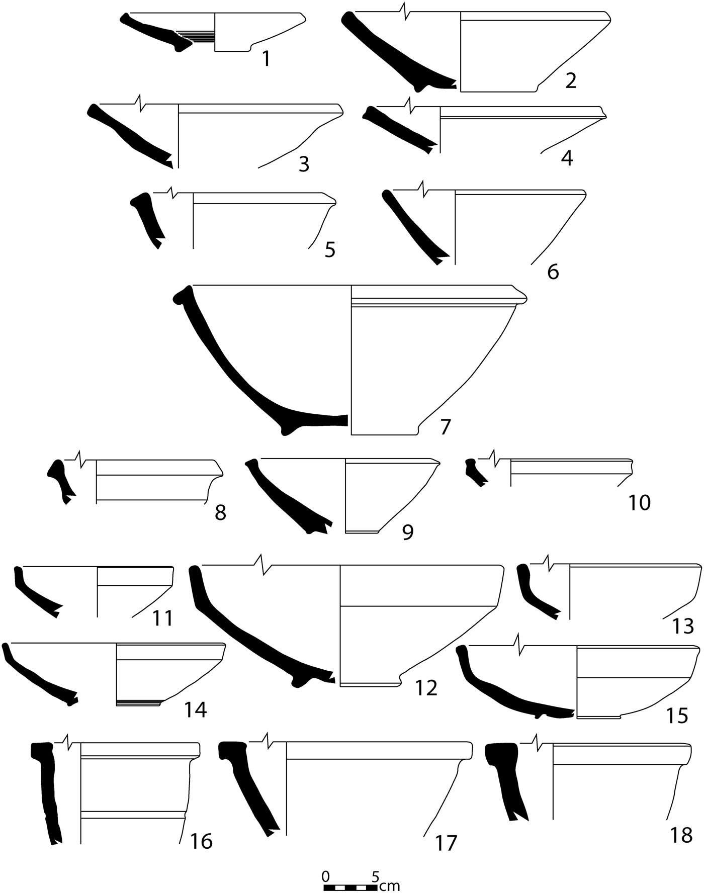
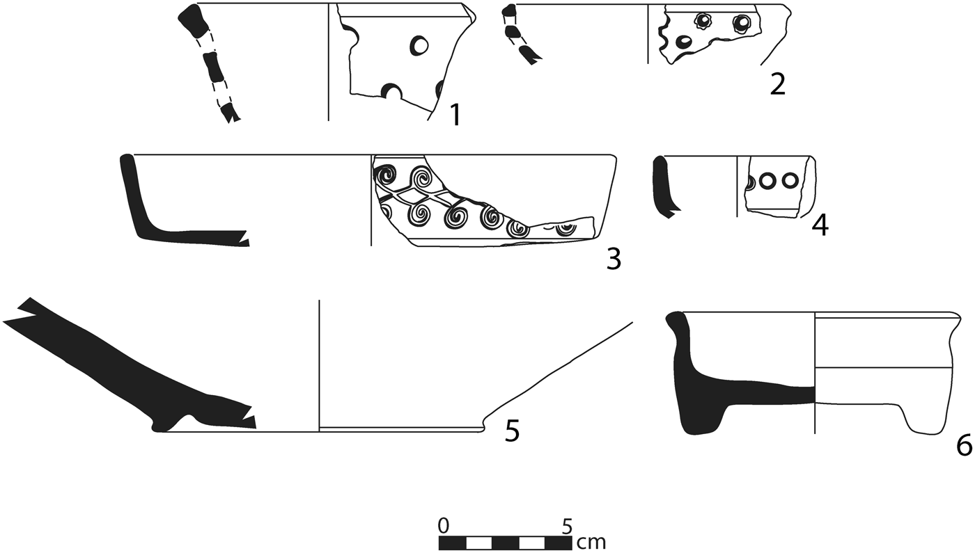
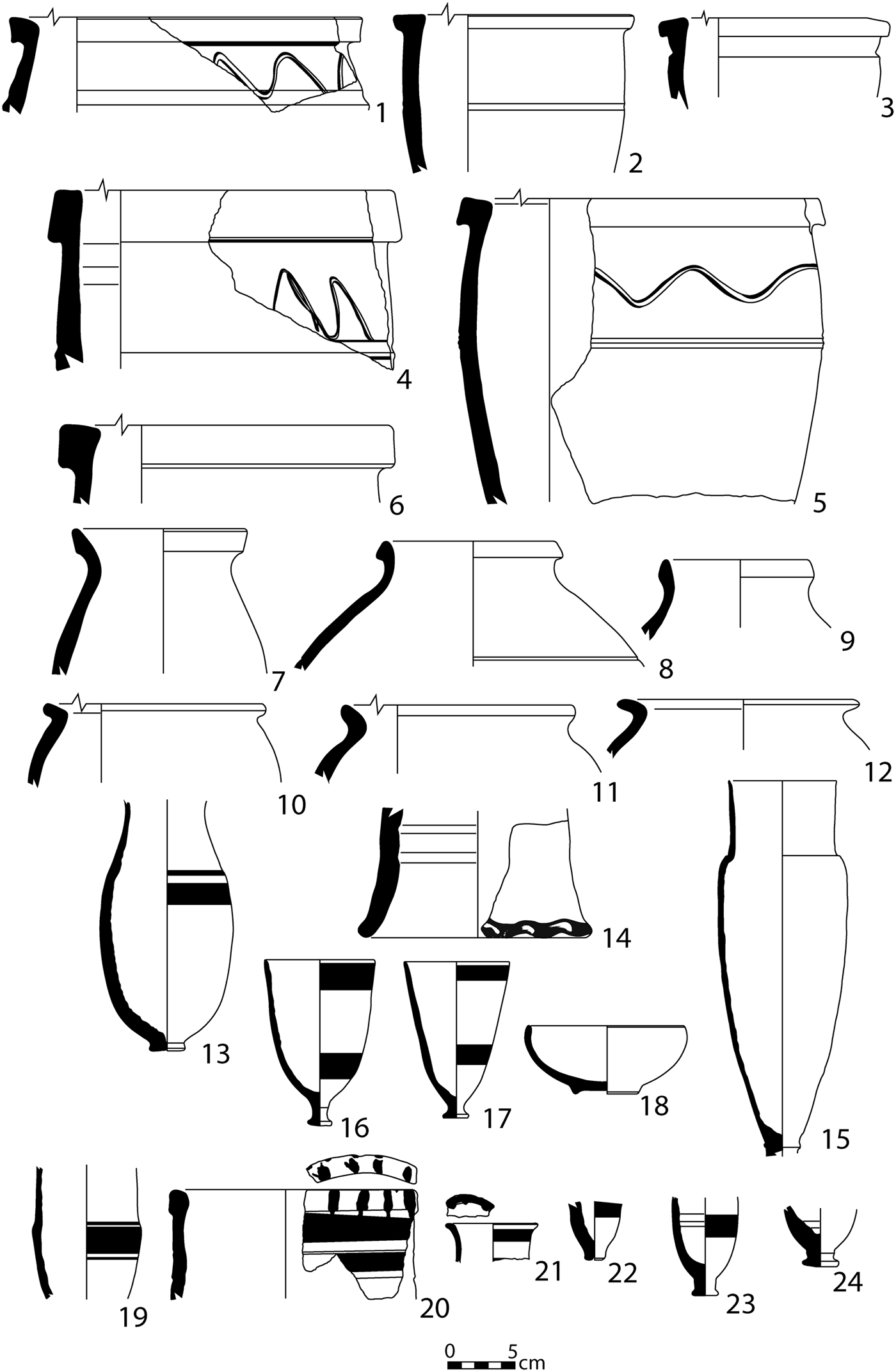
Like the MB pottery, the LB vessels at Kurd Qaburstan usually had light yellow or pinkish-brown clay with vegetal inclusions, except for cooking ware and decorated fine ware. Among the well-attested ceramic types (Figs. 28–30) are shallow bowls or plates with bevelled or simple rims (Fig. 28: 1–4, 6),Footnote 47 bowls with rims triangular in section (Fig. 28: 5, 7–9),Footnote 48 bowls with square, block rims (Fig. 28: 16–18), and carinated bowls with vertical upper bodies and simple rims (Fig. 28: 11–14),Footnote 49 sometimes in grey burnished ware (Fig. 28: 15).Footnote 50 Jars and kraters with square, block rims were common (Fig. 30: 1, 4–6),Footnote 51 as were jars with tall, thickened rims (Fig. 30: 7, 9). Piecrust pot stand sherds (Fig. 30: 14) and strainers were also abundant (Fig. 29: 1–2). Among the cooking pot sherds, often grey or black burnished, were examples with angular flaring rims (Fig. 30: 10–12),Footnote 52 everted bevelled rims, and short everted rims. Many or most of the types are well-known from other Mittani period assemblages in northern Iraq (e.g. Nuzi, Tell al-Rimah, Nemrik) and north-eastern Syria (e.g. Tell Brak, Tell Barri).
Late Bronze ceramics. Light yellow, medium vegetal inclusions unless otherwise specified. 28.1 KQ 5144/3044–112. Light yellow-green. 28.2 KQ 5155/3044–019. Light yellow-brown. 28.3 KQ 5088/3116–185. 28.4 KQ 5155/3044–081. 28.5 KQ 5144/3044–103. 28.6 KQ 5155/3044–050. 28.7 KQ 5155/3044–095. Light yellow exterior, light brown interior. 28.8 KQ 5088/3116–117. 28.9 KQ 5155/3044–110. Light yellow-brown, medium vegetal and lime inclusions. 28.10 KQ 5088/3116–124. 28.11 KQ 5088/3116–117. 28.12 KQ 5134/3044–012. Light yellow exterior/interior, red-brown core, medium vegetal and fine sand inclusions. 28.13 KQ 5155/3044–014. Light yellow exterior/interior, light brown core. 28.14 KQ 5155/3044–039. 28.15 KQ 5155/3044–053. Dark grey, fine white sand, burnished. 28.16 KQ 5155/3044–078. Light brown. 28.17 KQ 5155/3044–010. Light yellow exterior/interior, light brown core, coarse/dense vegetal inclusions. 28.18 KQ 5155/3044–043

Late Bronze ceramics. 29.1 KQ 5088/3116–134. Light yellow, medium vegetal inclusions. 29.2 KQ 5088/3116–201. Light brown, no visible inclusions. 29.3 KQ 5088/3116–225. Black, no visible inclusions, incised, burnished. 29.4 KQ 5155/3044–069. Brown–grey, no visible inclusions, stamped. 29.5 KQ 5155/3044–035. Light yellow-brown, medium vegetal inclusions. 29.6 KQ 5144/3044–140. Grey, fine white sand, exterior burnished

Late Bronze ceramics. Light yellow, medium vegetal inclusions unless otherwise specified. 30.1 KQ 5144/3044–021. 30.2 KQ 5144/3044–103. Light brown. 30.3 KQ 5144/3044–112. 30.4 KQ 5088/3116–100. Incised. 30.5 KQ 5144/3044–123. Incised. 30.6 KQ 5088/3116–194. 30.7 KQ 5088/3116–180. Light yellow exterior/interior, light brown core. 30.8 KQ 5144/3044–144. 30.9 KQ 5155/3044–036. 30.10 KQ 5155/3044–002. Dark grey, fine sand. 30.11 KQ 5155/3044–031. Dark brown to black, fine white sand. 30.12 KQ 5155/3044–044. Dark grey, medium white sand. 30.13 KQ 5155/3044–086. Light yellow exterior/interior, light brown core, no visible inclusions, red-brown paint, interior ridges. 30.14 KQ 5088/3116–190. 30.15 KQ 5144/3044–106 (Burial 2). Light yellow, no visible inclusions, interior ridges. Base broken. 30.16 KQ 5155/3044–011 (Burial 1). Light brown, coarse lime inclusions, red-brown paint, interior ridges. 30.17 KQ 5155/3044–043. Light brown-yellow, no visible inclusions, black-brown paint. 30.18 KQ 5144/3044–106 (Burial 2). Glazed ceramic, exterior/interior blue-green. 30.19 KQ 5155/3044–052. Light yellow, no visible inclusions, red-brown paint, interior ridges. 30.20 KQ 5088/3116–217 and 227. Light brown, no visible inclusions, brown paint. 30.21 KQ 5088/3116–194. Light brown-grey, fine vegetal inclusions, dark brown paint. 30.22 KQ 5088/3116–190. Light yellow, no visible inclusions, brown paint. 30.23 KQ 5088/3116–153. Light yellow, no visible inclusions, black paint. 30.24 KQ 5088/3116–120

Examples of Younger Khabur Ware (Pfälzner Reference Pfälzner, al-Maqdissi, Matoïan and Nicolle2007) were frequently attested, deriving from fine, thin-walled goblets with pedestal or button bases and painted horizontal stripes (Fig. 30: 13, 16–17, 19, 22–23). Rim and body sherds likely to derive from “grain measures” were also noted, a type consisting of beakers with low carination, painted horizontal stripes on the vessel body, and/or painted stripes atop the rim (Fig. 30: 20–21). Undecorated grey/black burnished bowl sherds were found with some frequency (Fig. 29: 6),Footnote 53 and occasional fragments of White Paste Inlay Ware bowls (Pfälzner Reference Pfälzner, al-Maqdissi, Matoïan and Nicolle2007) were noted, the latter grey/black burnished with incised, impressed, and infilled decoration (Fig. 29: 3–4). Despite extensive excavation of Mittani period strata, only two sherds of Nuzi Ware were recognized, although some dark-on-light painted sherds had motifs familiar from Nuzi Ware (Schwartz Reference Schwartz, Kopanias and MacGinnis2016: fig. 10). Red-edged bowls, a common Mittani diagnostic, were only represented by one sherd from the latest phase (phase 1) on the High Mound East (Oates, Oates, and McDonald Reference Oates, Oates and McDonald1997: 73; Postgate, Oates, and Oates Reference Postgate, Oates and Oates1997: 56; Pfälzner Reference Pfälzner, al-Maqdissi, Matoïan and Nicolle2007).
Since grey burnished bowls and White Paste Inlay Ware are identified by Pfälzner as characteristic of his early Mittani phase (Middle Jezirah IA) and Red-edged bowls are assigned to later Mittani (Middle Jezirah IB), it is possible that the Late Bronze phases excavated on the high mound primarily date to the earlier part of the Mittani period.
Geophysical Survey
Under the right conditions, the best approach to recording broad spatial patterns quickly and efficiently at archaeological sites is the application of geophysics. This is especially true at urban sites, where geophysics surveys provide large-scale data that would otherwise require a lifetime of excavation. Many successful surveys demonstrate the value of geophysics in the study of Bronze Age Mesopotamian cities (Peregrine Reference Peregrine1996; Matney Reference Matney and Hopkins2002; Pfälzner et al. Reference Pfälzner, Wissing and Hubner2004; Meyer Reference Meyer, Butterlin, Lebeau, Monchambert, Montero Fenollós and Muller2006; Castel and Peltenburg Reference Castel and Peltenburg2007; Creekmore Reference Creekmore2010; Nishimura Reference Nishimura, Creekmore and Fisher2014; Yates Reference Yates2014: 176–81). During the 2013–2014 seasons at Kurd Qaburstan, the geophysics team collected ground-penetrating radar, resistivity, conductivity, and magnetometry data. The purpose of this work was to identify buried remains including architecture, roads or paths, fortifications, pyrotechnic installations, and other features to be expected at a large urban site. In these investigations, urban form and planning as well as the materials of construction were subjects of study. Of the methods applied, magnetometry was by far the most successful and was expanded to cover a third of the city. Other methods were tested in limited areas to illuminate the magnetometry data. In the following sections we review highlights from each method except ground-penetrating radar, which did not produce useful results.
Magnetometry
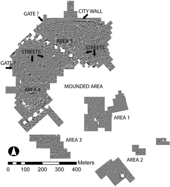
During the 2013–2014 seasons, the team collected magnetometry data covering thirty-one hectares in five areas across the site that are gradually merging as the survey expands (Fig. 31). All parts of the site were tested except for the north-eastern quarter, where irrigated or mature crops prevented access. For this work, we used a Bartington Grad 601–2 magnetic gradiometer with effective sensitivity of 0.03 nT/m. Data were collected at 0.5 × 0.125 metre resolution by hand-carrying the instrument in measured grids. Most of the features recorded by this instrument were probably located at a maximum of one metre depth below the ground surface.
Magnetometry data for the entire site with selected features marked (clipped to +/–5 nt; black is positive, white is negative)

Preliminary results indicate that the remains detected below the site surface in the western lower town, including areas to the north, northwest, and west of the central high mounds, were occupied for a single time period. We arrive at this conclusion because of the continuity of streets and architecture visible in the data across nineteen hectares, an area that probably extends at least another five hectares to the northeast, where data could not be collected due to irrigation activities. Had this area contained differentiated spaces of multi-period settlement, we would expect features to be less continuous, with the caveat that streets can endure for long periods of time. Given the results of surface collection and excavation, we conclude the occupation period in question is the Middle Bronze Age.
In contrast, the area south and east of the mounded centre yielded cluttered data in which coherent architecture and features are difficult to discern. It is our impression that this clutter is caused by the lack of a single stratum with remains from only one period. Instead, the data show superimposed remains from different periods, a situation that makes it difficult to trace linear features or to associate isolated features with architecture. Excavations in Areas 1 and 2 support this interpretation, since MB and Islamic contexts were uncovered in Area 1 and Islamic contexts in Areas 2 and 3. Notably, the southern part of Area 2 contains clear linear features that are most likely to be walls, suggesting that the south-eastern part of the site may also be single period; further work might be expected uncover large-scale patterns similar to those in the western lower town.
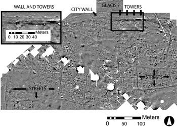
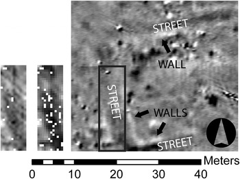
Here we briefly review the key characteristics of the features revealed in the clearest area of the magnetogram in the western third of the city.Footnote 54 Note that all measurements listed contain a range of error as high as fifty centimetres. Visible as 3.3–6.85 metre linear features are main streets that extend and connect throughout the western part of the city, forming large blocks with dense architecture and occasional open spaces (Figs. 31–33). Skirting the central mounded area is one example of a main street, and others branch to the north or west from this inner circuit towards an additional main street between the inner street and the city wall. Some secondary streets are visible within the main blocks, but these are often difficult to discern. Along the city wall, street patterns and features suggest that there may be gates in at least two locations (Fig. 31).
Magnetometry data for the north-western part of the site with selected features marked (clipped to +/–5 nt; black is positive, white is negative)

Resistivity data (L), magnetometry data (R), Area 4. Resistivity area is outlined on the magnetogram. A high and low contrast version of the resistance data are provided, showing the street as higher values than the walls bordering it. Magnetogram is clipped to +/–5 nt, resistivity data is clipped to 15 /–13 ohm (left) and 8 / –11 ohm (right). Black is positive, white is negative in both data sets

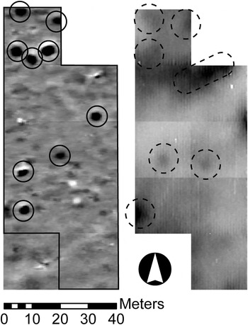
Although extensive ground truthing excavations have not been conducted, limited exposures confirm that the architectural features seen in the magnetograms are made from unfired mudbrick. The use of stone in architecture is very limited in excavated areas. Since most walls in the magnetogram have a low magnetism that is consistent with unfired mudbrick walls excavated in the lower town, it is likely that the majority of the city is built from this material. Most walls detected in the magnetometry data are probably 0.5–1 metre thick. While some structures are small and are likely to be houses, sizeable buildings with thick walls could be large residences or special-use structures. Associated features include hearths, packed pebble and earth floors, baked brick basins, and fired ceramic drains. Isolated areas of dipolar values (strong black/white spots in magnetogram figures; see especially Fig. 34) may source to pyrotechnic installations or kiln-fired bricks. Both types of entities are known from the excavations, with the latter serving to line water features or drains.
Magnetometry data (L) and 1 m coil conductivity data (R) from Area 3. Conductivity area is outlined on the magnetogram. Magnetometry data (clipped to +/- 5nt) shows possible pits and pyrotechnic features (circled). Conductivity data (dashed circles; clipped to + 30 / +9 mS/m) shows isolated features, some of which correspond to or are located adjacent to magnetometry features. Black is positive, white is negative or low values in both data sets

Perhaps the most striking feature identified by our survey is the city wall, which is seen within the mounded ring around the site both in the western and northern areas (Figs. 31–32). In the magnetogram, the wall ranges in thickness from 3.3 metres in the west to 5.3–7.6 metres in the north. The northern wall contains bastions set 18–22 metres apart. These features are similar to those of the city wall of Qabra depicted on the victory stele of Daduša (Ismail and Cavigneaux Reference Ismail and Cavigneaux2003). On the exterior of the wall is evidence of a possible glacis sixteen metres thick made of soil. Although the city wall in the north was sectioned by a trench in units 4946/3454 and 4946/3444 (see above), this effort failed to identify individual bricks. Nonetheless, the wall is very clear in the magnetometry data.
Resistivity
The team collected 2,500 square metres of resistance data in four separate areas, using a Geoscan RM85 Resistance Meter System set up in a 0.5 metre twin array that records data up to 0.5 metre depth. Despite relatively cool weather and occasional rain showers, which are advantageous for resistance data collection, it was difficult to record good values. The main challenges were presented by soil that was both very hard and dry, making it difficult to insert the probes and overcome contact resistance. To mitigate these problems we pre-made the probe holes with an iron frame, poured a cup of water into each hole, and collected data ten to twenty minutes later, following the method of Matney and Donkin (Reference Matney and Donkin2006: 23). This effort produced results that parallel the magnetometry data but with less detail. For example, the results indicated a street as an area of relatively high resistance, and walls bordering the street appeared as low resistance areas (Fig. 33). This outcome suggests that the street consists of compacted materials that do not retain significant moisture, whereas the homogeneous mudbrick walls retain relatively more moisture than the street. Subsequent limited attempts with this time-consuming technique produced poor-contrast data that were much less informative than the magnetometry. Nonetheless, this method indicates that in the tested areas architecture and features are located within 0.5 metre of the ground surface.
Conductivity
Using a Geonics EM38-MK2 conductivity meter, the team collected 12,400 square metres of data. This instrument collects four sets of data, simultaneously recording conductivity and magnetic susceptibility measurements for one metre and 0.5 metre spaced coils reaching depths of up to 0.75 metres and 1.5 metres from the ground surface. Although the magnetic susceptibility data do not show sufficient contrast in values to be useful, the conductivity data provide evidence of features. The most useful results derived from Area 3, where magnetometry data revealed several features that could be interpreted as potential pits or pyrotechnic features but also could be understood as large ferrous objects. Due to the conductivity results, we may rule out the possibility of ferrous objects, because they do not show highly conductive values at the location of any of the features, a result one would expect if there were metal debris. Instead, there are areas of slightly higher conductivity that may mark pits or moisture “containers” such as hearths or pavements (Fig. 34).
Discussion
The geophysics surveys determined that magnetometry is the best method to employ at Kurd Qaburstan because it can cover large areas relatively quickly and identify a wide range of features with clarity. Other methods such as resistance and conductivity are useful for investigating specific features observed in magnetometry data but are time consuming and fail to resolve features with clarity. Although data from the central portion of the site are very cluttered, it is hoped that better results may be obtained in the lower town towards the east.
In the western portion of the city, the data show a dense occupation with structures arranged within a complex pattern of main streets. The magnetometry features in this area suggests that they are located in a single stratum and date to a single period. On the edge of the settlement, a city wall with towers and a possible glacis provided protection and boundaries. Entry to the city may have been through gates to the north and west. While the street pattern and organization of architecture does not indicate rigid formal planning, it is not without order. Thus it is likely that Kurd Qaburstan, like other Bronze Age cities in Mesopotamia, developed through a mix of low-, mid-, and high-level planning in which different societal groups shaped portions of the city through individual or collective action (Creekmore Reference Creekmore, Creekmore and Fisher2014).
Faunal Analysis
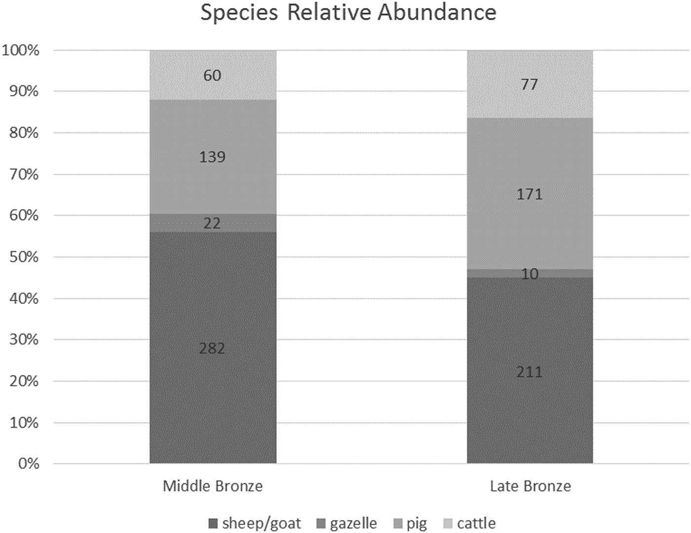
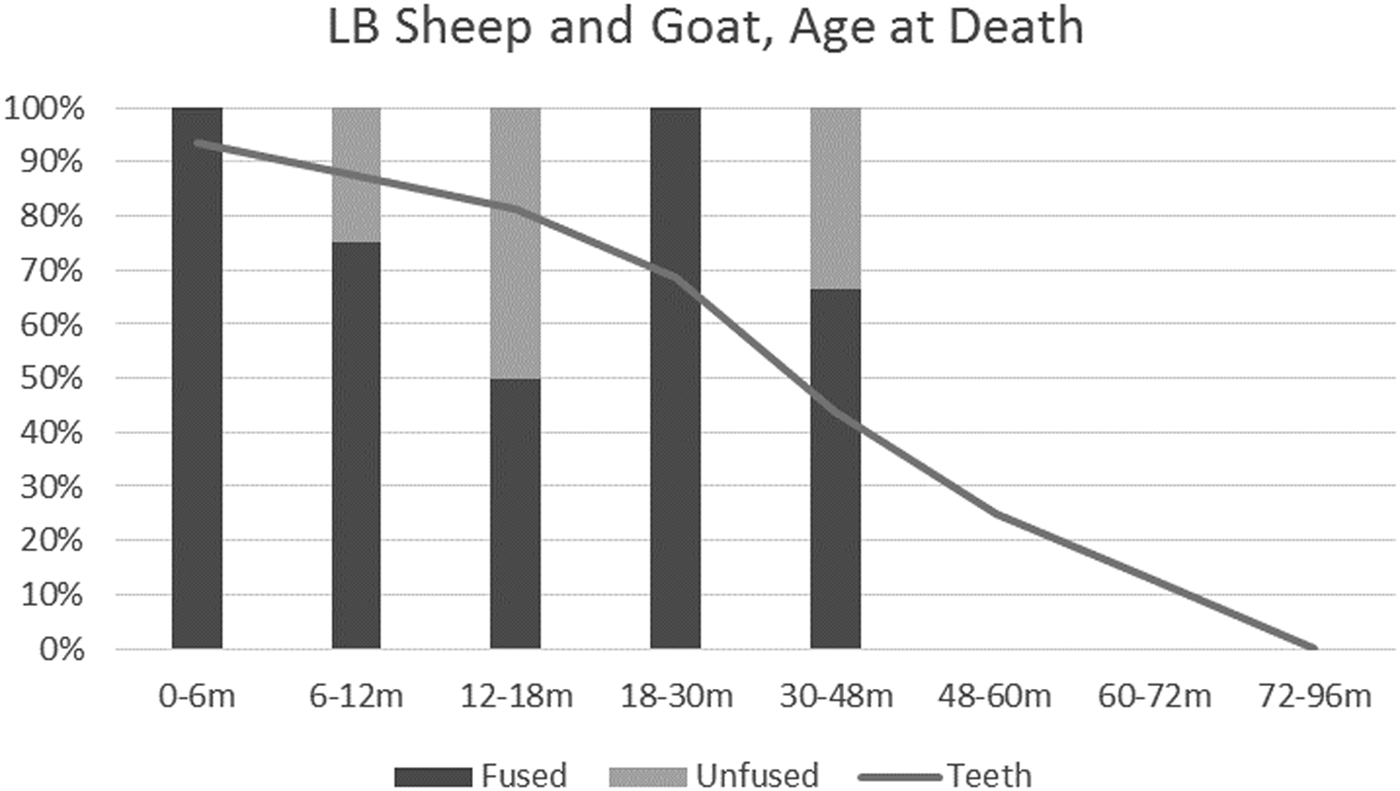
Animal bones from Kurd Qaburstan were analyzed in the field by Jill Weber and are subject to ongoing study. The bone sample discussed here stems from the excavations on the High Mound East (Late Bronze, trenches 5133/3044, 5144/3044, and 5155/3044), High Mound North (Late Bronze, trench 5088/3116), High Mound South Slope (Middle Bronze, trench 5065/2973), and Lower Town North (Middle Bronze, trench 4870/3217). Of the 2,454 individual specimens (bones independent of each other) examined, 1,268 derived from MB levels and 1,186 from LB. In both periods and in all locales, goat, sheep, pig, and cattle predominated, in that order of relative abundance (Fig. 35). Smaller quantities of dog, equid, and gazelle were also recovered, while hare, fox, bird, reptile, rodent, and fish were identified in negligible quantity.
Relative abundance of major animals

Middle Bronze Contexts
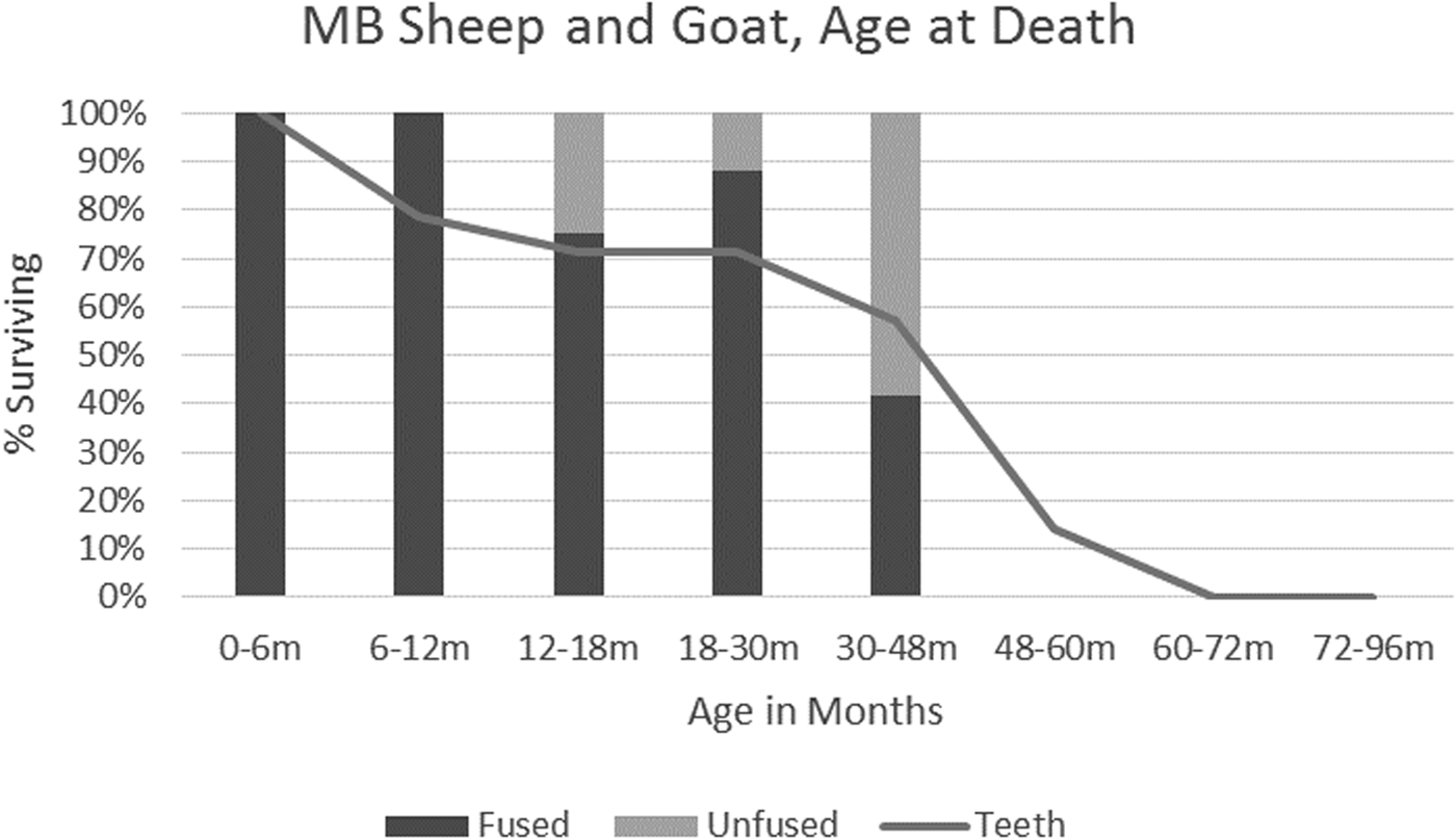
Although the two MB trenches differed from each other in both location and context, they yielded very similar animal remains. Each contained over fifty percent sheep and goat bones, followed by pig, then cattle, and with gazelle, dog, and donkey each found in only two to three percent relative abundance. However, one major difference between the two trenches is the relative number of goat to sheep bones identified. In the proposed food preparation area on the Lower Town North, slightly greater numbers of sheep (sixteen) than goat (eleven) were identified from the 160 sheep/goat bones that were recovered. The excavated area on the South Slope of the High Mound, on the other hand, had 122 sheep/goat bones, of which one was identified as sheep and fifteen as goat. Although the overall number of bones identified as either sheep or goat is small, the difference in the sheep:goat ratio between the two areas (1.45:1 vs. 1:15) is very strong. In both locations, the majority of the individuals lived beyond two years of age, although some were killed in their first or second year.Footnote 55 The data, although limited, suggest that most animals were killed in maturity, roughly between four to six years of age (Fig. 36).
Age at death of sheep and goat, Middle Bronze contexts. The percentage of individuals (y-axis) surviving beyond given age-in-months (x-axis). Bars based on long-bone fusion, line based on tooth wear.

Pig varied slightly between contexts. In the Lower Town North, they were found in thirty percent relative abundance, while they constituted twenty-five percent on the South Slope of the High Mound. Pigs did not live as long as sheep and goat, with the majority killed between eight and eighteen months of age,Footnote 56 after the individuals reached sexual maturity (which occurs at approximately six to seven months). Very few animals lived beyond four years of age.
Cattle bones comprise approximately ten percent of the Lower Town North assemblage and about fourteen percent of the High Mound South Slope assemblage. Age data from this material are limited, but most of the bones are from mature individuals. Occasionally, there are indications of younger individuals being killed, some at about thirty-six months and a few others at around forty-two to forty-eight months.
In both areas, equid bones are represented mainly by teeth and skull bones, with a few post-cranial bones from the lower extremities. Such an assortment may be the by-product of skinning. However, given the highly fragmented nature of the two assemblages, including the large number of “large-sized mammal” limb-bones recovered, it is premature to suggest a functional interpretation for the equid remains. Gazelle is represented by a total of sixteen bones from both areas, five of which are horn cores. One horn core fragment was charred, but there are no other signs of working or processing. Like the other bones from these two trenches, the horn cores were disposed as trash rather than curated as raw material.
A few dog bones were found, including a nearly complete “paw” and a single complete skeleton, both from the High Mound South Slope. The complete individual was aged but healthy except for probable age-related arthritic growths (extoses) in the neck (cervical vertebrae). The completeness of these bones, as well as that of the whole skeleton, suggests that dog carcasses were not processed like those of other taxa. However, a single dog bone from the Lower Town North bears marks of butchery, indicating that occasional consumption occurred for food, hide, or sinew.
In general, the bones from the two MB trenches are consistent with waste from the butchery and preparation of the carcasses for consumption of skins, tendons, fats, or meat. For all taxa, skull and extremity bones were less fragmented than the trunk and meaty limb-bones, which were heavily fragmented. This suggests that, after skinning, the skull and extremities were only minimally processed further—if at all—before being discarded. The remainder of the carcass received additional processing. Butchery marks on long bones were uncommon, suggesting either expert or specialized butchery that left few marks or the occurrence of disarticulation in another fashion, with meat left on the bone. Fragmentation probably occurred through smashing the bones, a practice that can take place prior to cooking or roasting to let out juices into the meat, or after cooking and meat removal to access fats and marrow. A few bones showed evidence for burning, and some others were shaped. Of the latter, two sheep or goat astragali were smoothed, and two long bones were shaped for “expedient” use and then discarded. Evidence of carnivore gnawing was found on a number of bones of pig, sheep, and goat, suggesting the rubbish was left exposed for at least some time after disposal. The evidence for preparation and discard of whole carcasses, as well as the identification of a wide range of younger and older animals among all the domestic taxa, suggest that these animals were raised and obtained locally.
Late Bronze Contexts
Differences in faunal remains between the different LB trenches analyzed are minimal and are less pronounced than between LB and MB levels (Fig. 37). The same major taxa dominate LB contexts as did MB: sheep, goat, pig, and cattle. However, a substantial difference is found between the two phases with respect to the relative proportions of these animals. Pig and cattle comprise greater proportions of the animal bone assemblage of the LB (thirty-six percent pig, sixteen percent cattle) than they do of the MB (twenty-eight percent pig, twelve percent cattle). By contrast, sheep and goat comprise a lower proportion of the LB assemblage (forty-five percent) than of the MB assemblage (fifty-six percent). Overall, the greatest change is evident in the ratio of pig, sheep, and goat bones. Thus, while in the MB period there was one pig bone for every two sheep or goat bones identified (1:2 ratio), in LB their numbers are nearly even (1:1.2 ratio).
Age at death of sheep and goat, Late Bronze contexts. The percentage of individuals (y-axis) surviving beyond given age-in-months (x-axis). Bars based on long-bone fusion, line based on tooth wear.

In contrast to MB, goats outnumber sheep in all trenches in LB. Overall, six sheep and eighteen goat bones were so identified. The culling profile of the animals was similar to MB levels, with most individuals living beyond two years of age but killed at approximately four to six years. The LB assemblage included at least two individuals who lived beyond six years of age (Fig 37).
Pigs of all ages were found, but the majority were killed between six to eight months of age—just at sexual maturity. Several long bone diaphyses from the High Mound North (trench 5088/3116) derived from very young individuals, i.e. within the first few months of life.
Cattle in the LB assemblage included young, adolescent, and adult individuals. Several long-bones were shaped and smoothed. Equid bones were few (n = 16) and, as in the MB assemblage, mainly derived from the skull and extremities. Sometimes equid long bones were shaped into implements or objects. Gazelle bones are negligible (n = 10) in the LB assemblage and include no horn cores, unlike the MB material.
The twenty dog bones from LB levels show a patterned distribution: bones of the skull and teeth from a minimum of four adult individuals were especially concentrated in phase 2, areas 6–8 on the High Mound Northeast, while metapodial bones (from the “palm” of the paw) were concentrated in the debris above phase 3, areas 5 and 6. Among the latter was a partial, articulated hind-paw from an older individual whose bones had extoses at their articular ends; one of these metatarsals had fine cut marks.
In LB levels, the pre-depositional treatment of bones differed from that of MB. Limb bones were less heavily fragmented, and many showed signs of butchery marks for both dismemberment and meat removal. Such differences may reflect changes in butchery styles between the two periods, in which meat was removed from the bone for cooking and bones were not served with meals but were subsequently smashed for their fats. However, this pattern could also signify that the LB trenches contained discard from a different step in the preparation/consumption/discard process than those of MB.
The faunal data also reveal that bone was a significant raw material in the LB period. Long bones of both cattle and equid underwent consistent processes of cutting and shaping. A total of seven long bones (four cattle metatarsus bones, a cattle femur, an equid radius, and one unidentified bone) had their articular ends removed through sawing or cleaving through the shaft of the bone, leaving a “tube” ranging in length from 127.6 to 160 millimetres. After removal of the articular ends, the edges were smoothed. The shaft was then segmented axially into long pieces with a triangular cross-section which were removed by “sawing” through the bone with a sharp implement. In this manner, four to six segments could be removed from each bone. It is likely that these segments were further shaped into bone pins, given the length of the many finished pins excavated from LB contexts (c. five to ten centimetres). In addition, smaller fragments of segments were recovered, probably from broken segments unusable as pins. These smaller pieces had the same triangular cross-sections as the larger segments but had a distinctive “x” patterning on the exterior edge (outside of the cortical bone) and may have been fashioned into inlays or other decorative items.
Although bones of sheep and goat were also worked, they were shaped into different forms. A tibia was made into an awl with the distal end as its handle and its “point” midway up the shaft; the point was polished from use. A second limb bone had been segmented lengthwise and shaped into a point.
The shaped and discarded bone material was especially concentrated in phase 2, areas 6 and 7, High Mound Northeast, which must have functioned as a workshop for this specialized pursuit. The deposit of canid skulls and teeth found in the same location may be relevant to the process of craft activities taking place there. Although skull bones are also common among the remains of sheep, goat, and pig in this area, there are many more canid skull bones relative to the number of canid limb and trunk bones. The area may have served as a “clearing house” for carcass intake, where primary butchery occurred, meat was removed from bones, select bones were curated for raw materials and then shaped, certain bones (e.g. metapodials/paws) were sent elsewhere, and others (e.g. skulls) were discarded. Additional worked bone debris from rooms 1 and 2 to the west suggests that bone working took place over a relatively large area.
Comparanda
The closest comparable evidence from other sites with second millennium b.c. levels derives from the upper Khabur region of north-eastern Syria. These sites have similar assemblages of domestic animals but opposite patterns of the relative abundance of pig between MB and LB. At Tell Brak, pig comprises forty to forty-five percent of the animal assemblage in MB but only ten to twenty percent in LB (Jill Weber, unpublished data), and Tell Arbid shows a similar decline (Koliński and Piątkowska-Małecka Reference Koliński, Piątkowska-Małecka, Kühne, Czichon and Kreppner2008: 117, calculated from table 2). As indicated above, at Kurd Qaburstan pigs increase in relative abundance from approximately twenty-eight percent in the MB to about forty-one percent in the LB. Sheep were more numerous than goat at Brak in both periods, again highlighting the distinct preference for goat at Kurd Qaburstan.
Conclusions
While some patterns have emerged from the materials analyzed to date, it should be remembered that these derive from a small sample taken from a very large settlement. Bearing this in mind, we can note that the data from Kurd Qaburstan indicate that the Erbil plain was a relatively wet area in the second millennium b.c. capable of supporting large numbers of pigs and cattle. This result suggests that the seeming preference for goats as opposed to sheep was not the result of aridity, since dry conditions favour goats over sheep but not the raising of pigs. Since the culling profile for sheep and goat (with both taxa taken together) is fairly consistent with use of the herds’ wool and hair, it is thus a possibility that goat-hair products were a local specialty—and the reason for numerous goats.
Cuneiform documents from LB period Nuzi indicate that pig was a commodity, especially for its fat (Lion Reference Lion and Wilhelm2009). These sources suggest that elite households kept pigs as currency, which might explain the concentration of piglet remains adjacent to the large-scale Late Bronze architecture on the High Mound North.
Archaeobotanical Analysis
Methods
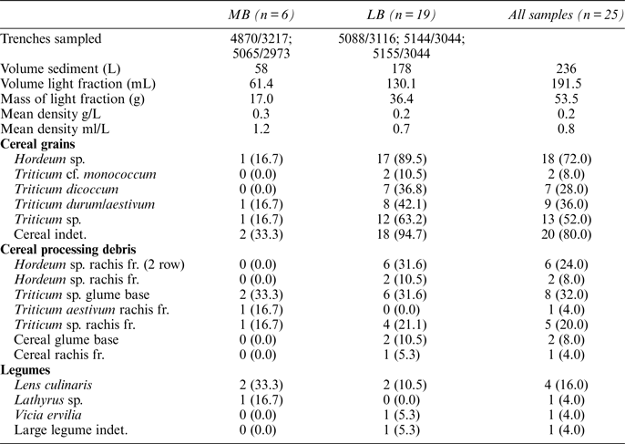
During the 2014 field season, twenty-seven archaeobotanical samples were collected from a variety of archaeological contexts, including pits, tannurs, above surfaces, burials, room fill, and ashy occupational debris.Footnote 57 Attempts were made to restrict all samples to ten litres, but in some instances smaller samples were collected owing to the size of the context being excavated. All sediment samples were floated in the field by Tiffany Earley-Spadoni using the bucket method. Light fractions were carefully dried at the site and then transported to the University of Connecticut for analysis. Six of the samples date to the Middle Bronze Age, twenty date to the Late Bronze Age, and one was from a mixed MB/LB context. The mixed MB/LB sample and a single LB sample that contained only modern contaminants were excluded from the analysis, leaving six MB and nineteen LB samples.
For the first phase of analysis, the volume of each sample was measured in millilitres. Samples were then sieved using four, two and one millimetre sieves in order to facilitate the sorting process. Material less than one millimetre was scanned, and any identifiable plant parts were removed for identification. Material greater than one millimetre was sorted in full, and all seeds, fragments, and plant parts were identified to the most specific taxonomic rank possible using the reference collection in the Archaeobotany Laboratory at the University of Connecticut, which is rich in flora from Southwest Asia. A range of flora, seed identification manuals, and archaeobotanical reports were also used to assist with identifications and provide ecological and ethnobotanical information (e.g., Davis Reference Davis1965–1985; Bor Reference Bor1968; Townsend and Guest Reference Townsend and Guest1974; van Zeist and Bakker-Heeres Reference van Zeist and Bakker-Heeres1984 (1986), Reference van Zeist and Bakker-Heeres1985 (1986); Nesbitt Reference Nesbitt2006). This report provides presence/absence data gathered during the first sorting phase. The second phase of targeting very small numbers of unknown species (typically less than five per sample) and counting specimens is currently underway.
Archaeobotanical Remains
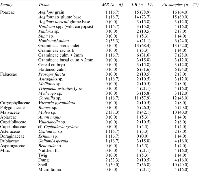
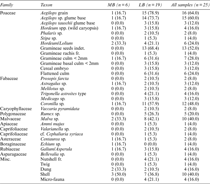
Of the nineteen samples presented here, 236 liters of sediment were collected, yielding 235 millilitres of light fraction ( table 1). The samples varied in size from one to thirty-six millilitres (0.01–7.23 g) with a mean density of 0.8 ml/L and 0.2 g/L. Such variation between sample sizes is common within archaeobotanical samples from Southwest Asia and reflects differences in plant deposition and preservation across the site. In general, while a few samples were sterile, plant remains were well-preserved, yielding a wide range of taxa. Overall, fifty-one taxonomic categories were recorded ( table 1 and 2), with a more diverse range of taxa being present in the LB assemblage relative to the MB samples. This difference most likely reflects the smaller number of MB samples rather than real differences in plant use.
Number and size of Middle and Late Bronze Age archaeobotanical samples with list of cultivars encountered. Numbers associated with taxa indicate the count of samples within which each taxon is present (and ubiquity expressed as a percentage)

Presence of wild species within MB and LB archaeobotanical samples. Numbers associated with taxa indicate the count of samples within which each taxon is present (and ubiquity expressed as a percentage)
The vast majority of samples contain wood, albeit in small proportions. Several fragments greater than four millimetres were recovered from the flotation samples, but the vast majority of wood fragments were observed in the one to two, and two to four millimetre fractions. Animal dung remains including intact sheep or goat pellets were recovered from both MB and LB samples, indicating the likely use of dung fuel at Kurd Qaburstan. The use of dung fuel across Southwest Asia has been widely reported for Bronze Age sites (e.g., Miller Reference Miller1984; Miller and Smart Reference Miller and Smart1984; Smith Reference Smith and Weiss2012), so this finding accords well with data from other sites such as Abu Salabikh in southern Iraq, where intact sheep or goat pellets were also recovered (Charles Reference Charles1998).
Cereal grains and cereal processing debris are ubiquitous across the site but tend to be recovered in small proportions (typically less than five per sample). The cereals recovered, in order of ubiquity, are: Hordeum sp. (barley), Triticum sp. (wheat), Triticum durum/aestivum (durum/bread wheat), T. dicoccum (emmer), and T. cf. monococcum (einkorn). It is not possible to reliably distinguish between two-row and six-row barley based on small assemblages of grain, but the presence of Hordeum vulgare subsp. distichum (domesticated two-row barley) rachis fragments within a third of the LB samples indicate that two-row barley was cultivated widely by the LB inhabitants of Kurd Qaburstan. Charles (Reference Charles1998) also reports the importance of barley at Bronze Age Abu Salabikh. Of the wheat remains, Triticum durum/aestivum are most commonly encountered, followed by T. dicoccum and very infrequent finds of T. cf. monococcum. It is impossible to distinguish between durum and bread wheat through observations of grain alone, but it is possible to separate the two species based on observations of well-preserved rachis fragments (Zohary et al. Reference Zohary, Hopf and Weiss2012:32). Isolated finds of Triticum aestivum rachis fragments indicate that bread wheat, at a very minimum, was cultivated at Kurd Qaburstan. Triticum dicoccum glume bases are frequently encountered, so is possible that emmer was an important crop despite the paucity of grains. A similar pattern of deposition was observed within Ubaid period archaeobotanical samples from Tell Zeidan in northern Syria and Kenan Tepe in south-eastern Anatolia where emmer glume bases were found in abundance (Graham and Smith Reference Graham and Smith2013; Smith et al. Reference Smith, Graham and Stein2015).
Interestingly, Aegilops grains and glume bases (including Aegilops tauschii glume bases) are well represented across the site, occurring in two-thirds of the LB samples. Members of the Aegilops genus, colloquially known as goat grass (kharken, keina, or jaganma in Kurdish), are described in the Flora of Iraq as “a formidable object to some grazing animals because of the awns” yet they are “devoured with avidity by goats” (Bor Reference Bor1968:174). Because of the widespread presence of animal dung at Kurd Qaburstan, it is possible that the Aegilops finds at Kurd Qaburstan represent the remains of grasses consumed by goat either in pastures or as intentionally-fed fodder. Aegilops remains were regularly encountered in third millennium b.c. contexts in north-eastern Syrian sites such as Tell Brak and Tell Leilan (Charles and Bogaard Reference Charles, Bogaard, Oates, Oates and McDonald2001; Smith Reference Smith and Weiss2012). At Tell Leilan, large caches of cleaned Aegilops grains were recovered within an Akkadian period palace (Smith Reference Smith and Weiss2012), so the intentional production and processing of Aegilops for fodder or even for human consumption across the region needs to be seriously considered. Once the awns have been removed, they no longer present a formidable challenge to consumption. Very little has been written about the nutritional value of Aegilops grain, but it is likely to possess similar qualities to wheat since it is closely related to Triticum.
Conversely, crop legumes are poorly represented at Kurd Qaburstan. Isolated finds of Lens culinaris (lentil), Lathyrus (grass pea), and Vicia ervilia (bitter vetch) indicate that these varieties were used. The paucity of legumes relative to cereals is common across Southwest Asia and generally reflects the reduced preservation potential of legumes.
A variety of wild legumes were recovered from the samples, including Astragalus, Melilotus, Trigonella astroites, Medicago, and large amounts of Coronilla seeds. These are all small seeded legumes that are frequently encountered in archaeobotanical samples across Southwest Asia that date to the third and second millennia b.c. (e.g., McCorriston Reference McCorriston1995; Charles and Bogaard Reference Charles, Bogaard, Oates, Oates and McDonald2001; Smith Reference Smith and Weiss2012). These varieties often are found in pasture lands and as weeds within cereal crops. Also recovered were smaller amounts of Prosopis farcta, a plant frequently enjoyed by sheep and goat. Its presence at Kurd Qaburstan alongside remnants of dung fuel is, therefore, not too surprising, and the presence of charred Prosopis farcta seeds may indicate remnants of grazing. Elsewhere in Iraq and northeast Syria, Prosopis farcta is common at such sites as Abu Salabikh, Nimrud, and Tell Leilan (Helbaek Reference Helbaek and Mallowan1966; Charles Reference Charles1998; Smith Reference Smith and Weiss2012). Use of Prosopis farcta seeds is not restricted to grazing, however. Colloquially known as “poor woman's date” in Syria (and kharnūb or estiri in Kurdish), the plant is often referred to as a famine food, but ethnobotanical work conducted in Syria by Alexia Smith in 2007 indicated that the seeds are still regularly consumed by villagers, particularly women and children who grind the seeds into a paste and mix it with sugar prior to consumption. Although the plant has been denounced in the US as a noxious weed, Townsend and Guest (Reference Townsend and Guest1974: 41) describe Prosopis farcta in the Flora of Iraq as a “most important plant”. In antiquity, dense thickets of the plant are thought to have created habitats for wild animals. Owing to its deep rooting system, its presence in cultivated fields may have been beneficial to cereal production since, in addition to enhancing soil nitrogen, soil moisture would have been conserved during fallow periods.
The plant remains from Kurd Qaburstan provide support for the widespread use of dung fuel and pasturing or foddering activities. Owing to the paucity of samples dating to the MB, it is difficult to reliably discuss differences in plant use between the two periods. Spatial differences in plant use during the LB may exist, with a greater diversity and density of plants being present in units 5144/3044 and 5155/3044 on the eastern side of the main mound. These potential differences will be investigated more fully once the secondary processing of the archaeobotanical remains has been completed and full specimen count data is available.
Conclusions
Excavation, geophysical survey, and the results of artefactual and ecofactual analysis are beginning to provide details on the character, organization, and history of Kurd Qaburstan in the second millennium b.c. and thereafter. Our data reveal that the site reached its greatest extent in the Middle Bronze Age and was surrounded by an enclosure wall at that time. The geophysical results indicate that Middle Bronze period Kurd Qaburstan was not a “hollow city” but contained a dense population in this period. Although the ancient identity of Kurd Qaburstan is unknown, the location and occupational history of the site are consistent with the cuneiform evidence regarding Qabra (MacGinnis Reference MacGinnis2013b), as is the peak of occupation in the Middle Bronze Age. In the succeeding Late Bronze/Mittani period, occupation mainly was restricted to the high mound, where possible elite buildings had elaborate drainage installations. Clearly, management of water and drainage was significant in both the Middle Bronze and Mittani periods of occupation at Kurd Qaburstan, similar to the drainage systems of Nuzi (Starr Reference Starr1937, Reference Starr1939).Footnote 58 Neither the Middle Bronze nor the Late Bronze/Mittani period has been documented in any substantial fashion in the Erbil region before, so the results are important in helping to fill a gap in the history of the Erbil area and in northern Mesopotamia in general. In addition, the discovery of a cemetery of Achaemenid date may reveal details on the history of that period in the Erbil region, and the occasional appearance of Ubaid and Halaf potsherds in second millennium b.c. contexts suggest that Chalcolithic period occupations exist deeper in the site. In future seasons, we hope to continue investigation of these different periods of occupation to further reveal the history and character of a large city of the second millennium b.c. on the Erbil plain.