INTRODUCTION
Dalswinton was a key site in the Roman occupation of south-west Scotland throughout the Flavian period, chosen to control an important north/south line of communication through the western lowlands along the natural corridor created by the river Nith (fig. 1). The fort at Dalswinton, Bankhead sits on the edge of a steep scarp overlooking that river, just at the point where the valley begins to narrow significantly to the north as the river emerges from the Southern Uplands. That strategic location is underlined by the presence of a number of adjacent, overlapping temporary camps at Bankfoot, though only one is of sufficient size to house a substantial force, possibly a battle-group involved in the subjugation of south-west Scotland.Footnote 1 The size and history of the fort further confirms its importance. Originally some 3.5 ha in area measured over the ramparts, it was subsequently expanded to 4.2 ha. Thus, it was one of the largest forts in Flavian Scotland, smaller in size only than the legionary base at Inchtuthil in Perthshire and the fort at Newstead, situated on the main route into Scotland on the eastern side of the country. When Roman forces began to be withdrawn from Scotland in the late Flavian period, Dalswinton, like Newstead, continued to be garrisoned until the withdrawal to the line of the Tyne-Solway isthmus under Trajan c. a.d. 103/5.Footnote 2 However, by the time of the reconquest of Scotland under Antoninus Pius, its role had been superseded by a new fort at Carzield, some 4.7 km to the south-east.Footnote 3
Location map of Flavian forts in Scotland. (Copyright: Dr D.J. Breeze with addition. Contains OS data © Crown copyright and database right 2018)

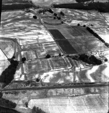
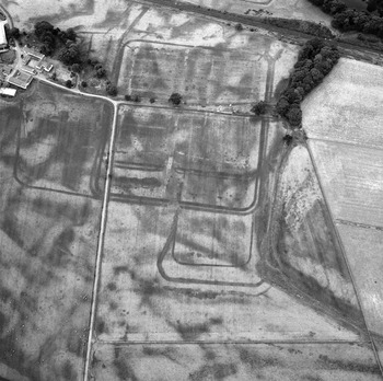
Our current knowledge of Roman Dalswinton is based very largely on the evidence of aerial photography, augmented by limited excavation. J.K.S. St Joseph surveyed the site from the air at regular intervals from its discovery in 1949 to the mid-1970s.Footnote 4 His work was amplified subsequently by reconnaissance undertaken by RCAHMS (now Historic Environment Scotland) and others.Footnote 5 As a result, the exploration of Dalswinton has become a classic example of the effectiveness of aerial reconnaissance for Roman archaeology in Britain. Exceptional ground conditions during the drought year of 1949 allowed the fort at Bankhead, with its multiple annexes, to be revealed for the first time (fig. 2).Footnote 6 These circumstances have been replicated only occasionally thereafter (e.g. fig. 3). Limited excavation was undertaken in 1954. This involved a single, long, narrow trench through the interior in the south-east quadrant and across the defences into the east annexe, reflecting the standard methodology of the day for investigating Roman forts. The excavation confirmed that the two phases of occupation apparent on the aerial photographs both related to the Flavian period; suggested that the smaller fort preceded the larger; identified some timber buildings in the interior and a lead furnace in the east annexe; and enabled the excavators to speculate about the likely garrisons, suggesting a cohors milliaria equitata followed by an ala milliaria.Footnote 7 The latter was quickly challenged by Eric Birley, who suggested that the fort may have held a task force rather than a single unit, a view followed by Frere who proposed two cavalry regiments in residence.Footnote 8
Aerial view of Dalswinton looking north-east, taken in 1949. (Cambridge University Collection of Aerial Photography, copyright reserved, DV009)

Aerial view of Dalswinton looking south-west, taken in 1977. (SC 1658767 © Crown Copyright: HES)

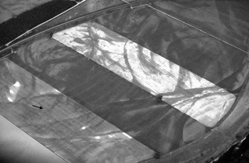
Subsequent advances in understanding have, until now, been based entirely on further aerial reconnaissance. By the mid-1970s the broad pattern of the site complex had been established (fig. 4) and a series of interpretations of the wider historical significance of the various elements postulated, which have seen little change thereafter.Footnote 9 The major new development after the discovery of, and limited excavation within, the two-phase Flavian fort was the identification of two sides of a double-ditched enclosure situated on the alluvial plain immediately adjacent to the river Nith at Bankfoot (figs 4 and 5).Footnote 10 This was apparently also of two phases as there are two parallel sets of double ditches some 70 m apart on its south-eastern side, though whether this represents a reduction or expansion in area cannot be established from the aerial data alone. This enclosure, covering at least 8 ha in area at its greatest extent, was considered to be a possible earlier fort.
Aerial photographic transcription of Roman and other sites at Dalswinton, Butterhole Brae and Ellisland (after Jones Reference Jones2011, illus. 112, with amendments and additions). (© Copyright and database right 2018 Ordnance Survey licence number 100057073)

Aerial photograph of the 25 ha Stracathro-type camp and the postulated fort at Bankfoot, showing its northern corner (arrowed), taken in 1984. Note the broad, irregular, curving indications of river movement that both precede and post-date the Roman installations. (Copyright: W.S. Hanson)

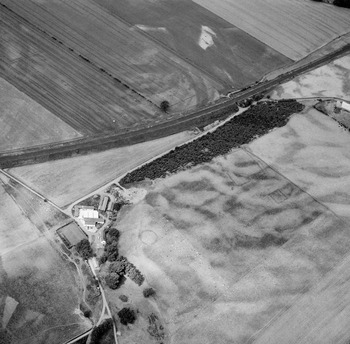
This second postulated fort was situated within a large temporary camp with distinctive so-called ‘Stracathro-type’ gateways. This camp (I) encloses some 25 ha and its eastern side overlaps another, but much smaller (at least 2.4 ha), Stracathro-type camp (II). This is the only certain example of two camps with this distinctive gate style overlapping.Footnote 11 A further small (0.66/0.32 ha), two-phase temporary camp is known just across the river at Ellisland. Additionally, at Butterhole Brae, some 500 m along the scarp to the east of the fort at Bankhead, there is a group of three small enclosures (fig. 6). These are of uncertain date, though the larger of the two square enclosures (c. 0.24 ha) has been identified as a possible Roman fortlet and the nearby small penannular enclosure suggested as a Roman ‘signal-tower’.Footnote 12
Aerial photograph of the three enclosures at Butterhole Brae from the east, taken in 1977: penannular enclosure mid-left; sub-rectangular enclosures mid-right. Part of the north-eastern side of the 25 ha Stracathro-type camp is also visible beyond the railway line. (SC 1579140 © Crown Copyright: HES)

In recent years Dalswinton has once again become a focus of attention with a re-plotting of the remains of the temporary camps recorded from the airFootnote 13 and a series of geophysical surveys being undertaken. Thus, the time is right for a reappraisal of this important military complex. In this paper, we report on the results of geophysical surveys undertaken across the large Stracathro-type camp and the postulated large forts at Bankfoot, and over the forts and annexes at nearby Bankhead. These surveys have been integrated with a reassessment of all the available aerial photographic evidence from different sources and with the 1 m resolution LiDAR (airborne laser) survey undertaken by the Environment Agency. The aims of this reassessment are fourfold: to enhance our understanding of the character of the various installations at Bankfoot, particularly the postulated large, two-period fort; to establish the internal organisation of the fort at Bankhead in both its phases in order better to determine the likely garrisons; to shed light on the activities that may have been taking place in the multiple annexes of that fort; and to shed further light on the character of the adjacent enclosures at Butterhole Brae.
THE GEOPHYSICAL SURVEYS
The contribution of geophysical survey to Roman military archaeology in Britain has been considerable in recent years, particularly in elucidating the character of ancillary structures such as annexes and vici and, indeed, the wider landscape around military sites. Important published examples of such work include the surveys at Birdoswald on Hadrian's Wall, Maryport in Cumbria, various sites in Wales, including Llanfor, and Drumlanrig only some 16 km to the north of Dalswinton.Footnote 14 In Europe, geophysical surveys are transforming our knowledge of the remains in and around Roman forts, for example through the extensive surveys at Carnuntum on the Danube in Austria.Footnote 15 The results of these surveys are increasingly facilitating fuller integration with the aerial photographic record.
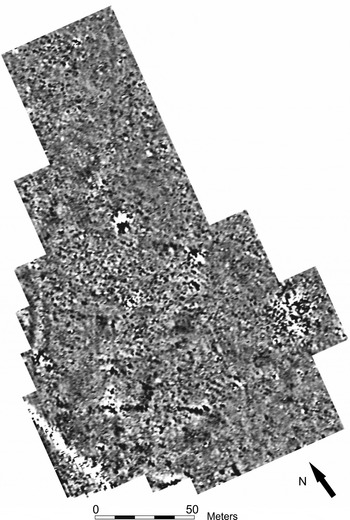
At Bankfoot, Dr Kay Winkleman carried out a magnetic survey in June 2009, under the direction of the first and last named authors and Dr Claus-Michael Hüssen of the Römisch-Germanische Kommission, using the SENSYS MAGNETO-MX-16 Channel system consisting of sixteen fluxgate gradiometers with a base distance of 650 mm and a measuring range of ±3,000 nT. The sensors, positioned 110 mm apart, were attached to a cart towed by a 4×4 vehicle containing a Global Positioning System (GPS)-defined location system. Data processing was undertaken with SENSYS’ own Magneto software. Critically, this system allowed the survey of some 15 ha in two days and, because of the close spacing of the sensors, was suited to the potential detection of features as small as post-holes 0.2–0.4 m in diameter (fig. 7). A good deal of extraneous noise is apparent in the survey, particularly regular, long-wave noise in the range of maximum ± 2.0 nT. This appears as the curvilinear lines approximately at right angles to the plough lines, particularly in the most westerly field. This was found to be caused by the up and down movement (+−30 mm) of the sensors while in motion and could not be filtered out. Supplementary noise also occurred because of the presence of iron-rich sandstone in the stony ground.
Grey-scale graphic of the magnetic survey by SENSYS at Bankfoot superimposed over the aerial photographic plot of the camps and postulated two-phase fort. Black-white palette: +/− 3nT. (© Copyright and database right 2018 Ordnance Survey licence number 100057073)

As a methodological exercise, a 1.85 ha area of the fort and north annexe at Bankhead was also surveyed by SENSYS for purposes of comparison with the more traditional Bartington gradiometer survey described below. This produced very similar results and confirms the ability of the SENSYS sensor to detect structural remains.
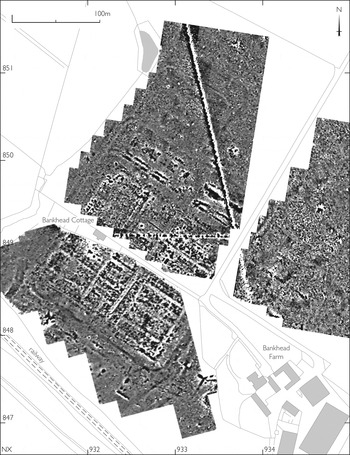
The magnetic surveys of the forts and annexes at Bankhead employed two Bartington Grad 601 fluxgate gradiometers; the sampling and traverse intervals in the 20 m by 20 m grids were 0.25 m and 1 m respectively in 2009 (fig. 8). Six grids in the south-eastern corner of the fort were resurveyed in 2011 with the same gradiometer, but at 0.5 m traverse interval. This yielded an expected improvement in results, although their quality does not call into question the validity of the main dataset. Resistivity survey with a twin probe array Geoscan RM15 instrument at 0.5 m sampling and traverse intervals was carried out on only a limited scale in the fort and north annexe (fig. 9) and in the east annexe.
The combined magnetic survey of the fort at Bankhead, including the north, south and east annexes, in the context of the modern landscape. (© Copyright and database right 2018 Ordnance Survey licence number 100057073)

Grey-scale graphic of resistivity survey of the north-west sector of the Bankhead fort and its north annexe (black-white palette 420-257 ohms) superimposed on the magnetic survey. (Copyright: R.E. Jones)

The magnetic and electrical data were processed and visualised using Geoplot 3.1; both datasets required Despike and interpolation processing steps, the former also requiring Destagger and the latter low pass filter. Measurements of magnetic susceptibility were taken on only a limited scale across the east annexe with a Bartington MS2D coil system at 1 m sampling and traverse intervals; in this case the results were visualised with Surfer (Golden Software) v. 6. The interpretation plan (fig. 11) provides a more selective view of the results of the magnetic survey for the fort and annexes at Bankhead. It highlights the ditches and roads, and picks out the frequent and usually small locations of mainly high positive magnetic anomalies that are deemed potentially significant. Numerical annotations on the plan are explained in the discursive text below.
Dalswinton lies in an area of sandstone and subordinate breccia; wacke and mudstone lie nearby. Survey conditions were good at Bankhead as the hay harvest at the time of the survey in 2009 had just been gathered in, while the south field and east annexe were in pasture. In recent years, the agricultural regime in the south field has been more benign than in the north field, with a greater emphasis on pasture and concomitantly less plough damage. Though the extent of the survey was constrained by farm buildings and associated access roads, the terrain is generally flat apart from the southern flank of the fort and parts of the east annexe. The soil, however, was hard and especially stony, which impacted on the resistivity survey and also explains the relatively noisy magnetic background of the area arising from the variable iron content in the sandstone pebbles. Survey conditions were ideal on the flat, low-lying alluvial plain of the river Nith at Bankfoot, where the hay fields had been harvested. This area, however, continues to be subject to regular ploughing.
DALSWINTON, BANKFOOT: DOUBLE-DITCHED ENCLOSURE AND STRACATHRO-TYPE CAMP
Since its discovery in 1972, there has been considerable speculation concerning the significance of the large, double-ditched, two-phase enclosure at Bankfoot (figs 4 and 5). Its possible identification as a fort was immediately recognised on the basis of its double-ditches, which are not readily paralleled in temporary camps. On the other hand, the presence of tituli at the gateways is more reminiscent of camp than fort defensive architecture, though they are very occasionally attested at forts, such as at Hod Hill in Dorset and Bar Hill on the Antonine Wall.Footnote 16 An earlier date than the fort at Bankhead was presumed because of its inferior location on the low-lying flood plain of the river.Footnote 17 Indeed, both the aerial photographs and the geophysical survey (figs 5 and 7) confirm the erosive effect of the movement of the river since Roman times. It has removed approximately half of the double-ditched enclosure and some 20 per cent of the Stracathro-type camp, though it is also clear that such movement was not confined to the post-Roman period. For example, at Beattock in the Annan valley, a study of the palaeo-channels demonstrated significant movement of the Evan Water during the Roman period.Footnote 18 Further aerial reconnaissance in 1984 identified the north angle of the Bankfoot enclosure allowing re-calculation of its area, between at least 8.01 ha and 6.37 ha for the two phases, and thus supported its possible interpretation as a so-called vexillation fortress.Footnote 19 Such installations, known primarily from aerial photography, have seen limited investigation and, accordingly, are relatively poorly understood, but seem to have served as bases during campaigning.Footnote 20
The recognition of up to four phases of Roman occupation at Dalswinton, two at Bankfoot and two at Bankhead, prompted further speculation that the former might relate to a pre-Agricolan military presence in the area.Footnote 21 Thus, one particular aim of the survey was to try to establish whether any buildings could be identified within the Bankfoot enclosure to confirm its identification as a vexillation fortress. In addition, given its juxtaposition with the large Stracathro-type camp, the opportunity was taken to investigate whether any traces of occupation could be identified within the latter also.
The magnetic survey encompassed some 15 ha within three large parallel fields across the whole of the area of the postulated early two-phase fort and a substantial part of the 25 ha Stracathro-type camp that surrounds it (fig. 7). The line of the double ditch on the north-east side of the Bankfoot enclosure is clear across all three fields, but does not reveal the north-west corner that was recorded from the air in 1984 as the line runs into an area of heavy riverine erosion at this point. Apart from a possible entrance break near the west side of the middle field, the line of the double ditch appears to be continuous. However, the outer line on the south-east side is not discernible, while the inner line is only very faintly visible. To the west and south the enclosure has been eroded by the river Nith, as was also clear from the aerial photographs. Significantly, there are no signs whatsoever of buildings within the enclosure. While confidence in this observation may be partially undermined by the failure to see more substantial features running parallel to both the plough lines and the direction of the survey vehicle, the strength of the signal obtained from the ditches running at right angles to them should mean that at least 50 per cent of any buildings would be apparent. This would suggest that the enclosure is not a vexillation fortress as previously thought, but a more temporary work.
There are many strong positive and weak negative anomalies apparent in the magnetic data distributed widely across the three fields. They tend to be fairly evenly scattered in the area not affected by post-Roman riverine erosion. Since they appear both within and outside the double-ditched enclosure, they are most likely to relate to the 25 ha Stracathro-type camp. This association is reinforced by a particular linear concentration that is apparent inside the ditch on the north-west side of the camp (fig. 7). These anomalies may be pits, but are more likely, on the basis of their magnetic signature and location, to be field ovens. Some small, positive cropmarks are also apparent on a number of photographs (e.g. fig. 5), which may represent similar features.Footnote 22 Both pits and ovens have been attested by excavation within the camps at Kintore, Inveresk and elsewhere, while the clustering of ovens at the back of the rampart is a common feature in forts.Footnote 23
Finally, the aerial photographs have consistently revealed a short stretch of a second ditch running parallel to the surviving sector of the south-west side of the Stracathro-type camp close to its south corner (fig. 5). This was not recorded in the geophysical survey as very little showed in this area and the survey did not extend further east into the next field. Nor does the feature appear on St Joseph's interpretative map of the remains. This is probably because the inner line has tended to be regarded as of later date, perhaps linked to drainage of the field, as after a distance it appears to cut across the outer line and head in a southerly direction towards the river (fig. 4).Footnote 24 However, it seems too much of a coincidence that a relatively recent drainage feature should closely mirror the line of a temporary camp ditch for some 90 m, so this may indicate yet another camp on the Bankfoot terrace. Moreover, the turning of the inner line to cut across the perimeter of the known camp is reminiscent of the oblique traverses found in the gateways of Stracathro-type camps. The presence of a further camp here seems a more likely interpretation than that the 25 ha Stracathro-type camp was double-ditched only along its south-western side.
DALSWINTON, BANKHEAD: FORT AND ANNEXES
A total area of 9.84 ha was magnetically surveyed across three large fields immediately adjacent to the farm. These covered most of the fort, the whole of the north annexe and substantial parts of the east and south annexes (fig. 8). As is commonly the case in Roman forts, the interior is magnetically noisy, as are some of the ditches making up the defences. This compares markedly with the results obtained from the annexes and wider environs. Prominent positive anomalies occur where there has been burning and/or anthropogenic activity; thus pits, trenches and ditches, which have infilled with burnt material or rubbish, will appear magnetically enhanced. On the other hand, some ditches, particularly those forming the defences of the fort, have over time infilled with natural sediments whose magnetic contrast with the parent soils is relatively small.
The magnetic survey in the north-west field shows the northern part of the fort and the north annexe (fig. 10). The two strong linear anomalies running diagonally across the field almost at right angles to each other and meeting at its eastern edge are modern pipelines and will not be discussed further. The lade from the Brandy Burn, which is visible on the aerial photographs taken in 1949 curving across the north-west corner of the fort ditches and turning to run parallel with one of the internal road lines, was already being obliterated by ploughing at the time of the excavations by Richmond and St Joseph (fig. 2).Footnote 25 It is less apparent in the magnetic survey and not easily distinguishable from archaeological remains, but appears as a narrow negative linear anomaly running parallel with the via quintana. Two clusters of very strong anomalies to the west of the main pipeline outside the area of the north annexe are likely to have been caused by modern metal disturbance. The same may apply to one located towards the western side of the south annexe (but see below).
Grey-scale graphic of the magnetic survey of the northern sector of the Bankhead fort and north annexe in greater detail (black-white palette +/− 10 nT). (Copyright: R.E. Jones)

THE NORTH ANNEXE
Most of the ditches surrounding the northern annexe in both its phases are clearly, if faintly, visible in the magnetic survey (fig. 10). However, the outer north ditch of Phase 2 is not readily discernible, though the aerial photographs (figs 2 and 3) suggest that it runs through an area of disturbed ground. Slightly beyond its presumed line a possible ditch is just visible, which seems partially to surround the extended north annexe. This corresponds with what appears to be a geological feature in the aerial photographs and that interpretation is preferred here. The proliferation of defences would suggest that the original north ditch of the Phase 1 annexe, extending to c. 1 ha in area, was infilled to maximise the internal area in Phase 2 (c. 0.9 ha). The new inner ditch of Phase 2 is usually transcribed as very broad, but it is quite clear from a number of the aerial photographs (e.g. fig. 2) that it is in fact made up of two closely-spaced ditches. This may explain why the magnetic signal appears disjointed midway along the north-facing line of the ditch (figs 10 and 11 no. 2). According to both the aerial photographs and the magnetic survey, the entrance to the north annexe was close to the north gate of the fort in both phases.
Geophysical interpretation plan of the north and south sectors of the fort at Bankhead and its annexes. The numbers relate to features referred to in the text. (© Copyright and database right 2018 Ordnance Survey licence number 100057073)

Apart from the area overlain by the northern extension of the fort, there is very little sign of activity within either of the two phases of the north annexe. There are, however, a small number of discrete strong positive and associated weak negative anomalies that are suggestive of pits or areas of burning. Occasional short linear anomalies do not align with the enclosure and their significance is unclear. The absence of evidence of occupation or other activity within the north annexe is also confirmed by the aerial record. However, some photographs (e.g. fig. 2) indicate strong positive cropmarks of a line of at least four large, slightly irregular maculae just inside the line of the north ditch of Phase 1 which presumably represent areas of disturbance on the inside edge of the rampart.
NORTHERN HALF OF FORT
The western defences of the fort in both its phases and the northern defences of Fort 2 are faint but apparent in the magnetic survey (fig. 10). The line of the western ditches is clearly continuous across the junction with the inner line of northern defences (figs 10 and 11 no. 3), confirming that the northern extension of the fort was a secondary addition. Indeed, the northern defences of Fort 1 show as very strong linear anomalies, reflecting the fact that they had been deliberately backfilled with occupation debris, either when the fort was extended or at the end of occupation of the site (see below). Even the ‘parrot's beak’ configuration of the ditch ends on the eastern side of the north gate is highlighted in this way (figs 10 and 11 no. 4). The ditches of both phases of the fort are very clear in the more limited area of the resistivity survey (fig. 9). Here the double ditches of the Phase 2 fort are readily apparent, though those of the Phase 1 fort are marginally less so. The ramparts within the ditches of both phases show only as areas of lower intensity activity in the magnetic survey and faintly in the LiDAR survey (fig. 13) on the west side, particularly in Phase 2. Very strong anomalies behind the ramparts, particularly in the northern extension of the fort, presumably represent the location of cooking ovens and associated pits (figs 10 and 11 no. 5). Similar concentrations of positive cropmarks are also visible on the aerial photographs (e.g. figs 2 and 3).
In the interior, the road lines show as mainly weak negative features in the magnetic survey and as negative cropmarks in the aerial photographs (figs 2, 3 and 10). One of the widest and most striking runs south from the north gate of Phase 1. This must be the via principalis of the first fort as it appears to have been continuous across the interior, its line being truncated only by the ditches of Phase 2. Since the larger portion of the fort lies to its west, it indicates that it faced east, as Richmond and St Joseph noted.Footnote 26 The northern gates of the two phases of the fort are slightly offset from each other, with the earlier phase located some 15 m to the east of its successor. However, the geophysics suggests that, rather than continuing in a straight line southwards through the fort, the road from the Phase 2 gate curves slightly to the east avoiding the eastern end of a long building (see below) to join the line of the Phase 1 via principalis (figs 10 and 11). This is confirmed by the absence of any sign in the aerial photographs of road metalling crossing the line of the Phase 1 ditches. This suggests that the orientation of the fort actually remained unchanged in Phase 2, which in turn would explain why some other features of the primary fort remain clearly visible. Thus, the line of the via quintana defining the rear of the central range is also consistently apparent right across the fort, particularly in the magnetic survey (figs 10 and 11).
Though slightly less apparent in the latter, the line of the intervallum road behind the north rampart of the Phase 1 fort is clearly visible on the aerial photographs as a negative linear cropmark that curves to the south as it meets the via principalis (figs 2 and 3).Footnote 27 This orientation mirrors the inward curve of the so-called ‘parrot's beak’ ditches and suggests that they were accompanied here by an in-turned gateway, as seen for example in the Flavian forts at Elginhaugh and Oakwood.Footnote 28 The geophysics indicates the presence of small but strong anomalies on the north side of that road, again suggestive of cooking ovens and associated pits behind the rampart (figs 10 and 11 no. 6). A particular concentration of positive cropmarks in the north-west corner of the fort is probably a reflection of some of the same features, though they extend across the road into the interior where a different explanation is likely (see below).
The stretches of linear, occasionally strongly positive magnetic features running parallel to and between the ramparts of Forts 1 and 2 must relate to the later phase (figs 10 and 11 no. 7). On the west side they seem to reflect the remnants of a narrow rectangular building some 76 m by 11 m, with possible subdivisions, presumably an accommodation block running from the west rampart to the road leading from the north gate. If this represents a single building, its dimensions are commensurate with a legionary rather than an auxiliary barrack.Footnote 29 On the east side of that road an intense, much wider, linear magnetic anomaly is apparent, mirroring the aerial photographs that show a similarly wide positive linear cropmark, which should reflect an area of deeper soil (figs 2 and 3). This indicates the underlying presence of a similar building that had been burnt or extensively disturbed during the demolition process. On the basis of the available distance between the via principalis and the intervallum road apparent in the southern sector of the fort (below), this would suggest a barrack some 64 m long, which is again much closer to legionary than auxiliary dimensions. Immediately to the south of these buildings the magnetic survey seems to reflect only the underlying Phase 1 fort ditches. Thus, the space created by infilling them does not seem to have been used for buildings in the second fort, but may have continued to be an area of demarcation, separating the two postulated legionary barracks from the rest of the fort. Indeed, the ditches may even have been left open, only becoming infilled with demolition material when the fort was finally given up. A similar arrangement is attested at Newstead, where the slightly larger Antonine fort is subdivided by a wall and where a legionary presence is indicated for both the Flavian and Antonine occupations.Footnote 30
South of the Phase 1 ditches, the broad outline of the tripartite division of the fort can be discerned from the disposition of the roads. They indicate that the central range was some 32 m wide; the praetentura and retentura c. 64 m and 52 m wide respectively. However, within these demarcated blocks the characterisation of buildings, and even their orientation, is much less clear. There appears to be a long, narrow building, c. 11 m wide and 52 m long, running west/east across the northern part of the retentura defined by a sequence of strong positive anomalies in the magnetic survey (figs 10 and 11 no. 8). Given its suggested dimensions, this was presumably an auxiliary barrack, as these tend not to exceed 52 m in length,Footnote 31 though whether infantry or cavalry is impossible to determine. Since it is visible by virtue of its subsequent demolition, it presumably relates to Phase 2. Elsewhere in the retentura, however, the general impression is of structures that run north/south. This may reflect changes between the two phases of occupation or, perhaps more likely, simply the predominant direction of modern ploughing. There are several areas of intense magnetic disturbance, which tend to concentrate towards the periphery of the block as if the demolition process had concentrated debris in specific areas. This is broadly paralleled at Elginhaugh where demolition clearly involved the dismantling of the timber buildings, accompanied by the collection and burning of associated material.Footnote 32
There are three roads subdividing the central range visible in the magnetic survey, though only the more southerly two are apparent in the aerial photographs (e.g. fig. 2).Footnote 33 A clear narrow positive anomaly running across the centre of an apparently very wide road, visible only in the magnetic survey, is probably a stone-lined drain, perhaps demarcating the edge of a narrower road to the south from an adjacent area of hard-standing (figs 10 and 11 no. 9). A similar feature is also evident alongside the most northerly of the subdividing roads in the southern sector of the fort (below). At Elginhaugh such drains were confined to the line of the via principalis and the buildings in the central range.Footnote 34 The roads define four separate blocks, though whether all relate to the same phase is unclear. Within the most northerly are positive anomalies suggestive of two adjacent buildings some 22 m long aligned north/south in the manner of paired granaries (figs 10 and 11 no. 10). No structures are evident in the next block to the south, though its narrowness (c. 9 m) would indicate that any building must have been aligned east/west. A large, discrete bipolar anomaly, with two adjacent positive anomalies, may indicate pits or collections of demolition material at the western end of the block (figs 10 and 11 no. 11). Traces of buildings apparently orientated east/west can be discerned in the third block, which is c. 15 m wide (figs 10 and 11 no. 12), before the end of the magnetic survey area is reached. The most southerly subdividing road would have run around the north side of the principia (fig. 2). The latter, along with the via praetoria and via decumana, is largely lost under the modern access to Bankhead Cottage.
The praetentura is almost centrally subdivided by an east/west road clearly visible in both the aerial photographs and the magnetic survey (figs 2, 10 and 11). In Phase 1 this would have created two blocks c. 64 m wide and c. 27 m/35 m deep. There is a series of strongly positive magnetic features suggestive of a number of subdivided buildings within each of the two blocks. Though it is difficult to determine their orientation, the general impression is that the buildings ran east/west, as the configuration of the blocks would suggest was most likely. The width of the blocks indicates that the length of any barracks located therein would have been much closer to legionary than auxiliary dimensions.
In Phase 2 the praetentura was reduced to c. 52 m in width by the insertion of a slightly narrower road running parallel to the via principalis some 9 m to its east (fig. 11). Though this is only faintly indicated in the aerial photographs (figs 2 and 4),Footnote 35 and barely in the magnetic survey (figs 10 and 11), it mirrors the situation in the southern half of the fort where the equivalent road is much more clearly defined (see below). The narrowness of the block thus created to the east of the via principalis may indicate that the buildings therein were orientated north/south. Alternatively, the space may have been filled by a series of open-ended buildings or tabernae facing onto the via principalis, as attested at Llanfor.Footnote 36 The consequent reduction in the overall dimensions of the main blocks to the east would indicate that they probably contained barracks or stable-barracks for auxiliaries.
SOUTHERN HALF OF FORT
The quality of the output of the magnetic survey for the southern sector of fort (fig. 12) is considerably better than that in the northern sector, a situation that also applies to the corresponding aerial photographs. The primary reason may be that this field has been more often in pasture and so less frequently ploughed since the 1950s. Nonetheless, it is more difficult to disentangle the structural remains because of the overlapping phases of occupation and accompanying adjustments to the layout of the interior.
Grey-scale graphic of the southern sector of the fort in greater detail (black-white palette +/− 10 nT). (Copyright: R.E. Jones)

The defences of the fort are very clear in the aerial photographs (figs 2 and 3), indicating large double ditches on both the east and west sides, with a short stretch of a third ditch some 8 m beyond them on the south-east side. Only the inner ditch continues around the fort along the top of the break of slope on the south, with a gap indicating an entrance corresponding with that on the north side. This ditch seems unduly wide on the west side of this entrance, where the ditches of Phases 1 and 2 appear to have diverged slightly, while one close-up photograph from 1949Footnote 37 hints at an earlier ‘parrot's beak’ ditch extending across the west side of the Phase 2 entrance gap. The magnetic survey (fig. 12) confirms this general pattern, though the ditches are not readily visible on the west side as they approach the south-west corner, and it adds the probable presence of a slighter, outer ditch along the south side. Excavation in 1954 confirmed that the double ditches of the two phases on the east side were largely spatially coincident, though those of the first phase were generally smaller.Footnote 38 A conflation of the two phases may explain the apparent thickening of the inner ditch on the west, east and part of the south side apparent in both the aerial photographs and the magnetic survey (figs 3, 10 and 12).
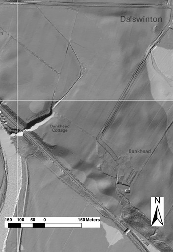
The ramparts show primarily as areas of low intensity activity in the magnetic survey (fig. 12), though they are also faintly visible in the LiDAR survey in the south-west corner (fig. 13). Given the close juxtaposition of the ditches of the two phases of occupation and the absence of any evidence, other than straightening at the gates, that the intervallum road had been moved, there seems no reason to argue that there was any substantive change in the location of the rampart.Footnote 39 Groups of discrete bipolar anomalies between the rampart and intervallum road in the south-eastern corner presumably represent the location of cooking ovens and associated rubbish pits (figs 12 and 11 no. 13). Concentrations of positive cropmarks are visible in the same location on the aerial photographs (figs 2 and 3) and one such shallow pit, containing suggested remains of iron-working, was excavated by Richmond and St Joseph.Footnote 40 Negative linear cropmarks crossing the line of the rampart and berm in both the south-east and south-west corners presumably represent drains debouching into the ditches.
LiDAR DSM image of Dalswinton at 1 m resolution. (Copyright: The Environment Agency 2015. All rights reserved. Graphic prepared by Giles Carey)

The underlying tripartite division of the fort evident in the northern sector is similarly apparent both in the aerial photographsFootnote 41 (figs 2 and 3) and the magnetic survey (figs 11 and 12), but with the addition of a further road in Phase 2 (below). Though rather less clear than at the north gate, the line of the intervallum road behind the east and west ramparts is visible on the aerial photographs as a negative linear cropmark that curves gently inwards as it heads towards the line of the via praetoria and via decumana respectively. Again this suggests the provision of in-turned gateways in Phase 1. A similar pattern is indicated at the south gate on some of the early aerial photographs (e.g. fig. 2)Footnote 42 and confirmed by the widening inwards of the intervallum apparent on either side of the via principalis in the magnetic survey.
The via principalis continues to be the most striking negative feature in the aerial photographs. The importance of its line is highlighted in the magnetic survey by the clear narrow positive anomaly that runs down its east side, indicating the provision alongside it of a stone-lined drain. As it approaches the repositioned south gate, the drain cuts across the line of the road curving towards the west (figs 12 and 11 no. 14), a feature visible also in the aerial photographs (fig. 2),Footnote 43 perhaps mirroring the slight indications that the road from the north gate curves east to reuse the via principalis of the Phase 1 fort. Aerial photographs taken in July 1975 by John Dewar also hint at a curve in the line of the road at this point.Footnote 44
In Phase 2 a new, slightly narrower road is added running parallel to the via principalis only some 9 m to its east, mirroring the situation in the northern half of the fort (above), though there the traces are much less clear. The provision of buildings within the narrow block so created is also, therefore, likely to replicate those in the northern half of the fort. Most of the roads crossing this narrow block should relate to Phase 1. This is supported both by the relative faintness of the traces on the aerial photographs and the fact that, with the exception of the road closest to the intervallum, their lines are overlain by a series of positive anomalies in the magnetic survey (figs 11 and 12).
Thus, the praetentura seems to have been subdivided into four blocks by three lateral roads in both phases of occupation. Narrow buildings, which appear to run east/west, are differentially apparent as discontinuous positive anomalies in all four blocks, but are particularly evident in the two northernmost. The configuration of the anomalies in the second block from the north is suggestive of two narrow buildings facing each other (figs 12 and 11 no. 15). The dimensions of the blocks in Phase 2, c. 52 m long by c. 9/20 m wide, would not be inappropriate for a single or a pair of auxiliary barracks/stable-barracks respectively. The excavation by Richmond and St Joseph cut diagonally across the narrow central and two most southerly blocks,Footnote 45 its northern end clearly visible in the magnetic survey (figs 12 and 11 no. 16), and their findings correlate generally with the layout for Phase 2 indicated in the survey. Their identification of a pit running parallel with an internal wall in the centre of one Phase 2 building, which goes unmentioned in the excavation report, is reminiscent of the positioning of urine pits in stables/barracks.Footnote 46 It is not possible with any certainty to determine the layout in Phase 1. However, if the buildings had been aligned east/west, the space available would have been large enough to accommodate barracks of legionary dimensions, as suggested for the northern half of the fort. Richmond and St Joseph identified construction trenches beneath the intervallum road of Phase 2 which appear to indicate structures aligned north/south, though they also took this to imply that the southern rampart of Phase 1 was positioned further to the south than its later counterpart.Footnote 47 This suggestion is difficult to reconcile with the location of both the southern defences and the Phase 1 intervallum road apparent in the aerial photography. It is probable, however, that these excavated construction trenches relate to buildings at the back of the rampart. Indeed, there are strong, positive linear anomalies in the magnetic survey suggestive of such structures in the south-east corner of the fort (figs 12 and 11 no. 17).
Both the aerial photographs and the magnetic survey (figs 2 and 12) indicate that the retentura is laterally divided into four blocks, almost exactly mirroring the praetentura in Phase 2. The discrete positive anomalies in the two central blocks seem to respect the lateral roads and their pattern is broadly suggestive of narrow buildings running east/west, presumably auxiliary barracks/stable-barracks as in the northern half of the fort where the width of the blocks is the same (c. 52 m). Three discrete very strong positive and associated weak negative anomalies in the more northerly of the two central blocks are suggestive of areas of intense burning (figs 12 and 11 no. 18). While this could indicate the presence of a workshop, they are more likely to represent the process of demolition at the end of the occupation where the wattle and daub panels of the buildings were collected together and burnt, as is attested at Elginhaugh.Footnote 48 This is also likely to be the explanation for the general character of the anomalies across the interior of the fort, which show distinct concentrations in a linear pattern where demolition material had found its way into construction trenches, presumably after the removal of the timber uprights.
Again both the aerial photographs and the magnetic survey indicate that the central range is divided into four blocks. The most northerly presumably represents the southern half of the principia. A very strong, positive linear magnetic anomaly alongside a dividing road marks its southern limit, which is either the southern wall of the building or a stone-lined drain (figs 12 and 11 no. 19). The next block to the south is largely taken up by a courtyard building, presumably the praetorium, possibly with a compound or more open space to the east (figs 12 and 11 no. 20). Arrangements in the next block to the south are not dissimilar, though the possible compound lies to the west of the building, which is smaller and does not appear to be provided with a courtyard (figs 12 and 11 no. 21). There are no clear buildings apparent in the most southerly block, though there are concentrations of positive anomalies, particularly to the north of the probable bend in the via principalis. There is also a suggestion both in the magnetic survey and in some of the early aerial photographsFootnote 49 of an area of hard-standing or a short stretch of road running across the centre of this block from the south gate.
SOUTH ANNEXE
A broad positive cropmark continues the alignment of the ditches on the west side of the fort just after the turn of the south-west corner and continues down the slope beyond the railway line (e.g. fig. 2).Footnote 50 It is also clearly visible in the LiDAR survey as a broad hollow (fig. 13). Though this probably had origins in a natural drainage gully, both its location and linearity suggest there may have been human augmentation in order to define the west side of the south annexe. A similar, though somewhat less regular, cropmark running not quite parallel to the first, diverges from the ditches of the fort just before they start to turn the corner, but does not appear to continue. Neither of these features is apparent in the magnetic survey, though a possible ditch continuing the line of the outer fort ditch can be discerned on the east side of a broad positive anomaly that curves towards the line of the Brandy Burn (figs 11 and 12). This may represent a second annexe ditch, but could simply mark the edge of this broad, probably natural feature.
The line of a broad ditch defining the east side of the annexe is consistently very clear in the aerial photographs and readily apparent in the magnetic survey (fig. 12), particularly in the section closest to the fort. It runs from the south-east corner of the fort, continuing the line of the outer fort ditch down the slope on either side of the modern railway towards the haughs. It was clearly a substantial feature as it still survives as a partial earthwork in the LiDAR survey (fig. 13). It even continues in a more denuded state for some 80 m across the corner of the intensively ploughed field adjacent to the river, where it has occasionally also been recorded as a cropmark (fig. 2).Footnote 51 Some 14 m to the east and parallel to it is a second ditch of similar dimensions. This narrows at its northern end as it abuts the southern ditch of the eastern annexe, at which point it is barely discernible in the magnetic survey. This too can be traced on aerial photographs down to the edge of the haughs (fig. 2).Footnote 52 In addition the aerial photographs indicate a narrow ditch cutting obliquely across the eastern half of the interior from the south ditch of the fort, though only a short section closest to the fort is apparent in the magnetic survey (figs 12 and 11 no. 22). This may indicate some partial subdivision of the annexe.
There are no obvious structures recorded in the south annexe, although little of it has been magnetically surveyed. There are, however, a number of discrete, sometimes quite large, strong positive anomalies and associated weak negative anomalies that are likely to represent large pits or areas of burning, perhaps small furnaces. Some are in linear groups, one of which may have been truncated by the inner east ditch of the annexe (figs 12 and 11 no. 23); some correspond with discrete positive cropmarks on the aerial photographs. The strongest and most extensive anomaly lies just outside the south-west quadrant of the fort (figs 12 and 11 no. 24). It may have been caused by modern metal disturbance, but it lies in what would have been the ideal position for a bath-house in terms of both water supply from the Brandy Burn and subsequent drainage down the steep scarp towards the river.
The south annexe appears to be integral to the layout of the fort as it is the only one of the three annexes that is not clearly divided from it by two substantial ditches. That said, a second much slighter ditch is hinted at both in the magnetic survey and, to a much lesser extent, on the aerial photographs (figs 2 and 12). It is located down the slope a little further to the south, which, on analogy with the sequence of excavated ditches just north of the south-east corner,Footnote 53 is likely to relate to the first phase of occupation.
EAST ANNEXE
The east annexe is considerably larger (2.6 ha) than that to the north, covering the whole of the east side of the Phase 2 fort, though much of the southern half is now lost under modern farm buildings and associated features. According to the aerial photographs (figs 2 and 3), it is defined by a substantial single ditch extending from the outer north ditch of the fort to the inner ditch which defines the east side of the south annexe.
The character and extent of the annexe relating to the first phase fort, however, is less clear. Visible on the early aerial photographs (e.g. fig. 2),Footnote 54 running parallel to, but only some 25 m beyond, the defences on the east side of the fort, is a further narrow ditch which curves to the west as it crosses the line of the south ditch of the Phase 2 annexe. Richmond and St Joseph recorded that it had been filled with debris from a nearby lead-working furnace relating to that later annexe.Footnote 55 The curve and western continuation of the ditch, however, is very faint. Indeed, it does not feature at all on later photographs (e.g. fig. 3), nor on the magnetic survey. If it continues, its alignment would link with the outer south ditch of the fort. Since no corresponding return of this ditch has ever been noted to the north, it presumably re-joined the Phase 1 fort defences on the south side of the east gate under the modern farm access road. It would thus have defined a rather small annexe of no more than 0.25 ha.
The line of the ditch on the northern and eastern sides of the Phase 2 annexe is just visible in the magnetic survey as a weak linear anomaly (fig. 14). On either side of the north section two similar parallel anomalies are also evident which have no correspondence in the aerial photographs and are of uncertain significance. The clearest feature in the survey is a quite strong positive linear anomaly located towards its southern limit. This corresponds with a variable negative/positive cropmark that continues across the annexe on the same alignment as the intervallum road of the Phase 1 fort before turning south. It has generally been considered to be a ditch, an interpretation that would be supported by the magnetic survey, but in several of the aerial photographs it looks in parts more like a trackway (e.g. fig. 3). In some there is a clear indication that it crosses the ditches on the eastern side of the fort.Footnote 56 Resistivity survey across its western end proved unhelpful, though two 10 m-wide hotspots, which are indicative of burning or firing activity, were noted in the magnetic susceptibility survey in the same area (fig. 15). Given it lacks a clear link either to the ditches of the fort or to the organisation of the Phase 1 annexe further south, it seems unlikely to have defined the northern limit of that annexe.
Grey-scale scale graphic of the magnetic survey in the east annexe and the area outside it to the north-east in greater detail. (Copyright: R.E. Jones)

Contour map of the magnetic susceptibility results (white-black palette 0–100 ms units) across the centre of the east annexe superimposed on the magnetic survey. (Copyright: R.E. Jones)

Various other features have been identified in the interior of the Phase 2 annexe. A short stretch of road is recorded in the aerial photographs heading towards the postulated east gate of the fort before disappearing under the modern farm access road (fig. 3). To the north of it, apart from a small oval-ditched enclosure presumably of prehistoric date, only a few scattered pits are visible in the aerial photographs. This part of the field was not available for geophysical survey as it is now overlain by a secondary access road to the farm buildings and, unfortunately, no archaeological examination took place ahead of its construction. A small number of positive anomalies towards the southern limit of the magnetic survey may also represent pits, though their form and distribution is little different from the background signal for most of the rest of the field.
Significantly, in the southern part of the annexe Richmond and St Joseph found the remains of a lead-working furnace, quantities of burnt clay from which filled an earlier ditch.Footnote 57 This creates a strong bipolar anomaly in the magnetic survey indicating both its original position just inside that ditch, broadly coinciding with a large pit in the aerial photographs, and the subsequent deposition of material in the ditch (figs 2, 3 and 12). A similar bipolar anomaly a few metres to the west partially overlapping the line of the outer fort ditch may be a second furnace (figs 12 and 11 no. 25).
BUTTERHOLE BRAE
Some 500 m along the scarp to the south-east of the fort at Bankhead, St Joseph reported the discovery from the air of a series of three small ditched enclosures (figs 4 and 6).Footnote 58 The largest, some 49 m square with slightly rounded corners, is double-ditched on its north-west side. There is some dispute about the location of an entrance gap in the ditch, presumably the result of the variable character of the parchmark in rough pasture recorded at different times. An entrance on the north-east side is preferred here, as visible in fig. 6 and on a second aerial photograph taken two years earlier.Footnote 59 The size and shape of the enclosure, and its proximity to the fort and camps at Bankfoot and Bankhead, led St Joseph to suggest it was possibly a Roman fortlet, though this identification has never been corroborated. Less than 40 m to its north-east he recorded a second, much smaller, almost square enclosure measuring c. 14 m by 12 m internally, with more sharply defined corners. Some later photographs clearly indicate an entrance on the north-east side (fig. 6).Footnote 60 Originally St Joseph hinted at a Roman military function for this also, though he seems subsequently to have had second thoughts, as it does not feature in his later and more lengthy discussion of the Roman complex at Dalswinton.Footnote 61
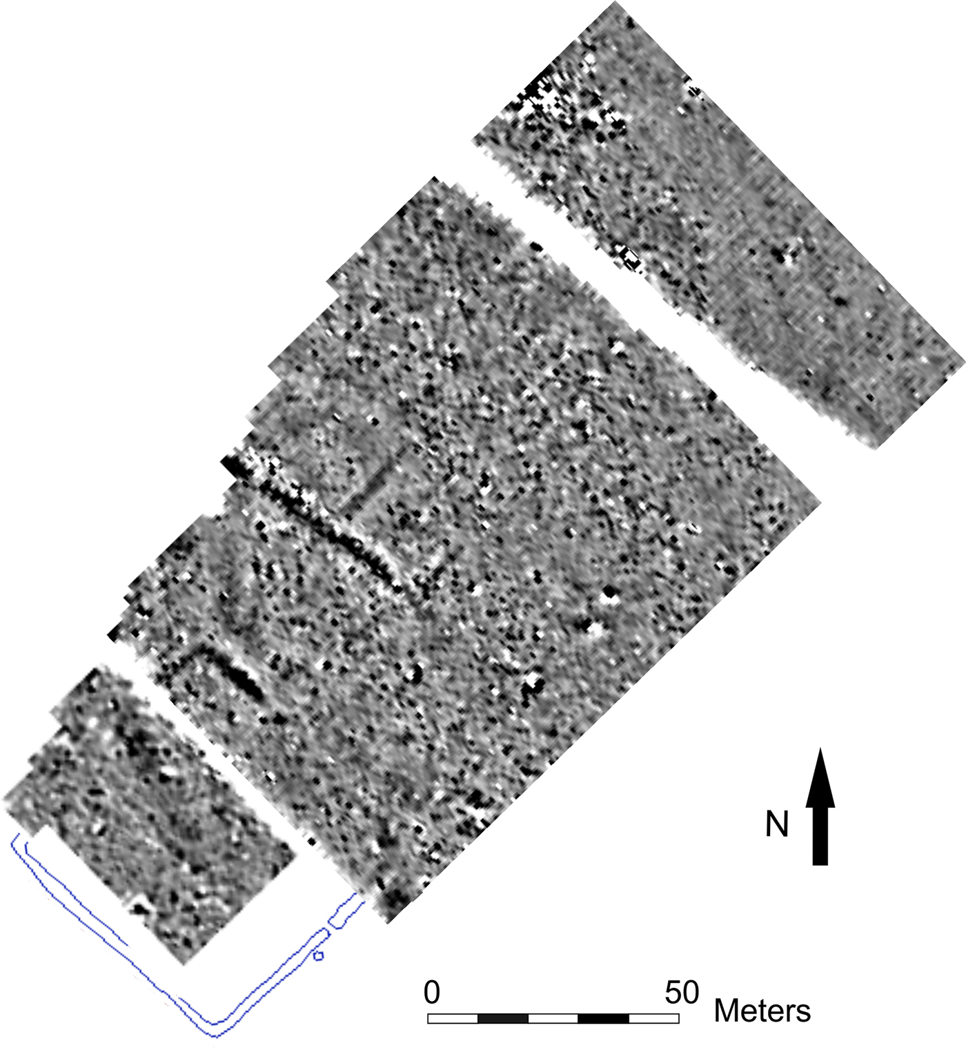
The field in which the two rectilinear enclosures now lie, and part of an adjacent field in which a possible prehistoric ring ditch had also been recorded on aerial photographs,Footnote 62 were surveyed magnetically in 2009 and 2011 (fig. 16). In 2009 the survey area (1.6 ha) lay in permanent pasture, the terrain sloping down from the scarp overlooking the river towards Dalswinton Loch to the north-east. The later survey covered the south-western half of the largest enclosure on the edge of the scarp and confronted very difficult conditions. It first required the trampling down of thick vegetation that impacted adversely on the quality of the results.
Grey-scale graphic of the magnetic surveys at Butterhole Brae (black-white palette +/− 10nT), superimposed over the aerial photographic plot of the larger enclosure. (Copyright: R.E. Jones)

Only the north-east sector of the larger enclosure was detected, the north corner registering more strongly than the east. No internal buildings were identified, the only possible features being a number of small, discrete strong positive anomalies, some associated with weak negative ones, some of which may be pits. The north corner was more sharply angled than previous interpretations of the aerial photographs have suggested.Footnote 63 This, combined with the absence of evidence of internal structures, casts considerable doubt on its interpretation as a Roman fortlet. A weak anomaly in the magnetic survey suggested the presence of a linear feature extending from the north-east corner of the enclosure in a broad curve towards the north, cutting across the north-east corner of the small square enclosure. No sign of this is evident on any of the aerial photographs. If it represents a ditch line, it suggests that the two enclosures were not in contemporary use and its character would further support the probable identification of the larger as a later prehistoric settlement enclosure.
The small square enclosure was clearly detected in the magnetic survey almost in its entirety, although not always strongly. It is, however, insufficiently clear on the north-east side to provide corroboration of the existence of an entrance, though there is a short linear anomaly running from the suggested position of that entrance to the middle of the enclosure. A broad, strong anomaly which overlaps most of its south-west side is probably the line of a recent pipe or drain. This was subsequently recorded continuing across the next field to the north-west for a distance of some 150 m, yet it does not appear on any of the aerial photographs and so is likely to be a more recent feature. In his discussion of possible aerial photographic evidence for early Christian cemeteries in south-west Scotland, Cowley included the enclosure, along with similar ones at Aird Cottage and Fox Plantation near Stranraer, in his list of possible square burial enclosures, noting the presence of indefinite small marks in the interior.Footnote 64 Indeed, several of the aerial photographs of the site do reveal an irregular, dark mark towards the centre (e.g. fig. 6), reflected in the magnetic survey by a cluster of strong positive anomalies. This may lend credence to his suggestion.
Finally, the nearby small penannular enclosure, located on the edge of the scarp overlooking the river, was not surveyed magnetically. While its identification as a potential Roman ‘signal-tower’ is not without analogies,Footnote 65 other morphological correlations are equally possible.Footnote 66 Nor is it clear why a signal- or watch-tower would be required at this location less than 1 km from a fort, on land which sits at a slightly lower altitude. Furthermore, the argument that relies on its juxtaposition with other Roman military remains is weakened when it is appreciated that it lies even closer to other aerial photographic evidence of prehistoric activity at Dalswinton Mains, less than 400 m to the east, or closer still in the next field to the north-west.Footnote 67 Finally, it lacks indication in any of the aerial photographs of the large post-holes needed to support an internal wooden tower and seems more likely to be a small hengiform structure. Harding and Lee are somewhat inconsistent in their assessment of that probability, though certainly cast doubt on its Roman identification.Footnote 68
CONCLUSIONS AND WIDER CONTEXT
One of the key findings of the survey was the reinterpretation of the Roman remains at Bankfoot. Given the lack of internal buildings, the double-ditched two-phase structure, previously identified as a possible vexillation fortress, should now be reclassified as being more temporary in character, although the double ditches indicate a greater level of protection than that usually afforded to temporary camps. Perhaps interpretation as a short-term base should be preferred: a site that required increased defences but was not occupied long enough to warrant the construction of buildings.
The recovery of information from the interior of the large Stracathro-type camp adds to the growing evidence for internal arrangements within temporary camps. The scatter of pits or ovens throughout its interior is paralleled in the seemingly random scattering of ovens excavated within the interiors of camps at Kintore in Aberdeenshire and Monktonhall in East Lothian, and in the pits and possible ovens recorded through cropmarkings at Glenlochar.Footnote 69 The uniformity of lines of pits seen at places such as Inchtuthil, some of which have been excavated, Dalginross and Moss Side near Hadrian's Wall is not apparent here, except behind the ditch on the north-west side. This is reminiscent of the common location of ovens at the back of the rampart in forts.Footnote 70
The Roman attribution of the three enclosures at Butterhole Brae must now be called into question. The lack of evidence for internal structures and the rather less regular morphology of the larger square enclosure as revealed by the magnetic survey makes it difficult to sustain interpretation of it as a Roman fortlet. Were this enclosure to be located elsewhere in Scotland, such as on the East Lothian plain, there would be little hesitation in identifying it as a later prehistoric settlement, an interpretation that is preferred here. Cowley has already suggested that the smaller square enclosure is an early Christian cemetery.Footnote 71 Both the magnetic survey and additional examination of the aerial photographic record would tend to support this identification. Similarly, the small penannular enclosure nearby is more likely to be prehistoric than Roman in date on the basis of the aerial record alone.Footnote 72
At Bankhead considerable difficulties of interpretation were created by a combination of circumstances: the impact of long-standing and intensive agricultural activity; the sometimes noisy magnetic background; and the overlapping of two phases of occupation. Nonetheless, the combination of geophysical and LiDAR survey with a re-analysis of all the aerial photographs available has facilitated a much improved understanding of the nature and development of the forts and their annexes.
The first phase of the fort was the more difficult to disentangle, but seems to have followed the same general layout as its successor. It can now be seen to have been provided with in-turned or recessed entrances and at least two annexes, a small one attached to the south-east quadrant of the fort and a larger one attached to the north-west quadrant. The southern annexe may also relate to Phase 1, but might have been added in Phase 2.
The size of the internal blocks defined by the configuration of the roads suggests that the fort probably contained a mixed garrison of legionaries and auxiliaries. Assuming all the buildings were oriented east/west, there could have been space for as many as eleven barracks of legionary dimensions (allowing c. 64 m by 11 m) in the praetentura. It is uncertain what or how many other types of structures might have been included, but there was more than ample room for a cohort and any associated storage buildings. Applying the same principles, there could have been space for as many as twelve auxiliary barracks/stable barracks in the narrower retentura. That would have provided ample accommodation for a cohors milliaria peditata or a cohors quingenaria equitata. If the southern annexe was part of the original layout, it lends some support to the suggestion of a cavalry presence (below). If, as is suggested, legionaries did make up a substantial part of the garrison, it is interesting to note that Maxwell has argued for an association between the activities of the legio II Adiutrix and the use of in-turned ‘parrot's beak’ ditches in Flavian fort entrances.Footnote 73 However, the more recent discovery of such gateways in the Flavian fort of Caergwanaf in southern Wales militates against this view, given that there is no evidence for that legion operating in this area.Footnote 74 Thus, while some support is provided here for the association of ‘parrot's beak’ entrances with legionary detachments, their specific attribution to legio II Adiutrix cannot be substantiated.
Though the fort was expanded in Phase 2, as Richmond and St Joseph suggested,Footnote 75 it does not appear to have been turned through ninety degrees. Rather, the via principalis continued in use with minor adjustments at each end to accommodate the slightly changed position of the gates. The northern extension appears to have housed two legionary barracks and may have continued to be demarcated from the remainder of the fort. The width of the praetentura was reduced by the addition of a new, narrower road parallel to the via principalis, the space between perhaps filled with tabernae or workshops. Auxiliary barracks/stable barracks running east/west will have filled most of the remaining space to the east. The arrangement of barracks/stable barracks in the retentura was probably similar to Phase 1, at least in the southern half of the fort. Thus, there would have been room for up to eleven barracks/stable barracks in the praetentura and twelve in the retentura. Overall the main body of the Phase 2 fort could have readily accommodated an ala quingenaria or a cohors quingenaria and a cohors quingenaria equitata brigaded together.
In the central range it was possible to establish the general outline of two probable granaries and two courtyard buildings, the more northerly of which was presumably the praetorium. The other could have been a second praetorium, a fabrica or even a hospital, as suggested at Llanfor.Footnote 76 These buildings are more likely to relate to Phase 2, but could be associated with both phases of occupation.
At 3.86 ha in area, the early Flavian fort at Llanfor in north Wales was similar in size to Dalswinton in its primary phase and seems to provide the best parallel for its overall layout. Llanfor was provided with twelve stable barracks in the retentura and a further four in the southern praetentura. Six slightly larger barracks c. 59 m in length in the northern praetentura were identified as providing accommodation for legionaries.Footnote 77 The partial reduction in the width of the praetentura in Phase 2 at Dalswinton may also be paralleled at Llanfor, where tabernae c. 7 m long opened onto the via principalis with a narrow road behind them.Footnote 78
In Phase 2 the provision of annexes was enhanced, as seems also to have occurred at Newstead at the same time.Footnote 79 Though the annexe to the north of the fort is broadly similar in both size and position to its predecessor, that to the east was expanded to cover the whole of the east side of the extended fort. The location and configuration of the southern annexe is highly reminiscent of the provision at the near-contemporary forts at Malling, Stirlingshire, and Cargill, Perthshire, where annexes continue down to the edge of the Lake of Menteith and the river Isla respectively.Footnote 80 A similar link to the river Nith, which is closest to the Bankhead fort at this point, suggests that the two most likely explanations for the primary function of this annexe were an association with the security and control of transhipped supplies and/or the provision of protected grazing and ready access to the river edge for watering horses. The latter would lend support to long-standing suggestions of a substantial cavalry presence.Footnote 81
There was no certain evidence of buildings in any of the annexes. The most likely position for the fort bath-house would have been on the edge of the scarp adjacent to the Brandy Burn in the north-west corner of the south annexe, and its location may be indicated by an amorphous, strong anomaly in the magnetic survey. Elsewhere in the south annexe and the southern half of the east annexe, the main features apparent in the magnetic survey were a series of strong, discrete anomalies or linear alignments indicating the presence of large pits or ovens/furnaces. The aerial photographs suggest a scattered distribution of pits or ovens, some of them quite large, in all three annexes. On this evidence it is difficult to argue that any of the annexes provided enclosed accommodation for civilians, as is suggested was the case at Newstead.Footnote 82 Rather they seem to have served a range of ancillary military functions, such as the housing of animals or minor industrial activities, including metalworking, as seems also to have been the case in the probable annexe to the south of the contemporary fort at Carlisle.Footnote 83
Very strong magnetic anomalies occur frequently within the fort, particularly defining walls, or drains at the edges of blocks of buildings, or as more amorphous spreads within those blocks. This is strongly suggestive of deliberate demolition at the end of the occupation of the site. Material would have been collected together and burnt, as was attested at Elginhaugh,Footnote 84 some of it then finding its way into disturbed construction trenches and open drains or pits. Demolition is, perhaps, further supported by the large number of pits scattered across the interior, which is apparent from the aerial photographs.
In both its phases, Dalswinton fits into a category of large Flavian forts with composite garrisons of cavalry and infantry. It is becoming increasingly clear that the infantry element of such garrisons consisted of legionaries. Apart from Llanfor and Dalswinton itself, as noted above, a legionary presence in conjunction with cavalry is also attested at Carlisle and, with slightly less confidence, at Newstead.Footnote 85 Such a mixture of troops would have been readily able to respond to any problem, combining the speed and range of cavalry with the solid dependability of heavy infantry. Davies has drawn particular attention to these sites, suggesting that they served as bases either in the primary stages of the occupation of newly-acquired territory or during active campaign operations; similarly, Hodgson and Hopewell see the Flavian examples in Wales and Scotland as campaign bases, serving the same function as vexillation fortresses.Footnote 86
While the latter interpretation may not unreasonably be applied to the short-lived establishment at Llanfor, a rather different role seems more appropriate for Dalswinton in both its phases. Once an enemy had been defeated, assuming their territory was then subsumed into the Empire, the active role of most auxiliary forts would have been to maintain local control and ensure security; to protect against raiding and ensure safe passage along the roads. Thus, after Agricola's successful campaigns in Lowland Scotland we see the establishment of a network of forts and occasional fortlets mainly linked by roads.Footnote 87 Within that system Dalswinton and Newstead both stand out in terms of their size and the character of their garrisons.Footnote 88 Newstead was located both at a nodal point within natural communication routes through the eastern Lowlands and adjacent to what had been a central place in the pre-Roman Iron Age settlement pattern.Footnote 89 As a result the garrison could have provided oversight and control of any substantial population movement through the east central Lowlands of Scotland. A similar function may be suggested for Dalswinton in relation to the western Lowlands. It could have controlled the route to the north-west, following the valley of the Nith towards the prime agricultural land on the Ayrshire coast, as well as providing oversight of the rich coastal plain of Dumfriesshire and Kirkcudbrightshire. Finally, both NewsteadFootnote 90 and Dalswinton were enlarged during the first stage of the withdrawal from Scotland in the later Flavian period when their location would have been coincident with the northern limit of Roman occupation. At this time their roles are likely to have involved watch and ward across a wide geographical area.
ACKNOWLEDGEMENTS
W.S.H. and R.H.J. are grateful to Dr Kay Winkleman of Sensorik & Systemtechnologie GmbH, Bad Saarow, Germany, who carried out the magnetic survey at Bankfoot (and part of Bankhead), and to Dr Claus-Michael Hüssen of the Römisch-Germanische Kommission who made this possible. Also to Dr James Bruhn who assisted with the survey.
R.E.J. is indebted to the late Sir David Landale and to Peter Landale for their permission to survey on the Dalswinton Estate and their enthusiastic support throughout the geophysical surveys. He is grateful to Dr Oliver O'Grady and John Malcolm who played a major part in the planning and execution of the early stages of the geophysical surveys. Cathy McIver, Dr Carmen Cuenca-Garcia, Gert Petersen, Dr Adrian Maldonado, Peta Glew, Dr Jeremy Huggett and many students of the Archaeology Department, Glasgow University are warmly thanked for their contributions. He also thanks Giles Carey for facilitating access to the LiDAR data and preparing fig. 13.
All three authors are grateful to Georgina Brown of Historic Environment Scotland for assistance with figs 1, 4, 7, 8 and 11 and to the anonymous reviewers for their constructive comments on this paper.