

Introduction: on the edge of the archaeological uncanny valley
Archaeological Cold War studies are significantly different from research projects regarding earlier periods. The formulated narratives may often be augmented by reports of still-living eyewitnesses. From available documents, photographs and films, knowledge about the second half of the twentieth century creates an illusion of being nearly complete (Schofield et al. Reference Schofield, Cocroft and Dobronovskaya2021, 39–40). The smaller temporal distance diminishes the impression of foreignness which is so frequently experienced when studying long-gone, ancient human societies. With the growth of temporal/cultural distance, the past becomes gradually less familiar to us. Incoherencies and uncertainties start to appear alongside things with which we are well acquainted. The metaphorical crossing of the ‘archaeological uncanny valley’ is not, however, just a matter of the passing of time. Beyond well-known socio-cultural reality lie layers of discreet and unspoken phenomena. Employment of archaeological perspectives may help explore some of them. Despite what is commonly believed, the recent past is neither plain nor obvious (Fairclough Reference Fairclough, Schofield and Cocroft2007, 20). And yet countless human thoughts drift towards it every day in a never-ending cycle.
There has recently been a growing number of archaeological publications regarding the Cold War era. This nearly half-century-long period globally affected every field of human existence. Its echoes can be traced in contemporary mentality, mass culture, art and social memory. As George Orwell (Reference Orwell1945) put it, ‘the state of prolonging indefinitely a peace that is no peace’ transformed both mentality and materiality. The relics of secretive military structures or peculiar forms of material culture from the former states of the Eastern Bloc have attracted the attention of both scholars and the general public (Burström et al. Reference Burström, Acosta and Noriega2013; Fairclough Reference Fairclough, Schofield and Cocroft2007; Fowler Reference Fowler2008; Reference Fowler, Cowley, Standring and Abicht2010; Hanson Reference Hanson2010; Kiarszys Reference Kiarszys, Stichelbaut and Cowley2016; Reference Kiarszys2019; McWilliams Reference McWilliams2013; Schofield & Cocroft Reference Schofield and Cocroft2007; Whorton Reference Whorton, Beck, Johnson and Schofield2002). They are appealing and intriguing precisely because of their secrecy, oddity and detachment from the present (Hanson Reference Hanson2016a). However, even basic interpretation of those objects requires expertise that reaches far beyond established knowledge to, e.g., military technology, architecture, psychology, cultural and political sciences. Thus, Cold War archaeology is undeniably a multidisciplinary endeavour. Decaying artefacts and abandoned places also possess the power of bringing back memories, evoking emotions and reflection (Lowenthal Reference Lowenthal, Shaw and Chase1989), and above all, they are nostalgic testimonies of passing time (Burström Reference Burström, Holtorf and Piccini2009, 140–41).
Some disused Cold War military sites are approached today as cultural heritage and protected. Particular examples recently became popular tourist attractions or were turned into museums due to high educational values, meaning to society, or significant influence on local identity (e.g. Fairclough Reference Fairclough, Schofield and Cocroft2007; Hanson Reference Hanson2016b; Kiarszys Reference Kiarszys2019; Schofield & Cocroft Reference Schofield and Cocroft2007; Schofield et al. Reference Schofield, Beck, Drollinger and Loxny2006; Reference Schofield, Cocroft and Dobronovskaya2021). Others were repurposed or simply demolished. Such circumstances illustrate how the public perception of things and places from the recent past may shift, over a relatively short period, from ‘useless rubbish’ to ‘precious material relics’ worthy of interest and taking care. However, the example discussed in this paper shows a different perspective. It raises questions about the role and meaning of historically prominent sites which are closed and still being used according to their original purposes.
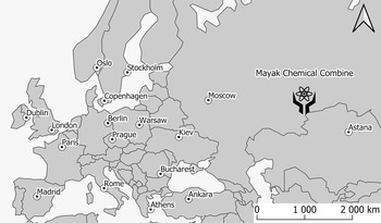
This article presents a case study of the Mayak Chemical Combine (Fig. 1), the production plant for weapons-grade plutonium and other radioactive isotopes for the Soviet nuclear programme. During the Cold War era, it was one of the most secret places in the USSR. Even today, it remains operational and inaccessible to outsiders. Thus, archival remote sensing data is the only possible and legal way of ‘traveling to this island of the clandestine archipelago’ (Solzhenitsyn Reference Solzhenitsyn1974) in a metaphorical, geographical and temporal sense. Its past is indeed like a ‘foreign country’ (Lowenthal Reference Lowenthal1985), sometimes inhospitable and with very limited access. Nevertheless, the discussed example proves that even such off-limits sites can be subject to archaeological investigation. Furthermore, it demonstrates well the cognitive potential of the archaeological perspective, due to access to diverse categories of sources from the era and specific ways of approaching research topics on the recent past within the discipline. Last, but not least, such studies not only serve to satisfy someone's curiosity, but may be used in future public debates regarding the consequences of production and testing of nuclear weapons.
Location of the Mayak Chemical Combine.

The analysis presented in this paper will focus on declassified records from the 1960s to the beginning of the 1970s, mainly spy satellite imagery from the CORONA and GAMBIT programs and Central Intelligence Agency [CIA] reports. I will attempt to combine those sources with contemporary historical knowledge and radiological publications to present a broader perspective, unavailable to the CIA photo interpreters at the time. The integration of such data has allowed more light to be shed on the Mayak and its environs than would be available from either category of those sources studied separately. Over the years, this plutonium plant caused severe devastation to the natural environment and harmed people living in its shadow. Discussed satellite photographs can be viewed as persuasive testimonies of the communist regime's reckless attitude to nuclear power and disregard for human life. Such an approach was not, however, exclusive to the Eastern Bloc. Numerous similar cases may be found throughout some Western European countries (mostly in their former colonial territories) and in the USA (Brown Reference Brown2013; Hanson Reference Hanson2010; Reference Hanson2016a,Reference Hansonb; Kuletz Reference Kuletz1998).
Rumours of enormous explosion and vast nothingness
In 1976, Zhores A. Medvedev, a Soviet biochemist living in exile in London, published in New Scientist a short paper entitled ‘Two decades of dissidence’ (Medvedev Reference Medvedev1976). The article soon became an object of wide-reaching international debate. The author discussed three cases of devastating consequences caused by political and ideological pressure exerted by the Communist Party on Soviet science. Naturally, USSR officials decisively denied all Medvedev's claims.
The first case portrayed the figure of Trofim D. Lysenko, a long-standing president of the Lenin Academy of Agricultural Sciences, whose pseudoscientific doctrines led to catastrophic acceleration of the death rate from starvation, especially during the agricultural crisis of 1932–33 (Medvedev Reference Medvedev1976, 264–65). The next event presented in the paper was the so-called Nedelin catastrophe of the prototype of the R-16 missile at the Baikonur Cosmodrome on 24 October 1960 (Chertok Reference Chertok2006, 598–99, 617–18; Medvedev Reference Medvedev1976, 266). The third case was related to the mysterious disaster near the non-existent Ural town of Blagoveschensk, where nuclear waste was allegedly buried in a ‘deserted area’. This is how Z.A. Medvedev described this accident:
Suddenly there was an enormous explosion, like a violent volcano. The nuclear reactions had led to overheating in the underground burial grounds. The explosion poured radioactive dust and materials high up into the sky […]. Strong winds blew the radioactive clouds hundreds of miles away […]. Many villages and towns were only ordered to evacuate when the symptoms of radiation sickness were already quite apparent. Tens of thousands of people were affected, hundreds dying, though the real figures have never been made public. […] Many towns and villages, where the radioactive level was moderate or high, but not lethal, were not evacuated. (Medvedev Reference Medvedev1976, 265–6)
In fact, the so-called Kyshtym Disaster of 1957, as it is known today, was the outcome of the non-nuclear explosion of the reactor-produced high-level liquid wastes stored underground (CIA 1981, iii; Cochran et al. Reference Cochran, Norris and Sukko1993, 520; Trabalka et al. Reference Trabalka, Eyman and Auerbach1979, 32). It did not happen in a ‘deserted area’, but in a relatively densely populated region. Due to scarce information, Z.A. Medvedev knew only the site's approximate location and did not know the exact date of the accident. However, most of the given detail appears to be fairly accurate.
A large nuclear facility is an easy target to the enemy ‘spy in the sky’. Dozens of square kilometres of allegedly uninhabited wasteland and abandoned villages should also be observed on the spy satellite imagery from the Cold War era, even when taken years after the mentioned disaster. Archaeological analysis of archival records may add a new dimension to further investigation of the military plant near Kyshtym and its impact on the surrounding landscape.
A nuclear generator of steam clouds
On 26 January 1965, a CIA spy satellite from the KH-7 GAMBIT programme took a series of photographs during mission 4015 over the southern Ural Mountains. The device was equipped with what was at the time a state-of-the-art high-resolution camera, able to obtain imagery of average ground resolution of 0.6–1.2 m (Fowler Reference Fowler, Hanson and Oltean2013, 50). The system was designed specifically for surveillance of high-priority targets such as nuclear facilities, military airfields and ICBM launch sites.
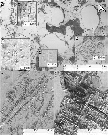
The series of pictures registered during the southern Urals overflight delivered a great detail of information (Fig. 2). The documented landscape consisted mainly of features very characteristic for this part of the Soviet Union: small towns, villages and collective farms (Fig. 2a, b, e–g), interspersed with vast areas of uninhabited land, forests, lakes and wetlands. The infrastructure was almost non-existent, and the road network appeared to be very sparse. Only in the vicinity of a few larger industrial cities like Chelyabinsk, Sverdlovsk, Ozyorsk, Kamensk-Uralsky and Kyshtym was the situation slightly different. From time to time, the observer's eye may also catch peculiar objects—emplacements of anti-aircraft systems. Some of those sites are clearly disused (Fig. 2d), while in other cases, vehicle tracks crossing fresh snow reveal active stations (Fig. 2c). What was so precious in those remote wastelands that it had to be protected from the prying eyes of camera lenses carried by enemy spy planes?
Characteristic elements of the cultural landscape of the southern Urals within the area of study during the winter period (GAMBIT KH7, mission 4015, 26.01.1965). (a) Frozen lakes, forests, and flatlands; (b) Kolkhoz (collective farm); (c) Active battery of anti-aircraft system S-75 Dvina; (d) Inactive position of anti-aircraft artillery (calibre 85 mm or 100 mm); (e) Modern village of Metlino with regular spatial pattern; (f) Techa village with characteristic historical spatial pattern; (g) Centre of Kasli Town. (United States Geological Survey.)

At the time when the satellite mission 4015 was carried out, the landscape was completely covered with a thick layer of snow. For several months, sub-zero temperatures had dominated, dropping below −20°C during the night. No wonder that all the lakes visible on the collected imagery were frozen. All but one.
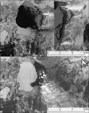
Lake Kyzyltash, located about 10 km east from Kyshtym, not only had not yet frozen, but its surface was vaporizing (Fig. 3a). A white cloud of steam was lifting along its eastern edge. The only possible explanation of this phenomenon was the conclusion that the Soviets had installed in the lake the heat exchangers from the nuclear reactors of the nearby Mayak Chemical Combine (Cochran et al. Reference Cochran, Norris and Sukko1993). The steam indicated the ongoing production of weapons-grade plutonium. Almost two years later, another GAMBIT spy satellite recorded an enormous steam cloud from Lake Kyzyltash, hovering over tens of square kilometres, a clear result of the further growth of the manufacture (Fig. 3b).
Lake Kyzyltash. (a) Despite the winter period and months of sub-zero temperatures, the waters of the lake are not frozen, and a white cloud of steam is lifting along its eastern edge (GAMBIT KH7, mission 4015, 26.01.1965); (b) The partially frozen Lake Kyzyltash with a thick cloud of steam indicating ongoing intensive production of weapons-grade radioactive isotopes (GAMBIT KH7, mission 4035, 10.12.1966). (United States Geological Survey.)

The serendipity effect and archaeology
The first aerial intelligence photographs of the Mayak plant were taken by the CIA Lockheed U-2 aircraft as early as 1959. However, the area of interest was, at the time, obscured due to cloud cover (CIA 1981, 4). Sortie 4154 flown by Francis Garry Powers, who was shot down near Sverdlovsk on 1 May 1960, also passed over the secretive nuclear facility (Pedlow & Welzenbach Reference Pedlow and Welzenbach1992, 176). In 1961, spy satellites of the CORONA programme had started regular surveillance (CIA 1981, 1, 4; Greer Reference Greer and Ruffner1995, 3–4). Since then, the Mayak Plutonium Combine has become one of the most carefully observed and documented places by space surveillance on Earth.
It is obvious that the photographs from the Cold War era reconnaissance satellites had been collected primarily with intelligence purposes in mind. Every such mission had precisely defined objectives. The overflights’ trajectories were calculated in detail to cover enemy areas of interest, with critical military targets and heavy industry. Photographs were taken automatically, strip after strip. However, due to the very nature of the satellite imagery, during the process they also, by chance, registered other features not related to the key intelligence objectives. These unexpected and unplanned data, in certain circumstances, may become a valuable source of information. They depend, however, on the questions asked by the photo interpreter. This concept is known as the serendipity effect and was defined by Arthur C. Lundahl, founder and first director of the CIA National Photographic Interpretation Center (Brugioni Reference Brugioni1989, 118; Cowley et al. Reference Cowley, Standring, Abicht, Cowley, Standring and Abicht2010, 1; Reference Cowley, Ferguson, Williams, Hanson and Oltean2013, 14, 21; Fowler Reference Fowler2004; Hanson & Oltean Reference Hanson, Oltean, Hanson and Oltean2013, 7). Since 1995, the Cold War reconnaissance satellite images are being gradually declassified and transferred to the National Archives and Records Administration (Fowler Reference Fowler, Hanson and Oltean2013, 47–48).
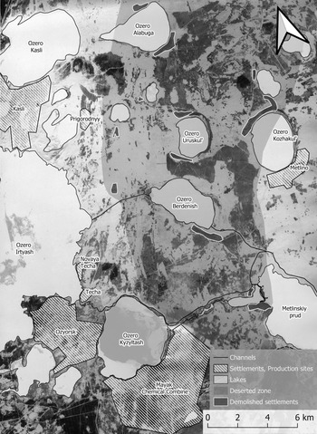
Photographs collected by CIA reconnaissance satellites, according to the serendipity effect, have a significant research potential for archaeological studies, even though their original creators and designers did not intend that. The primary purpose of the imagery analysed in this paper was to document the Mayak Chemical Combine. However, they also show many other peculiar anthropogenic features (Fig. 4). Some of them are related to the plutonium refinery operation, such as the newly built city of Ozyorsk, large reactor halls, railway links, power lines and a baffling system of elaborate water channels and dams. There is also evidence of nuclear disasters, dying forests, abandoned settlements and the relics of forced labour camps functioning within the Gulag system.
The area of study at the GAMBIT KH7 imagery (mission 4015, 26.01.1965), with indicated places of interest: lakes, settlements, the Mayak plutonium combine, artificial water channels, abandoned villages. The approximate extent of the deserted radioactive zone, which remains uninhabited up to the present day, was drawn based on satellite imagery from the 1960s. (United States Geological Survey.)

The archipelago of misery
In his famous work The Gulag Archipelago: An experiment in literary investigation, Aleksandr Solzhenitsyn (Reference Solzhenitsyn1974; Reference Solzhenitsyn1975; Reference Solzhenitsyn1978) portrayed the Soviet system of forced-labour camps. The author used a geographical metaphor to describe the Gulag's organization, which in his opinion resembled a chain of islands consisting of numerous isolated work camps scattered across the vast territory of the USSR. Such islands were a grim scenery of everyday misery, suffering and atrocities pushed to the most inhumane limits. Nearly all large-scale Soviet industrial projects relied, at the time, on the slave labour force, and the Mayak was no different, at least at the beginning of its existence.
Construction of the Mayak Chemical Combine started at the dawn of the Cold War in January 1946 (Brown Reference Brown2013, 88–9). The works were carried out in very primitive conditions and under tremendous political pressure due to the increasing momentum of the post-war arms race. The predominant part of the labour force consisted of Gulag convicts, compromised Red Army soldiers released from the German POW Camps and German POWs. In the beginning, no roads or railway lines led directly to the future plutonium refinery. Since its early days, a continuous insufficiency of building materials and machinery and organizational chaos plagued the endeavour. On a daily basis, workers were dying of accidents, overwork, malnutrition and diseases. In the spring of 1947, about 13,000 Gulag convicts, 8200 prisoners of war and 7000 civilian settlers were involved in constructing the plutonium facility. In the summer of the same year, another 16,000 prisoners arrived. Those numbers quickly grew during the following years (Brown Reference Brown2013, 90–91, 96). Some publications give much higher estimates of approximately 70,000 prisoners kept in 12 labour camps in 1947/48 (Cochran et al. Reference Cochran, Norris and Sukko1993, 508).
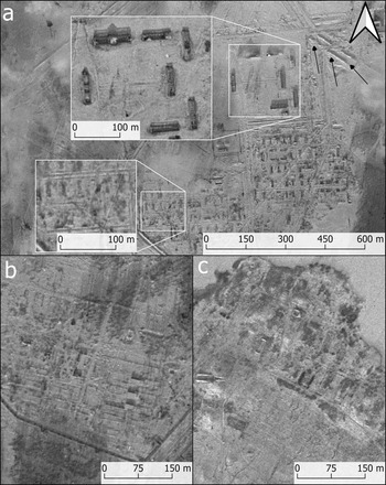
After Khrushchev's amnesty in 1953, many of the labour camps from the Gulag system were discontinued (Соколов Reference Соколов, Бородкин, Грегори and Хлевнюк2008, 65). Although the satellite imagery presented in this paper was collected over a decade after the Gulag's official closure, some of their remains can still be identified (Fig. 5a–b). In the middle of the 1960s, there were the remains of at least five abandoned labour camps visible within the area of study. It should be assumed that many others were already overbuilt or bulldozed. The spatial organization of the labour camps is very characteristic and repetitive. It brings to mind Second World War German Nazi work camps because of similar principles (Sturdy Colls Reference Sturdy Colls2015; Sturdy Colls et al. Reference Sturdy Colls, Kerti and Colls2020; Uziel Reference Uziel, Cowley, Standring and Abicht2010). Most of the prisoners’ barracks had already been demolished by the time the imagery studied here was collected. However, there are still cases of visible rectangular platforms where the buildings arranged in regular rows once stood. Every such grouping created a rectangular zone surrounded by a double fence (sometimes also by a ditch). There was a system of roads, gates and checkpoints with small guardhouses. Typically, the zone with guards’ quarters was distinctly separate from the rest of the camp. It was also often accompanied by other features, such as a parade ground and a shooting range (Fig. 5a). One of the sites with demolished buildings registered on the GAMBIT imagery was, however, different (Fig. 5c). It can be interpreted as relics of the Soviet Army labour battalion camp. This site's function was indicated by lack of internal security zones and military features built nearby: training ground, shooting range and fighting trenches.
Abandoned forced labour camps in the area of the Mayak Chemical Combine. (a) Relics of extensive forced labour camp, with distinguishable administration zone, parade ground, and guards’ barracks consisting of large brick buildings (disused and roofless at the time when imagery was collected). The shooting range is marked with arrows. The prisoners’ barracks (partly demolished) to the south are smaller ground-floor rectangular structures, ordered in groups and surrounded by a security fence (GAMBIT KH7, mission 4006, 14.03.1964); (b) Demolished labour camp with still visible regular spatial pattern, internal roads and platforms of dismantled prisoners’ barracks (GAMBIT KH7, mission 4015, 26.01.1965); (c) Demolished camp on the southern bank of Lake Kyzyltash. The particular spatial organization and nearby training ground with visible shooting trenches and other military features may indicate that it was the camp of the Soviet Army labour battalion mentioned in CIA reports (GAMBIT KH7, mission 4035, 10.12.1966). (United States Geological Survey.)

Secretive nuclear technopolis
Khrushchev's amnesty caused an outflow of Gulag convicts from the forced labour camps and endangered further development of the plutonium plant (Brown Reference Brown2013, 207–8). At that time, the communist decision-maker's approach to the organization of the enterprise began to change. The slave labour force had to be replaced by free workers. People were coming to this remote land, tempted by the promise of a living standard much better than in any other part of the Soviet Union, free apartments and shop shelves full of scarce goods (Brown Reference Brown2013, 213–20, 257–9). To put this into a better perspective, the higher standard of life meant, in fact, continuous access to the most basic amenities and food, things that were usually taken for granted in the Western world.
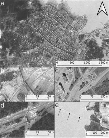
To accommodate new residents, a completely new town, known to the locals as Ozyorsk, was built on the peninsula between the Irtyash and Kyzyltash lakes (Fig. 6a). On 17 March 1954, it received closed industrial city status and a codename Chelyabinsk-40 (City-40), later changed to Chelyabinsk-65 (Soran & Stillman Reference Soran and Stillman1982, 3). When referring to Ozyorsk in their reports, the CIA specialists, unaware at the beginning of its codename, often named it after Novaya Techa (or Techa), a nearby village pre-dating the Mayak plant, or after Kasli, a nearby town (CIA 1964b, 1). The secret city was never marked on any of the maps produced within the USSR.
Ozyorsk. (a) The city centre with modernistic architecture, housing estates, alleys and parks (GAMBIT KH7, mission 4035, 10.12.1966); (b) Checkpoint at the northern entrance to Ozyorsk (GAMBIT KH7, mission 4035, 10.12.1966); (c) Contemporary view at the same checkpoint with a clearly distinguishable guardhouse, fencing, gates and traffic jam (© Maxar Technologies, © Google Earth, 05.2020); (d) Checkpoint at the southern entrance to Ozyorsk (GAMBIT KH7, mission 4035, 10.12.1966); (e) Patrol road on the frozen Irtyash Lake (GAMBIT KH7, mission 4035, 10.12.1966). (United States Geological Survey.)

During the next decade, concrete and brick architecture almost completely replaced the primitive wooden barracks and dugouts used in the first years of the project. It was indeed a city of modernistic design for a new kind of ‘Soviet man’, with wide streets, alleys, parks, stadiums, schools, hospitals, cinemas, theatre and all other necessary facilities (Fig. 6a). The cost of those privileges, unreachable for most of the citizens of the Soviet Union, was voluntary consent for the renouncing of the already limited rights and freedoms. The complex was surrounded by a system of fences and control posts guarded by soldiers (Fig. 6b–d). When the Irtyash Lake froze and could be crossed during the winter, its surface was patrolled by the military guards. Frequently used patrol roads across the frozen lake can be identified on satellite imagery (Fig. 6e). The movement of the local inhabitants was drastically restricted. The place could only be left based on a special pass issued by the authorities.
The Ozyorsk community was bounded with a particular sense of duty—the urge to create a ‘secure nuclear shield’ for the Motherland and other allied states of the Eastern Bloc (Chertok Reference Chertok2006, 601). Such an approach was based on a commonly shared conviction that nuclear weapons production in large quantities and the balance between superpowers were the only global peace warranties. The members of this social microcosm were ready to forfeit their health or, if necessary, even their lives without much hesitation.
From the outside world's perspective, Ozyorsk could appear as a place where the communistic dream of equality and prosperous life came true. This clandestine technopolis was inhabited to a large degree by a community of scientists, engineers, highly qualified workers and military men. All that was naturally possible due to generous subsidies from the state. Chelyabinsk-40, together with other closed industrial cities, formed in the Soviet Union an archipelago of abundance, Solzhenitsyn's nightmare inverted in a crooked mirror, the ultimate form of the Gulag (Brown Reference Brown2013, 92).
Plant no. 817. The magnificent lie
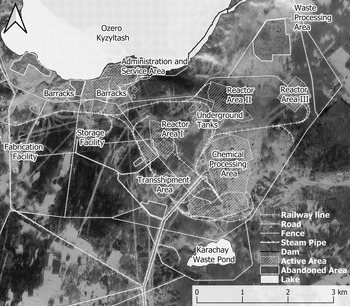
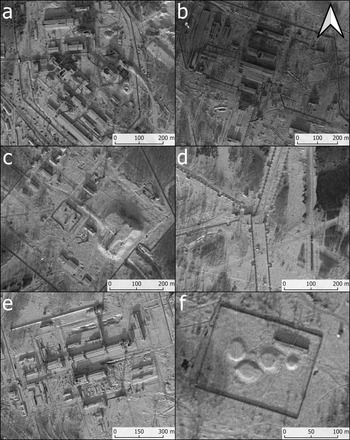
The Mayak Chemical Combine was also known as Plant No. 817. In the 1960s, the facility occupied about 28 sq. km (Fig. 7). It consisted of three separate reactor areas (Fig. 8a–c) with accompanying infrastructure (Fig. 8d). The production of weapons-grade plutonium required, besides nuclear reactors, other sophisticated facilities used for chemical processing (Fig. 8e), nuclear waste reprocessing and plutonium storage. The unwanted by-products—high-level fission wastes—were stored in water-cooled underground tanks (Fig. 8f). The compound was surrounded by fences and protected by military troops who occupied barracks located on the southern bank of Kyzyltash Lake (Fig. 7).

Close-ups of the most important areas of the Mayak Chemical Combine: (a) Reactor Area I; (b) Reactor Area II; (c) Reactor Area III (large double reactor concrete hall covered with earth); (d) Steam distribution pipes; (e) Chemical Processing Area; (f) Underground water-cooled nuclear waste tanks (GAMBIT KH7, mission 4015, 26.01.1965). (United States Geological Survey.) (Interpretation based on CIA 1964a; 1967.)

The first nuclear reactor became operational as early as 1948 (Brown Reference Brown2013, 115; Cochran et al. Reference Cochran, Norris and Sukko1993, 508). The reactors built later in the 1950s were the first nuclear devices in the world that produced electricity also for civilian recipients. They were featured as examples of the ‘peaceful use of atom energy’, in contrast to that of the ‘Western capitalists’. At the time, it was alleged that the latter built their nuclear plants only with lethal purposes in mind (Brown Reference Brown2013, 133).
The development of the Mayak Combine was supported by the intelligence services, which supplied engineers with knowledge about the latest Western scientific advances. As a result, the Soviet reactors were copies of devices created by the American General Electric Company (Soran & Stillman Reference Soran and Stillman1982, 5–12). Many other crucial technological solutions were also ‘borrowed’ from the US Hanford Complex's designs. It is therefore no surprise that CIA photo interpreters who worked with satellite imagery of Mayak had only minor difficulties in identifying the most essential areas and installations.
With the copying of technological solutions, Soviet scientists repeated the same errors that Western scientists had first committed. During the process of imitation, many new mistakes were also made. Continuous satellite surveillance during the 1960s of Reactor Area III (Fig. 8c) led to the conclusion that it had been disused for a long time (CIA 1964a, 5–7; 1967). Intelligence sources mentioned the possibility of a nuclear reactor accident before 1961 (CIA 1981, 12).
A nuclear beacon
At one level, the name Mayak [Rus. Маяк, Eng. beacon], had mostly positive associations. It was a promise of a better life, development and education brought to the southern Urals’ remote areas. However, very soon it gained its sinister resonance. The plant literally flared from time to time like a beacon, due to frequent nuclear accidents. Continuous political calls for intensification of production led to uncontrolled discharges of radioactive isotopes into the air, water and earth. Both engineers working in the facility and farmers living outside the zone were exposed to elevated radiation levels (Aarkrog et al. Reference Aarkrog, Trapeznikov and Molchanova2000; Cochran et al. Reference Cochran, Norris and Sukko1993).
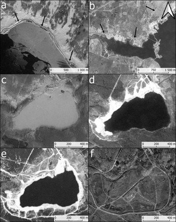
One of many faulty early designs was the reactor open cycle cooling system with radioactive water treated in artificial reservoirs, the same as in Hanford. The water was later drained directly to Kyzyltash Lake. However, such a solution was deficient and rudimentary. During the periods of intensive plutonium production, or due to system malfunctions, impure coolant was often discharged directly into the lake and spread with the flow of the Techa River (Aarkrog et al. Reference Aarkrog, Dahlgaard and Frissel1992; Reference Aarkrog, Trapeznikov and Molchanova2000; Cochran et al. Reference Cochran, Norris and Sukko1993; Soran & Stillman Reference Soran and Stillman1982, 10, 16–17; Trapeznikov et al. Reference Trapeznikov, Aarkrog and Pozolotina1994, 89–92; Reference Trapeznikov, Pozolotina and Molchanova2000). Contamination of the river valley endangered the health of the people living nearby. During the 1960s, Soviet authorities undertook a series of works to contain the situation. A new channel for the flow of the River Techa was built to reduce the fission products’ hydrological spread. The channel bypassed Kyzyltash Lake (Fig. 9a). Several dams and large artificial reservoirs were created to slow down the transmission of waterborne contamination (Fig. 9b). However, it was all done too late. The Bashkir farmers (an ethnic group of Turkic ancestry) who populated the valley already suffered from radiation sickness (Trabalka et al. Reference Trabalka, Eyman and Auerbach1979, 17–19). Most of the radionuclides were deposited within 35 km downstream from the Combine (Cochran et al. Reference Cochran, Norris and Sukko1993, 512–13; Trapeznikov et al. Reference Trapeznikov, Aarkrog and Pozolotina1994, 97). After the first cases of isotope poisoning were registered among people and cattle, they were gradually forcibly relocated, starting from 1953 (Soran & Stillman Reference Soran and Stillman1982, 14–15).
Modifications of hydrological networks in the surrounding of the Mayak Chemical Combine: (a) Man-made water channel of the Techa River (indicated by arrows), built to bypass the radioactively contaminated Lake Kyzyltash (GAMBIT KH7, mission 4015, 26.01.1965); (b) Channel (indicated by arrows) bypassing Lake Metlinskiy, and system of dams and reservoirs built to slow down the spread of contaminated waters (CORONA KH-4B, mission 1103, 10.05.1968). Gradual reclamation and backfilling of the Karachay Waste Pond: (c) Imagery collected on 26 January 1965 with no indication of any earthworks (GAMBIT KH7, mission 4015); (d) Imagery collected on 10 May 1968—backfilling of the northern and eastern sides of the pond (CORONA KH-4B, mission 1103); (e) Imagery collected on 31 May 1972 (CORONA KH-4B, mission 1117) (United States Geological Survey); (f) Contemporary close-up of the backfilled Karachay Pond (© Maxar Technologies, © Google Earth, 11.2020). (Interpretation based on CIA 1964a,b; 1967; 1981.)

The rapid increase in the manufacture of weapons-grade plutonium throughout the 1950s and 1960s led to the production of large quantities of poisonous liquid by-products. Due to a shortage of storage space, the wastes were dumped into several lakes and ravines. Lake Karachay, located on the southern edge of the Mayak Combine, was one of such sites (Figs 7 & 9c–f). The radioactive effluent was discharged there from the late 1940s to the early 1960s, making it one of the most radioactively contaminated places in the world (Cochran et al. Reference Cochran, Norris and Sukko1993, 515–19; Soran & Stillman Reference Soran and Stillman1982, 13–14). According to Western scientists’ measurements, as late as 1990, the radiation exposure level in the vicinity of the lake where the radioactive effluent was discharged was about 600 R/h (Cochran et al. Reference Cochran, Norris and Sukko1993, 518). For comparison, similar radioactivity levels occur during the early fallout about two hours after a nuclear ground explosion. Staying in such a place for about 40 minutes leads to absorption of a lethal dose.
The Karachay Lake witnessed at least two major uncontrolled aerosol dispersals of radioactive isotopes. One of these occurred in 1967, when due to an unusually dry winter and hot summer, the reservoir dried out (Aarkrog et al. Reference Aarkrog, Dahlgaard and Frissel1992, 71–2; Reference Aarkrog, Dahlgaard and Nielsen1997). Deflation of the deposits of the dry lake bed led to radioactive material being lifted by winds and carried over an area of about 1800 sq. km, affecting about 41,500 people in 63 villages (Cochran et al. Reference Cochran, Norris and Sukko1993, 518–19). The fallout of the red dust caused defoliation of the trees and other green plants.
To prevent future accidents, from 1967/68 Karachay Lake has been slowly backfilled with concrete blocks, stones and soil. The gradual disappearance of the reservoir can be traced on the satellite photographs (Fig. 9c–f). In the following years, there was a noticeable growth of a number of dirt roads leading to the site and the volume of spoil heaps in its surroundings. Due to the lethal conditions in the lake's vicinity, mainly volunteer prisoners were employed as truck drivers during this operation (Soran & Stillman Reference Soran and Stillman1982, 24–6). Those convicts were called ‘death people’ or ‘death squad’ and were promised a reduction of their long sentences if they eventually survived. When the dump trucks became too contaminated to be used further, they were reportedly pushed into the lake and covered with soil. During later years, the surroundings of the lake were also used by the Soviet Army as an ‘Active Radiological Test Site’ for imitation of the nuclear battlefield environment. Mechanized reconnaissance radiological platoons trained there in the collection of measurements, assessing the levels of radioactivity and decontamination procedures of equipment and military vehicles. According to the contemporary civilian satellite imagery, Karachay was completely backfilled as late as 2018. However, work on the site appears to be still active with ongoing earthmoving (Fig. 9f).
Landscapes of oblivion
Soviet scientist Lev Tumerman, who emigrated to Israel in 1972, reported that in 1960 he was travelling along the Chelyabinsk–Sverdlovsk road. At some point, he was passing by the area located close to Ozyorsk. This is how he described his experiences from that day:
About 100 kilometres from Sverdlovsk, a highway sign warned drivers not to stop for the next 20 or 30 kilometres and to drive through at maximum speed. On both sides of the road, as far as one could see, the land was ‘dead’: no villages, no towns, only the chimneys of destroyed houses, no cultivated fields or pastures, no herds, no people … nothing […]. What I was told by many people in Sverdlovsk and Beloyarsk, was that the fallout was a consequence of a major nuclear explosion on a military nuclear plant near Kyshtym. (Soran & Stillman Reference Soran and Stillman1982, 4–5)
The information given by Tumerman surprisingly accurately matches the deserted zone near the Mayak Chemical Combine. There is only one direct road between Sverdlovsk and Chelyabinsk. It runs about nine kilometres to the northeast outside the area of the study presented in Figure 4. Almost precisely 100 km to the south from Sverdlovsk, between the villages of Allaki and Malyy Kuyash, the M5/M36 Road crosses a zone, about 15 km wide, which remains uninhabited up to the present day. This may suggest that the radioactively polluted area was much wider than the contemporary restricted zone.
The explosion reported by Tumerman refers most probably to the events of the Kyshtym Disaster that happened on 29 September 1957. As is known today, the accident occurred due to a faulty cooling system that caused overheating and the non-nuclear explosion of the underground tanks with dried-out high-level liquid nuclear waste (Aarkrog et al. Reference Aarkrog, Dahlgaard and Frissel1992, 70–71; Cochran et al. Reference Cochran, Norris and Bukharin1995, 104–7; Reference Cochran, Norris and Sukko1993, 520–21; Trabalka et al. Reference Trabalka, Eyman and Auerbach1979, 3–4). The radioactive fallout spread within an elongated zone 300 km long and 30–50 km wide. There were 217 settlements and some 270,000 residents living within this fallout zone (Cochran et al. Reference Cochran, Norris and Sukko1993, 521; Trabalka et al. Reference Trabalka, Eyman and Auerbach1979, 1–3).
In winter 1957 (and again in early 1959), all shops in Kamensk-Uralsky, Sverdlovsk and Chelyabinsk which sold food products from the local farms were closed. Residents were ordered to return food they had already bought and were advised against purchasing anything directly from the farmers (CIA 1962, 1–2). Two days later, supplies from other parts of the Soviet Union were brought to the cities. Food was distributed directly from the vehicles, most possibly because the shops required decontamination. Social outrage was caused after it was noticed that a few party apparatchiks were carrying small radiation counters. There were reports of ‘hysterical fear’ concerning a ‘mysterious disease’ that occurred in 1957/58 in the region (CIA 1962). Other sources mentioned children's homes where, at the end of 1959, many children started having symptoms of a disease that supposedly was caused by radioactive isotope poisoning (CIA 1962, 1). There were probably countless more personal tragedies never recorded or reported. Detailed analysis of declassified satellite imagery also corroborates those testimonies.
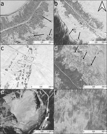
The area of about 250 sq. km of the uninhabited contaminated zone located close to the Mayak Chemical Combine was analysed for the purpose of this paper. It appears that the contaminated territory spreads northeast from the facility. There were 12 abandoned villages within the study area identified on the satellite imagery from the 1960s (Fig. 4). The CIA (1981, 8) intelligence sources reported that inhabitants of the settlements exposed to the highest doses of radiation were evacuated with some delay. Their farms were demolished to prevent future returns. Satellite photographs confirm such actions, as they show deserted villages at different stages of destruction. In some cases, buildings without roofs can be observed (Fig. 10a), while other villages were completely bulldozed (Fig. 10b, d). It is baffling to note that some of the settlements were apparently abandoned a short time before the imagery was collected. Such sites are evidently uninhabited, but the buildings were not yet torn down, and there are still roofs over them (Fig. 10c).
Examples of abandoned and demolished settlements within the study area: (a) Village at the southern bank of Lake Alabuga. Arrows indicate pits prepared for disposal of contaminated food products and killed animals (GAMBIT KH7, mission 4015, 26.01.1965); (b) Village on the southwestern bank of Lake Uruskul’. Arrows indicate pits for disposal of food products (GAMBIT KH7, mission 4015, 26.01.1965); (c) Recently abandoned village (GAMBIT KH7, mission 4015, 26.01.1965); (d) An example of the attempt to clear up radioactively contaminated area. The topsoil with radioactive isotopes was collected into low spoil heaps. For some reason, the work was never finished (GAMBIT KH7, mission 4035, 10.12.1966); (e) Stare Boloto dumping site (CORONA KH-4B, mission 1117, 31.05.1972); (f) Sparse young deciduous forests with visible traces of grubbing and ploughing marks (GAMBIT KH7, mission 4015, 26.01.1965). (United States Geological Survey.)

During the deportation of the villagers from the endangered zone, animals and crops were confiscated and destroyed on-site by the Soviet Army (Brown Reference Brown2013, 200–201; CIA 1981, 8). They were buried in long, narrow pits excavated by bulldozers—a grim reminder of the NKVD execution practices developed during the Second World War period on humans. There are also examples of small pits with spoil heaps on all sides. Soviet soldiers most possibly dug those out with shovels. The pits under discussion are present on the declassified satellite imagery and are located in the vicinities of almost all torn-down settlements (Fig. 10a–b). It seems that some of them were either never used or left open for some time, as the spoil heaps which were to be used for backfilling are often left intact.
According to the scientific observations, most of the radionuclides from the early fallout usually concentrate in the very top layers of the topsoil. Such a situation caused the danger of those particles in time becoming airborne, or spread further with water due to erosion or other environmental factors (Cochran et al. Reference Cochran, Norris and Bukharin1995, 103, 522). Therefore, groups of Soviet liquidators attempted to clean up contamination within the open areas—arable fields and pastures. It was done by removing the thin layer of topsoil and collecting it in low banks. The results of the decontamination works are visible on the declassified satellite imagery as dark-greyish areas (Fig. 10a–b). It seems that the main effort was focused on cleaning the fields closest to the evacuated villages. In several observed cases, the banks of contaminated topsoil were never removed (Fig. 10d).
Some evidence of the ground-clearance efforts appears to be relatively fresh and may still be observed in the satellite imagery collected about eight years after the Kyshtym Disaster. Thus, it is possible that those traces may be related to some other, later nuclear accidents. Similar practices of clean-up of radioactive fallout results, clearly based on the southern Urals’ experiences, were also employed during the Chernobyl events of 1986 (Brown Reference Brown2013, 282–4).
Topsoil cleaning attempts on such a large scale produced millions of cubic metres of material that had to be disposed of somewhere. The contaminated soil was used for backfilling both the Karachay Waste Pond and Stare Boloto dumping site (Fig. 10e), located only about 2.5 km to the southeast of the Mayak Combine (Cochran et al. Reference Cochran, Norris and Sukko1993, 519). Stare Boloto (area of about 9.5 sq. km) was completely backfilled before the 1960s. It was surrounded by a high earth dam to prevent the contamination spread. Judging from the contemporary civilian satellite imagery, the site is still used for waste disposal.
Chronic, uncontrolled discharges of radioactive isotopes over the years had inevitably affected the natural environment. Coniferous trees are sensitive to radioactive fallout, which causes their defoliation. They are also very efficient in trapping airborne contaminants in their crowns and reducing transmission of radionuclides from the fallout. Consequently, by autumn 1959, all pine trees in the region had died (Cochran et al. Reference Cochran, Norris and Sukko1993, 521). In all images from the middle of the 1960s, large areas of sparse young deciduous forests planted only several years earlier within the deserted zone can be identified (Fig. 10f). Beforehand, the terrain was possibly grubbed out and cleaned, but there is no available record from the time of those actions. It can also be noted that ploughing marks are still visible in the satellite photographs. Such evidence may indicate wide-ranging attempts to replace the dead pines with more resistant deciduous species of trees (e.g. birch).
Conclusions: afterimages of the Cold War
Archaeological analysis of declassified satellite imagery can add a new dimension to the studies of the Cold War secretive military sites when combined with information known previously only from written documents or eyewitness narratives. Such an approach permits building a more complete image of the past. The research presented in this paper shows that sites closed to the public and yet interesting for scientific reasons are not entirely off-limits for archaeological investigation. With the aid of available intelligence sources, it is possible to build a relatively comprehensible narrative around them. The airborne perspective helps in a better understanding of the material outcomes of past human actions. To a certain extent, it facilitates analysis of the after-effects of nuclear disasters and their impact on the local population and the landscape. Intelligence satellite images are often the only surviving (or accessible) visual proofs of events important to the whole of humankind. Thus, in my opinion, their interpretation should not be reduced to a simple factual analysis of the registered material relics, but approached from a broader socio-political perspective. The outcomes of such studies can initiate a general reflection on humankind's condition and its ability to cause havoc. They can also be used as a well-established argument in the public debate about the consequences of nuclear weapons production, testing and proliferation.
However, an airborne perspective proposed here is also sterile, convenient, artificial and dehumanizing. Beyond every ruin of a forced labour camp, every abandoned village or dying forest and polluted lake, there are countless individual human tragedies and losses. Yet this drama's main actors are utterly absent from the picture, like the ghosts invisible to the enemy ‘spy in the sky’. In this context, archaeological narratives are merely mimicry of the past. They present selective, fragmented and blurred images. Moreover, contemporary humans often perceive such a legacy more as a kind of oddity than a relic of something that really happened. It is just one of many uncanny, disturbing stories told for amusement.
The cognitive wealth of the presented satellite photographs is astonishing, but most certainly, it has not been fully exploited in this paper. According to the serendipity effect and mechanisms of the hermeneutic circle, interpretation is a never-ending process. There are also problems with the precise chronology of observed phenomena. The earliest available satellite images were collected more than a decade after the Mayak Chemical Combine became fully operational. The scope of registered landscape changes also suggests that we are dealing with the accumulation of effects of the long-term, continuous, moderate spread of radioactive contamination, not with the consequences of a single, large-scale nuclear event. It is also important to mention that dozens of minor accidents did not leave any footprint in the landscape, and could not be identified.
According to the declassified record, the CIA was well aware of the scale of the Kyshtym Disaster almost immediately after it occurred. However, its specialists repeatedly advised the state officials not to release to the public any collected intelligence regarding it. In the opinion of the Agency's analysts, this could ‘influence in a harmful way an intensive debate currently going on in the US on the safety of nuclear power and the problem of long term storage of radioactive waste’ (CIA 1978, 2). To undermine Medvedev's words, it was often publicly stated that his suppositions about the Kyshtym Disaster were ‘greatly exaggerated’, and he was ‘clearly in error’ because a massive explosion of nuclear waste is ‘a scientifically unbelievable event’. Some of the Western scientists also dismissed those claims as ‘science fiction’ and ‘rubbish’ (Dickson Reference Dickson1989).
It is worth noting that Z.A. Medvedev's writings were never directed against the development of civilian use of nuclear power, nor did he ever condemn advances in any other fields of science. His criticism concerned the Soviet approach to scientists, political and ideological oppressions, and enforced disobedience of the most basic safety rules. In many ways, this voice of reason remains relevant up to the present day. Once more, the opinion that science should conform to politics, ideology, and in some cases also to religion is gaining popularity among political elites. What is significant is that it also happens in the countries that are supposedly members of the democratic world and should be free of such convictions. The organization, funding and evaluation of scientific research is increasingly being subordinated to political dictates. Science is becoming, before our eyes, a blunt instrument for enforcing and consolidating the reason of the state. The time for scientific dissidence is again upon us.
Acknowledgements
I want to thank Rog Palmer for his valuable comments and Paul Barford for his suggestions and the linguistic proofreading.