INTRODUCTION
Although the timing and extent of advance and retreat of the Cordilleran Ice Sheet (CIS) in the Pacific Northwest is well documented along its southern and northern margins (e.g., Clague et al., Reference Clague, Armstrong and Mathews1980, Reference Clague, Mathewes, Guilbault, Hutchinson and Ricketts1997; Hicock et al., Reference Hicock, Hebda and Armstrong1982; Jackson et al., Reference Jackson, Ward, Duk-Rodkin and Hughes1991; Easterbrook, Reference Easterbrook1992; Clark et al., Reference Clark, Clague, Curry, Dreimanis, Hicock, Miller and Berger1993; Hebda et al., Reference Hebda, Howes and Maxwell1997; Barrie and Conway, Reference Barrie and Conway1999; Clague and James, Reference Clague and James2002; Kovanen and Slaymaker, Reference Kovanen and Slaymaker2004a, Reference Kovanen and Slaymaker2004b; Lakeman et al., Reference Lakeman, Clague and Menounos2008; Taylor et al., Reference Taylor, Hendy and Pak2014), little is known about the pattern of retreat along the central coast of British Columbia (BC) (e.g., Clague, Reference Clague1985; Luternauer et al., Reference Luternauer, Conway, Clague and Blaise1989; Barrie et al., Reference Barrie, Bornhold, Conway and Luternauer1991). This gap in knowledge is likely because of landform preservation and exposure in the region, with the majority of the landforms associated with the western termini of the CIS on the central coast currently submerged at the edge of the continental shelf, in Queen Charlotte Sound (cf. Clague and James, Reference Clague and James2002). In addition, the BC central coast is well forested, in places has high relief, and is sparsely populated, leading to difficulties with access and landform identification from conventional remotely sensed data sources (e.g., aerial photography and satellite imagery). Accessibility to this coastline has recently been improved, with the founding of the Hakai Institute on Calvert Island (Fig. 1), which supports several collaborative geographic, geologic, biological, and archaeological research projects along the central coast.
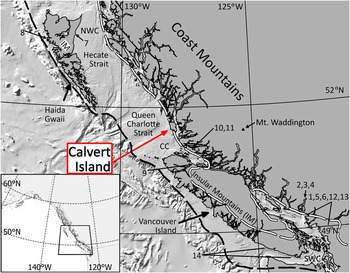
Study area (Calvert Island) on the central coast of British Columbia. Inset map shows the location of Figure 1 (black square). Source areas for Cordilleran ice include the Coast Mountains and the Insular Mountains on Haida Gwaii and Vancouver Island. Dashed lines show ice extent at the local last glacial maximum (18 ka, black) and the early stage of deglaciation (14 ka, white) from Taylor et al. (Reference Taylor, Hendy and Pak2014). Regions of paleoclimate reconstructions using lake cores (referred to in the “Discussion”) are provided: CC, central coast and northern Vancouver Island; NWC, the northwest coast; SWC, southwest coast (including the Fraser and Puget lowlands). Sites presented in Figure 6 are numbered as follows: (1) Locations of Sumas phases II, III, and IV (Kovanen and Easterbrook, Reference Kovanen and Easterbrook2002). (2) Squamish moraine (Friele and Clague, Reference Friele and Clague2002). (3) Squamish valley kame (Friele et al., Reference Friele, Ekes and Hicken1999). (4) Howe Sound moraine (McCrumb and Swanson, Reference McCrumb and Swanson1998). (5) Chilliwack Sandur (Saunders et al., Reference Saunders, Clague and Roberts1987). (6) Bradner Pit (Clague et al., Reference Clague, Mathewes, Guilbault, Hutchinson and Ricketts1997). (7) Cape Ball (Warner, Reference Warner1984). (8) Hippa Island (Lacourse et al., Reference Lacourse, Delepine, Hoffman and Mathewes2012). (9) Misty Lake (Lacourse, Reference Lacourse2005). (10) Woods Lake (Stolze et al., Reference Stolze, Roe, Patterson and Monecke2007). (11) Tiny Lake (Galloway et al., Reference Galloway, Doherty, Patterson and Roe2009). (12) Marion Lake (Mathewes and Heusser, Reference Mathewes and Heusser1981). (13) Mike Lake (Pellatt et al., Reference Pellatt, Mathewes and Clague2002). (14) East Sooke Fen, Pixie Lake, and Whyac Lake (Brown and Hebda Reference Brown and Hebda2002). (For interpretation of the references to color in this figure legend, the reader is referred to the web version of this article.)

The chronology of growth and decay of the CIS for all of BC is summarized by Clague and James (Reference Clague and James2002), and more recently by Menounos et al. (Reference Menounos, Osborn, Clague and Luckman2009), with most of the evidence for ice extent coming from southern BC and Washington State (Booth et al., Reference Booth, Troost, Clague and Waitt2003). Evidence for sporadic or thin ice cover at the last glacial maximum (LGM) exists in several places along the western CIS margin. In northwest BC, biological refugia were postulated in Hecate Strait, on nunataks in the Insular Mountains, and on headlands, islands, and in interfjord ridges on the west coast (Clague et al., Reference Clague, Mathewes and Warner1982). The western terminus of the CIS (e.g., Margold et al., Reference Margold, Jansson, Kleman, Stroeven and Clague2013; Taylor et al., Reference Taylor, Hendy and Pak2014; Fig. 1), with a postulated refugium on Brooks Peninsula (Hebda et al., Reference Hebda, Howes and Maxwell1997), suggests that ice did not quite reach the edge of the continental shelf along the entire west coast of Vancouver Island. Along the central coast of BC, ice advanced down fjords and valleys of coastal mountains and extended out on to, and in places to the edge of, the continental shelf (Josenhans et al., Reference Josenhans, Fedje, Conway and Barrie1995). The extent of ice cover on the continental shelf between Haida Gwaii and northern Vancouver Island is still poorly constrained, with most of the data for the region coming from Hecate Strait and northeast Vancouver Island (Barrie et al., Reference Barrie, Hetherington and Macleod2014). Geomorphic evidence exists for ice streaming onto the shelf edge in several large glacially carved troughs (Luternauer et al., Reference Luternauer, Conway, Clague and Blaise1989; Mathews, Reference Mathews1991), but till was either not deposited in them or eroded during periods of subsequent sea-level change that may have exposed the troughs to wave and tidal erosion (Barrie et al., Reference Barrie, Bornhold, Conway and Luternauer1991). Ice from the northern Coast Mountains that had previously coalesced with glaciers from Haida Gwaii started to retreat between 18.3 and 17.0 cal ka BP (Blaise et al., Reference Blaise, Clague and Mathewes1990), and between 16.0 and 14.2 cal ka BP the ice sheet had retreated from Hecate Strait with mainland ice confined to fjords (Clague, Reference Clague1985). In general, coastal portions of western North America once covered by the CIS were completely free of ice by 15.9 to 15.2 cal ka BP (Kelly, Reference Kelly2003).
The decay of the CIS was repeatedly interrupted by glacier still stands and localized readvances (e.g., Saunders et al., Reference Saunders, Clague and Roberts1987; Clague et al., Reference Clague, Mathewes, Guilbault, Hutchinson and Ricketts1997; McCrumb and Swanson, Reference McCrumb and Swanson1998; Friele and Clague, Reference Friele and Clague2002; Kovanen and Easterbrook, Reference Kovanen and Easterbrook2002). Climate may have been a mechanism for ice readvance, as there are several well-documented post-LGM cold-climate periods, for example the Older Dryas (14.1 cal ka BP), inter-Allerød (13.2 cal ka BP), and Younger Dryas (12.3 cal ka BP) (Lowe et al., Reference Lowe and Hoek2001), or the Heinrich event 1 period (17.5–14.7 cal ka BP) marked by warm-cold oscillations (Kiefer and Kienast, Reference Kiefer and Kienast2005), that have affected the Pacific Northwest (Kienast and McKay, Reference Kienast and McKay2001; Menounos et al., Reference Menounos, Osborn, Clague and Luckman2009). For instance, the Younger Dryas, which may have been a global phenomenon, has been linked to several advances along the CIS margin (e.g., Mathewes et al., Reference Mathewes, Heusser and Patterson1993; Gosse et al., Reference Gosse, Evenson, Klein, Lawn and Middleton1995; Lowell et al., Reference Lowell, Heusser, Andersen, Moreno, Hauser, Heusser, Schlϋchter, Marchant and Denton1995; Benson et al., Reference Benson, Burdett, Lund, Kashgarian and Mensing1997; Hendy et al., Reference Hendy, Kennett, Roark and Ingram2002). Lakeman et al. (Reference Lakeman, Clague and Menounos2008) provides a review of CIS ice advances that occurred during the Younger Dryas interval, and more recently, Mood and Smith (Reference Mood and Smith2015) document a Younger Dryas–aged glacial advance on Mt. Waddington, 200 km east of our study area on Calvert Island. Some disagreement exists on the timing and extent of what is termed the “Sumas stade” (see Clague et al., Reference Clague, Mathewes, Guilbault, Hutchinson and Ricketts1997; Clague et al., Reference Clague, Mathewes, Guilbault, Hutchinson and Ricketts1998; Easterbrook and Kovanen, Reference Easterbrook and Kovanen1998), a period of late Pleistocene local ice advance along the southern CIS margin. Kovanen and Easterbrook (Reference Kovanen and Easterbrook2002) argue for three or four advances in the Fraser and Puget lowlands that are coincident with the inter-Allerød cold period and Younger Dryas data. In contrast, Clague et al. (Reference Clague, Mathewes, Guilbault, Hutchinson and Ricketts1997) and Hicock et al. (Reference Hicock, Lian and Mathewes1999) present differently timed, nonclimatological mechanisms for ice readvance (discussed subsequently). Friele and Clague (Reference Friele and Clague2002) found evidence that glaciers advanced twice in Howe Sound, a fjord in the Coast Mountains immediately northwest of the Fraser Lowland, and that the advance may correspond with the Sumas event and Younger Dryas cold-climate period. Pre–Younger Dryas glacial advances have also been identified in the southern Canadian and northern American Rocky Mountains (Osborn and Gerloff, Reference Osborn and Gerloff1997) and are reviewed by Menounos et al. (Reference Menounos, Osborn, Clague and Luckman2009).
The previously mentioned glacial readvances may have been triggered by changes in climate, but others may have been the result of other mechanisms, associated relative sea-level changes (which include eustatic and isostatic effects), grounding line flux, and changing subglacial conditions (e.g., Hicock et al., Reference Hicock, Lian and Mathewes1999; Kovanen and Slaymaker, Reference Kovanen and Slaymaker2003; Menounos et al., Reference Menounos, Osborn, Clague and Luckman2009). For example, Clague et al. (Reference Clague, Mathewes, Guilbault, Hutchinson and Ricketts1997) provide evidence for two “Sumas” advances older than the Younger Dryas cold-climate period. Hicock et al. (Reference Hicock, Lian and Mathewes1999) suggest that deformable bed conditions (soft, wet, muddy substrate) present in the now-subaerial Fraser Lowland may have been another factor contributing to localized ice advance. Menounos et al. (Reference Menounos, Osborn, Clague and Luckman2009) discuss how topographic effects, such as elevation-driven resurgent alpine glaciers that came in to contact with stagnant ice of the CIS, or small aspect-driven cirque glaciers forming in basins that were previously ice free, may also have contributed to localized ice readvance already initiated by some other driving force.
Calvert Island contains several distinct landforms and a sedimentary sequence that provides data on the nature and timing of an advance and retreat of glaciers in the region during the overall retreat of the CIS. In this article, we (1) describe and interpret the sedimentary sequence, (2) present information on the age of the glacial advance that deposited the sediments, (3) describe the paleoecology inferred from organic material found in sediments deposited just prior to the advance, and (4) discuss the implications of these data as they pertain to regional geomorphology, climate, ecosystems, and deglaciation in coastal BC and other regions of the CIS.
Study area
Calvert Island is located on the central coast of BC in Queen Charlotte Sound, about 70 km northwest of Vancouver Island and about 200 km southeast of Haida Gwaii (Fig. 1). Bedrock is composed mainly of early Cretaceous tonalite, quartz diorite, granite, granodiorite, and diorite of the Calvert Island Pluton with diorite-dominated rocks of unknown age cropping out mostly in the central, eastern, and southeastern parts of island (Roddick, Reference Roddick1996). Relief in the area ranges from mountains as high as 1017 m (Mount Buxton) to relatively flat alluvial plains formed in glacial sediments near present sea level. The western coastline is predominantly bedrock, with accretionary shorelines characterized by cobbly to sandy embayments (with localized coastal dunes), tombolos, and spits. Exposed glacial sediments on Calvert Island are largely confined to the central-west portion of the island, with the landscape otherwise notably absent of much surficial cover, particularly in the northwest. Moraines are small (generally less than 5 m high and 25–35 m wide), and most are isolated, except along the west central coast where a series of what are likely recessional moraines exist. Small areas of glaciofluvial outwash exist in the northwest part of the island adjacent to the moraines. Raised (relict) shorelines and extensive relict beach plains also exist; however, sea level has fluctuated less than a few meters since near the end of the late Pleistocene (McLaren et al., Reference McLaren, Fedje, Hay, Mackie, Walker, Shugar, Eamer, Lian and Neudorf2014). This is a postglacial relative sea-level response markedly different from those in nearby areas on the coast where fluctuations of more than a hundred meters were common (Shugar et al., Reference Shugar, Walker, Lian, Eamer, Neudorf, McLaren and Fedje2014).
METHODS AND DATA
Geomorphology and geography of surficial deposits
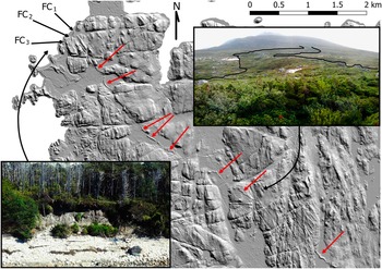
Information on surficial landforms and related deposits was collected using airborne LIDAR (light detection and ranging) data collected in August 2012 from a fixed-wing aircraft at an altitude above ground level of 1150 m (requests for these data can be made at http://data.hakai.org/). The average below-canopy (“ground”) point density throughout the study region was approximately 1 point/m2; however, in some areas the point density was closer to 2 points/m2. These data were used to create a 2-m-resolution bare-earth digital elevation model, using the nearest neighbor interpolation method and the intercell average elevation (Fig. 2). Coincident 0.15-m-resolution digital orthophotos were also collected and used to aid in analysis. These data were largely used to identify and delineate glacigenic features on the landscape, including a semicontinuous moraine that extends across the northwest of Calvert Island (Fig. 2).
Bare-earth LiDAR hill shade of the northwest corner of Calvert Island. The locations of the three stratigraphic sections (FC1, FC2, and FC3) are shown. Red arrows highlight the semicontinuous moraine that extends southeast from these exposures. This moraine is shown (and outlined) in the upper inset photo. The lower inset photo is an oblique air photo showing the coastal north–northwest facing bluff that contains section FC1; the orientation of the photo is looking south–southeast. (For interpretation of the references to color in this figure legend, the reader is referred to the web version of this article.)

Stratigraphy and geochronology
The stratigraphy exposed at Foggy Cove, a wave-cut bluff on northwest Calvert Island, was analyzed in three sections (FC1, FC2, and FC3; Figs. 2–4) between 2012 and 2014. Lithostratigraphic units were identified based on color, texture, sedimentary structures, clast lithology and shape, and the nature of contacts between units. The strike and dip of planar structures and the trend and plunge of stone long (a) axes (clast fabrics) in diamictons were measured using a Brunton structural compass or a Suunto compass with a dip needle. Only clasts with a:b ratios ≥1.5:1 were measured, and an attempt was made to keep a single fabric measurement (consisting of >50 individual clasts) within a zone of 2 m2. Fabric data were analyzed using Stereonet 9 (Allmendinger et al., Reference Allmendinger, Cardozo and Fisher2012; Cardozo and Allmendinger, Reference Cardozo and Allmendinger2013) and the orientation tensor (eigenvalue) method (Mark, Reference Mark1973). The results were plotted as contoured lower hemisphere equal-area projections. The size, shape, and lithology were recorded for clasts in diamicton used in fabric analysis that were >0.01 m in diameter (b-axis), and matrix samples (or a bulk sample, if clasts were <0.01 m diameter) were collected from all sedimentary units for grain-size analyses. Grain-size analysis was performed by mechanical sieving using W.S. Tyler Canadian Standard Sieve Series at quarter-φ intervals for grain sizes between −1 and 4
 $$\rphi $$
(2 and 0.062 mm), and a Malvern Mastersizer laser granulometer for grain sizes between 3.5 and 10
$$\rphi $$
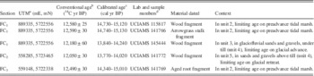
(0.075 and 0.001 mm). Overlap was used to determine the offset, if any, of the two methods for grain-size determination (Shugar and Clague, Reference Shugar and Clague2011). The method of Folk and Ward (Reference Folk and Ward1957) was used for analyzing grain-size distributions and for derivation of grain-size classes and physical descriptions. Table 1 provides the metadata and ages of samples collected for accelerator mass spectrometry (AMS) radiocarbon dating, with a description of sample location and type given in the “Results” section.
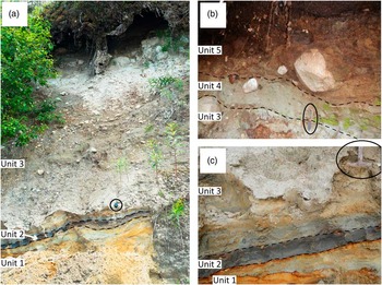
(color online) The lithostratigraphic units described in this study: (a) Section FC1, with camera lens cap for scale. (b) Section FC3, with pocket knife for scale. (c) Close-up view of the base of section FC1, with rock hammer for scale.

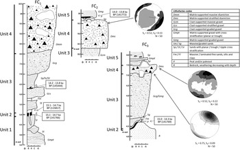
Stratigraphic logs of three key sections exposed at Foggy Cove (FC1, FC2, and FC3). Stone a-axis fabric diagrams shown with number of clasts measured (N) and eigenvalues S1 and S3. Radiocarbon ages are shown calibrated, with the laboratory number in brackets (Table 1).

Limiting radiocarbon ages of glacial readvance on Calvert Island.

a NAD83 zone 9N. UTM, Universal Transverse Mercator conformal projection; mE, meters east; mN, meters north.
b Ages measured at UCIAMS and reported with laboratory error precision of 1σ. Samples were selectively subsampled, identified, and cleaned at the Paleotec Services laboratory by A. Telka.
c Calibrated age range given in years before AD 1950. All calibration was done using Calib 7.0 (Stuiver et al., Reference Stuiver, Reimer and Reimer2013) and the IntCal calibration data set, with a lab error multiplier of 1. Calibrated (calendar age) ranges are reported at 2σ.
d UCIAMS refers to the W.M. Keck Carbon Cycle Accelerator Mass Spectrometry Laboratory.
Macrofossils
A 0.05 m3 cube of fibrous, organic-rich material was collected from silt and fine sand at the base of section FC1 (Fig. 3, unit 2) and was analyzed for plant and insect macrofossils. The procedure for isolating macrofossils for analysis involved the standard technique of wet sieving with warm tap water (Warner, Reference Warner1990; Birks, Reference Birks2001) with slight modifications: the sample was soaked in warm water, and the organic material floating on the surface was gently decanted into a 100 mesh Canadian Standard Tyler series sieve (mesh opening 0.15 mm). The remaining sample was sieved through nested 20 and 40 Canadian Standard Tyler series sieves (mesh opening 0.85 mm and 0.425 mm, respectively) using a swirl technique to separate the organic fraction from the fine sand mineral component. The float fraction (>0.15 mm) and all material greater than 0.425 mm were examined using a binocular microscope, and plant and insect fossil remains were isolated for identification and for potential AMS 14C dating.
RESULTS
Lithostratigraphic units—descriptions and chronology
Sedimentary exposures on Calvert Island are uncommon, areas of exposed bedrock with little to no surficial sediments being common. Wave-eroded dunes are, in places, found landward of sandy beaches in the northwest of the island, and mass wasting on the central-east mountainous areas has exposed thin sediment covers consisting of silt, sand, and gravel. The thickest exposures of sediments found to date (>40 m), interpreted to be glacigenic, are exposed in the sea cliffs behind 3 Mile Beach on the west coast near the center of the island (Fig. 2). These exposures are difficult to access but are a target for future work.
The sediments in Foggy Cove sections FC1, FC2, and FC3, can be divided into five lithostratigraphic units (Figs. 3 and 4), and these are described and interpreted subsequently, with unit numbers increasing from the base. Andrews and Retherford (Reference Andrews and Retherford1978) described and interpreted similar stratigraphy in the northwest part of Calvert Island close to the site used for this study; however, they did not provide precise coordinates for their sections. Our field observations do not closely match theirs, which included ~3 m of till at elevations where the sediments are determined to be outwash sand and gravel in this study (3.5–6.5 m above sea level) and a radiocarbon age from bulk organic material collected at the top of their section (6780 ± 360 BP; GaK-5302), which Andrews and Retherford (Reference Andrews and Retherford1978) suggest was likely a minimum age because of contamination from groundwater exchange (refer to Fig. 4 from this study and fig. 2A from Andrews and Retherford [Reference Andrews and Retherford1978] for differences in stratigraphic and sedimentologic observations at Foggy Cove). These differences may be attributable to more than three decades of bluff erosion.
Unit 1 is 1–3 m thick and is exposed for several tens of meters along the bluff. The variable apparent thickness is because of an overall strike and dip of the beds of 350°/25°, which results in a thinner exposure to the east as the unit dips into the modern beach. It is absent at section FC3, as unit 2 at FC3 section lies directly on bedrock. Unit 1 was not observed at section FC2, but it may underlie slumped sediment at the base of the section. Unit 1 consists of three beds. The lowest bed, 0.75 m thick, is mostly matrix supported and consists of subrounded pebbles of mixed lithology that grade into very poorly sorted (polymodal), clast-supported, subangular gravel. Trough and planar cross bedding were observed in this bed. A lower contact was not observed as the unit becomes obscured at the base by modern beach and colluvial deposits. The spaces between the pebbles are filled with a pinkish-gray (5YR 6/2) coarse sand matrix, and in rare places, the matrix is absent of clasts and shows horizontal laminae that are black (10YR 2/1). The middle bed, 0.40 m thick, consists of trough and planar cross-bedded, moderately sorted, coarse sand with a few lenses of gravel. The sand is red (2.5YR 4/8), and in places, thin cemented zones are found between bedding planes. Channel bed erosion and subsequent infill is observable at several locations in this bed. The lower contact is sharp and undulatory. The upper bed of unit 1, 0.65 m thick, has a sharp, highly undulatory lower contact. It consists of inversely graded light-red (2.5YR 6/6) and light-reddish-gray (2.5YR 7/1) sand, with the gray tones dominant in the finer fraction of sediment (fine sand and silt). The sediment has a trimodal size distribution and is poorly sorted, containing some silt and gravel.
Unit 2 is composed of one bed that is 0.10 m thick. It is laterally uniform in thickness and composition and was observed at sections FC1 and FC3. The only difference between the two sites occurs below unit 2, where at FC3 the contact is more undulatory and unit 1 is absent. Unit 2 is organic rich (80% organic matter by volume) and contains very dark-gray (10YR 4/1), poorly sorted, very fine sand. Organic material is spread evenly throughout the unit and consists mainly of compacted, matted vegetation containing macrofossils. Minor gravel exists as outsized lonestones; there is a high proportion of silt (36%), and there are no observable sedimentary structures. Three samples of this unit were collected for radiocarbon dating (Table 1): two samples were extracted from bulk sediment collected vertically across the unit at FC1 and FC3 (sample UCIAMS [W.M. Keck Carbon Cycle Accelerator Mass Spectrometry Laboratory] 141766 was collected near the base of the unit, and sample UCIAMS 141769 was collected near the top, both representing a time of death for marsh vegetation), and a wood fragment (sample UCIAMS 115817) was collected from the middle of the unit at FC1. This bed has the best chronological control, with three radiocarbon ages (Table 1, Fig. 4) that collectively constrain its deposition to between 15.1 and 14.3 cal ka BP.
Unit 3 is between 2 and 3 m thick and consists of several (>5) beds with particle sizes ranging from medium silt to cobbles, with each individual bed ranging from 0.10 m to 1.5 m thick. The lower contact of unit 3 is gradational and no more than 1 cm thick. The sediment type in the lowest bed (which is 0.10 m thick) is light-gray (10YR 7/1), poorly sorted medium silt with minor (0.2%) gravel and sand. Little to no organic material is observed in the lower bed of this unit. At one location, sediments at its base have been injected downward ~1 m, through unit 2 and into unit 1. Above the lowest bed, a series of beds that coarsen upward (Figs. 3 and 4) occur. Vertical organization of the beds varies laterally across the exposure, but generally beds above the lowest one are composed of moderately well-sorted, light-brown (7.5YR 6/3) medium sand that has trough (major) and planar (minor) cross bedding. Above the cross-bedded sands, beds are gray (5Y 5/1) and consist of clast-supported, cobble diamicton with minor boulder-sized clasts (>0.5 m diameter) in a poorly sorted, very coarse sand matrix. In places, along the exposure, alternating beds of clast-supported gravel and well-sorted sands are observed, and in others, reverse grading is observed. The sediments within the alternating beds typically have the strongest expression of cross bedding, and their thicknesses vary across the exposure from ~0.1 to ~3 m, although generally the beds containing larger clast sizes are thicker. Cobbles are subrounded and dominated by the local granodiorite lithology with minor amounts (10%) of allogenic basalt and greenstone clasts. Striae or stoss-lee features on clasts indicative of subglacial transport or deposition are absent. In the middle of unit 3 (1.4 m above the lower contact) is an undulatory bed of organic-rich, dark-reddish-brown (5YR 2/2) fine sand that has well-preserved, sharp lower and upper contacts. At the upper and lower contacts of the organic-rich sediments are beds of light-gray (10R 7/1) fine sand with planar cross bedding. Continuity of the bed and preservation of the contacts suggest in situ deposition. Radiocarbon dating of a wood fragment indicates that the organic-rich layer contains plant material that had died between 14.2 and 13.8 cal ka BP (sample UCIAMS 145444; Table 1, Fig. 4).
Unit 4 consists of a single bed, up to 1.5 m thick, of clast-poor, highly compacted, massive, matrix-supported diamicton. The lower contact is undulatory and sharp. Clasts are subangular, a large proportion (65%) are subspherical, few had stoss-lee (bullet) forms, and no striations could be seen on their surfaces. Clasts ranged in size from pebbles to boulders >2 m in diameter. Clasts are largely of local provenance (80% granodiorite), but some are volcanic and metamorphic in composition. The matrix is poorly sorted, dominated by gray (5YR 6/1) fine sand and medium silt, and is notably finer than the matrix in unit 3. Pebble a-axis fabric was measured near the top of unit 4 at sections FC2 and FC3 and at the base of the unit of section FC2. The fabrics taken from the top of the unit have spread unimodal distributions with trend/plunge values of 22°/16° and 126°/9°, respectively (S1 values of 0.52); however, the fabric taken from section FC2 is a stronger (S1 value of 0.75) unimodal distribution, with the principal eigenvector (V1) plunging 24° to the northeast (33°).
Unit 5 is 0.6 m thick and has an upper contact that disappears under the overhanging root mat at both sections FC2 and FC3; the unit is not observed at section FC1. Unit 5 consists of multiple beds of planar and trough cross-bedded fine, medium, and coarse sands with minor gravel, as well as gravel beds that are matrix supported and are either graded or showing minor cross bedding. The coarse sand is reddish brown (5YR 4/4), and the medium and fine sands are gray (5YR 6/1). A few cobbles and boulders are present, and these are subrounded to rounded. The lower contact is undulatory and sharp and, in places, drapes over boulders in unit 4. Coarse sand is localized in lenses to the west of the boulders. At section FC2, an organic-rich bed containing fossil roots and wood fragments is found near the base of this unit (Figs. 3 and 4); one of the wood fragments yielded a radiocarbon age between 14.0 and 13.8 cal ka BP (sample UCIAMS 141772; Table 1, Fig. 4).
Macrofossils—unit 2
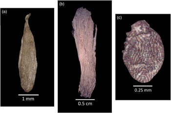
The distinctive carpels of Triglochin maritima (seaside arrowgrass) (Fig. 5a), an aquatic or semiaquatic grass of wet habitats of tidal marshes, mudflats, ponds, and wet meadows, are fairly abundant in unit 2. Equally abundant are seaside arrowgrass stalk fragments (Fig. 5b), of which one was radiocarbon dated from this unit (Table 1; 15.1 to 14.7 cal ka BP, sample UCIAMS 141766). Next abundant are Carex lenticular type (sedges) achenes, a grasslike perennial herb found primarily in wetlands such as marshes, calcareous fens, bogs, peatlands, ponds, stream banks, riparian zones, and alpine tundra (Jermy et al., Reference Jermy, Simpson, Foley and Porter2007). Minor occurrences of other plants and shrubs include Fragaria chiloensis (coastal or beach strawberry) and Empetrum nigrum (crowberry). Beach strawberry is common in present-day coastal BC, being found on dry to mesic sand dunes and rocky coastal bluffs just above high tide. The decumbent evergreen crowberry shrub can be found growing in the lowland to alpine zones in wet to moist bogs, meadows, open forests, alpine fellfields, and cliffs in BC. Mosses are not abundant with only stem fragments of a few species being recovered, none of which were Sphagnum sp. (sphagnum moss). Noteworthy is the absence of any macrofossil remains of treed species.
(color online) Examples of key macrofossils collected from unit 2. (a) Carpel of Triglochin maritima (seaside arrowgrass). (b) Stalk fragment of T. maritima. (c) Fossil Ameronothrus lineatus (oribatid mite).

Fossil insects include Saldidae (shore bugs), Cicadellidae (leafhoppers), and Hydraenidae—Ochthebius sp. (minute moss beetle). Shore bugs inhabit beaches and shorelines of lakes, streams, and oceans, as well as springs, bogs, and salt marshes. They are able to survive in or on the water surface or when they are submerged on beaches at high tide (Usinger, Reference Usinger1968). Members of the minute moss beetles are found at the water’s edge in both lacustrine and fluvial habitats, as well as intertidal areas (littoral zone substrata). Many Diptera (fly) pupae of one type occur in unit 2. Although the pupae could not be identified, they most likely belong to flies that live and forage along the wrack zone just above the mean high-tide line where debris is deposited on the sand. Arachnids included Erigone sp. (dwarf spider) and, of particular interest, the oribatid mite Ameronothrus lineatus. Species of Erigone are small spiders that live near water where they place their 5 cm square webs between grasses (Bristowe, Reference Bristowe1958). Some species are found on the seashore (e.g., Erigone arctica) where they spin webs in cavities of vegetation and amongst pebbles where the sea covers them at high tide. They survive under water with air stored in their book lungs and trachea (Bristowe, Reference Bristowe1958). Abundant A. lineatus fossils were identified (Fig. 5c)—a species that is common along seashores in the littoral zone (Hammer, Reference Hammer1952) and can be found between the high-water mark (rarely inundated) to the upper subtidal zone areas that are permanently submerged. A. lineatus has an Arctic and subarctic distribution and occurs today in coastal areas in the Yukon Territory, Northwest Territories, and Nunavut, but not in present-day BC; it can tolerate extreme cold weather (Coulson and Birkemoe, Reference Coulson and Birkemoe2000).
DISCUSSION
Unit interpretation
Sediments exposed at the base of the coastal bluff at Foggy Cove (unit 1) were deposited in a fluvial or deltaic environment, or possibly a transition between the two as grain size decreases upward in the unit. Trough cross-bedded sand and gravel that generally fine upward and contain erosional and undulatory contacts between the beds indicate a migrating channel system, consistent with a braided stream network. The silt and fine sand near the upper portion of the unit represents a more quiescent, or distal, zone of deposition; however, poorly sorted sands, gravels, and silts suggest a varying energy regime consistent with migrating channels. This sequence indicates either a minor transgression of sea level (cf. McLaren et al., Reference McLaren, Fedje, Hay, Mackie, Walker, Shugar, Eamer, Lian and Neudorf2014) or a change in the basin configuration (such as the development of a marsh), with fluvial sediments being deposited in a gradually deepening water column.
Unit 2 was deposited in a tidal marsh, as evidenced by the fine-grained sediments and fossil assemblage. The modal grain size is a very fine sand, suggesting that the sediments in this unit were deposited in a low-energy setting. The rare clasts of gravel may have a glacigenic origin (ice-rafted debris), a low-energy fluvial origin (flood events depositing rare clasts), or a coastal origin, such as a marsh, where storm events transport rare clasts much farther inland. The floral and faunal assemblages from unit 2 portray a coastal, tidally submerged, grass-sedge wetland marsh within a protected embayment. Water within the embayment was shallow with frequent fluctuations of water levels. Freshwater input was probably limited to runoff and precipitation. The wetland was subjected to periodic rise and fall of tidal waters so that the chemistry of the water was saline or brackish. Seaside arrowgrass and some species of sedges are capable of tolerating halophytic conditions. Many of the plants in unit 2 have distributions that are circumpolar, living in the north at or above tree line including the Arctic and subarctic. Seaside arrowgrass distribution is circumpolar growing north to, or slightly beyond, the limit of trees. E. nigrum (crowberry) is circumpolar occurring as far north as the Arctic islands and Greenland. F. chiloensis (coastal strawberry) is limited to Pacific coastal areas as far north as Alaska, including into the Aleutian Islands. Of significance is the oribatid mite, A. lineatus, which is presently found only in the coastal regions of the Arctic and subarctic. This indicates climate was much colder at Foggy Cove than present when unit 2 was deposited. Thus, based on the geochronology and paleoecology, unit 2 was deposited in ice-free conditions when climate was similar to that of the modern Arctic.
The moderate sorting and upward coarsening nature of the sediments, together with the presence of trough and planar cross bedding, is consistent with unit 3 being deposited by meltwater flowing from an advancing glacier. The very fine-grained sediment at the base of the unit suggests deposition in standing water when glaciers were distal from the site. The interbedding of coarser and finer beds suggests a fluctuating energy regime likely associated with a migrating channel in a braided stream or on an outwash plain. The injection feature at the base of FC1 indicates that the lower bed of this unit had a significant pore-water content and that it experienced loading, which is consistent with overriding ice. The organic-rich layer deposited on cross-bedded fine sand likely formed when vegetation grew in an abandoned channel or on a point bar that was subsequently buried as the channel migrated. Based on the interpretation of this unit and the age determined from radiocarbon sample UCIAMS 145444 (Table 1, Fig. 4), these sediments were deposited between 14.2 and 13.8 cal ka BP.
The presence of a fine (massive) matrix supporting large clasts, a strong unimodal clast a-axis fabric near the lower contact, and a sharp (erosional) lower contact, suggest that unit 4 is a subglacial till. This till would have been formed from ice that overrode and reworked the underlying glaciofluvial sediments, as well as from sediment derived from relatively local bedrock sources. The lack of abundant abrasion features on stones, and two weak pebble a-axis fabrics near the top of the unit, may cast some doubt on this interpretation. However, a paucity of glacigenic features on stones in diamictons dominated by coarse-grained lithologies (e.g., granites) and weak fabrics in stone-rich diamictons where clast collisions do not allow for the development of strong fabrics have been noted in other studies (e.g., Hicock and Lian, Reference Hicock and Lian1999; Neudorf et al., Reference Neudorf, Brennand and Lian2015).
Trough cross bedding, a sharp (erosional) lower contact, a multimodal grain-size distribution, and subrounded to rounded clasts suggest that the sediments in unit 5 were fluvially deposited. The organic-rich layer with fossil roots and wood fragments represents a paleosol that formed, or reworked organic material that was deposited, near the middle of this unit (Fig. 4). Observed in situ fossil roots and root casts suggest that the former is more likely, and thus this organic-rich layer suggests a hiatus in deposition following ice retreat between 14.0 and 13.8 cal ka BP, where the landscape at this site stabilized (Table 1, Fig. 4) and soil was able to form. The soil was eventually buried by fluvial sediments (unit 5).
Section interpretation and evidence for glacial advance and retreat
The lithostratigraphic, paleoecological, and chronological information presented previously suggests that the following sequence of paleoenvironments was present at Foggy Cove: (1) Before 15.1 cal ka BP (radiocarbon samples UCIAMS 115817, 141766, and 141769; Table 1), a fluvial environment existed that was transitioning into a deltaic environment (unit 1). (2) Between 15.1 and 14.3 cal ka BP (samples UCIAMS 115817, 141766, and 141769; Table 1), a tidal marsh was present in a cold Arctic to subarctic climate, indicated by abundant seaside arrowgrass and oribatid mites (unit 2). (3) Between 14.2 and 13.8 cal ka BP (sample UCIAMS 145444; Table 1), glaciers were advancing toward Foggy Cove, and glaciofluvial sediments were being deposited in front of the ice margin (unit 3). (4) Between 14.2 and 13.8 cal ka BP, based on bounding radiocarbon ages (sample UCIAMS 145444 below unit 4 and sample UCIAMS 141772 above unit 4; Table 1, Fig. 4), ice was present for a short period of time (at most 400 yr), depositing subglacial till (unit 4). (5) Between 14.0 and 13.8 cal ka BP (sample UCIAMS 141772; Table 1), ice retreated from the area, depositing thin beds of sand, gravel, and boulders as the ice melted (unit 5). Because there is no evidence of overturned beds, folding, major bio- or cryoturbation, or pressure-induced injection of sediment in units 3–5, there is no reason to question that, according to superposition, unit 4 was emplaced after unit 3 and before unit 5. This means that sometime between 14.2 and 13.8 cal ka BP, unit 4 was emplaced, and ice was present.
The sedimentological and paleoecological data presented here suggest that the Foggy Cove sequence represents glacial advance over a tidal marsh environment and subsequent retreat. An alternative hypothesis, however, could be that the sequence instead represents paraglacial sedimentation, and the organic units found in the middle of units 3 and 5 represent reworked organic material that were stable surfaces on a higher plateau (cf. Lian and Hickin, Reference Lian and Hickin1996). In this scenario, the diamicton found in units 3 and 4 could have been deposited as debris flows in an aggrading fluvial environment. This alternate hypothesis is not likely for several reasons. The debris flows discussed by Lian and Hickin (Reference Lian and Hickin1996) required destabilized steep slopes, which are not present in the region surrounding Foggy Cove. No beds in units 3 and 4 were observed having distinct, interbed inverse grading, typical of debris flows. The regional geomorphology surrounding Foggy Cove suggests that ice was present at least as far as Foggy Cove, which is supported by the presence of a semilinear and semicontinuous moraine with large bouldery sediments that is aligned with the Foggy Cove exposure (Fig. 2). The morphology of the moraine (<5 m thick and topographically controlled) suggests that it was not associated with glacial advance during the LGM, but with a later advance. The diamicton comprising unit 4 has a distinct fabric that trends northeast–southwest, perpendicular to the moraine in the study area, and debris flows rarely exhibit sustained unidirectional strain sufficient for the development of well-defined unimodal clast fabrics (cf. Hicock et al., Reference Hicock, Goff, Lian and Little1996).
Paleoclimatic interpretation in a regional context
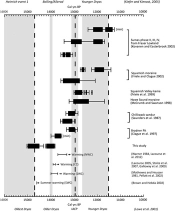
The late Pleistocene paleoclimate inferred by this study is consistent with other regional studies in coastal BC (Figs. 1 and 6). About 90 km south of the study area, Seymour Inlet and northern Vancouver Island had a climate characterized as cold and dry prior to 13.9–13.8 cal ka BP (Lacourse, Reference Lacourse2005; Stolze et al., Reference Stolze, Roe, Patterson and Monecke2007; Galloway et al., Reference Galloway, Doherty, Patterson and Roe2009), when a shift to a warmer climate is observed. These observations were based on palynological records recovered from lake cores. This chronology is very similar to that inferred by the sediments deposited at Foggy Cove, with a cold climate occurring between 15.1 and 14.3 cal ka BP and a retreat of ice occurring prior to 14.0–13.8 cal ka BP. Further north, at Haida Gwaii, and along the northwest coast of BC, the transition from a cool climate to a warmer, wetter climate occurred slightly later, from 13.7 to 13.3 cal ka BP (Warner, Reference Warner1984; Lacourse et al., Reference Lacourse, Delepine, Hoffman and Mathewes2012). On the southwest BC coast, including southern Vancouver Island and the Fraser Lowland, the transition from cool to warm occurs around 14.0 to 13.7 cal ka BP (Mathewes and Heusser, Reference Mathewes and Heusser1981; Pellatt et al., Reference Pellatt, Mathewes and Clague2002), with Brown and Hebda (Reference Brown and Hebda2002) suggesting that average summer temperatures began to increase as early as 14.9 cal ka BP. It should be noted that sea-surface temperature estimations off the west coast of Vancouver Island from Kienast and McKay (Reference Kienast and McKay2001) suggest cooling into the Oldest Dryas occurring ~15 cal ka BP and warming from the Bølling oscillation occurring by ~14 cal ka BP, which aligns well with the geochronology presented in this study.
Timing of late-glacial advances and retreats in coastal areas of British Columbia and Washington State. Solid bars and brackets indicate 1σ and 2σ of the calibrated calendar age from original radiocarbon ages, respectively. Cold-climate periods from Lowe et al. (Reference Lowe and Hoek2001) (IACP, inter-Allerød cold period) are shaded and labeled at the bottom of the figure, and climate periods identified for the northeast Pacific in Kiefer and Kienast (Reference Kiefer and Kienast2005) are bracketed by dashed lines and labeled at the top of the figure. All advances shown here follow initial retreat of the Cordilleran Ice Sheet from the study area. Where there are multiple age ranges per advance (for example, the range for this study), the older age indicates the limiting age of glacial readvance, and the younger age indicates the limiting age for final retreat. Climate data (the bottom four bars) show the range over which the climate began warming toward Holocene temperatures for each region: CC, central coast and northern Vancouver Island; NWC, the northwest coast; SWC, southwest coast (including the Fraser and Puget lowlands). Note also that each region and the area for each study are located in Figure 1.

Relation to other post-LGM advances in BC and possible mechanisms for ice advance
The timing of the late Pleistocene glacial readvance reported here, between 14.2 and 13.8 cal ka BP (Fig. 4, Table 1), may be an anomaly in BC as it appears to be out of phase (Fig. 6) with the pre–Younger Dryas advances documented in the Fraser Valley of southwest BC and the Puget Lowland of Washington State (e.g., Saunders et al., Reference Saunders, Clague and Roberts1987; Clague et al., Reference Clague, Mathewes, Guilbault, Hutchinson and Ricketts1997; McCrumb and Swanson, Reference McCrumb and Swanson1998; Friele et al., Reference Friele, Ekes and Hicken1999; Friele and Clague, Reference Friele and Clague2002; Kovanen and Easterbrook, Reference Kovanen and Easterbrook2002). Kovanen and Slaymaker (Reference Kovanen and Slaymaker2003) provide a minimum age for ice readvance in northwest Washington State that indicates ice readvanced prior to 13.1–12.8 cal ka BPFootnote 1 (11.1 14C yr BP, AA-27066), and more recently, Menounos et al. (Reference Menounos, Osborn, Clague and Luckman2009) refer to the Sumas advance occurring sometime after 14.5 cal ka BP, both overlapping with the findings of this study. The advance documented at Foggy Cove occurred shortly after the Oldest Dryas cold-climate period, defined as occurring before 14.7 cal ka BP (Lowe et al., Reference Lowe and Hoek2001; Fig. 6), which aligns well with regional paleoclimate reconstructions (discussed previously; Figs. 1 and 6) that indicate climate warming did not occur until after the end of the Older Dryas in the central and northern latitudes of BC. Alternatively, Kiefer and Kienast (Reference Kiefer and Kienast2005) establish the Heinrich event 1 climate period (17.4–14.7 cal ka BP) as characterized by oscillating warm and cold intervals, and this may have allowed for a short advance near the end of this time period (Fig. 6). Noteworthy is that the Calvert Island readvance is the northernmost of the lowland readvances shown in Figure 6, and the latitude-dependent lag in climatic warming observed in paleoclimatic reconstructions (e.g., climate remains colder longer at higher latitudes, as discussed in the previous section, shown in Fig. 6, and shown in Kiefer and Kienast [Reference Kiefer and Kienast2005]) may mean that there is a relation between the Foggy Cove readvance and others. However, perhaps the most conspicuous aspect of the data shown in Figure 6 is the lack of a clear link between late-glacial advances in BC and Washington State and established cold-climate periods, especially given that there is clear evidence for these cold-climate periods occurring in the region (e.g., Mathewes et al., Reference Mathewes, Heusser and Patterson1993; Gosse et al., Reference Gosse, Evenson, Klein, Lawn and Middleton1995; Benson et al., Reference Benson, Burdett, Lund, Kashgarian and Mensing1997; Kiefer and Kienast, Reference Kiefer and Kienast2005).
The oribatid mites found in unit 2 at the base of the Foggy Cove sequence were deposited between 15.1 and 14.3 cal ka BP, just prior to ice readvance. This evidence suggests a colder climate similar to that of the present day Arctic. These conditions were present at the study site after the local LGM, and it is reasonable to assume that the climate was warming prior to 15.1 cal ka BP, which initiated CIS retreat (e.g., Clague and James, Reference Clague and James2002). A warming climate may have been supplemented by a rising relative sea level causing increased marine glacier calving (cf. Clague et al., Reference Clague, Mathewes, Guilbault, Hutchinson and Ricketts1997); however, regional relative sea-level reconstructions extending to 15 ka BP suggest a sea level in the Calvert Island region that was stable and near present-day levels (McLaren et al., Reference McLaren, Fedje, Hay, Mackie, Walker, Shugar, Eamer, Lian and Neudorf2014; Shugar et al., Reference Shugar, Walker, Lian, Eamer, Neudorf, McLaren and Fedje2014). A regional reversal of this warming trend may have occurred at Calvert Island. If a cooling climate was a major contributing factor to the readvance, then the readvance may have been augmented by glaciers reforming in the prominent cirques on Mount Buxton in the center-east of the island, and interacting with stagnant ice (remnants of the CIS) in the lowlands, similar to the topographic effects described by Menounos et al. (Reference Menounos, Osborn, Clague and Luckman2009). It is also possible that the readvance on Calvert Island was not associated solely with climate cooling, but perhaps also as a result of an emerging seafloor that provided a deformable (slippery) substrate (e.g., Hicock and Fuller, Reference Hicock and Fuller1995; Hicock et al., Reference Hicock, Lian and Mathewes1999; Lian and Hicock, Reference Lian and Hicock2000). Muddy sediments found at the base of sections FC1 and FC3 provide support for this; however, the relative sea-level curve for the region indicates that sea level was higher at the time of readvance (as much as 6 m; McLaren et al., Reference McLaren, Fedje, Hay, Mackie, Walker, Shugar, Eamer, Lian and Neudorf2014), and there is no sedimentologic or geomorphic evidence for a rapid drop in sea level following the deposition of unit 2.
CONCLUSIONS
Records of late Pleistocene glacial readvances following the Cordilleran LGM are rare. This study presents a suite of lithostratigraphic and paleoecological information that together strongly suggests a late-glacial readvance on Calvert Island, BC, between 14.2 and 13.8 cal ka BP. The presence of oribatid mites in sediments near the base of the glacial advance sequence, which are only associated with today’s Arctic environments, suggests that the cause was a cold climate. A cold climate existing during this time interval agrees with other regional paleoclimatic reconstructions in coastal BC based on palynology from lake cores. However, the evidence for a readvance presented here occurs earlier than other documented readvances in the region. This lack of synchronicity indicates that local factors, such as the emergence of a deformable, slippery substrate that reduced shear stress at the base of a retreating glacier, may, in some cases, dominate the regional-scale climate drivers of CIS change during retreat. More research on the largely unexplored BC central coast is needed to refine the timing and ascertain the regional extent of this event.
ACKNOWLEDGMENTS
This research was supported financially and logistically by partners at the Hakai Institute and the Tula Foundation, notably Eric Peterson and Christina Munck. This project was also funded by a Natural Sciences and Engineering Research Council of Canada (NSERC) Postgraduate Scholarship and a Geological Society of America (GSA) Research Award to JBRE, a Mitacs Elevate Fellowship to DHS, and NSERC Discovery grants to IJW and OBL. V. Behan-Pelletier of Agriculture and Agri-Food Canada provided identification of mites. The authors are also grateful for reviews and suggestions from two anonymous reviewers, Associate Editor Thomas Lowell, and Senior Editor Nicholas Lancaster that significantly improved the paper. The authors recognize that this study took place on the traditional territory of the Heiltsuk and Wuikinuxv First Nations and are grateful for the opportunity.