


1. Introduction
It has long been recognized that ancient collisional orogens commonly consist of high-grade ‛axial’ zones surrounded by upper crust, often referred to as the infrastructure and superstructure, respectively (e.g. de Sitter & Zwart, Reference de Sitter and Zwart1960; Zwart, Reference Zwart1967; Murphy, Reference Murphy1987; Carreras & Capella, Reference Carreras and Capella1994; Culshaw, Beaumont & Jamieson, Reference Culshaw, Beaumont and Jamieson2006), or plateau and foreland in other concepts (e.g. Rey, Teyssier & Whitney Reference Rey, Teyssier and Whitney2010; Whitney et al. Reference Whitney, Roger, Teyssier, Rey and Respaut2015). Most recent models attempting to explain the tectonic juxtaposition of such contrasting crustal levels invoke displacement on low- to moderate-angle extensional detachments (e.g. Dewey, Reference Dewey1988; Costa & Rey, Reference Costa and Rey1995; Rey, Vanderhaeghe & Teyssier, Reference Rey, Vanderhaeghe and Teyssier2001; Platt et al. Reference Platt, Whitehouse, Kelley, Carter and Hollick2003; Rivers, Reference Rivers2012; Whitney et al. Reference Whitney, Teyssier, Rey and Buck2013; Platt, Behr & Cooper, Reference Platt, Behr and Cooper2014) and channel flow and extrusion of ductile lower crust between an underthrust continental indenter and an overlying upper-crustal rigid lid (e.g. Beaumont et al. Reference Beaumont, Jamieson, Nguyen and Lee2001; Jamieson & Beaumont, Reference Jamieson and Beaumont2013).
An important feature of orogenic infrastructure is the presence of high-pressure to ultrahigh-pressure (HP–UHP) rocks that commonly occur as small lenses or layers within relatively lower-pressure, mid-crustal host (see Dobrzhinetskaya & Faryad, Reference Dobrzhinetskaya, Faryad, Dobrzhinetskaya, Faryad, Wallis and Cuthbert2011; Liou et al. Reference Liou, Tsujimori, Yang, Zhang and Ernst2014 for overviews). The significance of such even volumetrically minor and sparse relics of HP–UHP rocks in the reconstruction of the tectonic evolution of collisional orogens is enormous as they may preserve the only record of an early subduction history of the orogen. In some cases, the HP–UHP assemblages tend to delineate the suprastructure–infrastructure boundary, raising the issue of how they were exhumed from the base of the thickened crust or even from mantle depths to shallow levels in these specific tectonic settings.
This paper examines the Podolsko complex, Bohemian Massif, as an example of a high-grade granite–migmatite dome that encloses relics of HP–UHP rocks and has been exhumed along the suprastructure–infrastructure boundary of the Variscan orogen (Fig. 1). New field observations and structural and anisotropy of magnetic susceptibility (AMS) data are presented, together with high-precision U–Pb zircon ages obtained using laser-ablation inductively coupled plasma mass spectrometry (LA-ICP-MS) to reveal the previously poorly known tectonic history of this metamorphic complex. Based on a combination of these datasets, we then argue for at least a three-stage exhumation history of the mixed (U)HP–mid-crustal assemblage, with late stages being facilitated firstly by lateral shortening and then by the supracrustal–infracrustal boundary as a major extensional detachment at around 340 Ma. This age has been particularly important for the evolution of the Variscan orogenic belt: it has been recognized in various parts of the orogen across central, western and southern Europe and is thought to represent a major changeover in its thermal–mechanical development. In this context, we finally add some new constraints and discuss the geodynamic significance of this c. 340 Ma tectonothermal event.
(a) Overview geological map showing basement outcrop areas and principal lithotectonic zones and sutures of the Variscan orogenic belt in Europe. Bohemian Massif is the easternmost inlier of the orogen. Compiled from Winchester (Reference Winchester2002), Asch (Reference Asch2003) and Martínez Catalán (Reference Martínez Catalán2011, Reference Martínez Catalán2012). (b) Greatly simplified geological map of the interior Bohemian Massif emphasizing orogenic suprastructure as represented by the Teplá–Barrandian unit and exhumed infrastructure (Moldanubian unit). The Podolsko complex is exposed near the suprastructure–infrastructure boundary. Based on geological map of the Czech Republic 1:500,000 published by the Czech Geological Survey, Prague. Principal lithotectonic elements and shear zones: CBPC – Central Bohemian Plutonic Complex; ČSZ – Červená shear zone; ESZ – Elbe shear zone; DSZ – Danube shear zone; KHU – Kutná Hora unit; KMZ – Kaplice mica schist zone; MT – Moldanubian thrust; NBSZ – North Bohemian shear zone; PFSZ – Pfahl shear zone; PLC – Pelhřimov complex; PMZ – Přibyslav mylonite zone; PPC – Popovice complex; SBG – South Bohemian granulites; VTSZ – Vodňany–Týn nad Vltavou shear zone; WBSZ – West Bohemian shear zone.

2. Plate-tectonic setting of the Podolsko complex
The Bohemian Massif of central Europe is the easternmost inlier of the once continuous but now largely dismembered Ouachita–Appalachian–Variscan orogenic belt that formed during the Devonian–Carboniferous convergence of Gondwana and Laurussia (Fig. 1; e.g. Pharaoh, Reference Pharaoh1999; Tait et al. Reference Tait, Schätz, Bachtadse, Soffel, Franke, Haak, Oncken and Tanner2000; Matte, Reference Matte2001; Winchester, Reference Winchester2002; Winchester et al. Reference Winchester, Pharaoh, Verniers, Ioane, Seghedi, Gee and Stephenson2006; Nance et al. Reference Nance, Gutierréz-Alonso, Keppie, Linnemann, Murphy, Quesada, Strachan and Woodcock2010; Kroner & Romer, Reference Kroner and Romer2013). A characteristic feature of the Variscan orogeny was the involvement of a number of microplates that were stuck in a broad collision zone as the two supercontinents converged, resulting in multiple subduction, accretion and collision events along the margins of the neighbouring microplates. As a result, the Bohemian Massif is a mosaic of several lithospheric units that have been variously correlated with broadly similar units across Western Europe to define three main zones of the orogen: Rhenohercynian, Saxothuringian and Moldanubian (Fig. 1).
One of the most important lithotectonic boundaries in the Variscan orogen delineates the outer margin of the Moldanubian Zone (Fig. 1) and separates generally low-grade, upper-crustal from high-grade, mid- to lower-crustal units representing orogenic suprastructure and infrastructure, respectively. The nature of this boundary varies along the strike of the orogen and the boundary records a complex polyphase history as proposed, for instance, by Skrzypek et al. (Reference Skrzypek, Schulmann, Tabaud, Edel, Schulmann, Martínez Catalán, Lardeaux, Janoušek and Oggiano2014) for the Vosges Mountains and by Ballévre et al. (Reference Ballévre, Bosse, Ducassou and Pitra2009) for the Armorican Massif in France (Fig. 1a). The same also applies to the Bohemian Massif: almost every possible sense of movement has been invoked to explain kinematic evolution of the SE boundary between the upper crust represented by the Teplá–Barrandian unit and the mid- to lower-crustal Moldanubian unit. The existing interpretations of their juxtaposition include: (1) dextral strike-slip shearing during early Carboniferous time (Matte et al. Reference Matte, Maluski, Rajlich and Franke1990); (2) sinistral strike-slip faulting at c. 320 Ma (Pitra, Burg & Guiraud, Reference Pitra, Burg and Guiraud1999); (3) top-to-the-SE thrusting of the Teplá–Barrandian over Moldanubian (Košler et al. Reference Košler, Rogers, Roddick and Bowes1995); (4) normal movements (Teplá–Barrandian down, Moldanubian up) (Pitra et al. Reference Pitra, Burg, Schulmann and Ledru1994; Zulauf, Reference Zulauf1994; Scheuvens & Zulauf Reference Scheuvens and Zulauf2000; Dörr & Zulauf, Reference Dörr and Zulauf2010); (5) polyphase evolution involving c. 380–365 Ma sinistral transtension, c. 354–346 Ma horizontal shortening and dextral transpression and c. 346–337 Ma normal movements (Žák et al. Reference Žák, Verner, Janoušek, Holub, Kachlík, Finger, Hajná, Tomek, Vondrovic, Trubač, Schulmann, Martínez Catalán, Lardeaux, Janoušek and Oggiano2014; Tomek, Žák & Chadima, Reference Tomek, Žák and Chadima2015).
The importance of the Teplá–Barrandian/Moldanubian boundary for understanding the evolution of the Variscan orogen is outstanding, with its plate-tectonic and palaeogeographic significance being vigorously debated. In one viewpoint, the boundary has been interpreted as a suture left behind after an oceanic domain subducted beneath the Teplá–Barrandian and which is now separating the outboard Cadomian terranes from the inboard Gondwana mainland (e.g. Franke, Reference Franke1999). In an opposing view, the Teplá–Barrandian and Moldanubian units represent different structural levels of a single microplate and therefore no suture is implied (e.g. Schulmann et al. Reference Schulmann, Lexa, Janoušek, Lardeaux and Edel2014).
Consequently, the palaeogeographic and tectonic significance of the Moldanubian unit, characterized by a complex and protracted Variscan tectonometamorphic history, remains uncertain (see Finger et al. Reference Finger, Gerdes, Janoušek, René and Riegler2007; Lardeaux et al. Reference Lardeaux, Schulmann, Faure, Janoušek, Lexa, Skrzypek, Edel, Štípská, Schulmann, Martínez Catalán, Lardeaux, Janoušek and Oggiano2014 for overviews). Large portions of this unit have pre-Variscan siliciclastic (meta-)sedimentary protoliths and are now represented by the low-pressure–high-temperature (LP–HT), commonly cordierite- and sillimanite-bearing and migmatitic biotite paragneisses, traditionally termed the Monotonous ‘series’ (e.g. Linner, Reference Linner1996; Petrakakis Reference Petrakakis1997; René, Reference René2006). The metaclastic rocks host numerous scattered kilometre-scale bodies of orthogneisses with Cambro-Ordovician protolith ages (Klomínský, Jarchovský & Rajpoot, Reference Klomínský, Jarchovský and Rajpoot2010), whereas other metasedimentary complexes enclose abundant lenses of marble, calc-silicate rocks, amphibolite and quartzite (the Varied ‘series’). The Moldanubian unit also contains multiple bodies of migmatitic orthogneisses and granulite facies rocks with intercalations of mantle peridotites, eclogites and pyroxenites, collectively referred to as ‘the Gföhl assemblage’ (Fig. 1b; e.g. Carswell & O'Brien, Reference Carswell and O'Brien1993; O'Brien & Carswell, Reference O'Brien and Carswell1993; Owen & Dostal, Reference Owen and Dostal1996; Cooke & O'Brien, Reference Cooke and O'Brien2001; Medaris et al. Reference Medaris, Wang, Jelínek, Mihaljevič and Jakeš2005; Medaris, Beard & Jelínek, Reference Medaris, Beard and Jelínek2006; Kotková, Reference Kotková2007). Since the seminal paper by Tollmann (Reference Tollmann1982), the large-scale structure of the Moldanubian unit has been interpreted as a result of nappe stacking where the highest-grade Gföhl assemblage was thrust to the SE as a coherent subhorizontal nappe over the underlying, lower-grade Varied and Monotonous ‘series’ (e.g. Matte et al. Reference Matte, Maluski, Rajlich and Franke1990; Franke, Reference Franke, Franke, Haak, Oncken and Tanner2000, Reference Franke, Gee and Stephenson2006). This assessment has been largely abandoned in a number of modern structural studies in favour of crustal-scale buckling, leading to vertical exhumation of high-pressure rocks followed by mid-crustal horizontal channel flow (e.g. Franěk, Schulmann & Lexa, Reference Franěk, Schulmann and Lexa2006; Franěk et al. Reference Franěk, Schulmann, Lexa, Tomek and Edel2011). Based on lithologic similarities, the Podolsko complex has also been assigned to the Gföhl assemblage and should even correspond to a root zone of the Gföhl nappe located along the Teplá–Barrandian/Moldanubian boundary. This point is returned to in the Discussion (Section 7).
3. Geology of the Podolsko complex and its mantling rocks
This paper concentrates on the NE portion of the Podolsko complex and its mantling rocks, both superbly exposed along the canyons of the Vltava and Lužnice rivers (Fig. 2). Other portions of the complex are poorly exposed or concealed beneath sedimentary cover. To the north, the Podolsko complex has been intruded along a sheeted contact by granitoids and melasyenitoids of the upper-crustal Central Bohemian Plutonic Complex with an estimated emplacement depth of c. 8–10 km (Žák et al. Reference Žák, Verner, Holub, Kabele, Chlupáčová and Halodová2012). The granitoids have been pervasively deformed in a magmatic to solid state along a major extensional detachment, the Červená shear zone, dipping moderately to the NNW (beneath the pluton). The detachment is one segment of several interconnected normal shear zones that delineate the Teplá–Barrandian upper crust and accommodated its downdrop and exhumation of the Moldanubian unit from c. 346 Ma to c. 337 Ma (main phase of ductile movements; Fig. 1b; Žák, Holub & Verner, Reference Žák, Holub and Verner2005; Dörr & Zulauf, Reference Dörr and Zulauf2010). The Podolsko complex is exposed in the footwall of the Červená shear zone and is therefore directly juxtaposed with the upper crust (Fig. 2).
Detailed geological map of the eastern part of the Podolsko complex and its mantling metasedimentary rocks. Compiled from Czech Geological Survey maps, scale 1:25,000, sheets 22–412 Záhoří, 22–121 Bechyně, 22–414 Protivín and 22–423 Týn nad Vltavou.

The complex itself is dominated by leucocratic migmatites, granitic gneisses and anatectic biotite granites, with a few minor bodies of variably retrogressed felsic kyanite-bearing and mafic orthopyroxene granulites and serpentinites (Zelenka, Reference Zelenka1927; Urban, Reference Urban1930; Röhlichová, Reference Röhlichová1962, Reference Röhlichová1963; Fediuková & Fediuk, Reference Fediuková and Fediuk1971). Fišera, Vrána & Kotrba (Reference Fišera, Vrána and Kotrba1982) were the first to interpret the granulites as recording a three-stage metamorphic history from a HP event through granulite facies overprint to extensive migmatization at lower pressures. These findings were corroborated by Kotková, Harley & Fišera (Reference Kotková, Harley and Fišera1997), who reported blocks of crustally derived garnetite that recorded UHP conditions with a pressure of c. 2.8 GPa at a temperature of c. 830°C (based on garnet–orthopyroxene geothermobarometry) and later granulite-facies overprint at a pressure of c. 0.8 GPa (see also Krenn & Finger, Reference Krenn and Finger2004; Finger & Krenn, Reference Finger and Krenn2007). The existing petrologic studies therefore indicate that at least some portions of the Podolsko complex were subducted to mantle depths and then decompressed to granulite-facies conditions.
Kotková, Dörr & Finger (Reference Kotková, Dörr and Finger1998) also obtained a poorly constrained 207Pb/206Pb age of 360±10 Ma on zircons and a total Pb age of 341±15 Ma on monazite from this sample. These ages broadly overlap with those reported by Finger & Krenn (Reference Finger and Krenn2007), who provided a chemical Th–U–Pb age of 341±7 Ma on monazite to date the (U)HP stage. The above studies and geological mapping also agreed that the complex experienced polyphase deformation and metamorphism during Late Devonian – early Carboniferous times.
The Podolsko complex has been intruded by variably sized bodies of ultrapotassic melagranites to melasyenites (c. 343–337 Ma durbachite suite) (Holub, Reference Holub1997; Holub, Cocherie & Rossi, Reference Holub, Cocherie and Rossi1997; Janoušek & Gerdes, Reference Janoušek and Gerdes2003) and numerous dykes of biotite and tourmaline granite, aplite and pegmatite (Fig. 2).
To the east, the Podolsko complex is in contact with stromatic biotite migmatites containing abundant up-to-kilometre-scale intercalations of quartzites, amphibolites, marbles and calc-silicate rocks, the whole assemblage being assigned to the Varied ‘series’ (Fig. 2). The contact between the Podolsko complex and metasedimentary rocks is not sharp-planar; instead, the Podolsko migmatites are interfingered with and form thin isolated lenses within the metasedimentary rocks. Vice versa, the metasedimentary rocks form abundant isolated screens within the leucocratic migmatites (Fig. 2).
To the south, both the Podolsko complex and the Varied unit have been overprinted by a broad c. NNW-dipping ductile normal shear zone (the Vodňany–Týn nad Vltavou shear zone) which truncates the complex, deflects the c. N–S-trending lithologic boundaries in the Varied ‘series’, and juxtaposes these units with pervasively sheared and variably retrogressed sillimanite–biotite paragneisses of the Monotonous ‘series’ in the footwall (Fig. 2). This shear zone was also termed the ‘Podolsko detachment’ by Lobkowicz, Štědrá & Schulmann (Reference Lobkowicz, Štědrá and Schulmann1996) and interpreted as recording extensional collapse in the interior of the Variscan orogen.
4. Structural analysis of the Podolsko complex and its mantling rocks
4.a. Mesoscopic fabrics
Across the Podolsko complex in a NW–SE direction, five structural domains have been identified on the basis of degree of anatexis, fabric orientation, fabric ellipsoid shape and kinematics (Figs 3–6).
Structural map of the eastern part of the Podolsko complex and its mantling metasedimentary rocks (background same as in Fig. 2). Stereonets (equal area, lower-hemisphere projections) show orientations of main structural elements.

Idealized structural cross-section along line A–A´ (location shown in Fig. 3) across the eastern part of the Podolsko complex and its mantling metasedimentary rocks.

Examples of macroscopic fabrics, deformational microstructures and kinematic indicators in the NE inner part of the Podolsko complex. See Figure 2 for location of photographs. (a) Deformed melagranite with S–C fabric indicating normal, SE-side-up kinematics within the Červená shear zone. WGS84 coordinates: 49.33956°N, 14.28462°E. (b) Asymmetric, NW-vergent recumbent folds affecting flat-lying foliation in leucocratic migmatite. WGS84 coordinates: 49.33456°N, 14.29254°E. (c) Flat-lying foliation and banding in leucocratic migmatite affected by extensional shearing to form asymmetric boudins and pinch-and-swell structures indicating normal, S-side-up kinematics. WGS84 coordinates: 49.313101°N, 14.31687°E. (d) Photomicrograph of faint flat-lying banding in leucocratic migmatite. Microfractures in garnet porphyroclasts are filled by chlorite aggregates. Foliation perpendicular section, plane-polarized light. WGS84 coordinates: 49.33314°N, 14.29755°E. (e) Steep compositional banding and foliation in stromatic biotite migmatite of the Varied ‘series’ overprinted by asymmetric recumbent folds. WGS84 coordinates: 49.24155°N, 14.36235°E. (f) Photomicrograph of steep foliation and banding in stromatic biotite migmatite. Foliation perpendicular section, plane-polarized light. WGS84 coordinates: 49.29816°N, 14.34271°E.

Examples of macroscopic fabrics, deformational microstructures, and kinematic indicators in the mantling metasedimentary rocks to the E and SE of the Podolsko complex. See Figure 2 for location of photographs. (a) Irregular folds in strongly constricted paragneiss of the Varied ‘series’, lineation-perpendicular section. WGS84 coordinates: 49.24502°N, 14.39000°E. (b) Constrictional microfabric in paragneiss, lineation-perpendicular section, plane-polarized light. WGS84 coordinates: 49.24603°N, 14.39530°E. (c) Biotite paragneiss from an area north of the main Vodňany–Týn nad Vltavou shear zone but pervasively overprinted by SE-side-up normal shearing. WGS84 coordinates: 49.25438°N, 14.41937°E. (d) Photomicrograph of migmatitized paragneiss of the Varied ‘series’ affected by extensional microshears. Mica fish indicate normal, SE-side-up kinematics. WGS84 coordinates: 49.24682°N, 14.40687°E. (e) Pervasive foliation and asymmetric quartz boudins in mylonitized paragneiss of the Monotonous ‘series’ within the Vodňany–Týn nad Vltavou normal shear zone. WGS84 coordinates: 49.21252°N, 14.44059°E. (f) Photomicrograph of biotite–sillimanite paragneiss of the Monotonous ‘series’ with extensional crenulation cleavage indicating normal SSE-side-up kinematics of the Vodňany–Týn nad Vltavou normal shear zone. Lineation parallel and foliation perpendicular section, plane-polarized light. WGS84 coordinates: 49.21570°N, 14.43671°E.

(1) The NW sheeted contact with the c. 346 Ma granodiorites is a major normal, SE-side-up shear zone (the Červená shear zone) that records down-temperature deformation from magmatic to solid state under the greenschist facies conditions (Žák et al. Reference Žák, Verner, Holub, Kabele, Chlupáčová and Halodová2012). The shear-zone solid-state foliation dips to the NW at a moderate angle and bears a downdip to dip-oblique, N-plunging stretching and mineral lineation (Figs 3, 4, 5a, b). The solid-state shear-zone fabric is seen in the granitoids, mantling paragneisses and leucocratic migmatites of the Podolsko complex (Fig. 3).
(2) A central domain occupied by the leucocratic migmatites is dominated by a syn-anatexis flat-lying, typically weakly developed compositional banding and biotite foliation (Figs 3, 4, 5b–d). Lineation is macroscopically not discernible on most outcrops; the macroscopic fabric ellipsoid is therefore oblate. The flat-lying foliation is superposed on an earlier c. NNW–SSE-trending relic steep foliation and the foliation poles therefore define a broad girdle about a gently c. NNW-plunging axis (Fig. 3). The flat-lying foliation has been affected by minor asymmetric s-shaped folds. The folds are gently inclined to recumbent with axial planes dipping to the c. SE (Fig. 5b). Although they occur domainally throughout the leucocratic migmatites, they become particularly abundant below the Červená shear zone. The fold asymmetry is consistent with the asymmetry of decimetre- to metre-scale boudins seen in places within the flat-lying foliation, both indicating normal, SE-side-up kinematics (Fig. 5c).
(3) In contrast, the easterly mantling migmatites exhibit c. N–S to c. NNE–SSW-trending steep to moderately dipping compositional banding and biotite foliation on most outcrops (Figs 3, 4, 5e, f). Again, lineation is not developed and the macroscopic fabric ellipsoid is oblate. Locally, the steep fabric is affected by minor recumbent folds with geometry similar to that observed in the leucocratic migmatites (Fig. 5e).
(4) Further to the east, the degree of anatexis decreases significantly and the syn-anatexis steep oblate fabric changes to solid-state plane-strain to strongly constrictional fabric in the outer mantling metasedimentary rocks. This fabric is defined by a strong subhorizontal c. NNW–SSE to c. N–S-trending mineral lineation and a N–S-trending foliation that dips at variable angles to the c. W and c. WSW, but is also frequently folded about a lineation-parallel axis into variably shaped minor folds (Figs 3, 4, 6a, b).
(5) To the SE, the above fabrics become pervasively overprinted by the Vodňany–Týn nad Vltavou shear zone, the fabric of which is similar to that of the northerly Červená shear zone. The shear zone foliation dips to the c. N to c. NNW at moderate angles and is associated with a dip-oblique NW-plunging mineral lineation, defined mostly by stretched sillimanite, biotite and chlorite aggregates (Figs 3, 4). Abundant macro- and microscopic kinematic indicators (asymmetric aggregates, boudins, σ-type porphyroclasts, mica fish, and anastomosing and oblique subfabrics) consistently indicate normal, SE-side-up kinematics (Fig. 6c–f).
4.b. Magmatic sheets cross-cutting the Podolsko complex
A number of magmatic sheets (dykes and sills) intruded the Podolsko complex and its mantling metasedimentary rocks. Their composition mostly includes melasyenite, biotite granite, aplite and muscovite–tourmaline granite (Fig. 2). On the map, the sheets have two distinct orientations. They strike c. N–S to c. NNE–SSW in the easterly mantling rocks, that is, roughly parallel to the strike of the compositional banding and metamorphic foliation, whereas they strike c. E–W to c. WSW–ENE in the Podolsko migmatites, anatectic granites and melasyenite pluton (Fig. 7). A statistical analysis of the latter sheets underlines their unimodal orientation distribution, as is apparent from the map, clustered about a mean trend of 82° (262°; Fig. 7).
Simplified map highlighting c. E–W magmatic sheets cross-cutting the Podolsko complex and the melasyenite Mehelník pluton. The sheets exhibit a remarkably uniform orientation (inset rose diagram). Sheets were extracted from geological map in Figure 2.

5. Anisotropy of magnetic susceptibility (AMS)
5.a. Methodology
The anisotropy of magnetic susceptibility (AMS; see Hrouda, Reference Hrouda1982; Rochette, Jackson & Aubourg, Reference Rochette, Jackson and Aubourg1992; Tarling & Hrouda, Reference Tarling and Hrouda1993; Borradaile & Henry, Reference Borradaile and Henry1997; Borradaile & Jackson, Reference Borradaile and Jackson2010 for reviews and principles of the method) was used to complement the structural data from the Podolsko complex and its mantling metasedimentary rocks. In particular, this method is useful to infer the possible principal stretching directions in migmatites which otherwise lack macroscopically discernible lineation (e.g. Ferré et al. Reference Ferré, Teyssier, Jackson, Hill and Rainey2002; Charles, Faure & Chen, Reference Charles, Faure and Chen2009; Schulmann et al. Reference Schulmann, Edel, Hasalová, Cosgrove, Ježek and Lexa2009 a; Kruckenberg et al. Reference Kruckenberg, Ferré, Teyssier, Vanderhaeghe, Whitney, Seaton and Skord2010, Reference Kruckenberg, Vanderhaeghe, Ferré, Teyssier and Whitney2011; Viegas, Archanjo & Vauchez, Reference Viegas, Archanjo and Vauchez2013). The samples were drilled in situ using a hand-held gasoline drill at 35 stations (19 in the Podolsko complex, 14 in metapelitic rocks of the Varied ‘series’ and 2 in the variably deformed granites). A total of 80 oriented cores were cut to 404 standard cylinder-shaped specimens 10 cm3 in volume. The AMS was measured at a low field of 200 Am–1 using a MFK1-A Kappabridge in the Laboratory of Rock Magnetism, Institute of Geology and Palaeontology, Charles University in Prague. A statistical analysis of the data was carried out using the ANISOFT 4.2 software (www.agico.com). The measured data are presented in Figure 8 and listed in full in the online Supplementary Material (Table S1, available at http://journals.cambridge.org/geo).
Maps showing orientations of magnetic foliations and lineations in the Podolsko complex and its mantling rocks. Stereonets (equal area, lower-hemisphere projections) summarize orientation of magnetic foliations and lineations.

Three parameters are used to characterize the magnetic fabric: (1) the mean susceptibility, k m = (k 1+k 2+k 3)/3, reflecting the magnetic mineral species and their proportion in the measured rock volume; (2) the degree of anisotropy, P = k 1/k 3, which expresses the eccentricity of the AMS ellipsoid; and (3) the shape parameter, T = 2ln(k 2/k 3)/ln(k 1/k 3) – 1, which describes the shape of the AMS ellipsoid; for –1 ≤ T < 0 the ellipsoid is prolate, for T = 0 it is triaxial and for 0 > T ≤ 1 it is oblate. The maximum, intermediate and minimum susceptibility axes are k 1, k 2 and k 3, respectively. The maximum principal susceptibility (k 1) represents magnetic lineation and the minimum principal susceptibility (k 3) represents a pole to magnetic foliation. The orientation of magnetic foliations and lineations is plotted in the lower hemisphere stereograms and as the station mean directions on the map (calculated according to Jelínek, Reference Jelínek1978).
5.b. Magnetic mineralogy
The mean (bulk) susceptibility of the vast majority (97%) of specimens is in the order of 10–5 and 10–4 (SI units are used throughout this paper). Only 12 specimens have higher susceptibilities in the order of 10–3 (online Supplementary Figure S1, available at http://journals.cambridge.org/geo). Eight of the high-susceptibility specimens are from a single locality (MB42); the other four are scattered among different sites. The prevailing low susceptibilities therefore indicate that paramagnetic minerals control the AMS (e.g. Hrouda & Kahan, Reference Hrouda and Kahan1991) at all but one station. At station MB42, the AMS signal is dominated by ferromagnetic sensu lato minerals.
In order to confirm the paramagnetic or ferromagnetic mineralogy and to determine the AMS carriers, variation of the susceptibility to temperature was measured on four representative coarsely powdered specimens using the CS-L Cryostat and CS-4 Furnace instruments (Hrouda, Reference Hrouda1994) in the Laboratory of Rock Magnetism, Institute of Geology and Palaeontology, Charles University in Prague. Specimens were heated from room temperature to c. 700°C and cooled down to c. 40°C at an approximate rate of 14°C/min in argon atmosphere to minimize mineral changes due to oxidation. The data were statistically treated and plotted using the Cureval 8 software (Agico, Inc.). The thermomagnetic curves are provided in online Supplementary Figure S2 (available at http://journals.cambridge.org/geo).
Several types of thermomagnetic curves were obtained during the experiments. (1) The representative low-susceptibility specimens (leucocratic migmatite MB5/1/2 and stromatic biotite migmatite MB35/1/4 with k m = 4.93×10⁻⁵ and 2.21×10⁻⁴, respectively) show a gradual hyperbolic decrease in the bulk susceptibility across the measured temperature range. Such hyperbolic heating curves, where the magnetic susceptibility is inversely proportional to the absolute temperature according to the Curie–Weiss law, indicate paramagnetic minerals (biotite) as the dominant AMS carriers. For the latter specimen, a small bump on the otherwise hyperbolic curve at a temperature of c. 580°C indicates a small admixture of magnetite. An additional increase on the cooling curves can be attributed to the growth of new magnetite as a result of decomposition and oxidation of Fe-bearing mineral phases with decreasing temperature. (2) The heating curve for an anomalous low-susceptibility but highly anisotropic and prolate specimen MB129/2/2 (k m = 7.28×10⁻⁴, P = 2.226, T = –0.211) shows a decrease in its initial part, a pronounced peak at a temperature of c. 320°C and then a near-hyperbolic decrease from that peak to the end of the temperature range. (3) The most complex heating curve was obtained for a high-susceptibility specimen MB42/3/1 (k m = 1.75×10⁻³), which shows a nearly constant susceptibility in its initial part and then two pronounced peaks at temperatures of c. 300°C and 520°C. The latter two cases therefore indicate complex magnetic mineralogies and mixed contributions of biotite, pyrhotite and magnetite.
5.c. Magnetic fabric parameters and orientation
Together with the fairly uniform mineralogy, the degree of anisotropy is comparable in all sampled units and the P parameter mostly does not exceed 1.2 (corresponding to 20% anisotropy), but is generally higher in the metasedimentary mantling rocks than in the Podolsko migmatites (online Supplementary Figure S1, available at http://journals.cambridge.org/geo). In both units, most of the AMS ellipsoids are oblate (78% in the Podolsko complex, 70% in the mantling rocks), with a slight tendency of an increasing degree of oblateness with an increasing degree of anisotropy. The exceptions to the above are the pyrhotite-bearing specimens from station MB42 (leucocratic migmatite), with P between 1.016 and 1.551, and specimens from station MB129 (stromatic biotite migmatite) with prolate AMS ellipsoids and P as high as 2.321.
At most stations, the measured orientations of the principal susceptibility axes are clustered, the site-mean directions are well defined and the mean magnetic foliation corresponds well to the metamorphic foliation and compositional banding. In Domain 1, magnetic foliations dip at low to moderate angles and have variable strikes, whereas in Domain 2 they strike roughly N–S and dip moderately in most cases (Fig. 8). In most of Domain 3, foliations dip steeply to moderately to the c. SW, but in its southern portion scatter along a c. N–S direction or become subparallel to the Vodňany–Týn nad Vltavou shear zone at the two southernmost stations (Fig. 8). The most striking feature of magnetic fabric in the Podolsko complex and its mantling rocks is, however, that magnetic lineations plunge shallowly to the c. N–NNW or to the c. S–SSE across the different structural domains regardless of lithology, degree of anatexis or location (Fig. 8). Magnetic lineations therefore exhibit a clustered orientation distribution on the stereonet, whereas magnetic foliation poles define a girdle about the mean magnetic lineation of 336°/04° (Fig. 8; calculated from all specimens using the method of Jelínek, Reference Jelínek1978, Reference Jelínek1981).
6. U–Pb zircon geochronology
6.a. Analytical methods
Five samples of c. 30–40 kg each were taken along an approximately N–S-oriented transect across the complex and at one locality off this transect (see Fig. 2 for sample locations). The sampling strategy was to cover the main rock types of the Podolsko complex and the mantling migmatites of the Varied ‘series’. Sample descriptions are given in Table 1. The samples were then crushed, the zircon grains separated using the Wilfley shaking table and heavy liquids in the laboratories of the Czech Geological Survey, Prague, and finally mounted in epoxy-filled blocks and polished for subsequent cathodoluminescence (CL) imaging.
Overview of U–Pb geochronology samples from the Podolsko complex (PC) and its metasedimentary mantling rocks (Varied ‘series’, VS).

The Nu AttoM high-resolution ICP-MS coupled to a 193 nm ArF excimer laser (Resonetics RESOlution M-50 LR) at Bergen University, Norway, was used to measure the Pb/U and Pb isotopic ratios in zircons over the course of three individual analytical sessions. The laser was fired at a repetition rate of 4 Hz and energy of 80 mJ with 19 microns spot size. Typical acquisition consisted of a 15 s measurement of blank, followed by a measurement of U and Pb signals from the ablated zircon for another 30 s. The data were acquired in time-resolved peak-jumping pulse-counting mode with one point measured per peak for masses 204Pb+Hg, 206Pb, 207Pb, 208Pb, 232Th, 235U and 238U. Due to a non-linear transition between the counting and attenuated (= analogue) acquisition modes of the ICP instruments, the raw data were pre-processed using a purpose-made Excel macro. As a result, the intensities of 238U are left unchanged if measured in a counting mode and recalculated from 235U intensities if the 238U was acquired in an attenuated mode. Data reduction was then carried out off-line using the Iolite data reduction package version 3.0 with VizualAge utility (Petrus & Kamber, Reference Petrus and Kamber2012). Full details of the data reduction methodology can be found in Paton et al. (Reference Paton, Woodhead, Hellstrom, Hergt, Greig and Maas2010). It included correction for gas blank, laser-induced elemental fractionation of Pb and U and instrument mass bias. For the data presented here, blank intensities and instrumental bias were interpolated using an automatic spline function while down-hole inter-element fractionation was corrected using an exponential function. No common Pb correction was applied to the data, but the low concentrations of common Pb were controlled by observing the 206Pb/204Pb ratio during measurements. Residual elemental fractionation and instrumental mass bias were corrected by normalization to the natural zircon reference material GJ-1 (Jackson et al. Reference Jackson, Pearson, Griffin and Belousova2004). Plešovice (Sláma et al. Reference Sláma, Košler, Condon, Crowley, Gerdes, Hanchar, Horstwood, Morris, Nasdala, Norberg, Schaltegger, Schoene, Tubrett and Whitehouse2008) and 91500 (Wiedenbeck et al. Reference Wiedenbeck, Alle, Corfu, Griffin, Meier, Oberli, von Quadt, Roddick and Speigel1995) zircon reference materials were periodically analysed during the measurement for quality control and the obtained mean values of 339.6±0.7(2σ) Ma and 1066±2(2σ) Ma are 1% accurate within the published reference values (337 Ma, Sláma et al. Reference Sláma, Košler, Condon, Crowley, Gerdes, Hanchar, Horstwood, Morris, Nasdala, Norberg, Schaltegger, Schoene, Tubrett and Whitehouse2008; 1065 Ma, Wiedenbeck et al. Reference Wiedenbeck, Alle, Corfu, Griffin, Meier, Oberli, von Quadt, Roddick and Speigel1995). The zircon U–Pb ages are presented as concordia diagrams and probability density plots, generated with the ISOPLOT program v. 3.50 (Ludwig, Reference Ludwig2008).
The measured U–Pb zircon data and cathodoluminescence (CL) images are presented in Figures 9–18 and listed in full in the online Supplementary Table S2 (available at http://journals.cambridge.org/geo).
Concordia diagrams and zircon age spectra (probability density plots) of the analysed samples from the Podolsko leucocratic migmatite (sample MB35), biotite migmatite of the Varied ‘series’ (sample MB126), deformed granite (sample MB144), anatectic granite (sample MB215) and retrogressed granulite (sample JZ965).

Representative cathodoluminescence images of zircon from sample MB35. The spots where laser-ablation analysis was performed are indicated together with the obtained 206Pb/238U ages. D – discordant analysis.

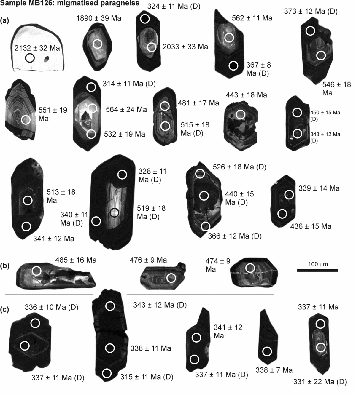
Representative cathodoluminescence images of zircon from sample MB126. The spots where laser-ablation analysis was performed are indicated together with the obtained 206Pb/238U ages. D – discordant analysis.
Representative cathodoluminescence images of zircon from sample MB144. The spots where laser-ablation analysis was performed are indicated together with the obtained 206Pb/238U ages. D – discordant analysis.

Representative cathodoluminescence images of zircon from sample MB215. The spots where laser-ablation analysis was performed are indicated together with the obtained 206Pb/238U ages. D – discordant analysis.

Representative cathodoluminescence images of zircon from sample JZ965. The spots where laser-ablation analysis was performed are indicated together with the obtained 206Pb/238U ages. D – denotes discordant analysis.

Concordia diagram for sample MB35 with a zircon weighted mean (concordia) Pb/U age.

Concordia diagrams for samples (a, b) MB126 and (c, d) MB144 with zircon weighted mean (concordia) Pb/U ages. The grey ellipses in (c) were not included in the calculation of the respective concordia age.

Concordia diagrams for sample MB215 with zircon weighted mean (concordia) Pb/U ages.

Concordia diagrams for sample JZ965 with (a) inherited and (b) metamorphic zircon weighted mean (concordia) Pb/U ages. The grey ellipses in (a) were not included in the calculation of the respective concordia age.

6.b. Results: zircon U–Pb data
6.b.1. Sample MB35 (leucocratic migmatite)
The sample contains mostly euhedral, long prismatic zircon grains with well-preserved faces (Fig. 10). Some grains are clear, but a large proportion of brown-coloured crystals point to pronounced metamictization and lead loss affecting the zircon. The inner textures of polished zircon grains together with U–Pb data reveal various degrees of isotopic disturbance and the presence of older cores enclosed within younger growth zones (Fig. 10). There are only a few zircon grains with ages older than c. 700 Ma. The majority of the data plot along the concordia over the range c. 630–340 Ma (Fig. 9), with the highest density at c. 480 Ma. The mean age of 482±1.7 Ma (Figs 9, 15), obtained from the euhedral prismatic grains with medium-CL intensity, probably records the event of magmatic zircon growth. The zircons with near-concordant or slightly discordant ages between c. 630 Ma and c. 482 Ma represent the inherited zircon component. They occur either as individual crystals (xenocrysts) or as partially resorbed cores overgrown by younger, c. 482 Ma old zircon (Fig. 10). Some of these inherited zircons were subjected to partial lead loss during the c. 482 Ma thermal event. The few discordant ages younger than 482 Ma show a trend towards c. 340 Ma but the absence of a clear age cluster suggests that this was only a lead loss event with limited or no growth of new zircon. The presence of a single zircon grain with oscillatory zoning, medium-CL intensity and concordant age of c. 340 Ma cannot be taken as evidence of new zircon formation. The c. 340 Ma event affected mostly the CL-dark, U-rich zircon grains (Fig. 10), which are known to be prone to lead loss during protracted thermal overprint. One of the metamict zircon grains shows a complete reset of U–Pb to c. 340 Ma (Fig. 10).
6.b.2. Sample MB126 (migmatitized paragneiss)
In terms of the obtained ages, this sample is similar to sample MB35. With the exception of two older zircon ages of c. 2.2 and c. 2.1 Ga, all the data plot within the range c. 610–340 Ma (Fig. 9). The visual inspection of zircon under binocular microscope and CL imaging revealed a higher degree of metamictization with a darker appearance of the investigated grains (Fig. 11). The U–Pb data show a higher abundance of c. 340 Ma ages with respect to c. 480 Ma mode in the probability density plot, when compared to sample MB35 (Fig. 9). There are fewer prismatic zircon grains with medium-CL intensity than in sample MB35 (Fig. 11b). However, their mean U–Pb age of 480.6±3.7 Ma (Fig. 16a) is identical within the analytical uncertainty to those in the sample MB35. We consider this age to represent the growth of magmatic zircon during the proto-source melting. Despite their higher discordance, the ages that cluster at c. 480 Ma represent the most abundant zircon component in the sample.
The higher abundance of c. 340 Ma ages suggests that the lead loss event had a larger impact on sample MB126 as compared to sample MB35 (Figs 9, 16b). On the other hand, this could merely be an effect of a higher content of U in the original zircon grains of MB126 and hence stronger metamictization of zircon lattice prior to c. 340 Ma. Besides a group of zircons with intermediate U–Pb ages between c. 480 and 340 Ma, there is also a distinct cluster of completely reset U-rich zircons (Fig. 11c) with a mean age of 338.5±2.2 Ma (Fig. 16b). None of the analysed zircons appear to have grown at c. 340 Ma.
6.b.3. Sample MB144 (deformed granite)
The lack of variation in appearance of zircon grains in sample MB144 corresponds to the still well-preserved magmatic texture of the granite (Fig. 12). Cathodoluminescence imaging revealed two distinct populations of zircon crystals: (1) euhedral prismatic zircons with simple pyramid terminations and dark-CL intensities, which make up a relatively small proportion of the bulk zircon content (Fig. 12a); and (2) stubby crystals with a complex pyramid termination, typical oscillatory zonation and medium-CL intensity, which account for most of the analysed zircon grains (Fig. 12b). The U–Pb data of the CL-dark population spread between c. 400–340 Ma, indicating that it represents an older, probably inherited zircon population with lead loss towards c. 340 Ma (Fig. 12). The youngest and completely reset zircons of this population make up a cluster with a U–Pb mean age of 340.5±4.5 Ma (Figs 9, 16c). The dating of zircon population (2) with typical magmatic textures provided a mean age of 339.8±1.0 Ma (Fig. 16d) which is identical, within analytical uncertainty, to the age of the completely reset inherited population. The data provide evidence of a magmatic event at c. 340 Ma, with the growth of new zircon as well as thermally induced lead loss of the older metamictized zircon xenocrysts. The limited number of inherited zircon grains and their strong isotopic disturbance preclude assessment of the nature and age of the sample MB144 precursor.
6.b.4. Sample MB215 (anatectic granite)
This sample contains a few zircons with ages of c. 2.6, 2.5, 2.0, 1.8, 0.9 and 0.7 Ma (Fig. 9). The grains with ages older than c. 500 Ma occur either as xenocrysts or as resorbed residues preserved as cores overgrown by younger zircon (Fig. 13a). The c. 480 Ma peak found in samples MB35 and MB126 is missing in sample MB215 (Fig. 9). This age is only represented by a few prismatic grains with a typical magmatic zonation and medium-CL intensities (Fig. 13c). The sample records a significant event at c. 340 Ma, as shown in the probability density plot. The careful examination of CL images (Fig. 13) and U–Pb data (Figs 9, 17) unveiled three different mechanisms that have probably led to the formation of zircon with c. 340 Ma age.
-
(1) A large proportion of zircon grains with dark-CL intensities and convoluted or featureless textures plots along concordia over the range c. 390–340 Ma and is most probably the product of the isotopic reset (= lead loss) of older zircon grains. They have a high U content (an average of 1370 ppm). The youngest concordant ages provide a mean age of 340±1.7 Ma (Figs 13c, 17b).
-
(2) Several zircon grains form euhedral, prismatic to stubby crystals with well-shaped faces and typical magmatic inner textures with oscillatory zonation of medium-CL intensities (Fig. 13d) and average U content of 529 ppm. All the U–Pb data obtained from these grains form a cluster with a mean age of 339.7±2.2 Ma (Fig. 17c).
-
(3) Some zircon grains show a unique texture where an inner part of elliptical shape, medium-CL intensity and sector zonation is enclosed by a CL-dark rim with faded relics of probably oscillatory zonation (Fig. 13e). The dark rims have high U concentrations (an average of 2144 ppm) and a variable content of Pb (5–7529 ppm, an average of 2614 ppm), corresponding to their supposed strong lattice damage (metamictization). Their U–Pb age data are strongly discordant with a few analyses between c. 375 and c. 337 Ma, documenting U–Pb reset towards the younger age. The inner parts show textures that are typical for zircons crystallized at a high metamorphic grade. They have normal contents of both U (average of 395 ppm) and Pb (average of 37 ppm) and the U–Pb dating provided a mean age of 340.8±1.4 Ma (Fig. 17d).
The three different types of zircon with ages of c. 340 Ma detected in the sample record a significant tectono-metamorphic event that probably included remelting of the source rock, facilitating crystallization of new magmatic zircon grains. The elevated temperatures also triggered U–Pb age reset (= lead loss) and new growth of zircon in U-rich metamict zircons. The appearance of the newly grown metamorphic zircons suggests that the rock might have undergone incipient granulite-facies metamorphism.
6.b.5. Sample JZ965 (felsic granulite)
Two types of zircon were identified in sample JZ965. The first type is represented by large prismatic grains, almost featureless and dark in CL (Fig. 14) and with a high content of U (average of 1664 ppm). The crystal faces are usually uneven with signs of recrystallization and resorption. Relics of CL-bright inner parts are preserved in some of these grains (Fig. 14). The U–Pb data fell within the range c. 420–340 Ma, suggesting they are older zircons with partial to complete lead loss at c. 340 Ma. The youngest cluster of ages provides a mean age of 339.1±1.5 Ma (Fig. 18a). One grain with a lower U content (375 ppm) and medium-CL intensity (first grain in Fig. 14) shows slightly discordant ages of c. 360 Ma in the outer part and c. 336 Ma age in the inner, probably fully annealed part. The second type represents the typical granulite-facies zircons with stubby and soccer-ball habits and sector zonation textures in CL (Fig. 14). This type commonly overgrows the older CL-dark zircon. It documents new zircon growth at granulite-facies conditions with a mean age of 339.6±1.2 Ma (Fig. 18b). The JZ965 sample contains on average much larger zircon grains (typically 300–800 μm) than the other studied samples, which suggests a different protolith.
7. Discussion
7.a. Chronology of events recorded in the Podolsko complex and its mantling rocks
Despite the pre-Variscan tectonic history of the Podolsko complex having been largely masked by the pervasive anatexis, our geochronologic data point to an Early Ordovician (c. 480 Ma) age of igneous protolith of the granulites and leucocratic migmatites and melting of the proto-source of the metapelitic migmatites of the Varied ‘series’ (Figs 9, 15, 16a). These findings are in agreement with what is well known from elsewhere in the Saxothuringian, Teplá–Barrandian and Moldanubian units and corroborate that the Cadomian basement in much of the Bohemian Massif underwent a widespread Cambro–Ordovician rifting and related LP–HT anatexis, plutonism and basin development (Fig. 19a; e.g. Kachlík & Patočka, Reference Kachlík and Patočka1998; Crowley et al. Reference Crowley, Floyd, Winchester, Franke and Holland2000; Dostal, Patočka & Pin, Reference Dostal, Patočka and Pin2001; Pin et al. Reference Pin, Kryza, Oberc-Dziedzic, Mazur, Turniak, Waldhausrová, Linnemann, Nance, Kraft and Zulauf2007; Žák, Kraft & Hajná, Reference Žák, Kraft and Hajná2013). The early Variscan (Middle–Late Devonian) history of the Podolsko complex is difficult to reconstruct due to the gap in the rock record. Nevertheless, the presence of HP–UHP garnetites (Kotková, Harley & Fišera, Reference Kotková, Harley and Fišera1997) and the newly discovered relic prograde garnet zoning in the mafic granulites (Faryad & Žák, Reference Faryad and Žák2016) suggest that at least some portions of the complex witnessed subduction to mantle depths and low-temperature eclogite-facies metamorphism prior to the extensive anatexis in the middle crust (Fig. 19a). Most of our new U–Pb ages reflect this latter event and indicate wholesale thermally induced isotopic resetting and new crystallization of zircons at c. 340–339 Ma (Figs 9, 15, 17, 18). The deformed granite (sample MB144), previously mapped as an ‘orthogneiss’, has virtually the same magmatic crystallization age of c. 340 Ma (Figs 12, 16c, d) and is interpreted here as a syntectonic intrusion. Field relations together with the high-precision U–Pb ages therefore indicate a rather narrow time span of the high-temperature anatexis and coeval ductile deformation of the Podolsko complex and its mantling rocks between c. 340 Ma and c. 338–337 Ma. The latter age bracket is provided by a discordant pluton and dykes cross-cutting the ductile fabric along the southern margin of the Central Bohemian Plutonic Complex (Žák, Holub & Verner, Reference Žák, Holub and Verner2005; Holub, Verner & Schmitz, Reference Holub, Verner and Schmitz2011).
7.b. Tectonic reinterpretation of the Podolsko complex
The structural data presented above suggest that the Podolsko complex and its metasedimentary mantling rocks underwent an early c. E–W horizontal shortening, followed by a switch in the principal strain axes to dominant vertical shortening (Figs 3, 19b). Importantly, the subhorizontal c. NNW–ESE magnetic lineations are homogeneously oriented across the entire area and are nearly perpendicular to the late c. E–W dykes (Figs 7, 8). Regardless of whether the lineations represent elongation or the zone axis of biotite aggregates (e.g. Henry, Reference Henry1997; Kruckenberg et al. Reference Kruckenberg, Ferré, Teyssier, Vanderhaeghe, Whitney, Seaton and Skord2010), they imply a single principal stretching direction during both deformations (Fig. 19b) which continued after cooling into the brittle regime. Virtually the same principal stretching direction was inferred for the deformed c. 346 Ma upper-crustal granitoids north of the Podolsko complex (Žák et al. Reference Žák, Verner, Holub, Kabele, Chlupáčová and Halodová2012). The roughly E–W gradient in the degree of anatexis (Fig. 2), together with the fabric patterns being smoothly continuous across these domains (Fig. 3), suggests a transition from melt-present to solid-state ductile flow in the direction away from the anatectic core of the complex. The presence or absence of melt during deformation most probably controlled the extensive reworking or preservation of early steep fabrics in the anatectic core and in solid-state mantling rocks, respectively, and therefore also variations in the strain symmetry from oblate to constrictional.
(a) Inferred, and certainly incomplete P–T–t–d path of the Podolsko complex and its metasedimentary mantling rocks showing its protracted tectonometamorphic history before and during the Variscan orogeny. The P–T estimations are from Faryad & Žák (Reference Faryad and Žák2016). (b) Interpretive block diagram showing a late-stage exhumation of the Podolsko complex at c. 340 Ma as an asymmetric granite–migmatite dome flanked by crustal-scale normal detachments. See text for discussion.

The almost identical U–Pb ages (c. 340–339 Ma), similar metamorphic grade during the widespread anatexis and an inferred single principal stretching direction indicate that the steep and flat-lying fabrics do not represent two separate deformation phases; rather, they formed in a kinematic continuum during exhumation and cooling of the whole complex (Fig. 19b). This interpretation is in agreement with recent numerical models of dome growth in metamorphic core complexes. For instance, Rey et al. (Reference Rey, Teyssier, Kruckenberg and Whitney2011) and Roger et al. (Reference Roger, Teyssier, Respaut, Rey, Jolivet, Whitney, Paquette and Brunel2015) documented a progressive transition from vertical fabric resulting from convergent viscous flow of partially molten crust at deeper levels to horizontal fabric resulting from extension in the upper crust. We therefore suggest that the Podolsko complex, with high-pressure rocks already included (mechanisms of their initial exhumation remain unknown), was upwelled within the ductile middle crust during lateral c. E–W shortening and c. NNW–SSE stretching to form an asymmetric domal structure with a hot migmatite–granite core and colder mantling sediments preserved on both sides (Fig. 19b). This process was perhaps driven by a combination of buoyancy, assuming that partially molten metapelitic and felsic rocks will be buoyant, and lateral tectonic forces, as evidenced by the steep foliation and horizontal magnetic lineations. Soon after, the whole dome collapsed vertically and its further exhumation was taken over by the more localized crustal-scale extensional detachments, the movements along which continued under the greenschist facies conditions. The detachments cut the dome at a high angle to the previous c. N–S structural grain but still accommodated the same c. NNW–SSE principal stretching (Figs 7, 8, 19b).
In summary, the observed widespread anatexis in the Podolsko complex is compatible with rapid exhumation of hot material to shallow levels, accommodated by fast extension strain rates in the upper crust (Rey, Teyssier & Whitney, Reference Rey, Teyssier and Whitney2009 a, b). It also seems likely that the far-field orogen-parallel stretching of the upper crust may have been a key process driving formation of the Podolsko dome (e.g. Brun & Van Den Driessche, Reference Brun and Van Den Driessche1994; Tirel, Brun & Burov, Reference Tirel, Brun, Burov, Whitney, Teyssier and Siddoway2004; Rey, Teyssier & Whitney, Reference Rey, Teyssier and Whitney2009 a, b; Roger et al. Reference Roger, Teyssier, Respaut, Rey, Jolivet, Whitney, Paquette and Brunel2015; Whitney et al. Reference Whitney, Roger, Teyssier, Rey and Respaut2015).
The interpretations developed above challenge the long-held view of the Podolsko complex as part of the extensive SE-directed Gföhl nappe rooted along the Teplá–Barrandian/Moldanubian boundary and transported over non-anatectic, lower-grade metasedimentary rocks (the Varied and Monotonous ‘series’) across much of the Moldanubian unit (e.g. Tollmann, Reference Tollmann1982; Franke, Reference Franke, Franke, Haak, Oncken and Tanner2000, Reference Franke, Gee and Stephenson2006). Instead, we suggest that it formed as an asymmetric granite–migmatite dome in the footwall of a major detachment (the Červená shear zone) separating the upper crust from the deep-crustal interior of the orogen. Another subparallel detachment (the Vodňany–Týn nad Vltavou shear zone) truncates the southern margin of the Podolsko complex and, as opposed to the previous poorly supported thrust-fault interpretation of Vrána (Reference Vrána1979, Reference Vrána1988), is also interpreted here to record normal kinematics and the same crustal extension (Figs 3, 4, 6c, d, 19b).
7.c. The significance and geodynamic causes of the Variscan c. 340 Ma event
The c. 340 Ma U–Pb ages detected in the Podolsko complex and its mantling rocks are almost identical within analytical uncertainties to a number of ages reported from some eclogites (e.g. Brueckner, Medaris & Bakun-Czubaróv, Reference Brueckner, Medaris and Bakun-Czubarów1991; Beard et al. Reference Beard, Medaris, Johnson, Brueckner and Mísař1992; Medaris et al. Reference Medaris, Beard, Johnson, Valley, Spicuzza, Jelínek and Mísař1995), high-pressure granulites (overviews in Kröner et al. Reference Kröner, O'Brien, Nemchin and Pidgeon2000; Janoušek & Holub, Reference Janoušek and Holub2007 and Kotková, Reference Kotková2007) and ultrapotassic plutons (e.g. Holub, Cocherie & Rossi, Reference Holub, Cocherie and Rossi1997; Janoušek & Holub, Reference Janoušek and Holub2007; Kotková, Schaltegger & Leichmann, Reference Kotková, Schaltegger and Leichmann2010; Kusiak et al. Reference Kusiak, Dunkley, Suzuki, Kachlík, Kedzior, Lekki and Opluštil2010) scattered within the Moldanubian unit and from a gabbro–peridotite intrusive complex at its NE margin (Ackerman, Pašava & Erban, Reference Ackerman, Pašava and Erban2013). On a continental scale, the c. 340 Ma ages have also been reported from other units along the Variscan orogenic belt in central and western Europe, including Saxothuringian and Eger Complex granulites (e.g. Kotková et al. Reference Kotková, Kröner, Todt and Fiala1995; Kröner et al. Reference Kröner, Jaeckel, Reischmann and Kroner1998; Romer & Rötzler, Reference Romer and Rötzler2001; Konopásek et al. Reference Konopásek, Pilátová, Košler and Sláma2014), mafic to felsic granitoid plutons in Odenwald (Altherr et al. Reference Altherr, Henes-Klaiber, Hegner, Satir and Langer1999), K–Mg plutons in the Vosges Mountains (Schaltegger et al. Reference Schaltegger, Schneider, Maurin and Corfu1996; Skrzypek, Štípská & Cocherie, Reference Skrzypek, Štípská and Cocherie2012; Tabaud et al. Reference Tabaud, Janoušek, Skrzypek, Schulmann, Rossi, Whitechurch, Guerrot and Paquette2014) and Variscan basement massifs of the Alps (Rubatto et al. Reference Rubatto, Ferrando, Compagnoni and Lombardo2010; von Raumer et al. Reference von Raumer, Bussy, Schaltegger, Schulz and Stampfli2013) and Corsica (Giacomini et al. Reference Giacomini, Dallai, Carminati, Tiepolo and Ghezzo2008). In particular, the widespread c. 340–335 Ma durbachite–vaugnerite suite was used as an argument for a short-lived but orogen-wide thermal pulse (von Raumer et al. Reference von Raumer, Finger, Veselá and Stampfli2014).
While most studies agree that the c. 340 Ma tectonothermal event must have represented a milestone in the evolution of the Variscan orogenic belt, significant controversies persist regarding its geodynamic causes. In the Bohemian Massif, the unresolved major issues include: (1) the palaeogeographic setting and the location and polarity of oceanic and continental subductions at that time (e.g. Franke, Reference Franke, Franke, Haak, Oncken and Tanner2000, Reference Franke, Gee and Stephenson2006; Medaris et al. Reference Medaris, Wang, Jelínek, Mihaljevič and Jakeš2005; Finger et al. Reference Finger, Gerdes, Janoušek, René and Riegler2007; Schulmann et al. Reference Schulmann, Edel, Hasalová, Cosgrove, Ježek and Lexa2009 b, Reference Schulmann, Lexa, Janoušek, Lardeaux and Edel2014; Babuška & Plomerová, Reference Babuška and Plomerová2013; Faryad & Kachlík, Reference Faryad and Kachlík2013; Zulauf et al. Reference Zulauf, Dörr, Fisher-Spurlock, Gerdes, Chatzaras and Xypolias2015); (2) the significance of the ubiquitous c. 340 Ma ages in granulites, that is, whether they represent maximum burial during crustal subduction or thickening or only a mid-crustal overprint on their retrograde path (e.g. Roberts & Finger, Reference Roberts and Finger1997; Kotková, Reference Kotková2007; Faryad, Nahodilová & Dolejš, Reference Faryad, Nahodilová and Dolejš2010); (3) the heat source and trigger for the c. 340–335 Ma magmatism and coeval deformation (e.g. Henk et al. Reference Henk, von Blanckenburg, Finger, Schaltegger, Zulauf, Franke, Haak, Oncken and Tanner2000), that is, whether elevated heat flow was caused by intracrustal radiogenic heating (Lexa et al. Reference Lexa, Schulmann, Janoušek, Štípská, Guy and Racek2011; Schulmann et al. Reference Schulmann, Lexa, Janoušek, Lardeaux and Edel2014), by input of hot mantle-derived melts after slab break-off or subcrustal mantle delamination (e.g. Steltenpohl et al. Reference Steltenpohl, Cymerman, Krogh and Kunk1993; Schaltegger, Reference Schaltegger1997; Willner et al. Reference Willner, Sebazungu, Gerya, Maresch and Krohe2002; Massonne, Reference Massonne2006; Faryad et al. Reference Faryad, Kachlík, Sláma and Hoinkes2015), or by rifting related to incision of the Palaeo-Tethys Ocean into the orogen (Franke et al. Reference Franke, Doublier, Klama, Potel and Wemmer2011; Franke, Reference Franke2014); and, last but not least, (4) evolution of surface palaeo-elevation, that is, whether this event was associated with the gravitational collapse of an orogenic plateau (Dörr & Zulauf, Reference Dörr and Zulauf2010, Reference Dörr and Zulauf2012) or the upper crust was only at low, near sea-level elevations (Franke, Reference Franke2012, Reference Franke2014).
Although it is beyond the scope of this paper to critically review details of all the models outlined above, our study of the Podolsko complex may add some new constraints on the Variscan c. 340 Ma event. Firstly, the extensive resetting of the U–Pb isotopic system in zircons from different units, including the retrogressed granulites within the migmatitic flat fabric (sample JZ965; Fig. 18), implies that the 340 Ma age post-dates the inferred high-pressure–low-temperature metamorphic peak and dates the mid-crustal, low-pressure–high-temperature overprint instead (Fig. 19a). Secondly, temperatures required to cause such extensive isotopic resetting (i.e. annealing of metamictized zircon lattice accompanied by more or less efficient lead loss) must have exceeded c. 600–650°C according to experimental and analytical studies (Mezger & Krogstad, Reference Mezger and Krogstad1997; Geisler & Tomaschek, Reference Geisler and Tomaschek2007; Schoene, Reference Schoene, Holland and Turejian2014). It would be difficult to reach such high temperatures at relatively shallow depths exclusively by intracrustal radiogenic heating (e.g. Gerdes, Wörner & Finger, Reference Gerdes, Wörner, Finger, Franke, Haak, Oncken and Tanner2000; Lexa et al. Reference Lexa, Schulmann, Janoušek, Štípská, Guy and Racek2011), an inference that favours a heat input from the underlying mantle during crustal thinning and collapse (this study) to cause the thermal anomaly (e.g. Henk et al. Reference Henk, von Blanckenburg, Finger, Schaltegger, Zulauf, Franke, Haak, Oncken and Tanner2000; Dörr & Zulauf, Reference Dörr and Zulauf2010; Faryad et al. Reference Faryad, Kachlík, Sláma and Hoinkes2015). Last but not least, the normal shearing accommodating downdrop of the Teplá–Barrandian upper crust and extensional unroofing of the Podolsko complex (Fig. 19) juxtaposed crustal levels corresponding to pressures of c. 0.2–0.3 GPa (c. 8–10 km) and 0.5 GPa (c. 18 km), respectively (Žák et al. Reference Žák, Verner, Holub, Kabele, Chlupáčová and Halodová2012; Faryad & Žák, Reference Faryad and Žák2016). The pressure difference therefore indicates a minimum throw along the Červená shear zone of c. 8–10 km, an estimate which is consistent with that proposed earlier by Zulauf et al. (Reference Zulauf, Bues, Dörr and Vejnar2002) and Dörr & Zulauf (Reference Dörr and Zulauf2010). The inferred minimum throw therefore provides a supporting argument for excess crustal thickness and significant palaeotopography in the interior of the Variscan orogenic belt during early Carboniferous time.
8. Conclusions
(1) The Podolsko complex was at least partly derived from Early Ordovician (c. 480 Ma) felsic igneous crust, the same age as inferred for melting the proto-source of the metapelitic migmatites of the Varied ‘series’. These ages are interpreted as recording the Cambro-Ordovician rifting widespread across the Cadomian basement of the Bohemian Massif.
(2) Relics of the HP–UHP rocks suggest that at least some portions of the complex witnessed an early Variscan subduction to mantle depths and low-temperature eclogite-facies metamorphism. This was followed by pervasive anatexis at mid-crustal levels at c. 340–339 Ma. Most of our new U–Pb ages reflect the latter event.
(3) The Podolsko complex developed as an asymmetric dome cored by hot migmatites–granites during lateral c. E–W shortening and c. NNW–SSE stretching, perhaps by a combination of buoyancy and lateral tectonic forces. The dome then collapsed vertically and its further exhumation was taken over by crustal-scale extensional detachments. One of these detachments separates the upper crust from the deep-crustal interior of the orogen. These inferences are at variance with a previous interpretation of the complex as part of the extensive SE-directed ‘Gföhl’ nappe.
(4) The c. 340 Ma U–Pb ages detected in the Podolsko complex and its mantling rocks have also been reported from other segments of the Variscan orogenic belt. It could be deduced from our data that the 340 Ma age post-dates the high-pressure metamorphic peak, the temperatures required to cause the observed isotopic resetting of zircon must have been relatively high (probably reflecting heat input from the underlying mantle) and, finally, that the extensional unroofing of the complex requires a minimum throw of c. 8–10 km to juxtapose the contrasting crustal levels. We use this as an additional argument for excess crustal thickness and significant early Carboniferous palaeotopography in the interior of the Variscan orogen.
Acknowledgements
We thank an anonymous reviewer for the detailed and constructive comments and Editor Mark Allen for his careful editorial handling. We also thank Shah Wali Faryad for discussions and for sharing his P–T estimations of the Podolsko complex granulites. František Veselovský is thanked for the mineral separations. This study was supported by the Grant Agency of Charles University through Grant No. 906513 (to Miroslav Burjak) and by Charles University project PRVOUK P44.
Supplementary material
To view supplementary material for this article, please visit http://dx.doi.org/10.1017/S0016756816000030.



