1. Introduction
Recent years have witnessed an ongoing effort to establish an Upper Ordovician chitinozoan biozonation in England and Wales, based on material from the type sections for the Caradoc and Ashgill series (Vandenbroucke, Rickards & Verniers, Reference Vandenbroucke, Rickards and Verniers2005; Vandenbroucke et al. Reference Vandenbroucke, Ancilletta, Fortey and Verniers2008). This has been particularly successful in the Cautley (type Ashgill) district in northern England and in establishing the relationship between the chitinozoan scheme and the British chronostratigraphical framework for the Late Ordovician. However, it has so far failed to provide a precise tie between the biozonal schemes for chitinozoans and graptolites, the latter being still the main biostratigraphical reference group (together with the conodonts) for the Ordovician System; this is an important gap, not least because of the current uncertainties regarding the graptolite biozonal age of chronostratigraphical boundaries in this time interval (cf. Rickards, Reference Rickards2002, Reference Rickards2004). In seeking to address this problem, this paper evaluates the chitinozoan biostratigraphy of key graptolite-bearing, Late Ordovician (Caradoc and Ashgill) successions in the Cardigan and Whitland areas of SW Wales (Fig. 1). This is viewed as an essential step towards providing an integrated chitinozoan and graptolite biozonation for the Late Ordovician that can be applied across the British Lower Palaeozoic, as the latter fossil group occurs only sporadically in the chitinozoan-bearing sections in northern England.
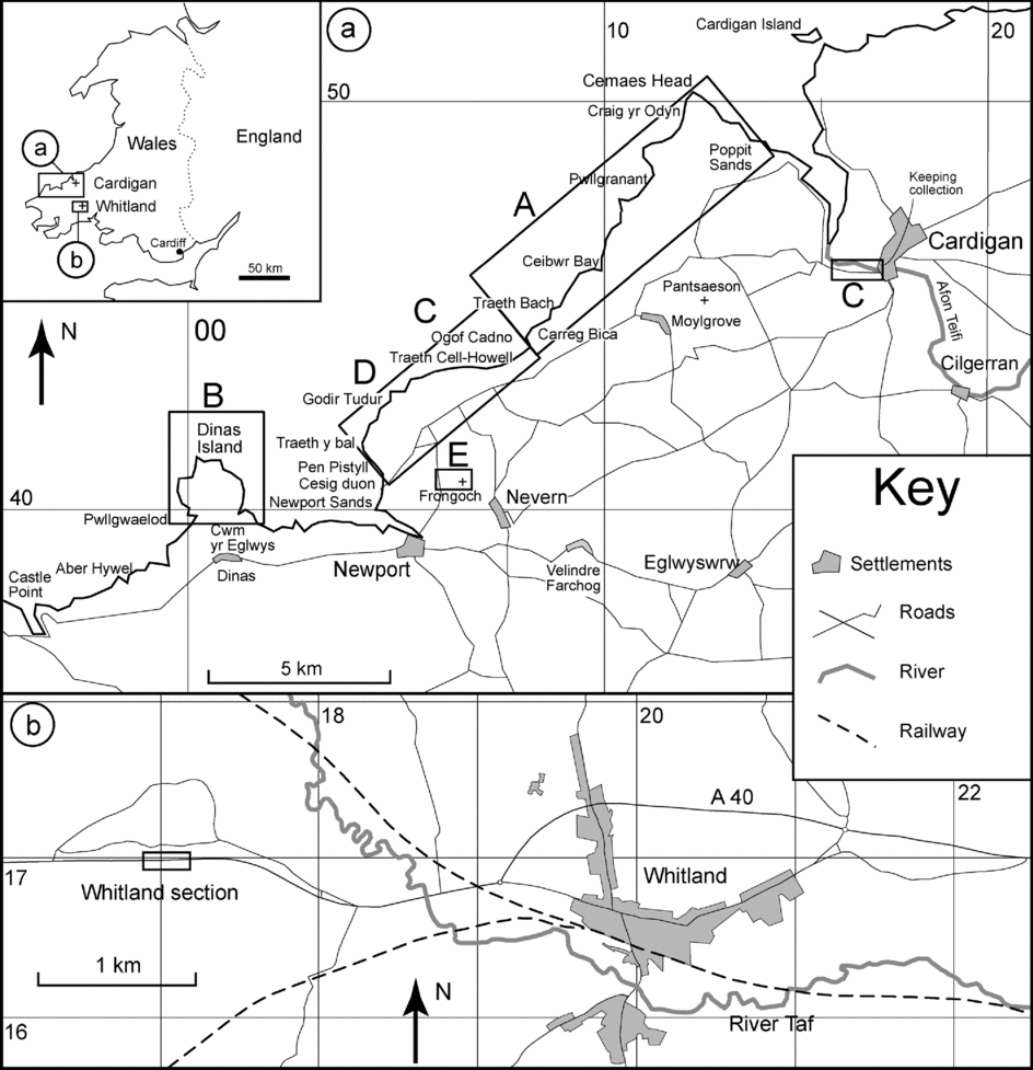
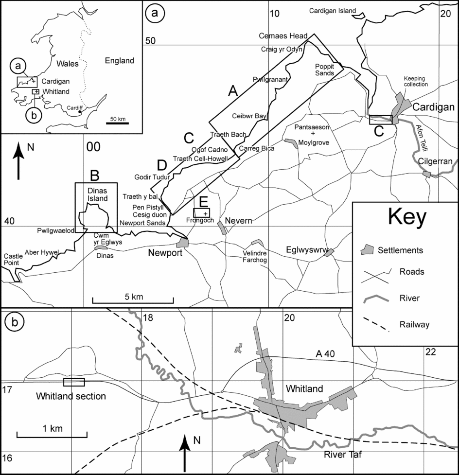
(a) Location of the principal sections (A to E) studied in the Cardigan area (after Williams et al. Reference Williams, Davies, Waters, Rushton and Wilby2003; UK National Grid SN) (b) Location of the Whitland section (UK National Grid SN).
2. Geological setting
This paper deals with two separate study areas: (1) the Cardigan area in SW Wales, between Fishguard in north Pembrokeshire and Cardigan in south Ceredigion, and (2) the Whitland–Meidrim area that lies to the east, in Carmarthenshire (Fig. 1).
2.a. The Cardigan area
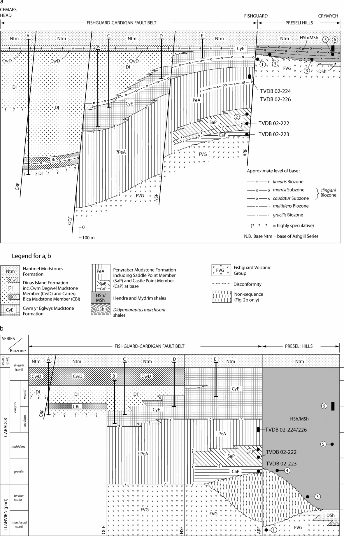
The following overview of the stratigraphy and facies architecture of the up to 1.3 km thick succession in the Cardigan district is based on the recent revision by Davies et al. (Reference Davies, Waters, Wilby, Williams and Wilson2003). The exposed formations display abrupt changes in facies and thickness across the ENE–WSW-trending faults of the Fishguard–Cardigan Fault Belt (Fig. 2), which played an important role during both the accumulation and deformation of the sediments. The Caradoc strata are spectacularly exposed in the coastal cliffs in the area, in contrast to smaller and poorly exposed inland outcrops. Several of the localities described are only accessible by boat. The succession contrasts markedly with coeval sequences developed in the Preseli Hills to the south and elsewhere in South Wales (see below).
(a) Lithostratigraphy and facies architecture of the Caradoc succession in the Cardigan area (from Williams et al. Reference Williams, Davies, Waters, Rushton and Wilby2003). The position of the sections studied (A to E) and several sample localities (TVDB) referred to in the text are indicated. Locality 1 yields murchisoni Biozone graptolites (Lowman & Bloxam, Reference Lowman and Bloxam1981). The other localities 2–6 are explained in the text. (b) The chronostratigraphical version of (a). Abbreviations: ARF – Aber Richard Fault; CBF – Ceibwr Bay Fault; NSF – Newport Sands Fault; OCF – Ogof Cadno Fault.
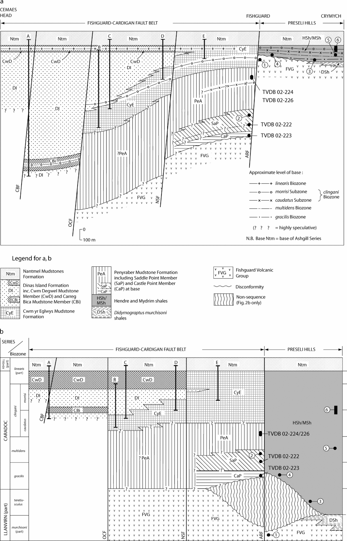
In the Cardigan area, the Penyraber Mudstone Formation is the lowest sedimentary Caradoc formation and rests unconformably on the Llanvirn Fishguard Volcanic Group. It consists mainly of grey mudstones, with the exception of the coarser sediments of the basal Castle Point Member. In the overlying Saddle Point Member, allochthonous rafts of various volcanic and sedimentary lithologies can be recognized in the mudstones. These two members are succeeded by turbiditic, silty mudstone with occasional burrows, deposited in a weakly oxic setting. The overlying Cwm-yr-Eglwys Mudstone Formation comprises turbiditic mudstones, associated thin beds of siltstone and sandstone, and laminated hemipelagites; the latter are indicative of deposition beneath anoxic bottom waters. The Cwm-yr-Eglwys Mudstone Formation forms the top of the Caradoc succession south of the Newport Sands Fault, but passes laterally into the Dinas Island Formation north of the fault. The latter is a sandstone-dominated turbidite sequence, spectacularly exposed in the cliffs and incorporating several, often local, mudstone units of which only two have been given formal ‘member’ status. The Cwm Degwel Mudstone Member at the top of the formation is the only one to have been correlated between the major cliff sections. Anoxic bottom water conditions persisted, as can be concluded from the presence of laminated hemipelagites throughout the formation. Both the Cwm Degwel Member to the north of the Newport Sands Fault, and the Cwm-yr-Eglwys Mudstone to the south are sharply overlain by oxic, strongly burrow-mottled facies characteristic of the widely recognized Nantmel Mudstones Formation. Throughout central Wales, the abrupt change from anoxic to oxic facies at the base of the latter formation has been taken as a proxy for the Caradoc/Ashgill boundary (Davies et al. Reference Davies, Fletcher, Waters, Wilson, Woodhall and Zalasiewicz1997, Reference Davies, Waters, Wilby, Williams and Wilson2003; Fortey et al. Reference Fortey, Harper, Ingham, Owen, Parkes, Rushton and Woodcock2000).
In the Preseli Hills, south of the Fishguard–Cardigan Fault Belt, a late Llanvirn to Caradoc succession of black, graptolitic mudstones is equivalent to the Hendre Shales and Mydrim Shales of South Wales and is overlain by the oxic Nantmel Mudstones. The contrasting succession straddling the Fishguard–Cardigan Fault Belt formed within a fault-controlled trough in which, initially, there was much non-graptolitic oxic marine deposition (Penyraber Mudstone Formation) and which subsequently confined the sand-prone facies of the Dinas Island Formation (Davies et al. Reference Davies, Waters, Wilby, Williams and Wilson2003, p. 9, Fig. 4), whereas, to the south of the fault belt, black graptolitic mudstone deposition was allowed to proceed uninterrupted throughout the Late Ordovician. However, these abrupt changes in facies and sequence may additionally (or instead) record juxtaposing of once widely separated facies belts by strike-slip faulting (Williams et al. Reference Williams, Davies, Waters, Rushton and Wilby2003).
2.b. Whitland and Meidrim
Fortey et al. (Reference Fortey, Harper, Ingham, Owen, Parkes, Rushton and Woodcock2000, p. 16) describe the central south Wales area as probably having ‘the most complete Ordovician succession of any part of Britain’, hence two stratigraphically consecutive sections through the same lithostratigraphical succession were selected for this study: the Meidrim village section and Whitland road cutting. The Meidrim (formerly Mydrim) area was selected to study the Nemagraptus gracilis Biozone–Diplograptus foliaceus Biozone transition (Bettley, Fortey & Siveter, Reference Bettley, Fortey and Siveter2001), and the Whitland section because of its Caradoc–Ashgill boundary succession and its recently revised graptolite biostratigraphy (Zalasiewicz, Rushton & Owen, Reference Zalasiewicz, Rushton and Owen1995). The lithological succession of these two areas comprises, in ascending order: the Hendre Shales (250 m), Mydrim Limestone (40 m), Mydrim Shales (150 m) and Sholeshook Limestone (70+ m) formations. Due to disappointing results in the Meidrim area (none of the nine dissolved samples from the upper part of the Hendre Shales to the lower part of the Mydrim Shales yielded identifiable species), no further attempt has been made to integrate the section in this study (see T. R. A. Vandenbroucke, unpub. Ph.D. thesis, Ghent Univ. 2005).
The Whitland section [SN 1697 1699–1713 1698] is a recent road cutting along the A40, 3 km west of Whitland. The bulk of the strata exposed are laminated grey graptolitic mudstones and silty mudstones of the Mydrim Shales, formerly called the Dicranograptus Shales (Zalasiewicz, Rushton & Owen, Reference Zalasiewicz, Rushton and Owen1995). The mudstones are thought to have been deposited under dysaerobic bottom conditions. Towards the upper part, they become paler, and less distinctly laminated; thin beds of limestone appear in the uppermost part forming a transition into the overlying Sholeshook Limestone, which is sparsely shelly.
In attempting to calibrate UK chitinozoan and graptolite biozonal schemes, this paper will also address outstanding biostratigraphical issues in the South Wales Late Ordovician by seeking to:
(1) gain a better insight into the relationships between chitinozoans and graptolites in the Welsh basin during the Caradoc–Ashgill;
(2) determine the age of the oldest Caradoc strata disconformably overlying the Fishguard Volcanic Group in the Cardigan district;
(3) determine the age of the anoxic to oxic transition at the base of the Nantmel Mudstones Formation, currently taken to equate with the base of the Ashgill Series;
(4) evaluate the stratigraphical level attributed to the ‘Normalograptus proliferation interval’ in the Whitland section;
(5) enable more precise correlation between the Upper Ordovician rocks of SW Wales and the Ordovician sequences of northern England.
3. Graptolite biostratigraphy
A detailed assessment of the graptolite biostratigraphy of the Cardigan area by Williams et al. (Reference Williams, Davies, Waters, Rushton and Wilby2003) produced the following conclusions.
(1) The Castle Point Member post-dates mudstones near the top of the Fishguard Volcanic Group, which contain Didymograptus murchisoni Biozone graptolites.
(2) A black mudstone raft [SM 990 385] (Fig. 2, locality 2) in the Saddle Point Member gives a maximum age referable to the Diplograptus multidens Biozone.
(3) The Cwm-Yr-Eglwys Mudstone Formation south of the Newport Sands Fault includes both the Dicranograptus clingani and Pleurograptus linearis biozones of the Caradoc. P. linearis itself is not known from Wales, but Climacograptus tubuliferus is taken as diagnostic of the P. linearis Biozone; this represents the first definite record of the biozone in Wales.
(4) North of the Newport Sands Fault, the Cwm-Yr-Eglwys Mudstone Formation is partly replaced by the Dinas Island Formation and confined to the D. clingani Biozone, more precisely the Ensigraptus caudatus Subzone at Dinas Island, but also including the higher Dicellograptus morrisi Subzone at Newport Sands. To the north of the Ogof Cadno Fault, the base of the Dinas Island Formation lies within the E. caudatus Subzone as the caudatus–morrisi boundary occurs in the middle part of the Carreg Bica Mudstone Member; south of the fault, the base of the Dinas Island Formation lies within the D. morrisi Subzone. The presence of probable C. tubuliferus near the top of the Dinas Island Formation (Cwm Degwel Mudstone) suggests that this part of the formation may range into the P. linearis Biozone.
(5) South of the Fishguard–Cardigan Fault Belt, the black mudstone succession of the Preseli Hills has yielded graptolites from several localities, indicative of the Hustedograptus teretiusculus Biozone at Pen-cnwc Bach [SM 124 375] (Fig. 2, locality 3), the Nemagraptus gracilis Biozone at Felindre Farchog [SM 0975 3870] (Fig. 2, locality 4), and the D. multidens and D. clingani biozones at Crymych [SM 183 388] (Fig. 2, localities 5 and 6).
Zalasiewicz, Rushton & Owen (Reference Zalasiewicz, Rushton and Owen1995, Fig. 3) recognized three assemblages of graptolites in the measured section at Whitland, listed in ascending order:
(1) Dicranograptus clingani Biozone (lower part), between 12.5 and 27 m above the base of the section;
(2) miserablis–morrisi interval, between 27 and 39 m above the base of the section;
(3) Normalograptus proliferation interval, between 39 and 57 m above the base of the section.
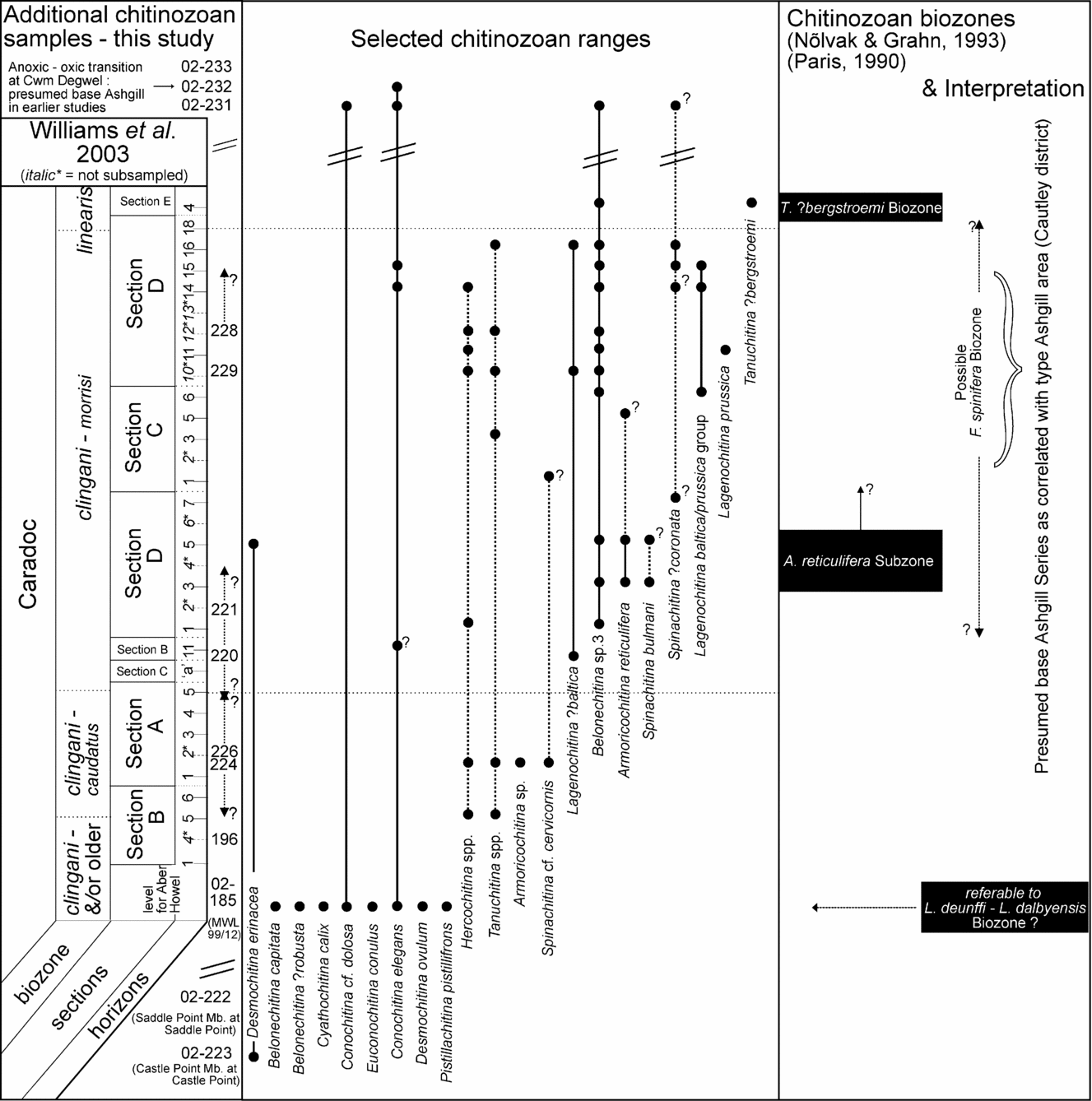
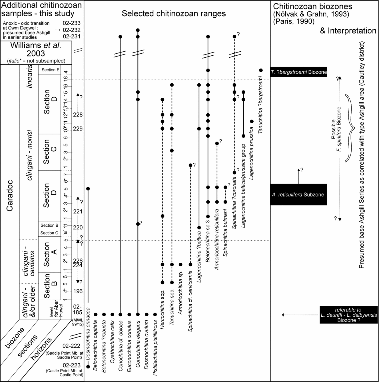
Composite range chart of chitinozoan species in the Cardigan area; the reconstruction of the succession is based on Williams et al. (Reference Williams, Davies, Waters, Rushton and Wilby2003, p. 557) and is not to scale. The TVDB sample numbers corresponding to the sub-sampled levels from Williams et al. (Reference Williams, Davies, Waters, Rushton and Wilby2003) are shown in Figures 4, 5 and in the Appendix. The precise stratigraphical position of some of the additional samples collected on the Ludlow Research Group (LRG) field trip is uncertain (modified after Williams et al. Reference Williams, Davies, Waters, Rushton and Wilby2003).
The Dicranograptus clingani levels (the lower part and the morrisi interval) can easily be correlated with other levels with a comparable fauna (with Cardigan, but also with, for example, Hartfell Score, Scotland), but the upper levels of the Whitland section are more problematic. The incoming of Normalograptus forms was tentatively correlated with the base of the Pleurograptus linearis Biozone by Zalasiewicz, Rushton & Owen (Reference Zalasiewicz, Rushton and Owen1995). However, in Whitland the typical forms characterizing the P. linearis Biozone, such as leptograptids or pleurograptids, are absent, while in other upper Caradoc sections, the aforementioned ‘Normalograptus proliferation’ assemblages have not been recovered. Williams et al. (Reference Williams, Davies, Waters, Rushton and Wilby2003) explain the late Caradoc faunal contrast between Cardigan and Whitland in terms of graptolite ecology: up to the mid-clingani level, an offshore, open marine, ‘graptolite-friendly’ biotope existed in both areas, giving rise to highly diverse graptolite faunas. In the late Caradoc, cooling and falling global sea-levels were responsible for the shallowing of the shelf in Whitland, establishing an inshore, graptolite biotope of ‘cratonic invaders’ of the low diversity, Normalograptus proliferation fauna. In Cardigan, however, the offshore, open marine ‘graptolite-friendly’ biotope persisted due to the local development of a deep marine trough (Davies et al. Reference Davies, Waters, Wilby, Williams and Wilson2003).
In addition to graptolite fauna, a shelly fauna was obtained from the lower levels of the Sholeshook Limestone between 58.5 and 65 m above the base of the section. It is characteristic of the late Pusgillian and early Cautleyan in Wales and northern England (Price, Reference Price1984; Zalasiewicz, Rushton & Owen, Reference Zalasiewicz, Rushton and Owen1995). Price published several papers on the trilobite fauna and age of the Sholeshook Limestone, dating the base of the formation to the early Cautleyan and its youngest levels to the early Rawtheyan (Price, Reference Price1973, Reference Price1977, Reference Price1980, Reference Price1984). His conclusions were drawn prior to the finds of Zalasiewicz, Rushton & Owen (Reference Zalasiewicz, Rushton and Owen1995), and there is now evidence from the shelly fauna that the base of the Sholeshook Limestone in Whitland might be a little older than in other localities. Fortey et al. (Reference Fortey, Harper, Ingham, Owen, Parkes, Rushton and Woodcock2000) considered the Sholeshook Limestone as late Pusgillian–largely Cautleyan in age, and the topmost strata are dated to the early Rawtheyan. Zalasiewicz, Rushton & Owen (Reference Zalasiewicz, Rushton and Owen1995) re-examined graptolites from the Sholeshook Limestone, originally reported by Strahan et al. (Reference Strahan, Cantrill, Dixon, Thomas and Jones1914) and assigned to their local Orthograptus truncatus Biozone; these graptolites are better referable to Orthograptus abbreviatus, indicative of the Dicellograptus anceps Biozone (that is, Rawtheyan).
4. Sampling for chitinozoans
Collections made by Williams et al. (Reference Williams, Davies, Waters, Rushton and Wilby2003) are stored at the British Geological Survey in Keyworth, Nottingham, and have been resampled as part of this study. This permits a precise correlation between the graptolites and chitinozoans recovered. The sub-sampled levels are from the Williams et al. (Reference Williams, Davies, Waters, Rushton and Wilby2003) sections A to E, which are indicated on our Figures 1 to 3 and their Figures 3 to 7. The Williams et al. (Reference Williams, Davies, Waters, Rushton and Wilby2003) sample numbers and the corresponding TVDB chitinozoan sample numbers are shown in Figures 4 and 5 and in the Appendix. A sub-sample from the graptolite sample at Aber Howel was also obtained (Fig. 2, locality 2, TVDB 02-185). Samples from the Whitland section were obtained during 2002. Close correlation with the graptolite levels was possible as the markings (denoting metres above the base of the section) for the graptolite study by Zalasiewicz, Rushton & Owen (Reference Zalasiewicz, Rushton and Owen1995) were still visible on the rock face. Additional samples from the Cardigan area, collected during a Ludlow Research Group meeting in 2003, have been collected from:
(1) Castle Point (TVDB 02-223) and Saddle Point (TVDB 02-222) and their eponymous lithological members (see location on Fig. 2a);
(2) Parrog [SN 049 397], along the coast between Newport and Dinas Island: oxic, mottled Penyraber Mudstone Formation (TVDB 02-224) with phosphatic nodules (TVDB 02-226);
(3) Section D, Newport Sands, D. clingani Biozone (TVDB 02-229), locality 10 of Williams et al. (Reference Williams, Davies, Waters, Rushton and Wilby2003);
(4) Section E, Frongoch quarry, D. clingani Biozone (TVDB 02-228), close to locality 2 of Williams et al. (Reference Williams, Davies, Waters, Rushton and Wilby2003);
(5) Cwm Degwel [SN 1635 4540], at the transition from the anoxic Dinas Island Formation lithology into the grey, mottled Nantmel Mudstone Formation, at the assumed base of the Ashgill; TVDB 02-231, 02-232 and 02-233 respectively at about 1 m below, at the facies transition, and 1 m above it;
(6) Preseli Hills, Crymych [SM 183 338], D. clingani Biozone (Fig. 2, locality 6; TVDB 02-220, 02-221).
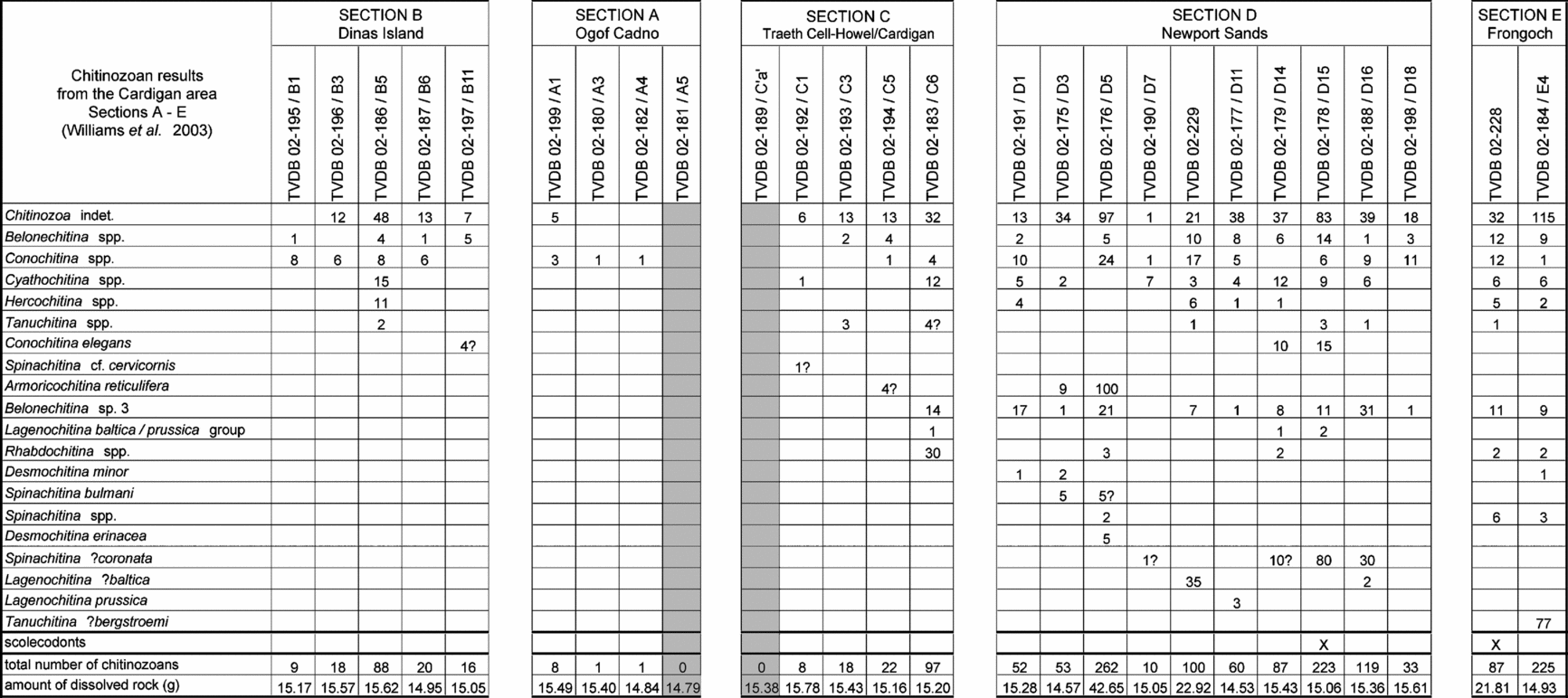
Numerical results from sections A to E as mentioned in Williams et al. (Reference Williams, Davies, Waters, Rushton and Wilby2003). The residue of all samples has been completely picked and investigated.
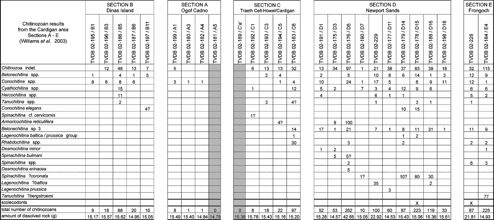
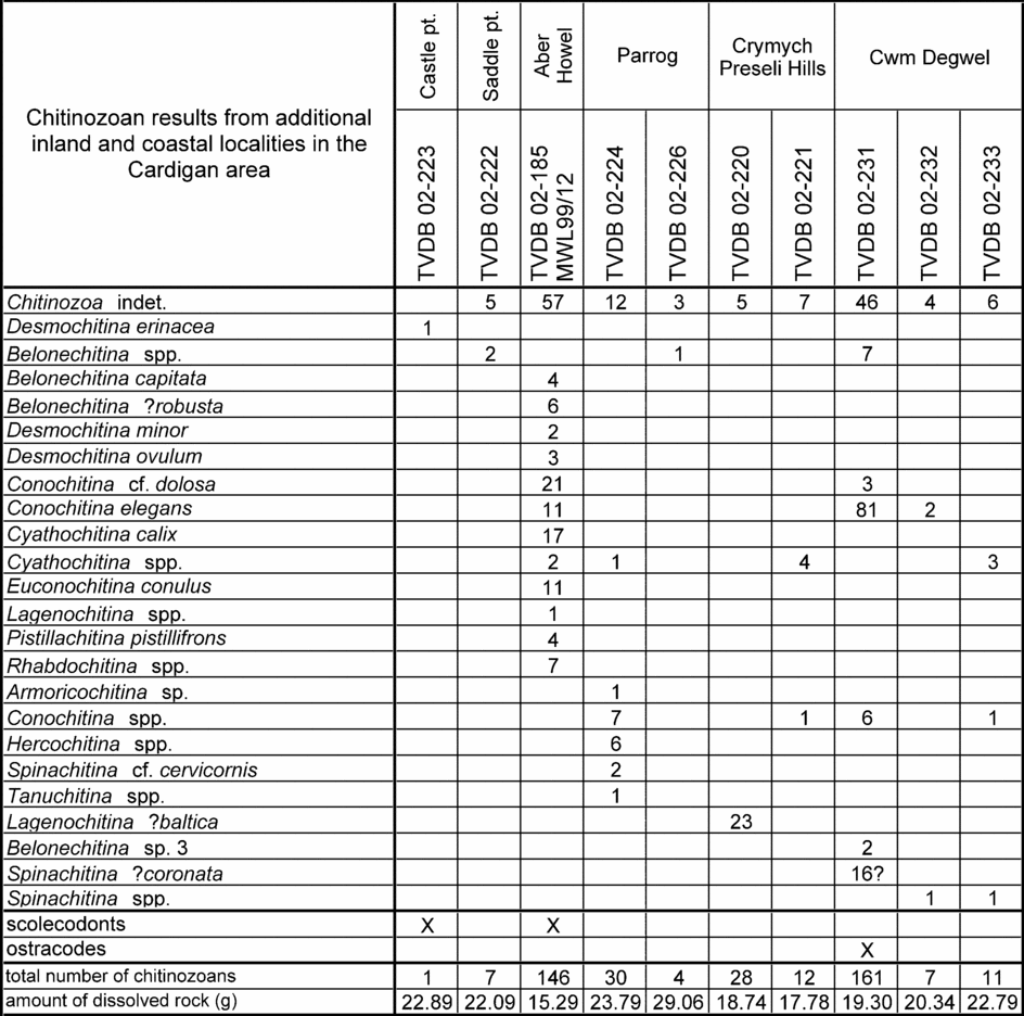
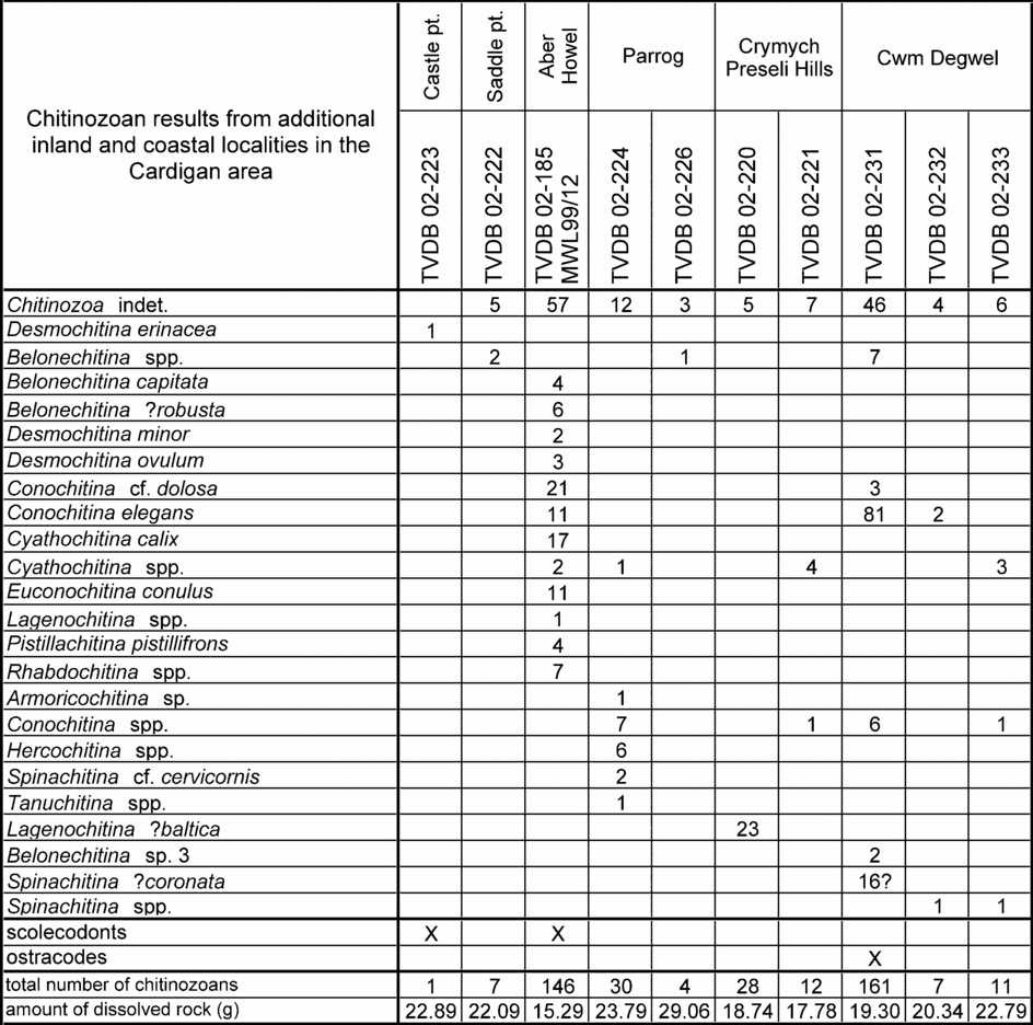
Numerical results from samples from inland and coastal localities in the Cardigan district, in addition to the samples from sections A to E as mentioned in Williams et al. (Reference Williams, Davies, Waters, Rushton and Wilby2003) and shown in Figure 4. The residue of all samples has been completely picked and investigated.
All sample localities are described in the Appendix; the samples are deposited at the Research Unit Palaeontology of Ghent University. In total, thirty-six samples from the Cardigan area and twenty samples from the Whitland road cutting were treated according to standard palynological techniques (Paris, Reference Paris1981).
5. Chitinozoan results
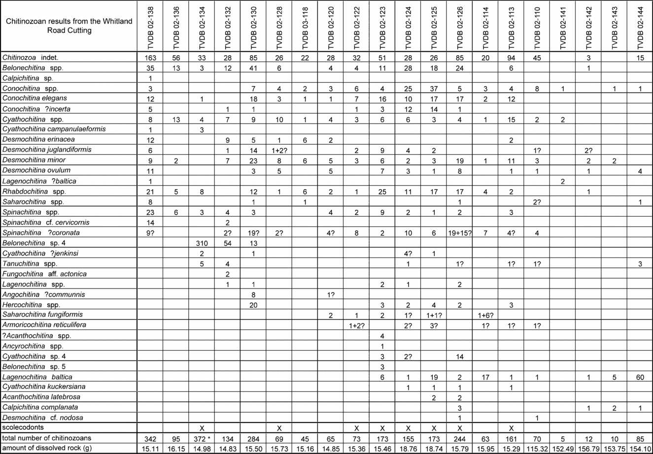
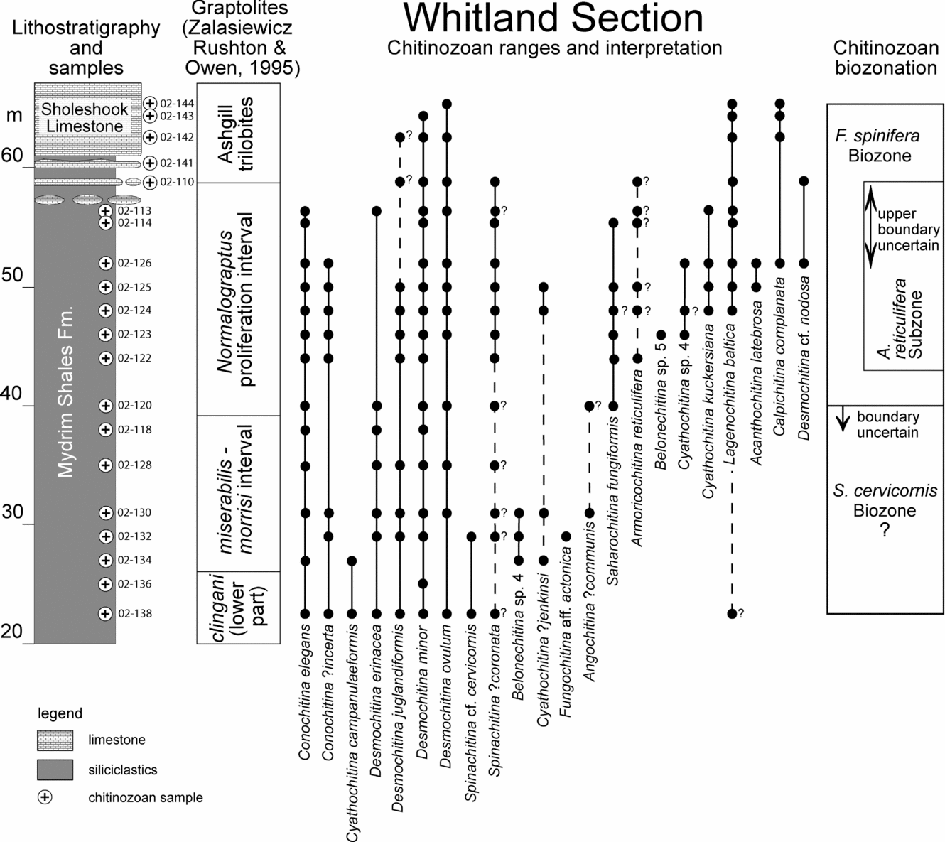
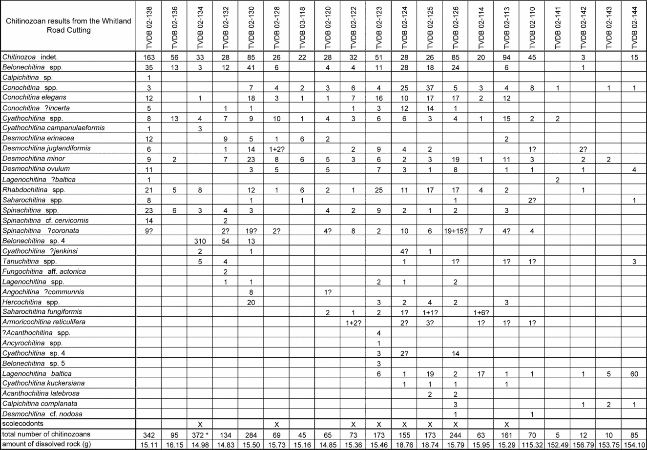
The results of the chitinozoan analysis are presented in Figures 4, 5 and 6. The first of these figures shows the results from sections A to E (as defined in Williams et al. Reference Williams, Davies, Waters, Rushton and Wilby2003) and the second figure shows the numerical results from several additional samples in the Cardigan area. The corresponding chitinozoan ranges are plotted on a composite stratigraphy (Fig. 3) that was constructed by Williams et al. (Reference Williams, Davies, Waters, Rushton and Wilby2003, p. 557) using key lithostratigraphical and graptolite data. In general, chitinozoan preservation is poor and yields were disappointing, but some levels yielded stratigraphically useful assemblages. Figure 6 quantitatively shows the results from the Whitland section as raw data. Figure 7 gives the range chart and the interpretation at the right hand side, described in section 6. Chitinozoans were recovered in sufficient quantities from the section but are not very well preserved and are commonly pyritized. A full systematic review of the chitinozoans from the study areas is contained in a Palaeontographical Society Monograph (Vandenbroucke, in press b). Some additional remarks are listed below.
Numerical results of the chitinozoan study in the Whitland section. * – about one-half of the residue picked.
Range chart of chitinozoan species and chitinozoan biozonation in the Whitland road cutting. Lithostratigraphical column modified after Zalasiewicz, Rushton & Owen (Reference Zalasiewicz, Rushton and Owen1995).
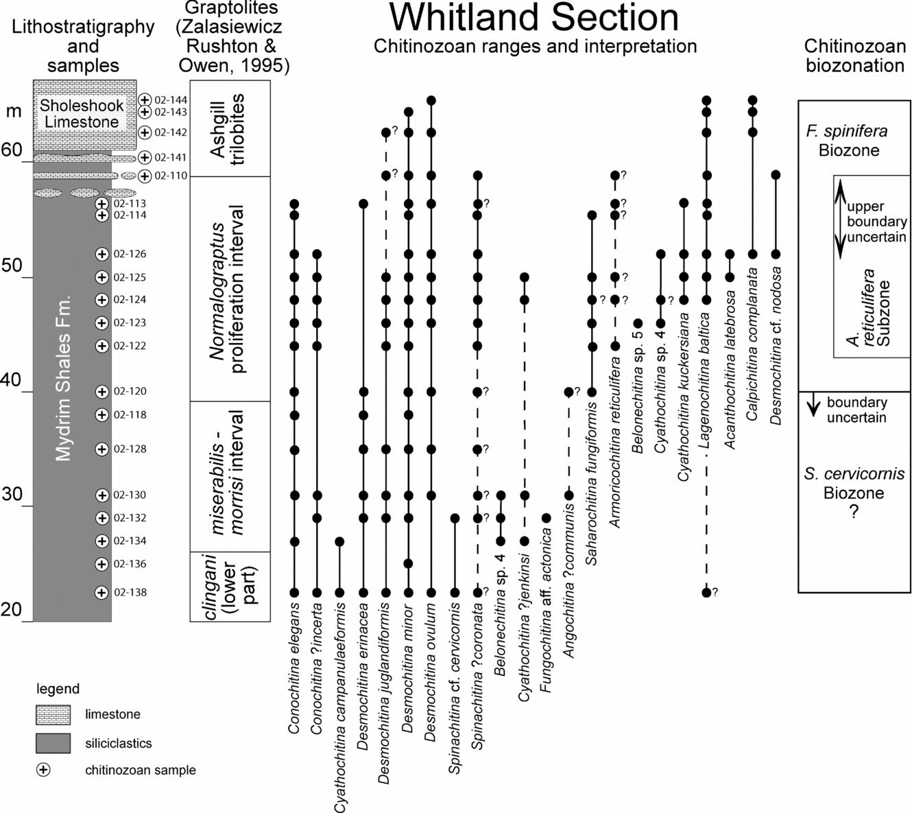
In Cardigan, the chitinozoan morphospecies Lagenochitina baltica and Lagenochitina prussica are combined, as distinction between them is often difficult. This group is recorded from sections C and D. Tanuchitina ?bergstroemi is reported only as fragments, but in considerable numbers, from section E. Spinachitina ?coronata has been recognized only provisionally in the lower half of the Whitland section but is identified with more certainty higher up in the section (see Fig. 6 for exact distribution). Belonechitina sp. 4, observed in several Whitland samples, is morphologically close to Belonechitina sp. 3 from the Cardigan area, although the poor preservation hampers formal synonymy.
6. Chitinozoan biostratigraphy
6.a. Cardigan area biozonation
Although not very well preserved or rich, the chitinozoan assemblages from several levels have good potential for biozonation and correlation, mainly with the Scandinavian chitinozoan biozonation (Nõlvak & Grahn, Reference Nõlvak and Grahn1993).
(1) Interval possibly referable to the Lagenochitina deunffi to Lagenochitina dalbyensis Biozone?. At Aber Howel (Sample 02-185), the chitinozoan fauna has, as its main constituents, Belonechitina capitata, Belonechitina? robusta, Conochitina cf. dolosa, Conochitina conulus, Conochitina elegans, Cyathochitina calix and Pistillachitina pistillifrons and is very similar to the northern Gondwanan assemblage shown in Henry et al. (Reference Henry, Nion, Paris and Thadeu1974). Paris (Reference Paris1990) established a formal biozonation for northern Gondwana and showed that P. pistillifrons has a short range within the Lagenochitina deunffi to Lagenochitina dalbyensis biozonal interval (Paris, Reference Paris1990, fig. 4, p. 189).
(2) Armoricochitina reticulifera chitinozoan Subzone of the Fungochitina spinifera chitinozoan Biozone. In sections C and D, the presence of Spinachitina ?coronata, Lagenochitina ?baltica, Lagenochitina prussica and Armoricochitina reticulifera are taken as indicative of the Fungochitina spinifera chitinozoan Biozone (Nõlvak & Grahn, Reference Nõlvak and Grahn1993; Nõlvak, Reference Nõlvak and Poldvere2005), although the index fossil itself has not been recovered. The recovery of A. reticulifera also allows the local recognition of the eponymous Baltoscandic chitinozoan subzone (Nõlvak & Grahn, Reference Nõlvak and Grahn1993) (Fig. 3).
(3) Tanuchitina ?bergstroemi Biozone. Higher in the Cardigan stratigraphy, Tanuchitina ?bergstroemi, a form close to the index fossil of the eponymous Baltoscandic chitinozoan biozone, has been identified tentatively from an isolated locality at Frongoch [SN 0749 4108]. There, it occurs at the level of the Pleurograptus linearis graptolite Biozone. Records of this chitinozoan species, though abundant, are all fragmentary, hence the open nomenclature and the caution needed in using this occurrence for correlation.
6.b. Whitland section biozonation
The chitinozoan biozonation in the Whitland section remains tentative as index fossils are rare. Further study ought to increase the accuracy of the boundaries drawn and the biozones defined. Nevertheless, the following biozones have been recognized in the Whitland section (Fig. 7).
(1) Spinachitina cervicornis Biozone?. The biozone has only tentatively been recognized because the index fossil has been provisionally identified as Spinachitina cf. cervicornis (occurring only in low numbers and in the lowermost part of the section). However, well-preserved specimens of Desmochitina juglandiformis have been recovered from several levels. D. juglandiformis is characteristic of the Spinachitina cervicornis Biozone in Baltoscandia, where both species have more or less the same short range (Nõlvak & Grahn, Reference Nõlvak and Grahn1993, p. 261). The occurrence of D. juglandiformis and to a lesser extent S. cf. cervicornis has therefore been used to identify the Spinachitina cervicornis Biozone? from the base of the sampled section up to the incoming of the index fossils of the overlying biozone.
(2) Fungochitina spinifera Biozone. For the history of this biozone we refer to the study dealing with the Cautley district (Vandenbroucke, Rickards & Verniers, Reference Vandenbroucke, Rickards and Verniers2005). As in the type Ashgill area, Saharochitina fungiformis is taken as the local index fossil of the biozone, but the same preservation problems as in the Cautley district have to be considered. It was recognized from sample 02-120, at the base of the Normalograptus proliferation interval, upwards. However, only a few specimens (7+8?) have been recovered. The presence of abundant (108) and easily recognizable Lagenochitina baltica specimens adds to the validation of the biozone, as L. baltica is considered a characteristic species, occurring slightly above the base of the original Fungochitina fungiformis Biozone in Nõlvak & Grahn (Reference Nõlvak and Grahn1993). The single specimen questionably attributed to L. baltica (Fig. 7), aberrantly found at the base of the section, is not attributed any biostratigraphical value.
(3) Armoricochitina reticulifera Subzone. The subzone was defined by Nõlvak & Grahn (Reference Nõlvak and Grahn1993) in Baltoscandia as corresponding to the total range of the index fossil, a definition applied here also. However, only one specimen has been positively identified; the remaining ten specimens are doubtful and hence kept in open nomenclature. The stratigraphical attribution of the biozone thus has to be treated with caution, although it helps to confirm the presence of the Fungochitina spinifera Biozone in the section. The first occurrences of A. reticulifera and Lagenochitina baltica appear to be inverted in comparison with their FADs given by Nõlvak & Grahn (Reference Nõlvak and Grahn1993).
7. Correlations and significance of the chitinozoan biozonation
In general, the chitinozoan stratigraphy supports the established graptolite biozonation, but there are potentially important implications for the age of the base of the Nantmel Mudstones Formation and the biostratigraphical position of the Normalograptus proliferation interval. The recognition of the Baltoscandic biozones leads, cautiously, to a reasonably accurate correlation with the Baltic chitinozoan scheme (Nõlvak & Grahn, Reference Nõlvak and Grahn1993), with certain levels from the Gondwanan biozonation (Paris, Reference Paris1990), and with several assemblages from northern England (Vandenbroucke, Rickards & Verniers, Reference Vandenbroucke, Rickards and Verniers2005).
7.a. Early Caradoc
The lowermost assemblage of interest has been recovered from strata assigned to the Diplograptus multidens Biozone by Williams et al. (Reference Williams, Davies, Waters, Rushton and Wilby2003) at Aber Howel. The chitinozoan fauna (see Sections 5 and 6.a), comparable to Gondwanan assemblages including P. pistillifrons (Henry et al. Reference Henry, Nion, Paris and Thadeu1974; Paris, Reference Paris1990), is possibly indicative of the Lagenochitina deunffi–Lagenochitina dalbyensis biozonal interval. Paris dated the range of P. pistillifrons to the Costonian–earliest Harnagian and placed the two chitinozoan biozones in the upper part of the N. gracilis and the lower part of the D. multidens graptolite biozones. The other chitinozoan species present tend to restrict the age assignment only to a (early) Caradoc age (Nõlvak & Grahn, Reference Nõlvak and Grahn1993). Chitinozoan correlations with Gondwana are thus consistent with the age and biozonal assignment suggested by Williams et al. (Reference Williams, Davies, Waters, Rushton and Wilby2003). Definite biozone attribution of the level remains impossible due to the lack of zonal index fossils.
7.b. Mid- to late Caradoc
In the Southern Uplands of Scotland, Desmochitina juglandiformis has been used in the Hartfell Score section to attribute the levels spanning the base of the Ensigraptus caudatus Subzone to the Spinachitina cervicornis Biozone or the Belonechitina robusta Biozone on Gondwana (J. A. Zalasiewicz et al. unpub. data, 2004: http://www.ordovician.cn). Finds from Whitland do not contradict this: D. juglandiformis ranges upwards from the lowermost Whitland sample, the base of the E. caudatus Subzone being situated below this level. The Spinachitina cervicornis Biozone is reported from the pre-Onnian strata in the Onny Valley (Vandenbroucke et al. Reference Vandenbroucke, Ancilletta, Fortey and Verniers2008), although there it was recognized by its index species, while D. juglandiformis has not been observed.
7.c. Late Caradoc–early Ashgill
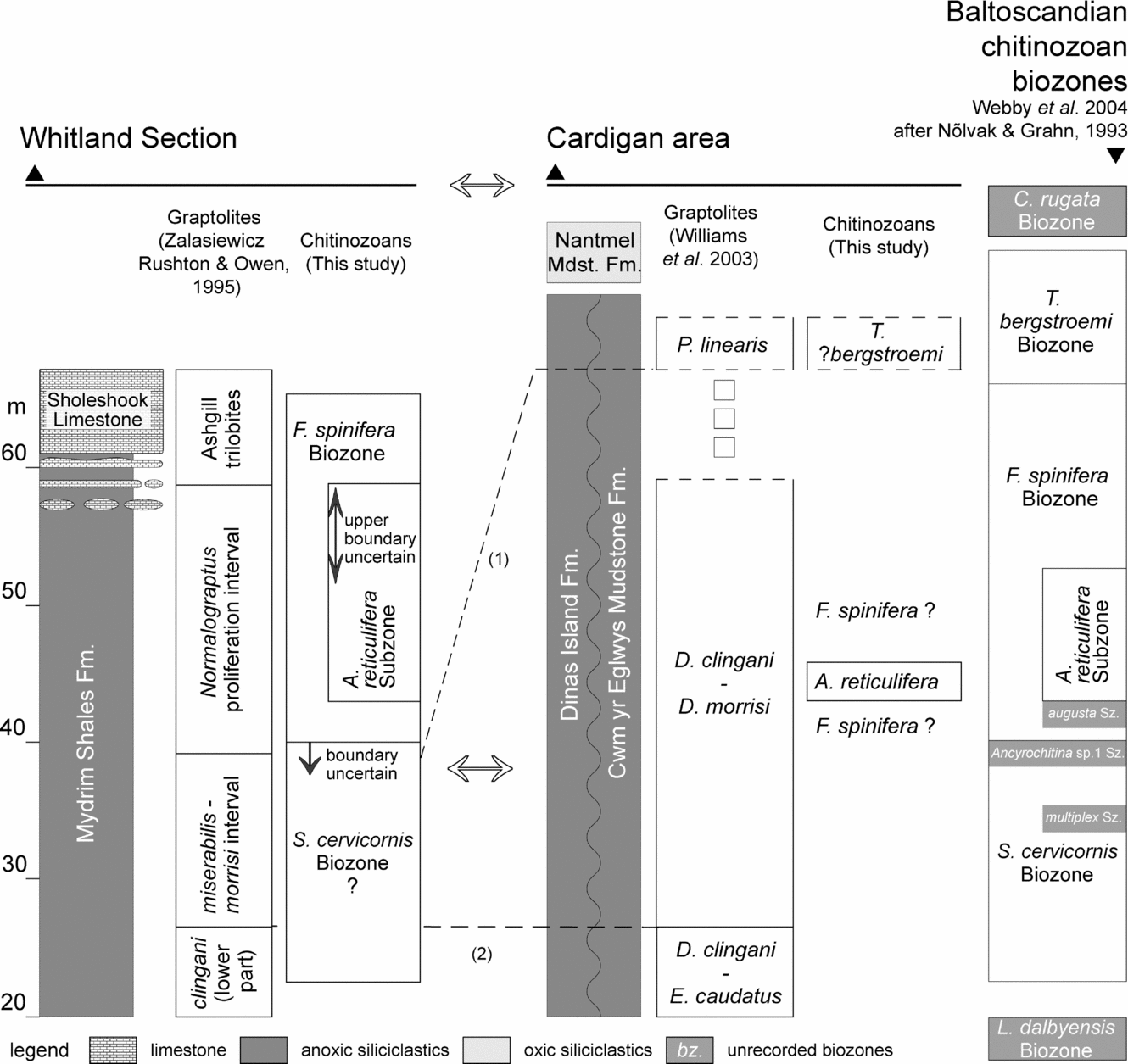
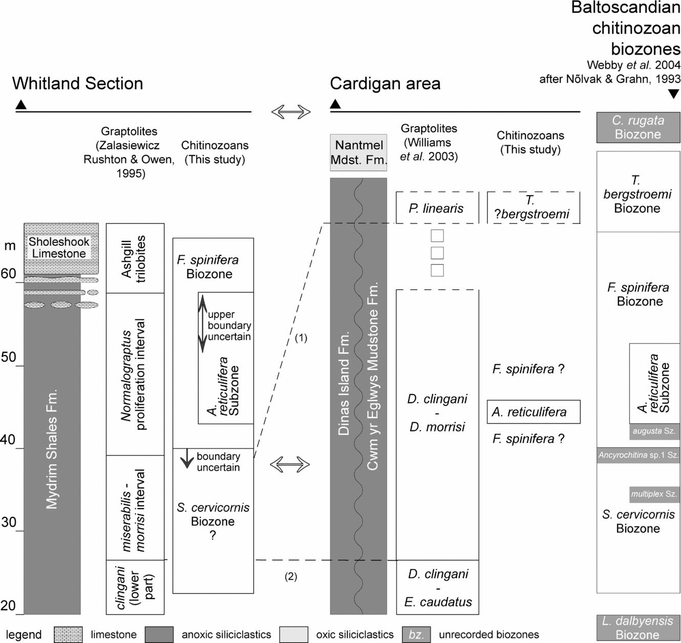
Within the Welsh Basin, interesting ties between the Cardigan and Whitland areas can be recognized (Fig. 8). Even given the minor uncertainties concerning its exact stratigraphical extent (see Section 6.b and Fig. 8), the Fungochitina spinifera Biozone–Armoricochitina reticulifera Subzone combination in the Normalograptus proliferation interval of the Whitland section can easily be linked with the same chitinozoan assemblages in the Cardigan area, where it is present in the Dinas Island and Cwm-Yr-Eglwys Mudstone formations in sections C and D. However, at the latter localities, the chitinozoan assemblages are associated with graptolites of the Dicellograptus morrisi Subzone of the Dicranograptus clingani Biozone (Williams et al. Reference Williams, Davies, Waters, Rushton and Wilby2003). The latter graptolite–chitinozoan link is considered stable, as A. reticulifera and D. morrisi graptolites are known to co-occur in the North Cliff Trench at Dob's Linn, Scotland (Verniers & Vandenbroucke, Reference Verniers and Vandenbroucke2006). Hence, rocks containing the reduced diversity Normalograptus graptolite assemblage at Whitland appear to correlate, at least in part, with rocks yielding D. morrisi faunas in the Cardigan area. This indicates that the ‘Normalograptus proliferation interval’ cannot correlate directly with the Pleurograptus linearis Biozone as proposed by Zalasiewicz, Rushton & Owen (Reference Zalasiewicz, Rushton and Owen1995). However, comparable Fungochitina spinifera Biozone chitinozoan assemblages, present in sections in northern England, are assigned an age of late Onnian to early Cautleyan. This is according to data from the Onnian and Pusgillian of Pus Gill (Cross Fell Inlier), the Pusgillian to lowermost Cautleyan of the Type Ashgill area (north of Sedbergh: Zalasiewicz, Rushton & Owen, Reference Zalasiewicz, Rushton and Owen1995) and the Greenscoe road cutting in the Lake District (Van Nieuwenhove, Vandenbroucke & Verniers, Reference Van Nieuwenhove, Vandenbroucke and Verniers2006). Hence, in the Whitland section, the continuation of the F. spinifera Biozone into the Sholeshook Limestone also supports the late Pusgillian/early Cautleyan dating of the lower part of this division suggested by the associated trilobites (Zalasiewicz, Rushton & Owen, Reference Zalasiewicz, Rushton and Owen1995 and based on Price, Reference Price1984). Taken together, these data suggest that (only) the upper part of the ‘Normalograptus proliferation interval’ might still correlate with the lower part of the linearis Biozone.
Correlation of the Whitland section with the Cardigan area using chitinozoans (most of the horizontal correlations) and graptolites (dashed line 2). One of the graptolite ties (dashed line (1) on the figure) suggested by Zalasiewicz, Rushton & Owen (Reference Zalasiewicz, Rushton and Owen1995) causes rather substantial discrepancies between the chitinozoan biozones of the two areas. It is therefore suggested that the correlation between the two areas using the Fungochitina spinifera Biozone/Armoricochitina reticulifera Subzone might be more accurate. This involves the correlation of the (lower) Normalograptus proliferation interval with levels of the Dicellograptus morrisi Subzone of the Dicranograptus clingani Biozone. Given that the Pleurograptus linearis graptolites are from an isolated locality at Frongoch [SN 0749 4108], there is some flexibility in the exact stratigraphical position of this biozone's boundary with the preceding biozone. The Baltoscandian chitinozoan biozonation is given at the right hand side of the figure as a reference.
Four specimens of Acanthochitina latebrosa, as defined in the Onny Shales Formation of the Onny Valley (of Onnian age), occur in samples 02-125 and 02-126. This means that correlation between these parts of the section at Whitland and the Onny Valley might be possible, although this would only be based on a small percentage of specimens in common, while the bulk of the assemblages in Whitland and the Onny Valley are rather different and hard to correlate. For a full discussion on the correlation potential, we refer to Vandenbroucke (in press a).
7.d. Ashgill
Taken at face value, the abundant chitinozoan fragments tentatively assigned to the index fossil T. ?bergstroemi at Frongoch carry implications, since they suggest a correlation with post-spinifera Biozone Cautleyan rocks in the Cautley type area (Vandenbroucke, Rickards & Verniers, Reference Vandenbroucke, Rickards and Verniers2005). Admittedly, in the Cautley district, rare specimens comparable to T. bergstroemi are found at the top of the F. spinifera Biozone, of Cautleyan age (Vandenbroucke, Rickards & Verniers, Reference Vandenbroucke, Rickards and Verniers2005); however, this is stratigraphically immediately below the appearance of true T. bergstroemi at the base of the eponymous biozone. If the presence of T. bergstroemi can be confirmed in the Cardigan area, its association with P. linearis Biozone graptolites at Frongoch would also lend support to the findings of Rickards (Reference Rickards2002, Reference Rickards2004), that is, that this biozone ranges into the Cautleyan and younger rocks. Such chitinozoan-based correlation would also imply that the anoxic–oxic transition which defines the base of the Nantmel Mudstones Formation, previously taken as the Caradoc–Ashill boundary in the Cardigan area, and throughout mid-Wales, is in fact Cautleyan or younger in age; the true base of the Ashgill would hence be lower in the rock succession than suggested previously. It would also follow, contrary to current thinking (Fortey et al. Reference Fortey, Harper, Ingham, Owen, Parkes, Rushton and Woodcock2000), that the base of the Nantmel Mudstones Formation in the basin is younger than the base of the shelfal Sholeshook Limestone at Whitland. Given these implications, confirmation of the presence of T. ?bergstroemi at Frongoch, and in equivalent strata elsewhere, should be viewed as an urgent requirement.
One significant implication of these results is that the Caradoc–Ashgill boundary in Wales (and in the Southern Uplands of Scotland) might lie within continuously graptolite-bearing strata. Locating this level more precisely would not only aid regional correlation, it would help constrain whether or not marked palaeoenvironmental changes (the anoxic to oxic switch at the base of the Nantmel Mudstones Formation; the switch to limestone deposition represented by the Sholeshook Limestone) were synchronous, thus helping assess their significance for early Palaeozoic climate evolution (Page et al. Reference Page, Zalasiewicz, Williams, Popov, Williams, Haywood, Gregory and Schmidt2007).
8. Conclusions
Palynological analysis of rock samples collected for graptolites from the Cardigan and Whitland areas of SW Wales provides the following stratigraphical results from chitinozoans.
(1) At Aber Howel, low in the Caradoc rock succession at Cardigan, the chitinozoan fauna has P. pistillifrons that indicates the Costonian–earliest Harnagian, and thus the chitinozoan correlations confirm the age and biozonal assignment of D. multidens suggested by Williams et al. (Reference Williams, Davies, Waters, Rushton and Wilby2003) from the graptolites.
(2) Finds of the subzonal index fossil Armoricochitina reticulifera within the Newport Sands section (clingani graptolite Biozone, morrisi Subzone) together with Spinachitina? coronata, Lagenochitina ?baltica and Lagenochitina prussica, indicate the F. spinifera chitinozoan Biozone, known from several sections in northern England where it spans the lower boundary of the Ashgill Series.
(3) The link between the Armoricochitina reticulifera chitinozoan Subzone and the D. morrisi graptolite Subzone confirms the findings of Verniers & Vandenbroucke (Reference Verniers and Vandenbroucke2006) at Dob's Linn, Scotland.
(4) Fragmentary chitinozoans suggestive of the T. ?bergstroemi chitinozoan Biozone, from a level within the Pleurograptus linearis graptolite Biozone, indicate that upper parts of the Cwm-yr-Eglwys Mudstone Formation might correlate with strata of Cautleyan age in the type Ashgill area. If confirmed, this would imply that the widespread Welsh Basin anoxic–oxic transition at the base of the Nantmel Mudstones Formation is also Cautleyan (or younger) in age, and that the Caradoc–Ashgill boundary must lie at a lower level within the Cwm-yr-Eglwys or Dinas Island formations.
(5) Chitinozoans from the Whitland road cutting allow recognition of two Baltoscandian biozones and a subzone, mainly by using accessory species rather than the index fossils. From bottom to top, the following biozones are present: Spinachitina cervicornis Biozone?, Fungochitina spinifera Biozone and Armoricochitina reticulifera Subzone.
(6) Comparison of the Whitland assemblages with those of the Cardigan area suggests that at least the lower part of the Normalograptus proliferation interval of the Whitland section might better be attributed to the Dicellograptus morrisi Subzone of the Dicranograptus clingani Biozone rather than to the Pleurograptus linearis Biozone as previously suggested.
Acknowledgements
We thank Richard Fortey (The Natural History Museum, London), Derek Siveter (Oxford University) and Brian Chatterton (University of Alberta) for assistance in the field, Stewart Molyneux (BGS) for providing literature, the BGS central Wales mapping team and the Ludlow Research Group for interesting debate in the field, Jan Vanmeirhaeghe (Ghent University), Florentin Paris (University of Rennes I, CNRS) and Jaak Nõlvak (Tallinn University of Technology) for help with identifications, Sabine Vancauwenberghe for the laboratory preparations, and Jacques Verniers, Stephen Louwye, Achilles Gautier (Ghent University), Florentin Paris (University of Rennes I, CNRS) and Aicha Achab (INRS-ETE, University of Quebec) for commenting on an earlier version of this paper (as part of TVDB's Ph.D. jury). The helpful comments of Phil Wilby (BGS), Adrian Rushton and one anonymous reviewer greatly improved the manuscript. This paper is a contribution to the IGCP 503 project (Ordovician Palaeogeography and Palaeoclimate). FWO-Flanders is sincerely acknowledged for funding our projects. J. R. Davies publishes with the permission of the Executive Director, British Geological Survey (NERC).
Appendix 1. Sample localities
Cardigan–Fishguard area
Cardigan area: sub-samples Williams et al. (Reference Williams, Davies, Waters, Rushton and Wilby2003) collection
For each sample sub-sampled from the BGS collections the sample labels of the Williams et al. (Reference Williams, Davies, Waters, Rushton and Wilby2003) paper (A.* to E.*), the BGS field labels (e.g. 99/16 or boat*) and BGS storage labels (MWL/Tray) are indicated, together with the TVDB – sub sample label.
Section A (see Fig. 2): Ogof Cadno to Cemaes Head
A.1: scree, base of cliff, fault zone S of Ogof Cadno [SN 0917 4399]
Boat 3; MWL 1034-1047/Tray 25903; TVDB 02-199
A.3: top of cliff at Carreg Bica/Ceibwr [SN 0926 4420]
C.2; MWL 629–650/Tray 25512; TVDB 02-180
A.4: Traeth Bach, S side of bay, foot of cliff/Ceibwr [SN 1014 4506]
C.3; MWL 737-750/Tray 25513; TVDB 02-182
A.5: Traeth Bach, near end of headland, S side of bay/Ceibwr [SN 1012 4508]
C.1; MWL 651-735/Tray 25512; TVDB 02-181
Section B (see Fig. 2): Dinas Island
B.1: S side of bay at Cwm-yr-Eglwys [SN 0155 4004]
99/1; MWL 2103-2148; TVDB 02-195
B.3: N side of small embayment at Pwllgwaelod [SN 4035 3995]
2001/6; MWL 5298-5304; TVDB 0196
B.5: centre of small bay just SE of Catch y Mitsiwr [SN 0026 4022]
99/15; MWL 2757-2782; TVDB 02-186
B.6: crags at top of cliff to the E of Catch y Mitsiwr [SN 0024 4025]
2001/1; MWL 5227-5249; TVDB 02-187
B.11: scree from near centre of bay Aber Pensidan [SN 0011 4075]
99/18; MWL 2817-2831; TVDB 02-197
Section C (see Fig. 2): Treath Cell-Howel to Cardigan (Afon Teifi)
C.'a': S of Ogof Cadno, scar 2/3 from the top of the cliff [SN 0905 4380]
SPT/MW/97/4; MWL 955-963/Tray 25902; TVDB 02-189
C.1: S bank just east of river bend [SN 1712 4602]
PT 10; MWL 5200-5226; TVDB 02-192
C.3: S bank, 60 paces downstream from effluent outflow [SN 1696 4600]
PT7; MWL 824-834, 879-890/Tray 25902; TVDB 02-193
C.5: S bank, 60 paces downstream from C4 [SN 1687 4598]
(C4: opposite rocky cliff on N bank)
PT 9; MWL 807-812/Tray 25514; TVDB 02-194
C.6: at small bridge over tributary on the Afon Teifi [SN 1755 4605]
‘Keeping locality’; MWL 858-878/Tray 25515 & MWL 981-1007/Tray 25903; TVDB 02-183
Section D (see Fig. 2): Newport Sands
D.1: shoreline exposure at high water mark [SN 0543 4067]
P4; MWL 2192-2202 & 5305-5327; TVDB 02-191
D.3: cave at high water mark on shoreline [SN 0539 4080]
P1; MWL 388-428/Tray 25509; TVDB 02-175
D.5: shoreline exposure on large reef [SN 0540 4088]
P3; MWL 439-455/Tray 25508; TVDB 02-176
D.7: shoreline exposure, at base of cliff [SN 0542 4099]
N7; MWL 466-482/Tray 25508; TVDB 02-190
D.11: shoreline exposure, about 3 m of Pen Pistyll [SN 0538 4111]
N1; MWL 483-531/Tray 25508&25509; TVDB 02-177
D.14: 39 paces N of Pen Pistyll [SN 0535 4118]
N4; MWL 576-596 & MWL 906-941/Tray 25510, 25511 & 25902; TVDB 02-179
D.15: shoreline exposure, 12 paces N of Pen Pistyll [SN 0535 4118]
N2; MWL 540-545/Tray 25510; TVDB 02-178
D.16: 49 paces N of Pen Pistyll [SN 0535 4118]
N5; MWL 597-615/Tray 2551: TVDB 02-188
D.18: Traeth y Bâl, at base of cliff on N side of bay [SN 0525 4225]
boat 1; MWL 1008-1023/Tray 25903; TVDB 02-198
Section E (see Fig. 2): Frongoch
E.4: steam bed, 52 paces upstream from old stone bridge [SN 0749 4108]
99/8; MWL 2246-2272; TVDB 02-184
Aber Howel; 99/12; MWL 2414-2468; TVDB 02-185 [SM 9905 3852]
Cardigan area: Field collection 2002
TVDB 02-220: Crymych, Preseli Hills [SM 185 339]; blacks shales of the Mydrim Shales Formation, more or less at the E. caudatus- D. morrisi transition in the D. clingani Biozone (Fig. 2, locality 6); sample at 1/3 of the outcrop length from the eastern margin of the outcrop, and 2/3 of the outcrop length from the bridge in the W.
TVDB 02-221: Crymych, Preseli Hills [SM 185 339]; blacks shales of the Mydrim Shales Formation, in the upper D. clingani Biozone (D. morrisi) (Fig. 2, locality 6); sample at 0.5m east of the bridge at the western margin of the outcrop.
TVDB 02-222: Saddle Point, Fishguard foreshore, mudstone (matrix?) of the Saddle Point Member of the Penyraber Mudstones Formation, stratigraphically below rafts with D. multidens fauna at another locality.
TVDB 02-223: Castle Point [SM 962 377], at the basal disconformity of the sedimentary succession on the Fishguard Volcanic Group; sample in the Castle Point Member of the Penyraber Mudstones Formation, stratigraphically 2 m above the top of the volcanics (or less possibly a large siltstone clast in the volcanics).
TVDB 02-224: Parrog [SN 0459 3977] along the shore between Newport and Dinas Island; sample in the oxic, mottled Penyraber Mudstone Formation at 45 to 50 cm above a 15 cm thick, obvious quartz vein, exactly at the site of a small hollow under the path on top of the low cliff.
TVDB 02-226: Parrog [SN 0459 3977] along the shore between Newport and Dinas Island; sample is a phosphatic nodule taken in the mottled Penyraber Mudstone Formation at about 0.5 to 1 m higher in the stratigraphy than TVDB 02-224, 5 paces more to the E
TVDB 02-228: Frongoch quarry; [SN 0759 4098]; Cwm-Yr-Eglwys Mudstones Formation, in between Locality 1 and 2, but closer to locality 2 in section E of Williams et al. (Reference Williams, Davies, Waters, Rushton and Wilby2003), both near the W end of the Quarry, see Fig. 2; D. clingani Biozone.
TVDB 02-229: Newport Sands section (Section D); [SN 0538 4111]; locality D.10 of Williams et al. (Reference Williams, Davies, Waters, Rushton and Wilby2003), about 4 m S of Pen Pistyll on shoreline; D. clingani Biozone; 60-67 cm under a 11.5 cm thick sandstone layer in the Dinas Island Formation.
TVDB 02-231: Cwm Degwel [SN 1635 4540], at the transition from the anoxic Dinas Island Formation lithology into the grey, mottled Nantmel Mudstones Formation, or at the assumed base of the Ashgill; at ± 1 m below the facies transition.
TVDB 02-232: Cwm Degwel [SN 1635 4540], at the transition from the anoxic Dinas Island Formation lithology into the grey, mottled Nantmel Mudstones Formation, or at the assumed base of the Ashgill; at the facies transition.
TVDB 02-233: Cwm Degwel [SN 1635 4540], at the transition from the anoxic Dinas Island Formation lithology into the grey, mottled Nantmel Mudstones Formation, or at the assumed base of the Ashgill; ± 1 m above the facies transition.
Whitland Road Cutting
The Whitland section [SN 1697 1599–1713 1598] is a road cutting along the A40, 3 km west of Whitland in southern Wales
TVDB 02-138: eastern part of the outcrop, about 22.3 m above the base of the section, 4.8 m east of the TVDB 02-136 locality. Mydrim Shales Formation.
TVDB 02-136: eastern part of the outcrop, 25 m above the base of the section. Mydrim Shales Formation.
TVDB 02-134: eastern part of the outcrop, 27 m above the base of the section. Mydrim Shales Formation.
TVDB 02-132: eastern part of the outcrop, 29 m above the base of the section (2 m below the ‘31 m mark’ of Zalasiewicz, Rushton & Owen (Reference Zalasiewicz, Rushton and Owen1995), which is still visible on the rock face). Mydrim Shales Formation.
TVDB 02-130: eastern part of the outcrop, 31 m above the base of the section, at the ‘31 m mark’ of Zalasiewicz, Rushton & Owen (Reference Zalasiewicz, Rushton and Owen1995), which is still visible on the rock face. Mydrim Shales Formation.
TVDB 02-128: eastern part of the outcrop, 35 m above the base of the section (2 m below the ‘37 m mark’ of Zalasiewicz, Rushton & Owen (Reference Zalasiewicz, Rushton and Owen1995), which is still visible on the rock face). Mydrim Shales Formation.
TVDB 02-118: eastern part of the outcrop, 38 m above the base of the section, at the ‘38 m mark’ of Zalasiewicz, Rushton & Owen (Reference Zalasiewicz, Rushton and Owen1995), which is still visible on the rock face. Mydrim Shales Formation.
TVDB 02-120: eastern part of the outcrop, 40 m above the base of the section, at the ‘40 m mark’ of Zalasiewicz, Rushton & Owen (Reference Zalasiewicz, Rushton and Owen1995), which is still visible on the rock face. Mydrim Shales Formation.
TVDB 02-122: eastern part of the outcrop, 44 m above the base of the section (between the ‘42 and 48 m marks’ of Zalasiewicz, Rushton & Owen (Reference Zalasiewicz, Rushton and Owen1995), which are still visible on the rock face). Mydrim Shales Formation.
TVDB 02-123: eastern part of the outcrop, 46 m above the base of the section. Mydrim Shales Formation.
TVDB 02-124: eastern part of the outcrop, 48 m above the base of the section. Mydrim Shales Formation.
TVDB 02-125: eastern part of the outcrop, 50 m above the base of the section. Mydrim Shales Formation.
TVDB 02-126: eastern part of the outcrop, 52 m above the base of the section. Mydrim Shales Formation.
TVDB 02-114: western part of the outcrop, 2.97 m to 3.00 below the limestone layer described in TVDB 02-110; about 55 m above the base of the section. Mydrim Shales Formation.
TVDB 02-113: western part of the outcrop, 1.93 m to 1.98 below the limestone layer described in TVDB 02-110; about 56 m above the base of the section. Mydrim Shales Formation.
TVDB 02-110: western part of the outcrop, 58 m above the base of the section, in the lowest, continuous, clearly observable limestone layer of the Sholeshook Limestone Formation, indicated as the one which yielded ‘Ashgill trilobites’ (R. Fortey, pers. comm. 2002); see Zalasiewicz, Rushton & Owen (Reference Zalasiewicz, Rushton and Owen1995).
TVDB 02-141: western part of the outcrop, stratigraphically 2 m above TVDB 02-110 or 60 m above the base of the section; 42 paces east of the western edge of the road cutting. Sholeshook Limestone Formation.
TVDB 02-142: western part of the outcrop; stratigraphically 4 m above TVDB 02-110 or 62 m above the base of the section; 42 paces east of the western edge of the road cutting. Sholeshook Limestone Formation
TVDB 02-143: western part of the outcrop; stratigraphically about 2 m above TVDB 02-142 or about 64 m above the base of the section; 42 paces east of the western edge of the road cutting. Sholeshook Limestone Formation.
TVDB 02-144: western part of the outcrop; stratigraphically 2.75 to 2.95 m above TVDB 02-142 or about 65 m above the base of the section; 44 paces east of the western edge of the road cutting. Sholeshook Limestone Formation.