Introduction
Abandoned sites and waste management in East Antarctica
The management of legacy waste is a significant problem at old stations, where waste management practices were of a significantly lower standard than they are today (COMNAP 2007). In most cases, waste generated on stations prior to the enacting of the Madrid Protocol (1991) was either incinerated, placed in landfill sites or disposed of at sea (Stark and others Reference Stark, Snape and Riddle2006). Environmental values have been damaged by this practice (COMNAP 2007) and several waste disposal sites exist around the main Australian stations in East Antarctica. One particularly large site exists on Clark Peninsula, where an old base (Wilkes) and its associated waste remain largely in situ, over 40 years after the site was abandoned.
The Madrid Protocol (1991), Annex I (Environmental Impact Assessment) and Annex III (Waste Disposal and Waste Management), Article 1 (5), establishes the obligation that
past and present waste disposal sites on land and abandoned work sites of Antarctic activities shall be cleaned up by the generator of such wastes and the user of such sites. This obligation shall not be interpreted as requiring: (a) removal of any structure designated as a historic site or monument; or (b) the removal of any structure or waste material in circumstances where the removal by any practical option would result in greater adverse environmental impact than leaving the structure or waste material in its existing location.
Although several Australian Antarctic Division (AAD) reports from the 1980s recognised that there were contaminated sites at Wilkes, there had been no systematic attempt to classify the waste that remains, or define the spatial scale of the problem. Such information is necessary for the development of strategic and systematic clean-up or preservation programmes.
An unpublished report by Snape and others (Reference Snape, Cole, Gore, Riddle and Yarnell1998) details a preliminary site assessment to classify the waste. This was followed by ground-truthing and Geographical Information Systems (GIS) database development by Babicka (Reference Babicka2000). No further examination of the waste was undertaken until the summer season of 2009/10. Baseline information is required to determine the extent and volume of waste, the types of waste and their potential for contamination so that strategies can be developed to appropriately manage, remediate or preserve the sites. These datasets must provide reliable, up-to-date information on the type, distribution and eventual fate and transport of contamination.
The site assessment presented in this article comprises two sets of results. First, we present a history of the Wilkes site and clean-up operations that have occurred over several decades. Second, we characterise the type and spatial extent of both hazardous and non-hazardous waste, and heritage items that remain at Wilkes. We discuss how the spatial distribution of different categories of waste provides information on the potential extent of contamination across Clark Peninsula. This information is important so that realistic and cost-effective clean-up strategies can be designed that remove, remediate or preserve waste at the Wilkes site.
Location and history of Wilkes Station
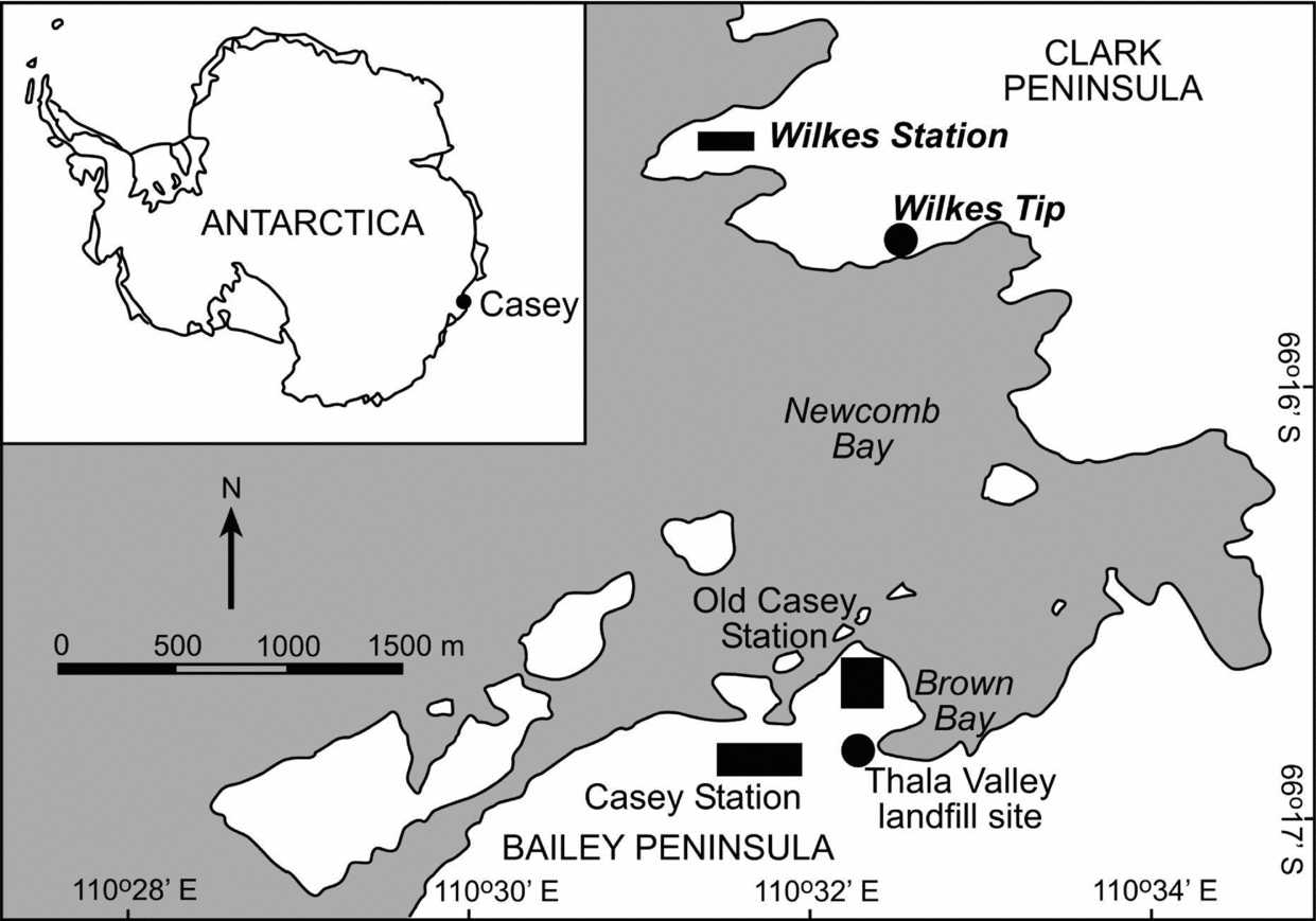
Wilkes Station is situated on Clark Peninsula (66°15′25.6″S 110°31′32.2″E) in the Windmill Islands, East Antarctica (Fig. 1). It is situated approximately 3km north of Casey Station across Newcomb Bay. Immediately east is an Antarctic Special Protection Area (ASPA 136) that was established for the protection and study of mosses and lichens, which contains an Adélie penguin colony. The ASPA boundary was adjusted in 2009 to accommodate a new access route to Wilkes (ATCM 32 2009).
Location of Wilkes Station in East Antarctica.

Wilkes Station was established by the United States in 1957 as part of the International Geophysical Year (IGY). The primary aim of its construction was to provide a strategically located base in East Antarctica from which scientific research and exploration could be conducted. The station was originally intended to be staffed for two years. Over 100 navy personnel from the United States constructed the main part of Wilkes over 16 days (McMahon Reference McMahon1967) (Fig. 2). During its construction over 11,000 tonnes of supplies were landed, including building materials, fuel and scientific equipment (McMahon Reference McMahon1967). The station housed up to 24 people at any time. The buildings have a concrete foundation and wooden superstructures (Snape and others Reference Snape, Cole, Gore, Riddle and Yarnell1998). Scientific studies during the IGY programme included ionospheric physics, cosmic rays, geomagnetism, seismology, glaciology, meteorology and biology (McMahon Reference McMahon1967). Several traverses, including those to Vostok and Totten Glacier, started from Wilkes Station.
Construction of Wilkes Station in 1957. All photographs Australian Antarctic Division, Copyright Commonwealth of Australia. Reproduced with permission.
In February 1959, operational and administrative control of the station was transferred to Australia. As part of the handover, the Australian Government accepted custody of the equipment and installations at Wilkes Station without charge or liability (ADEF 1959). The property would be returned, upon mutual agreement, to the custody of the United States at some future stage (ADEF 1959).
During its 10 years as an operational base, minor alterations and additions to existing buildings occurred. In 1962 a scientific laboratory, a micro-meteorology hut, a fuel tank stand, a store, a hydrogen generator hut and a balloon release building (destroyed later in the year by strong winds) were built (Anon. 2012). In total around 45 buildings made up the main Wilkes Station site (Fig. 3). A fuel farm and landfill site were later established adjacent to the main landing site on Newcomb Bay and are visible on the 1967 air photographs of the site. Additional building and fuel supplies were unloaded at Wilkes until 1969. Station records and reports indicate that surplus supplies that were shipped into Wilkes were not moved from their landing positions and became covered in snow (Clark and Wishart Reference Clark and Wishart1989). The volume of this material remains unknown.
Layout of Wilkes Station buildings as of 1967 (Wilkes Development Plan).
Wilkes was not designed or located for long-term occupation. High snow accumulation, possibly coupled with fuel contamination around buildings with an attendant high fire risk, led Australia to abandon Wilkes in favour of ‘old’ Casey Station in 1969 (Fig. 4). Much of the Wilkes Station equipment, fuel and buildings were abandoned and the majority of material remains on Clark Peninsula.
Wilkes Station in 1959 and 1958. (a) Photograph by Alan Campbell-Dury, Australian Antarctic Division, Copyright Commonwealth of Australia. Reproduced with permission. (b) Photographs from http://www.wilkesstationhistory.com. Reproduced with permission.
Wilkes Station is not on the List of Historical Sites and Monuments approved by the Antarctic Treaty Consultative Meeting (ATCM). However, Wilkes Station does have local value to the Americans and Australians who spent time at the station and to explorers who visit the site to view the remains (Anon. 2012). Several graves of former Wilkes members of staff lie along Remembrance Ridge. As such, Wilkes Station is listed as an ‘indicative place’ on the Register of the National Estate of the Australian Heritage Commission (AHC 2011). This raises significant questions about the heritage status and value of the site and the protocols relevant to protection, clean-up and waste treatment operations at Wilkes Station.
As part of this study, four areas have been designated that cover the affected area on Clark Peninsula (Fig. 5). Area 1 encompasses Remembrance Ridge; Area 2 is the main fuel farm and tip site; Area 3 is the Wilkes Hilton and surrounds; and Area 4 is the main Wilkes Station site. These areas include all service and operational areas as well as the current Wilkes Hut (Wilkes Hilton; Fig. 5), which receives regular, overnight rest and recreation visitors from the nearby Casey Station and is the only currently inhabitable building on Clark Peninsula.
The distribution of different types of waste across four areas on Clark Peninsula.
Wilkes Station also encompasses low-lying depressions on the southern side of an adjacent ridge as the landing, fuel storage and tip areas. These areas are enveloped by streams as the summer melt progresses, dispersing contaminants into the nearby marine areas of Powell Cove, Noonan Cove and Newcomb Bay (Townsend and Snape Reference Townsend and Snape2008). In 1992 during a severe summer melt a large fuel slick was observed across Newcomb Bay (Fig. 6; S. Potter, personal communication).
1992 summer melt at Wilkes Station exposing significant volumes of waste that is near-permanently buried. Photographs by Graeme Snow, Australian Antarctic Division, Copyright Commonwealth of Australia. Reproduced with permission. (a) Looking east along buildings 32 and 33, with building 21 on the right. (b) Looking southwest: buildings 18 and 19 in the foreground on the left; buildings 15 and 17 on the right. Note the amount of scrap metal and construction waste and the number of fuel drums, which are normally buried and not included in this survey.
Methods
A range of information sources have been used to assess the history of clean-up operations at Wilkes and establish waste types and their distribution across Clark Peninsula. Data from historical records of station operations and past clean-up reports were used to piece together a history of clean-up operations and the development of policy for these operations. The site surveys conducted by Snape and others (Reference Snape, Cole, Gore, Riddle and Yarnell1998) and Babicka (Reference Babicka2000) were revisited and revised in the field to classify the types of waste found at Wilkes and map their distribution.
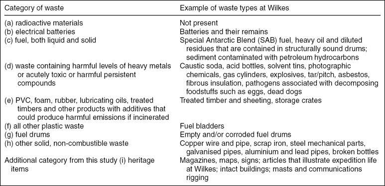
Article 2 in Annex III of the Madrid Protocol (1991) lists eight categories of waste for disposal by removal from the Antarctic Treaty Area. These categories have been adopted for this assessment. One additional category has been added to highlight those materials that may be considered heritage items, or items that illustrate expedition life at Wilkes and could be preserved. The categories relate to the type of waste, the degree of hazard presented by the waste, the heritage value of the waste and the potential for future waste management (Fig. 7; Table 1). Examples of the types of waste found at Wilkes that fall into each category are noted in Table 1.
Examples of waste found on Clark Peninsula based on the categories listed in Article 2, Annex III of the Madrid Protocol
Types of waste in each category. Photographs by K. Fryirs.
Data from a field survey conducted in January 1999 of drum condition and contents were also used (I. Snape, unpublished data). Babicka (Reference Babicka2000) developed a GIS platform, linked to Global Positioning System (GPS) coordinates and notes to document sites where waste is located. In 2009/10 a follow-up survey of waste type and distribution was conducted to update the database with additional sites and photographs. All these data were added to the database that is now held at the AAD. In 2009/10 around 220 water and sediment samples were collected across Clark Peninsula to determine the extent of heavy metal and hydrocarbon contamination generated by the waste. The latter results are reported in Fryirs and others (in press).
Results
Policy on, and history of, clean-up operations at Wilkes Station
To date, there has been an ad hoc, opportunistic and sparsely monitored approach to clean-up of the abandoned Wilkes Station (Snape and others Reference Snape, Cole, Gore, Riddle and Yarnell1998). Clean-ups that have occurred aimed to remove high-risk material that posed an occupational health and safety risk to visitors to the site. In 1983, Australian Army demolitions experts were charged with the responsibility of destroying stockpiles of explosives at Wilkes (Swallow Reference Swallow1986). While this operation was partly successful, there remain unexploded cylinders and explosives at Wilkes. In 1986/87 cases of caustic soda were removed from Wilkes.
In response to growing concern over the environmental impact of Wilkes, from both a clean-up and a preservation perspective, the AAD and the Antarctic Historical Sites and Monuments Advisory Committee (AHSMAC) proposed a phased clean-up in accordance with the Antarctic Treaty Consultative Committees in 1987 (Anon 1994). This proposal recommended:
1. limited clean-up but not removal of Wilkes;
2. limited restoration of the Radome and Transmitter huts for refuge and display use;
3. installation of a commemorative plaque detailing the IGY and life at Wilkes during its occupation by the American and Australian explorers; and
4. that remaining buildings be allowed to decay under the elements with occasional clean-up as necessary.
Further recommendations that were not fixed in policy were also made regarding a management plan for Wilkes, including:
1. developing a master plan to record the location of buildings and waste for historical posterity, before removal;
2. removing all dangerous material, although if there is no threat to the environment, intact cases, boxes and non-toxic material should be left in situ;
3. cessation of removal of historical artefacts by visiting explorers (including foodstuffs and equipment);
4. removing fuel drums from the site only after their position has been plotted; and
5. emptying fuel bladders but leaving platform and equipment in situ.
In response to these recommendations, in 1989, nine Australian Army engineers were instructed to clean up Wilkes. The engineers located and removed hazardous material, including 10 m3 of caustic soda, 110,000 litres of fuel and 4.5 m3 of ferrous silicate (Anon 1994). 350 gas cylinders were vented with bullets and 12kg of explosives were destroyed (Anon 1992). This was followed by a proposal for additional army engineers’ clean-up operations in 1991/92, 1992/93 and 1993/94. These operations were designed to vent remaining gas cylinders, burn explosives, decant fuel drums and repack boxes of caustic soda for return to Australia. Unfortunately, details of site locations and how much waste was actually removed from Wilkes were not recorded for any of these clean-up missions (Snape and others Reference Snape, Cole, Gore, Riddle and Yarnell1998). There is no further evidence to suggest that significant clean-up activity occurred after 1994.
It was not until 1998 that the AAD, with the support of the federal government, committed resources to develop an effective clean-up strategy for Australia's contaminated Antarctic sites (McDonald Reference McDonald1998). The first stage of clean-up of the waste disposal site at Thala Valley (Casey Station) was completed in 2011 with the extraction and return of the last of the waste. At Wilkes, removal of waste from the site since 2007 has been limited to ‘opportunistic pick-up of windblown debris’ under AAD policy (AAD 2010). Only very small volumes of wood scrap and wire that could be transported by all-terrain vehicle or sledge were removed during these operations. Systematic clean-up of Wilkes has not yet begun and remains unfunded.
Categories and types of waste found at Wilkes Station
This study classified 536 sites of waste across the four study areas. Each site contains one or more items of waste. Only the dominant type of waste at each site is noted. The counts do not include the buildings in the main Wilkes Station area. The survey also only includes materials that were at the surface during the survey periods. Historical, photographic evidence from the summer season of 1992, when a severe melt occurred, shows that the waste is much more extensive, particularly around the Wilkes Station buildings and at the tip area (Fig. 6). In any given year it is estimated that over 70% of the waste may be buried under snow and ice in the main Wilkes Station area and tip area.
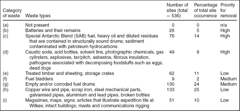
The dominant category of waste across Clark Peninsula is category h: other solid, non-combustible waste, which occurs at 25% of the identified sites (Table 2). This is followed by category g: fuel drums, which occur at 24% of the total sites surveyed. Category c: fuel, both liquid and solid, and category e: treated timber etc. occur at 14% and 12% of sites respectively. Category i: heritage items, category d: harmful metals and compounds, category b: electrical batteries and category f: plastic waste occur at less than 10 % of sites each. There are no category a: radioactive materials recorded at Wilkes (Table 2).
Number and percentage of sites at which different categories of waste occur and their priority for removal
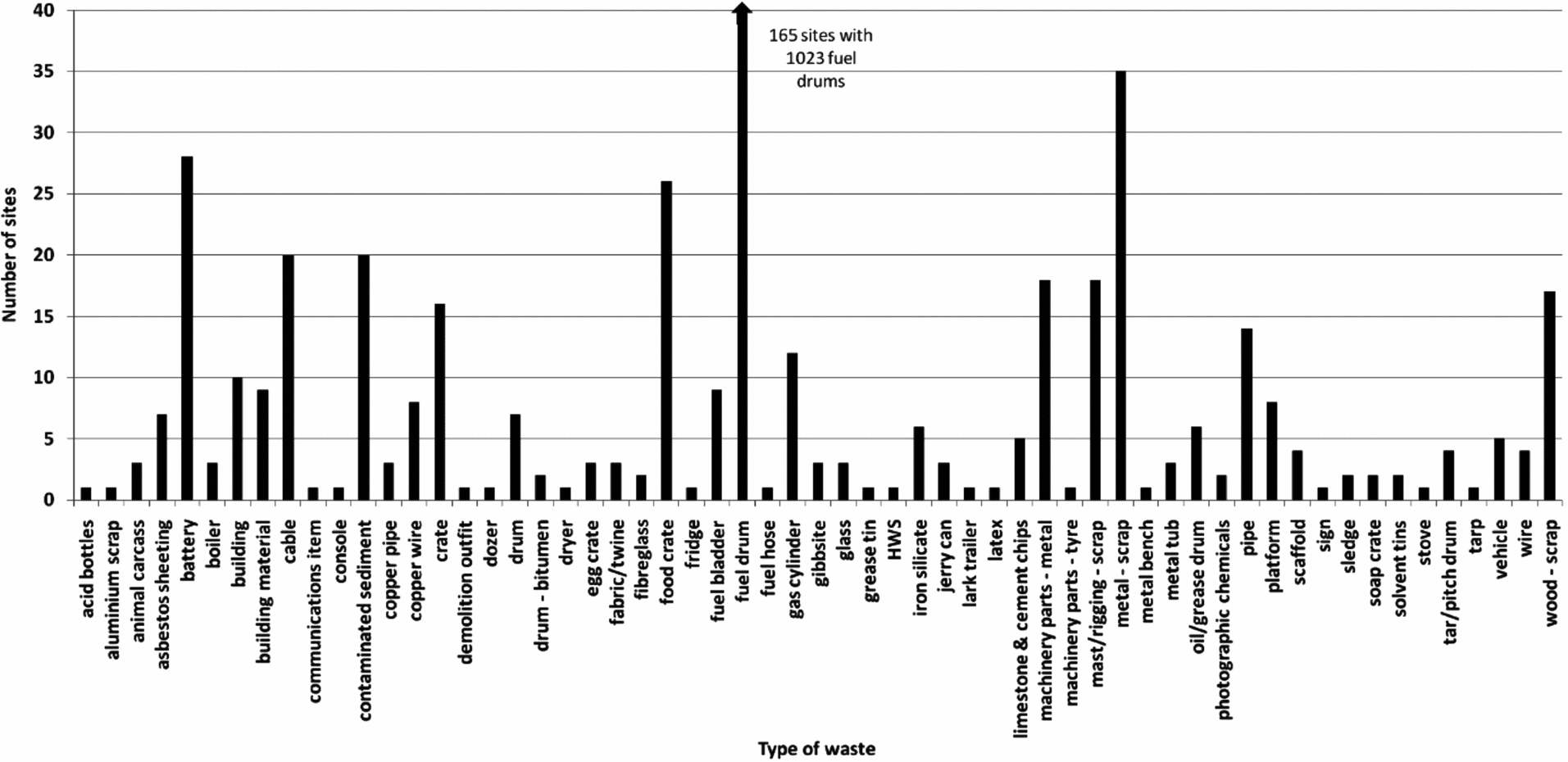
Waste items within categories are differentiated into 59 different types (Fig. 7 and Fig. 8). The most abundant type of waste is fuel drums (1023 drums across 165 sites). Of the 1023 drums (205L each) located and surveyed in 1999, 222 contained either Special Antarctic Blend diesel fuel, light fuel, lubricating oil, kerosene or liquid water that was rusty or contaminated. Around 8910 litres of these liquids remained contained within the drums. This is considered a conservative estimate as these data do not include volumes of liquid that remain in intact drums with irremovable lids, or volumes for drums that are buried in ice or under other drums and remain inaccessible. Associated with the drums are at least 20 sites of major sediment contamination. These patches are up to several square metres in size and predominantly located in conjunction with leaking fuel drums or rusting metal. The depth of infiltration of oil and fuel into the sediment has not been examined. This count does not consider the smaller patches of sediment that occur around almost every ruptured fuel drum on site, meaning that this problem is likely to be more extensive than previously thought (Snape and others Reference Snape, Cole, Gore, Riddle and Yarnell1998; Fryirs and others in press). This presents considerable concern for any clean-up operations.
The abundance of different types of waste across Clark Peninsula.
The next most abundant type of waste was metal scrap (35 sites), followed by waste from batteries (28 sites) and food crates (26 sites). Asbestos sheeting was identified at several locations independent of the main Wilkes Station buildings. Piles of gas cylinders remain in place at a number of locations (12 sites). Various forms of cable, wooden crates, copper pipes and wire, machinery parts, fuel bladders, wooden scrap, mast/rigging scrap and construction/building materials comprise the bulk of the remaining waste. Although items such as: acid bottles; tins of solvent and photographic chemicals; and drums of grease/oil, bitumen, limestone and cement chips, and tar/pitch are isolated (totalling 28 occurrences), they still pose an environmental risk and could be hazardous to the health of visiting explorers who might be exposed to them.
Area-by-area assessment
Wilkes is a large, complex contaminated area. Estimates place the total volume of waste at approximately 20,000m3 at the tip site alone (Snape and others Reference Snape, Cole, Gore, Riddle and Yarnell1998). The volume of contaminated sediment and historical items (including historically insignificant ones) is yet to be measured (Snape and others Reference Snape, Cole, Gore, Riddle and Yarnell1998). Much of the material is strewn over an area of 1 km × 1.5 km.
Area 1: Remembrance Ridge
The Remembrance Ridge area covers ~18,800 m2 and sits between 10m and 30m in elevation (Fig. 5). Most of the area is composed of exposed bedrock, with the basal slopes containing snow, ice and melt streams.
This area is split into two main zones; that on the northern slopes of Remembrance Ridge, and the bedrock outcrop to the northeast of Remembrance Ridge near waypoint W-08. Most of the waste to the north of the ridge comprises categories c and g: fuel, both liquid and solid, and fuel drums (Fig. 9). Most of the drums are rusty and leaking fuel. All sit in the main drainage line, which drains northeast to southwest, directly into Noonan Cove. The waste in the east of this area is dominated by categories e and h: treated timbers and other solid, non-combustible waste. Most of this comprises crates of domestic items (such as cigarette papers). Old pieces of machinery (sledges and bulldozers) may have some heritage value. This area drains south into Tip Cove.
Extent of waste in Area 1, Remembrance Ridge. Photographs by K. Fryirs.
Area 2: fuel farm and tip area
This area covers ~140,835m2 and is situated between 2m and 10m above sea level. The fuel farm and tip area is located around 800m to the east-southeast of the Wilkes Station area and to the south of Remembrance Ridge. A few exposed bedrock ridges line the Newcomb Bay coast, sandwiching the fuel farm and the tip between them and Remembrance Ridge. The main landing/wharf area is located in a shallow valley extending from Newcomb Bay.
The area has been split into two zones, the main fuel farm and the old tip (Fig. 5 and Fig. 10). As a whole, this area comprises the most extensive number (n = 256) of catalogued waste sites. Ninety-one per cent of the fuel farm area is dominated by category g (fuel drums) and associated category c waste (fuel, both liquid and solid). Up to 500 fuel drums have been recorded in the past, many of which are near-permanently buried (Snape and others Reference Snape, Cole, Gore, Riddle and Yarnell1998). 133 were exposed and recorded as part of this survey. The drums are in various states of deterioration: some still contain fuel, others are split or corroded and are leaking waste, while others are empty. In almost all cases, the surrounding sediment is stained with fuel and oil contamination, and hydrocarbon fumes permeate the area. On the basis that staining is visible, Snape and others (Reference Snape, Cole, Gore, Riddle and Yarnell1998) estimate the extent of contaminated sediment to be in the order of 10,000 m3. This is likely to be a low estimate. The main fuel farm drains into a northeast to southwest-flowing streamline directly into Newcomb Bay. The main fuel farm also contains a significant collection of around 80–100 vented and stacked gas cylinders of category d waste.
Extent of waste in Area 2, fuel farm and tip. Photographs by K. Fryirs.
The tip area was the main rubbish dump and is located on the eastern end of the fuel farm. It covers an area of ~100m × 250m, has a volume of ~20,000 m3 (Snape and others Reference Snape, Cole, Gore, Riddle and Yarnell1998) and is now rarely exposed, except during heavy-melt summers. It contains a large and varied collection of waste across most categories (Fig. 5 and Fig. 10). The waste is dominated by domestic and mechanical items, including food containers, glass, tin, mechanical spares (bulldozer tracks and transmitters), gas cylinders, fuel drums, batteries and building materials. Thirteen per cent of items in the tip are considered to have some heritage value (category i). The tip is situated at the bottom of a northwest to southeast-flowing streamline directly into ‘Tip Cove’, Newcomb Bay.
Area 3: Wilkes Hilton
The Wilkes Hilton area covers 49,700m2 and sits at 10m in elevation (Fig. 5). It contains the last inhabitable building, called Wilkes Hilton, that is regularly visited by explorers from Casey Station. Surrounding the hut and adjacent bedrock spur are various forms of waste, including fuel drums, crates, machinery parts and scrap metal. Category h (other solid, non-combustible) waste dominates (Fig. 11). Six per cent of the waste falls into categories d and e and may contain harmful levels of heavy metals, persistent compounds and treatments that produce harmful emissions if incinerated. This has the potential to pose a risk to human health.
Extent of waste in Area 3, Wilkes Hilton. Photographs by K. Fryirs.
Area 4: main Wilkes Station
The Wilkes Station area covers 118,100m2 and sits between 5m and 15m in elevation (Fig. 5). It comprises the main station buildings, the radome ridge and the sferics hut ridge, and extends out to Stonehocker Point in the east. The area also contains a large melt lake (Krud Lake). Various ridges are exposed to bedrock, but the main station buildings are buried in snow and ice. During the 2009/10 survey the buildings were exposed by about 1m. The major melt year of 1992 excavated the whole area, exposing much more extensive areas of waste and contamination than were captured by this survey (Fig. 6). This buried waste is rarely seen and has not been documented, making the task of any clean-up operation difficult.
Various flow paths drain the area. The main flow path is east–west over the peninsula into Powell Cove. Meltwater regularly flows subsurface through the main Wilkes Station area as was observed in 2009/10. A minor drainage line also extends from the station into Powell Cove near the existing boat landing (Fig. 5).
The Wilkes Station area is complex, with the broadest range of waste (Fig. 12). 233 sites have been catalogued. Excluding the buildings themselves, category h (other solid, non-combustible waste) and category e waste (treated timbers etc.) make up 58% of the sites. Category d waste containing harmful compounds occurs at 12% of sites. This is dominated by asbestos sheeting. Ten per cent of the catalogued sites are considered to have heritage value.
Extent of waste in Area 4, main Wilkes Station. Photographs by K. Fryirs.
Wilkes Station buildings
The waste survey conducted here does not include an inventory of the buildings or their materials, because entry to the buildings is hazardous. A comprehensive assessment of the condition of the buildings is provided in the Australian State of the Environment Report, 2006 (Australian Government 2006). Around 40 buildings that formed the main station are still in place to some degree (Fig. 3). Almost all are deteriorating and filled with ice and snow. The most obvious buildings that remain are barracks buildings, known as Clements huts, and the remnants of the semi-cylindrical store buildings known as Jamesway huts. Clements huts were prefabricated plywood structures with pitch/bitumen-painted roofs (Fig. 2). These buildings housed the main living quarters as well as operational and scientific rooms. The Jamesway huts were built of double thickness canvas with fibreglass insulation (Fig. 2). They were initially used to house the construction crew on station but later used as stores. Many of the buildings contain asbestos. For example, 30–40% of the hut buildings contain asbestos and the ceiling of the main building is 30% asbestos (Thearle Reference Thearle1990). Other materials, such as fibreglass, were also used, for example for the radio theodolite dome that overlooks the area. The Wilkes Hilton hut was the communications building during the 1960s. While most buildings at Wilkes are in poor condition and continue to deteriorate, some efforts have been made to preserve some of the buildings, such as the Venture Hut (Swallow Reference Swallow1986).
Discussion
Responsibility for the waste and the potential for off-site contamination
There are many challenges for the clean-up of Wilkes Station. Article 1, Annex III of the Madrid Protocol (1991) states that ‘abandoned work sites of Antarctic activities shall be cleaned up by the generator of such wastes and the users of such sites’. Accordingly, the obligation to clean-up Wilkes Station rests with the generators of the waste (United States and Australia) and the user of the site (Australia). However, any future large-scale clean-up initiatives would also need to take into account the prospect that both the United States and Australia may wish to identify, and seek to manage, heritage values of Wilkes for their significance to their respective Antarctic programmes (see below). The widespread distribution and poor condition of the waste makes removal of large volumes expensive, with the likelihood that disturbance will lead to secondary environmental contamination unless carefully managed.
There is already evidence to suggest that runoff from sites at Wilkes contains concentrations of heavy metals and petroleum that are well in excess of the Australia and New Zealand Environment and Conservation Council (ANZECC) guidelines for water and sediment contamination (Snape and others Reference Snape, Morris and Cole2001a). This runoff is having an impact on the local marine environment. For example, discarded batteries, paint and hydrocarbon spills (drums) are considered the primary sources of anthropogenic lead in the environment (Townsend and Snape Reference Townsend and Snape2008; Townsend and others Reference Townsend, Snape, Palmer and Seen2009). Other heavy metals such as cadmium (Cd), copper (Cu) and zinc (Zn) are known to have been dispersed into the surrounding marine environment, affecting soft-sediment benthos (Stark and others Reference Stark, Riddle, Snape and Scouller2003). The affected areas are characterised by fewer benthic taxa, lower diversity and lower species richness (Stark and others Reference Stark, Riddle, Snape and Scouller2003). To date, most of this sampling as been conducted in ‘Tip Cove’, Newcomb Bay, adjacent to the runoff zone from Area 2 at the old tip. Melt runoff is concentrated in the streamlines where the tip is located, and high concentrations of heavy metals are present several hundreds of metres into the bay (Stark and others Reference Stark, Riddle, Snape and Scouller2003, Reference Stark, Snape, Riddle and Stark2005). Unfortunately, there has been no research conducted in other coves that directly drain Clark Peninsula. Other point sources of contamination would be expected from the Wilkes Station area that drains into Noonan and Powell Coves. Given the widespread nature of potential contaminants over the peninsula and the various runoff discharges from the area, the nature of the contamination is likely to be more diffuse than concentrated. Pollution in sediments may have naturally attenuated or dispersed, but benthic assemblages and water quality are still affected and the legacy of contamination remains. Over forty years after Wilkes was abandoned, hydrocarbon fumes permeate Area 2 (fuel farm and tip site) and many parts of Area 3 (Wilkes Hilton) and Area 4 (main Wilkes Station), suggesting little natural biodegradation of these substances in this environment (Gore and others Reference Gore, Revill and Guille1999; Revill and others Reference Revill, Snape, Lucieer and Guille2007). Furthermore, the potential for disturbance is particularly acute in Antarctica, where natural environmental stresses and isolation make the marine and terrestrial fauna more sensitive to environmental contamination (see, for example, Stark and others Reference Stark, Riddle, Snape and Scouller2003). Animals such as penguins and skuas are frequently observed foraging in the waste at Wilkes, immediately adjacent to ASPA 136, where they are exposed to heavy metals and hazardous substances.
The full extent of terrestrial heavy metal contamination is not known, although preliminary sampling of water and sediment samples was conducted in 2009/10 (Fryirs and others in press). These data are needed for a comprehensive environmental evaluation under Article 3 of Annex I of the Madrid Protocol (1991) and the development of a site-specific clean-up plan. Regardless of the paucity of data, there is sufficient information to suggest that a clean-up operation at Wilkes Station should be a high Antarctic remediation priority.
Potential for clean-up at Wilkes Station
Environmental pollution ‘hotspots’ that occur in Antarctica are usually proximate to research stations and tend to be concentrated in areas adjacent to powerhouses, aircraft landing sites, fuel storage areas and landfill sites (Deprez and others Reference Deprez, Arens and Locher1999; Gore and others Reference Gore, Revill and Guille1999; Sheppard and others Reference Sheppard, Claridge and Campbell2000; Snape and others Reference Snape, Morris and Cole2001a; Tin and others Reference Tin, Flemming, Hughes, Ainley, Convey, Moreno, Pfeiffer, Scott and Snape2009). Recent research at the nearby Casey Station has sought to gain a greater understanding of pollution sources, extent, longevity and impacts, and in some cases, recovery after remediation (Snape and others Reference Snape, Morris and Cole2001a; Stark and others Reference Stark, Snape and Riddle2006). However, the Wilkes Station sites are older and larger than those at Casey Station, and the topography generates several drainage lines that discharge runoff (and contaminants) into several coves and bays, making containment of any particular waste difficult. In addition, the range and the spatial extent of waste occurring at the Wilkes sites, and the historical importance of the peninsula, present some unique challenges not only for determining the extent of contamination, but also for the development and management of any clean-up operation.
The range of potential contaminants on Clark Peninsula is highly varied, from chemically inert rubbish to hazardous substances left over from the occupation of the station. Although there has been significant attention to the degree of heavy metal contamination in the marine environment around Wilkes (see, for example, Townsend and Snape Reference Townsend, Snape, Palmer and Seen2009), further baseline information on the degree and extent of terrestrial contamination (and sources of that contamination) is needed for the Wilkes site.
It is likely that clean-up operations will require more than just the physical removal of waste. Preservation, removal and treatment of various types of waste are required as part of a multi-year, multi-strategy approach. Research on the techniques available for removal, containment, remediation or preservation of various forms of waste is required. New techniques will probably need to be designed for treatment and removal of waste across a large, complex site with various types and extents of waste.
Preservation of heritage waste
Although Wilkes is not listed as a historical site, guidelines do exist for some interim protection of pre-1958 sites to provide time for relevant parties to consider their inclusion in that protection system under Annex V to the Protocol on Environmental Protection (SCAR 2002). This is dependent on whether the United States and Australia see the preservation of Wilkes within the Antarctic Treaty System as a priority (Australian Government 2006). Unless these parties put Wilkes forward for protection, these guidelines afford minimal protection for the site and its buildings. Amongst other things, the guidelines warn that the consequences of removing pre-1958 historic remains should be duly considered.
Loose heritage items in category i, such as food items and other forms of memorabilia that provide a picture of life at Wilkes, only occur at 10% of surveyed sites. However, the bulk of Area 4 (main Wilkes Station) contains buildings that are of significant heritage value. The preservation of these items alongside treatment or removal of contaminants will add to the challenge of any clean-up operation. Deterioration and degradation of the buildings also provide a significant challenge. If the buildings are to remain in situ, it is likely that runoff from the buildings and other heritage items will also need to be contained or treated for a considerable period to come.
Removal of waste
The priority for removal should be based on the degree of hazard of the waste as outlined in Article 2, Annex III of the Madrid Protocol (Table 2). For Wilkes, of greatest concern are the category b, category c and category d items, comprising potentially harmful or hazardous substances, electrical batteries, petroleum hydrocarbons and contaminated sediments. These occur at 28% of the sites surveyed. Estimates place the extent of this waste at around 30,000m3 at Area 2 (fuel farm and tip site) alone, making this 10 times larger than the well studied and treated Thala Valley landfill site at Casey Station (Snape and others Reference Snape, Morris and Cole2001a; Stark and others Reference Stark, Snape, Riddle and Stark2005; Palmer and others Reference Palmer, Snape, Sark, Johnstone and Townsend2006). While these sites will require a dedicated containment and clean-up effort, the waste is concentrated in certain areas (the fuel farm, tip site and parts of the main Wilkes Station). An urgent priority could be placed on the removal of some of these category b, category c and category d items, such as tins of solvent and rusted or leaking fuel, oil and grease drums. The remainder of these items are of high priority for removal (Table 2).
The removal of fuel drums (category g waste) will require significant resources over several years. They are the dominant form of waste on Clark Peninsula. Most of the drums are rusting and containment of fuel within the drums will be a problem. Mitigating measures to contain any spills and prevent waste dispersal into uncontaminated areas will be needed.
A significant proportion of the waste at Wilkes has no heritage value. Although scattered over a large area, the largely inert recyclable and non-recyclable material in categories e, f and h occurs at 38% of the sites surveyed and could be collected and sorted on site. While these items are a low to medium priority for removal (Table 2), they are probably the most easily accessible waste. These sites could be managed through short-term clean-up operations and opportunistic pick-ups. Such operations can remove waste that is a threat to human safety and fauna that frequent the area. In addition, removal of this waste would have the positive side effect of eliminating key sources of heavy metals before they enter the marine environment. The problem with this sort of clean-up is the poor efficiency and economy of scale, and extensive mitigation measures will be required to prevent an exacerbation of contaminant mobility.
Treatment of waste
Any waste removal activities will involve not only the extraction of the waste, but also soil disturbance, contaminant mobilisation and dispersal, and air emissions. If heavy machinery is used, diversion channels for meltwater will be created. There is significant potential for a temporary increase in contaminant mobilisation and dispersal due to excavation (Snape and others 2002). Hence, clean-up operations will be complex and will require a combination of strategic removal of non-heritage waste and/or in situ treatment of waste and runoff across the site.
Throughout (and after) these operations, containment of contaminant dispersal will be required. Removal of contaminants will probably need to be coupled with the installation of permeable reactive barriers or other water-treatment options on strategic drainage lines in the years following removal (see, for example, Snape and others Reference Snape, Riddle, Jonathon, Coleen, King, Duquesne and Gore2001b; Northcott and others Reference Northcott, Snape, Connor and Stevens2003). The use of permeable reactive barriers to remove hydrocarbons from fuel spills and phosphate treatment of heavy metals in landfill have been successful at other contaminated sites in the Australian Antarctic Territory and other cold environments (see, for example, Snape and others Reference Snape, Morris and Cole2001a; Woinarski and others Reference Woinarski, Snape, Stevens and Stark2003; Gore Reference Gore and Margesin2009).
The physical clean-up and preservation of the site also needs to be accompanied by continued monitoring and documentation of contaminant sources, distribution and severity (Madrid Protocol 1991: Annex 1; Snape and others 2002). Volumetric analyses of remaining waste should be conducted and the extent of contaminated sediments and water established as part of a continuing evidence-based research and monitoring programme.
Conclusion
Wilkes Station is a large, complex, contaminated site. In this study 536 sites were catalogued across Clark Peninsula, providing baseline information on the types and distribution of waste. The waste ranges from inert, recyclable materials to hazardous substances and heritage items. Further clean-up operations on Clark Peninsula will be complex, take several years and require a range of techniques and technology to not only remove contaminants, but also treat them and contain their dispersal while preserving the heritage value of the site.
Acknowledgements
We thank the Australian Antarctic Division for logistical and financial support under project AAS2937. Other financial support came from a Macquarie University New Staff Grant awarded to Kirstie Fryirs. We thank Erla Hafsteinsdottir for her help in the field. Damian Gore and two anonymous reviewers provided comments on this paper.