

This article reviews and reflects on the use of the geographic information system (GIS) as a tool, or geographic information science (GIScience) as a research methodology, and associated techniques of analysis in an empirical study-in-progress on the law and history of early twentieth century British Hong Kong. The article begins by introducing the study and its objectives, as well as the rationale for adopting GIS/GIScience as one of its research methodologies. It then highlights the preliminary findings of the current project and compares them with those of earlier research on the legal history of early twentieth century Beijing using GIS. The article also discusses the difficulties involved in adopting such a digital tool and methodology in historical research. It concludes by reflecting on what GIS can help scholars understand about the social history of law in Hong Kong, beyond what is already known, and how specialists in law, history, and geography can collaborate in a digital law and history project involving the use of GIS. This article also gives an overview of the use of GIS in conducting empirical research in the humanities (including but not limited to history and legal history research) and points to digital sources and web sites useful to researchers who may need tools and data to launch a GIS study in law and history.
Research Background: Colonial Legal System and GIS
The immediate background to this projectFootnote 1 is the widespread acknowledgement by Hong Kong citizens that English rule of law was a core value of the colonial period, which continues to contribute to the city's ongoing growth and prosperity, as well as the centrality of English rule of law to the history of colonial Hong Kong.Footnote 2 Traditional colonial histories conceptualized the colonial rulers' adoption of the rule of law in Hong Kong as a civilizing mission to the colonized.Footnote 3 However, the development of this famed 170-year-old rule of law has faced surprisingly little scrutiny. Very few, if any, scholars have asked how and when the rule of law evolved into its current shape, or questioned the extent to which the rule of law, as practiced today, bears any relation to that practiced in the colonial past. In other former colonies, such issues have been raised and discussed in a flourishing body of scholarship, whereas the legal history of Hong Kong has not been addressed by even a single monograph.Footnote 4
The main inquiry of the project discussed here is how the rule of law was understood, practiced, and experienced from the perspectives of both the colonizer and colonized in Hong Kong from the 1900s until the colony's fall to Japan in 1941, in a broader historical context, connecting Hong Kong, mainland China, and colonial and semicolonial operations in the British Far East. This period was chosen because it witnessed a considerable expansion in Hong Kong's criminal justice system, as well as dramatic political, social, and economic changes in both Hong Kong and mainland China. China also underwent legal modernization in this period, with its former imperial legal system being replaced by one based on Western notions of the rule of law. The British colonizers also began to encounter stronger legitimacy issues in its colonies and concessions in this period, triggered in part by nationalist and communist movements in mainland China and elsewhere.
The project is interdisciplinary, drawing on expertise in law, history, and geography. In addition to relying on conventional archival study, it uses GIS to assist in data organization and analysis, as much of the data gathered to support analysis are spatial. GIS is an information system that is used to capture (by scanning or digitizing), store, retrieve, manipulate (using a database), analyze (using spatial analysis and statistical tools), and display (using maps and graphics) geographic information.Footnote 5 In general, two types of data are involved: 1) spatial data representing geographic features such as landmarks, buildings, events (as points), districts, or territories (as polygons), and 2) attribute data (in tabular form) describing the characteristics of the corresponding features (such as the names of buildings, nature of events, or population sizes of different districts). Therefore, textual and numerical information describing the characteristics of geographic features can be associated with their respective locations in space. Information can be selected, identified, queried, and analyzed by the locations of features and/or their attribute characteristics. The attribute characteristics of features can also be displayed on maps. A thematic map can show one or more characteristic(s) (i.e., theme) of the features, including, but not limited to, population density levels, the median income levels of residents, and the rates of a specific type of crime across districts. Often, examining maps of different attributes (a procedure that is sometimes called an overlay of two or more map layers) is helpful in exploring the geographical associations of different phenomena.
The study discussed in this article draws on a range of unexplored archived records and primary materials (e.g., governors' letters to chief justices, judges' case notes, law reports, police reports, bar association records, colonial-office correspondence, census reports, and newspapers). To afford a historiographical perspective, in addition to perusing these materials in textual format and recording the details of the events they reported, this study also uses GIS to digitize, store, and manipulate data containing spatial information (including, but not limited to, the spatial distributions of crimes, policemen, courts, prisons, lawyers' offices, population, commerce and industry establishments, temples and churches, social clubs, and strikes and protests). For example, in addition to recording the textual details of murder cases and how they were tried and sentenced by the court, we also record digitally in the GIS data set the locations of reported homicide cases during the study period. Similarly, as well as recording the details of a lawyers' practices gleaned from their memoirs and business correspondence, we also capture the addresses of all solicitors' firms and barristers' chambers in Hong Kong during the study period. These spatial data are recorded because all events are manifested in space one way or another, and, therefore, have a geographical dimension. These events, landmarks, and phenomena should be understood not only in a spatial context; that is, where they were in the precise geographical space (for example, with latitude and longitude readings), but should also be interpreted in the context of place, which may not correspond to precise geographical locations or boundaries, and which carries social-cultural meanings (e.g., “New York” may refer to different geographical entities related to the incorporated New York City, and, therefore, its meaning has to be interpreted within the platial context).Footnote 6 We argue that the contexts of space and place of events not only provide a more comprehensive account of history, but also may even provide critical information on historical developments.
The immediate benefits of using GIS include the quantitative analysis of spatial distributions/patterns and the visualization of data in map form. GIS provides a powerful means of “spatializing” legal and urban data and of exploring observable patterns of geographic phenomena with computational functions. Organizing data in map form and overlaying different thematic layers enable spatial analysis that would otherwise be impossible in a study of archived textual materials. More importantly, data visualized in map form can reveal correlations among variables over time and space. In this study, for example, one of our objectives is to visualize and quantify the spatiotemporal correlations between changes in police force distributions over the four decades of interest, and the distribution of crimes, population increases, industrial and commercial activities, and occurrence of strikes and protests. Our approach also enables us to assess how the spatial expansion of the legal service business was correlated with the growth of commerce. Such observable correlations will inform, verify, and strengthen the current discourse on the practice of colonial legal system. For example, identifying the location of law firms and how they were clustered spatially provides an indication of the accessibility of legal service to different communities.
By collecting historical-spatial data related to the legal and urban development of Hong Kong from the 1900s to the 1940s, the project examines how changes in the colonial legal system over time can be observed spatially and further elucidated through GIS-based analyses. In short, observing spatiotemporal changes through the use of GIS is the major objective of this ongoing legal-historical study.
Finally, the GIS-based analyses in this study will be compared with those of a previous historical GIS project on Republican Beijing.Footnote 7 We will analyze the similarities and differences between the two projects in terms of the practice of Western notions of the rule of law in two cities with predominantly Chinese populaces in the early twentieth century.
The study's significance lies in the richness of the previously unexplored archived historical and spatial data, which will inform our understanding of the development of the rule of law in Hong Kong. We hope that its findings can fill a long-standing void by constructing an empirical legal history of Hong Kong based on archival research. In addition, the study will also develop a GIS database of historical information on the legal and urban development of Hong Kong from 1900 to 1941. That database will be made available online to support future studies.
Data, Methodology and Output
Our ongoing study employs both the traditional historical-legal approach of examining archived textual materials and GIS technology to collect and analyze spatial-temporal data on early twentieth century Hong Kong. Such a cross-disciplinary methodology requires the collection of additional raw data and materials during the research preparation process and produce outputs that a single approach may not be able to generate, as the following section will illustrate.
Data and Materials
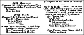
The primary materials used in this research are scanned historical directories and maps obtained from the Special Collections of the University of Hong Kong Library (HKUL), the Hong Kong Public Records Offices, and the National Archives at Kew, The United Kingdom. Auxiliary data, including streets from Google Maps and archived photographs from web sites dedicated to documenting historical Hong Kong, are used to supplement these data sets. The directories list public and private entities in historical Hong Kong such as wharfs and docks, shops, offices and warehouses, schools, churches and temples, and registered societies and associations. Each record typically contains the name of the entity in both Chinese and English, and may also contain information such as the entity's postal address, business nature, building name, and contact personnel, although such details are sporadically omitted (see Figure 1 for typical directory entries).Footnote 8
An example of the 1900 directory.Footnote 8

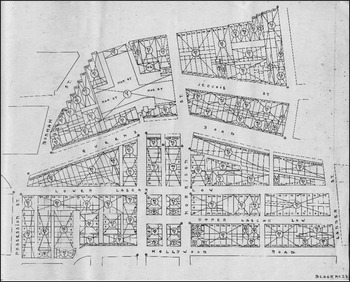
The maps, in contrast, portray the geographic landscape of the urban infrastructure, including the street network and parcel blocks around today's Central-to-Causeway-Bay region (Figure 2). In this study, “Hongkong block book”Footnote 9 (hereafter “block book”) provides the major source of these historical maps, which outline the boundary of parcel blocks, the primary building structure delineated by the street network, and their corresponding dwelling features. As illustrated in Figure 2, each intersecting cross indicates a parcel block with distinct construction features, such as foreign/Chinese occupancy, number of floors, and tile material. A parcel block can contain several parcel properties. The hollow space surrounding the parcel blocks and labeled by street names is a generalization of the street network. These maps in the block book are hard copy drawings, and are cataloged geographically into dozens of tiles. The maps demonstrated in this article only cover the urban areas of Hong Kong Island. Upon successful implementation, the next stage of this research will include Kowloon Peninsula.
Block 23 of the 1910 block book.

Methodology
The project's major steps include: 1) digitizing directories, 2) compiling street centerlines, 3) matching addresses to map locations, and 4) exploring spatial distribution and relationships.
The historical directories were first scanned into digital images (Figure 1). Optical character recognition (OCR) technique was used to extract selected text from the images. Unfortunately, the heterogeneous content and unstructured formatting yielded modest success and results failed the quality assurance/quality control (QA/QC) measures. Eventually, a manual data entry approach to compile the directories in spreadsheets was adopted.
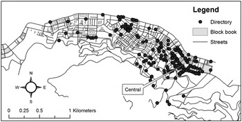
To map the geographic locations of urban entities based on their textual description (i.e., postal addresses) in the directories, it was necessary to reconstruct a street network of historical Hong Kong. Geocoding, more commonly known as address matching, refers to the process of assigning a geographic coordinate or location based on a description of that location in the form of, for example, (part of) an address or a place name. The street network map was compiled primarily from the scanned block book maps from HKUL. To minimize the effort of manually digitizing from scratch, a modern street network was acquired from Google Maps as the draft base map, and then modified in accordance with the historical maps from block books. Each tile of the block book maps was georeferenced, a process that transforms the coordinates of scanned images into real-world geographic coordinates. The centerline of the street network was traced and digitized as a map layer. The boundary of some buildings such as landmarks, public infrastructure, open markets, and recreational space was also digitized from the block book maps as polygons. Important attributes of the urban infrastructure, including street names, street numbers, street types, building names, and dwelling features, were entered into the attribute table of the corresponding features. The range of street numbers on both the left and right sides of the streets was recorded for each street segment for address matching purposes. The street centerline was then used to geocode the postal addresses of historical establishments from the directories and to mark their locations. In this study, a point layer portraying the spatial distribution of historical establishments was created for each decade of the 1900–40 period (Figure 3).
Historical establishments from a digitized directory and maps from a block book of 1910 Hong Kong. A label for the location of Central today is added for geographic reference.

Once the historical boundary data were in place and the relevant historical features had been geocoded, we explored how the legal changes in colonial Hong Kong over time had been systematically manifested in spatial patterns and further elucidated through GIS analysis. For example, the location of lawyers was queried from the directory to detect any spatial pattern. This process was repeated for different decades to examine if the general locations had shifted over time. The locations of lawyers in a given year were overlaid with another type of geographic features, such as commerce, to determine whether there was any spatial relationship between the two types of entity. This endeavor visualized and quantified how the spatial expansion of legal business was associated with the growth of commerce.
Geography of Legal History: Distribution of Lawyers as an Example
Lawyers began practicing English law in Hong Kong in the nineteenth century, well before the founding of the colony's Law Society in 1907. Unsurprisingly, most of the early practitioners were solicitors or barristers who came from Britain. Chinese, who studied law in England and returned to Hong Kong to practice, remained a minority until the latter half of the twentieth century.Footnote 10 Lawyers formed an important part of the English legal system in Hong Kong, and their spatial distribution is, therefore, one of the key areas of investigation in this historical GIS study. The following preliminary analysis and findings of the study represent a work in progress; however, they also serve as a useful illustration of how analysis via GIS can add to historical narratives of the law.
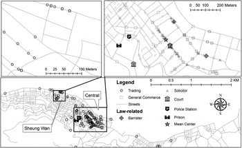
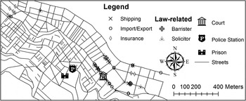
As shown in Figure 4, in 1910, solicitors' firms and barristers' chambers in Hong Kong were highly concentrated along Des Voeux Road and Queen's Road in the Victoria district (now known as Central). Victoria was (and Central still is) Hong Kong's core business area, home to commercial entities such as banks, merchants, insurance companies, shipping firms, hotels, and the trade operations of European businesspeople. The spatial distribution of lawyers changed little over the next decade according to the data collected for 1920. When the locations of lawyers' businesses are overlaid with those of commercial entities via GIS (see Figures 4 and 5), the close association between them reveals that the rise of the legal profession in early British Hong Kong cannot be separated from the development of commercial markets. However, the analysis shows that a handful of solicitors ran their businesses near an area west of Victoria/Central, which was predominantly populated by Chinese, and close to a police station, magistrates' court, and Victoria Goal (see Figure 4).
Spatial overlay of law-related businesses with general commerce and trading in 1910 Hong Kong.

Not only were law firms concentrated in commercial district of Central, but most of them were also located along the same 300 m on Queen's Road Central (see the zoom-in box on the top right corner of Figure 4 that highlights the 300 m portion of Queen’ Road Central). A closer look revealed that they were concentrated around major insurance and shipping companies, as well as import and export firms (see Figure 5). Such spatial association reveals a relationship between the business focus of the law firms at that time and Hong Kong's emerging role as an important entrepôt in the Far East during the early twentieth century.
Locations of insurance, shipping, and import-export firms with law-related businesses in 1910 Hong Kong.

These spatial patterns are very similar to the distribution of lawyers in early twentieth century Beijing and Shanghai when the Westernized legal profession was introduced to China as part of the large-scale legal transplantation. Previous studies reveal that the spatial distribution of Beijing lawyers in the 1910s to 1920s was closely related to the distribution of clansmen's houses (huiguan). These houses were meeting points for business migrants of the same native origin, as well as places where employers could recruit workers, conduct important business discussions, witness trade deals, reside during their stay in Beijing, and even resolve business disputes. As time passed, and as the legal profession expanded, the commercial and industrial centers of the city were no longer sufficient to sustain the legal community, and some lawyers sought other business opportunities by opening offices in the vicinity of police stations.Footnote 11 Chinese lawyers in Shanghai during the same period also remained highly concentrated in the urbanized and commercial areas between the foreign concessions and Chinese-controlled territories of the city, being absent from most of Shanghai.Footnote 12
The spatial dimension of the legal profession in the three cities reveals an important aspect of its development that typical archival sources, such as lawyers' memoirs and the minutes of bar association meetings, do not usually describe. The findings of the current project using GIS, although preliminary, pose a challenge to the readily accepted notion that the “professionalization” (by default, Westernization) of legal services accompanying the legal transplantation that occurred at the turn of the twentieth century brought ordinary Chinese people avenues to criminal justice that they would not otherwise have enjoyed. What the findings suggest instead is that the emerging legal practitioners in these urbanizing Chinese cities were more interested in serving commercial clients than in representing the masses.
Technical Challenges in Historical GIS Projects
A common challenge in historical GIS applications is the availability of suitable data, particularly spatial data about relevant features. For example, although street names are available from the maps in the block book, the general geometry of the street network is not shown (Figure 2). For geocoding purposes, the street geometry is typically represented as a line running through the center of a street (what has been referred to previously here as the “street centerline”) in GIS. In this research, the approximate loci of street centerlines were digitized manually from the scanned maps from the block book. Street numbers are available in the 1910 block book but not in the 1920 series. The lack of suitable data presents a major difficulty in base map development and maintenance over time.
Another challenge in base map development centers on data quality. Spatial data quality is of paramount concern in GIScience, as multiple types of errors in data,Footnote 13 such as measurement errors, positional errors, and incompleteness, may be introduced when gathering data, and errors will be carried over into subsequent steps in processing, modeling, and visualization.Footnote 14 In general, the more complex the geometry of the feature is (such as a road with curves or many turns), the more likely it is that errors will be introduced in capturing the feature in the data. If a postal address has no street number, a problem not uncommon in historical directories, an arbitrary street number will be assigned to give the feature an approximate location. Similarly, human errors, such as typographical errors, omissions, or displacements, were inevitable, and are found throughout the directories. In this research, considerable effort has been devoted to conducting QA/QC on the base maps and geocoded directories.
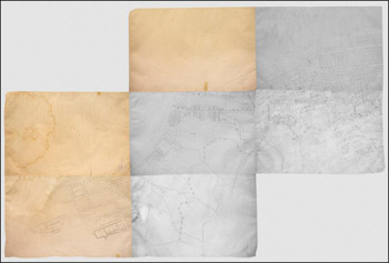
Many historical GIS studies rely on both spatial and tabular data in paper format, which requires an analog-to-digital conversion (ADC) to store data digitally. Although this operation can be automated through computer algorithms, such efforts are not always successful, as they depend upon both the conditions of archived data and the format of data content. The block book used in this project consists of fifty-eight map sheets, each of which is approximately 0.4m by 0.5m in size. Scanning and mosaicking require specialized hardware, such as a large-format scanner. Any wear and tear, wrinkles, or water marks on the map sheets distort the geometry and degrade the spatial data quality (Figure 6). For tabular data, most OCR algorithms are designed to detect and identify English. In this project, the mix of Chinese and English in the directory complicates the OCR task considerably. The variance in optional content across individual records (e.g., honorary member, business description), section headers, and special characters are scattered throughout the directory. Such structural variations in the directory have also caused errors and placed items in the wrong column (Figure 1).
Mosaicked imagery of the scanned block book.

In historical GIS studies, an obvious task in geocoding historical data is to reconcile temporal inconsistencies in the database. As the entire city in question slowly evolves over time, the urban infrastructure, including the street geometry and attributes (e.g., street names and numbers), also change. During the early colonial period in Hong Kong, for example, Praya was renamed Des Veoux Road. As a result, an establishment in the directory may have a different street name over time. Moreover, as major roads expanded in conjunction with urban sprawl, direction suffixes began to be used to differentiate different sections of the road. However, some postal addresses from the directory did not encode any direction suffix (e.g., “Queen's Road” instead of “Queen's Road West” or “Queen's Road Central”). The seemingly simple solution is to update the database by revising the corresponding records; however, many such modifications are trivial and labor intensive. Unfortunately, unlike the 1910 block book, the 1920 series stopped documenting street numbers in preference for lot numbers. Such inconsistency in data lineage further complicates database maintenance over time. In this research, the street numbers of the 1920 street map were updated based on the 1910 version.
These challenges are quite typical of historical GIS projects. Although not all humanistic projects will face the exact same challenges, they will likely follow the same process of extracting spatial information from hard copy documents, and storing it digitally as that described here. Although advances in information technology may improve the efficiency of data acquisition and processing methods, these challenges are likely to remain significant until all documents are stored digitally and much more effective methods for extracting or mining spatial information from them are developed.
Historical GIS: The Global Trend and Further Resources
GIS and its technology are more than five decades old. As history was one of the earliest humanities disciplines to leverage information technology and various forms of media in the new digital era,Footnote 15 it was also an early adopter of GIS, in both its system and science incarnations, in historical geography worldwide.Footnote 16 Methodological issues involved in historical studies,Footnote 17 and the impacts of GIS applications on historical geographyFootnote 18 have been discussed.
Many applications of GIS in historical studies were region specific. Examples include the Chinese Historical GIS (CHGIS) at Harvard University,Footnote 19 the Great British Historical GIS project,Footnote 20 and the National Historical GIS project in the United StatesFootnote 21 A project with a very strong international flavor is the Holocaust GIS.Footnote 22 Scholars and research institutes have established historical GIS in many countries. The resources page of the Historical GIS Research Network includes a list of these national systems (http://www.hgis.org.uk/resources.htm). The web site of the American Association of Geographers (AAG) also hosts a historical GIS clearinghouse and forum in which many historical and spatiotemporal data sources are included.Footnote 23 These resources are valuable for historical studies, particularly for those emphasizing the spatial dimension of events or history.
GIS also has been used in historical studies and historical geography at the city scale. For example, So and Wong reported the use of GIS to explore various dimensions of Republic Era Beijing from a spatial perspective.Footnote 24 Together with other scholars, dimensions they touched upon include industrial development,Footnote 25 public health,Footnote 26 legal services,Footnote 27 and civil movements.Footnote 28 Has GIS been widely adopted by humanity disciplines other than history, however? The title of Gregory and Geddes's 2014 edited volume Toward Spatial Humanities certainly gives the impression that humanity studies have been “spatialized,” but, unfortunately, its subtitle, Historical GIS and Spatial History, suggests that the spatialization remains limited to historical studies.Footnote 29 The edited volume published by Bodenhamer et al. (2010) demonstrates the promising potential of GIS in humanities; however, empirical humanity studies using GIS remain scarce.Footnote 30
Given that GIS is useful only if space is part of the researcher's concern, the likelihood of the humanities, beyond history, adopting GIS ultimately depends upon how the humanities and geography intersect. Ironically, space was valued in the humanities in the predisciplinary era, when Aristotle taught about the importance of place in every aspect of life, and platial geography was a fundamental concern.Footnote 31 The fracture between the two cultures of the humanities and the sciences may be the result of differences in “standards of evidence that practitioners deploy or are willing to accept.”Footnote 32 An organized effort to re-bridge the gaps between geography and the humanities was launched, resulting in at least two edited volumes on geohumanities.Footnote 33
The first issue of a new journal entitled GeoHumanities was published in September 2015, providing an (additional) outlet for scholarship at the intersection of the humanities and geography, including scholarship on the environment, creativity and performativity, language and communication, media and film, religion and belief, and landscape and architecture.Footnote 34 The re-convergence of geography and the humanities has been rebranded as “geohumanities.” Cresswell has called for the geohumanities to embrace the ability of digital humanitiesFootnote 35 and spatial technologies, including geocoding and geotagging functions,Footnote 36 to record, analyze, and represent space and time.Footnote 37
Investigating the spatial dimension of humanities is now recognized as a legitimate scholarly endeavor. However, the adoption of GIS as a tool to extend humanities scholarship beyond history remains quite limited despite such recognition. Although the project discussed here still falls under the broader discipline of historical studies, its spatial perspective on legal history expands the short list of empirical investigations in the geohumanities.
Conclusion
This article introduces and reflects upon the use of GIS as a tool, or GIScience as a research methodology, and associated techniques of analysis in an empirical study in progress on the law and history of British Hong Kong in the early twentieth century. We have demonstrated the general methodology of reconstructing the historical geography using GIS, and reported a number of preliminary observations on how the inclusion of a spatial dimension contributes to narrating the social history of law and legal systems. Organizing data in map form and overlaying different information layers permit spatial analysis that would be impossible through the study of archived text-form materials. More importantly, the map form of these visualized data can reveal correlations among variables over time.Footnote 38 With the continued expansion of the historical database using GIS, the next step of this project is to explore how changes in the distribution of the police force over the four decades of interest is correlated with the distribution of crimes, population increases, and the growth of industry and commerce. Such observable correlations will help inform the current discourse on the practice of the colonial legal system of early twentieth century Hong Kong.
Although intriguing, these observations are by no means conclusive without further elucidation through investigation of textual (and nonspatial) archival sources. The use of GIS in studying law and history cannot replace existing historiographical methods. Rather, it offers additional dimensions, both spatial and temporal, of quantitative analysis of historical data that may strengthen or challenge findings generated from qualitative analysis. It promises an integrative platform to generate new imaginings through empirical studies rather than suppressing existing approaches to the study of law and history. Realizing that promise demands not only appropriate computer hardware, software, and historical data sources, but also, more importantly, a firm determination to share information and collaborate with scholars of various disciplines and a passion to dive into a pool of knowledge beyond one's field of specialization. Such realization is not without challenges.
What is required is either interdisciplinary collaboration, or for humanities scholars to become knowledgeable and skillful in the use of GIS. Providing basic GIS training to humanities scholars is feasible, but is unlikely to be sufficient to equip them with the competence to use GIS effectively in their research. The most cost-effective and efficient strategy for exploiting the spatial dimension of humanities scholarship via GIS is for humanities scholars to team up with GI scientists. Although different modes of collaboration are possible, the most straightforward and logical approach is for the former to focus on conceptual formulations of the research, and for the latter to focus on extracting spatial information from the data and analyzing the data spatially. Of course, this marriage of researchers from two very different areas of scholarship will not be without difficulties. Humanities scholars not only need to appreciate, but also need to embrace, the additional spatial dimension; incorporate spatial thinking into their existing frameworks of inquiry; and accept a new standard of evidence from empirical-quantitative research.Footnote 39 At the same time, and reciprocally, GI scientists need to be more than technicians. They must be able to appreciate (and embrace) the spatiality of humanistic research, developing a keen sense of the need to sift spatial information from the textual, nonquantitative documents commonly used in such research. The resulting collaborative teams are likely to be a new force in knowledge creation by expanding the horizons of humanistic research and applicability of GIS across disciplinary boundaries.