INTRODUCTION
In the history of Mesoamerican studies, few topics have concerned archaeologists more than that of determining the social, political, and economic relationships that existed between regional and interregional cultures and polities. For archaeologists working in the Maya area, some of the most fundamental topics related to these issues concern questions regarding the Olmec “cultura madre” debate (Diehl Reference Diehl2004; Pool Reference Pool2009), the nature of Teotihuacan-Maya relationships (Braswell Reference Braswell2003), the connection between Chichen Itza and other western Mesoamerican sites such as Tula and El Cerrito (Cobos Reference Cobos, Mathews and Morrison2006; Kowalski and Kristan-Graham Reference Kowalski and Kristan-Graham2007; Nielsen et al. Reference Nielsen, Helmke and Fenoglio2013), and the waxing and waning of the political power and influence of Tikal and Calakmul (Martin and Grube Reference Martin and Grube2000), the two major Classic period Maya superpowers. Besides personal and professional biases that often influence some interpretations of these relationships, we would argue that quality and quantity of data available to a researcher represent the greatest obstacles for accurately determining the true nature of the affiliations and connections that existed between prehistoric communities. Indeed, limited data not only restrict our ability to make sound archaeological inferences, but also can negatively impact the accuracy of our interpretations and hypothetical reconstructions. This situation is particularly true for archaeologists trying to compare sites along modern Mesoamerican borders, a situation often compounded by access to information that is published only in one country or the other, by limited research at sites along insecure border zones, or by poor dialogue between researchers working at sites in these adjacent areas.
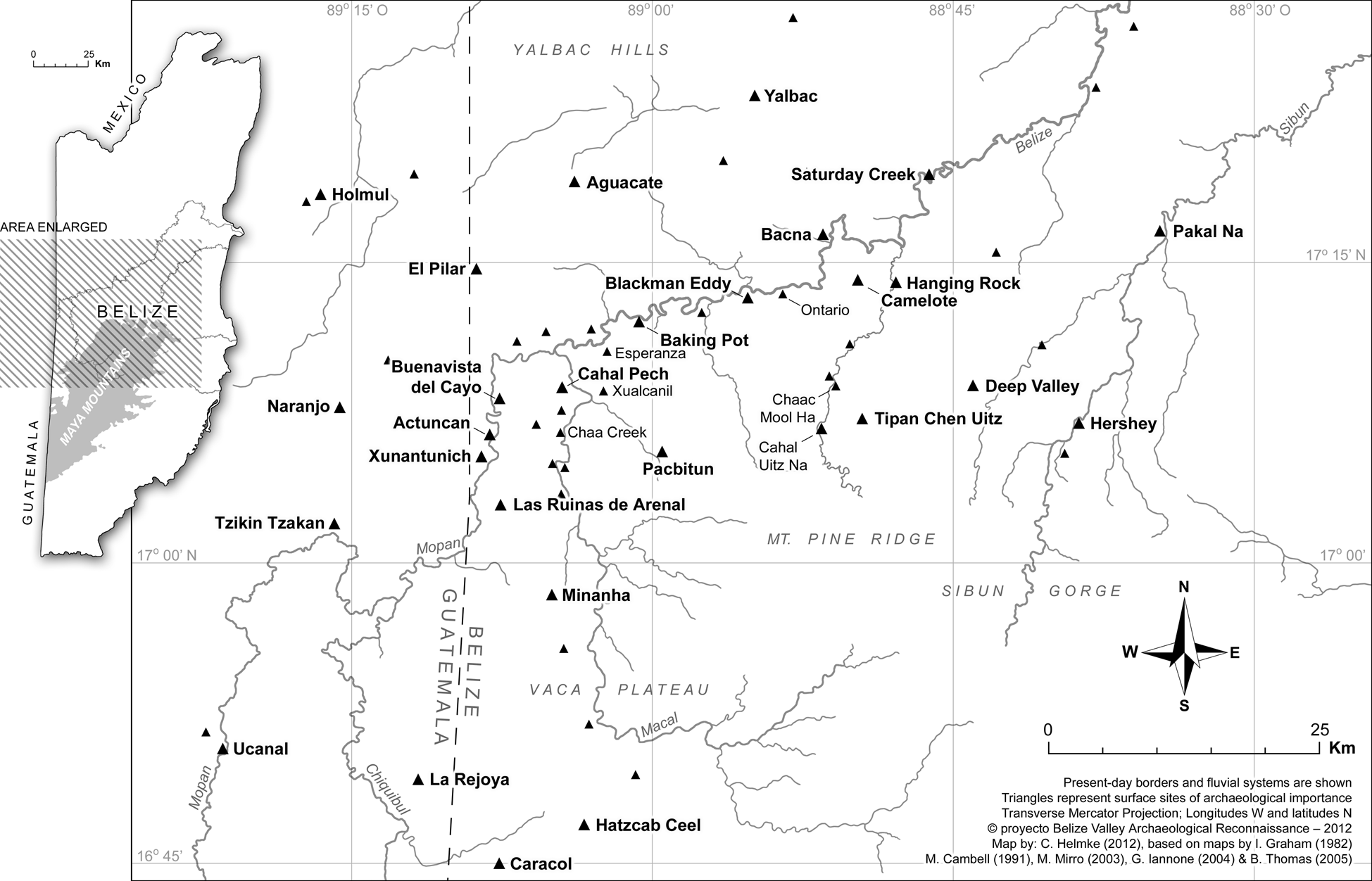
In the past, the latter considerations often hindered archaeologists working along the Belize-Guatemala border, especially those trying to investigate the dynamic powerplay that existed between Caracol and Naranjo, the relationship of these major sites with the Tikal and Calakmul superstates (Martin and Grube Reference Martin and Grube2000), and the effect that these power plays had on the Late Classic development of smaller centers such as those in the Belize River Valley subregion (Figure 1; Helmke and Awe Reference Helmke and Awe2012, Reference Helmke and Awe2018). It is this latter research question that we address in this paper. Our specific focus is to examine the relationship that existed between the major eastern Peten site of Naranjo and the medium-size Belize Valley center of Xunantunich.
Map of western Belize indicating location of sites referred to in the text. Map by Helmke after Helmke and Awe (Reference Helmke and Awe2012:Figure 2).

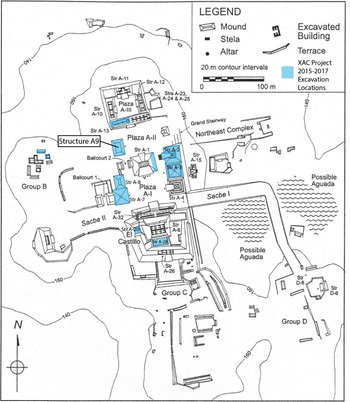
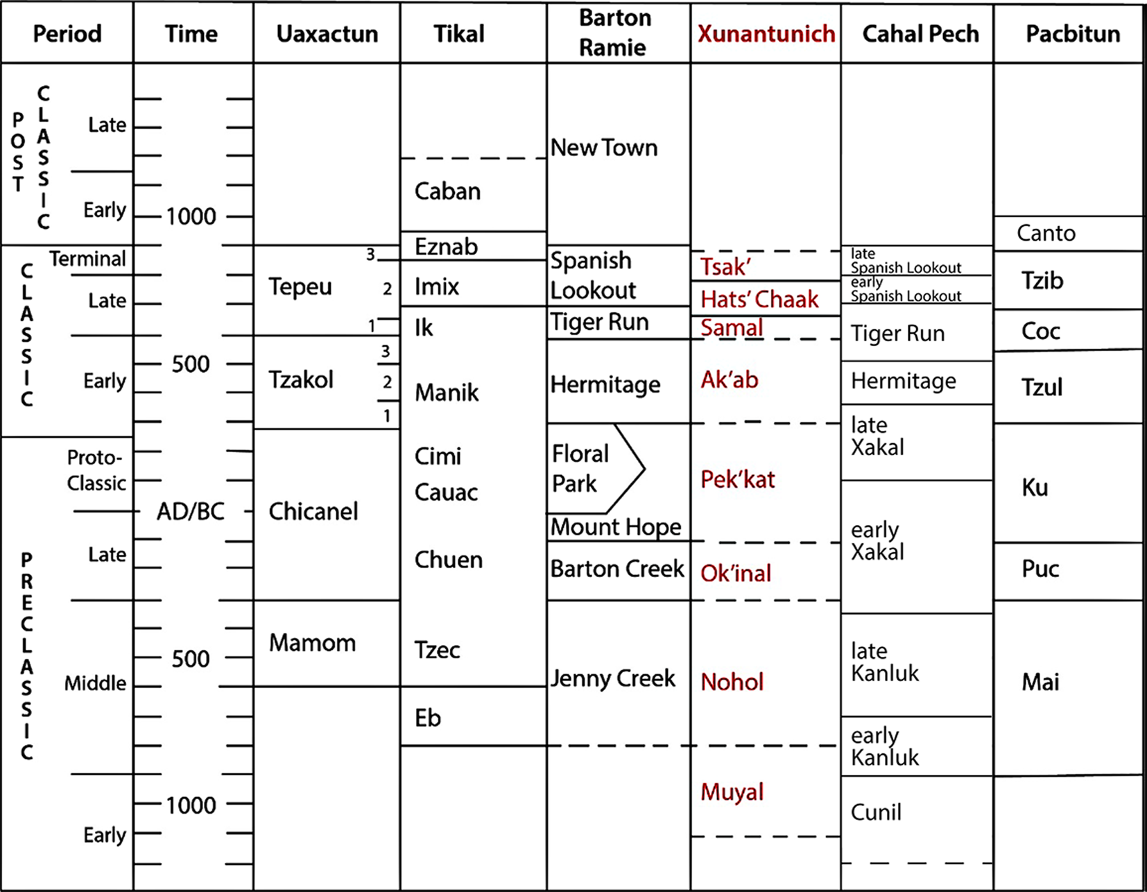
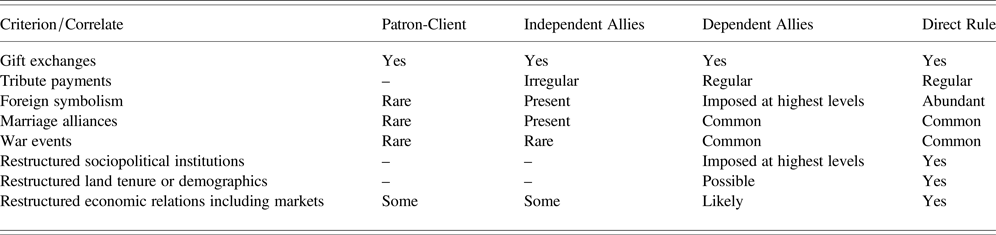
Based on considerably less data than are available today, it was previously hypothesized that Xunantunich (Figure 2) rose rapidly from a minor autonomous political center in the early part of the Late Classic (a.d. 600–670), to a powerful regional polity during the Late to Terminal Classic (a.d. 670–800) periods (Ashmore Reference Ashmore, LeCount and Yaeger2010; LeCount and Yaeger Reference LeCount, Yaeger, LeCount and Yaeger2010a; LeCount et al. Reference LeCount, Yaeger, Leventhal and Ashmore2002; Leventhal et al. Reference Leventhal, Ashmore, LeCount, Yaeger, LeCount and Yaeger2010). It was further suggested that Xunantunich's rapid rise and “changing political organization” was a direct result of its dynamic relationship with its more powerful neighbor to the west, the large city of Naranjo, and that close political ties between the two sites was partly the result of Naranjo's efforts to incorporate Xunantunich within its regional or territorial state (LeCount and Yaeger Reference LeCount, Yaeger, LeCount and Yaeger2010a, Reference LeCount, Yaeger, LeCount and Yaeger2010b), a process that began during Xunantunich's Late Classic Samal phase (a.d. 600–670), coalesced during the Hats’ Chaak phase (a.d. 670–780), and which was transformed during the Tsak’ phase (a.d. 780–890). This dynamic Naranjo-Xunantunich relationship, it was hypothesized, could be determined by examining the cultural remains associated with the three Late Classic phases of development at the site, and by comparing these cultural remains with archaeological correlates for various strategies of incorporation by Naranjo (Table 1). It was further hypothesized that, over time, Naranjo's strategies evolved from informal to more formal methods of incorporation, and that these formal or informal strategies differed primarily “in the degree to which the dominant polity,” Naranjo, controlled “the affairs of its subordinate,” Xunantunich (LeCount and Yaegar Reference LeCount, Yaeger, LeCount and Yaeger2010a:30). In the case of informal strategies of incorporation, which are typically associated with patron-client relations and independent alliances, participating members “rely on collaboration between the leaders of the dominant and subordinate polities, and although the subordinate polity remains independent, its leaders often depend politically on the more powerful partner for economic, military, and/or political support” (LeCount and Yaegar Reference LeCount, Yaeger, LeCount and Yaeger2010a:30–38). In contrast, formal modes of incorporation are generally associated with the annexation and/or direct control and rule of subordinate polities by their dominant overlords, or by situations where the subordinate polity is a dependent ally of the dominant polity (LeCount and Yaegar Reference LeCount, Yaeger, LeCount and Yaeger2010a:30–38).
Site map of Xunantunich (after Yaeger Reference Yaeger2005), showing location of structures recently excavated and conserved by the Xunantunich Archaeology and Conservation Project. Map courtesy of Jason Yaeger.

Ceramic chronology of Xunantunich and other central lowland Maya sites (after Leventhal et al. Reference Leventhal, Ashmore, LeCount, Yaeger, LeCount and Yaeger2010:Figure 1.4).

Archaeological correlates for incorporation strategies (after LeCount and Yaeger Reference LeCount, Yaeger, LeCount and Yaeger2010a:Table 2).

By identifying the presence or absence of certain cultural traits and remains (archaeological correlates; Table 1), we should, therefore, be able to determine Naranjo's different strategies for incorporating Xunantunich in its regional state, as well as the type of relationship that existed between the two sites over time. If the relationship between the two centers was an informal one, for example, it was suggested that we should find: (1) evidence of low-incidence gift exchanges between the two sites; (2) evidence that Xunantunich may have made irregular tribute payments to Naranjo; (3) that Naranjo's symbolism would be rare or present at Xunantunich; (4) that marriage alliances and war events were rare between the two sites; (5) that there should be no evidence of restructured sociopolitical institutions, land tenure or demographics at Xunantunich; and 6) that the latter's economic relations could have been reconstructed (LeCount and Yaeger Reference LeCount, Yaeger, LeCount and Yaeger2010a). If the relationship between the two sites was a more formal one, however, then we should find that, with the exception of gift exchanges, which are present in both scenarios, the correlates noted above should be essentially the opposite to what they were under an informal relationship between the two centers. Below, we review the three Late Classic phases of development at Xunantunich, and we examine the evidence previously used for determining the hypothesized Late Classic period relationship between Xunantunich and its more dominant neighbor Naranjo.
THE DYNAMIC DEVELOPMENT OF XUNANTUNICH DURING THE LATE CLASSIC PERIOD
Samal Phase a.d. 600–670
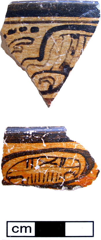
Both previous (Ashmore Reference Ashmore, LeCount and Yaeger2010; LeCount et al. Reference LeCount, Yaeger, Leventhal and Ashmore2002; Leventhal et al. Reference Leventhal, Ashmore, LeCount, Yaeger, LeCount and Yaeger2010), and current (Awe et al. Reference Awe, Helmke, Slocum and Tilden2019; Slocum Reference Slocum2018; Tilden et al. Reference Tilden, Slocum, Awe, Sullivan, Ebert, Burke, Hoggarth and Awe2017a, Reference Tilden, Awe, Slocum, Zanotto, Burke, McKeown, Jantz, Helmke, Can, Ebert, Burke, Hoggarth and Awe2017b; Zanotto and Awe Reference Zanotto, Awe, Ebert, Burke, Hoggarth and Awe2017) research at Xunantunich have confirmed that this Belize Valley site was established as a major center during the Late Classic Samal phase (a.d. 600–700). This period of development coincides with the last years of the influential and long rule of Aj Wosal Chan K'inich at Naranjo (Martin and Grube Reference Martin and Grube2000:71–72). According to LeCount and Yaeger (Reference LeCount, Yaeger, LeCount and Yaeger2010a:Figure 15.1), the relationship that existed between Naranjo and Xunantunich at this time was likely the result of an independent alliance between the two sites, or because of a patron-client relationship that was established by Naranjo in an effort to expand its regional control over the western Belize River Valley during this early facet of the Late Classic period. LeCount and Yaeger (Reference LeCount, Yaeger, LeCount and Yaeger2010a:40) report that this relationship is strongly suggested by the presence of Naranjo's emblem glyph on two fragments of polychrome pottery (Figure 4) that were discovered in construction fill in the Samal phase of the Castillo. They also note that “It remains to be determined whether the rulers of Xunantunich during the Samal phase were local elite who established a new political seat at a strategic locale, on the high, defensible ridge overlooking the Mopan Valley, or foreigners who inserted themselves into the upper Belize River valley's political landscape” (LeCount and Yaeger Reference LeCount, Yaeger, LeCount and Yaeger2010a:348).
Polychrome potsherds recovered in construction fill in the Castillo purportedly depicting Naranjo's emblem glyph. The Naranjo-style sherds actually record (a) part of the dedicatory verb t'abaay and (b) part of the nominal sequence chan. Photographs by Helmke.

In an effort to reassess the hypothesized Samal-phase relationship between the two sites, we decided to reexamine the polychrome sherds that were recovered in construction fill in the Castillo at Xunantunich (Figure 4). This new analysis was facilitated by LeCount, who graciously allowed us to photograph the sherds in her field laboratory in Belize. Results of our new study indicate that one sherd actually records part of a dedicatory verb, whereas the other preserves only the segment chan, “sky,” providing part of the name of the original owner of the vessel. Our more recent examination thereby confirmed that, although the style and palaeography of the glyphs on the Xunantunich potsherds are highly comparable to those produced in royal workshops in the Naranjo area, the glyphs do not record the emblem glyph of Naranjo. This evidence, however, does not preclude that these ceramics were originally produced at the Naranjo court during the reign of Aj Wosal and were traded or gifted to the ruling elite of Xunantunich, but at present, we should remain cautious as to this attribution.
In regards to the possible nonlocal origins of the Samal phase elite at Xunantunich, there is also recent evidence, albeit limited, that the Samal phase Xunantunich elite were local rather than “foreigners who inserted themselves into the upper Belize River valley's political landscape” (LeCount and Yaeger Reference LeCount, Yaeger, LeCount and Yaeger2010a:348). Excavations in Structure A4 at Xunantunich, for example, discovered one of the only known Samal phase crypts in the site-core. The burial, which was discovered in the southernmost pyramid of the site's Eastern Triadic Shrine or E-Group (Audet Reference Audet2006; Awe Reference Awe2008; Awe et al. Reference Awe, Hoggarth, Aimers, Freidel, Chase, Dowd and Murdock2017b), contained the remains of an adult elite male individual accompanied by several exotic grave goods, including fragments of two polychrome dishes with glyphs reminiscent of those that decorate Naranjo style vessels. The skeletal remains were placed in a prone and extended position with head to the south. As several researchers (Awe Reference Awe2013; Awe et al. Reference Awe, Ebert, Freiwald and Green2017a; Freiwald Reference Freiwald2011; Freiwald et al. Reference Freiwald, Yaeger, Awe, Piehl and Wrobel2014; Novotny et al. Reference Novotny, Awe, Santasilia and Knudson2018) working in the Belize Valley have noted, this burial orientation is standard for interments in the Belize River Valley, and represents a local tradition that extends from Middle Preclassic times to the Terminal Classic period. Strontium isotope analyses of skeletal remains in western Belize (Freiwald Reference Freiwald2011; Freiwald et al. Reference Freiwald, Yaeger, Awe, Piehl and Wrobel2014; Novotny et al. Reference Novotny, Awe, Santasilia and Knudson2018) also suggest that this burial orientation serves as a major diagnostic of graves containing the remains of local Belize Valley individuals. The local origins of the Structure A4 individual was further confirmed by strontium, carbon, and oxygen isotope analyses which indicated that the strontium values for the A4 burial were solidly within the range of Belize Valley skeletal populations (Freiwald et al. Reference Freiwald, Yaeger, Awe, Piehl and Wrobel2014). Given the results of these more recent investigations, we would argue that the local origins of Samal phase elites at Xunantunich, and the presence of ceramics bearing glyphs in a style typical of Naranjo are more consonant with the archaeological correlates that LeCount and Yaeger (Reference LeCount, Yaeger, LeCount and Yaeger2010a:Table 2.2) associate with patron-client or independent ally relationships. In both types of relationships, for example, one should find evidence for gift exchanges, and foreign symbolism should either be rare or present. The two ceramic vessel fragments in Samal construction fill in the Castillo, and those on the ceramic vessels in the Structure A4 grave are certainly indicative of the latter, and their presence also reflects a pattern that has been recorded at various sites in western Belize. Vessels originating at Naranjo, or with the latter's emblem glyph, for example, have been found at several sites in the Belize, Roaring Creek, and Sibun River Valleys (Helmke Reference Helmke2019; Helmke and Awe Reference Helmke and Awe2012:75–80), strongly reflecting Naranjo's efforts to establish its regional hegemony over this lowland Maya subregion during the Late Classic Samal phase (a.d. 600–700).
Naranjo's growing Late Classic influence in the Belize Valley was eventually arrested following its defeat by both Caracol and Calakmul in a.d. 626 and 631 respectively (Martin Reference Martin2005; Martin and Grube Reference Martin and Grube2008:72). The site subsequently experienced a hiatus that was to last for almost 50 years. Naranjo's fortunes eventually improved when, in a.d. 680, and under the rule of K'ahk’ Xiiw Chan Chaahk, it exacted revenge and dealt Caracol a significant defeat that silenced the latter for just over a century (Helmke and Awe Reference Helmke and Awe2018; Martin and Grube Reference Martin and Grube2008:95). The defeat of its regional rival also resulted with Naranjo's renaissance and a return to regional prominence (Helmke and Awe Reference Helmke and Awe2012, Reference Helmke and Awe2018; Martin Reference Martin2017).
Hats’ Chaak Phase: Early Facet (a.d. 670–740) and Late Facet (a.d. 740–780)
At Xunantunich, Naranjo's renewed rise in power coincides approximately with the first 70 years of the Hats’ Chaak phase. Under the regency of Lady Six Sky, and the rule of K'ahk’ Tiliiw Chan Chaahk, between roughly a.d. 682–741, Naranjo expanded its regional hegemony by reconquering lost territory, submitting neighbors to vassalage, by renewing relations with previous allies, and by establishing new relationships with other frontier capitals (Helmke Reference Helmke2017; Helmke and Savchenko Reference Helmke and Savchenko2016; Martin and Grube Reference Martin and Grube2008). In the case of Xunantunich, it was previously suggested that its relationship with Naranjo was transformed from its previous, Samal phase, patron-client or independent ally arrangement, to a more formal situation where it either became a dependent ally, or was directly ruled, or annexed, by Naranjo during the early facet of the Hats’ Chaak phase (LeCount and Yaeger Reference LeCount, Yaeger, LeCount and Yaeger2010a, Reference LeCount, Yaeger, LeCount and Yaeger2010b). It was also hypothesized that this transformation in the relationship between the two sites is indicated by: (1) the construction of the north palace complex in Plaza AIII of Xunantunich, (2) by rapid construction in the site's epicentre, (3) a new architectural layout at Xunantunich that is thought to emulate that of Naranjo's site-core, (4) the lack of a Hats’ Chaak phase royal throne in Xunantunich's site-core, (5) the lack of apparent high status objects at Xunantunich, and (6) a dearth of imported items in caches and burials. Below we examine each of these arguments in turn.
Xunantunich's North Palace Complex
In regards to the north palace complex, it was previously suggested that while pragmatic reasons such as overcrowding on the Castillo may have led to construction of the palace, it is more likely that the latter was constructed to house a new royal family that originated in Naranjo (Yaeger Reference Yaeger2005, Reference Yaeger, LeCount and Yaeger2010:147). On the basis of this observation, Yaeger (Reference Yaeger, LeCount and Yaeger2010:158) concluded:
[…] that Xunantunich was neither an independent ally of Naranjo nor an autonomous polity drawn in as Naranjo's client. Instead, the data from the palace suggest that Xunantunich's relationship with Naranjo early in the Hats’ Chaak phase entailed a greater degree of subordination. Xunantunich's early Hats’ Chaak rulers seem more likely to have been provincial governors or vassals of Naranjo, whether the ruling family's origins were local or foreign.
While these conclusions are both insightful and intriguing, particularly given the data available in the past, we would argue that recently recorded evidence more strongly supports the pragmatic reasons, such as overcrowding on the Castillo, for the construction of the north palace complex. Another alternative is that the construction of the new palace complex could more likely be associated with a shift in functions between the two loci of the site. Indeed, a comparison of palace complexes at sites in western Belize provides much stronger support for the latter inferences. Caracol, for example, has at least five palace complexes (Chase and Chase Reference Chase, Chase, Inomata and Houston2001), Baking Pot has at least two (Helmke et al. Reference Helmke, Ebert, Awe and Hoggarth2020), and even the slightly smaller site of Cahal Pech has three palace complexes in as many courtyards (Awe Reference Awe2008). If we assume that construction of new palace complexes was associated with the installation of new rulers, then we would also have to assume that the ruling lineages at most lowland Maya sites were constantly changing. This situation, however, is not supported by the hereditary data attested from sites with a large number of inscribed monuments (Martin and Grube Reference Martin and Grube2008). The number of palace complexes at a site, therefore, may not necessarily be linked to changes in ruling lineages, but correlate more closely with the increasing size of elite families, or with increasing administration, courtly prerogatives, and the individual motivations of particular monarchs.
Another concern with the rotating palace hypothesis is that it assumes that new foreign rulers at Xunantunich would have eschewed living in the traditional, more grandiose, seat of power (in this case the Castillo), for a much smaller, lower in elevation, and far less monumental residence (the north palace complex). Given the importance of symbolic power to the Maya, the use of monumental architecture as manifestations of power and prestige (Awe Reference Awe2008), and the fact that the Castillo was historically associated with the established seat of power at Xunantunich, the wholesale transferal of the royal palace from the Castillo to the north palace complex seems much less tenable. In our opinion, therefore, the addition of new palace complexes in site cores may simply reflect a need to house increasing numbers of elite family members during the Late Classic period, or the need for increased administrative space as a result of increasing sociopolitical complexity during this time.
Architectural layout of the Naranjo and Xunantunich site cores
As we noted in our discussion of developments during the Hats' Chaak phase, it was previously suggested that the architectural layout of Xunantunich at this time reflected an apparent and concerted effort by Xunantunich's elite to emulate the city of Naranjo. This suggestion, however, was made prior to the more recent investigations of Fialko (Reference Fialko and Shuster2012) at Naranjo, and by new excavations of Xunantunich's epicentral buildings, particularly those conducted on the eastern triadic temples, on the Castillo, and on Structures A7, A8, and A9 (Santasilia and Tilden Reference Santasilia, Tilden, Hoggarth and Awe2016; Tilden et al. Reference Tilden, Slocum, Awe, Sullivan, Ebert, Burke, Hoggarth and Awe2017a, Reference Tilden, Awe, Slocum, Zanotto, Burke, McKeown, Jantz, Helmke, Can, Ebert, Burke, Hoggarth and Awe2017b). The more recent investigations of the triadic temples, for example, demonstrate that, unlike Naranjo which has a typical, Uaxactun style, E-Group with a radial pyramid to the west, Xunantunich has an Eastern Triadic Shrine that is similar in style, configuration, and orientation to other Late Classic Eastern Triadic Shrines in the Belize River Valley (Awe et al. Reference Awe, Hoggarth, Aimers, Freidel, Chase, Dowd and Murdock2017b; Santasilia and Tilden Reference Santasilia, Tilden, Hoggarth and Awe2016). Unlike the Uaxactun style E-Groups, but very much like some Belize Valley Eastern Triadic Shrines, that of Xunantunich also does not have a radial pyramid to its west.
When we compare Naranjo's royal palace, the central acropolis, with Xunantunich's royal palace, the Castillo, there are also significant differences in the style, location, and orientation of the royal palace complexes at the two sites. At Naranjo, for example, the royal palace complex (Structures B14, B15, B16, and B17), is located to the west of its E-Group, while the Castillo at Xunantunich is located to the south of the Eastern Triadic Shrine (Awe Reference Awe2008; Fialko Reference Fialko2005, Reference Fialko2009; Tokovinine Reference Tokovinine2007; Tokovinine and Fialko Reference Tokovinine and Fialko2007). The Castillo at Xunantunich also shares closer architectural parallels with Caracol's royal palace, Caana, and with palaces recorded elsewhere in the Belize Valley. The 13 doorway audiencia at Caracol, for example, is located a third of the way up to the summit of Caana. At Xunantunich it is similarly located a third of the way up to the summit of the Castillo. Other audiencias in the Belize Valley, like that at Cahal Pech, also have 13 doorways, and all the audiencias in western Belize serve to demarcate public spaces from private elite spaces (Awe Reference Awe2008; Helmke Reference Helmke, Helmke and Awe2008). These features, particularly a 13-doorway audiencia on the ascent to the royal palace, are conspicuously absent in the Naranjo site-core, but quite evident at Caracol and sites in the Belize Valley.
Equally significant is the fact that the north groups of the two sites reflect differences, not similarities, in the spatial layout of the two centers. At Xunantunich, for example, the north group is represented by the four-building north palace complex described above. At Naranjo, the north group is represented by a massive architectural complex that is partly reminiscent of the Preclassic triadic temples typical of the northern Peten, with the addition of several other single and multi-roomed buildings on the southern and northeastern sections of the complex (Vilma Fialko, personal communication 2018; Tokovinine and Fialko Reference Tokovinine and Fialko2007:Figure 2).
Yet another difference in spatial layout can be noted in the orientation of the two site cores. Xunantunich has a marked north south orientation while Naranjo's is clearly east-west (Vilma Fialko, personal communication 2018). One of the few architectural similarities evident in the two site cores is the location of a large pyramidal building to the northwest of their eastern groups. At Xunantunich, this pyramid is labelled as Structure A1, and is located in front, or directly west, of the northernmost temple of the Eastern Triadic Shrine (Figure 2). At Naranjo, the structure is represented by Structure B19, and is located partly in front (or northwest) of the northernmost platform of the site's E-group. Despite this shared feature, when we take all the other architectural features at the two sites into consideration, it becomes abundantly clear that there are considerably more differences in the spatial layout and architectural styles at the two sites than similarities.
Lack of early Hats’ Chaak-phase royal throne at Xunantunich
In the Provincial Politics volume, Yaeger (Reference Yaeger, LeCount and Yaeger2010:154) previously suggested that the absence of thrones, defined as benches with the equivalent of armrests at either end of the bench, during early Hats’ Chaak times indicates that Xunantunich likely had no local resident ruler. This situation, he hypothesized, was a result of the fact that Xunantunich's “rulers were vassals subordinated to a more powerful polity” which in this case was Naranjo (Yaeger Reference Yaeger, LeCount and Yaeger2010:156). Not until the later facet of the Hats’ Chaak phase were the first thrones constructed at Xunantunich. Interestingly, however, these thrones, or benches with arm rests, were neither constructed in the Castillo, nor in the North Palace complex. Instead, they were built in Structure A15, a solitary, range-type building to the east of the site-core (MacKie Reference MacKie1985). It was also suggested that the construction of these thrones at the end of the Hats’ Chaak phase reflects a change in the relationship between Naranjo and Xunantunich, a change in which the latter polity began to exercise “a greater degree of political autonomy” than before (Yaeger Reference Yaeger, LeCount and Yaeger2010:156).
In our opinion, there are two concerns with this interpretation. First, we cannot assume that only benches with “armrests” were necessarily considered thrones by the Maya. As Yaeger (Reference Yaeger, LeCount and Yaeger2010:156) himself notes, “Maya thrones varied considerably across time and space in terms of their material, form, and decoration, unified perhaps only by the fact that kings sat upon them” (also see Harrison Reference Harrison, Inomata and Houston2001). In Maya art, depictions of rulers and/or elite individuals also show them sitting on benches with and without arm rests. Harrison (Reference Harrison, Inomata and Houston2001:78–79), in his study of Maya thrones, further noted that these architectural features are quite diverse across the Maya lowlands. At Tikal, for example, they tend to be simple, plain, and not very decorated. In comparison, those in the palaces of Usumacinta sites, such as Piedras Negras and Palenque, are considerably more elaborate (Harrison Reference Harrison, Inomata and Houston2001:78–79). Benches with arm rests, therefore, may simply reflect an architectural style that becomes more common in certain regions of the Maya lowlands during the end of the Late Classic period, rather than associated with the presence or absence of a local ruler.
Another feature that should be essentially considered is the fact some sites in western Belize, and the Maya lowlands in general, have several of these so-called thrones, while other sites have none. At less than 10 kilometers from Xunantunich, for example, Cahal Pech has at least four such thrones within palace buildings in four different courtyards, while none have been reported at Altun Ha or Lamanai. In the much less excavated site of Baking Pot, there are also two of these benches with arm rests in the Group B palace complex, while Buena Vista, six kilometecs from Xunantunich, has at least one example in its site-core (Helmke Reference Helmke, Helmke and Awe2008). Given the local and regional diversity in palace forms and benches, we would therefore argue that the presence or absence of benches with arm rests (thrones) likely has no correlation with the political status of a Classic-period Maya polity. This position concurs with that of Chase and Chase (Reference Chase, Chase, Inomata and Houston2001:103) who observe that even “the presence of a palace in and of itself does not imply the existence of a specific form of social political, or economic organization” for palaces, and we would add thrones, “as a kind of building, cut across a variety of political and economic forms.”
Lack of high-status imported items in caches and burials
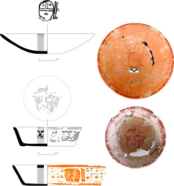
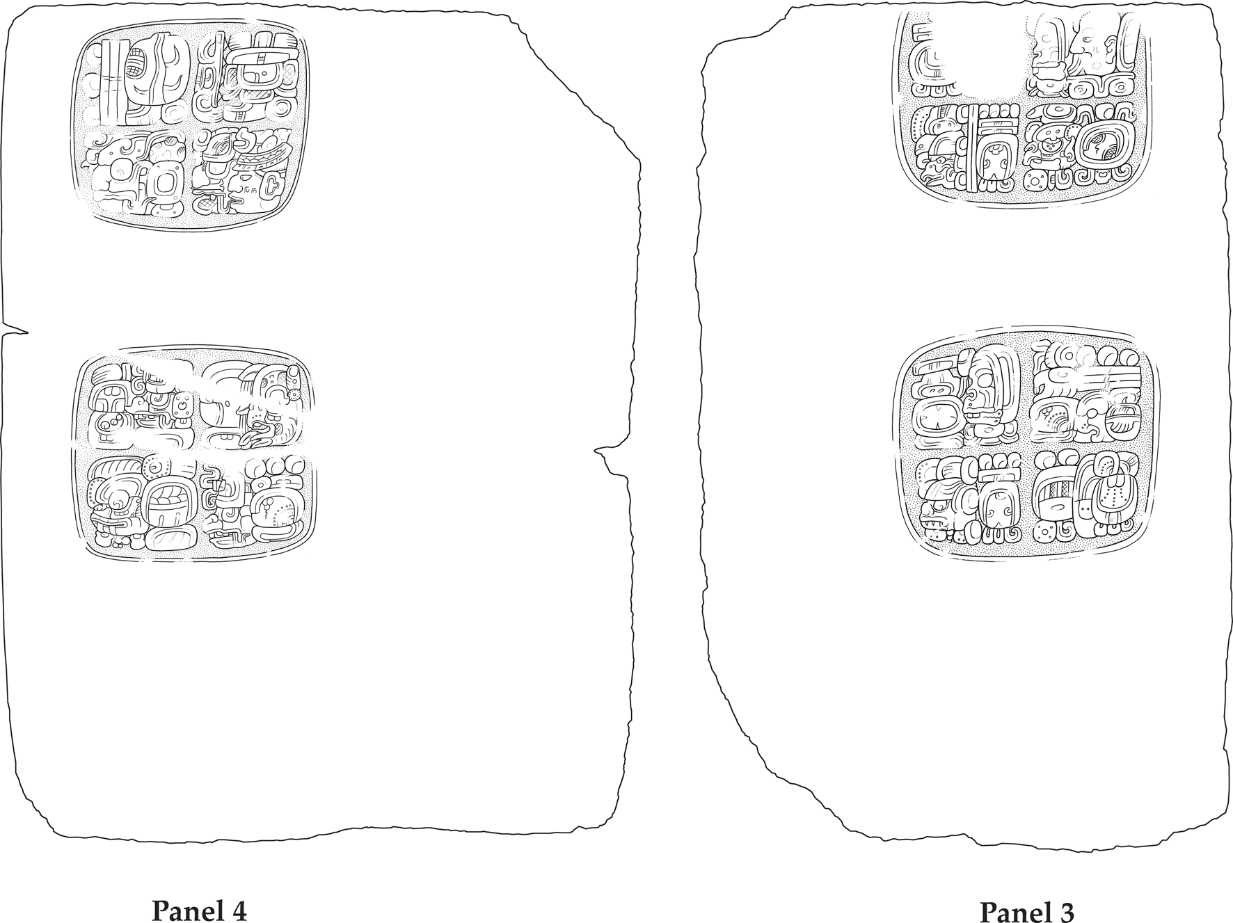
The last archaeological correlate previously employed as evidence for Naranjo's total subordination and formal control (direct rule) of Xunantunich is the lack of high status imported items in caches and burials at the site (LeCount and Yaeger Reference LeCount, Yaeger, LeCount and Yaeger2010a:35–39). Here again, more recent investigations in the Xunantunich site-core provide vital new evidence to the contrary. In the 2016 excavation of Structure A9, for example, investigators discovered two caches at the base of the pyramid (Sullivan Reference Sullivan2017), a large royal tomb beneath the structure's central stairway (Awe et al. Reference Awe, Helmke, Slocum and Tilden2019; Slocum Reference Slocum2018), and two inscribed panels (Panels 3 and 4) that are part of the Hieroglyphic Stairway that Maler (Reference Maler1908) discovered at Naranjo (Helmke and Awe Reference Helmke and Awe2016a, Reference Helmke and Awe2016b; Martin Reference Martin2017; Martin and Grube Reference Martin and Grube2008). One of the Structure A9 caches, discovered in an axial location at the base of the building, contained nine obsidian eccentrics, several marine and freshwater snails, fragments of pyrite and marine coral, and several other unidentified remains (Sullivan Reference Sullivan2017). The tomb contained 38 ceramic vessels, jadeite and marine shell jewellery, several obsidian bloodletters, plus several bones of deer and a large feline (Slocum Reference Slocum2018). Feline claw elements next to the body suggested that the individual in the tomb might have been wearing jaguar gloves akin to those depicted in several iconographic sources, such as the stelae of Seibal and Dos Pilas or the Altar de Sacrificios vase (Carrasco Vargas et al. Reference Carrasco Vargas, Boucher, González, Blos, Vierna, Moreno and Negrete1999; Colas Reference Colas, Helmke and Sachse2014; Slocum Reference Slocum2018). At least one of the vessels (Figure 5b) in the tomb, a Palmar Group polychrome, is decorated with a Naranjo style cormorant and pseudoglyphic text that share close parallels with similarly-shaped vessels produced during the reign of Naranjo's ruler K'ahk’ Xiiw Chan Chaahk. Accelerator mass spectrometry 14C dating of the human remains in the tomb produced a date of cal a.d. 660–775, and that of the deer bone yielded a date of cal a.d. 690–890 (Awe et al. Reference Awe, Helmke, Slocum and Tilden2019). Both of these dates confidently place the tomb and its contents in the early Hats’ Chaak phase. This temporal assignment is further supported by period-ending dates (a.d. 672 and 692) on two ceramic vessels (Figure 5a and Figure 6c) in the tomb that fall within the Hats’ Chaak phase (Awe et al. Reference Awe, Helmke, Slocum and Tilden2019; Helmke and Awe Reference Helmke and Awe2017).
A selection of glyph-bearing vessels from Burial A9-2. (a) Vessel 15 with period-ending date of 8 Ajaw. (b) Vessel 22a with Naranjo-style cormorant on the inside and pseudoglyphic text on the outer circumference. (c) Vessel 23a with period-ending date of 5 or 10 Ajaw. Drawings and photographs by Helmke.

Hieroglyphic Panels 3 and 4, which originally formed part of the hieroglyphic stair of K'an II, discovered on flanks of the central stairway of Structure A9 at Xunantunich. Drawings by Helmke.

In the case of the two inscribed panels (Figure 6), both Helmke and Awe (Reference Helmke and Awe2016a, Reference Helmke and Awe2016b) and Martin (Reference Martin2017) established that they are sections of the so-called Naranjo hieroglyphic stair that was originally dedicated at Caracol by K'an II to celebrate the auspicious period ending of a.d. 642. Almost four decades later, in a.d. 680, Naranjo's ruler, K'ahk’ Xiiw Chan Chaahk, exacted revenge on Caracol, then dismantled and displaced most of the blocks of the hieroglyphic stair to Naranjo where they were placed at the western base of Structure 18 in the site-core, but purposely reassembled out of order to make them illegible or out of syntax (Helmke and Awe Reference Helmke and Awe2016a, Reference Helmke and Awe2016b, Reference Helmke and Awe2018; Martin Reference Martin2017).
Interestingly, Panels 3 and 4 (Figure 6), the two largest sections of the hieroglyphic stairway, never made it to Naranjo. They were left at Xunantunich and were placed sideways and in reverse order on the flanks of the central stairway of Structure A9 (Awe et al. Reference Awe, Helmke, Slocum and Tilden2019). Another segment of the stairway was also previously discovered by Graham (Reference Graham1978:107, Reference Graham1980:153–154) at Ucanal (Martin Reference Martin2017). Following the discovery of Panels 3 and 4, Helmke and Awe (Reference Helmke and Awe2016a, Reference Helmke and Awe2016b) contemplated the factors that likely led to the presence of these large fragments of the hieroglyphic stairway at Xunantunich. One possible explanation was that the individual interred in Structure A9 had participated, as a member of Naranjo's royal court, in the war against Caracol, and that the two panels represented war booty shared with Xunantunich because of its participation in the battle. Alternatively, it was possible that the individual in the A9 tomb was a local lord of Xunantunich who acquired the panels as war booty through participation in the battle as an independent ally of Naranjo. Similar reasons, it was surmised, could also account for the fragment of the hieroglyphic stair found at Ucanal. To test the two hypotheses, fragments of the human remains from the tomb were submitted to both DNA and strontium isotope analyses. Research by Freiwald (Reference Freiwald2011; Freiwald et al. Reference Freiwald, Yaeger, Awe, Piehl and Wrobel2014) had previously established that the mean strontium values for Belize Valley populations was about 0.7086 with a range between 0.7082 and 0.7090. Results of the strontium analysis for the Structure A9 individual from Xunantunich yielded a value of 0.708386, a value that fits solidly within the strontium signature for Belize River Valley individuals (Awe et al. Reference Awe, Helmke, Slocum and Tilden2019). Particularly significant of this result is that it confirms that the A9 individual was local to the Belize River Valley subregion and not a person from the eastern Peten who was imposed on, or brought to govern, Xunantunich.
The DNA analysis also provided some very interesting results for it established that our assumed Lord of Xunantunich was actually a Lady of Xunantunich (Awe et al. Reference Awe, Helmke, Slocum and Tilden2019). While this result might lead some to question the suggestion that the hieroglyphic panels represent war booty given to the A9 tomb occupant because of their participation in the battle between Naranjo and Caracol, we would caution that military engagements and political affairs in ancient Maya society were not solely the domain of elite males. Both the hieroglyphic and archaeological records provide us with several examples to the contrary (Arden Reference Arden2002; Josserand Reference Josserand and Arden2002; Martin and Grube Reference Martin and Grube2008; Proskouriakoff Reference Proskouriakoff and Lothrop1961). Interestingly, one of the best examples of this situation is that of Lady Six Sky, “warrior queen” of Naranjo (Helmke Reference Helmke2017). Shortly after her arrival to Naranjo from Dos Pilas in a.d. 682, Lady Six Sky “assumed every…prerogative of kingship,” including “military symbolism” (Martin and Grube Reference Martin and Grube2008:74). As regent of Naranjo, she also successfully waged war with several of her neighbors. Later, during the first three years of her son's reign, she campaigned, nominally on behalf of him, against the locality of K'inichil Kab, as well as the cities of Tubal, Bital, Komkom, and even Tikal (Martin and Grube Reference Martin and Grube2008:76). Of greater significance to this study, however, is the fact that the hieroglyphic panels, the caches, and the contents of the tomb in Structure A9 are more representative of archaeological correlates for strategies of incorporation associated with patron-client arrangements or independent ally relationships (LeCount and Yaeger Reference LeCount, Yaeger, LeCount and Yaeger2010a:Table 2.2). These data, therefore, provide compelling new evidence suggesting that Xunantunich was not directly ruled or wholly dependent on Naranjo during the Hats’ Chaak phase, but that its rulers continued to enjoy a patron-client or independent ally relationship with Naranjo during this time.
Tsak’ Phase (a.d. 780–890)
In a.d. 744, towards the end of the Hats’ Chaak phase, Naranjo “was the target of a decisive assault at the hands of Tikal,” and its ruler Yax Mayuy Chan Chaahk was captured and sacrificed by the victors (Martin and Grube Reference Martin and Grube2008:78–79). LeCount and Yaeger (Reference LeCount, Yaeger, LeCount and Yaeger2010a) argue that with its benefactor weakened by the latter defeat, the Naranjo-Xunantunich relationship was severely affected and that this situation gradually led to Xunantunich's independence from Naranjo by the start of the Tsak’ phase. Archaeologically, this new-found freedom is manifested by “Xunantunich's rulers [placement of] greater emphasis on local symbols to maintain their identity and legitimize their status” (Jamison Reference Jamison, LeCount and Yaeger2010:144). Le Count and Yaeger (Reference LeCount, Yaeger, LeCount and Yaeger2010a) also suggested that Xunantunich's enhanced local status during the Tsak’ phase is best reflected by its dedication of three stelae (Stelae 1, 8, and 9), one altar (Altar 1), and one hieroglyphic panel (Panel 2), but especially by the texts recorded on Stela 8 and Panel 2 (Helmke et al. Reference Helmke, Awe, Grube, LeCount and Yaeger2010).
Xunantunich Stela 8 commemorates the period ending of a.d. 820, and the agent who is said to commemorate this event bears the Naranjo emblem glyph (Helmke et al. Reference Helmke, Awe, Grube, LeCount and Yaeger2010). The name is mostly eroded but based on what remains, and knowing that Waxaklajun Ubah K'awil, the current king of Naranjo, is known to have reigned between at least a.d. 814 and maybe until 830, he emerges as the most likely historical actor. Given the context and the reference made on Stela 8 at Xunantunich, it would also seem that Waxaklajun Ubah K'awil officiated the ritual “in person” at Xunantunich. Yet, the text on Stela 8 goes on to mention another actor, who is connected to him in a shared dance ritual that was celebrated on that date. This is likely the current ruler of Xunantunich given the emblem glyph that closes his titular section. As such, the references made to these individuals indicate close ties between their two courts, quite possibly a sign of allegiance in these troubled times. The text is mute, however, in terms of hierarchy, making it very difficult to determine whether one is best seen as an overlord and the other as a vassal. As such, it may well be that both are here referred to on equal footing as royal homologues, jointly performing rituals and celebrations of the propitious period ending. That Waxaklajun Ubah K'awil indeed celebrated this period ending is made clear by the mention made on Stela 32 at Naranjo, although there—not too surprisingly—no explicit mention to Xunantunich is made (Helmke et al. Reference Helmke, Awe, Grube, LeCount and Yaeger2010). The mention made at Xunantunich to this event suggests that Waxaklajun Ubah K'awil did not officiate this ritual at his own capital, but rather at Xunantunich, which is a telling sign of the continued relations between these two courts at the start of the ninth century. Grube and Martin's (Reference Grube, Martin and Grube2004:87) comment that Xunantunich Stela 8 “documents an interesting case of alliance building in the Terminal Classic period, probably in reaction to the enormous turmoil that was changing the political landscape of this time” provides further corroboration of the independent nature of the alliance between the two sites.
Given the evidence provided above, we agree with LeCount and Yaeger's (Reference LeCount, Yaeger, LeCount and Yaeger2010a) previous suggestion that Xunantunich was most likely an autonomous polity during the Tsak’ phase. At the same time, we would add that the text on Stela 8 also suggests that Xunantunich continued to maintain a close relationship with Naranjo, a relationship best understood under the rubrics of an independent ally or a patron-client arrangement. A similar relationship appears to have existed between Naranjo and several other Belize sites during the last century of the Late Classic period (a.d. 800–900). At Baking Pot, Buena Vista, Cahal Pech, Hershey, and several cave sites, for example, investigators have recovered several ceramic vessels bearing Naranjo's emblem glyph, or with texts that make reference to Naranjo and/or its ruler Waxaklajun Ubah K'awil (Helmke Reference Helmke2019; Helmke and Awe Reference Helmke and Awe2012; Helmke et al. Reference Helmke, Jobbová, Hoggarth, Ebert, Hoggarth and Awe2018). This active Terminal Classic gift giving by Naranjo likely represents a last-ditch effort to reestablish and extend its hegemony over the greater Belize Valley subregion at a time when most of the other primary lowland Maya centers were beginning to wane. The effort, however, was short-lived, for, not too long after, Naranjo itself began its rapid decline to obscurity.
DISCUSSION AND CONCLUSION
The purpose of this paper was to examine previous hypotheses concerning the relationship between the eastern Peten site of Naranjo with that of the Belize River Valley site of Xunantunich. As we noted in the introductory section of this article, previous researchers had suggested that this relationship was dynamic, evolving from an early Late Classic period Samal phase (a.d. 600–670) when the two sites were either independent allies, or were in a patron-client relationship with Naranjo as the dominant polity. It was further hypothesized that during the subsequent Hats’ Chaak phase (a.d. 670–780) this relationship was transformed, resulting with a more formal arrangement in which Xunantunich became annexed, directly ruled by a Naranjo elite, or wholly dependent on its more dominant neighbor. When in the Terminal Classic period Tzak’ phase (a.d. 780–890) Naranjo became weakened by military defeat at the hands of more powerful competitors, Xunantunich was able to gradually reassert its autonomy, but continued to maintain its relationship with Naranjo as an independent ally.
While the above assessment of the Naranjo-Xunantunich relationship by LeCount and Yaeger (Reference LeCount, Yaeger, LeCount and Yaeger2010a) represents a commendable early effort to determine the diachronic political connection between the two sites, our analysis of a larger and more recently acquired data base leads us to agree and to disagree with some of the details of their previously suggested hypothetical relationship between the centers. In the Samal phase (a.d. 600–670), for example, our new evidence certainly indicates that Naranjo may have enticed or coerced Xunantunich into a patron-client arrangement or independent alliance through the gifting of polychrome pottery and other exotics, and possibly by intermarriage, though there is presently no evidence to support the latter suggestion. As the archaeological correlates for incorporation strategies indicate (Table 1), marriage alliances are also not critical or significant in patron-client relationships, thus evidence for their absence during the Samal phase actually reinforces the argument for a patron-client relationship during the early part of the Late Classic period.
During the Hats’ Chaak phase (a.d. 670–780), the relationship between Naranjo and Xunantunich continued to grow but, in contrast to LeCount and Yaeger (Reference LeCount, Yaeger, LeCount and Yaeger2010a), we contend that this relationship never progressed beyond that of the earlier patron-client arrangement. Nothing bears this out more than the recent discoveries in Structure A9 at Xunantunich, which included caches of chert and obsidian eccentrics, a large tomb with sumptuous grave goods, the results of strontium isotope analysis of the individual in the tomb, and the presence of two large sections of the Caracol hieroglyphic stairway that we found flanking the central stairway of Structure A9 (Awe et al. Reference Awe, Helmke, Slocum and Tilden2019; Helmke and Awe Reference Helmke and Awe2016a, Reference Helmke and Awe2016b; Martin Reference Martin2017).
While the form and iconography on a few (10 percent) of the ceramics in the Structure A9 tomb display close affinities with material from Naranjo, more than 50 percent of the vessels belong to the locally diagnostic Belize Red ceramic group. The limited number of exotic Naranjo-like ceramics in the tomb likely represent gifts from Naranjo and thus is in keeping with the archaeological correlates for patron-client relationships. The two hieroglyphic panels discovered in front of Structure A9 at Xunantunich provide even greater support for an independent ally or patron-client relationship between the two sites. For example, the fact that the panels, which represent the two largest fragments of the Caracol hieroglyphic stairway, were retained or gifted to Xunantunich following the Naranjo-Caracol war clearly reflects Xunantunich's significant participation in the battle between the two larger centers. More significantly, however, is that if Xunantunich had been under the direct rule of Naranjo, it is very unlikely that it would have been allowed to keep the two largest fragments of the Caracol hieroglyphic stair. The fact that Xunantunich kept or was awarded these impressive monuments indicates that its significant participation in the conflict allowed them to claim or acquire part of the spoils of war, and this is certainly more closely aligned with the archaeological correlates for a patron-client or independent ally relationship with Naranjo.
During the Terminal Classic Tsak’ phase (a.d. 780–890), following the defeat of Naranjo in regional wars, the previous close relationship between the two sites apparently waned, leading Xunantunich to establish even greater autonomy from its more dominant patron. This change is best illustrated by the erection of several carved monuments at Xunantunich, and particularly by Stela 8, which refers to rulers from the two sites as equals or independent allies, rather than one representing an overlord and the other a subjugated vassal.
When we compare the dynamic development of Xunantunich with that of its local contemporaries, such as Baking Pot, Blackman Eddy, Buena Vista, Cahal Pech, and Pacbitun, we believe that present archaeological evidence strongly suggests that the social, political, and economic fortunes of upper Belize Valley sites both waxed and waned along with those of their competing patrons (Helmke and Awe Reference Helmke and Awe2012). In the case of Belize Valley sites, those competing patrons were Caracol to the south and Naranjo to the west. Prior to Naranjo's Late Classic period rise, for example, Belize Valley sites appear to have been under the influence of Caracol and Tikal. Evidence for patron-client relations with the latter sites is indicated by Pacbitun's Stela 9, which records the accession of its ruler possibly under the aegis of Tikal (Helmke Reference Helmke2019:34; Helmke et al. Reference Helmke, Grube, Awe and Healy2006), by the presence of Caracol's emblem glyph and Caracol-like regnal names on pottery at Baking Pot (Colas et al. Reference Colas, Helmke, Awe and Powis2002; Helmke and Awe Reference Helmke and Awe2008:85–86; Helmke et al. Reference Helmke, Hoggarth and Awe2018), by Caracol-style finger caches at Baking Pot and Cahal Pech (Awe and Helmke Reference Awe and Helmke2005:44; Helmke Reference Helmke2019:35; Helmke and Awe Reference Helmke and Awe2012:80–81), and by a Caracol-style multiple burial in the eastern shrine at Cahal Pech (Awe and Zender Reference Awe and Zender2016; Novotny et al. Reference Novotny, Awe, Santasilia and Knudson2018).
The picture that clearly develops from these archaeological data is one that depicts Belize Valley sites caught in a historical and perennial “tug-of-war between Naranjo and Caracol” (Helmke Reference Helmke2019:35). It is apparent, therefore, that Belize Valley rulers had to learn how to astutely balance their independence with the demands and political ambitions of the more powerful states on both sides of the modern Belize-Guatemala border. In the end, their social, political, and economic survival truly depended on how well they were able to adjust, collaborate, and thrive within the shadow and political interests of their larger, more competitive, and more dominant regional neighbors.
RESUMEN
Investigaciones en Xunantunich indican que este importante sitio del Valle del Río Belice alcanzó rápidamente a prominencia regional durante la fase Hats’ Chaak del periodo clásico tardío (670–780 d.C.). Aunque las razones sociales, políticas y económicas del aumento relativamente tardío y rápido de Xunantunich aún no se entienden completamente, se ha sugerido que este ascenso fue el resultado directo de una relación patron-cliente con, o debido al control directo por, el centro primario más grande de Naranjo en Guatemala. En este artículo evaluamos argumentos propuestos anteriormente acerca de esta relación dinámica entre los dos sitios, y discutimos las implicaciones políticas de los datos adquiridos más recientemente en nuestra evaluación de esta relación.