

INTRODUCTION
Towers were once a ubiquitous feature of the medieval landscape in the eastern Mediterranean, but for the most part their builders and dates of construction are unknown. There has also been a long debate as to their role, with early researchers (Bon Reference Bon1937; Koder Reference Koder1973) suggesting a communicative function, whilst more recent contributions have proposed that they were introduced by the Franks after the Fourth Crusade. The purpose of this paper is to appraise the evidence for the use of communication beacons in the medieval period within the eastern Mediterranean, to analyse their practical efficacy using modern scientifically based data sets, and to apply this to the corpus of towers in Central Greece.
The conclusions reached are based primarily on a reconstruction of the medieval landscape of Euboea (a large island just off the eastern seaboard of continental Greece) undertaken over the last 10 years by the author. Following an explanation of the methodology used for this and a short review of the literature, there follows a discussion of the parameters of visibility, signalling methods and operational challenges involved in communication networks.
An important discovery has been the identification of a new term – the pyrgari – which appears to refer to a small circular tower used exclusively for observation and as a beacon. This is discussed in detail and then integrated together with the general corpus of towers on Euboea and in Central Greece to identify four possible long-distance communication chains. The paper concludes by proposing a theoretical framework for the tower based on its role in communication – something that allows us to reconcile the functions of defence and display and consider another dimension by which regions are connected and bound together.
THE EXISTING LITERATURE
There is a famous story that the Byzantine emperor Michael III (r. 842–67) frivolously terminated the long-distance communication system which had been constructed by his father Theophilos (r. 829–42) to provide early warning of Arab attacks on the south-eastern border of Anatolia. This is recorded in six separate sources and, whilst there are doubts about the veracity of the story, there does not appear any reason why they should lie about the existence of the network itself.Footnote 1 This chain of nine beacons, which stretched from Loulon in south-eastern Anatolia a distance of about 700 km to Constantinople (an average inter-nodal distance of over 85 km), is the only Byzantine communication chain on which we have any documentary details and has been much mentioned in the literature. Most studies, however, even the very detailed analysis by Pattenden (Reference Pattenden1983),Footnote 2 have not gone beyond its theoretical capability to look at how reliable it was as a system and how easy it was to send either a new signal or cancel the original one – its ‘repeatability’.Footnote 3
In Central Greece, Rife (Reference Rife, Caraher, Jones-Hall and Moore2008), basing his argument on an inscription found in the Peloponnese during its occupation by the Venetians (1688–1715) and a suggestion by Bon (Reference Bon1951, 52), has argued that the tower that once sat atop the fortifications at Acrocorinth was part of a chain of beacons linking the regions of the Peloponnese to Corinth. The original location of the inscription and its dating are unknown. It is written in Greek on a block of ‘pale, fine-grained limestone’, and its lettering form appears to be similar to that of the Middle Byzantine period. Rife translates it as ‘Lord Leo erected here a tower to send signal by lamp of bands of barbarians’. Following other commentators, he hypothesises that amongst the possible candidates the ‘Lord Leo’ mentioned in the inscription was probably Leo VI (886–912), that the network was to announce attacks by seaborne Arabs (they controlled Crete from the 820s until 963), and that the tower provided the ability to see up to 80 km away in clear weather. On this last point he may be correct, but what about the rest of the year when low cloud, snow, rain, summer haze, and dust borne by the early autumn meltemi winds restricted visibility? Both he and Pattenden fail to address the fact that any Arab attack, whether by land or sea, was likely to be launched precisely when visibility was poor, and the design of any early warning system must have been undertaken with this in mind.
Commentaries on both these networks have assumed that, with some caveats for coastal humidity,Footnote 4 an inter-nodal distance of 80 km is a practical configuration, yet evidence from elsewhere suggests that this is not the case. Recent archaeological research by Modeo and Cutaia (Reference Modeo, Cutaia, Congiu, Modeo and Arnone2010) has identified beacons on hilltop locations along the coast of south-western Sicily, in use from the seventh to the ninth centuries by the Byzantines (and also later utilised by the Arabs and Normans), the nodes of which were a maximum of 25 km apart. On Chios in the fourteenth century, the Genoese Mahona company constructed a sophisticated defensive umbrella of watchtowers to protect their mastic monopoly, yet none of these was more than 6 km apart.Footnote 5 Chains of watchtowers and forts in the south-eastern Peloponnese stretching from the Venetian fortress of Corone northwards and west towards that at Methone (Modon) have a maximum 11 km distance between beacons. Pattenden (Reference Pattenden1983) cites the Arab geographer, Al-Muqaddasi (c. 985), writing on a chain of towers in Palestine to warn of Greek galleys approaching the coast close to Ar-Ramlah, the capital. We do not know how many towers were in the chain, but the distance is only about 60 km, suggesting that four towers with a maximum internodal distance of 15 km could alert the city. We can also look at a later network for comparison: in Elizabethan England beacons set up along the south coast of England were located about 18 km apart.Footnote 6
These five chains, for which we have documentary evidence of their practical use and/or archaeological sites which record exact locations, possessed beacons with an inter-nodal distance less than a third of the Byzantine networks proposed for Anatolia and the Peloponnese. This, coupled with issues surrounding network reliability and repeatability noted above, provides a prima facie case for questioning our current interpretation of the evidence for the latter.
THE PARAMETERS OF VISIBILITY
Networks need to be divided into two types. The first are ‘strategic’ in nature. They are to provide early warning from a long distance to a central administration point for measured action. As a result, their organisation and the message they send is likely to be complex. At the other extreme is the ‘tactical’ network, such as the fourteenth-century Genoese one on Chios where inter-nodal distances are as little as 1.5 km. This was organised to provide a tight defensive cordon and an immediate, probably simple, warning or alarm for urgent action.
Owing to the distances involved, each type of network requires a different type of signal: at short distances a simple flag or torch (or later a gunshot) would have been sufficient.Footnote 7 But for the longer ranges a massive smoke cloud or fire would have been needed. The latter present a logistical challenge since to generate a single fire 10 m in diameter and height requires over 200 m3 of combustible material. The Elizabethan network was re-enacted in 1977 with bonfires of 9 m diameter and height, each requiring more than 30 tons of combustible material (Pattenden Reference Pattenden1983).
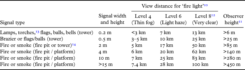
As size increases, the type of installation also changes. Table 1 indicates the minimum signal size and height required depending on the inter-nodal distance, although the signal would probably normally have been relatively much larger when nodes were close. Using the ‘Luminous Range Diagram’ from the ‘Standardization of List of Lights and Fog Signals’ developed for modern lighthouses, it provides view distance in varying weather conditions (these range from level 1 for dense fog to level 9 for exceptionally clear).Footnote 8 It becomes immediately obvious that for most areas around Greece and the Aegean, even in good summer weather conditions (level 6), visibility is restricted to less than 30 km.
Indicative beacon visibility distances and signal size.

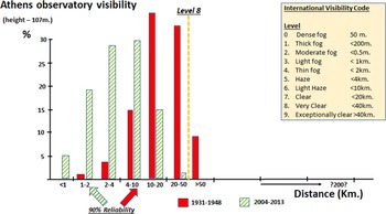
Recently, Founda et al. (Reference Founda, Kazadisz, Mihaolopoulos, Gerasopoulos, Lianou and Raptis2016) have produced an analysis of actual visibility throughout the year at the National Observatory, Athens, over the last 80 years. Two series of figures – for the periods 2004–15 and 1931–48 – are shown in Fig. 1.Footnote 9 Athens is a special case in that it is surrounded by mountains, and not only is the viewshed from the National Observatory (set at 107 m height) relatively restricted, but atmospheric pollution also substantially reduces visibility. Two factors are significant, however, and provide the basis for the measurements to be utilised in the present study. The first is the sharp deterioration of visibility between the 1930s and today, suggesting that the former figures may reflect more closely the situation that existed in earlier periods; the second is that for both periods the shape of the curve formed is close to a normal (Gaussian) distribution, a feature we can use to extrapolate to more arid upland regions.
Percentage of year for various visibility distances in Athens.

One conclusion that can immediately be drawn from the data is that any designer of a communications system around the littoral regions of the Aegean, who wished to ensure a 90 per cent reliability for the system (i.e. that it would function satisfactorily for 329 days a year), even assuming that visibility is substantially better than Athens, would have had to specify a maximum of 20 km between the nodes of the system for all-year round functioning. If planning for operation excluding the winter months, assuming a greater than level 7 (clear) visibility, this might extend even to 40 km but not beyond. It should also be noted that, as the length of the chain extended, there would be a commensurate reduction in reliability as the possibility of weather patterns differing between beacon sites increased: it was only necessary for one beacon to fail for the whole system to break down.
Using this as a base we can now study the beacon network proposed by Rife (Reference Rife, Caraher, Jones-Hall and Moore2008) and Bon (Reference Bon1937) around Acrocorinth. Rife's contention of a possible viewshed extending to 80 km is immediately suspect given its coastal location, which precludes inter-beacon distances greater than 40 km. More importantly, however, the data in Table 1 suggest that a brazier set on the tower could have been seen only in level 8 (very clear) weather up to 50 km, whilst in level 6 (light haze), normal summer visibility, it would be restricted to a 17 km viewshed. The conclusion must be that, unless the tower was only used to raise a local alarm, the actual beacon fire was lit on a platform within the fortress, which itself stands to a substantial height. Under this scenario the view distance probably mirrored the 25 km found in Byzantine Sicily noted above.
THE BYZANTINE CHAIN IN ANATOLIA
Turning now to the ‘strategic’ Byzantine network in Anatolia,Footnote 15 Pattenden (Reference Pattenden1983) records its approximate length as 700 km (about 450 m) with 9 nodes, and that the largest internodal distance was 150 km.Footnote 16 This is theoretically possible but, when considering the needs of reliability and repeatability discussed above, appears operationally impractical. In addition, during the day we must consider two other issues: firstly, that of contrast – in simple terms, to identify smoke from a fire against a backdrop of heavy cloud is nearly impossible. Secondly, the angle of the sun plays an important part in distinguishing features at a long distance meaning that visibility is constantly changing throughout the hours of daylight (Malm Reference Malm2016, fig. 1:23,29).
We can presume, as did Aschoff, that Leo's network is mere legend, yet the sources had no incentive to invent its existence. Constantine Porphyrogenitus, for instance, was writing a practical text to teach his son, and explains to him ‘how, through certain beacons and torches lit before in succession, the emperor, within one hour, learns immediately of the enemy's attack’.Footnote 17 We may, however, be treating the written evidence too literally. The contemporary accounts are quite specific, noting that the signal was passed from one named beacon to the next named beacon,Footnote 18 but this could merely be the interpretation of the various chronicles which, Pattenden suggests, may have drawn upon a common source, or even that of the source itself.
Until relatively recently travellers navigated by simply asking the way, as the well-known Greek proverb notes “Ρωτώντας πας στην πόλη” (asking you go to the city).Footnote 19 At the beginning of a car journey, even today, the general waypoints used are relatively close to each other until the highway is reached. The further away they are from your starting point, the farther apart the landmarks are likely to be until you are nearing your destination, at which point any directions are likely to be detailed and points of reference very close together. This is exactly what we find with the Anatolia beacon chain: the first five nodes from Constantinople average just over 40 km apart, the fifth to eighth nearly 150 km, whilst from the eighth to Loulon on the south-eastern border with Arab controlled areas the distance is about 60 km.Footnote 20 If this is correct, then the original intention of the writer who described the network may have been to say ‘towards’ rather than ‘to’ or ‘from the direction of’, intimating that a number of intervening beacons have been omitted.
Immediately, the network becomes logistically functional, allowing, given the region's height and the relatively long view distance prevailing there,Footnote 21 good inter-visibility between beacon points for a substantial period of the year, whilst keeping the cost of maintenance relatively low since the size of beacons is now within manageable proportions.Footnote 22 This, however, is difficult to reconcile with the claim by Constantine Porphyrogenitus that the message was transmitted over this distance ‘in one hour’.Footnote 23 Theoretically this is possible, as the 1977 Elizabethan re-enactment demonstrated: the Queen lit the first beacon at 22.06 and the signal arrived in Shetland at 23.00, a distance of over 1000 km. The beacons, however, were pre-arranged to be ignited at three-minute intervals so there is the probability that actual response rates would have been much slower and quite possibly in inclement weather impossible. Since timing was critical – the message differed according to the time of day sent – just this would have made it unreliable.Footnote 24 Thus, Michael III's termination of the system, despite criticism by later commentators, may have been because, in practice, the network simply did not work as planned!
Aschoff (Reference Aschoff1980), whilst not believing the existence and operation of the chain of beacons as described in the sources, suggests that it may have grown out of a local relay network. Both the inscription found in the Peloponnese quoted by Rife (Reference Rife, Caraher, Jones-Hall and Moore2008) and the archaeological evidence from Sicily suggest this may be correct. There also appears to be further evidence of communication chains from Central Greece: Koder and Hild (Reference Koder and Hild1976, 112–13) have proposed the existence of a chain of towers along the Kifissos River in Boeotia to Thebes,Footnote 25 and Johannes Koder (Reference Koder1972) has suggested another linking western Euboea to the Aegean.
Lock (Reference Lock, Lock and Sanders1996) disputed this, citing the general lack of inter-visibility of the surviving towers. His argument fails on three counts. First, as seen with the situation at Acrocorinth, a tower is not necessary on a hill to forward a message: a simple platform is quite sufficient, although within a valley or plain it is essential for rising above surrounding woodland and buildings. Secondly, he has not considered that many beacon points may have been constructed of wood (see below), and thus no archaeological record has survived of their existence.Footnote 26 Thirdly, if the network is for long-distance communication, then, as noted in Table 1, a tower is insufficiently large for the size of fire required, and in such cases, as in Sicily, fire-pits were constructed on the peaks of strategic hills.
CONSTRUCTION OF THE CARTOGRAPHIC MODEL
In order to check tower intervisibility a topographic model utilising GIS was constructed of medieval Euboea with the inclusion of some data from Central Greece (Blackler Reference Blackler2020, 535–41). The island, whose capital Chalkida was known as Egrippos, later Negroponte, in the medieval period, lies off the eastern seaboard of continental Greece, yet is so close (at one point only 30 metres) that it has been considered administratively as part of the mainland even up to the present day. It is also the first island in a series (Andros–Tinos–Mykonos–Naxos) that stretch down into the central Aegean.Footnote 27
The many articles and books written by local Greek historians together with the doctoral thesis of Johannes Koder (Reference Koder1972), a study of the island in the medieval period, have provided the foundations for the model.Footnote 28 Following the work of medieval archaeologists in the British Isles (e.g. Jones Reference Jones, Arnau and Reynolds2015) and recognising that the archaeological footprint of many towers (both of stone and wood) has now been lost, other probable tower sites were added, which had been identified only by their placename.Footnote 29 For this purpose, over 200 maps dating from the fourteenth to the twentieth centuries were utilised.Footnote 30 These were geo-corrected and overlaid onto the basic GIS model with elevation data to provide a three dimensional map.Footnote 31 The tower sites were then incorporated into this landscape model together with probable settlements and other monuments (fortifications, monasteries, churches, aqueducts, roads). Those with well-preserved remains were visited but most were checked using satellite imagery available from Google Earth or ArcGIS.Footnote 32
The result was surprising: in addition to the 77 noted in the literature, 57 new tower sites were found on the island alone. Many towers may also still remain unidentified, since the density of towers in some regions was found to be greater (e.g. in the Lelantine plain east of Chalkida) owing to the better availability of historical cartographic sources there. Most placenames were variations on the Greek for tower, “πύργος” (pyrgos), but also included Latin (vigla = watchtower), Italian (ture/touretta) and Frankish (tourli = tourelle in modern French) references.Footnote 33 Having established their position, a study was then undertaken of the intervisibility between sites using ArcGIS software.Footnote 34
An important conclusion reached was that all sites had visibility to at least one other tower or fortification. There also emerged what appeared to be core chains of beacons running down the western coast and the mountainous spine of the island. At this point the usefulness of including all known medieval monuments into the model was appreciated. Certain towers had clearly been built over during the nineteenth century and gaps were apparent in certain chains: by checking the viewshed overlap between two contiguous towers, studying elevation data and linking to a church, monastery or settlement, the probable position of these ‘lost’ towers could be surmised.
THE PYRGARI
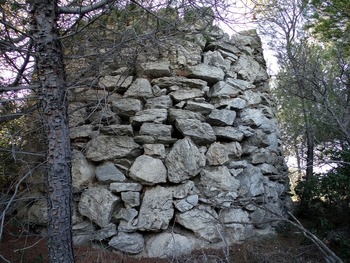
Langdon (Reference Langdon1995) noted two medieval towers on the eastern coast of Attica opposite Euboea with the name Pyrgari (πυργάρι).Footnote 35 They measure 3.79 m and 5.2 m in diameter (0.85 m thick walls) and were probably about two storeys high originally, possibly with an entrance raised slightly above ground level (Fig. 2). They are constructed of rough-cut stones bonded with mortar – a style common in the region in the medieval period.Footnote 36
Pyrgari tower at Cape Kalamos in Attica.

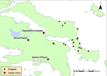
A detailed survey of Hellenic Military Geographical Service (1980 series) maps of Euboea identified 14 similarly named sites located in an elevated position close to the coast, whilst a further three were found in Boeotia (Fig. 3).Footnote 37 No reference to the word pyrgari could be found in any dictionary (ancient, medieval or modern),Footnote 38 but it was identified as a placename twice in an audit of the holdings of the bishop of Cephalonia in 1264.Footnote 39 The presumption may therefore be that this Greek-style name (rather than the later toponyms such as ture, tourli, and turetta) has its origins not in the Frankish but in the Byzantine period prior to 1204.
Pyrgaria identified in Euboea, Attica and eastern Boeotia.

Similar towers have been reported on Rhodes (Ag. Minas, Cape Vigli).Footnote 40 In southern Euboea a classical period circular tower (external diameter 5.35 m), which appears to have been still in use in the Byzantine period, has been identified in a strategic position on the Paximadi peninsula south-west of Karystos (Seifried and Parkinson Reference Seifried and Parkinson2014, no. 13).
COMMUNICATIONS CHAINS IN CENTRAL GREECE
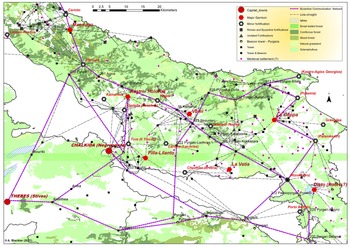
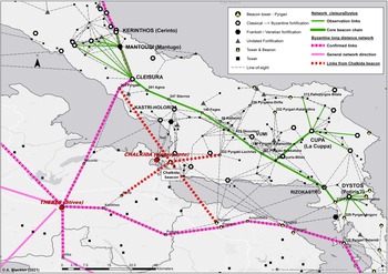
Fig. 4 shows a complex Byzantine communication network linking Thebes, the capital of the thema of Hellas, to the island. It is clear that the chains of beacons were very precisely defined by engineers, since they often travel not over the mountains but through them, frequently following a course up a valley or along the side of a hill to ensure line-of sight to the next node.
Byzantine communication chains in Central Greece.

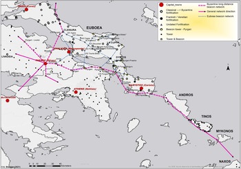
One chain of beacons heads north towards Cleisura, probably a Justinian era refuge fortress, and thence could have continued up via the island of Skiathos to Thessaloniki. A second links to Chalkida and then up to another possible Justinian refuge fortress at Kastri-Holorita. The third requires special treatment. Toponymic references such as Kallithea (good view) and Amphithea (view on both sides), placenames very common in Greece, suddenly take on a new meaning of strategic military importance. This chain initially runs east, Thebes–Kallithea (with a junction to Negroponte), then on to Pyrgari, at which point it divides into two: the north-easterly chain links with the tower close to the small fortification of Leriche (Greek Lechries), then the tower at Skounteri, and thence up over the saddle of Mt Dirfis (1743 m) and towards the fortification of Agios Georgios on the eastern coast of Euboea, effectively controlling all movement of ships up the western Aegean; the southerly chain continues further east via Pyrgari, Amphithea (Kalamos), and Pyrgarti. Here it splits again, one branch crosses the Gulf of Euboea towards the fortresses of Dystos and La Cuppa; the other heads south-east along the western seaboard of Euboea via the islands of Andros, Tinos, and Mykonos to Naxos, from where it was possible to control all movement of shipping in the central Aegean (see the ‘Byzantine long-distance beacon network’ in Fig. 5).
Byzantine communication network in the thema of Hellas.

It is this last chain of beacons that seems to have been adopted by the Venetians in the fourteenth century, although theirs commenced not in Thebes but in their regional capital of Negroponte. Although they have not been surveyed as yet, there are intimations that other communication chains spread out from Thebes: one north-west up the River Kifissos valley via Pyrgari (as suggested by Bon Reference Bon1937), a second west to the fortresses of Leivadeia and Davleia, another south-west down to Corinth and a fourth to Athens and the Saronic Gulf (see the ‘General network direction’ in Fig. 5). These effectively covered all the region of the Byzantine thema of Hellas,Footnote 41 and in many ways mirror the defensive umbrellas established on the Byzantine land borders in Syria and to the east.
Ragia (Reference Ragia2009) has proposed that the setting up of official warehouses in the Aegean (Aigion Pelagos, Hellas, Crete) in the late seventh century followed their establishment in Asia Minor some 30 years earlier. One seal (687–9) refers to the ‘Cyclades’ (a group of islands around Delos in the central Aegean) by which, she suggests, we may presume that the old Roman province of ‘Nesoi’ had been dissolved at this time and this was a new administrative unit within the thema of Hellas.Footnote 42 The justification for a chain of beacons down to Naxos then becomes clear. If this is so, and it was part of a general administrative and military reorganisation of the region, then this raises the enticing question as to whether the ‘Leo’ on the inscription found at Corinth actually refers not to Leo VI (886–912) as Rife suggests (see above), but to Leo III (717–41), in the same way that imperial dedications were made on towers on the walls of Constantinople during his reign.
COMMUNICATION METHODOLOGY
Either way, the strategic need for a means of communication between the three administrative divisions of the Aegean and that in the Adriatic is clear. The main fleet was probably based at Samos to cover against Arab attack up the Asia Minor coast; the thema of Aigion Pelagos, roughly based on the old Roman unit of Nesoi, included the islands of the central Aegean; meanwhile, the thema of Hellas, covering Central Greece and the Peloponnese, had its furthest extent to the Cycladic islands. Further west, the Adriatic fleet operated out of Cephalonia (where examples of the pyrgari were also noted above) and ports on the western Greek coast. It is very clear, therefore, that the Byzantine strategic structure in these centuries was very sophisticated.
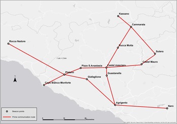
This is to some extent reflected in the method of signalling. At the beacon points in Byzantine Sicily identified by Modeo and Cutaia (Reference Modeo, Cutaia, Congiu, Modeo and Arnone2010) the remains of three fire pits (Fig. 6) were found. By lighting one or a combination of two, or even all three, sophisticated messages could be transmitted. The role of one Sicilian town, Naro (Agrigento), has even been enshrined in its coat of arms: three lit beacons perched atop tall towers.
Network of beacons in south-west Sicily. Based on Modeo and Cutaia (Reference Modeo, Cutaia, Congiu, Modeo and Arnone2010, fig. 2).

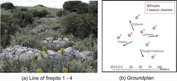
At a height of 180 m on a hill above the classical city of Chalkis, about 3 km east of the medieval city of Negroponte, there exist similar constructions. These are circular with an external diameter of 5 m and walls of rough-cut stones about a metre high (Fig. 7a), providing a space within for a fire 3 m wide. Dating is very difficult, but construction may date from as early as the Hellenistic period.Footnote 43
Firepits on Vathrovouni hill above ancient Chalkis. (a) Line of firepits 1–4. (b) Ground-plan.

There are seven firepits in all, laid out in a crucifix form at an approximate distance of 22 m from each other, with four pointing in a direction of 344° and four to 68° (Fig. 7b). Extrapolating these bearings, we can see that they point directly to Thebes, to the fortress of Cleisura, and south-east to a pyrgari on the mainland. Slightly obliquely – but still discernibly – they also point east towards a beacon site above the fortification of Lechries (medieval Leriche) and might be discernible at the (probable) Justinianic refuge fortress of Kastri, directly north (see red/regular broken lines on Fig. 8).
The core Euboea beacon chain (green/solid), signal directions from the firepits above Chalkida (red/regular broken) and the network links from Thebes (mauve/irregular broken).

The system for interpreting the complex signals that would have been generated by such a configuration can also been identified in the architecture of a surviving tower on Euboea – that at the village of Mistros. This demonstrates how an observer could distinguish between each of (probably) three beacons from a distance of about 2 km. On two contiguous walls (the north and west) the arrow slits at first floor level were deliberately angled so that the left wall of the left slit and the right wall of the right slit were focused on the same bearing (298°) – what would have been the central brazier of (one assumes) three. This allowed the observer by moving from one window to the other to identify which of the three beacons had been lit. Unfortunately, the dating of the tower is difficult to assess. With four massive support beams for the first floor, it is unlike any other surviving tower on the island, but its architecture of rough stone and mortar could make it either Byzantine or Venetian in origin. Its role seems to have been to communicate between the village of Mistros situated in a small well-watered valley to the south-east, where troops were probably billeted, and the central stables at Skountéri (escuderia [Italian] = stables), which is in a very exposed position, the name possibly suggesting a Venetian origin.
THE CENTRAL EUBOEA BEACON CHAIN
The two Byzantine fortresses of Cleisura and Cupa, each of which controls access via a deep gorge to central Euboea, have been mentioned above. Following reconstruction of the probable medieval topography of the island it was possible to identify a clear chain of towers linking the two (Fig. 8 – green/solid line), running in a south-easterly direction along the spine of the island.Footnote 44 The original defensive network, which appears to have initially extended to the classical fortresses of Dystos in the south and Kerinthos (via Mantoudi) in the north, was probably readopted by the Venetians in the late fourteenth century.Footnote 45 It was deemed so important for the general safety of the populace that a special tax (the vigliatiko) was even raised by the Venetians to pay for its maintenance.
The primary chain appears to have been carefully planned, being (with minor deviations) an approximate straight line, with branches to the eastern and western coastlines. Apart from Negroponte it covers five major fortifications (Dystos, Rizokastro, Cupa, Kastri-Holorita, and Cleisura) and Vumi, possibly the most populous town apart from Negroponte, while other towers all had a view to at least one node of the network, directly or indirectly. Most nodes in the chain are clear but there are so many links that the actual route may have evolved over time. Was Kathenoi, for instance, part of the network or was the signal passed directly to Feges? The existence of other more localised communication chains is also possible, although the evidence is insufficient to clearly delineate them. The form of the network dramatically highlights the way in which the Byzantines seem to have originally fortified the central region of the island,Footnote 46 creating an effective wall of forts and watchpoints at two points (north-west and south-east) where the coast-to-coast distance is less than 15 km.Footnote 47
Other defensive networks
The importance of the effectiveness of a communication system can be seen in a GIS study undertaken of the Hospitallers’ fortifications in the Dodecanese, centred on Rhodes. Their ability to track potential attackers and a rapid response by their fleet seems to have been the key to their success against Turkish incursions (Zafiris and Brokou Reference Zafiris, Brokou, Burenhult and Arvidsson2002; Heslop Reference Heslop and Upton-Ward2008). In a similar manner, a study of the Byzantine fortifications of Thrace in the ninth to fifteenth centuries concluded that, whatever the strength of the fortifications ‘the best defence of the coast was provided by a well-trained, war-ready and sufficiently numerous force of soldiers’, which would have depended on a good communication system to be effective (Tsouris Reference Tsouris and Damoulos2012, 586). It would also have been a prerequisite for the basic Byzantine military strategy up to the early tenth century, as expounded in the De velitatione bellica (a system of skirmishing warfare) which depended on intelligence about the location of the enemy (McMahon Reference McMahon2016). The Venetians, too, established networks on Crete, Tinos and Cephalonia for similar reasons: we have documents from the sixteenth century detailing a sophisticated system on the last island, noting the planned construction of 126 watchtowers and the personnel and resources necessary to maintain it.Footnote 48
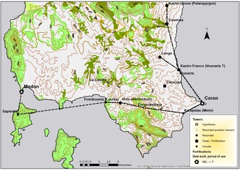
Further south in the Peloponnese, the Venetians constructed another network of beacon towers linking their fortresses of Corone and Modon, both key waystations for their fleet travelling to the eastern Mediterranean (Fig. 9). Again, by using documentary and archaeological evidence in conjunction with GIS viewshed analysis, we can identify the structure of this and how they identified a route not over but up the valleys through the mountains separating the two fortresses (Blackler Reference Blackler2020, 542–3).
The 15th-century Venetian beacon network in the south-west Peloponnese.

Wooden beacon towers
An important feature of one part of this network is the tower on the island of Sapientza. The usual presumption is that beacon towers, being built of stone, can be identified by the archaeological footprint they leave. Yet this tower, our documentary source notes,Footnote 49 was constructed of wood, as was another constructed further north to protect the Venetian salt pans close to Corfu. Our source for the latter, a minute of the Venetian Assembly, exhorts the construction of a stone tower, but accepts that a wooden one would be adequate.Footnote 50 Similarly, Anna Comnena three centuries earlier writes of the erection of wooden towers by the emperor Alexios I (1081–1118),Footnote 51 whilst in the Taktika of Leo VI their use is noted to defend a river crossing (Taktika 17.42–7, in Dennis Reference Dennis2010). We need, therefore, to be very careful in presuming that a lack of evidence – wooden towers leaving a minimal archaeological footprint – proves that a beacon chain did not exist.Footnote 52 It is also quite possible that, where a convenient hillock with a good viewshed in a secure position existed, nothing more than a simple hut for a watchman was constructed,Footnote 53 the large size of beacon required for a long-distance chain of beacons anyway obviating the need for a tower.
THE ROLE OF THE MEDIEVAL TOWER: A THEORETICAL APPROACH
The essence of the medieval tower – except the pyrgari or vigla – is its defensive capability compared to other relatively fragile buildings in its immediate environment, a role stretching back into antiquity in the eastern Mediterranean.Footnote 54 Just in one small region, the Paximadi peninsula in the south of the island of Euboea, Seifried and Parkinson (Reference Seifried and Parkinson2014) have identified 25 towers constructed in the Classical and Roman periods, some of which show continuous use into the Late Medieval period. Recent work by Kostis Smyrlis (Reference Smyrlis, Daim and Drauschke2016) on the archives of the monastic enclave of Mt Athos in Northern Greece provides documentary evidence of towers in an estate context from as early as the tenth century, whilst numerous articles have been published by Greek authors on the surviving towers in Macedonia.Footnote 55 We also have a deliberation of the Venetian Senate in 1402 which notes that, in order to combat Turkish attacks, well-fortified dwellings (towers?) should be constructed to receive the ‘serfs and villeins’, thus suggesting a defensive role similar to the Byzantine towers in Macedonia (Thiriet Reference Thiriet1958, vol. 2, 24, no. 1041 [10 February 1402]).
For most of the time, however, towers probably fulfilled ancillary roles: the fine stonework on some indicates some attempt at display, a few have domestic comforts (fireplace, latrine), whilst their use has been noted at harbours,Footnote 56 and has even been documented for storage of grain and wine.Footnote 57 One tower, whose ownership was in dispute between the Venetians and one Giuglielmo Sanudo of Negroponte, was especially useful, as noted in a minute of the Senate (1361), for collecting the commercium (customs duties).Footnote 58 These roles appear at first sight incompatible to the tower's defensive function, yet even major fortifications generally had little more than a caretaker staff for most of their existence: in the fifteenth century – a period of supposedly high risk – there were only five companies of professional soldiers (120 men) for the whole of Venetian Euboea to cover 12 major fortifications, whilst on the island of Tinos in 1621 only two guards were assigned to each coastal watchpoint.Footnote 59 Thus, for the defensive points to be effective, there was a necessity of early warning for the local militia to assemble, and the inhabitants to gather within them or disperse into the mountains.
The time appears ripe, therefore, to provide a theoretical framework, which encompasses both strategic and more mundane domestic, administrative and agricultural roles. My work on the island of Euboea has shown that, contrary to previous conclusions (Lock Reference Lock, Lock and Sanders1996), all of the 142 tower and beacon sites identified had line of sight to another site or major fortification. This, however, does not prove that there was some overall strategic blueprint for their construction: I argue below that it was only the core network and coastal watchtowers which were planned.
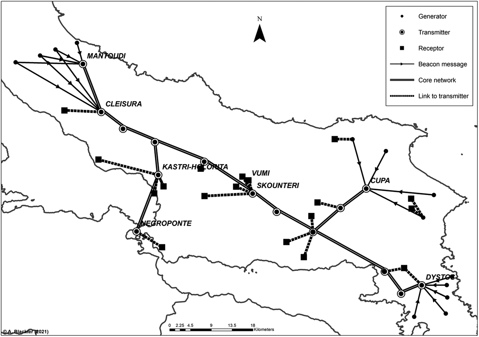
To prove this, we can profitably study in more detail the Venetian communication network on Euboea, much of which (as discussed above) was most likely adopted from a pre-existing Byzantine model. Three distinct communication functions can be allocated to each tower; these can be conceptualised in a simple way using the analogy of the modern electricity network of wind turbines perched on hills throughout the island:
• The generator (wind turbine), which equated to a watchpoint (pyrgari/Vigla/skopia) from which sentries, having identified approaching corsairs, would send a message into the network;
• The transmitter (substation) whose role was to pass on the signal received from a local watchpoint or another transmitter along the core communication chain or to local receptors;
• The receptor (residence or commercial premises), equivalent to an estate, administrative or military position, which ‘consumed’ the warning signal, each tower only being alerted of danger and action appropriate to its role, but not passing on the signal.
The network is drawn in Fig. 10 schematically, and for clarity most towers have been omitted. Arrows show the direction of information flow, which in the central core was probably bi-directional. Dotted lines indicate that communication terminates at the receptor node. Generators can also transmit direct to a receptor, effectively creating a local defensive network, as in two towers to the east of Cupa. For simplicity, secondary links (the majority) are not shown but can be identified in Fig. 8.
Schematic of central Byzantine / Venetian network on Euboea showing division between generator, transmitter, and receptor towers.

The network stretched for 66 km from the fortresses of Dystos (Disto) and Cupa (La Cuppa) in the south to that at Cleisura (under the Byzantines) and Mantoudi (Mantugo in the Venetian period) in the north. A mounted strategic reserve probably stationed at Skounteri, the approximate centre of the network, could thus intervene against any coastal attack within five hours. The chain to Cleisura consisted of a minimum nine nodes (possible maximum 15) with an average distance between them of 8.3 km and a maximum of 14 km – well within the distance required for reliable communication discussed above. Along the chain many other towers had line-of-sight to its nodes, providing a warning of impending danger for all living in close proximity, although much of the central core travelled through a mountainous region so primary local links there are few.
Many towers have only one role, but roles are not mutually exclusive, and it is quite possible for a beacon in a strategic position within a well-populated region, such as that at Vathrovouni close to Negroponte, to fulfil all three. The core communication chain linking the major fortresses seems to have been planned, but others probably developed in a haphazard fashion. The location of the receptor estate tower was primarily defined by the topography of the estate, not its position in the network, the only prerequisite being the need to view a transmitter tower/beacon. The location of towers at the highest point of settlements, apart from increased defensibility, then becomes clear – it was to improve their viewshed. Similarly, towers in an administrative capacity at the ports, for collection of taxes, or for control along the roads, were located for such functions, but still needed a link to the central network to ensure their safety.
As Phillip Dixon (Reference Dixon, Meirion-Jones, Impey and Jones2002) noted in a conference publication on French medieval towers, ‘all building of pretty well any age contains in its design an element of display. But that display should seldom be considered the complete reason for construction.’ It is therefore not surprising that some towers appear architecturally superior (better dressed stonework, quoining, cut stone window surrounds, toilet, fireplace), yet in general the towers of Central Greece constructed by the Latin invaders post 1204 up to the fifteenth century are much more functional than surviving Byzantine towers (both secular and monastic) of the same period in Northern Greece, and they are remarkably homogeneous.Footnote 60 A study of the dimensions of 49 surviving towers in Boeotia and Euboea has shown that they are essentially square – a differential between sides of only 5 per cent – with plain external stonework and a mean wall length of 7.4 m (standard deviation 1.1 m), whilst wall thickness averaged 1.3 m.Footnote 61
CONCLUSIONS
The major conclusion we can draw is that intervisibility between towers, their links to major fortifications, and the probable complexity of signalling systems between regions suggest that our approach to understanding the medieval topography in Greece needs to change. There appear to be strong indications that there once existed numerous communication networks, both localised and long-distance, throughout the Byzantine Empire prior to 1204, and that the Venetians developed their own defensive networks often based on these.Footnote 62 Thus, the evidence for the construction of towers for display and control by the incoming western elite in the thirteenth century, when surveying all the towers now known to have existed – both Latin and Byzantine – in the Middle and Late Medieval periods seems, at the least, overstated.
We have also identified the scope to shift the future emphasis of our research to the study of connectivity within the countryside. Archaeological surveys, once heavily site-focused, have now extended to include regions. A good example is the Eastern Korinthia Archaeological Survey, the report of which (Tartaron et al. Reference Tartaron, Gregory, Pullen, Noller, Rothaus, Rife, Tzortzopoulou-Gregory, Schon, Caraher, Pettegrew and Nakassis2006) details geomorphological and environmental work undertaken and uses innovative methodology (GIS and natural sciences) in its analysis. Yet, while emphasising generally that the town's existence and prosperity depended on its position, that study's section ‘Kromna as crossroads’ is restricted to a single paragraph on possible roadways and a short discussion on connective landscapes (Tartaron et al. Reference Tartaron, Gregory, Pullen, Noller, Rothaus, Rife, Tzortzopoulou-Gregory, Schon, Caraher, Pettegrew and Nakassis2006, 508). Similarly, work in Boeotia has generated much academic literature yet there is a sense in these of a static study (Farinetti and Sbonias Reference Farinetti and Sbonias2004; Bintliff Reference Bintliff and Fittschen2007; Vionis Reference Vionis2017), and a focus on dioceses, settlements and fortified positions without detailed modelling of the linkages between them, which modern software now allows.
Despite clear agreement on the relocation of many settlements and populations for security reasons in the sixth to fifteenth centuries (Kontogiannis and Heslop Reference Kontogiannis, Heslop and Heslop2020), there appears to have been no consideration to date that access to a communication node – i.e., a warning of impending danger – could also have influenced settlement location or growth. It has been argued, for instance, that the designs of Hadrian's Wall in Scotland and the Wetterau Limes in Germany were influenced by the needs of signalling (Woolliscroft Reference Woolliscroft2001).
Looking specifically at the island of Euboea, from about 1270 the southern port city and fortress of Karystos fell outside effective Venetian control for nearly 60 years.Footnote 63 When the Republic regained suzerainty in the mid-fourteenth century, the setting up of a beacon network linking the islands of the central Aegean via the city with their capital Negroponte, whilst nominally for defensive reasons, would also have been an important political statement: it not only effectively extended the borders of their empire, but the chain of beacons was a visible display of its assumption of responsibility for the security of the population living within this umbrella.
The original construction of this system by the Byzantines in the early eighth century following the creation of the thema of Hellas, if my proposed dating is correct, may be seen in a similar light. The empire was re-establishing the bounds of its domain after a period of major incursions and political instability. It was thus demonstrating to a population that may have been as much Slavic- as Greek-speaking (and whose support it needed) not just its ability to tax them but its use of their money to good effect: it ensured the security of the populace against Arab incursions, and thus united again what were probably many disparate groups under the imperial banner. In a recent article, Vionis (Reference Vionis2017) has provided an extensive analysis and discussion of the landscape and settlement evolution occurring in Boeotia during this period. Study, however, of communication and connections within a wider regional framework may provide us with a further dimension by which we may understand in a more nuanced way the transformations occurring within the medieval landscape of Greece.