Introduction
On 17 January 2012, the Chinese National Statistic Bureau reported that by the end of 2011, China's urban population had increased to 690,790,000 while the rural population decreased to 656,560,000; domestic and overseas media then commented that this was a historical moment when the urban population first surpassed the rural population and constituted 51.27 per cent of the national population.Footnote 1 China has been historically considered as an agrarian civilization. It remained a predominantly rural country before 1949 and the socialist industrialization in 1950–80 did little to change the picture of a few major cities surrounded by an immense rural population. By contrast, the rapid urbanization process over the next three decades drastically altered that picture and made China an urbanized country. And the country will certainly become even more urbanized in the near future as the process is still ongoing.
This phenomenal change is also an imbalanced development as China's vast hinterland is still rural and underdeveloped. It has in fact been driven mainly by the massive growth of the major urban centres that draw waves of immigrants from rural villages and small towns. By 2008, there were 13 Chinese cities with over four million residents, 41 cities with over two million and 122 cities with over one million.Footnote 2 Most of the great cities with multi-million residents are located in the coastal area, such as Beijing, Shanghai, Guangzhou and Shenzhen; there are also great second-tier cities in hinterland provinces, such as Chengdu, Chongqing, Wuhan and Xi'an. These cities are the engines of growth in national and regional economies.
Beside the tremendous growth in their size, what are the important changes or continuities in the cities’ urban structure and forms and in the production of new urban spaces? This article seeks to answer this question by examining city planning and urban construction in the great cities through the six decades of the People's Republic. Seeing beyond the radical change in the last three decades, I intend to theorize the urban restructuring process through the six decades. While to conceptualize the entire urbanization process is beyond the scope of this article, I seek to interpret one crucial aspect of the process, namely the making and remaking of urban forms in relation to state governance and official ideology. In particular, I aim to show the persistent contradiction between ideology and planning, on the one hand, and urban sprawl (urban expansion that lacked co-ordinated planning) and cellular urbanism (cities consisting of walled compounds), on the other.
The enduring significance of official ideology in urban development lies in the symbolic function of city planning. In the imperial period, city planning symbolized sacred cosmology and the mandate of heaven and thereby legitimated imperial rule;Footnote 3 in the socialist period, city planning continued to perform the symbolic function of legitimating the new state power and was also a formal exercise to promote the state's economic policies; in the post-socialist period, city planning serves to symbolize the legitimacy and ‘rationality’ of the development-driven governance.
The symbolic function of city planning gives the city a unified formal structure, which is, however, often compromised in the process of urban building and development. In the imperial capitals, straight and wide avenues that formed a symmetrical grid defined huge residential blocks or wards within which building activities were much less controlled. Over time, civilian constructions encroached on the avenues and made them narrower and irregular.Footnote 4 In the socialist and post-socialist period, city planning was in contradiction with its relative lack of practical values and ineffective implementation. This incongruence between city planning and urban construction betrays the contradiction between the unitary state ideology and the governance strategy of dividing the urban population and their space into cellular units. This ‘divide-and-rule’ strategy, to borrow a term of Elizabeth Perry,Footnote 5 incurred a lack of co-ordinated and effective city planning, which in turn led to the contradiction between utopian planned spaces and dystopian urban sprawls.
My theorization of planning (economical or spatial) and ‘its discontents’ through the socialist and post-socialist periods suggests a different approach to Chinese urbanization from most recent studies in the field. Scholars in Chinese urban studies have adopted the paradigms of modernization, globalization (or the world system) or state entrepreneurism (the neoliberal or developmental state) in conceptualizing the radical urban change since the reform era.Footnote 6 John Logan and his colleagues seek to combine all the above theories and the theory of transition from the socialist legacy in interpreting the complex process. All these theories that have been used to explain urbanization elsewhere in the world are now applied to the Chinese experience.Footnote 7
John Friedman cautions that Chinese urbanization may not fit into the narratives of any grand theories (that emphasized globalization or external impacts). He argues China is not just a nation-state but a civilization with a continuous history from antiquity to the present: it deserves to be understood on its own terms. He stresses Chinese urbanization as an evolutionary process that is driven from within.Footnote 8 His comprehensive examination of scholarly works attempts to bridge the immense gap between the rich literature of Chinese urban history of the imperial and Republican periods and the rapidly growing literature of contemporary Chinese urbanization. The former is produced by scholars trained in history and sinology (or Chinese studies); the latter by scholars trained in the social sciences who seek to adopt (or modify) ‘western’ theories rather than explore the historical roots of current transformation by consulting the historical literature.
Inspired by Friedman's ambitious project, I aim to conceptualize the current urban change in relation to the legacy of revolutionary governance since 1949, and to show continuities amidst radical changes. For example, I argue that state ideology continues to play a pivotal role in urban development; this argument differs from Antony Yeh and Fulong Wu's earlier assessment that the dominance of ideology in city planning and urbanism was over.Footnote 9 My emphasis on continuity with the socialist period echoes such arguments as the reforms’ partialness or incompleteness, which are developed from the theory of transition from the socialist legacy. But instead of viewing this incompleteness as part of a teleological process of transition, I see it as a new manifestation of the ongoing legacy of state ideology and governance. Indeed, the great Chinese city continues to evolve on its own complex terms rather than simply being shaped by a process of transition toward a predetermined or imported model.
The origin of work-unit urbanism
After defeating the nationalist army in 1949, the peasant army (People's Liberation Army) led by the Chinese Communist Party (CCP) took over the major cities and soon a new revolutionary government was established. The new regime inherited many features of the Party's wartime governance of base areas in rural China, such as the combination of central Party leadership and decentralized military and economic production units. During the Japanese occupation of northern China, the Party encouraged its military units to establish remote base areas and managed them as autonomous units for military and economic survival while accepting the leadership of the Central Party Committee in Yan'an.Footnote 10
Moving into Beijing and other great cities, the Party's military and bureaucratic units were eager to create their new autonomous ‘bases’, which then took the form of walled compounds, closed off from any ‘horizontal’ connections with other units and with the city at large while accepting the Party leadership from above. The compounds of these powerful ‘work units’ (danwei or jiguan) took form before any comprehensive urban planning was conceived for the city. Many bureaucratic units occupied the former imperial aristocratic mansions (wangfu) or built small compounds on random land patches in the old city, while the great military and educational units built immense compounds (dayuan or great courtyards) in the city's sprawling suburb.Footnote 11 To a less extent, similar work-unit compounds were built in other cities. This ad hoc urban construction feature marked the Economic Recovery Period (1950–52) and continued in varying degrees throughout the socialist era.
After the recovery period, the Party sought to industrialize China rapidly and to catch up with the advanced capitalist economies in decades. This ambitious programme embodied a revolutionary utopianism, which, as I will show, has continuously informed state-led construction programmes since the success of the Communist Revolution in 1949.
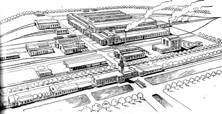
The Party first adopted the Soviet model of modernization in launching the First Five-Year Plan (FFYP, 1953–57). The plan was a centralized economic programme that emphasized achieving quantified economic targets more than regional or urban spatial planning. It featured the construction of 694 large industrial projects, including 156 Soviet-aided heavy-industry projects. These key projects involved spatial planning that aimed to create model units of socialist work and living. They combined the traditional walled compound with modern functionalist planning and architecture. Their main entrance usually featured a gate and a square in front of the main administrative building, behind which workshops or offices spread forth to form an orderly layout (Figure 1).Footnote 12
Arial view of Locomotive Repair Plant, Changchun, c. 1957 Source: Jianzhu xuebao, 10 (1957), 42.
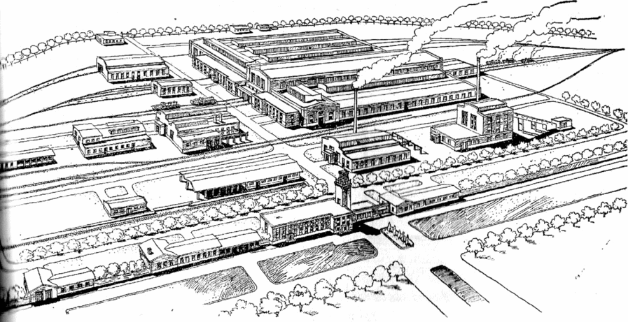
These model industrial units inherited the autonomous feature of the Party's military and bureaucratic units mentioned above. Their walled compounds were usually built next to the old city and stood in contrast with neighbouring urban quarters or rural villages.Footnote 13 The city as a whole was then fragmented by these self-sufficient compounds which in fact made it unnecessary to build open-style urban facilities such as parks and shopping centres. The patches of planned spaces together formed a less orderly urban sprawl that took form before any comprehensive urban planning was envisioned or implemented.Footnote 14
Centralized planning and spatial fragmentation
The FFYP initiated the national planned economy (jihua jingji); centralized economic planning has since set the main course of Chinese industrialization. Soviet-style urban planning was also introduced as part of the new economic programme. A team of native and Soviet planners quickly produced a number of master plans for those cities with three or more Soviet-aided projects; these plans were quickly superseded by new master plans that reflected new economic policies and had never got implemented.Footnote 15
The factional struggle within the Party leadership, however, led to Mao's criticism of Soviet-style modernization. Pursuing the idea of ‘walking on two legs’ – one was urban-based industrialization, the other was grassroots and rural-based – Mao launched the Great Leap Forward that mobilized peasants and unemployed urban residents to participate in a ‘mass-line’ (or people's) industrialization campaign. In promoting the collectivization of rural economy, Mao proclaimed:
Our nation's socialist economic revolution, political revolution, ideological revolution, technological revolution, and cultural revolution are advancing forth. Thus, it probably will take less time to catch up with the great capitalist countries than we previously thought. Apart from their other characteristics, China's 600 million people are, first of all, poor, and secondly ‘blank.’ That may seem like a bad thing, but it really is a good thing. Poor people want to change, want to do things, want revolution. A blank sheet of paper has no blotches, and so the newest and most beautiful words can be written on it, the newest and most beautiful pictures can be painted on it.Footnote 16
Using the ‘blank sheet’ as a multivalent metaphor for the ‘poor and blank’ country and simple-minded peasants, Mao advocated a utopianism of ‘permanent revolution’ that would repeatedly negate the past and rapidly create a totally new world as a preconceived plan or picture on tabula rasa.
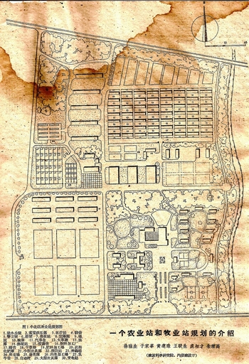
New master plans were drawn for cities and rural communes that were expected to grow rapidly (Figure 2).Footnote 17 Yet, like their predecessors in the FFYP, these plans were never implemented. As Yeh and Wu comment on the period, ‘urban planning was often the slave of political propaganda, its involvement in the unhealthy promotion of growth has led to disastrous results for the national economy, which eventually caused the abolishment of urban planning itself during the Cultural Revolution’.Footnote 18
Plan of Xiaobaidian Agricultural Station, Tugui Township, Inner Mongolia, c. 1959 Source: Jianzhu xuebao, 1 (1959), 19).

The Great Leap Forward and Cultural Revolution were the extreme outcomes of Mao's revolutionary ideology and mass-line, anti-bureaucratic and anti-urban strategies. They resulted in social anarchies and chaos that disrupted the nation's economic planning. Beyond these extreme times, the contradiction between centralized planning and anti-bureaucratic grassroots movements persisted throughout the socialist era and was spatially manifested in the contrast between the new political centre and a sprawl of work-unit compounds – the former was orderly and planned to symbolize new state power, while the latter appeared to be random patches inserted into, and sprawling from, the old urban fabric.
Even before myriad work-unit compounds mushroomed in and around old Beijing, the Party leadership commissioned a city planning committee (Beijing dushi jihua weiyuanhui) to consider a new city plan that would transform the former imperial capital into a new national political centre and socialist city. A debate ensued on whether new Beijing should be a new city built adjacent to old Beijing or a radical transformation of old Beijing. The leaders adopted the latter plan to rebuild the area around Tian'anmen (an imperial city gate) into a political square and national monuments and the city walls into wide avenues. Beyond the Tian'anmen Square and behind the avenues, urban planning was hardly effective when it confronted the interests of various work units, whose autonomous building pattern often defied any planning codes and contradicted the city master plan.Footnote 19
The spectacular square and avenues displayed a monolithic state power while concealing the fragmentation of this power, whose resilience lay precisely in the constant negotiation between the central leadership, bureaucratic departments and grassroots work units. This would explain why the party leadership rejected the plan of building a new capital west of old Beijing: as the Party's various units already occupied the old city centre and divided up the suburb, they would prefer their ‘autonomous bases’ (scattered and hidden in the old urban fabric) and resist moving into a centralized administrative centre.Footnote 20
Rebuilt from the old imperial centre, the new political centre functioned as an empty symbol or occasionally a stage for political rallies. By contrast, the real operation of power was deeply concealed in the urban labyrinth of walled compounds. This in fact greatly limited what urban planning could achieve in the socialist city, as Yeh and Wu comment:
The urban process was characterized by the distinctive feature of conflict and fragmentation between sectoral and territorial systems. The decision-making process was both highly centralized within the central governments and ‘decentralized’ within a vast number of state production units and institutes. The provincial, county and municipal governments were structured in a similar way, in which they also controlled various enterprises and ‘cellular’ units. This structure made unified urban planning difficult, if not impossible. Programming city development became even more difficult because of constant political struggles over the factions of cadres, commands from those ‘gatekeepers’ in decisive positions and fluctuating macro economic policies.Footnote 21
The contradiction between planning and spatial fragmentation was also found within the work-unit compound, whose growth and multiplication often resulted in the contrasting orderly main compound and less orderly living quarter (usually as a separate compound adjacent to or a distance from the main one). As the state's centralized economic planning emphasized production rather than providing adequate funding for housing construction, the growing work units had to solve their housing shortage problem outside the state-approved fiscal plan and build apartments and living amenities without city planning approvals. Such ‘illegal’ constructions were extremely common in Beijing's west suburb where great work-unit compounds took form in the fifties and continued to build and expand in the sixties and seventies.Footnote 22
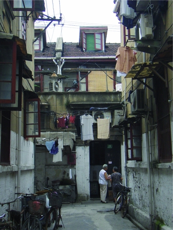
Spatial fragmentation in the city's residential quarters appeared even more chaotic. Just as the work units rebelled against urban and economic planning, the residents subverted the original architectural design of their home. Everyday life in both work-unit residences and old street neighbourhoods entailed the residents’ improvisational measures to cope with the scarcity of living resources and spaces, especially when housing shortage became a serious problem after the rapid growth of urban population during the Great Leap Forward. Most residents carried out self-help rebuilding in or around their homes in order to alleviate the extreme shortage of living space. During the Cultural Revolution, when all levels of authorities were challenged, working-class people with no or little living space ‘occupied’ private homes from the pre-revolutionary era, whose original owners were now allowed to keep only a fraction of their former home. This drastically increased the density of old neighbourhoods and the self-help rebuilding activities spread to any spaces available.Footnote 23 Old courtyard houses in Beijing and lilong (alleyway) houses in Shanghai, for example, went through excessive subdivision and rebuilding after they were transformed into public housing: a lofty room rebuilt into two floors; a kitchen extending into the courtyard or balcony, and shelters mushrooming on rooftops (Figure 3).Footnote 24 In newly built work-unit residences, residents reclaimed common areas such as corridors and staircases and used them as private storage or cooking spaces.
A decayed lilong neighbourhood at Xinzha Road, Shanghai ©Samuel Y. Liang, 2007.

Such grassroots spatial practices contributed to the decay and deterioration of the everyday environment in urban neighbourhoods. This seemed inevitable given the lack of public investment in housing construction and maintenance. Toward the end of the socialist era, the densification of old urban quarters and work-unit compounds of various sizes, shapes and locations formed an extremely complex and fragmented urban geography, in which little evidence of planning control was visible.
Urban sprawl in the early reform period
In the wake of the apparent failure of the Maoist ideology and centralized economic planning, Deng Xiaoping's economic reforms (re)introduced the market economy, which was advocated as the opposite of, and a cure to, the stagnant ‘planned economy’. But the latter did not just disappear; it co-existed with the market economy to form a more complex balance between central control and local production.
Deng's pragmatic and experimental approaches in liberalizing the economy were in fact indebted to Mao's anti-bureaucratic campaigns. The early reforms in rural villages and cities sought to increase the productivity of the grassroots units (rural production brigades and urban work units that had been the units of Mao's permanent revolution) by freeing them from the rigid central planning system. As the reforms unfolded in urban China, not only did the work units (i.e. state-owned enterprises) acquire more autonomy in the market economy but the municipal government also gained considerable fiscal independence from Beijing. The socialist contradiction between centralized planning and mass-line ideology then evolved into the negotiation or collaboration between different levels of decentralized state power and a range of market forces that included reformed work units. This change was reflected in a new urbanism that continued as well as diverged from the old pattern of urban development.
The reforms spawned a construction boom that led to the rapid urban growth of the major cities. In this process, the cellular urbanism of work-unit compounds continued on a larger scale. Because of the extreme shortage of urban housing in this period, work units, sometimes in collaboration with the city government, built a massive amount of public housing for their employees, usually on any land parcels they managed to acquire in city-centre or outskirt areas.Footnote 25 Many new apartment buildings or small compounds appeared to be randomly inserted into the extant urban fabric – which the natives vividly depicted as ‘sticking needles into any cracks’ (jianfengchazheng). Newly built multi-storey walk-ups consisted of ‘concrete-shell’ apartments, in which residents had to have basic living amenities fixed. Telephone lines, TV cables and air conditioners were soon added ad hoc to the buildings, which then appeared to be buried in the chaotic entanglements of wires and affixtures (Figure 4). Thus, the socialist city continued to decay in an accelerated process of densification in the early reform period.
Apartment buildings in Guangyuan Xincun, Guangzhou, built in the late 1980s ©Samuel Y. Liang, 2008.

As the market economy developed, the work-unit system evolved into a heterogeneous spread of interest groups and corporate powers. Sometimes their profit-driven projects changed the sites’ ‘land-use categories’ without approvals from the city planning authority. For example, many work units located at busy streets built commercial facilities to replace street-facing walls, and leased them out to generate income. Some work units formed joint ventures with overseas investors to develop commercial projects on the industrial land parcels they occupied.Footnote 26 Such construction projects without municipal approvals soon became ‘illegal constructions’ (weizhang jianzhu) after the city planning authority was reinstalled in the major cities.
A series of regulations had been passed by the late 1980s to regulate the urban growth. These include the City Planning Regulation in 1984 and the City Planning Act in 1989.Footnote 27 Yet, the enforcement of city planning lagged behind the construction boom and land transactions, and urban growth in the (early) reform period generally produced disorderly sprawls. This pattern of growth continued well into the 1990s.
City planning in the post-reform period
At the turn of the millennium, China entered the post-reform period and the great cities such as Shanghai and Guangzhou envisioned more ambitious developments toward the target of the ‘international metropolis’. The cities sought to structure urban growth and restore spatial order by launching comprehensive urban planning and large-scale rebuilding projects. This would signify a return of ‘planning’, though it was now a spatial project in local urbanization rather than a centralized economic programme. Yet, similar to the latter, city planning is still a top-down bureaucratic process without the participation of the general public, and its implementation is still not effective.
As Yeh and Wu comment on city planning in the post-reform area, ‘nowadays it again becomes the tool of ambitious government officials to promote local economic growth’, as it was the slave of political propaganda.Footnote 28 In particular, the master plan (zongti guihua) that reflects long-term policies is still a formal exercise that legitimates the new developmental governance.Footnote 29 The new ruling elites, many of whom had been trained as engineers, always promote new development plans as ‘scientific’, ‘rational’, and ‘sustainable’ programmes in contrast to the earlier ‘irrational’ economic planning.
Yet, the new master plans often include some unrealistic targets that are reminiscent of those of the Great Leap Forward, such as that to catch up rapidly with the advanced capitalist economies. Many a provincial city aims to build up a world-class central business district (CBD) that features cutting-edge architectural designs and satellite towns that represent innovative types of urban development. This transformation of the socialist city into a transnational space (imagined after such world cities as Hong Kong and New York) continues to envision a radical break with the recent past.Footnote 30 The ghost of Mao's ‘permanent revolution’, it seems, survives in the permanent demolition and rebuilding of the post-socialist city; the socialist past is now negated because it is backward, if not utterly ‘poor and blank’.
Compared with the ‘symbolic’ master plan, detailed city planning (xiangxi guihua) is supposed to be more pragmatic and instrumental in development-driven governance. Yet, its implementation is rarely effective, as Daniel Abramson points out: ‘local area plans tend either to be subverted by development, or used as blueprints for it. They rarely serve as regulating tools over the long term, and they are compromised from the outset as instruments of the public interest.’Footnote 31
One main problem in local area planning is that the planning authority and the land leasing authority (the National Land Bureau that sells land-use rights to developers or land users) are separate administrative units between which there is little or no co-ordination. Since the Constitution was revised in 1988 to legalize the commercial transaction of ‘land-use rights’, local authorities were able to lease land to commercial developers and a booming land and property market soon followed. But the administrative allocation of land (to work units) was not abolished. It co-existed with commercial land leasing to form what Antony Yeh calls a ‘dual land market’.Footnote 32 This system generates a mixture of work-unit urbanism and new commercial developments.
The way in which the land is divided into parcels for lease reflects the historical conditions of urban land (occupied by work units and residential neighbourhoods) and the local government's short-term strategy in attracting investments rather than conforming to the long-term city plan. In fact, the land users or developers are either state-owned enterprises or private companies with strong connections to the local government, and they are often assisted by local officials in negotiating with the planning authority in order to maximize profit. Thus, the old pattern of cellular urbanism continues, though land parcels leased to commercial developers are increasingly large.
The developers promote the concept of planning and design for their developments, which usually take the form of residential compound or gated community. This new urban form reinvents the old form of cellular compound and is quite comparable to the socialist work unit and even to the walled mansion in the imperial period.Footnote 33 While the work-unit compound was separate from and in contrast to the pre-revolutionary city, the new residential compound is packaged and marketed as an escape from the decayed socialist city. The upscale compounds consist of fine landscape and fashionable villas or apartments sold to China's emerging ‘middle class’ who are eager to move out the old neighbourhoods of mixed residents.Footnote 34
Like work units of similar sizes, large-scale residential compounds are usually located in the suburb. Far away from the developed urban area, each of these self-contained communities has a complete set of exclusive facilities such as the clubhouse, shops, kindergarten and school, which are quite expensive to maintain.Footnote 35 The developers and property managements tend to organize the compounds’ community life in a closed rather than open urban style; they produce a new form of ‘little society’ as did the work unit. Thus, the geography of the post-reform city is still fragmented and features a greater degree of residential segregation than the earlier periods.Footnote 36
This cellular urbanism is very different from the practice of zoning, which is a key concept in modern city planning. A city's zoning codes regulate properties on small land lots owned by private individuals or companies. By contrast, Chinese city plans are negotiable and adjustable when large compounds are being built. These compounds and their developers represent interest groups that are neither public nor private. Their ambiguous status as the state's agencies between the government and its subjects is comparable to that of work units in the socialist period and the administrative residential wards in the imperial period.
Guangzhou's strategic plan and University Town project
Having sketched a brief overview of the urbanization legacy of the great cities over the last six decades, I will examine the specific case of Guangzhou in this section, focusing on the post-reform period. Guangzhou is a regional centre as well as a first-tier city comparable to Beijing and Shanghai; its latest urban growth illustrates the above features of Chinese urbanism and city planning.
During the FFYP, nine master plans were produced for Guangzhou and the tenth plan was produced during the Great Leap Forward; three more master plans were produced in 1961, 1971 and 1976. All these plans were merely drafts; they reflected policy changes and never got implemented. In the meantime, numerous factories and work units were built in and around the old city centre just like those in Beijing.Footnote 37
The fourteenth master plan of Guangzhou was approved by Beijing in 1984. It signalled a new stage of urban planning and effectively structured the city's growth as an eastward expansion from the old city to the Tianhe centre, and to the Huangpu subcentre featuring a new Economic and Technological Development Zone.Footnote 38 At the same time, work-unit housing and illegal constructions mushroomed in the old city and its outskirts, making the city's urban sprawl extremely chaotic and extensive. This earned the city a reputation as China's largest market town (xuzheng, meaning the opposite of a planned and orderly city).
To catch up with the rapid urban growth, two more master plans were produced in 1992 and 2003. The latter was developed from a strategic plan of the greater Guangzhou area (2000), which was compiled when the city's administrative region expanded from 300 square kilometres to 7,000 square kilometres by changing the county-level cities Panyu and Huadu into two new urban districts. The strategic plan structured the urban growth as a linear southward expansion from a new CBD to new satellite towns. The expansion is presented as the new urban axis of Greater Guangzhou (Figure 5).
Northward view from the central axis, Pearl River New City ©Samuel Y. Liang, 2010.

Guangzhou's historical centre (that took form in the Republican era) features an axial layout that runs from Yuexiu Mountain to Sun Yat-sen Memorial Hall to People's Park and to Haizhu Square and Bridge. In the 1980s and 1990s the new Tianhe city centre was built up a few miles east of the old city, featuring the axial layout of a new train station, an eighty-storey skyscraper (CITIC Tower) and a new sport centre. According to the 2000 strategic plan, the Tianhe axis will evolve into a mega ‘development axis’ that runs from the Tianhe centre to the new CBD (Pearl River New City), crosses the Pearl River to a landmark TV tower, continues southward through a series of new towns and ends on the coast of the new port city Nansha. Greater Guangzhou will then become a multi-centre network of the old urban core and eight new towns.Footnote 39
The plan's twofold objective is ‘to build twenty-first-century Guangzhou into an international regional centre of high efficiency, prosperity, and civility, and a shanshui-type ecological city that is suitable for entrepreneurship as well as habitation’.Footnote 40 The concept of shanshui (mountain-water) invokes the traditional aesthetics of nature and landscape in poetry, painting and garden design, which marked the lifestyle of former imperial officials and the educated elite.Footnote 41 This old idea is reinvented in the plan's promotion of sustainable development and the ‘global ecological concept’: the axis of expansion becomes a poetic alignment of shan–shui–cheng–tian–hai (mountain–river–city–field–sea). This envisions a belt of mega-scale urban clusters that extend from Baiyun Mountain to Pearl River to farming fields and to the coast of South China Sea.
New-town projects built along the axis are supposed to be ‘sustainable’ developments that nonetheless transformed rural villages and farming fields into highways and new compounds. As one of these key projects, Guangzhou University Town is planned as a sustainable high-tech community on the Xiaoguwei island surrounded by the Pearl River's branches. The island had been, according to the planners, ‘a relatively backward natural settlement of villages without any urban infrastructures. It is like a blank sheet of paper on which the newest and most beautiful pictures can be drawn.’Footnote 42 The island in fact consisted of hills, four densely populated villages and some luxury villas on the coastline. It resembled a tabula rasa only after the bulldozers levelled the fields and villas. But it was too expensive to relocate the local peasants and their villages survived as enclaves in the University Town – this compromised the original plan to build on a tabula rasa.
In 2002, Guangdong Province approved the city's detailed plan of rebuilding the 1,800-hectare island into the first phase of the 4,330-hectare University Town project. The plan features a central axis and three concentric ring roads, whose organic forms follow the island's natural coastline and thus evoke the shanshui aesthetics. At the island's geometrical centre, an axial alignment of civic buildings and an ‘ecological park’ highlights the theme of sustainability. Radiating from this shared urban core, 10 university campuses spread along the island's shoreline (Figure 6). According to the plan, bicycles and buses are the main means of communication on the island, while the number of private cars is kept minimal. Central heating and cooling systems for the entire island make most efficient uses of energy. Some old houses are preserved as the island's cultural heritage and become tourist destinations.Footnote 43
Plan of Guangzhou University Town, 2003 Source: www.freeuc.com.

This ‘rational’ and ‘sustainable’ plan was rapidly executed by the municipal government, which directly managed the entire process of land acquisitions, architectural designs, financing and construction. In a ‘government-led, centrally constructed’ fashion, the first group of 146 buildings with a total floor area of 2.3 million square metres was designed and built from March 2003 to August 2004, and the second group of 181 buildings, 2.5 million square metres, was completed in November 2005.Footnote 44 Since then, 10 universities have been relocated or opened new campuses on the island and the city has made strategic progress in its southward expansion.
This rapid construction programme produced 10 campuses of massive scales, which in fact ridiculed the site plan's picturesque rendering of a garden-like environment. For example, the charmingly meandering ring roads in the plan were built as winding six-lane highways; and the campuses consist of spectacular displays of monumental buildings and vast open spaces like civic squares, which make intra-campus pedestrian traffic difficult, especially in Guangzhou's tropical weather (Figure 7). The plan's environmental measures are either unrealistic or contradicted by other design elements. Whereas the plan claims to facilitate bicycle and pedestrian traffic and reduce the number of cars, the island is now fragmented by an extravagant system of broad highways/avenues that in fact accommodate little vehicular traffic between the campuses. The centralized heating and cooling systems prove to be too expensive and the universities have air-conditioners installed in individual offices. Steel fences and gates have been installed to every building on the campuses that are supposed to be open-access. Most teaching staff still live around the universities’ old campuses about 20 kilometres from the island; they visit their new workplace only two or three times a week to deliver a few lectures.Footnote 45
The library square, Guangzhou University ©Samuel Y. Liang, 2010.

The city officials probably paid little attention to the discrepancy between the idealized plan of a sustainable town and the extravagant appropriation of natural resources in constructing the University Town; they were satisfied that a major step in the city's southern expansion had been completed and documented as one of their major ‘administrative achievements’ (zhengji). The plan's ‘rationality’ and ‘sustainability’ functioned as a new kind of ideology to legitimate the development-led governance.
Like ‘university towns’ (daxue cheng) in other cities, Guangzhou University Town is an example of cellular urbanism in extreme. Its original intention was probably to avoid cellular urbanism by providing a comprehensive design and planning for 10 universities and their shared facilities. But the universities have been allocated to land parcels bounded by avenues and highways (if not by walls) and they still mainly function as autonomous work units. The four original villages have fallen into ‘underworld’ ghettoes that are not integrated into the University Town. Above all, the lack of diversity in the new town makes it less urban, especially during weekends when students return home. The University Town then functions as an enormous unit of higher education, whose size would even humble a key state project built during the FFYP.
Like the FFYP projects, the University Town is the product of a top-down bureaucratic process. The city government ordered the universities to move into the new town. The universities had no other options. For example, Guangzhou University had to give up its original campuses in city-centre locations; Sun Yat-sen University had already built a new campus in Zhuhai and probably did not need another new campus in Guangzhou. These universities were offered free land and buildings but now they have to increase enrollment figures and raise tuitions and fees in order to pay back the bank loans that had funded the University Town project.
In the name of expanding higher education, the city acquired the island through the method of administrative allocation rather than commercial leasing. Yet, the city promoted the University Town project as an ‘education industry’ (jiaoyu chanyehua) to be developed by the state rather than by the private sector. The planning of this project symbolized public interests but it was in fact similar to a profit-driven project.Footnote 46 This example shows the entrepreneurial state can be a direct market player, just as reformed work units are. These players evolved from the socialist background certainly make the line between public and private sectors extremely vague.
Conclusion
From socialist work units to post-socialist new towns, strategic model projects have been planned and built as utopian units to showcase the state's modernization agenda. This repetitive programme was guided by the enduring revolutionary vision of a radical break with the recent past. Similarly, new commercial properties are designed and built to resemble the consumers’ utopia that negates the old urban neighbourhoods.
Yet, this urban revolution/modernization is incomplete; it has always been compromised. Like its predecessors in the imperial and socialist periods, the great Chinese city still consists of distinct spatial units that are clearly bounded, standing in contrast to each other and to the surroundings. But the city has certainly grown much larger and more complex: many parts in the old urban core continue to decay, while other parts have been redeveloped into upscale properties (Figure 8); the former work-unit compounds have gone through various unregulated transformations, often contradicting the city plan; and suburban fields are turning into large-scale residential compounds or new towns.
A sprawl of old and new buildings near Duobao Road, Liwan, Guangzhou ©Samuel Y. Liang, 2008.

This urban sprawl of cellular units testifies to the continued failure of city planning in regulating the entire city rather than key spots or units. As a top-down bureaucratic process, city planning is ideological and symbolic; it is instrumental in promoting developments rather than in regulating urban constructions. Its implementation meets the resistances or negotiations of various interest groups, from old socialist neighbourhoods to government-backed developers or local government units – which are also players in the market economy.
City planning and its discontents reflect the persistent contradiction between unified state ideology and the divide-and-rule strategy, which perpetuates the fragmentation of Chinese urban society into emplaced groups. This social division takes effect through the spatial division of various compounds that negotiate with rather than conform to general city planning. This negotiation compromised the function of city planning as the regulation of private developments for the public interest. The persistence of the cellular organizations as the units of state governance (which are neither public nor private) makes city planning a top-down bureaucratic exercise without the participation of the general public or local community.
Of course, the social division of urban space is highly visible in any great cities in the world. For example, North American cities are often divided by large infrastructures, such as a railway line and freeway, or by natural barriers, such as a river, into distinct districts (e.g. eastside and westside) with segregated residential populations. Whereas such broad divisions (within which urban spaces are fluid) result from the market values of land and properties, China's cellular urbanism is more fragmentary and complex, bearing the imprints of the interventions of state agencies at all levels. The latter's spatial fragmentation is evident in large urban blocks (or ‘superblocks’) and their interior subdivisions and in the widely spaced street grid. By contrast, urban blocks in American and European cities are usually small and the street grid is dense. As Liang Jiang and Sun Hui's illuminating study shows, China's massive urban block system originated in the imperial capital, was revived in building the socialist city and is still adopted in building new city centres in the post-socialist period; only treaty-port cities built in the colonial period were laid out in western-style street grids.Footnote 47
The ideological function of city planning and the urban form of enclosed ‘superblock’ and walled compound have persisted through China's long history, from imperial capitals to post-socialist metropolises. These enduring spatial practices contrast sharply with the radical urban change shown in statistics or perceived through visual appearances; they seem to be instrumental to the CCP's successful combination of economic growth and authoritarian governance.