

Introduction
Although the Battle of Gaugamela is usually given a lot of attention in scholarly treatments of Alexander the Great's conquest of Asia, much less focus is placed on the events that directly preceded and culminated in the famous battle.Footnote 1 Remarkably, various previous estimates suggest that Macedonian troops spent approximately one or two months in MesopotamiaFootnote 2 (that is, between the Euphrates and the Tigris rivers) before crossing the Tigris on September 18 and fighting the battle on October 1, 331.Footnote 3 It is evident that the campaign of Gaugamela spent much more time in Mesopotamia than east of the Tigris, where the final battle took place. As a result, the campaign cannot be reduced to the battle itself, but should be properly analysed in a much broader perspective. In this light, the aim of this paper is to analyse the military situation, itinerary and chronology of the march of the army of Alexander the Great in Mesopotamia in the summer of 331 BCE. To achieve this aim, the paper will begin with a survey of the source tradition for Alexander's march in Mesopotamia and will then proceed to cover topographical matters (the Persian Royal Road system, the Peutinger Table and historical and archaeological data on the Tigris River crossings). Next, topographical data will be clarified with the use of some tools offered by modern Geographic Information Systems (GIS). Finally, the findings of our GIS analyses will be integrated with the ancient literary accounts to offer a new military, topographical, and chronological reconstruction of the Macedonians’ march across Mesopotamia.
Overview of Literary Sources
Two ancient accounts, Arrian (Anab. 3.7.1–6) and Curtius (4.9.2–10.8), out of four frequently labelled ‘primary accounts’ for the history of Alexander the Great and the Gaugamela campaign in particular,Footnote 4 provide us with a continuous narrative of Alexander's march through Mesopotamia (from the Euphrates to the Tigris crossing). In contrast, Diodorus (17.39.1–55.6) comes close to this standard, but his narrative is cut into several distinctive accounts, permeated with speeches and poor in chronological details; meanwhile, Plutarch (Alex. 31.1–2) gives us only one detail about the march of the Macedonian troops through Mesopotamia.
Arrian's narrative on the Gaugamela campaign starts with Alexander's forces entering Mesopotamia. According to Arrian, Alexander arrived at Thapsacus in the month of Hecatombaeon when Aristophanes was archon at Athens (3.7.1). Thanks to this reference, we can approximately date Alexander's crossing of the Euphrates and the beginning of his march through Mesopotamia. The chronological overlap of the month of Hecatombaeon and the archonship of Aristophanes at Athens signifies the period between July 10 and August 9, 331 BCE (but see below).Footnote 5 Upon crossing the Euphrates (undisturbed, as Mazaeus, the commander of the Persian vanguard, is said to have turned away from the Euphrates upon hearing of Alexander's arrival), the Macedonian army marched inland through the country called Mesopotamia, keeping the Euphrates and the mountains of Armenia on the left (3.7.3). This route is explicitly justified by Arrian as being more convenient than a direct route to Babylon along the Euphrates because of the presence of supplies and the more favourable climate (3.7.3). After this report on Alexander's choice of route (3.7.3), Arrian immediately goes on to describe the Macedonians capturing Persian scouting soldiers and, in this way, gaining valuable intelligence – the Persian army was encamped on the Tigris RiverFootnote 6 with the aim of preventing (ɛἴργɛιν) the Macedonians from crossing the river (3.7.4). This intelligence made Alexander hurry off towards the Tigris (ταῦτα ἀκούσας Ἀλέξανδρος ᾔɛι σπουδῇ ὡς ἐπὶ τὸν Τίγρητα, 3.7.5). It should be noted that Arrian's narrative is compressed on this point – it is not entirely clear at which stage of his march in Mesopotamia Alexander received the intelligence and sped up the march of his army. According to Arrian (3.7.5), the Macedonians found the Tigris unguarded and crossed it with difficulty because of the swiftness of the current (δι᾿ ὀξύτητα τοῦ ῥοῦ). After the Tigris crossing, Alexander stopped his troops (3.7.6). Arrian does not specify how long the Macedonians’ stop lasted. During this stop, an almost total lunar eclipse occurred (3.7.6), which can be dated to the night from September 20 to 21, 331 BCE.Footnote 7 Upon renewing their march (with the Gordyaean Mountains on the left and the Tigris on the right), the Macedonians came across the vanguard of the Persian troops after four days (3.7.6–7).
In turn, Curtius’ report on the summer months of the Gaugamela campaign is first focused on the activities of the Persian side (4.9.2–10). According to Curtius, Darius started assembling his troops in Babylonia (4.9.2), but next moved from Babylonia through Mesopotamia with the Tigris on his right and the Euphrates on his left (and had his supplies brought both by land and by the Tigris River – 4.9.6 and 4.9.8). At some point, Darius crossed the Tigris (4.9.7). Curtius also mentions a special unit of troops under Mazaeus that Darius ordered to keep the Macedonians from crossing the Tigris and to conduct a scorched-earth policy against them (4.9.7–8). When Darius reached Arbela, he left the greater part of his provisions and baggage and then bridged the Lycus River, transferring his entire army within five days (4.9.9). Having advanced about 80 stadia, Darius pitched his camp by a second river called Boumelos (4.9.10). After a short description of the future battlefield (4.9.10), Curtius changes his focus and comes back to Alexander – the Macedonians crossed the Euphrates, and after a break of a few days they began to vigorously (strenue) follow the enemy for fear of the long pursuit of Darius and the lack of provisions on their way (4.9.13). In 4.9.14, Curtius provides us with a curious statement: ‘accordingly, on the fourth day, skirting Armenia, he penetrated to the Tigris’ (igitur, quarto die, praeter Armeniam penetrat ad Tigrin).Footnote 8 The Macedonians forded the Tigris with great difficulty because of its depth, its current, and its stony, slippery terrain (4.9.15–21). After the crossing, the Macedonians rested for two days (4.10.1). On the night before the departure from camp, a lunar eclipse occurred around the time of the first watch of the night (4.10.1). With his soldiers instilled with newfound confidence (thanks to a positive interpretation of the omen of the lunar eclipse by Egyptian soothsayers), Alexander decided to break the camp in the second watch and carried on with the Tigris on his right and the Gordyaean Mountains on his left (4.10.8). The next episode reported by Curtius (4.10.9–15) concerns the Macedonians victoriously engaging with the Persian scouting troops, which resulted in the interception of an abundance of provisions, discovery of the position of the nearby main Persian camp, and, finally, the establishment of the four-day Macedonian camp. It follows from this episode that, up to this point in the narrative, the Persian troops carried out a scorched-earth policy on the east bank of the Tigris, which forced the Macedonians into a strenuous march.
It is evident that Curtius’ narrative has at least one narrative switch that, from a historiographical point of view, can be seen as a chronological distortion – in 4.9.7–8, Curtius describes Mazaeus being sent to protect a Tigris crossing, though at this point in the narrative Alexander had not even crossed the Euphrates. Furthermore, in Curtius’ description of the Macedonians’ march through Mesopotamia in 4.9.13, the presence of the Persian scouting troops (probably the same as under Mazaeus on the east bank of the Tigris) and the possibility of them conducting a scorched-earth policy seems to be implied from the very beginning (unlike in Arr. Anab. 3.7.4–5, where it only comes to the fore later on). In addition, the rate of the Macedonians’ march was definitely not average, but rather fast.
In turn, most of Diodorus’ narrative about the summer months preceding Alexander's crossing of the Tigris focuses on Darius’ offers of peace (17.39.1–4 and 17.54.1–6), Alexander's activities in Palestine and Egypt (17.40–52), and Darius’ preparations for the battle (17.39.1–4; 17.55.1–6). In fact, the movements of the Macedonian and Persian troops are mentioned only sporadically and in between the aforementioned long passages. Diodorus presents the following sequence in detail: Alexander's army returned to Syria (17.52.6); Darius completed the training of his troops in Babylon (17.53.1–2) and set out north with the aim of employing his troops in the vicinity of Nineveh; the Persians reached Arbela where Darius continued the training of his troops (17.53.3–4); Darius then sent a peace offer that was turned down by Alexander (17.54.1–6), who subsequently resumed his march and advanced on the Persian camp (17.54.7). After having his offer rejected, Darius prepared for the final battle, which included sending troops under Mazaeus to guard the Tigris ford against the Macedonians and sending another unit of troops to conduct a scorched-earth policy (15.55.1–2). However, Mazaeus neglected his task as he considered the river uncrossable because of its depth and the swiftness of the current (17.55.2). Alexander learned of the ford (πόρος) from some natives (17.55.3), but the crossing of the Tigris was hazardous because of both its depth and the swiftness of the current (17.55.4–5). The Macedonians rested one day after the crossing; on the next day, Alexander led his army towards the enemy and ‘then he pitched a camp near the Persians’ (σύνɛγγυς γɛνόμɛνος τῶν Πɛρσῶν κατɛστρατοπέδɛυσɛν, 17.55.6).
One cannot resist having the impression that Diodorus’ description of the Macedonian advance against the Persian troops in 331 BCE is very condensed and thus is chronologically simplified. Despite this, it does convey the tradition about Mazaeus (unsuccessfully) guarding the Tigris ford and apparently conducting a scorched-earth policy on the east bank of the Tigris.
Finally, Plutarch does not provide us with any details about the march of the Macedonian army in Mesopotamia except for one – on their march, some Macedonian soldiers performed a mock battle (between the Macedonians and the Persians) before the entire army (Alex. 31.1–2). Plutarch explicitly attributes his knowledge of this episode to Eratosthenes.Footnote 9 According to Marsden, this episode aptly illustrates the relaxed, unhurried atmosphere surrounding the Macedonian army during their entire march through Mesopotamia. It must be noted that this interpretation is explicitly contradicted by Curtius, while Arrian may be treated as ambivalent evidence in this regard.
All in all, our sources agree on the general picture but also differ on several aspects. In general, the Macedonians crossed the Euphrates (Arr. Anab. 3.7.1; Curt. 4.9.13) at Thapsacus (Arr. Anab. 3.7.1), marched towards the Armenian (possibly Curt. 4.9.14) and Gordyaean (Arr. Anab. 3.7.6–7; Curt. 4.10.8) mountains,Footnote 10 and then crossed the Tigris at a local ford. The crossing was unopposed by the Persians but was achieved with great difficulty due to the natural conditions (Arr. Anab. 3.7.5; Curt. 4.9.15–21; Diod. Sic. 17.55.2–5). However, what differs in our sources is the important question of the presence of the Persian troops conducting a scorched-earth policy under Mazaeus, which must have affected the marching rate of the Macedonians and their strategic decisions, among other things. Curtius and Plutarch can be found taking two extreme positions on this issue. According to Curtius 4.9.13, the Macedonians had to force their march from its beginning on the east bank of the Euphrates due to the (at least perceived) threat of the Persian troops’ scorched-earth policy. This policy is explicitly recalled by Curt. 4.9.15–21 on the east bank of the Tigris until the Macedonian engagement with the Persian vanguard, which resulted in the interception of an abundance of provisions and enabled the Macedonians to rest in a four-day camp. In contrast, Plutarch's episode of the mock battle (Plut. Alex. 31.1–2) may give the impression that the march in Mesopotamia was slow and undisturbed. In between these two versions, we may find the account of Arrian (Anab. 3.7.4–5), who reports the acceleration of the march of the Macedonian troops still between the Euphrates and the Tigris (although it is totally unclear at which exact point of the march). However, Arrian attributes this fact to the strategic situation (intelligence about the Persian plan of interception on the Tigris), and he does not mention the Persian scorched-earth policy on the east bank of the Tigris. In turn, this activity is known to Diodorus (15.55.1–2). Thus, although contradictory reports may allow scholars to argue either way, it appears that, upon consideration, the balance should be tipped in favour of a version closer to Curtius than to Plutarch. First, the nature of Plutarch's evidence is definitely anecdotal, and one can imagine being able to include his episode of the mock battle, if necessary, on one of the days before the march became strenuous, as it is presented by Arrian. Second, cumulative evidence from Curtius and Arrian (as well as Diodorus) suggests the presence of Persian scouting troops all the way from the Euphrates to the four-day camp of the Macedonians (even if only fleeing, as in Arr. Anab. 3.7.3), while the very fact of the Macedonians’ unopposed crossing of the Tigris certainly shows that the intensity of the Persian involvement varied over the course of the campaign.
Topographical Data of Ancient Itineraries
The question must also be posed as to whether we know of any specific locations on the route of Alexander's campaign in Mesopotamia. Actually, only the following locations are explicitly mentioned in literary sources: Thapsacus, a Tigris crossing, and Gaugamela (located at Tell Gomel or Karamleis).
Although the identification of Thapsacus is not beyond question, there has recently been a growing consensus about its northern location (at Belkis, Birecik, or Jerablus). In contrast to previous southern locations at Balis or Dibsi, two major arguments in favour of the northern location have been recently formulated by Gawlikowski and Kennedy.Footnote 11 Furthermore, a general geographical context can also be inferred from the references to ‘the Armenian Mountains’ (immediately after the Euphrates crossing) and the Gordyaean Mountains (immediately after the Tigris crossing). While the Armenian Mountains can be equated with the modern Taurus Mountains,Footnote 12 the Gordyaean Mountains are a much more geographically confined location – they refer to the mountains in the land of Gordyene located approximately between the Bothan and Tigris rivers (now frequently labelled as the Hakkari Mountains).Footnote 13 Thus, generally speaking, Alexander's troops must have been traveling northeast. We should therefore be looking for a Tigris crossing, most broadly speaking, between the modern cities of Cizre and Mosul.
In this context, it should be stressed that taking a route in ancient times (as well as today), especially in a large group and for a long distance, was not only a matter of personal preference, but depended on the natural environment, including the presence of water and food supplies, as well as the existence of fords and mountain passes.Footnote 14 The question of continuity/discontinuity in the use of ancient routes in ancient Mesopotamia has been much discussed in recent decades.Footnote 15 Although the same routes could be used with varying intensity depending on the period, and the courses of some routes may have changed, it is generally acknowledged that ancient travel networks in northern Mesopotamia featured a great deal of continuity.Footnote 16 Thus, while it cannot be definitively proven that the Macedonian troops used a certain route in Mesopotamia in 331 BCE, it seems that the general geographical and topographical context can be very closely approximated. For the ancient post-Assyrian times, we know of two major networks of travel in northern Mesopotamia – the Achaemenid royal roads and the Roman roads attested in Roman itineraries, especially in the Peutinger Table.
The course of the Achaemenid road from Sardis to Susa, as described by Herodotus, has been a frequent sticking point among scholars. However, there has recently been a growing awareness among scholars that the Achaemenid royal road was not only one main route, but a network (of many routes).Footnote 17 With regard to northern Mesopotamia,Footnote 18 it is generally accepted that the Achaemenid route passed from Malatya via Tomisa to Lake Hazar and across the Taurus via Ergani down to Amida.Footnote 19 Scholars differ concerning the further course and two main reconstructions have been put forward. From Amida, Dillemann favoured a passage across the Tur Abdin, while many other scholars believed that it went along the northern bank of the Tigris River, crossing the Bohtan tributary and then continuing through the gorges north of Cizre out onto the Mesopotamian plain.Footnote 20 In turn, Chaumont held the view that the route divided at Amida with one branch continuing southeast to Cizre (via Nisibis) and a second heading east along the Tigris.Footnote 21
In turn, the Peutinger Table (named after its second owner, Konrad Peutinger; hereinafter PT) is an illustrated itinerarium which provides a visualisation (using both images and text) of hundreds of ancient routes in the world as known to the Romans.Footnote 22 The current document is a thirteenth-century (palaeographic analysis) copy of an original Roman document that is variously dated to between the second and fifth centuries CE. In the context of the march towards the Gordyaean Mountains and Arbela, two routes depicted on the Peutinger Table are particularly relevant – from Melitene to Arbela and from Zeugma to ad flumen Tigrim.
The first relevant route started at Melitene and led to Arbela (PT: Belnar) and further onwards. This route included the following halting points until the Tigris crossing (Roman numerals indicating the number of Roman miles to the next station): Melentenis – Ad aras – Thirtonia – Mazara xvi – Colchis – xiii – Coruilu xiiii – Arsinia xiiii – Coissa xvi – the two-tower symbol xxvii (?) – ad Tigrim xiii – Sardebar x – Arcaiapis xiiii – Sammachi xvii – Aque frigide (?) – Arcamo xxx (?) – Thamaudi xvi – Nisibi x – Sarbane xxviii – Sapham – ad fl. Tigrim.Footnote 23 Not all places have been securely identified, but several can be identified with a great deal of likelihood or even certainty. Namely, Melentenis refers to the modern region of Malatya (Eski Malatya); the identification of Thirtonia remains an enigma; Mazara has been placed near Harput;Footnote 24 Colchis and Coruilu may be placed before and after Lake Hazar;Footnote 25 Arsinia is most likely Ergani;Footnote 26 Coissa has been suggested to match modern Serbetin;Footnote 27 the two-tower symbol and ad Tigrim should be sought in the vicinity of Amida;Footnote 28 Sardebar may be equated with Zerzevan; Arcaiapis could be Kerk/Charcha/Üçtepe;Footnote 29 Sammachi has been identified as Kale i-ZerzevanFootnote 30 or, more likely, as Shammerkh Chai;Footnote 31 Aquae Frigidae is widely acknowledged to be Meiacarire (the same meaning in Syriac as the Latin nameFootnote 32), now known as Khan Sheikhan;Footnote 33 Arcamo can be identified as (Tell) Harzem; Thamauda matches modern Amouda; and Nisibi is of course modern Nusaybin (Latin Nisibis).Footnote 34 Finally, the last two toponyms before the Tigris crossing can be definitively identified – Sarbane may be equated with the modern name Sirvan, which has the remains of the Roman fortress of Sisauranon located in its vicinity;Footnote 35 and Sapham has been identified with a village on the bank of the Safan River.Footnote 36 In contrast, the expression ad flumen Tigrim clearly refers to an unspecified Tigris crossing.
Remarkably, with regard to this route, Dillemann has pointed out that several place names may be suggested as being Iranian in origin – Arcaiapis (meaning ‘au-delà du fleuve’),Footnote 37 Sardebar (‘l'eau froide’), Apadna (‘palais royal’), and Sarbane (‘le gardien des trois têtes’).Footnote 38 What is more, Plutarch's description of Lucullus’ crossing at Tomisa in 69 BCE clearly shows the spread of Iranian cults (Persian Artemis) at Tomisa/ad Aras. Finally, the distance mentioned by Herodotus for Armenia (56.5 parasangs and 15 stations) may conspicuously correspond with the corrected distance from ad Aras to Nisibis (if four Roman miles equate to one parasang, and including 10 miles for the unmarked distances from Aquae Frigidae to Arcamo and 22 miles from ad Tigrim to Arcaiapis).Footnote 39 All these similarities are clearly suggestive of a great deal of continuity in the use of long-distance routes between Achaemenid and Roman times in this part of northern Mesopotamia.
Generally speaking, there can be no doubt that, despite some uncertainties concerning several identifications, the general course of the route from Melitene to the Tigris crossing and next to Arbela can be safely reconstructed: it went from Malatya via Tomisa to Lake Hazar and across the Taurus via Ergani down to the vicinity of Amida; from Amida, it followed the Mesopotamian plain via Nisibis below the escarpment of the Tur Abdin to the Tigris crossing. The Tigris crossing is not explicitly named. We can definitely say that it was located east of the last locations mentioned on the PT – Nisibis, Sarbane, and Sapham. Given the parallel from the route Zeugma – Singara (see below), the distance to the Tigris crossing may have been up to 20 Roman miles (29.6 km). Interestingly, Poidebard reported the existence of sections of Roman pavement between Nisibis and Cizre,Footnote 40 while, according to Comfort's study of the satellite imagery, the route after Sapham may have divided into one route continuing northeast to Cizre and another heading southeast to Feshkhabur.Footnote 41
Second, as far as the route from Zeugma (identified as the Roman equivalent of Greek Thapsacus) is concerned, it went to Ctesiphon and the Persian Gulf. The following locations until the Tigris crossing (and distances in Roman miles) can be found on the PT: Zeugma xii – Thiar xxxii – Batnis xxx – Charris xxxii – Sahal xxxv – Ressaina xxxvi – Rene xxviii – Macharta xxiiii – Nisibi xxxiii – Thebeta xviiii – Baba xxxiii – Singara xxi – Zaguarae xviii – ad Pontem xviii – Abdeae xx – ad fl. Tigrim xx (and the next unnamed station, xxxv – Hatris).Footnote 42 Several locations on this route, though sometimes with slightly distorted names, are easily identifiable with well-known historical localities:Footnote 43 Harran (Charris), Ras al-Ayn/Rhesaina (Ressaina), Nisibis (Nisibi), Sinjar (Singara), and Hatra (Hatris). In turn, Batnae/Batnis is widely identified as modern Suruç, Rene has been proposed to match either modern Büyükdere or Zergan (Hocaköy),Footnote 44 Macharta has been placed at Zergan (Hocaköy) or in the vicinity of modern Kiziltepe,Footnote 45 and Bara is even nowadays the name of the modern village at the northern entrance to the principal pass through the Sinjar Mountains.Footnote 46 Zagurae has been equated with Ain Sinu,Footnote 47 the name ad Pontem matches topographic features of the vicinity of Tell Afar very well (where the presence of a deep wadi close to the citadel would have required the creation of a bridge for a road to continue eastwards),Footnote 48 and Abdeae has been identified with remains near the village of GonaisiyaFootnote 49 (or, less likely, with Khirbet Khan Al-Zanzanil).Footnote 50 The locations of both Thiar and Sahal have been indicated by Kiepert as Serudj Köprü, 10 km southeast of Birecik, and Tell Sahal, 45 km west of Ras al-Ayn,Footnote 51 but modern scholars have been unable to confirm the existence of these locations on the ground.Footnote 52
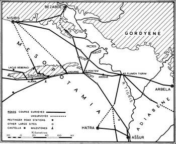
The question arises as to where exactly to locate ad flumen Tigrim. It should be stressed that the PT does not explicitly name or describe the precise location of ad flumen Tigrim. The only information given by the PT is that it was located 20 Roman miles (29.6 km) from Abdeae; it can thus most likely be identified as being near the modern village of Gonaisiya. However, given the distances from Sapham/Safan (the last identified point of the Melitene route) to ad Pontem/Tell Afar (the last definitively identified stop on the Zeugma route) and Abdeae/Gonaisiya (the last most likely identifiable location on the Zeugma route) – 118.5 km and 131.4 km, respectively (see Figure 2) – it appears that ad flumen Tigrim is extremely unlikely to be the same place in both itineraries. According to Oates (see Figure 1), from the Sinjar region one may reach several crossing points of the Tigris (Bezabde, Abu Dhahir, Abu Wajnam, Eski Mosul, and Mosul/Nineveh), although the most natural one, according to Oates, was ‘near Nineveh’. For all these directions, Oates was able to point to remains of roads which, in his times, could ‘be traced on the ground […] as a trough up to 20 metres wide and 5 metres deep’.Footnote 53 However, no such traces have been detected on modern satellite imagery.Footnote 54 In turn, Palermo has recently suggested Eski Mosul as the location of ad fl. Tigrim on this itinerary.Footnote 55 In this context, it is important to ask about any historical (besides sources directly mentioning Alexander's campaign), topographical, or archaeological data on crossing points of the Tigris in the times of Alexander the Great.
D. Oates’ map (Oates Reference Oates1956, Fig. 2) of the crossing points of the upper Tigris and Roman roads in northern Iraq

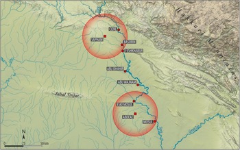
30 km buffers around Sapham/Safan and Abdeae/Gonaisiya

Historical, Topographical, and Archaeological Data on Crossing Points of the Upper Tigris in Antiquity
Alexander's crossing of the Tigris River has traditionally been suspected to have occurred at one of the following locations: Cizre, Feshkhabur, Abu Dhahir, Abu Wajnam, Eski Mosul, or Mosul/Nineveh (see Figure 2).Footnote 56 The latest comprehensive study on the road network in this part of the Middle East by Comfort and Marciak has investigated all potential crossing points of the Upper Tigris River in antiquity (c. 700 BCE to 636 CE) in south-eastern Turkey and northern Iraq.Footnote 57 In this context, it must be emphasised that the nature of the river crossings could actually vary significantly, including various modes (from fords to different types of ferries or bridges). And yet, the focus of the current paper should be on crossing the Tigris River by ford, as the Macedonian troops did in 331 BCE.
Cizre and Feshkhabur are located closest to Sapham/Safan.Footnote 58 Although the remains of (at least) three bridges have been reported in the vicinity of modern Cizre,Footnote 59 currently the remains of only two bridges appear to be extant – one located south of the medieval walls (considered to be Roman by Poidebard) and another bridge decorated with carvings of Zodiac features. The latter bridge is called Pihr-a-Bahfit on a British map dated to 1902 (of ‘Bohtan-Jezire’ with a scale of 1:250,000) and is dated on stylistic grounds to the second half of the twelfth century CE (and it is only a matter of speculation that it could have been built on a Roman predecessor).Footnote 60 This bridge, although now distant from the river, may once have been located directly over the Tigris, and its current curious location is apparently the result of changes to the course of the Tigris around Cizre.Footnote 61 What is more, a ford some 200 m to the south is also marked on the British map (but is useable only in the fall). Further downstream, a ford at Basorin (the village is currently called Yankale and is situated 2.5 km south of Bostancı in the Şırnak province) was used in 1836 by the English traveller J. Shiel.Footnote 62 In turn, the site of Feshkhabur, though frequently recalled in the context of the Gaugamela campaign, is in fact not likely the place where the river could have been forded in antiquity. A recent archaeological survey (the Eastern Ḫabur Archaeological Survey in 2016) has reported inconvenient topographical features – steep banks and a strong current. Furthermore, as of 2016 no ford has been known to local people in this area. Indeed, if the European travelogue literature of the nineteenth and early twentieth centuries is closely examined, it turns out that early European travellers to the region (especially W. F. Ainsworth and A. H. Layard) reported only the existence of a ferry at Feshkhabur.Footnote 63 Thus, it must be concluded that the crossing of the Tigris at Feshkhabur in antiquity never took place by ford.
Further south, two other locations very frequently suggested as potential crossing points of the Tigris (especially in the case of Alexander the Great) are Abu Dhahir and Abu Wajnam (both are now submerged under the waters of the Saddam Hussein/Eski Mosul Dam).Footnote 64 These locations can certainly be argued on topographical grounds – both places are suitably located where the terrain of the Mesopotamian plain allows direct access to the Tigris riverbed through an opening in the range of hills flanking the course of the southern bank of the river.Footnote 65 Likewise, archaeological data speaks in favour of these identifications through the extant remains of military forts controlling approaches to the river: Roman Seh Qubba for Abu Dhahir and the multi-layered site of Chamarash, recently discovered by the Land of Nineveh Archaeological Project, for Abu Wajnam (a bridge at Faida and two castella near Qabaq, once reported by Stein as Roman structures but no longer extant, could also have played this role on the east bank with regard to Abu Wajnam). The existence of the ford at Abu Wajnam is also explicitly stated by Kinneir, who travelled from Cizre via Zakho to Mosul in 1813,Footnote 66 while the ford at Abu Dhahir was reported by British excavators to have been still in use by the local population in the 1980s.Footnote 67
Eski Mosul (known as Balad or Shahrabadh before the Islamic period) has also been suggested as a crossing point in antiquity.Footnote 68 The only detailed examination of Eski Mosul in the context of travel infrastructure was conducted by Stein in 1939.Footnote 69 Unfortunately, it was not verified later by other scholars. Stein made the case for the use of the Eski Mosul crossing by ferry or pontoon bridge. The remains reported by Stein include an ancient pathway on the west bank, remains of the medieval bridge crossing the Wadi-al-Murr, and a nearby Roman castellum. The use of both Eski Mosul and Mosul as crossing points of the Tigris is mentioned by Al-Tabari (I, 2507) in the context of the Arab conquests of the region in 638–642 CE.Footnote 70
In turn, both Mosul (the site of medieval and modern settlement) and Nineveh (the site of the ancient city) are widely believed to have been located at an important crossing of the Tigris used for centuries in antiquity.Footnote 71 The existence of Late Roman and Sasanian fortresses apparently guarding approaches to the Tigris can possibly be inferred from both textual evidence (Arabic sources, Al-Tabari and Baladhuri referring to the beginning of Arab rule under ʿIyad ibn Ghānm in 638–640 CE and ibn-Farkad as-Sulami in 642 CE)Footnote 72 and isolated ceramic (Hellenistic pottery reported by Fiey)Footnote 73 and epigraphic finds (a lost Latin inscription from a Roman outpost some 3 km to the south of Mosul reported by KennedyFootnote 74). Indeed, Benjamin of Tudela confirms the existence of a bridge in Mosul, although only for the twelfth century CE.Footnote 75 It is, however, unclear if Mosul should be regarded as a convenient place for a ford.
GIS Simulations of Alexander's Itinerary
What emerges from our discussion so far is that, first, the Macedonian troops travelled from Thapsacus, most likely located at modern Belkis, Birecik, or Carchemish/Jerablus, towards a Tigris crossing located opposite the Gordyaean Mountains – that is, roughly between the modern cities of Cizre and Mosul. Second, it is clear that a number of crossing points of the Tigris existed in this area, though not all of them were fords. Furthermore, it is likely (though it cannot, of course, be proven) that the Macedonians were travelling along one of the ancient routes that was in use for centuries in northern Mesopotamia. With this assumption in mind, it may still be possible to bring new insights into Alexander's strategic situation in Mesopotamia if the available historical and archaeological data, presented above, is confronted with modern technology, especially the least cost path analysis used in Geographic Information Systems (GIS).Footnote 76
The least cost path is an approach that is used to determine the route between two points that accumulates the least cost (identified by cell attributes such as degree of slopes, land cover, presence of blockades, etc.).Footnote 77 Our analysis used a digital elevation model (DEM) as the basic data source obtained from the Shuttle Radar Topography Mission (SRTM). The DEM had a 100 m resolution and was augmented by topographic maps known as Tactical Pilotage Charts (TPC) at 1:500,000. We subsequently created a map displaying local land slopes on the basis of the DEM with slopes defined within the range of 74 intervals of one degree. The highest interval was rated 74 (indicating more cost), and the lowest was scored 1 (indicating less cost). Thus, our analysis was based on the cost understood as the degree of slopes. The aim of the use of the least cost path analysis is to suggest the length of probable routes between chosen locations in a more realistic way than through the use of the Euclidean metric, modern travel analogies, or pure guesswork.Footnote 78 In the second step, the results will be confronted with chronological data inferred from the historical sources to make a historical argument.
The results of our GIS analysis (see Tables 1–8) are relevant to several questions.
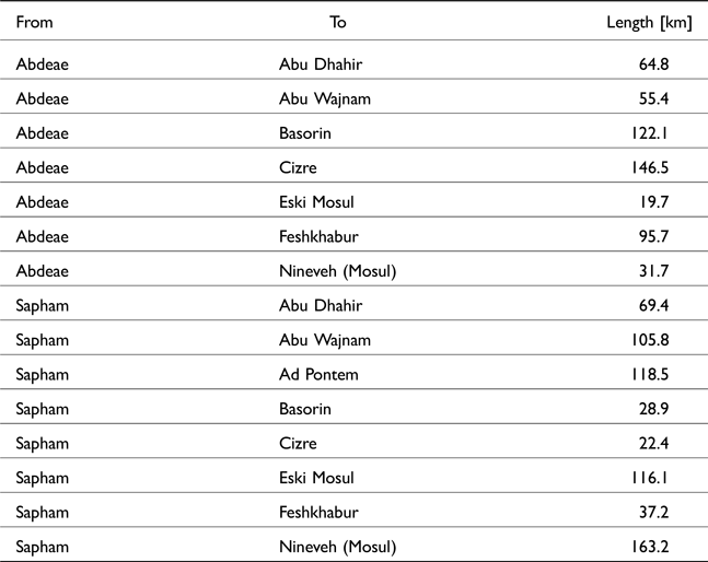
Length of final approaches (least cost paths) to the crossing points of the Tigris

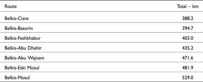
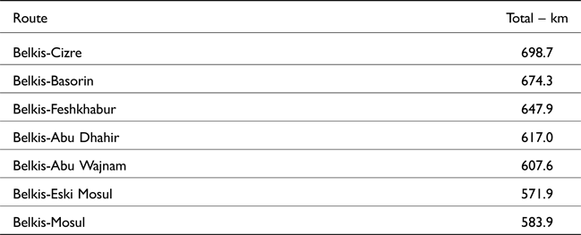
Routes and their lengths from Belkis to the crossing points of the Tigris (via the Zeugma Route until Nisibis, and next via Nisibis, Sarbane, and Sapham)

Routes and their lengths from Belkis to the crossing points of the Tigris via the Zeugma Route

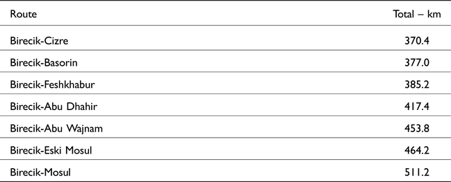
Routes and their lengths from Birecik to the crossing points of the Tigris (via the Zeugma Route until Nisibis, and next via Nisibis, Sarbane, and Sapham)

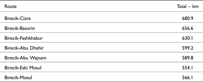
Routes and their lengths from Birecik to the crossing points of the Tigris via the Zeugma Route

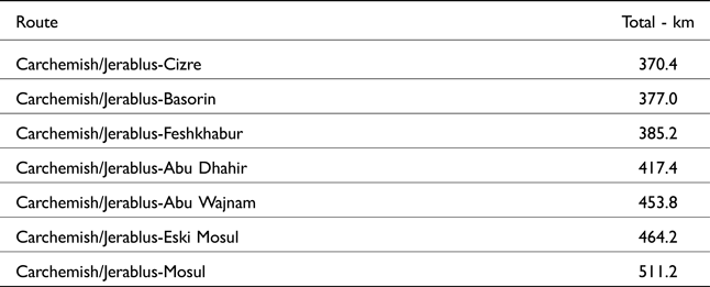
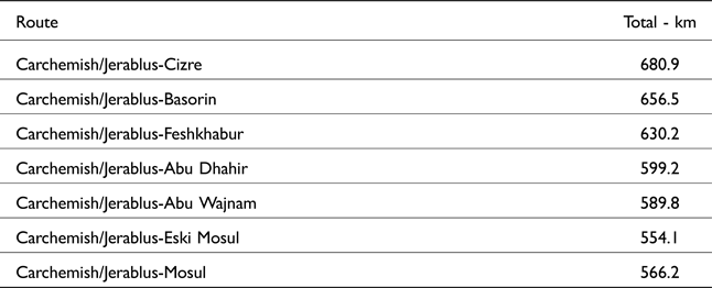
Routes and their lengths from Carchemish/Jerablus to the crossing points of the Tigris (via the Zeugma Route until Nisibis, and next via Nisibis, Sarbane, and Sapham)

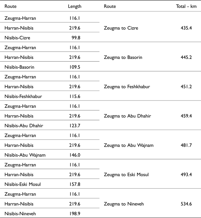
Routes and their lengths from Carchemish/Jerablus to the crossing points of the Tigris via the Zeugma Route until Nisibis

Marsden's routes and their lengths using the least cost path calculations

First, as noted above, the site of ad flumen Tigrim on the route from Zeugma and on the route from Melitene cannot be the same, as the distances from Sapham/Safan to ad Pontem/Tell Afar and Abdeae/Gonaisiya are 118.5 km and 131.4 km, respectively.
Second, if the distance to the Tigris crossing from the Zeugma route is used as representative for both routes (approximately 30 km), then the buffering analysis indicates which crossing points of the Tigris come into play for Sapham/Safan and Abdeae/Gonaisiya within a 30 km range (see Figure 2): Cizre and Basorin for Sapham/Safan (Feshkhabur falls short of only 2 km to be within the expected range), and Eski Mosul and Mosul for Abdeae/Gonaisiya.
However, the results of the imperfect buffering analysis (using the Euclidean metric) can be confronted with the least cost path analysis to yield the results for the relevant routes (see Table 1). In this light, Cizre and Basorin can be suggested as the most convenient crossing points of the Tigris for travellers from Sapham/Safan (22.4 km and 28.9 km distant, respectively), while Mosul and Eski Mosul can be suggested for Abdeae/Gonaisiya (both southern locations for quite different reasons: Mosul being almost the right distance as indicated by the PT at 31.7 km, and Eski Mosul being within easy reach at 19.7 km).Footnote 79
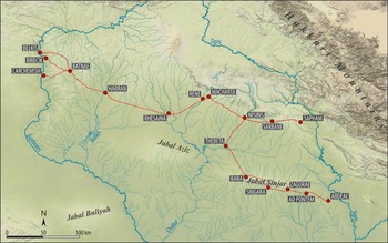
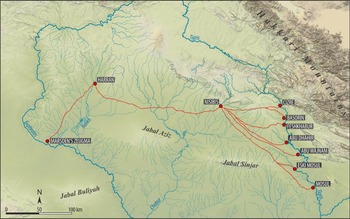
Third, the simulations of the total distances covered by the Macedonian troops based on the least cost path analysis have been conducted depending on the identification of Zeugma (three possible locations: Belkis, Birecik or Carchemish/Jerablus), the route used (two variants: via the Zeugma Route until Nisibis, then via Sarbane and Sapham; or all the way via the Zeugma route) and the destination (possible crossing points of the Tigris: Cizre, Basorin, Feshkhabur, Abu Dhahir, and Abu Wajnam for the first route variant; Abu Dhahir, Abu Wajnam, Eski Mosul, and Mosul for the second route variant). It should be stressed that our results (see Tables 2–7 and Figure 3) indicate considerably longer distances than those once estimated by Marsden, who counted the following distances covered by the Macedonians from Zeugma: 308 km to Cizre, 308 [sic] km to Abu Dhahir, 328 km to Abu Wajnam, and 371 km to Mosul.Footnote 80 Marsden's calculations differed not only because of a different starting point (the southern location), but also because it included fewer stopping points along the way (only Harran and Nisibis).Footnote 81 Ultimately, the method itself, which relied on straight-line measurements (with adjustments), was wrong; the least cost path simulations for the exact itineraries as suggested by Marsden (his starting point and only two stopping places at Harran and Nisibis) give much longer distances (see Table 8 and Figure 4): 435 km to Cizre, 459.4 km to Abu Dhahir, 481.7 km to Abu Wajnam, and 534.6 km to Mosul.
The least cost paths from various identifications of Zeugma to Abdeae/Gonaisiya and to the Nisibis, Sarbane, and Sapham route

Simulation of the least cost paths on Marsden's reconstruction of Alexander the Great's itinerary from Marsden's location of Zeugma to various crossing points of the Tigris

Chronology and Itinerary of the March of the Macedonian Troops
In this context, it should be remembered that while the date of the Tigris crossing is well known – September 18, 331 BCE (thanks to references in Curt. 4.10.2 and the cuneiform sources)Footnote 82 – the date of the Euphrates crossing given by Arrian (Anab. 3.7.1) is less clear and has been disputed. Namely, Arrian's reference can be translated into the period between July 10 and August 9, 331 BCE,Footnote 83 which is of course not very precise. What is more, the dating of the Euphrates crossing bears on the scholarly interpretation of the strategic situation of the Macedonian troops in summer. Two divergent interpretations have been best embodied by Bosworth and Marsden.Footnote 84 According to Bosworth,Footnote 85 Alexander was in a hurry on his entire march in Mesopotamia. Consequently, Bosworth suspects that Arrian's reference is a month too early, perhaps because much too precise a date is given for a general reference to midsummer in his sources. In contrast, Marsden thinks that Alexander was making strategic decisions (including the directions of the march) without haste, much to Darius’ confusion.Footnote 86 Plutarch's recounting of the episode of the mock battle between the Macedonian soldiers on their march through Mesopotamia aptly illustrates the relaxed atmosphere and lack of hurry during their entire march through Mesopotamia. While the approximate amount of time spent by the Macedonians in Mesopotamia in 331 BCE and the probable distance covered by Alexander's troops have been used by Marsden to suggest several options for the average marching rate of the Macedonians,Footnote 87 their average marching rate has been thoroughly studied by Engels on the basis of all the data concerning Philip II's and Alexander's troops and was determined to be 24 km per day.Footnote 88
If the average rate estimated by Engels is used to estimate the possible amount of time spent in Mesopotamia, then we get the following number of days spent by the Macedonians in Mesopotamia depending on their destination:
– Cizre: 16.2 (from Belkis via Nisibis, Sarbane, and Sapham) and 15.4 days (from Birecik via Nisibis, Sarbane, and Sapham);
– Basorin: 16.4 (from Belkis via Nisibis, Sarbane, and Sapham) and 15.7 days (Basorin from Birecik via Nisibis, Sarbane, and Sapham);
– Feshkhabur: 16.8 (from Belkis via Nisibis, Sarbane, and Sapham) and 16.0 days (from Birecik via Nisibis, Sarbane, and Sapham);
– Abu Dhahir: 18.1 (from Belkis via Nisibis, Sarbane, and Sapham), 25.7 (from Belkis via the Zeugma route), 17.4 (from Birecik or Carchemish/Jerablus via Nisibis, Sarbane, and Sapham), and 24.9 days (from Birecik or Carchemish/Jerablus via the Zeugma route);
– Abu Wajnam: 19.6 (from Belkis via Nisibis, Sarbane, and Sapham), 25.3 (from Belkis via the Zeugma route), 18.9 (from Birecik or Carchemish/Jerablus via Nisibis, Sarbane, and Sapham), and 24.6 days (from Birecik or Carchemish/Jerablus via the Zeugma route);
– Eski Mosul: 20.1 (from Belkis via Nisibis, Sarbane, and Sapham), 23.8 (from Belkis via the Zeugma route), 19.3 (from Birecik and Carchemish/Jerablus via Nisibis, Sarbane, and Sapham), and 23.1 days (from Birecik or Carchemish/Jerablus via the Zeugma route);
– Mosul: 22 (from Belkis via Nisibis, Sarbane, and Sapham), 24.3 (from Belkis via the Zeugma route), 21.3 (from Birecik or Carchemish/Jerablus via Nisibis, Sarbane, and Sapham), and 23.6 days (from Birecik or Carchemish/Jerablus via the Zeugma route).
Thus, the length of march through Mesopotamia must have taken between 16 (15.4) and 26 (25.7) days if the Macedonians travelled at an average speed. Furthermore, it becomes clear that the fastest routes led via Nisibis, Sarbane, and Sapham to Cizre, Basorin, and Feshkhabur (16–17 days). The second fastest routes led to Abu Dhahir and Abu Wajnam via Nisibis, Sarbane, and Sapham (18–20 days), followed by routes to Eski Mosul and Mosul by the same route (20–21 days). Travel via the Zeugma route all the way via Abdeae was more time-consuming – it required about 24–25 days to get to Eski Mosul or Mosul and 25–26 days to reach Abu Dhahir or Abu Wajnam. It follows that if Engel's data on Macedonian marching rates is used, there remains no option but to accept Bosworth's suggestion that the date of the Euphrates crossing should be a month later and the Macedonians crossed the Euphrates after August 10 (close to August 23) and before September 2, 331 BCE. This date as the beginning of the Gaugamela campaign could also be well understood in terms of the strategic considerations plainly presented by Arrian – in this way, the Macedonians avoided much of the two hottest months in northern Mesopotamia, July and August.
In contrast, if Marsden's average marching rate is used (being 11.3 km, calculated from 4.5 m [7.2 km] as the slowest marching rate and 9.5 m [12.7 km] as the fastest marching rate), then it would take the following number of days to reach the following destinations:
– Cizre: 34.3 (from Belkis via Nisibis, Sarbane, and Sapham) and 32.8 days (from Birecik via Nisibis, Sarbane, and Sapham);
– Basorin: 34.9 (from Belkis via Nisibis, Sarbane, and Sapham) and 33.4 days (from Birecik via Nisibis, Sarbane, and Sapham);
– Feshkhabur: 35.7 (from Belkis via Nisibis, Sarbane, and Sapham) and 34.1 days (from Birecik via Nisibis, Sarbane, and Sapham);
– Abu Dhahir: 38.5 (from Belkis via Nisibis, Sarbane, and Sapham), 54.6 (from Belkis all the way via the Zeugma route), 36.9 (from Birecik and Carchemish/Jerablus via Nisibis, Sarbane, and Sapham), and 53 days (from Birecik and Carchemish/Jerablus all the way via the Zeugma route);
– Abu Wajnam: 41.7 (from Belkis via Nisibis, Sarbane, and Sapham), 53.8 (from Belkis all the way via the Zeugma route), 40.1 (from Birecik and Carchemish/Jerablus via Nisibis, Sarbane, and Sapham), and 52.2 days (from Birecik and Carchemish/Jerablus all the way via the Zeugma route);
– Eski Mosul: 42.6 (from Belkis via Nisibis, Sarbane, and Sapham), 50.6 (from Belkis all the way via the Zeugma route), 41.1 (from Birecik and Carchemish/Jerablus via Nisibis, Sarbane, and Sapham), and 49.1 days (from Birecik and Carchemish/Jerablus all the way via the Zeugma route);
– Mosul: 46.8 (from Belkis via Nisibis, Sarbane, and Sapham), 51.7 (from Belkis all the way via the Zeugma route), 45.2 (from Birecik and Carchemish/Jerablus via Nisibis, Sarbane, and Sapham), 50 (from Birecik all the way via the Zeugma route) and 50.1 days (from Carchemish/Jerablus all the way via the Zeugma route).
If Marsden's calculation of the Macedonian average marching rate is used, Arrian's date can indeed be accepted (but much closer to August 9 than to July 10). However, it should be noted that Marsden's calculation implies a very slow average marching rate (and as such is very controversial given everything we know about Macedonian logistic capabilities) and can only be accepted if Plutarch's episode is judged as representative for most of the Macedonians’ itinerary in Mesopotamia. This in turn could only be possible without any external pressure like that exercised by Mazaeus’ troops. However, given the cumulative evidence of Curtius, Arrian, and Diodorus (see above), the marching rate suggested by Marsden and his reconstruction of a slow, peaceful march of the Macedonian army through Mesopotamia is very unlikely.Footnote 89
In summary, the general geographical context of the itinerary of the Macedonian army in Mesopotamia can be inferred from our literary sources: the Macedonian troops marched from Thapsacus on the Euphrates towards a Tigris crossing located opposite the Gordyaean Mountains – that is, roughly between the modern cities of Cizre and Mosul. The probable itinerary of the Macedonian troops may also be reasonably approximated on the basis of our knowledge of ancient routes in northern Mesopotamia, especially the Persian royal road and the Peutinger Table. In this context, it seems most likely that the Macedonian itinerary led across the Tur Abdin to the vicinity of modern Nisibis and further eastwards to a Tigris crossing.Footnote 90 Such a march, depending on the location of the Tigris crossing between Cizre and Mosul (also assuming the location of Thapsacus at Belkis, Birecik, or Carchemish/Jerablus), involved distances of between 370.4 km and 617 km. Given the average marching rate of the Macedonian troops (estimated by Engels as 24 km per day), these distances could be covered within 16 to 26 days. Given the definitively dated crossing of the Tigris to September 18, 331, the Macedonians must have started their march between August 23 and September 2, which agrees with Bosworth's postulated correction of Arrian's reference in 3.7.1. It also fits the logistic considerations pointed out by Arrian at Anab. 3.7.3: beginning the campaign late saved the Macedonians from experiencing most of the hottest season of July and August in northern Mesopotamia. It also appears that the Macedonian marching rate must have been faster than average for both logistic and military reasons. Concerning logistics, an effective march would have brought the Macedonians faster out of the Mesopotamian desert, which was marked by higher temperatures and potentially lower food supplies. Concerning military considerations, all of our sources except Plutarch suggest the continuous presence of Achaemenid scouting troops along the Macedonian march. What is more, both Curtius and Diodorus suggest that the Achaemenid troops took on an intensive scorched-earth policy. In this scenario, it appears that we should be inclined to see the Macedonians as moving faster and tending towards shorter distances to the Tigris crossing. This in turn suggests that the crossing point of the Tigris should be sought more upstream than downstream, which, given the topographic and archaeological data on crossing points of the Upper Tigris, points to the vicinity of modern Cizre and Basorin.Footnote 91 This identification is further supported by the fact that the two fords are located on the route that appears to have been in use in Persian times as the Achaemenid royal road. If so, we can be even more precise – the distance covered by the Macedonians was between 370 km and 394 km and could in fact be covered within 16 days or even slightly faster. It follows that the Euphrates was crossed by the Macedonians around September 2, 331 BCE.
Acknowledgements
This paper presents a selected aspect of research conducted within the project entitled ‘Location of the Battle of Gaugamela in the Light of Multidisciplinary Research’ (no. 2017/26/M/HS3/00750), which is financed by the National Science Centre in Poland. The project is affiliated at Jagiellonian University in Poland and is conducted in cooperation with the Land of Nineveh Archaeological Project of the University of Udine (Prof. Daniele Morandi Bonacossi). We wish to thank the two anonymous reviewers of this paper for their very helpful feedback. We also extend our thanks to Dr. Piotr Głogowski (University of Wrocław, Poland) and Mr. Nils Fischer, MA (University of Bonn, Germany) for their editorial and bibliographical help during the revision process.