Introduction
The presence and operation of scientific stations and bases in Antarctica has impacted the environment, whether it be through the construction and ultimate destruction of infrastructure such as buildings, the deliberate or inadvertent dispersal of rubbish, fuel and chemicals at and away from the stations or the deliberate or accidental modification of the environment by administrators, trades staff, researchers, tourists and other visitors. Environmental practices implemented by most modern Antarctic programmes should minimize human impacts on the environment, although many impacts still occur. For example, dispersal of rubbish from field activities (Kiernan & McConnell Reference Kiernan and McConnell2001) and the construction and operation of bases during periods of strong wind is a common but underreported process, as most bases are located on the coast and the strongest winds blow offshore, carrying debris out to sea. Similarly, impacts resulting from field-based research activities can also occur, and these are gaining greater attention (e.g. Kiernan & McConnell Reference Kiernan and McConnell2001, Ayres et al. Reference Ayres, Nkem, Wall, Adams, Broos and Parsons2008, O'Neill et al. Reference O'Neill, Balks and López-Martίnez2013, Peter et al. Reference Peter, Braun, Janowski, Nordt, Nordt and Stelter2013, Brooks et al. Reference Brooks, Jabour and Bergstrom2018). Environmental guidelines (directed by the Protocol on Environmental Protection to the Antarctic Treaty; Madrid Protocol 1991) have been developed by Pertierra et al. (Reference Pertierra, Hughes, Benayas, Justel and Quesada2013a) to help reduce these impacts to the extent that this is practically possible.
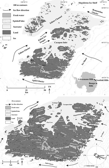
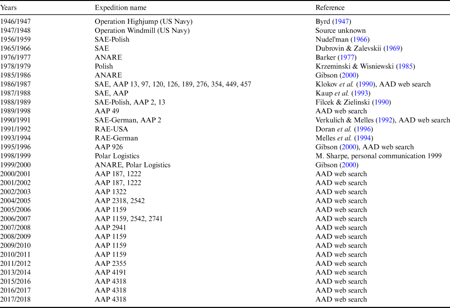
Studying the effects of human activities associated with Antarctic bases on the natural environment is often confounded by continued habitation, which can play both positive (e.g. regular clean-ups) and negative (e.g. acceptance of negative environmental impacts due to familiarity) roles. Bunger Hills in East Antarctica (Fig. 1) provides a rare example in which the effects of human habitation in an area can be studied without the presence of a permanently occupied base. The area has been visited over the last 60 years at low levels relative to other areas of East Antarctica (Table I), with three scientific stations built between 1956 and 1987 that are usually occupied only occasionally. The main periods of activity in the Bunger Hills were in the 1950s, when one of the stations was occupied continually for several years, and in the late 1980s to the early 1990s, when regular summer visits were made to the area. More recently, the commencement of Australian intracontinental flights has allowed more frequent but generally short summer visits by small parties (Table I). The locations of the stations in Bunger Hills also aid in studying human impacts, in that none are near the open coast and therefore much of the rubbish blown away from the stations is retained locally on the land.
Bunger Hills, showing locations of Oasis-2 and Dobrowolski stations, Edgeworth David Base and places mentioned in the text. The inset at the lower right shows the wind rose of three-hourly wind azimuth measurements recorded at Edgeworth David Base in January–March 1986. D = Dobrowolski Station, ED = Edgeworth David Base, O = Oasis-2 Station.

Visits to Bunger Hills (excluding short stops to refuel aircraft or maintain equipment) until 2017. Other visits were most probably made from Mirny Station between 1958 and 1975. Visits were up to four months in duration over summer, except for occupation of Oasis Station (1956–1959). Where known, the project number is given. Australian trips since 1986 are available from https://secure3.aad.gov.au/public/projects/.

AAD = Australian Antarctic Division, AAP = Australian Antarctic Program, ANARE = Australian National Antarctic Research Expeditions, Polar Logistics = a private company based in the UK, now Antarctic Logistics (https://antarctic-logistics.com), RAE = Russian Antarctic expeditions, SAE = Soviet Antarctic expeditions.
In this article, we catalogue substantial periods of human visitation and the resultant impacts on the environment. Our aim is not to identify national programmes that might have contributed to any impacts; instead, we strive to understand the mechanisms by which these impacts occur and, through their identification, provide suggestions as to how environmental damage both in the Bunger Hills and elsewhere in Antarctica can be reduced.
Bunger Hills description and occupation history
Bunger Hills, with an area of 952 km2, is the second largest ice-free oasis on the coastline of East Antarctica, after Amery Oasis (Fig. 1). The hills are completely surrounded by ice: to the east lie the ice sheet and Remenchus Glacier, to the south Apfel Glacier, to the west Scott and Edisto glaciers and to the north Shackleton Ice Shelf. Over 400 km2 of the oasis is taken up by Cacapon Inlet, an area of marine water isolated (at least at the surface) from the Southern Ocean by the floating Shackleton Ice Shelf. Bunger Hills sensu stricto consists of a series of rugged but low-relief islands, nunataks and peninsulas. The largest continuous area of land is the southern portion, which is c. 30 km × 20 km and has an area of 262 km2 (Fig. 1). This area contains numerous lakes, including Algae Lake, one of the largest freshwater lakes in Antarctica (Klokov et al. Reference Klokov, Kaup, Zierath and Haendel1990), and an extensive terrestrial drainage system that is the third longest known in Antarctica (Gibson et al. Reference Gibson, Gore and Kaup2002). Vertebrate biota of Bunger Hills are limited to four bird species - Wilson's storm petrel (Oceanites oceanicus), snow petrel (Pagodroma nivea) and south polar skua (Catharacta maccormicki), which all breed in the area, as well as occasional visits by Adélie penguins (Pygoscelis adeliae). An apparently isolated population of Weddell seals (Leptonychotes weddellii) occurs in the marine portion of Bunger Hills (Leishman et al. Reference Leishman, Gibson and Gore2020). Numerous species of lichens and mosses have been recorded from the area, especially along the southern ice edge alongside Apfel Glacier (Gibson Reference Gibson2000, Leishman et al. Reference Leishman, Gibson and Gore2020).
Bunger Hills was first sighted from a considerable distance by members of the Australasian Antarctic Expedition's Western Party in November 1912, who believed the area to consist of two islands. Heavy crevassing on the intervening glaciers precluded a ground visit. The full extent of the ice-free area was first recognized in January 1947 by members of Operation Highjump, and a seaplane landing was made in the following month. Byrd (Reference Byrd1947) described the area as ‘…one of the most remarkable regions on earth. A place suitable for life had been found in a universe of death.’ A further short visit was made in January 1948 as part of Operation Windmill (Alberts & Blodgett Reference Alberts and Blodgett1956).
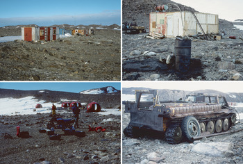
The next visitors were members of the 1st Soviet Antarctic Expedition, who explored the area from 22 to 30 January 1956 (Avsyuk et al. Reference Avsyuk, Markov and Shumsky1956, Nudel'man Reference Nudel'man1966). These initial observations convinced the Soviet authorities to develop a scientific station in the region, with the aim of determining the conditions that resulted in the area being ice-free. The first loads of cargo were flown from Mirny from 5 to 13 April 1956, and construction of the station was completed by the middle of October. Oasis (transliterated as Oazis or Oasis) Station (Figs 1 & 2) was inaugurated on 15 October 1956, when it consisted of three wooden buildings. Groups of scientists were flown in from Mirny, and the base was continually occupied until 17 November 1958, when it was closed (Table I).
Top left. Oasis-2 Station (66°16'28.59''S, 100°45'1.40''E). Top right. Part of Dobrowolski Station, surrounded by rubbish and stacked equipment. The drum in the foreground was used for open burning (66°16'24.74''S, 100°44'43.28''E). Bottom left. The four remaining huts comprising Edgeworth David Base (66°15'0.33''S, 100°36'7.45''E). Bottom right. Damaged and rusted vezdekhod vehicle (from the rear) at Oasis Station (66°16'23.64''S, 100°44'41.13''E).

At the end of 1958, Oasis Station was transferred to the Polish Academy of Sciences for the continuation of scientific investigations (Nudel'man Reference Nudel'man1966). The first group of Polish expeditioners reached Oasis Station (via Mirny) in mid-January 1959, and the official transfer took place on 23 January 1959. The station was renamed Dobrowolski, in honour of the Polish scientist, Antoni Bøleslaw Dobrowolski, who had wintered with Gerlache's Belgian expedition of 1897–1899. Dobrowolski Station was temporarily closed on 30 January 1959, with the intention that the party would return in the following summer. However, the next official Polish expedition did not take place for 20 years. In the interim, occasional visits were made by Russian scientists from Mirny. A short visit was also made by Australian expeditioners in March 1977, when an inspection of Dobrowolski Station concluded that it was in excellent condition considering its age (Barker Reference Barker1977). Interest in Polish polar research was rekindled in the mid-1970s, which led to a group of scientists visiting Dobrowolski from 18 January to 21 February 1979. The station was reported to be ‘in good condition,’ even though it ‘had not been used for 20 years’ (Krzeminski & Wisniewski Reference Krzeminski and Wisniewski1985). A clean-up of the station environs was made at this time.
Russian interest in Bunger Hills was renewed during this period. Plans were made in 1985 for the construction of a new station in Bunger Hills (Shabad Reference Shabad1985), which was built in the 1986/1987 summer and opened in early 1987 (Filcek & Zielinski Reference Filcek and Zielinski1990). The station, named Oasis-2, consists of six wooden and metal-clad buildings situated near the shore of Algae Lake a few hundred metres to the west of Dobrowolski Station. Regular summer visits of up to four months in duration were made to the station between 1986/1987 and 1993/1994, with Polish, German and American scientists joining the Russians.
The initial Australian visit resulted in the development of a research programme in Bunger Hills, and a new summer field base, Edgeworth David, was officially opened on 8 February 1986. This base consisted of three prefabricated fibreglass ‘apple’ huts and two slightly longer ‘melon’ huts (Fig. 2) close to the shore of Transkriptsii Gulf. An additional apple hut being transported as a helicopter sling load from MV Nella Dan to Edgeworth David Base was dropped accidentally and smashed somewhere over the ice shelf or Edisto Ice Tongue during the establishment of the base. Aircraft operations during this season created small spills of fuel and oil that soaked to 30 cm depth into the sediment near the huts. Sampling and analyses a decade later (Gore et al. Reference Gore, Revill and Guille1999) demonstrated very little change to the oil and only a little change to the kerosene, confirming long-term persistence of both products in the sediment. One of the apple huts has since disappeared while the base was unoccupied, and the presence of wire guy ropes still in the ground and characteristic, bright red fibreglass shards spread downwind confirm that the hut had blown away between 1988 (when Australian explorer Dick Smith visited and photographed it) and November 1995, when two of the authors (DBG, MRL) visited and found the hut to be missing. Edgeworth David Base has been occupied intermittently by Australian and other visitors since its establishment (Table I), and other short Australian visits have been made to refuel helicopters or fixed-wing aircraft en route between Davis and Casey stations (Gibson Reference Gibson2000).
The winds at Bunger Hills are similar to those of other rocky oases of the East Antarctic coastline (Table II). The modal wind direction is from the east, and this is also the direction of the greatest recorded wind speed, at 56 m s−1. Winds of > 15 m s−1 were recorded on 122 days of the year. Measurements recorded at Edgeworth David Base in January–March 1986 (AAD 2018, Gore & Leishman Reference Gore and Leishman2020) and for 18 months in 2000–2001 near White Smoke Lake, at the southern margin of Bunger Hills near Apfel Glacier (Fig. 1), were in general agreement with the earlier data (Doran et al. Reference Doran, McKay, Meyer, Andersen, Wharton and Hastings1996).
Summary of wind conditions at Oasis Station, November 1956–October 1958.

Data from Nudel'man (Reference Nudel'man1966) and Gregorczuk (Reference Gregorczuk1980).
Methods
All Universal Transverse Mercator 1 km grid squares in southern Bunger Hills were traversed on foot during the 1995/1996 summer, with c. 60% revisited during January 2000. All observed anthropogenic items, vehicular tracks and paint marks were recorded, and their locations noted within 30 m using handheld global positioning systems. Items were categorized into ‘in situ’ or ‘ex situ’ depending on whether the item remained where it had been placed or formed (‘in situ’; e.g. route markers, vehicular tracks) or had been transported from elsewhere by wind (‘ex situ’; e.g. fibreglass shards, timber fragments). After mapping, as much rubbish as possible was collected and shipped to Australia for disposal. Chemicals spilling from rusted drums at Oasis Station were examined for their mineralogy. Samples were placed in plastic Petri dishes, sealed with tape to prevent desiccation or hydration and stored at ambient temperature until analysis. Samples were hand-milled under acetone in an agate mortar and pestle to fine powders before mounting on silicon crystal low-background holders. Analyses were performed using a Philips PW 1404 X-ray diffractometer using copper Kα radiation from 5° to 85°2θ in 0.05° steps, and with tube power settings of 40 kV and 40 mA. Diffractograms were analysed using PANalytical HighScore+ software v. 2.2.1 with the 2013 International Centre for Diffraction Data Powder Diffraction File 2 inorganic mineralogical database and the FIZ Karlsruhe GmbH Inorganic Crystal Structure Database.
Results
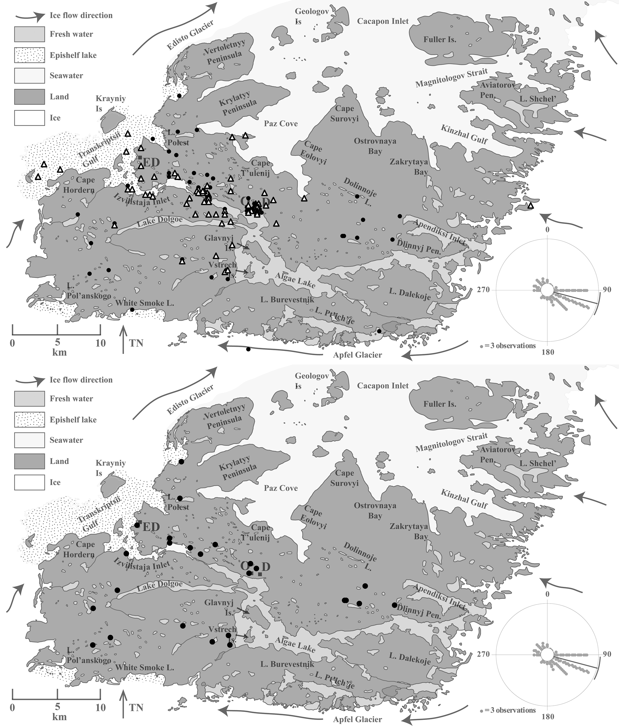
Traces of human presence were found throughout southern Bunger Hills (Figs 3–6 & Table SI), with impacts identifiable from all phases of habitation of the area. Impacts could be separated into two categories; in situ, where the material was placed or discarded; or ex situ, where the material had been blown to its recorded position by strong wind. Items that were located in situ were in general distributed across the hills. For example, ground disturbances were widespread, with prominent tracks made by vehicles along the valleys connecting Oasis Station, Cacapon Inlet and Transkriptsii Gulf. These and other routes were marked with empty gas cylinders, emplaced as navigation aids in case of poor visibility from blowing snow. As recently as 1992, transport within the hills was in part by Russian steel-tracked personnel- and cargo-carrying all-terrain vehicles (vezdekhod; Fig. 2) (D. Andersen, personal communication 1999), and therefore tracks could appear between the station, Transkriptsii Gulf where aircraft land and on common navigable routes to wherever research had been undertaken, such as White Smoke Lake (Figs 1 & 4). Significant disturbance was also recorded in the immediate area of Edgeworth David Base, where the flow lines of a number of minor streams had been diverted by hand-digging shallow trenches to route water away from the huts and areas cleared of boulders for helicopters to land.
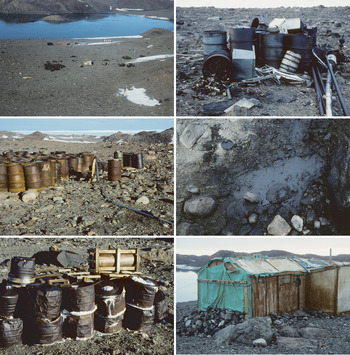
Top left. Oasis/Dobrowolski showing derelict equipment and rubbish (66°16'25.89''S, 100°44'42.02''E). Top right. Glass and metal stockpiled in open drums; some have tipped over, spilling their contents (66°16'24.80''S, 100°44'43.81''E). Middle left. 200 l fuel drums, leaking fuel line and diesel-soaked sediment (66°16'24.38''S, 100°44'55.67''E). Middle right. Engine oil on the ground (lens cap = 75 mm diameter) (66°16'24.02''S, 100°44'40.62''E). Bottom left. Rusted drums leaking table salt and sodium bicarbonate, which was probably used as washing powder (66°16'25.53''S, 100°44'37.56''E). Bottom right. Derelict buildings forming Oasis Station. Canvas sheeting protecting the interior from snow ingress reflects the parlous state of the building (66°16'28.67''S, 100°45'0.31''E).

Distribution of rubbish and impacts in southern Bunger Hills. The inset shows the wind rose recorded at Edgeworth David Base in 1986. Some items were wind dispersed after use off-station, accounting for some light items upwind of human habitation. Top. All rubbish and impacts displayed as in situ (closed circles) or ex situ (open triangles), as defined in the text. Bottom. Disturbed ground. This map represents locations of soft sedimentary substrates along popular navigable routes that have been disturbed by human activities such as driving vehicles. D = Dobrowolski Station, ED = Edgeworth David Base, O = Oasis-2 Station.

Top. Distribution of fuel drums, which are mainly downwind of expedition activities. Bottom. Gas cylinders, which are either near to Oasis-2 Station or mark navigable routes for overland vehicles. D = Dobrowolski Station, ED = Edgeworth David Base, O = Oasis-2 Station.

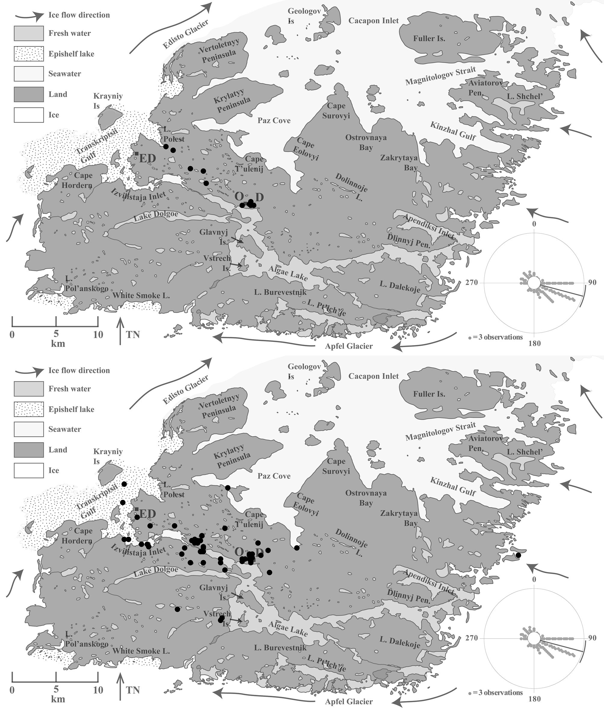
Top. Distribution of paper and plastic. Bottom. Distribution of wood and sheeting, including plywood and fibreglass. D = Dobrowolski Station, ED = Edgeworth David Base, O = Oasis-2 Station.

Many items were found that had been put in place for scientific or logistical purposes. An unserviceable boat was positioned next to Lake Polest (Figs 1 & 4), and a shovel had been left nearby where a shoreline had been sampled. Large writing had been painted on rocks in a number of places adjacent to where mumiyo (a proventricular oil ejected by snow petrels as a defence mechanism from avian predators) had been sampled for radiometric dating. An abandoned pluviometer remains in the south-west of the hills.
Ex situ debris, including empty fuel drums (Fig. 5), wood, plastic, fibreglass (shards from one of the apple huts from Edgeworth David Base, and a broken fibreglass dinghy at the outlet from Algae Lake; Fig. 6) and smaller pieces of metal, were distributed mostly in a narrow zone downwind, to the WNW of Oasis and Dobrowolski stations and Edgeworth David Base. Most of the windblown debris from Oasis and Dobrowolski stations travelled along the northern side of Algae Lake and through the narrow gorge that connects Algae Lake to Izvilistaya Inlet, and Transkriptsii Gulf (Figs 1 & 4–6).
Some of the impacts of human habitation in Bunger Hills are cryptic because they have soaked into the sediment. Fuel spills, apparent at Dobrowolski Station, Oasis Station and Edgeworth David Base, were probably caused during the refuelling or repair of aircraft, vehicles or other equipment. Heavy lubricating oil was found ponded on the ground surface at Oasis Station (Fig. 3).
Broken lead-acid vehicle batteries and other chemicals found around the Oasis-Dobrowolski region (Fig. 3) could contaminate Algae Lake with metals, notably iron and lead. Hundreds of empty steel fuel drums, gas cylinders, derelict equipment, shallow soil pits part-filled with human hair, plastic burnt on the soil surface and a barbeque drum are all sources of inorganic and organic contamination of the environment. X-ray diffractometry of three subsamples of white chemicals leaking from 12 rusted and split steel drums (Fig. 3) revealed a mixture of the minerals - halite (NaCl), trona (sodium hydrogen bis(carbonate) dihydrate) (Na3(CO3)(HCO3)·2(H2O)) and sodium sulfate (Na2SO4) - that was probably used as washing powder.
Pollution of lakes, whether by chemicals or due to capture of rubbish, was not assessed in this study. However, one of the steel-tracked vezdekhod vehicles is known to have been submerged in Lake Polest. The chemical and physical impacts of this event are unknown; the vehicle was subsequently recovered and restarted, and it is now probably one of the two derelict, rusted vezdekhod at Oasis Station. Further impacts may accrue from a Russian plane dating from the early 1960s that lies at a depth of c. 12 m in Algae Lake close to Oasis Station (D. Andersen, personal communication 1999).
Discussion
There is a widespread distribution of physical impacts (e.g. by steel-tracked vehicles on soft sediment shorelines) and in situ debris that occurs as a consequence of station operation (e.g. gas bottles as trail markers), carelessness (e.g. broken and abandoned boats), laziness (e.g. discarded wire rope winches) or vandalism (e.g. most of the broken glass, much of which is derived from bottles smashed on the ground). At least these impacts are immobile, and they are unlikely to occur in modern times as a result of better expeditioner training and attitudes. However, the obvious impacts of national expeditions and scientific research at Bunger Hills are exemplars of what has happened at many areas studied since the 1957/1958 International Polar Year. All areas will be affected to a greater or lesser degree, no matter how stringent the environmental protections set in place. However, Bunger Hills shows the effects of particularly insensitive activity and ineffective protection.
In contrast, ex situ (windblown) debris is most abundant downwind of the research stations and bases, and it has been found kilometres downwind and even on the edge of the Edisto Ice Tongue (Fig. 1). The strongest winds and most prevalent winds are from the east (Gore & Leishman Reference Gore and Leishman2020), causing lighter debris to be blown by the wind from areas of expeditioner operations to their current locations.
Perhaps of greatest obvious concern is the actual and potential loss of huts. Huts retain their integrity as long as winds cannot penetrate them, but when strong winds gain ingress the structures can fail with large-scale dispersal of debris from the hut and its contents. Conspicuous red fibreglass shards confirm the destruction of one apple hut at Edgeworth David Base, but the fate of its contents (if any) are unknown. The loss of this hut occurred within 10 years of its installation at Edgeworth David Base. Fibreglass huts suffer from abrasion by sand and ice on their upwind sides, which is particularly pronounced where the sediment is sandy. The huts at Edgeworth David Base have upwind edges where the fibreglass has been abraded thin. Spindrift (a fine, windblown snow) was observed in early 1996 to gain entry through some of the fibreglass apple hut walls, demonstrating how thin they had become from abrasion by blowing sand. Emergency fibreglass reinforcement was made to several of these huts in early 1996, but given how rapidly this erosion has occurred (the huts were new in 1985) they should be checked for maintenance requirements at least every five years. The same concerns exist for the older huts at Oasis/Dobrowolski, where emergency repairs made of canvas lie in tatters (Fig. 3), confirming the parlous state of some of the structures. Once these huts disintegrate - and the same principle holds of field structures anywhere in Antarctica - then large masses of debris will be available for dispersal by strong winds. This needless environmental impact could be readily prevented by periodic checking and occasional maintenance. If checking and maintenance cannot be undertaken within a reasonable period (e.g. 10 years) that ensures that damage to the environment should not occur, then the huts should be removed and replaced on an as-needed basis by future expeditions. Before the removal of items, consideration should be paid to heritage potential; however, in our opinion, heritage items should also not be permitted to create further environmental damage.
Many different types of human impacts have not been assessed in this paper, and there is a need for additional data describing the impacts of national programmes on the environment. At Bunger Hills, some of the more important impacts yet to be assessed include species invasions, trampling by pedestrians and vehicles and chemical contaminants.
Biological invasions of plants and insects have been noted on the sub-Antarctic islands (Frenot et al. Reference Frenot, Chown, Whinam, Selkirk, Convey, Skotnicki and Bergstrom2005, Chwedorzewska et al. Reference Chwedorzewska, Korczak-Abshire, Olech, Lityńska-Zając and Augustyniuk-Kram2013). Alien species are rarer on the continent, but algae and fungi have been noted from Schirmacher Oasis, Vestfold Hills and Windmill Islands in East Antarctica (Frenot et al. Reference Frenot, Chown, Whinam, Selkirk, Convey, Skotnicki and Bergstrom2005), the latter two being the major ice-free areas to the west and east of Bunger Hills, respectively. More recent work has highlighted the possibility for faecal pollution and gene transfer from humans into the terrestrial (Hughes & Nobbs Reference Hughes and Nobbs2004) and marine (Power et al. Reference Power, Samuel, Smith, Stark, Gillings and Gordon2016, Stark et al. Reference Stark, Corbett, Dunshea, Johnstone, King, Mondon and Power2016) environments, and this aspect requires further investigation at Bunger Hills. Expeditioners based at Edgeworth David had previously flown out human faecal matter for disposal at sea or at Casey Station, but sewage disposal practises at Dobrowolski/Oasis are not known. Invasion of alien species, such as soil and moss invertebrates, has not yet been assessed.
Disturbance of sediments from overland vehicles is widespread across Bunger Hills. In places where the substrate is rockier, tracks made by vehicles are less distinct, and in areas of soft sediment such as glacial lake and marine shorelines, the disturbance in places is marked. Those areas of soft sediment are, unfortunately, more comfortable to drive on and have formed preferred routes for vehicles. Given that the subsurface sands have retained strata from their time of deposition thousands of years ago, it is doubtful as to whether recovery is possible, apart from by infilling of the disturbed surfaces by windblown sand over time. Fortunately, the stations and base in Bunger Hills are far from the centres of plant species richness and abundance (Leishman et al. Reference Leishman, Gibson and Gore2020), and pedestrian traffic has not yet caused much damage to mossbeds or lichens (cf. Pertierra et al. Reference Pertierra, Lara, Tejedo, Quesada and Benayas2013b). A method for assessing the recovery of these sedimentary surfaces should be considered (cf. O'Neill et al. Reference O'Neill, Balks, López-Martίnez and McWhirter2012, Reference O'Neill, Balks and López-Martίnez2013).
Chemical contaminants, particularly petroleum hydrocarbons, have already been noted at Bunger Hills (Gore et al. Reference Gore, Revill and Guille1999). Persistent organic pollutants have been found in paints and sealants in buildings in the Arctic (Poland et al. Reference Poland, Mitchell and Rutter2001) and the indoor and outdoor environments of Antarctic bases (Hale et al. Reference Hale, Kim, Harvey, La Guardia, Mainor, Bush and Jacobs2008, Wild et al. Reference Wild, McLagan, Schlabach, Bossi, Hawker, Cropp and King2015). Older buildings in particular may contain many of these persistent organic pollutants, and testing also needs to be conducted in order to understand the threat to the Antarctic environment that these old structures may pose.
Conclusions
Debris in Bunger Hills was mapped and classified according to whether it was created or discarded in situ, or moved by strong winds to its present positions. Wind-dispersed debris was particularly prevalent downwind from the two stations in the central part of the hills and the one base in the west. One hut has already been destroyed by strong winds and blown away, and several other huts are degraded and in a weakened state. Governments and national Antarctic programmes have obligations under the Antarctic Treaty System and the charters of many of the national Antarctic programmes to prevent damage to the environment, and this may entail maintaining bases and huts every five years or so, or removing them within a reasonable period of their construction or emplacement. Specific recommendations include:
1. Checking huts, other infrastructure and associated material periodically and maintaining them before repair work becomes essential.
2. Removing huts, other infrastructure and associated material (including waste dumps and wind-dispersed debris) that are no longer required.
3. Assessing and monitoring the environment for known (metal, petroleum hydrocarbon) and emerging (e.g. per- and poly-fluoroalkyl substances) contaminants and remediating if necessary.
4. Assessing and monitoring the environment for alien invasions, comprising either prokaryotes or eukaryotes.
5. Considering monitoring and enhancing the recovery of sediment surfaces from physical disturbance.
Acknowledgements
We thank the Australian Antarctic Division for logistical and financial support under AAP 926, Damian Flynn, Belinda Harding, Don Hudspeth and Garry Kuehn for help in the field, Mike Ashelford for helping to draft the figures and Danielle Toáse and Kevin Hughes for reviews of the manuscript.
Author contributions
All authors conceived the ideas and conducted fieldwork, data analysis, writing and proofing of the manuscript.
Supplemental material
One supplemental Excel file will be found at https://doi.org/10.1017/S0954102019000348.