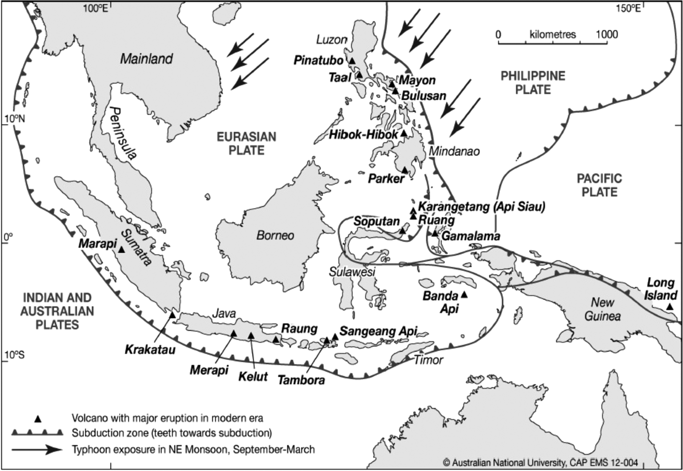

The horror of the Indian Ocean Tsunami of 26 December 2004 and a string of subsequent natural disasters have finally made us aware of Indonesia's acute tectonic dangers (Map 1). Research on the history of climate has also made such advances in the last two decades that we now understand that Indonesia's massive volcanic eruptions, such as those of Tambora (1815) and Krakatau (1883), caused havoc with climate and resultant famines around the world.Footnote 1 Historians have been slow to incorporate these new findings into their view of the past, so wide have the gulfs between our professional disciplines become. The historical work on which geological databases rest is similarly out of touch with new research in history, typically reliant on colonial-era compilations and on naively literal translations of texts.
Tectonic dangers to Indonesia.

This historian's paper seeks to close that dangerous gap by cooperating with and learning from the geologists working in Indonesia. An interdisciplinary approach is essential, but fraught in many ways by our different habits. Scientists and historians each know that their own discipline is uncertain and rapidly changing, but grasp the unfamiliar other as if it were clear-cut. A scientist would have little interest in publishing in this journal, and would look for at least a half-dozen collaborative authors to better confirm the validity of a short, technical paper. Nevertheless we must look for all possible ways to learn from each other about past events, so as to be better able to estimate future dangers.
Historical evidence for Indonesian tectonic events prior to the nineteenth century is elusive. Tsunamis were not understood as seismic events, and could only be reported as freak waves or floods. Unless European personnel and property were directly affected by earthquake or flood, these would not be reported. The tiny ‘Spice Islands’ of Maluku in eastern Indonesia were by far the best reported on in the period 1500–1800, since their monopoly on clove and nutmeg production were initially the magnet for European interest in the region, and after 1600 essential to the commercial empire of the VOC (Verenigde Oost-Indische Compagnie, the [Dutch] United East India Company). Peter Boomgaard's trawling of Dutch sources for seventeenth-century natural disasters in Indonesia found 13 volcanic eruptions and 22 earthquakes recorded for Maluku, where Dutch economic interests were at the time concentrated in monopolising clove and nutmeg. Scarcely any were recorded for Java and only a few for the pepper-collecting centres on Sumatra's west coast.Footnote 2 The Maluku record was enriched by the famous German/Dutch naturalist Rumphius, who was there in 1674 when several islands were hit by one of the most extreme tsunamis ever recorded, with a run-up claimed to have reached 100 metres, though only 2,322 of the dead could be counted. Rumphius’ account of it was printed in Batavia (Jakarta) the following year,Footnote 3 but forgotten long before plate tectonics was understood.
Indigenous sources have not survived well from this early period, with most library holdings dating only from the nineteenth century. As noted by William Marsden, Sumatrans had learned to counter earthquakes by building exclusively in wood, bamboo and thatch, making quakes ‘but little formidable to the natives’.Footnote 4 Their chronicles reveal surprisingly little of earthquakes and floods.Footnote 5 Javanese sources are more abundant, but even more demanding of scholarly skills. Given the importance of adding to our slender knowledge of Indonesia's geological past, all such sources demand much more (re-)examination in the light of the periodic catastrophes being revealed by science. Myths about origins and threats from volcanoes and seas must also be carefully re-evaluated, especially for the non-literate peoples most exposed to periodic onslaughts of mega-tsunamis in the island chain off the west coast of Sumatra and northwards to the Nicobars and Andamans.
This paper reviews the rapid advance in the scientific understanding of the seismic earthquakes which have generated tsunamis in Sumatra, and the much slower progress for Java. It presents historical evidence for two hitherto unknown great floods of the seventeenth century, possibly triggered by tectonic quakes, on the south coast of central Java in 1618 and the northwest coast of Aceh, Sumatra, in 1660. It then begins the task of weighing the effects of such disruptions on what we thought we knew of Indonesian history. I consider the evidence for a tsunami stronger in the Java case, and its import much greater, but will begin with Sumatra where much more geophysical work has been done.
Sumatra
The world's deadliest known tsunami unexpectedly struck northwest Sumatra on 26 December 2004, after a magnitude 9.2 earthquake on the subduction centred off the west coasts of Aceh and the Nicobar islands. It caused 168,000 deaths in Sumatra and another 60,000 around the Indian Ocean, while displacing millions. Scientific research on the previous pattern of earthquakes and tsunamis in Sumatra had been in its infancy before 2004, but made great strides in the ensuing decade. An important 1987 paper by Newcomb and McCann had already shown the dangers of Sumatra's subduction zones. Written by geophysicists rather than historians, it had put together existing historical evidence about their consequences to estimate magnitudes for two known nineteenth-century earthquakes, both greater than any that were recorded by seismographs in the twentieth century. They proposed magnitude 8.75 for a tectonic earthquake of 1833 that caused a tsunami affecting 550 km of the south–central Sumatran coast, the Mentawai Islands and the Dutch centre of Padang. Further north, they suggested magnitude 8.3 to 8.5 for an interplate earthquake of 1861 that caused tsunamis along 500 km of the coastline of Aceh, as well as Nias.Footnote 6
An earlier major earthquake destroyed most of the brick buildings in Padang in February 1797, and the resulting tsunami carried a sizeable ship more than a kilometre inland, destroying three buildings on the way. The Dutch reported a death toll of 300, but would have had little motivation or capacity to count victims beyond the city centre.Footnote 7 Because reportage was fragmentary at that early and unstable period, Newcomb and McCann did not find enough evidence to rate it numerically, but Caltech geologists later did so on the basis of coral upthrust (see below) to propose earthquakes with a magnitude of 8.6 to 8.8 in 1797 and 8.8 to 8.9 in 1833.Footnote 8
Little has been done to document major tectonic events prior to 1797 from the fragmentary historical evidence on Sumatra. Dutch records report that their post at Padang was heavily damaged by earthquakes in March 1691, February 1697, November 1756 (swallowing ‘whole villages’ in the interior), and 1770 (with a tsunami).Footnote 9 British reports from their post at Bengkulu, further south, confirm the importance of the 1770 event at Manna, creating a coastal plain 7 miles long and dropping the hill on which the British resident's house stood by 15 feet. They also add a tsunami in 1714.Footnote 10 For Aceh and Nias, the sites most devastatingly affected by the 2004–5 earthquakes and tsunamis, we have not hitherto been able to go back beyond 1800.
On the science front, a remarkable series of datable earthquakes has emerged from radiometric dating (U-Th disequilibrium) of the death of coral in the major uplifts that accompany tectonic ruptures. Analysis at more than twenty sites in the southern Mentawai chain of south–central Sumatra showed an uplift of more than a metre that matches the known earthquake of 1833. There were also major uplifts, differing somewhat at each site, marking significant tectonic earthquakes in about 1350, 1380, 1597, 1613, 1631, 1658 and 1703, as well as the historically known quakes of 1797 and 1833.Footnote 11 Although the relation between these measured earthquakes and tsunamis in any particular place is complex, Kerry Sieh's team of geologists at the Earth Observatory Singapore (EOS) concluded that major megathrust events have occurred at least every two centuries in that south–central area, so that another such disaster that would destroy the Padang coastal area ‘is not likely to be delayed much beyond the next few decades’.Footnote 12 Knowledge of the sea's repeated attacks on these outer defences of Sumatra helps explain why the islands remained isolated from developments elsewhere, each retaining an ancient pre-Islamic culture. Coastal settlements of traders must have formed repeatedly, but repeatedly also been eliminated by the recurrence of tsunamis.
The EOS geologists also worked on coral uplift in Simeulue, the northernmost of Sumatra's chain of offshore islands. Their findings showed quite different patterns of coral uplift in north and south Simeulue. In the northern Simeulue sites dramatic uplifts were shown in 1394 and 1450, with an error factor of only three years, of similar scale to the disastrous earthquake and tsunami hitting Banda Aceh in December 2004. The only earlier one suggested was around 956 CE.Footnote 13 Equally spectacular uplifts occurred in southern Simeulue in 1422, 1861 and 2005 (the last two matching historically known tsunamis in Nias and southwestern Aceh), but not on the same dates as the north.Footnote 14 Meltzner concludes that Simeulue somehow poses a barrier that prevented the rupture of 2004 (extending all the way north to the Andaman Islands) from continuing to the south of Simeulue, or those in the central Sumatra subduction zone — such as the historically known ones of 1861 and 2005 — from continuing to its north.Footnote 15
The region of Aceh's capital, most important for my present purpose, appears to be part of a different cycle, with less frequent interplate earthquakes and tsunamis than those of central and southern Sumatra. We have hitherto had no historical records of tsunamis there before the Dutch invasion of 1873. In the years following the 2004 tsunami some of the coastal locations it had affected were at last investigated on the ground for evidence of previous earthquakes and tsunamis. Layers of past sand deposits were identified through trench-digging in stable beach swales in western Aceh and southwest Thailand. Carbon-dating of organic material above and below each of the substantial sand layers provided approximate dates for tsunamis on the scale of 2004 in the ninth or tenth century, and again in the fourteenth.Footnote 16 A more recent excavation by an EOS team of a cave at Lhok Cut, 200 metres from the present coastline west of Banda Aceh, revealed 12 tsunami layers between 7,400 and 2,000 Before Present (BP). The average interval between major tsunamis was thus 450 years.Footnote 17 The significantly longer interval than for the coral uplift-defined earthquakes in central Sumatra may simply show that not every big megathrust earthquake necessarily generates a tsunami in mainland Sumatra, or it may suggest a different rhythm in the northern Aceh–Andaman sector.
I have suggested elsewhere the historical importance of the now known disasters of the 1390–1450 period in explaining the remarkable discontinuity of memory and historical/archaeological evidence between the pre-1350 Buddhist Lamri and post-1450 Muslim Aceh.Footnote 18 The northern Simeulue sites are unfortunately not at all revealing, however, about earthquakes that might have affected the Banda Aceh area between the events of 1450 and 1907. ‘Despite extensively searching much of the coast of northern Simeulue,’ Aron Meltzner reported, ‘we were unable to locate a single microatoll that had been alive between AD 1450 and the early 20th century anywhere.’Footnote 19 The reef flats of northern Simeulue were above sea level and the coral already dead for the whole five-century period. Evidence in the two successful excavations of beach swales at Phra Tong (southwest Thailand) and just north of Meulaboh (west Aceh) is also ambivalent at best about dating any tsunami firmly within this time period, even including the 1907 event well known from its Simeulue tsunami.Footnote 20
Further historical evidence on this ‘missing’ period is therefore precious. Fortunately the reports of a sustained Dutch presence in Banda Aceh in the period 1636–1661 have now been made more accessible through the labours of Takeshi Ito.Footnote 21 These reveal one extremely destructive flood from the sea at the end of the period, which may indeed have been an additional cause of the abandonment of the port by the VOC. A January 1660 report to Batavia from the VOC representative in Aceh read:
Unusually harsh weather … has tragically struck us here, completely beyond the expectation of anyone, between the fifth and sixth of this month [January 1660], with the fierce northeast wind and extraordinarily heavy rain. In less than 3 hours beginning at 9 in the evening the water carried over the whole land, even streaming over the walls of the forts along the beach as well as over the lofts or dwellings of most of the inhabitants, of whose houses more than a hundred were carried away by its force, and more than a thousand souls were drowned as well as innumerable cattle.
….the inhabitants here say that at no time in the memory of men has there been such a fierce flood as this.Footnote 22
The Pidië coast (around modern Sigli) was also badly affected, with 14 vessels wrecked and many men drowned there.
Whether this was a massive storm surge or a tsunami is the critical question for the geologists. It cannot be answered without further data, though the known record suggests tsunamis have been the bigger destroyers in the past. In terms of the history of Aceh, on the other hand, the cause of this disaster is less important than its results.
The Dutch report characteristically paid more attention to the loss of VOC textile stocks, as well as the damage to its rivals in the market, than to the effect on Acehnese and their state structure. Aceh was then governed by the first of its four seventeenth-century queens, Taj al-Alam Safiatuddin Shah (r.1641–75). She was a successful ruler with a much more consensual style than that of her father, the ruthless Sultan Iskandar Muda (r.1607–36), or her hard-line Muslim husband, Iskandar Thani (1637–41). She presided over a sternly independent and still-prosperous Aceh, despite grave pressure from the Dutch, who were intent on monopolising the tin of erstwhile Aceh dependencies on the (Malayan) Peninsula and the pepper exported through Tiku and Priaman on Sumatra's west coast. She had negotiated a short-lived peace with the Dutch in 1659, ending a long period of blockade of her port by the VOC.Footnote 23 She was lucky to survive the sudden flood, since she had taken many close courtiers to a ‘pleasure palace’ near the mouth of the river, and evidently had no warning of trouble as might have been expected for a storm surge. She and a few retainers were rescued by a small vessel, but many of her servants and slaves were swept away and never seen again.Footnote 24
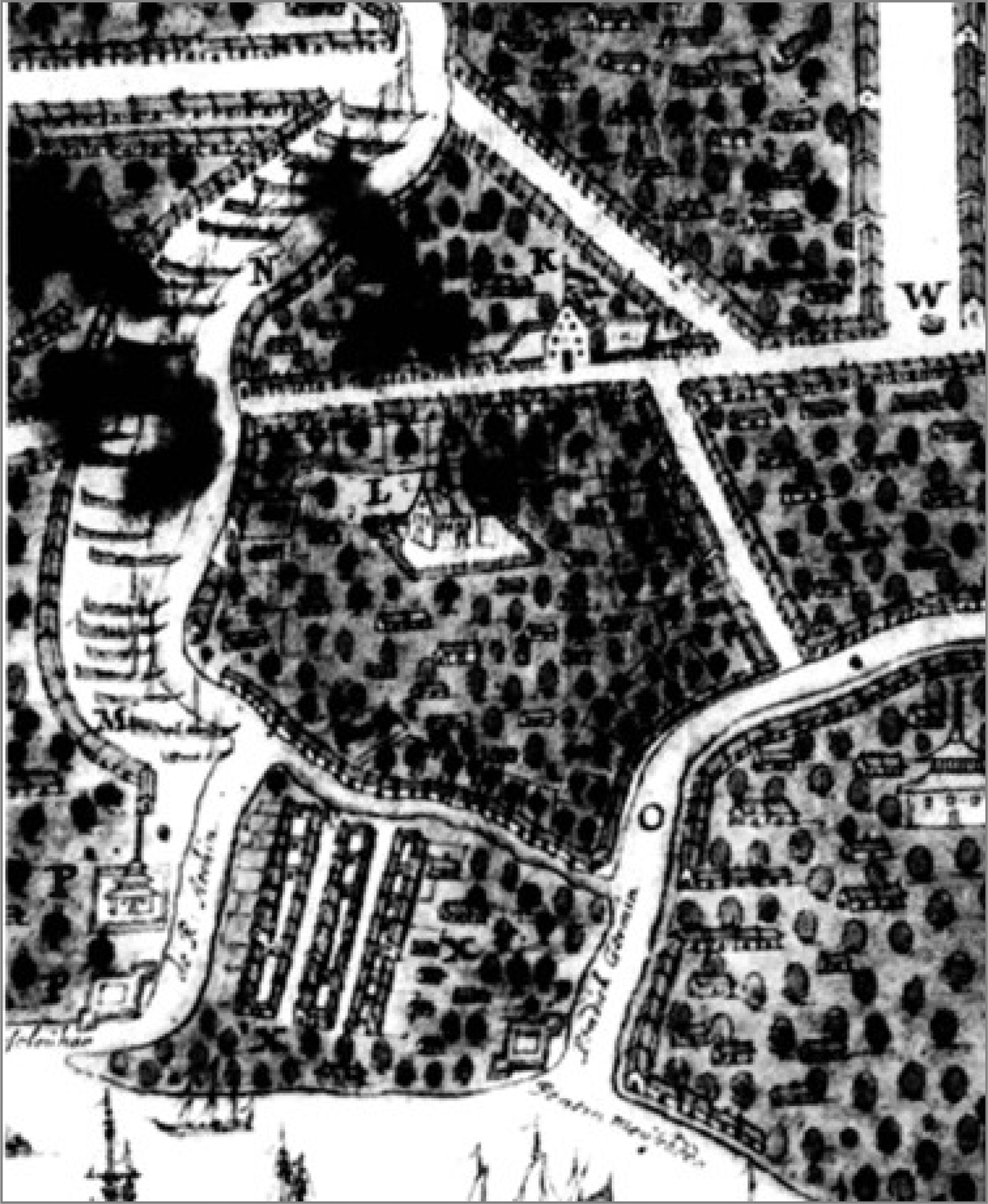
The coastal forts inundated in 1660 had been depicted on several maps (see figure 1), and carefully described by Admiral Beaulieu in the 1620s:
At the entrance to the river, which is very dangerous, there is a stone fort composed of large round bastion, which directly commands the entrance, with several gunboats which fire just above the water and flank two curtain walls also opened for several gunboats, with doors to close them off.... Its walls, both those at the place of the bastion and of the curtain walls, are 18 feet thick and about 20 high, very well made.Footnote 25
In addition there were a number of earthen forts along the coast to the northeast of the river, each about a rifle shot from the next.
Detail of Banda Aceh, showing forts at mouth of river, c. 1645. The key of this Dutch map explains: K = Dutch (VOC) lodge; L = English lodge; N = the great river [cut at Iskandar Muda's command in 1640]; O = the old river; P = the fort and mosques at the roads (anchorage) [‘t Fort ende Tempels op de Stradt]. W = well, at beginning of great avenue.Footnote 26
In 1661 the queen purchased about 60 pieces of artillery from the English, probably to replace those lost in the flood at a time of continuing tension with the Dutch.Footnote 27 The coastal forts, however, were never rebuilt. None are mentioned by Thomas Bowrey, who was there in the 1670s, or by William Dampier in 1688.Footnote 28 A 1689 Dutch report on the city's fortifications made a point of saying that:
The city of Aceh lies very open. Because it lies on the river there it is entirely exposed … There are also no fortifications, until about halfway up the river on the left side a kind of pagar [wall] has been raised, but not extended with palisades or planks but rather a simple earthen mound.Footnote 29
The tsunami or storm surge must also have destroyed much of Aceh's once-powerful fleet of armed galleys, shown as distributed close to the shore in earlier maps. Aceh effectively lost its ability to project naval power into the Malacca Strait or down the west coast of Sumatra.
Data on Aceh in the 1660s and 1670s are in short supply, suggesting that its trade was significantly disrupted by the disaster. The VOC post never regained its importance and was definitively closed in 1663. The loss of West Sumatran pepper and Perak tin are usually blamed for the decline of Banda Aceh's trade in this period, and both are indeed major longer-term factors. The 1660 event, however, suggests that Aceh's decline may have taken the form of a sudden loss of vital infrastructure and capital, from which the recovery in the 1660s and 1670s was only partial because of those longer-term factors. Traders again became frequent in the 1680s, notably after the VOC conquest of Banten (West Java) in 1684 removed the only other major independent port of the Archipelago, which had surpassed Aceh in the previous two decades. Aceh's partial revival no longer rested on an entrepot role supplying pepper, spices and tin to the world market, but rather on the export of its elephants (a diminishing resource) to India and of its gold to the world.Footnote 30 Banda Aceh remained a significant port until the late nineteenth century chiefly because it was free of Dutch monopoly control, but it never again reached the centrality, population, or wealth of the decades before 1660.
Java
Geological neglect of Java must end
The 1987 paper pointing to the danger of the Sumatra subduction zone judged that by contrast Java appeared to be less seismic, with few tectonic earthquake or tsunami events then on record. This view was founded on the absence of reports from a coast which maritime commerce had shunned. There was no Dutch post on the south coast of Java until 1839, when a controleur was placed at Cilacap to give better access to the Banyumas area. Newcomb and McCann assembled the available data for the period 1840–1985. They proposed that the largest instrumentally recorded earthquake, centred south of West Java in 1903 and felt only locally and variously classified 7.9 or 8.1, was not an interplate rupture, and produced no tsunami. Earthquakes with only moderate shaking occurred south of the Mataram (Central Java) coast in 1840, 1859 and 1921, and did produce observable tsunamis there, though more substantial earthquakes in 1867 and 1875 apparently did not. They classified most such events in the Java area as intraplate rather than the major interplate ruptures likely to cause tsunamis.Footnote 31 The largest definitely seismic, interplate rupture they analysed appeared to be only magnitude 7.2, a distinct contrast with the biggest in Sumatra's subduction zone. They concluded that the majority of adjustments on the Java section of the subducting plate were being made aseismically, and by minor shocks within the plates, and that Java-Bali-Lombok should therefore ‘be considered to have low seismic potential’. The explanation they proposed was the then prevalent theory that older subducting plates were less prone to serious seismic adjustments.Footnote 32 Java's subducting plate is estimated as being about 120 million years old, like that of Tohoku, whereas Sumatra's has been recently estimated as 35–70 million years.Footnote 33
The 1987 paper was influential enough among geologists to discourage the kind of geological research on the ground that has transformed our knowledge of Sumatra since 2004. Yet the Tohoku earthquake and tsunami in March 2011 has now demolished the hypothesis that older subducting plates such as Java's are less prone to major seismic ruptures. Robert McCaffrey had already argued that ‘Present evidence cannot rule out that any subduction zone may produce a magnitude 9 or larger earthquake’, and that Java might have done so at intervals somewhere between 700 and 3,000 years,Footnote 34 but this did little to increase the sense of urgency for research on the ground. The subduction zones that descend beneath Java and the Lesser Sunda Islands to its east have not been seriously examined by geologists for their earthquake histories since the plate tectonic theory became orthodoxy. The scientific neglect of Indonesia's earthquake geology (now excepting Sumatra) is unpardonable, though there are the usual explanatory factors — poverty, political disruption, nationalist sensitivities, Indonesia's generally undeveloped research sector, as well as the contemporary dangers and difficulties of opening problematic research frontiers in a ‘publish or perish’ environment.
Newcomb and McCann acknowledged reports of tsunamis on the central part of Java's south coast in 1840, 1859 and 1921,Footnote 35 but the lack of clear data on damage or casualties diminished the impact of these fragmentary findings. The better documentation of the last 30 years has shown that destructive tsunamis do commonly occur on Java's south coast even from relatively moderate interplate quakes. A tsunami in the eastern section of this coast on 3 June 1994 reached a run-up of 9 metres and penetrated up to 400 metres inland. It killed 223 people in three coastal villages, with about 400 injured and over 1,000 houses destroyed. This followed a magnitude 7.8 earthquake sourced by a slip close to the subduction trench, which was not felt strongly enough on land to wake more than 20 per cent of the threatened coastal inhabitants.Footnote 36 In July 2006 another tsunami affected some settlements on the south coast of West Java, notably Pangandaran, where about 700 people were killed by a tsunami arising from a magnitude 7.7 earthquake. Both these events are now understood as ‘tsunami earthquakes’ caused by slow rupture of the megathrust, with outsized tsunamis because of their shallow location.Footnote 37
Given the very high population density, and indifferent construction controls and warning systems in Java, even a relatively modest tsunami could cause massive suffering. Although the hypothesis that the Java subduction zone is aseismic is no longer tenable, there remains a danger that systematic research into past patterns will not begin until there is another horrendous disaster for which the population will have been poorly prepared.
Reportage before 1800 was largely restricted to Dutch settlements on the north coast of Java — not exposed to tsunami events. The most detailed information came after 1619 from the VOC headquarters at Batavia (modern Jakarta). This reportage confirms that Batavia/Jakarta suffered much more from earthquakes in the seventeenth century than the twentieth, though we cannot know whether these derived from interplate ruptures of the megathrust under Java's little-populated south coast. In 1648 Dutch construction efforts were held up by a series of earthquakes.Footnote 38 In December 1653 there was ‘a heavy earthquake, lasting for many consecutive days [in Batavia], from which many buildings and houses were cracked, damaged and collapsed, and thereby quite a number of people were killed, Chinese and natives’.Footnote 39 On 5 January 1699 Batavia experienced ‘an earthquake so heavy and strong that nothing comparable had ever been known to have occurred here, the movement having lasted with severe shakes and shocks for about three-quarters of an hour. The damage to the Dutch centre of the town included 28 killed and 49 stone buildings collapsed, though later reports indicated 40–50 deaths.Footnote 40 The epicentre appeared to be in the mountains southwest of Batavia, where hills were split and thousands of trees uprooted, many carried to where they blocked the town's rivers. Buildings were also wrecked in the major port of Banten, west of Batavia on the north coast. As far away as the chief coastal town of Lampung, in South Sumatra, over 100 were killed.Footnote 41
A persuasive tsunami myth – Ratu Kidul
The Dutch sources have the great advantage of being written as reports at the time of the events, and well preserved in archives. Their absence for the south coast of Java before 1840 means that we must turn again more carefully to Javanese sources, even though extant documents were written well after the events they describe — generally in the nineteenth century. In marked contrast to Japanese historical sources which have revealed much about earthquakes and tsunamis, those of Java are mostly very poorly dated and opaque to the modern reader. Chronicles of long-past events were compiled to legitimate dynasties and explain disasters mythologically, rather than to document events. Scholars have consulted them as often sublime literature and sources of religious meaning. The diminishing handful of historical scholars equipped to use them have been chiefly concerned to establish royal chronology and a meaningful narrative of court-centred events. The chronicles do often mention volcanic eruptions as cosmic omens, but they have not appeared to be very rewarding for earthquakes and floods from the ocean.
Here, as elsewhere in Indonesia, mythology so dominates explanations of the past that it must be examined seriously for clues to past traumas. As it happens, the Mataram dynasty's chronicles of the seventeenth and eighteenth centuries (of which extant versions date from the eighteenth and nineteenth centuries) contain a central explanatory myth which is as explicit a warning of tsunami danger as any such tradition I am aware of. The primary key to power in Java was seen in the court chronicles, oral traditions and royal rituals to be Ratu Kidul or Nyai Loro Kidul (the ‘Queen of the South Seas’), who had her palace in the southern ocean off the central Java coast. The origins of the idea of this magically powerful and dangerous lady may be ancient, and perhaps indeed connected with widespread myths linking the feminine with the sea. If it is the case that Java was hit by massive tsunamis every few centuries, then one would expect that the southern ocean would have a mythic place alongside volcanoes as part of the most ancient Javanese nature religions. The scholarship before tectonic plate theory tended to see Ratu Kidul as ‘an ancient Javanese chthonic Mother-goddess’, identified in the era of Indianisation with the Saivite high goddess Durga or the Majapahit royal ancestress Rajapatni.Footnote 42
Only in the seventeenth century does this lady assume her present name and form, however, as the primary legitimation of the Mataram dynasty, which for the first and last time united the whole Javanese-speaking area during the conquering reign of Sultan Agung (1613–46). The chronicles and traditions of that dynasty, continued after 1755 in the rival courts of Yogyakarta and Surakarta, identify her as a beautiful virgin queen/princess from the spiritually powerful mountains of West Java. She was empowered, or alternatively cursed, by the gods to live as a virgin in the southern ocean and rule over Java's spirit world, until a Javanese king worthy of her made her his wife. The nineteenth-century Serat Babad Nitik tells the mythic story of Sultan Agung by explaining that after her long sojourn in the southern ocean, the gods declared that it was time for her to marry. The future Sultan Agung meditated so powerfully at a sacred mountain that
The Merapi volcano began to tremble and spit out tongues of fire, the ocean moved as though boiling … The Queen herself came to face Sultan Agung. Their meeting and subsequent union was like that of the goddess Sri and the god Wisnu.Footnote 43
Ratu Kidul was the most important legitimating figure in the literature and ritual of the courts of Mataram and its successors, which have actually or ritually ruled Java for the last four centuries. The sacred axis of court life was held to run from the volcano Merapi in the north through various sacred points, including the palace, to the sea at Parangtrites. Volcano and sea were the twin poles, north and south, around which the cosmology of the Mataram kingdom and its successors revolved. Whereas the spectacular power of the volcano was demonstrated to virtually every generation, the ocean has not done so in human memory. Yet Ratu Kidul is the more ritually powerful figure. She features centrally in the Great Chronicle or Babad Tanah Jawi, first written down in the late eighteenth century. All Mataram kings are said to derive their power and legitimacy from their ritual mating with her, widely believed to transport the kings magically to her undersea palace. The tradition has been kept alive in the separate courts of Yogyakarta and Surakarta by the annual ritual offering of the rulers’ hair and nail clippings to Ratu Kidul in the sea at Parangkusumo, at the mouth of the Opak River adjacent to Parangtrites,Footnote 44 and by a slow, stately dance performed by nine female dancers in the presence of the king. This dance was said to have originated when Sultan Agung visited Ratu Kidul's underwater palace and was entertained by the Queen with the dance, though the earliest firm evidence of it comes from a Dutch description in 1726.Footnote 45 Its annual repetition is said to ritually enable the kings to again visit her and revalidate their power. After the separation of the two courts on Dutch auspices in 1755, Surakarta staged the Bedoyo Ketawang and Yogyakarta the other dance of Ratu Kidul, Bedoyo Semang. The litany sung with both evokes the union of the kings with Ratu Kidul in romantic, often erotic terms designed also to magnify the supernatural power of the king.Footnote 46
Although most Javanese kings after 1600 reportedly enjoyed spiritual and erotic relations with Ratu Kidul, ‘it is upon the one with [Sultan] Agung that Javanese traditions tend to dwell’.Footnote 47 He was a documented historical figure well known to the Dutch, and his conquests made him the paragon of Javanese kingship. The Babad Tanah Jawi begins the story, however, with Agung's presumed grandfather, Senopati, about whom little definite is known, but who was especially in need of legitimation as the founder of the upstart Mataram dynasty. As related in the often reprinted ‘Great Babad’, semi-canonical since being written down in Surakarta in 1836, Senopati prayed at the mouth of the Opak River, facing the southern ocean, with such supernatural power that:
a great tempest came from the West, with wind and rain. Many trees were snapped off or uprooted. The waves of the sea were as big as mountains. The sound was terrifying. The water of the sea was boiling hot. Many fish were thrown onto the rocks and lay dying on the land.Footnote 48
Ratu Kidul was alarmed by this unprecedented disturbance to her realm, and wondered whether the sun had fallen to the sea or it was the end of the world. Another, unpublished, chronicle renders her words as ‘What is this really? So long as I have existed, I have never seen the ocean like that, its uproar gigantic, the water as if it were hot.’Footnote 49
When she realised that it was Senopati's supernatural power that had caused this cosmic disturbance, she promised that his prayers would be fulfilled. He and his progeny would rule a great kingdom, and command all the spirits under Ratu Kidul's control. The same text returns to the subject of Ratu Kidul in discussing the supernatural power of the great Sultan Agung, who went frequently to her palace beneath the ocean, took her to wife, and through her commanded the spiritual forces of Java.Footnote 50
The many stories and continuing rituals about this powerful queen and her relations with the kings of Java became common knowledge among Javanese.Footnote 51 As documented by anthropologist Judith Schlehe they are still of enormous importance today.Footnote 52 They enhanced the popular fear of the southern ocean down to modern times, playing a useful part in discouraging settlement on the dangerous south coast long after any memory of a tsunami was lost. The centrality of the myth for the Mataram dynasty suggests that the last such spectacular tsunami on that coast occurred about 400 years ago, at around the time the Mataram dynasty arose in the reigns of Senopati and Sultan Agung. Can Javanese sources tell us more about a specific event?
Can we date a Mataram tsunami?
If any year is connected by these sources to the mythic memory we have described, it is the Saka (Indic) year 1540, equivalent to the year beginning 1 March 1618 in the Common Era (CE). When the Surakarta court was asked by a Dutch official in 1932 to explain and document its annual ritual offerings to Ratu Kidul at Parangtrites, the date for its origin in Senopati's union with the Queen was reported to be Saka 1540.Footnote 53 Most extant versions of the babad tradition, written down in the late eighteenth or nineteenth centuries, give either Saka 1535 (1613 CE) or Saka 1540 (1618 CE) as the date of Senopati's accession, his meeting with Ratu Kidul, and the beginning of the dynasty.Footnote 54
These dates are surprising, since it is known that Sultan Agung, not Senopati, came to the throne in S1535 (1613 CE). The reign of Krapyak intervenes in the chronicles between those of Senopati and Agung. Although the most widespread date in the chronicles for Senopati's death is the ‘wildly erroneous’ Saka 1553 (1631–32 CE),Footnote 55 the historian who tried to produce a coherent narrative from the confusing sources, H.J. de Graaf, argued that he must really have died in 1601 CE.Footnote 56 Although Merle Ricklefs showed his calculations to be mistaken,Footnote 57 this 1601 hypothesis has entered textbooks and become canonical.
Why did the majority of chronicles confuse Senopati's reign dates with Agung's, by claiming the reign began in Saka 1535 or 1540? Saka 1535 can be explained as a conflation of Senopati with the better-known Sultan Agung, who did indeed come to the throne in that year, and who was equally believed to have a unique union with Ratu Kidul at the beginning of his reign.Footnote 58Saka 1540, however, is very difficult to explain unless something significant did happen in that year. Since the date is strongly connected to the emergence of Ratu Kidul as guarantor of the kingdom, the evidence of the chronicle tradition appears to suggest that Saka 1540 (1618–19 CE) was significant precisely because a major event connected with the southern ocean occurred in that year. This single event would later be mythologised to legitimate both the dynasty's problematic origin in an upstart warrior (Senopati) and the mighty ruler actually associated with the date and with Mataram's apogee (Agung).
Fortunately there is a more chronologically reliable source than the Babad Tanah Jawi, and one put onto paper in 1738, considerably earlier than the better-known texts of that tradition. This Babad ing Sangkala (Dated or Chronogram Chronicle) was seized by the British in Java in 1812, and rediscovered and given a modern edition only in the 1970s. It is a dated year-by-year summary of events in poetic form, though relatively free of the mythic elements of the other tradition. Its modern editor, Ricklefs, concluded after comparing it in detail with Dutch and other external evidence that ‘it is a remarkably accurate account of events in the period ca.1601–46,’ avoiding the attempts of the Great Babad tradition to fit the facts into a mythic pattern of repeated cycles.Footnote 59 This chronicle gives us the year in which numerous important events occurred, notably including the destruction of cities by war, fire or earthquake, the death of leaders, wars, the construction of buildings, canals and dams, the arrival of envoys, and such key matters as the arrival of tobacco in Java (1600) or the introduction of copper coins (1661–62). Natural events such as earthquakes (1584), a lightning strike (1654), volcanic eruptions (1527, 1634–35, 1641–42, 1663–64, 1671–72, 1716), river floods (1652), epidemics (1625–26, 1643–44, 1663–64), comets (1652, 1663–64) and eclipses (1538–39, 1601–02) are noted by year. It says nothing of mythic imaginings such as Ratu Kidul. The dates are expressed in the form of poetic chronograms, whereby each digit of the date has a word equivalent that should match the meaning of the verse.
The only event in the chronicle that could mark a tsunami occurs in the same Saka year 1540, which ran from March 1618 to February 1619. An image of devastating flood occurs no less than three times, each expression of this disaster being in the form of a four-word chronogram equivalent to the Saka date 1540. The Ricklefs translation of each chronogram is here given in italics.Footnote 60
When disappeared, turned into sea, was the earth [nir tasik buta iku bumi] the people of Pajang were defeated;
they left their land. Their Adipati sought refuge in Giri Liman.
In Mataram, they moved [the court] to Karta, indeed, when disappearing, all was turned into sea [nir tasik buta tunggal],
Pringgabaya fell in fear, when disappeared the sea and the five lands [nir sagara ponca bumi].
Professor Ricklefs was kind enough to look again at the text in light of the possibility that a tsunami was referred to here. He pointed out that the word nir (disappeared) occurs in the text only in these three occasions. Although unconvinced that there is enough evidence in Javanese sources alone for a tsunami, he suggested that buta in the first two chronograms be read more appropriately in its normal meaning of ‘giant’, leading to a translation as follows:
I:26d-e, nir tasik buta iku bumi: disappeared, a giant sea was the land
I:26j, nir tasik buta tunggal: disappeared, a single giant sea
This evocative language does seem to make clear that the exceptional event connected with Ratu Kidul in Saka 1540 (1618–19 CE) was indeed a spectacular flood. Among other dated chronicles, Professor Ricklefs was able to find one other chronogram suggesting a flood-like event in Saka 1540. An unpublished Surakarta text of 1815 mentions that ‘The war in Tuban was in swept away by water was the garment of the world’, i.e. Saka 1540.Footnote 61 This could be held as reinforcement for the dating of a spectacular tsunami in 1618–19 CE, though since Tuban is on Java's north coast (as indeed is probably the Pringgabaya above, one candidate for which is near Surabaya) this could also suggest another possible explanation — that it was the Solo river which flooded unprecedentedly, perhaps exacerbated by lahar movements after a volcanic eruption. A tsunami explanation appears more probable, however, because no other river flooding events are explained in this way, because the Dutch and other foreigners are more likely to have noticed a spectacular flood if it occurred on the north coast, but above all because of the strong association of Saka 1540 with Ratu Kidul.
What effects would a tsunami in 1618 have on reading Java's history?
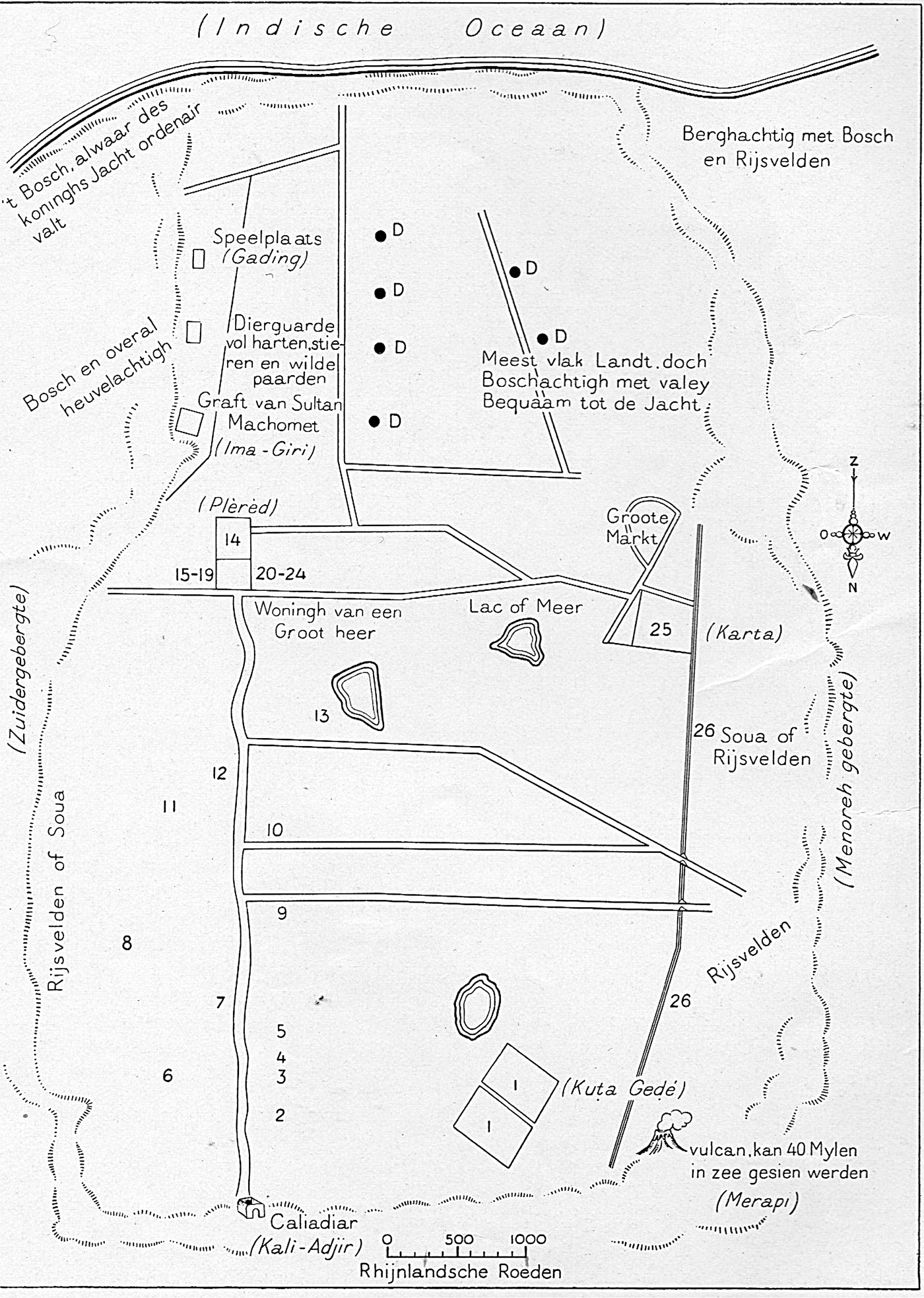
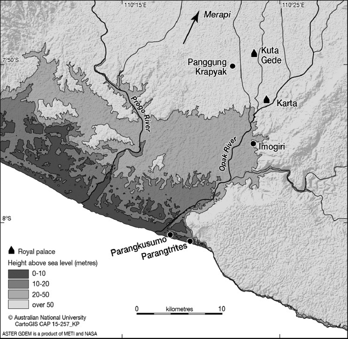
Firstly, one should make clear that a tsunami could not have had catastrophic effects directly on the Court of Sultan Agung of Mataram. This was at today's Kuta Gede, in the southern corner of the present city of Yogyakarta, over 20 km from the southeastern ocean. A mega-tsunami on the scale of the 2004 Sumatran one might have generated a wave height of 50 metres, or a smaller one, like that of Pangandaran (West Java) in 2006, only 20 metres. As made clear by Map 2, even the larger one should have exhausted itself well before reaching the royal kernel of the kingdom in what are today the southern suburbs of Yogyakarta. It would have caused total destruction of all coastal establishments, and have penetrated perhaps 10 km inland, notably up the valleys of the Progo and Opak rivers. If the coastal plain was covered in rice cultivation, as it is today, it would have destroyed that production and discouraged cultivation for the next half-century, leaving the area south of the capital as a wilderness suitable for hunting — as it was reported to be in the 1650s (see figure 2).Footnote 62 Agung does appear to have moved his court southward from Kuta Gede to Karta in 1618 CE, as reported by the Babad ing Sengkala above, but not because Kuta Gede had been destroyed. Rather, this spectacular event may have been seen as a supernatural demonstration that a new beginning was required, to an era where Mataram was allied with the cosmic forces of the southern ocean. Both Sultan Agung's new capital at Karta, and his destined burial place at Imogiri, could be read as signalling that alliance.
Rijklof van Goens’ sketch of the Mataram capital around 1650, with the south coast at the top, as schematized by H.J. de Graaf, in De Vijf Gezantschapsreizen van Rijklof van Goens, 1956. The area between the royal capitals and the sea is described as ‘Mostly flat land, but wooded with valleys. Suitable for hunting’, and de Graaf has indicated with D (dieren = animals) van Goens’ tiny pictures of deer.
Low-lying areas that could have been inundated by a Mataram mega-tsunami. Karta and Imogiri were built by Sultan Agung, Kuta Gede and Krapyak by his immediate predecessors.
Agung's material losses from a tsunami would have included many of his subjects and probably significant rice fields, but perhaps above all a port on the south coast. The later, larger Mataram conducted all its commerce by difficult roads and rivers to the ports on the north coast, but it is very possible that either the Opak or Progo river-mouth before this coast-changing event offered a significant port for a rising kingdom — just as it may have for the first Mataram civilisation in the seventh century. One consequence of a dramatic tsunami event may therefore have been to close the south coast as a communications option, and intensify Mataram's quest for domination of the north coast and its ports. De Graaf's ingenious construction of Java's history has the conquests beginning earlier, under Senopati in the 1580s, but this remains speculation, as do all the reconstructions of events at that murky period. There is better evidence for Sultan Agung's influence over Japara and Lasem from 1616. But Mataram's definitive politics of expansion began only with the conquest of Pajang (near Surakarta) in 1618, and the bitter struggle to subdue the coastal ports thereafter. The myth of Ratu Kidul as an explanation of cosmic crisis presaging Mataram's rise could have been gradually embellished by scribes as the event itself retreated from memory.
VOC reportage is the usual resource of historians needing a check on the reliability of fancifully-written Javanese chronicles. But Dutch knowledge of Mataram affairs was minimal, especially before they established their permanent Asian base in Jakarta in 1619, renaming it Batavia. Until they began to interfere in Javanese affairs later in the century, Dutch interest in the interior was mainly in getting a supply of rice for their ships and troops from the Javanese heartland, usually through the central north coast port of Japara. This rice stopped coming early in 1618, and so Governor-General Reael despatched an envoy to try to reach the King of Mataram and ask for favourable access to rice supplies. The envoy, Cornelis van Maseyck, reached as far as the Surakarta area at the end of June 1618. There he learned that the older capital of Pajang, near Surakarta, had been conquered by Sultan Agung, and the population of all the surrounding villages had been taken away to build the new Mataram. The envoys could barely find enough food for their own survival. Van Maseyck was told that it was strictly prohibited to export rice, because even in the capital itself rice was extremely expensive.Footnote 63 Another Dutch report claimed that rice was said to be so expensive in Mataram that ‘a great many people’ were dying of hunger in its capital. H.J. de Graaf concluded from this that it must have been Sultan Agung's war with Pajang that caused the rice shortage, and so Pajang must have fallen earlier than the chronicle said, in 1617 rather than 1618.Footnote 64 Natural disasters, however, may have played a larger role.
Despite de Graaf 's efforts to construct a coherent political history by combining Dutch sources with the summarised babads, almost everything remains in doubt about Mataram before Sultan Agung. The dated inscriptions which help us in the Majapahit period were no longer available in the sixteenth century. Dutch documents become a useful check on Javanese story-telling only in Agung's reign. Prominent Javanist C.C. Berg argued that most of the stories about Senopati had been created by the eighteenth-century chroniclers to give supernatural legitimacy to the upstart Mataram dynasty and enhance Sultan Agung's glorious destiny.Footnote 65 He held that the Senopati stories, including his accession date, Ratu Kidul marriage, conquests and death, were so similar to those of Sultan Agung that the chroniclers must have simply used them in fabricating the story of the dynastic founder. Ricklefs’ nuanced adjudication of this ongoing debate preferred to see confusion between Senopati and Agung on the part of chroniclers and copyists, rather than Berg's idea of deliberate myth-creation. Above all he insisted on consulting the whole diverse range of Javanese writing, not prioritising the more accessible but not authoritative Babad Tanah Jawi. Footnote 66
The establishing of a 1618 tsunami early in Agung's reign, as the key ingredient in giving such currency to subsequent Ratu Kidul mythology, would add substance to Berg's idea that Senopati stories were borrowed from the better-known and more illustrious Agung reign. Further research on this confusing period might establish whether Senopati's alleged conquests of Pajang and other polities to the north and east were any more than mythic foreshadowing of Agung's all-Java destiny. In either case Sultan Agung's determination to control the north coast ports and unite Java under his sway would owe something to this extraordinary natural event near the beginning of his reign.
*
How can these suggestive findings be tested further? More thorough re-examination of Javanese and Dutch records might help a little, but there can be no substitute for systematic geological studies of past tsunamis. The absence of offshore islands near the subduction trench off Java's south coast may make it more difficult than in Sumatra's case to find either datable sand deposit layers, or abruptly uplifted coral. Nevertheless, following the 2006 tsunami in Pangandaran, an Indonesian team found there a layer of sand thicker than that of the 2006 tsunami above a layer of mangrove mud carbon-dated very approximately to 400 years before the present.Footnote 67 This, however, was a very small step towards the long overdue systematic scientific work on a cooperative Indonesian–international basis. The Australian northwest coast, which would also be hit by any large Java tsunami, is little better researched, and its big tides and intense tropical cyclones can obscure the effects of a tsunami. One research team has cited geophysical and mythic evidence for a truly mammoth tsunami in the Kimberleys at some time in the seventeenth century, but this has not been widely accepted.Footnote 68
The job remains to be done.