BUCKINGHAMSHIRE
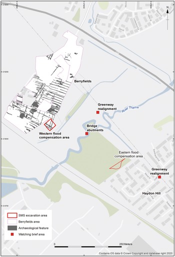
(1) Aylesbury, Waddesdon Greenway, Thame Crossing (SP 7935 1504):Footnote 58 a programme of archaeological works was undertaken as part of an extension to a pedestrian and cycle path linking the village of Waddesdon with Aylesbury. The work involved the strip, map and sample excavation of two flood compensation areas and archaeological monitoring of groundworks along the route, including the installation of bridge abutments over the River Thame. No archaeological remains were identified within the eastern flood compensation area or during watching brief in the area of the new bridge abutments. The strip, map and sample excavation of the western flood compensation area revealed Roman activity (fig. 30). The excavation also exposed a continuation of the ditch system revealed during previous excavations at the adjacent Berryfields development.Footnote 59 Together the ditches constituted part of an Early Roman field system lying south of Akeman Street, at the periphery of the small town at Fleet Marston. The limited number of other features, finds and environmental remains demonstrate agricultural use of the land during the Early Roman period. A not closely dated Roman cremation burial was also encountered during the excavation.
Plan of the Waddesdon Greenway excavation and monitoring areas in relation to the Berryfields excavation. (© Oxford Archaeology)

(2) South Caldecotte (SP 89100 34170):Footnote 60 excavations over a c. 48 ha development site uncovered settlement and funerary activity peripheral to the Roman small town of Magiovinium.
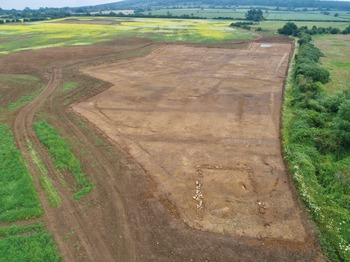
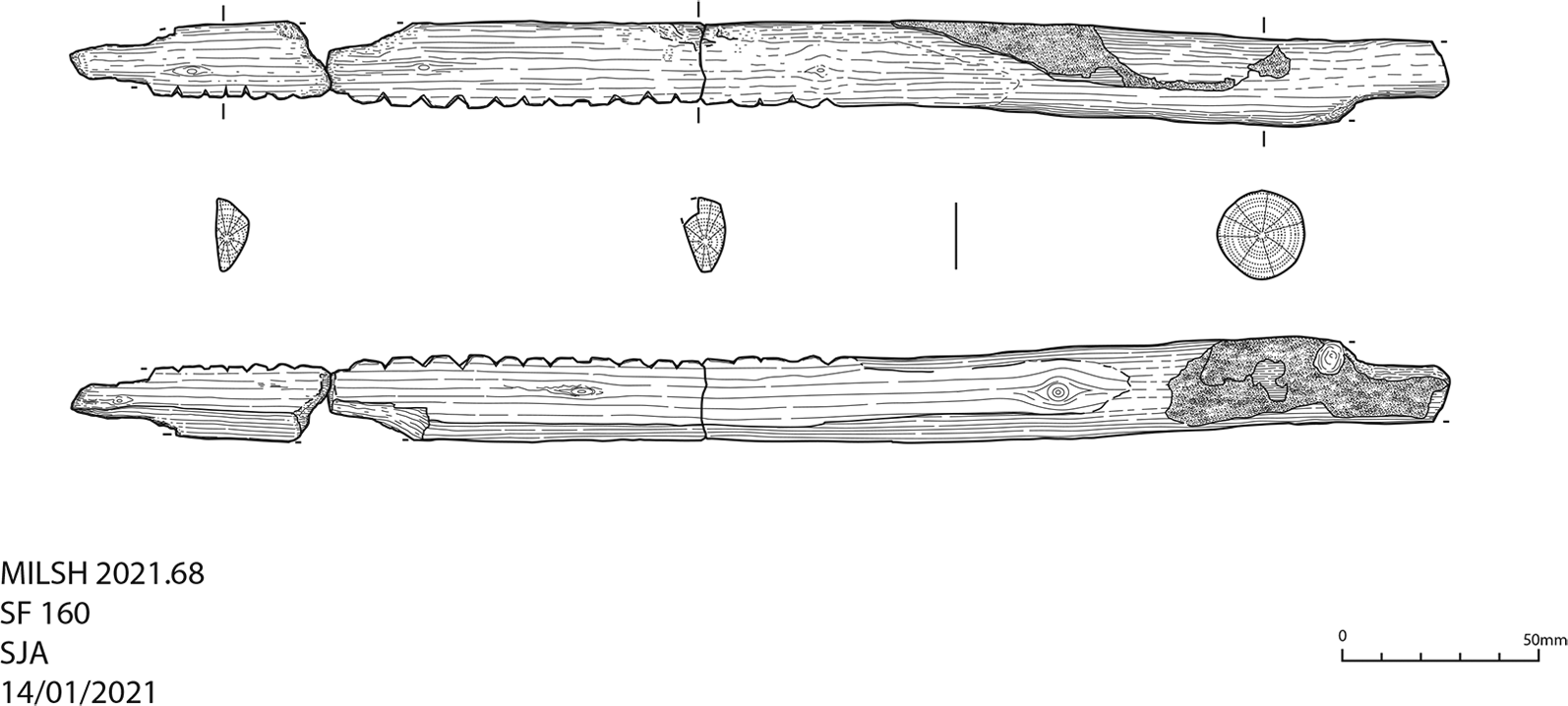
Area 1 contained first- to second-century land allotments and a small square shrine associated with a mixed inhumation and cremation cemetery. Area 2 targeted an isolated small square barrow with a central mound and cremation, also first to second century in date. Area 3 revealed a short-lived settlement dated to the late Iron Age to Early Roman transition. Areas 4 and 5 revealed c. 1.5 ha of enclosed Romano-British settlement adjacent to a spur of Watling Street, heading north from Magiovinium. A road, represented within the excavation by parallel ditches, was also identified to the south by Neal.Footnote 61 The main enclosures were established east of the road; some contained evidence of habitation while others appeared to enclose funerary activity. The artefactual assemblage suggests that the enclosures were primarily occupied from the first to third centuries. A deep inhumation burial contained a large, poorly preserved iron object tentatively suggested to be the linchpin from a cart or chariot wheel. A least one large rectangular timber building was identified, as well as a small roundhouse gully. West of the road and separate from the main settlement activity, the foundations of a rectangular building were excavated which were constructed using locally sourced limestone and sandstone (fig. 31). The function of this building is unclear, but a number of cremation burials were identified in its vicinity. Of particular interest is a wooden object, recovered from a deep pit, which is thought to be a scutching knifeFootnote 62 used in the production of linen from flax (fig. 32). No Romano-British parallels have been published previously; examples are known from the continent but from no earlier than the ninth century. The amount of Roman pottery recovered from the same pit makes it unlikely to be residual and if the object is of the same date, then it is one of the earliest examples to have survived.
South Caldecotte. Aerial photograph of Area 4 from east (stone building and road in foreground).

South Caldecotte. Scutching knife. (Illustration by S. Allen.)

CAMBRIDGESHIRE
(1) Multi-parish, Sunnica West sites A and B (TL 6394 6864 and TL 6619 6672):Footnote 63 large-scale evaluation was undertaken at the proposed Sunnica West solar farm site in fields across Snailwell, Chippenham and Kennet parishes.Footnote 64 Fields were designated W01–W12, W14 and W15. Roman remains were uncovered in five fields, including Field W01 where palaeochannels and alluvial deposits in the flood plain of the River Snail contained Roman material. Peat deposits here may date from the Roman period as Roman features were excavated, including pits and trackway ditches around the periphery of a settlement identified on geophysics. In Field W03 enclosure ditches of Late Iron Age to Early Roman date were found, which represent part of a previously evaluated settlement extending to the north-east around Foxburrow Plantation. Settlement of probable Roman date was recorded in the north of Field W04 during a previous geophysical survey on former RAF Snailwell. In the same field ‘The Ditch Way’, which is a probable Roman road connecting Ashwell Street to Street Way, was traced by geophysical survey as two diverging trackways. In Field W08 Early Roman enclosure ditches, possibly associated with the northern branch of ‘The Ditch Way’, were exposed, along with a large pit or pond. In Field W10 Roman finds associated with nearby settlement were found in a large natural pond or hollow.
DERBYSHIRE
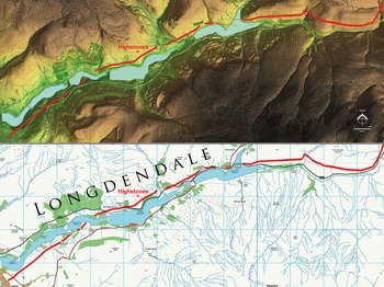
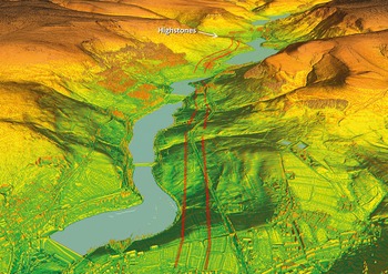
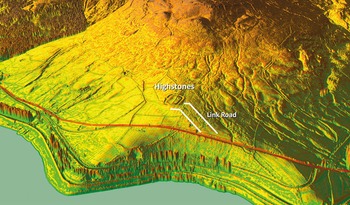
(1) Longdendale, Manchester to Doncaster Roman Road (SK 02879 96733; SK 03277 97029):Footnote 65 the alignment of the Roman road from Manchester to Melandra was located in 2020 when it was found to pass c. 1 mile to the north of Melandra fort. The road was first spotted in the lower part of the Longdendale Valley by Glossop and Longdendale Archaeological Society. Improved LiDAR technology has enabled the route to be accurately mapped, showing that it continued the full length of the valley before it traversed over Windle Edge and into the upper Don Valley (fig. 33). Despite all the reservoirs constructed along the route, the LiDAR survey revealed (fig. 34) the point where the road crosses from the south side (SK 04832 98154) of the valley to the north (SK 05164 98435). Once on the north side of the valley the Roman route passes Highstones, previously suggested as a possible Roman fortlet. LiDAR clearly shows this to be correct with a southern entrance shown (fig. 35). It is a well-chosen spot with extensive views both up and down the valley. The fortlet would have needed a connection to the main Roman road and the link road up to it is faintly visible (SK 06566 98994). Beyond Highstones, passing Crowden, the typically direct Roman agger has survived (SK 07255 99215 – SK 07620 99382 – SK 07930 99544 – SK 08129 99666). Further east then the visible evidence is more intermittent but its onward course to Salter's Bridge can be deduced with reasonable confidence. Its continuation in Yorkshire along the upper Don valley as far as Hoylandswaine is recorded in that county's section.Footnote 66
The route of the Roman road through the Longdendale valley. There are some interpolated stretches (shown dashed) but generally the course is reasonably secure. (Base LiDAR data is © Crown Copyright. Mapping is Ordnance Survey Opendata © Ordnance Survey)

Oblique LiDAR view looking east into the valley. The road crossed from the south side of the valley to the north before Highstones fortlet. The location of the fortlet afforded excellent views up and down the valley. (Base LiDAR data © Crown Copyright)

Oblique LiDAR image of the Roman road (marked in red) passing Highstones fortlet. The southern entrance is obvious but the western one is possibly a later disturbance as the rampart does not appear to have a corresponding gap in it. There is faint evidence for a link road. (Base LiDAR data © Crown Copyright)

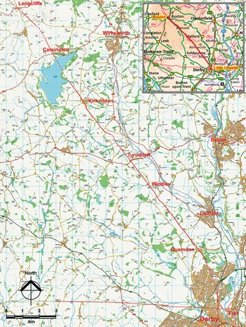
(2) Multi-parish, Little Chester to Buxton Roman Road (SK 21000 57356; SK 24100 54420; SK 26297 50674; SK 33464 41346):Footnote 67 heading southeast from Buxton over the limestone uplands is a very well-known and direct Roman road aligned on Little Chester, Derby. This road is locally known as ‘The Street’ (Margary 71a) and is situated on the limestone uplands where it has survived extremely well. It can be traced as far as Longcliffe near Brassington. Beyond Longcliffe the route was uncertain with the most recent suggestions being that it most likely went via Wirksworth and down the Derwent valley to Little Chester. LiDAR has revealed (fig. 36) that the road, rather than going via Wirksworth, followed a very direct route between Longcliffe and Quarndon, northwest of Derby.Footnote 68 There were three main alignments between four setting-out points, namely: Minninglow (SK 21000 57356, 365 m AOD), Carsington Pasture around SK 24100 54420, 331 m AOD), Winson Farm (SK 26297 50674, 251 m AOD) and Quarndon House (SK 33464 41346, 148 m AOD).
Route map for the southern section of The Street. (Base mapping is derived from Ordnance Survey Opendata © Ordnance Survey)

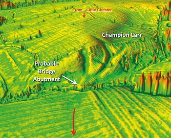
Between Minninglow and Carsington Pasture the Roman road follows the straight alignment almost exactly, although for its final course at Carsington Pasture it probably skirted around the very highest point. On the second alignment to Winson Farm then the road adapted to the contours and cleverly utilised a spur of high ground (SK 24487 53614) to ease the descent down to what is now Carsington Reservoir. A strategically located zig-zag kept the gradient to no steeper than 1 in 7.5. On the final main alignment there was just a single short parallel deviation at Rakestones Farm (SK 27513 48834) to make use of a ridge of high ground. A feature on this alignment is the large number of excavated cuttings in order to negotiate the side valleys of the Ecclesbourne valley, the most spectacular of which is a pair of twin cuttings at Champion Carr (fig. 37), where a second curving relief route had been constructed (SK 31753 43513). This reduced gradient from 1 in 6 on the direct line to 1 in 10. In addition to the many cuttings there was a 500 m long terraceway with revetment north of Windley on the side-sloping ground below Flower Lillies (SK 30270 45525). It is likely that the modern Woodlands Road represents the road's final direction to the fort at Little Chester. Proving the route of this road lends support for the location of Lutadarum, the lost Roman lead-mining site, being in the Carsington area. Its route would have passed through the recorded Roman settlement (Derbyshire HER 3379), now under Carsington Reservoir. This site was also next to Scow Brook (a water supply is essential for lead processing) and just to the south of the many old lead mines on Carsington Pasture.
The remarkable twin cuttings for the Roman road at Champion Carr, Windley. (Base LiDAR data © Crown Copyright 2020)

LEICESTERSHIRE
(1) Leicester, Jewry Wall (SK 5817 0449):Footnote 69 an archaeological excavation and watching-brief was carried out in advance of the redevelopment of the museum and grounds.Footnote 70 The works lie within the Scheduled Monument of the Jewry Wall Roman baths (National Heritage List number: 1013312). A strip, map and sample excavation was undertaken in advance of a new rear lobby. A series of Early Roman pits, which pre-date the Roman baths, contained pottery, butchered animal bone, plant remains, also a small amount of metal-working evidence. The east–west wall-line was also observed, thought to be the north wall of the north portico (most likely robbed away in the medieval period). A watching-brief was undertaken for a new access ramp to the south of the ruins during which Roman remains were observed consisting of two mortared walls: the lower courses of an east–west wall, and a north–south wall running almost perpendicular. The north–south wall had at least one tile course of four tiles depth and is the west wall of the large stone-built channel that encompasses the south and east side of the baths. The east–west wall is thought to be part of the south portico of the bath-house. Within the internal angle of these two walls were surviving opus signinum floor levels. Finds recovered during this work consisted of pottery and remains of several glass vessels of a late first- or early second-century a.d. date.
(2) Market Harborough, Overstone Park (SP 7475 8640):Footnote 71 a c. 10.5 ha excavation on the south-east outskirts of the town was undertaken in advance of residential development and revealed Early Roman settlement. The first century a.d. saw a major reorganisation of an earlier Iron Age settlement where a series of rectilinear enclosures replaced the predominantly sub-circular enclosures of the previous phases, while the settlement core shifted to the north-west. The rectilinear outer boundary and internal enclosures were similar in layout to those identified at Airfield Farm, c. 3.3 km to the north-west. The settlement covered an area of c. 0.8 ha, continuing beyond the site limits site to the west, where elements had been excavated by Northamptonshire Archaeology in 2012. The finds assemblages suggest domestic activity took place in many of the enclosures, although only one produced evidence for buildings. Other features included a small inhumation cemetery, which contained three individuals and likely represents a family plot, as well as a drying kiln. Initial analysis suggests the settlement was occupied until the third century a.d. Finds included c. 13 kg pottery and 16.5 kg animal bone. The majority of the pottery was locally produced, although some regional and continental imports were present, including samian and a fragment of amphora. Two copper-alloy bow brooches, four copper-alloy coins and a fragment of blue glass were also recovered.
NOTTINGHAMSHIRE
(1) Multi-parish, Osmanthorpe to Rossington Roman road (SK 6726 5688 to SK 6646 5844):Footnote 72 archaeological evidence, mainly gleaned from aerial photography, had previously been seen in the area between the ‘vexillation’ fortresses at Osmanthorpe and Rossington (both thought to date from the a.d. 50s) which includes a possible Roman road between Ollerton and Blyth along the course of the Great North Road.Footnote 73, Footnote 74 Recent releases of LiDAR data from the National LiDAR Programme have established for the first time the route of a definite road between the two sites.
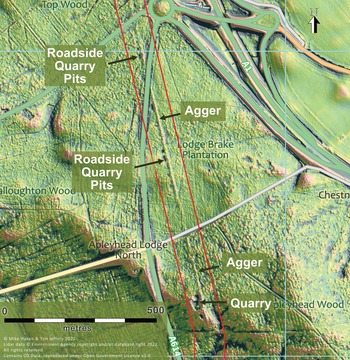
The LiDAR evidence suggests a road leading from the western side of Osmanthorpe fortress heading in a north-westerly direction, with agger, terraceway and cuttings clearly visible in a continuous straight line for 1.76 km below Camp Hill at Kirklington from SK 6726 5688 as far as SK 6646 5844, confirming previous aerial photographic evidence (Notts HER M5485). A section of Roman road on this alignment at Belle Eau Park, Bilsthorpe (SK 660 559) was partially excavated 1999,Footnote 75 and further LiDAR evidence of continuous agger and cuttings now continues the alignment between SK 6588 5958 and SK 6564 6001. The 1999 work had suggested that the road may be heading towards Mansfield; however, thorough examination of LiDAR imagery has revealed no evidence of such a route – instead it seems that it changes alignment near Bilsthorpe church at about SK 6553 6024 to head almost due north. The first part of this new alignment is now obscured by a large colliery spoil heap, but the agger emerges north of it between SK 6561 6232 and SK 6563 6297 crossing fields south of Long Belts Farm, with a possible faint trace on LiDAR immediately north of the farm. An agger on precisely the same alignment can be picked up again at SK6565 6425 running north into New Park Wood, where, on the north side of a slight ridge, the road then makes a minor change of alignment at SK 6568 6489. The new alignment can be picked up again just after the road has crossed the River Maun at Ollerton, (SK 6544 6784), from where it can be traced intermittently on LiDAR for 9.2 km as far as Apleyhead Wood, east of Clumber Park. The modern A614 is clearly following the general Roman line here, although the modern road only overlays the Roman in a few short sections, for example between about SK 6532 6930 and SK 6532 6956. This is an excellent example of the phenomenon of ‘road drift’, where the line of a road moved away from the surveyed Roman line with time, as the original road became impassable due to a lack of repair. Where the road crosses the River Meden near Perlethorpe, a large concentration of Roman finds recorded by the Portable Antiquities Scheme is highly suggestive of a possible settlement site, and two sides of a large defended enclosure can be seen on LiDAR northeast of the crossing.
At Apleyhead Wood the road climbs up a low hill and changes alignment at SK 6473 7712 to head more NNW. The agger can be seen very clearly on LiDAR, as indeed can a row of roadside quarry pits (often regarded as diagnostic of a Roman road), but these are invisible on the ground due to the dense undergrowth in the wood. The new alignment appears to have been followed all the way to Blyth, rather than the curving route taken by the Great North Road. The Roman road is clearly visible on LiDAR at Apleyhead, accompanied by a row of quarry pits set about 30 pedes out from the centre of the road (SK 6473 7712 to SK 6435 7869), and can also be seen at Whin Hill (SK 6361 8181 to SK 6349 8230) and Fleecethorpe (SK 6326 8329 to SK 6303 8429). While there is no clear evidence of the road near Blyth, extrapolation of the alignment takes the road directly to Blyth parish church, which itself aligns perfectly with the next evidence on a new alignment 5.2 km further north, north of Bircotes (SK 6253 9257). Whilst the traces on LiDAR are generally very slight on this new alignment, the road can be seen very clearly on LiDAR in woodland at Martin Beck (SK 6254 9415 to SK 6255 9497). From Martin Beck northwards, the road had already been identified from aerial photography. Crucially, the road does not simply run to the fortress at Rossington; rather it runs past the western defences and crosses the River Torne, where its course was probably marked on the first edition six-inch OS map, marked simply ‘course of old road’. The road disappears into modern Doncaster and cannot be traced further.
In conclusion, the many traces of possible Roman road apparent on LiDAR imagery between Osmanthorpe and Rossington when combined become clear fragments of a continuous line representing a Roman road between the two sites (fig. 38). The route was surveyed in classic Roman fashion, using high ground as sighting points. The implications of this discovery cannot be overstated, since this road, which clearly continued north of Rossington, could potentially have been the primary route north into Brigantian territory, rather than the route from Lincoln via Littleborough (Segelocum) as is usually assumed. This road has been awarded the number RR282(x).
LiDAR image showing the Roman road RR282(x), with accompanying roadside quarry pits and a larger roadside quarry. The modern map overlay shows clearly how the modern road network cuts through it. (Base LiDAR data © Crown Copyright 2020)

OXFORDSHIRE
(1) Chinnor, Greenwood Avenue (SP 75346 00264):Footnote 76 a trial-trench evaluation comprising 15 trenches was targeted on geophysical anomalies. Archaeological features were recorded in four trenches within the north-western part of the site, including an enclosure ditch and a possible well of middle Roman date. The enclosure may represent the focus of a middle Roman settlement. The enclosure ditch was encountered in three trenches and contained 2.7 kg of Roman pottery. In two of these trenches, multiple ditches were present, suggesting that the boundary may have been redefined or maintained over time. Another ditch was recorded parallel and c. 15 m east of the enclosure ditch and this may have defined a droveway. A possible well containing middle and later Roman pottery was recorded in the northernmost trench within the enclosure. Roman activity on this site probably began in the first half of the second century a.d. and the settlement had access to imported Gaulish wares, providing evidence of Romanised dining practices. The environmental samples indicated good preservation of animal bones and charred plant remains, including the presence of spelt wheat.
(2) Didcot, south of the B4016 (SU 5374 9232):Footnote 77 an archaeological strip, map and record excavation was undertaken within a wider development site to the northeast of Didcot. The excavation identified a system of Roman ditches probably associated with agricultural or horticultural activity. The system comprised multiple parallel, NNE to SSW aligned ditches, along with a smaller number of ditches on a WNW to ESE alignment, including a boundary ditch that had been recut several times. The ditch system may be related to a double-ditched trackway on a WNW to ESE alignment that was recorded on the geophysical survey immediately south of the excavation area. The pottery recovered from the excavation is generally of mixed Roman date and, together with the limited range of other find types, attests to the agricultural nature of the landscape. Slight concentrations of ditches, pits and post-holes containing greater quantities of pottery in the north-west of the excavation area may be suggestive of nearby occupation activity. Cropmarks immediately to the north-west of the site may relate to settlement and trackways of possible later prehistoric or Roman date. Together with the recovery of Roman finds, including coins and pottery, to the north of the B4016 during the late nineteenth century, the excavation results suggest that the site lay on the edge of a larger occupation site that extended northwards and north-westwards.
(3) Harpsden, High Wood (SU 75117956): over seven seasons of excavations (between 2015 and 2021) South Oxfordshire Archaeological Group (SOAG) investigated the remains of a Romano-Celtic Temple complex with the ambulatory and cella set within a rectangular temenos enclosure which encompasses a range of at least three rooms. These rooms appeared to have been of low–middle status with a concrete flooring. Room 2 had no tessellation or hypocaust heating which was probably supplied by a brazier. The buildings appear to have suffered a catastrophic collapse into a solution sinkhole in antiquity. The complex overlies evidence of Late Iron Age/Early Romano British exploitation of the site. The site has been subject to the depredations of illegal metal detectorists over the last 40 years and there was clear evidence of ‘antiquarian’ excavation which had removed stratigraphy and, possibly, much artefactual evidence. Fortunately, the sinkhole had not been excavated previously and the undisturbed fill contained a range of ‘votive’ coins which had collapsed into it from the cella area and dated from early second century to the late fourth (a.d. 367). Also, of note, this fill contained a white-patinated pointed and flaked ovate hand axe of Palaeolithic or Neolithic date. Other possibly ‘votive’ finds of note were four encrusted masses of Roman chain mail and fragments of over 60 quernstones. Despite the difficulties of working in a woodland setting, much of the plan has been established and the close proximity of the ambulatory and cella to a range of buildings in the temenos wall is noteworthy. The southern part of the site had been destroyed with no remaining structures, but a buttressed entrance way was found in the eastern wall. Two hundred and nine coins have been recovered, dating from the Late Iron Age to mid-fourth century, which suggests that the religious significance of the site endured throughout the Roman period. However, dating of the excavated buildings is uncertain, depending solely on interpretation of the lower cutaway inserts of the tegulae (roof-tiles) which comprise Warry types 4 and 5 (a.d. 160–260) and Warry types 1, 15 and 16 (a.d. >240). There was no evidence of earlier phases of construction.
RUTLAND
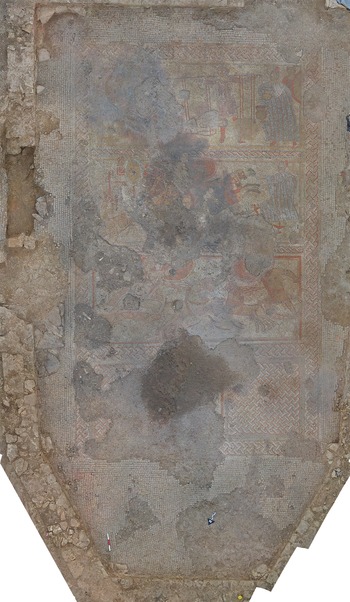
(1) Ketton, Stamford Road (SK 967 031):Footnote 78 a new Roman villa was identified in 2020 following initial discovery and limited investigation by a local landowner. Work in 2021 by University of Leicester Archaeology Services (ULAS),Footnote 79 funded by Historic England, involved recording of the initial landowner excavation, which had revealed part of a figurative mosaic, geophysical survey of the wider area by SUMO Surveys Ltd and trial-trench excavations that targeted some of the survey results. In 2021 ULAS returned to the site to complete the excavation of the mosaic as part of a training excavation. This work revealed a large rectangular mosaic in a well-defined room measuring c. 11 m × 7 m with an apse at one end (fig. 39); the room was probably a triclinium, or dining area, at the northern end of a complex-looking villa dwelling. The geophysical survey was exceptional in showing in clear detail the villa complex, which consists of a range of buildings including the main domestic focus, aisled barns, possible bath-houses and circular structures, all contained within a multiple ditched boundary system. Finds recovered during the limited work to date have indicated a third- or fourth-century a.d. date for the occupation of the villa. The mosaic itself is unique in being the first example from Britain to depict scenes from the Trojan War.
Ketton, Stamford Road: newly discovered villa mosaic depicting scenes from the Trojan War. (© University of Leicester Archaeological Services)

The mosaic is arranged into three panels that illustrate, in comic-book form, the battle between Achilles and Hector towards the end of the Iliad as told by Homer. The orientation of the mosaic was designed to be viewed from the apse, which was plainly decorated and presumably where guests were seated. The nearest panel to the apse shows the battle between Achilles and Hector on chariots; the middle panel shows the victorious Achilles dragging Hector's body behind his chariot while King Priam, Hector's father, looks on in despair. Finally, the gruesome last part of the story is shown on the third panel, where a seated Achilles looks on as Priam loads gold vessels onto a massive pair of scales to counterbalance the weight of the dead Hector. In this scene, which is a departure from the Homeric version of the story, Achilles is releasing the body of Hector, but only for his weight in gold. Areas of the mosaic were burnt and damaged subsequent to the room going out of its original use, and two human burials were found within the rubble filling the apse. It is hoped that radiocarbon dating will help shed further light on the time at which the later activities took place. The villa is now a Historic England Scheduled Monument (National Heritage List entry: 1477234).
SHROPSHIRE
(1) St George's and Priorslee, Further excavations at Uxacona (SJ 7300 1025):Footnote 80 excavation was undertaken in advance of a residential development on the edge of the scheduled Roman town of Uxacona (National Heritage List entry: 1003811), east of Telford and within the parish of St George's and Priorslee.Footnote 81 Geophysical survey and subsequent trial-trenching had identified that part of the settlement's boundary ditch extended into the extreme north-eastern corner of the development site adjacent to Watling Street. The mitigation excavations revealed no evidence for the first- and early second-century military phase evident to the north of Watling Street, which suggests that the road was the southern boundary of the military phase. The south-western corner of the second-century settlement at Uxacona was represented by three ditches: two, intercutting, aligned north–south, and a third aligned WNW to ESE. Like the area of settlement directly to the north of Watling Street, activity in the mitigation area also diminished in the mid-third to late fourth century, reflecting a demise in both Uxacona and its mansio. A short-lived well and several pits were recorded outside the enclosed area, but the paucity of external features corroborates previous geophysical interpretation that the settlement probably did not continue past the southern boundary of the scheduled area.Footnote 82, Footnote 83
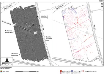
(2) Uffington, Marching Camp (SJ 5246 1287):Footnote 84 Historic England conducted aerial mapping and caesium magnetometer and Ground Penetrating Radar (GPR) surveys over the site of a previously identified temporary Roman campFootnote 85 (fig. 40). The work was designed to further understanding of the site's regional and national significance. The camp is one of a number known as cropmarks in the vicinity of Wroxeter. A rectangular enclosure, 520 m by 380 m, covers an area of about 18 ha, and from the cropmark evidence appears to have been reoccupied at least once at which time it expanded or contracted in size by 50 m east–west. The camp is overlain by a series of later field boundaries and ridge-and-furrow ploughing, but the majority now lies in a single arable field west of the A49. In 1989 a small trial-trench confirmed two curving, 0.65 m deep, V-sectioned ditches associated with the northern corner of the camp, undated but cut through an earlier, shallower curving ditch also lacking dating evidence but presumed to be prehistoric.Footnote 86, Footnote 87 Vehicle-towed caesium magnetometer survey covering 30 ha in 2021 revealed anomalies associated with the camp ditches, including discontinuities in the response that may represent offset entrances to both the north and south of the site.Footnote 88, Footnote 89 Limited occupation evidence was identified within the camp beyond some sparsely distributed groups of likely pits and thermoremanent anomalies. A possible polygonal, ditched enclosure of uncertain date (not visible as a cropmark) was also identified immediately beyond the camp to the north. The GPR coverage (16 ha) corroborated the response to the camp ditches, although the data were partially obscured by the presence of linear anomalies on a similar alignment, possibly due to later agriculture. Both techniques identified wide networks of land drainage together with a previously known pond and removed field boundaries that, in places, hampered the interpretation of more subtle archaeological anomalies.
Linear greyscale image and interpretation of the caesium magnetometer data from the Roman camp at Uffington, Shropshire. (© Historic England)

SUPPLEMENTARY MATERIAL
For supplementary material for this article please visit https://doi.org/10.1017/S0068113X22000423