


Introduction
The Hintang (Lao for ‘standing stone’) archaeological complex in Houaphanh Province, Laos, represents one of Southeast Asia’s most significant megalithic landscapes. Early archaeological research was conducted by Madeleine Colani (Reference Colani1935), who suggested that the standing stones, some of which exceed 3m in height, were associated with mortuary rituals, based on the discovery of underground, stone-lined cists containing human remains (Colani Reference Colani1935: vol. 1, 82–84). Colani posited a Southeast Asian Bronze Age date for the sites (c. 1700–500 BCE), several hundred years earlier than the megalithic jar sites further south in Xieng Khouang Province, based on associated artefacts including bronze vessels and ornaments, glass beads, ceramic vessels and distinctive perforated schist pendants (Colani Reference Colani1935: vol. 1, 87; Shewan & O’Reilly Reference Shewan and O’Reilly2019: 521). A Bronze Age date for the Hintang complex would place it among the earliest known megalithic cultures in mainland Southeast Asia. Following Colani’s pioneering investigations, 72 sites were surveyed (Keosopha & Källén Reference Keosopha and Källén2008) and more than 1500 mica-schist slabs and 150 associated stone discs were recorded (Källén Reference Källén2015: 27). The standing stones are arranged in groups and are frequently positioned along mountain ridges and saddles, offering views across the surrounding valleys. Many examples have been affected by wildfires, forest clearance activities, development and industry, leaving them in areas denuded of vegetation or, in some instances, resulting in their relocation. As part of a new research programme, surveys and an excavation were undertaken in 2025 to geolocate the sites described by Colani, Keosopha and Källén, document new discoveries, recover associated material culture and obtain the first radiometric dates for these sites.
Survey of Hintang sites
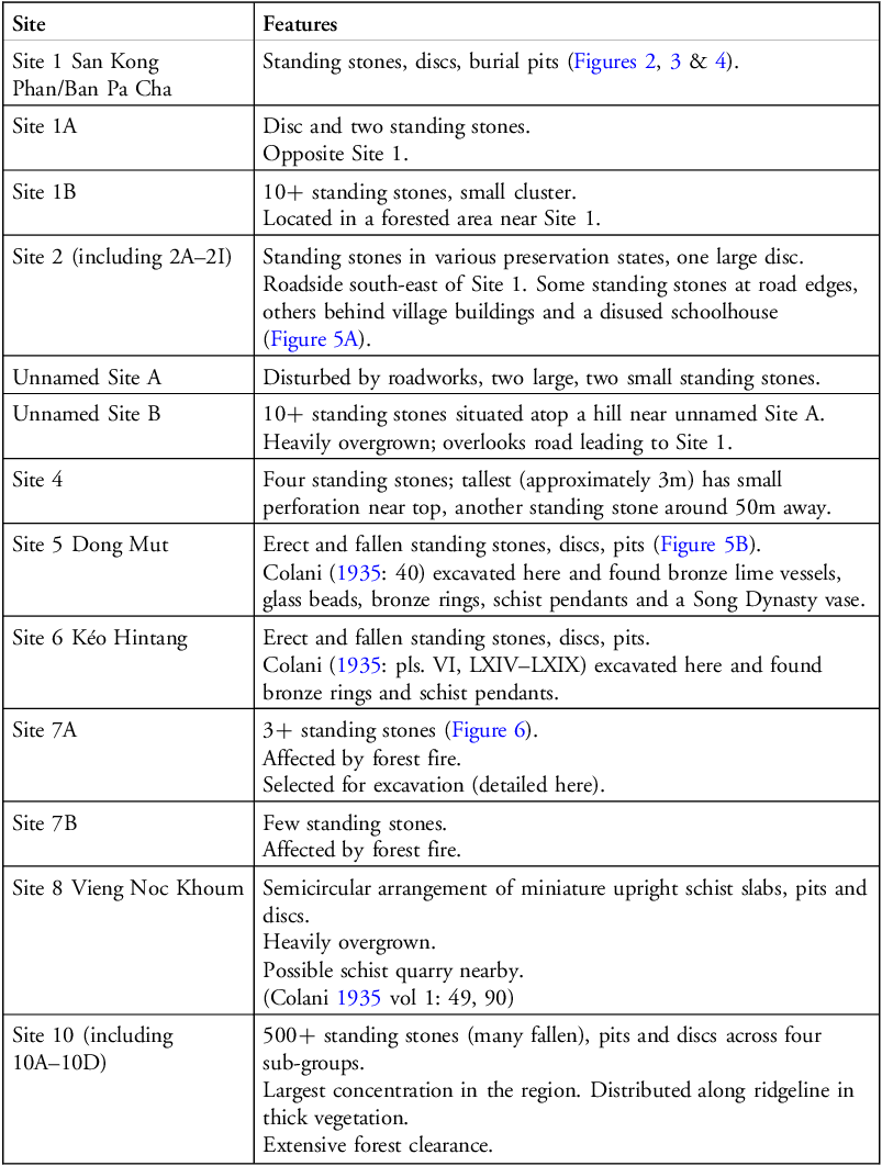
The Lao-Australian archaeological team conducted a comprehensive survey of the Hintang sites in collaboration with the Lao National, Provincial and District Departments of Heritage. Using Real-Time Kinematic (RTK) positioning technology and Unmanned Aerial Vehicle (UAV) documentation, the team systematically recorded the locations of standing stone groups across numerous sites (Figures 1, 2, 3, 4 & 5; Table 1).
Locations of Hintang standing stone sites and survey map (figure by authors).

Site 1 Houaphanh (photograph by authors).

Site 1 standing stones (photograph by authors).

Site 1 discs (photograph by authors).

A) Site 2C; B) Site 5 (red arrow pre-existing) (photographs by authors).

Sites recorded during the 2025 survey.

Table 1 Long description
The table presents a detailed list of archaeological sites and their respective features. It includes two columns: Site and Features. The Sites column lists the names of the sites, while the Features column describes the notable elements found at each site. The table contains 13 rows and 2 columns. Row 1: Site 1 San Kong Phan/Ban Pa Cha, Standing stones, discs, burial pits (Figures 2, 3 & 4). Row 2: Site 1A, Disc and two standing stones. Row 3: Site 1B, 10+ standing stones, small cluster. Located in a forested area near Site 1. Row 4: Site 2 (including 2A–2I), Standing stones in various preservation states, one large disc. Roadside south-east of Site 1. Some standing stones at road edges, others behind village buildings and a disused schoolhouse (Figure 5A). Row 5: Unnamed Site A, Disturbed by roadworks, two large, two small standing stones. Row 6: Unnamed Site B, 10+ standing stones situated atop a hill near unnamed Site A. Heavily overgrown; overlooks road leading to Site 1. Row 7: Site 4, Four standing stones; tallest (approximately 3m) has small perforation near top, another standing stone around 50m away. Row 8: Site 5 Dong Mut, Erect and fallen standing stones, discs, pits (Figure 5B). Colani (1935: 40) excavated here and found bronze lime vessels, glass beads, bronze rings, schist pendants and a Song Dynasty vase. Row 9: Site 6 Kéo Hintang, Erect and fallen standing stones, discs, pits. Colani (1935: pls. VI, LXIV–LXIX) excavated here and found bronze rings and schist pendants. Row 10: Site 7A, 3+ standing stones (Figure 6). Affected by forest fire. Selected for excavation (detailed here). Row 11: Site 7B, Few standing stones. Affected by forest fire. Row 12: Site 8 Vieng Noc Khoum, Semicircular arrangement of miniature upright schist slabs, pits and discs. Heavily overgrown. Possible schist quarry nearby. (Colani 1935 vol 1: 49, 90). Row 13: Site 10 (including 10A–10D), 500+ standing stones (many fallen), pits and discs across four sub-groups. Largest concentration in the region. Distributed along ridgeline in thick vegetation. Extensive forest clearance.
Excavation
The site labelled 7A (Keosopha & Källén Reference Keosopha and Källén2008) was chosen for the first excavation of a Hintang site in 90 years. Located at 20°8′46.46″N, 103°52′2.50″E at an elevation of 1430m above sea level (asl), the site hosts a group of three mica-schist standing stones in a denuded area, vulnerable to further destruction. A 2 × 2m excavation unit was laid out to the south of the stones, one of which was still upright, and excavation proceeded in arbitrary 0.10m spits, with soil sieved through a 5mm screen (Figure 6).
Site 7A: A) trench layout; B) level 1:4; C & D) schist pendant; E) standing stone base (figure by authors).

Excavation, which reached a depth of 0.50m, revealed low-fired earthenware sherds with a fine-quartz temper, some decorated with incisions, and a perforated stone disc with an incised stelliform pattern, measuring 43mm in diameter and 9mm thick (Figure 6C & D). Colani reported finding 28 similar perforated discs at Kéo Hin Tan, San Kong Phan and Dong Mut, all with stelliform patterns, which she believed were contemporaneous with the standing stones (Colani Reference Colani1935: pls. LXIV–LXIX; Shewan & O’Reilly Reference Shewan and O’Reilly2019: 381–86). The disc from Site 7A was discovered atop a fragment of a glazed stoneware bowl. The bottom portion of the vessel, with the foot ring intact, is decorated with an iron-painted abstract design. Ceramic expert Naho Shimizu (pers. comm. March 2025) suggests a Thai origin, dating to the fifteenth–sixteenth centuries CE. If the discs date to the Bronze Age, as Colani believed, the location of the recently excavated disc suggests that the site had been disturbed. Colani similarly reported site disturbance during her excavations, noting the occurrence of more recent vessels and recounting stories from local villagers about long-ago ‘treasure hunters’ (Colani Reference Colani1935: vol. 1, 41–42, 88; Shewan & O’Reilly Reference Shewan and O’Reilly2019: 42, 101). Källén, however, also considers that the more recent items may speak to a complex and long-term site use (Källén Reference Källén2015: 29).
The excavation unit also contained a feature with several mica-schist slabs, perhaps fallen or broken standing stone fragments, with boulders atop them. Ceramic sherds were found within the feature. The schist slabs showed reddened edges, indicating heat exposure and, beneath them, further charcoal was found along with roughly shaped pieces of red and white quartz (40–60mm long). Elsewhere in the unit, an elongated piece of off-white metamorphosed rock with an anthropogenic groove just past its midpoint was found.
The north-west corner of the unit exposed the bases of two standing stones. A 0.60 × 0.60m test pit was excavated to determine the depth to which they were sunk (Figure 6E) and to obtain samples for optically stimulated luminescence (OSL) dating. Rocks were found arrayed around the base of the large standing stone, approximately 0.80m below the ground surface. At 0.78m below the surface, a small charcoal fragment was encountered and is currently undergoing analysis. Three OSL cores were taken beneath the smaller standing stone at 0.10m intervals. One OSL core was taken east of the larger standing stone at 1429.04m asl (around 0.68m below surface), as deeper sampling was not possible. Results will be presented in a future publication.
Conclusion
Field survey and excavation were conducted to generate accurate geolocations for known standing stone sites, document previously unknown sites, identify associated material culture and obtain samples for radiometric dating. The surveys also highlighted the fragility of the sites and the ongoing threats posed by both natural and human activities. Excavation at Site 7A revealed relatively shallow deposits with sparse evidence for human activity, but it helps clarify how the standing stones were erected. Approximately one-third of each standing stone’s height was placed in a pit, in a ratio consistent with the widely used rule of thumb derived from empirical structural practice (Bowles Reference Bowles1996). Smaller stones were used to hold the standing stone in place, and the pit was backfilled with earth. Bioturbation has erased any visible trace of pit cuts. Future research will focus on further excavation and geospatial mapping to document this important megalithic landscape.
Acknowledgements
We are grateful for the support and collaboration of our Lao colleagues Ansomone Inthichack, Anusone Milakham (Provincial MoICT), and Souksamone Sayyasane (District MoICT) and the Chief of Ban Tao Hin, Mr Davun. Special thanks also to Jamie Speer and Paul Howard for their assistance in the field.
Funding statement
This research is funded by the Australian Research Council (DP230100033). Shewan is also supported by Rock Art Australia.
Author contributions: CRediT categories
Louise Shewan: Conceptualization-Lead, Data curation-Supporting, Formal analysis-Equal, Funding acquisition-Equal, Investigation-Equal, Methodology-Equal, Project administration-Lead. Dougald O’Reilly: Conceptualization-Equal, Data curation-Equal, Formal analysis-Equal, Funding acquisition-Equal, Investigation-Equal, Methodology-Equal, Project administration-Equal. Brian Armstrong: Conceptualization-Supporting, Data curation-Equal, Formal analysis-Equal, Funding acquisition-Supporting, Investigation-Equal, Methodology-Equal, Project administration-Supporting. Amphai Butphachit: Conceptualization-Supporting, Data curation-Supporting, Formal analysis-Supporting, Funding acquisition-Supporting, Investigation-Supporting, Methodology-Supporting, Project administration-Supporting, Validation-Equal.




 Open access

