INTRODUCTION
Aridity affects the structure and functioning of dryland ecosystems (Berdugo et al., Reference Berdugo, Delgado-Baquerizo, Soliveres, Hernández-Clemente, Zhao, Gaitán and Gross2020). Desertification and degradation are pervasive in drylands, owing to global warming and the effects of rapid economic development, population growth, and urbanization (Huang et al., Reference Huang, Yu, Guan, Wang and Guo2016). Many previous studies have attributed desertification to overgrazing, overfarming, land misuse, and population pressures (Wang et al., Reference Wang, Chen and Dong2006; Zhang and Deng, Reference Zhang and Deng2019). Dryland landscapes reflect an interplay of diverse factors such as climate, topography, and human intervention (Bürgi et al., Reference Bürgi, Hersperger and Schneeberger2004), and reconstructions of past environments need to recognize the spatial variability in these environments (Thomas and Burrough, Reference Thomas and Burrough2012; Lancaster et al., Reference Lancaster, Yang and Thomas2013). Thus, a multidisciplinary approach to understanding the drivers and feedbacks of desertification is urgently needed in the context of climate change (Huang et al., Reference Huang, Wang, He, Cheng and Zhao2009b; D'Odorico et al., Reference D'Odorico, Bhattachan, Davis, Ravi and Runyan2013; Li and Yang, Reference Li and Yang2016; Yang et al., Reference Yang, Liang, Zhang, Li, Rioual, Wang and Xu2019).
Over the past several decades, environmental changes in the Mu Us Desert have been actively researched. Widespread eolian sand and paleosol sequences in this region are archives for studying desert environmental changes (Lu et al., Reference Lu, Miao, Zhou, Mason, Swinehart, Zhang, Zhou and Yi2005; Mason et al., Reference Mason, Lu, Zhou, Miao, Swinehart, Liu, Goble and Yi2009; Liang and Yang, Reference Liang and Yang2016; Liu et al., Reference Liu, Jin, Sun, Sun, Niu and Cai2016, Reference Liu, Lu, Lü, Du, Jia, Li, Chen and Wu2017; Wen et al., Reference Wen, Li, Zheng, Yang, Niu and Shu2016; Liu and Yang, Reference Liu and Yang2018). Researchers from different academic perspectives have studied environmental problems in the Mu Us Desert. Consequently, three viewpoints, based on different methods, exist regarding the causes of desertification: (1) Quaternary researchers advocate that natural factors, especially centennial-scale climate change, play a leading role in the desertification of the Mu Us Desert (Dong et al., Reference Dong, Gao, Jin and Li1989; Li et al., Reference Li, David, Jin, Zheng, Yan, Wu, Zhu and Sun2000, Reference Li, Wang, Liu, Zhang and Han2019; Wang et al., Reference Wang, Chen, Dong and Xia2010; Zhou et al., Reference Zhou, Lu, Zhang, Mason and Zhou2010; Jia et al., Reference Jia, Lu, Gao, Li and Liu2015; Xu et al., Reference Xu, Lu, Yi, Vandenberghe, Mason, Zhou and Wang2015). (2) Some researchers emphasize that human activities are the dominant factor in the formation of the Mu Us Desert (Hou, Reference Hou1964, Reference Hou1973, Reference Hou2007; Zhu, Reference Zhu1982; Miao et al., Reference Miao, Jin and Cui2016; Guo et al., Reference Guo, Xiong, Wu, Ding, Chen, Zhu and Ye2018). (3) Other researchers view the problem from the perspective of historical geography, believing that the formation of the Mu Us Desert is a result of the superposition and interaction of natural and human factors (Deng et al., Reference Deng, Shu, Song and Xing2007; Huang et al., Reference Huang, Wang, He, Cheng, Feng and Long2009a; He and Wang, Reference He and Wang2010; Cui and Chang, Reference Cui and Chang2013; Lu et al., Reference Lu, Yi, Xu, Zhou, Zeng, Zhu and Feng2013; Wang et al., Reference Wang, Cheng, Li, Lou, Hua, Liu, Jiao, Ma, Li and Zhu2017).
Studies of the Hunshandake Sandy Land in northeast China have shown that an irreversible and abrupt desertification was triggered by changes in the hydrologic system. Groundwater sapping contributed to the post–Humid Period mass outmigration of northern China's Neolithic cultures (4.2 ka). (Yang et al., Reference Yang, Scuderi, Wang, Scuderi, Zhang, Li and Steven2015). In arid and semiarid areas, access to water is a basic requirement for human settlements. As such, the locations of ancient settlements are an important source of information about the historical hydrologic environment. This study used fluvial incision at the site of the ancient city of Sanchahe in China's Mu Us Desert to assess the impact of geomorphological change on environment changes in the Wuding River basin. The results provide a new perspective for the study of environmental change, especially desertification, in the southern Mu Us Desert.
STUDY AREA
The Mu Us Desert (Fig. 1) is located in the southern part of the Ordos Plateau and is a typical ecological transition zone in northern China. The unique natural setting determines the fragility and vulnerability of its environment. The area lies within the northwestern marginal zone of the East Asian summer monsoon system, where vegetation, soil, and eolian sand respond rapidly to external disturbances (Sun et al., Reference Sun, Li, Han and Chen2006). The mean annual temperature is 6.0°C–9.0°C, and the mean annual precipitation ranges from 250 mm in the west to 420 mm in the east, with more than 60% of the annual precipitation occurring from July to September (Sun, Reference Sun2000; Wu and Ci, Reference Wu and Ci2002).
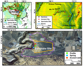
Geographic environment of the ancient city of Sanchahe in China. (a) Location of Sanchahe. (b) Map of the Mu Us Desert and Wuding River basin. The black dot represents the sections along the Wuding River, Dagouwan, Dishaogou, Milanggou. The red dots represent the ancient city site near the Sanchahe: 1, Youzhou; 2, Xiazhou (Tongwan city); 3, Yinzhou; 4, Suizhou. (c) Detailed satellite image of Sanchahe (Google Earth, 2010); solid orange lines outline residual city walls still clearly visible, and the dotted orange line marks the location of the western city wall, which was destroyed by fluvial incision of the Wuding River. The irregular purple outline roughly depicts distribution of cultural relics. (For interpretation of the references to color in this figure legend, the reader is referred to the web version of this article.)

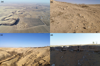
The ancient city of Sanchahe (37°46′27.22″N, 108°34′50.58″E) is located on a terrace beside the Wuding River, in the southern Ordos Plateau (Figs. 1c and 2a). The eastern and western walls are ~320 and ~540 m long, respectively, and the northern and southern walls are ~660 and ~670 m long, respectively. All walls are ~10 m wide. Relics, such as pottery pieces and black tiles, are scattered on the surface of the site (Figs. 1c and 2b). Traces of entrenchment, such as broken bricks, black tiles, and bone pieces, are visible on the western side of the northern wall. According to reports from archaeologists, these pottery pieces, broken bricks, and black tiles are mainly from the Song (Xixia) and Yuan dynasties (AD 960–1368) (Bureau of National Cultural Relics, 2003). Based on archaeological findings and the literature, researchers have speculated that Sanchahe city was the Chahannaoer city (prince's palace) during the Yuan dynasty (He and Wang, Reference He and Wang2010). Chahannaoer is a Mongolian word meaning “white lake,” suggesting that when the city was built, it was bordered by a lake. During the Yuan dynasty, the Ordos Plateau did not need military defense, so attention was paid to the environment when building a city. The rivers and lakes beside the ancient city constitute the landscape of the site selection. Thus, the historical environment of the city was presumably beautiful and hospitable. But at present, a fixed sand layer covers the southern side of the city and includes semi-fixed sand dunes. On the west side of the ancient city is the Wuding River, which originates from Baiyu Mountain in Yulin, Shaanxi Province, and flows through the southeastern part of the Mu Us Desert (Fig. 1b). It is a tributary of the Yellow River and the largest river in this region. Tamarix chinens, hongliu in Chinese, was growing abundantly in the valley during the historical period, so people also called the upper reaches of the Wuding River the Hongliu River. Owing to the incision of the Wuding River, part of the western wall of the city has collapsed. The slope below the city wall has an incline of 37° and is ~65 m high (Fig. 2c). A gray-white Holocene lacustrine deposit in the upper strata of the slope is clearly visible (Fig. 2d). There are only a few villages, all with low population densities, on both sides of the modern Wuding River. Due to the low groundwater level, agricultural production mainly relies on deep well irrigation.
(color online) Environment of Sanchahe site. (a) Aerial photograph from the southern side of the ancient city. (b) Pottery pieces and black tiles scattered on the surface. (c) Huge slope on the western side of the ancient city. (d) Gray-white Holocene lacustrine deposit in the upper strata of the slope.

MATERIALS AND METHODS
Field and laboratory work
The Sanchahe site is located on the outside edge of a meander of the Wuding River, and the western side of the ancient city has been eroded by the river, resulting in the formation of a high slope (Fig. 2c). Scientific expeditions have revealed and measured an ancient well and exposed spring on this slope. A piece of wood collected at the bottom of the ancient well was analyzed using accelerator mass spectrometry (AMS) 14C dating. Furthermore, we cleaned a 3-m-high profile at the top of the slope and collected three AMS 14C samples at different depths. In addition, we interviewed the villagers near the ancient city, mainly about the current protection and the groundwater level condition of the ancient city.
These collected samples were dated at the Laboratory of Science Technological Archaeology & Cultural Relics Protection at Peking University. The 14C era corrections were based on the IntCal13 calibration curve (Reimer et al., Reference Reimer, Bard, Bayliss, Beck, Blackwell, Ramsey and Buck2013). Grain-size analyses were performed using a Mastersizer 2000 laser particle size analyzer (Malvern Instruments, UK), with a measuring range of 0.02–2000 μm, in the Key Laboratory of West China's Environmental System, Ministry of Education, Lanzhou University. The pretreatment process was based on the chemical treatment methods of Konert and Vandenberghe (Reference Konert and Vandenberghe2010).
Historical document analyses
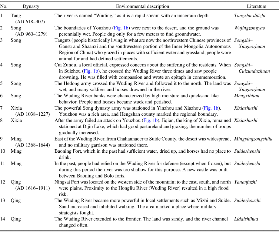
Historical documents were used to obtain additional information about environmental changes in the study area. We collected historical records of the Sanchahe site and its surrounding areas from the literature, including historical records of the Wuding River basin (Table 1). Although the historical data were relatively discrete, they nonetheless provided useful reference material. By interpreting the historical records, we improved our understanding of the process and causes of historical desertification in the area. In addition, using the historical settlement data published in the Atlas of Chinese Cultural Relics (Bureau of National Cultural Relics, 1998, 2003, 2010), we conducted a spatiotemporal analysis of human archaeological sites in the upper reaches of the Wuding River basin, in the Mu Us Desert. Finally, we conducted historical seismic analyses to explore the reason for fluvial incision. The seismic data set was provided by the China Earthquake Data Center (http://data.earthquake.cn).
Historical records for Sanchahe site and Wuding River Basin.

RESULTS
Profile description and chronological framework
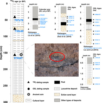
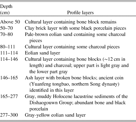
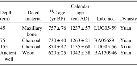
The profile could be divided into three parts: cultural layers, sand layers, and lacustrine sediment (Fig. 3, Table 2). The cultural layers contain black tiles, animal bones, charcoal, and bricks. At a depth of 146–165 cm, we found an ancient coin (Yuanfeng tongbao, AD 1078–1085) from the northern Song dynasty (Fig. 3), which provided a relative date for the ancient city. Grain-size analyses showed that all three sand layers could be eolian, indicating that there was a desert before the city was built. In addition, the cultural layer was above the lacustrine sediment, indicating that there were lakes here before the city was built. Therefore, the age of the lacustrine sediment layer is an important factor in analyzing the paleoenvironmental changes in this area. The 14C-dating results (Table 3) and the ancient coin indicate that the ancient city was well established during the Song (Xixia) and Yuan dynasties (AD 960–1368).
Stratigraphic sections of the Sanchahe site with their dating results. The red circle in the photograph marks the ancient coin (Yuanfeng tongbao). The Dishaogou section is redrawn after Liu et al. (Reference Liu, Lu, Jia, Chen, Li, Ma and Wu2018), Zhao et al. (Reference Zhao, Sheng, Li and Fan2016), and Liu and Lai (Reference Liu and Lai2012); and the Dagouwan section is redrawn after Li et al. (Reference Li, Li and Wintle2008). OSL, optically stimulated luminescence. (For interpretation of the reference to color in this figure legend, the reader is referred to the web version of this article.)

Characteristics of profile layers in the slope on the western side of the Sanchahe site.

Radiocarbon ages for the Sanchahe site.

To better understand past environmental changes in this area, we compared previous research on stratigraphic sections along the river (Figs. 1b and 3), the Dishaogou section (Liu and Lai, Reference Liu and Lai2012; Zhao et al., Reference Zhao, Sheng, Li and Fan2016; Liu et al., Reference Liu, Lu, Jia, Chen, Li, Ma and Wu2018) and the Dagouwan section (Li et al. Reference Li, Li and Wintle2008). These two sections are located upstream of the study area and are very close to the Sanchahe site. Chronological results indicated that the lake and swamps likely existed from the middle Holocene to the late Holocene in the upper reaches of the Wuding River basin, and the age at the top of the lacustrine sediment layer was 1.2 ka. Studies at Milanggou (37°46′N, 108°32′E) are consistent with this dating; the 14C age at the top of the lacustrine sediments (more than 60 m above the modern river surface) is 1067 ± 77 14C yr BP (Li et al., Reference Li, Jin, Zhu, Dong and Wen2004).
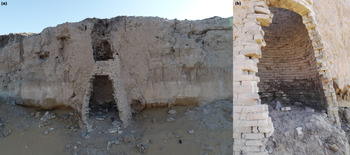
Ancient well
Ancient wells not only supported settled societies but also provide rich information about past environmental conditions (Yu et al., Reference Yu, Chen, Liu, Fang, Guo, Zhan, Fang and Chen2018). Based on the field survey results, we identified an ancient well (37°46′33.71″N, 108°34′46.65″E) in the western area of the Sanchahe site (Figs. 1c and 4) at an elevation of 1278 m above sea level. In the lower part of the bottom brick, we identified wood, and the 14C-dating results (AD 1342) dated it to the Yuan dynasty (Table 3). The ancient well was 2.7 m deep, and the water level reached a depth of 1.25 m below the ground, indicating that during the Yuan dynasty, the groundwater depth was approximately 1.45 m. Historical records verified these observations. The Wujingzongyao book, one of the oldest existing large-scale military books edited by the government during the Song dynasty (Table 1), recorded a groundwater-rich environment at that time: “The boundaries of Youzhou were adjacent to the desert, and the ground was wet perennially. People dug underground for a few meters to find groundwater.” With subsequent environmental and groundwater changes, the ancient well dried up and was abandoned.
(color online) Ancient well of the ancient city of Sanchahe. (a) The location and the surrounding environment of the ancient well and the gray-white lacustrine sediments beside the well are clearly visible. (b) Detailed views of the ancient well. Gray sediments distributed on the inner wall are thought to be a water stain from the period of well usage.

Spring
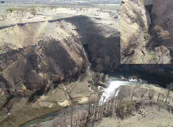
The spring exposed in the lower part of the slope has an elevation of 1243 m above sea level (Figs. 1c and 5). The elevation of the modern riverbed is 1217 m above sea level, and the spring is 26 m above the river surface. The exposed position of the spring is ~35 m below that of the ancient well. The current groundwater level of the ancient city was equivalent to that of the exposed spring, indicating that the groundwater level has dropped by nearly 35 m since the Yuan dynasty. Furthermore, from interviews with residents living on the northern side of the ancient city, the average depth of a modern motor-pumped well in the village is 33 m, confirming that the groundwater level has dropped by nearly 33–35 m over the past 800 yr.
(color online) Spring west of the Sanchahe site. (a) River valley beside the ancient city and (b) modern exposed spring.

Human archaeological site spatial analyses
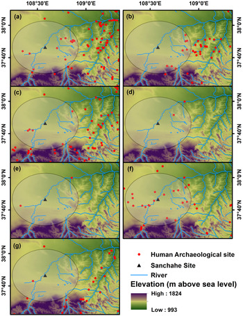
Accurate documentation and mapping of archaeological data contribute to a better understanding of temporal and spatial patterns of human habitation, pathways of cultural and economic exchange, migration routes, and trajectories of social development (Zhang et al., Reference Zhang, Zhao and Liu2007; Wagner et al., Reference Wagner, Tarasov, Hosner, Fleck, Ehrich, Chen and Leipe2013). Based on mapping of the spatial and temporal distribution of human archaeological sites, this study analyzes the buffer zone around the ancient city of Sanchahe to a distance of 30 km (Fig. 6). The historical human activities along the upper reaches of the Wuding River basin are clearly shown.
(color online) Spatial and temporal distribution of human archaeological sites in the upper reaches of the Wuding River basin. (a) Neolithic period (8000 BC–2070 BC); (b) Xia, Shang, and Zhou dynasties (2070–256 BC); (c) Qin and Han dynasties (221 BC–AD 220); (d) Wei, Jin, and Southern and Northern dynasties (AD 220–581); (e) Sui and Tang dynasties (AD 581–907); (f) Song (Xixia) and Yuan dynasties (AD 960–1368); (g) Ming and Qing dynasties (AD 1368–1912). The circle depicts a 30 km buffer zone around the ancient city of the Sanchahe site.

The Neolithic period of northern China is better known because of a longer history of human settlement (Tarasov et al., Reference Tarasov, Jin and Wagner2006; Hosner et al., Reference Hosner, Wagner, Tarasov, Chen and Leipe2016). During the Neolithic period (8000–2070 BC), a suitable climate, as well as the large lake and swamp environment, made this area habitable for humans. After this period, human activity in the area was not very intensive and continued sporadically into the Sui and Tang dynasties (AD 581–907). The Song (Xixia) and Yuan dynasties (AD 960–1368) were periods of relative prosperity, presenting a sharp contrast with the low level of human activity found before and after in this area (Fig. 6f). Most archaeological sites around Sanchahe are dated from around this period or later. The phenomenon of settled human habitation in the study area before this time was unique, which may reflect a response to local environmental changes.
Historical seismic statistics
In terms of the regional geologic structure, the Ordos Plateau, which hosts the Mu Us Desert, is an integral part of the Ordos block, and its hinterland is relatively stable. The Ordos block is a relatively complete uplift area with weak internal deformation (Shi et al., Reference Shi, Dong and Hu2020). However, the basin at the edge and the surrounding mountainous areas of the Ordos block have experienced strong neotectonic movement during the Quaternary (Shi, Reference Shi1991). Earthquake activity is a form of neotectonic movement of the earth, active at some times, less so in others. Through historical seismic analysis, we tried to find the reason for the fluvial incision of the Wuding River.
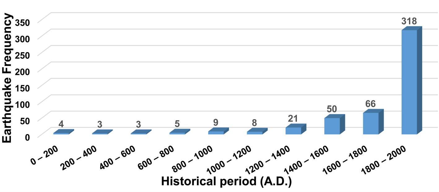
Natural disaster records postdating the western Han dynasty (202 BC–AD 2) are relatively complete (Tong, Reference Tong2002; Liu and Yang, Reference Liu and Yang2012). During the Qin and Han dynasties (221 BC–AD 220), there was much human activity in this area, and earthquakes of a magnitude that humans can perceive are usually recorded. Therefore, we selected earthquakes in the Ordos Plateau and adjacent areas from AD 1 to AD 2000 (M ≥ 4.0; Fig. 7). Historical seismic analysis can be justified, in spite of uncertainties surrounding historical earthquakes in earlier time periods, which may have been recorded less uniformly in these historical documents. The results show that AD 1200 was a turning point, after which the frequency of earthquakes increased dramatically. The results suggest that neotectonic movement since AD 1200 has led to continuous crustal uplift of the Ordos Plateau, accelerating the incision of the Wuding River.
Historical earthquake (M ≥ 4.0) frequencies for the Ordos Plateau and adjacent areas.

DISCUSSION
Fluvial incision of the Wuding River
Alluvial and geomorphological processes are sensitive to tectonic activity (Holbrook and Schumm, Reference Holbrook and Schumm1999; Maddy et al., Reference Maddy, Bridgland and Green2000), and unglaciated topography is shaped by competition between tectonic uplift and bedrock river incision (Finnegan et al., Reference Finnegan, Rina and Seth2014). Many geologists have recognized crustal uplift–driven river terrace formation (Molnar et al., Reference Molnar, Brown, Burchfiel, Deng, Feng, Li, Raisbeck, Shi, Wu and Yiou1994). The structural stability of the ground enables the accumulation of river sediments, and crustal uplift causes rivers to downcut. For example, the terraces of the Weihe River (tributary of the Yellow River) are thought to have formed as a result of multiple periods of crustal uplift (Sun, Reference Sun2005). On the northern margin of the Ordos Plateau, paleo-earthquake activity over the past 20 ka suggests that tectonic activity is the dominant controlling factor in the formation of river terraces in this area (Chen et al., Reference Chen, Fan, Zhang and Fan2013). In addition, previous researchers have concluded that the Wuding River basin was affected by neotectonic movement around ~2 ka, and that the Ordos and Loess Plateaus were generally uplifted (Dong et al., Reference Dong, Li and Gao1983). Tectonically induced incision by the Yellow River forced downcutting of the Wuding River, and that incision worked its way upstream, reaching the Sanchahe site in the late Holocene. Therefore, the groundwater level at the Sanchahe site decreased because of river downcutting. Based on our historical earthquake analyses, we suggest that the strengthening neotectonic movement may have contributed to accelerated fluvial incision of the Wuding River and led to lowering of groundwater levels near the Sanchahe site over the past 800 yr, which likely led to the eventual collapse of the ancient city.
Active extension of stream networks into fully or partially stabilized dune fields is not unusual and can lead to incision downstream (Yang et al., Reference Yang, Scuderi, Wang, Scuderi, Zhang, Li and Steven2015). The stream network extends itself by spring sapping (springs emerging from a sand slope at the upper end of the stream valley undermine the slope and cause the valley to extend upstream, often quite rapidly). This process is widely recognized in the literature and is quite apparent in the Nebraska Sand Hills (Loope et al., Reference Loope, Swinehart and Mason1995; Forman et al., Reference Forman, Oglesby and Webb2001). The spring emerging from the scarp in Figure 5 could eventually form a tributary valley by spring sapping. Tributaries of the Wuding River within the dune field look very much like streams extending by spring sapping (few or no tributaries, an abrupt upper end surrounded by a scarp). Another alternative, but possibly complementary, explanation involves episodic dune blockage of the Wuding River forming lakes or wetlands. The river would then reconnect and extend upstream through spring sapping into the lacustrine and eolian sediments blocking the valley. The present-day dunes are collapsing directly into the Wuding River, and other streams in this area and could block the stream during dry intervals with greater dune activity. The Wuding River basin is ideally located for this to happen, as it flows through the downwind part of the dune field.
The results of this study show that, over the past 800 yr, groundwater levels have dropped by 33–35 m at a rate of ~4.2 cm/yr. In addition, the ancient well is located on the bank of the Wuding River relatively close to the river. Therefore, the historical water level of the ancient well can be approximated as the river water level at that time. The ancient well is ~61 m higher than the current river valley surface. It can thus be inferred that the Wuding River has downcut by ~61 m over the last 800 yr at an average incision rate of approximately 7.6 cm/yr. This information, combined with evidence from the Dishaogou and Dagouwan sections discussed earlier (Fig. 3), indicates that a lake-swamp environment occurred in the middle Holocene and gradually shrank to form a shallow lake environment around 1200 yr BP. The river topography of the area expresses a signature of aridity, indicating that the climate is a dominant factor of the evolution of the drainage basin (Chen et al., Reference Chen, Michaelides, Grieve and Singer2019). Around ~5 ka, the Wuding River basin began to become arid, as inferred from lake regression and fluvial activity. Deposition of fluvial sediments lasted from ~5 ka to ~2 ka. At about 2 ka, incision of the Wuding River into the underlying sediments began (Li et al., Reference Li, Sun and Li2012). Therefore, the new ages from the cultural layer in this study (874 ± 47 cal yr BP) should be viewed as a minimum age for the formation of the river terrace, and the river incision may have occurred earlier than 800 yr ago. According to historical documents (Table 1): “The River is named ‘Wuding,’ as it is a rapid stream with an uncertain depth”; “The Wuding River banks were characterized by high moisture and quicksand-like behavior. People and horses became stuck and perished”; “Wuding River contained a large amount of sediment and mud”. Our results suggest that this river cut through lacustrine sediment layers and deposited a sand layer during the downcutting process, which accelerated the rate of downcutting and increased the sediment concentration of the river. This is consistent with the results of other studies showing that downcutting of the Wuding River has accelerated over the past millennium (Hu et al., Reference Hu, Mo, Wang and Zhang2011). In turn, this downcutting is associated with loose sediments dominated by sand and silt that are highly vulnerable to erosion.
Environmental degradation in the Mu Us Desert
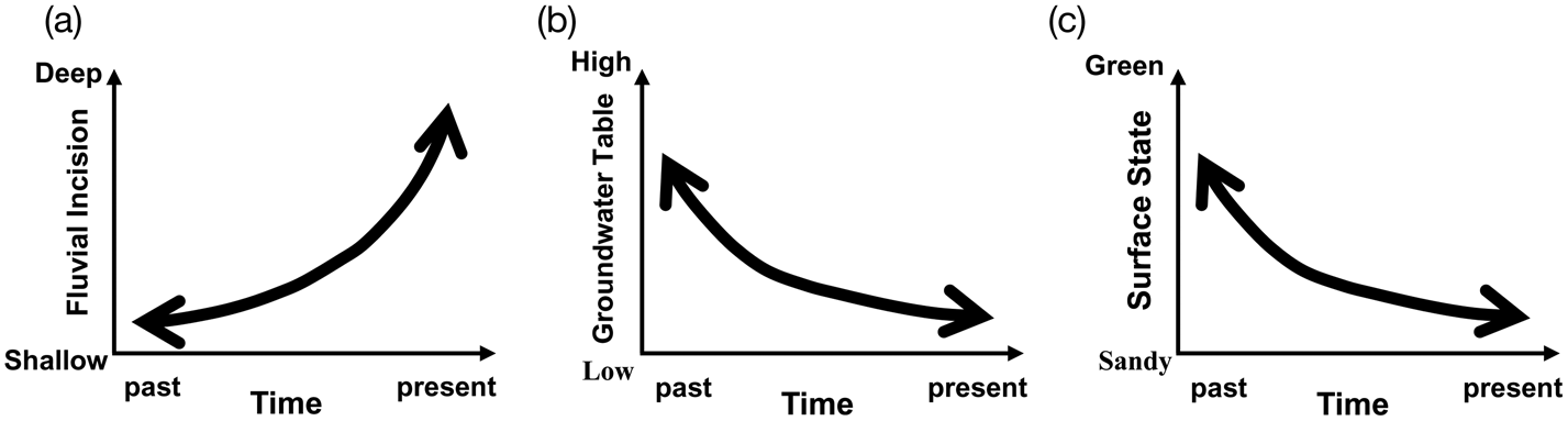
In the present study, we use human archaeological data to assess paleoenvironmental and human dynamics in the Wuding River basin. Environmental changes strongly affected human migration in this area. Researchers have investigated the historical Wuding River and suggested that a large area of lake and marsh existed in the southern Mu Us Desert (Liu et al., Reference Liu, Lu, Jia, Chen, Li, Ma and Wu2018). This is consistent with our field investigation, which identified lake sediments with a thickness of 1 m in the western part of the Sanchahe site. Zhao et al. (Reference Zhao, Sheng, Li and Fan2016) conducted optically stimulated luminescence dating at the top of the lacustrine layer and found that before the city was built, there was a relatively large lake and wetland in the area, which allowed sand dunes to be fixed. During the Song (Xixia) and Yuan dynasties (AD 960–1368), the lake and swamp gradually dried up, and the Wuding River incision was not yet deep, creating suitable living conditions for nomadic tribes. “The Tanguts (people historically living in what are now the northwestern Chinese provinces of Gansu and Shaanxi and the southwestern portion of the Inner Mongolia Autonomous Region of China) who grazed in places with sufficient water and grassland; people wore animal fur and had defined settlements” (Table 1). However, with the enhancement of neotectonic movement and uplift of the crust, the river erosion base level fell, and the rate of river incision increased. The groundwater level near the river gradually decreased, leading to changes in surface vegetation and the lake drying up, resulting in increased desertification (Fig. 8). Dunes are driven by the wind, but the vegetation covering them weakens this impact (Yizhaq et al., Reference Yizhaq, Ashkenazy and Tsoar2007). There is also significant correlation between vegetation coverage, soil infiltration, and the mechanisms of surface production and convergence, which are important factors affecting hydrologic parameters. Generally speaking, the greater the vegetation coverage, the stronger the soil infiltration function and the lower the sediment yield (Eshghizadeh et al., Reference Eshghizadeh, Talebi, Dastorani and Azimzadeh2016). Studies by Seeger (Reference Seeger2007) show that increased vegetation coverage can effectively reduce runoff and sediment yield.
Process of fluvial incision in terms of (a) depth, (b) groundwater level, and (c) surface vegetation change.

Dune systems can have alternative stable states that coexist under certain environmental conditions (Xu et al., Reference Xu, Mason, Xu, Yi, Bathiany, Yizhaq, Zhou, Cheng, Holmgren and Lu2020). Compared with the current environment, the degradation of the environment around the ancient city is mainly manifested in heightened desertification and the deterioration of the hydrologic environment. The latter has had a particularly important effect on the broader Mu Us Desert region. Eolian activities are affected by multiple factors, and climate is often considered a fundamental controlling factor in the geomorphic processes operating at the Earth's surface (Kochel and Miller, Reference Kochel and Miller1997). Cui and Chang (Reference Cui and Chang2013) analyzed the possible effect of climate change on the collapse of Tongwan City (Fig. 1b), an ancient urban city of the Daxia state located to the east of the study area. During the Ming and Qing dynasties (AD 1368–1912), the cold climate of the Little Ice Age may have caused vegetation reduction, leading to the desertification in the Mu Us Desert (Cui et al., Reference Cui, Chang, Cheng and Burr2017). Furthermore, human activities have contributed to vegetation destruction, which reactivated sand dunes and resulted in desertification (Huang et al., Reference Huang, Wang, He, Cheng and Zhao2009b). In a more recent study, Zhang et al. (Reference Zhang and Deng2019) argued that an agricultural boom during the Qin and Han dynasties (221 BC–AD 220), coupled with the dry climate, may have accelerated the climate-driven desertification process after AD 220 in the Mu Us Desert.
According to historical records, “Baoning Fort, which in the past had sufficient water, dried up and horses had no place to drink”; “In the past, people had relied on the Wuding River for defense (except when frozen), but during this period the river was too shallow for this purpose. A new castle was built between Baoning and Bolo Forts” (Table 1). The Wuding River basin became shallower during the Ming dynasty (AD 1368–1644), and the lakes gradually dried up. Due to decreased groundwater in this area, the dried lake basins provided additional sand sources that accelerated desertification. Ai (Reference Ai2012) proposed that since the Yuan dynasty (AD 1271–1368), the Mu Us Desert has been slowly expanding southeastward. During the Wanli period (AD 1563–1620) of the Ming dynasty, the desert extended to the area of the Ming Great Wall. The downcutting of the Wuding River has led to a decline in the groundwater level in the vicinity of the river, which has in turn led to desertification and increasingly serious environmental degradation at the southern margin of the Mu Us Desert.
CONCLUSIONS
Two conclusions can be drawn from this study. First, an ancient well occurs ~61 m above the current river valley surface in the ancient city of Sanchahe. Thus, it can be inferred that the Wuding River has downcut by ~61 m over the last 800 yr, amounting to an average incision rate of 7.6 cm/yr. The enhancement of neotectonic movement over this time period may have contributed to accelerated crustal uplift, resulting in the river cutting through lake sediments and into a sand layer. In turn, this has increased the incision rate.
Second, as a result of the accelerated incision of the river, the groundwater level has dropped by 33–35 m over the past 800 yr at a rate of 4.2 cm/yr. Groundwater decline is an important cause of environmental degradation in and around the ancient city. The original surface-water and groundwater circulation system has completely changed, and the basic conditions for maintaining the original vegetation of the Mu Us Desert have ceased to exist. In addition, the dried lake basins provided an additional sand source for the desertification of this transition zone.
ACKNOWLEDGMENTS
This work was supported by the Key Project of the National Natural Science Foundation of China (grant no. 41530745), the National Natural Science Foundation of China (grant no. 41871021), and the Fundamental Research Funds for the Central Universities (grant no. lzujbky-2019-it28). The authors wish to thank Zhenmin Niu, Lyulyu Zhang, and Kai Ning for their invaluable advice. Two anonymous reviewers and editors helped to greatly improve the article. We would also like to thank Editage (www.editage.cn) for English language editing.