Introduction
What are the driving forces behind large scale natural resource exploitation in the polar regions and how should we understand the relations between these forces? These are two central questions for the LASHIPA project (Large Scale HIstorical exploitation of Polar Areas), a research project carried out within the International Polar Year (IPY) 2007–2009, with participants from the Netherlands, Sweden, USA, Great Britain, Norway, and Russia. In this article we will give some answers to these questions, based on results from six of the subprojects within LASHIPA.
The questions are of central importance for understanding developments in the high Arctic today. Over the last few years, the circumpolar north has become increasingly important as a potential supply area of fossil energy. There are several reasons for this. On the one hand, the Arctic is expected to contain at least 25% of the world's undiscovered hydrocarbon resources (US Geological Survey 2008: Gautier and others Reference Gautier, Bird, Charpentier, Grantz, Houseknecht, Klett, Moore, Pitman, Schenk, Schuenemeyer, Sørensen, Tennyson, Valin and Wandrey2009). On the other hand, over the last few decades, the thickness of the Arctic sea ice has been decreasing. If this tendency continues, the Arctic Ocean may be free of ice in summer within two decades (NSIDC 2009). This offers new possibilities for extracting oil and gas reserves there and for opening up new shipping routes between the Atlantic and Pacific oceans. In the wake of this development, attempts have been made by states to establish exclusive rights to natural resources in the Arctic. This became highly visible on 28 July 2007, when the Russian Arctic explorer Artur Chilingarov planted a Russian flag on the sea floor of the north pole. Similar instances of flag waving have taken place elsewhere in recent years. Scientific expeditions have mapped the extent of Arctic continental shelves in order to lay foundations for claims in the area. The claims have been made in accordance with the United Nations Convention on the Law of the Sea (UNCLOS), but have also been related to possible opportunities for exploiting natural resources in the future (Hacquebord Reference Hacquebord2009a, Reference Hacquebord2009b). These developments have triggered an intensive debate among policy makers and researchers within various disciplines on how this situation should be handled.
We believe that in order to understand the current quest for natural resources in the Arctic and its political consequences, research is called for into the history of similar developments in the high Arctic in the past. This is the starting point, or rationale, for the LASHIPA project.
The aim of the project is to explain the development of natural resource exploitation in the polar areas from the 17th century until the present and the natural and geopolitical consequences of that development. In order to fulfil that aim, the project focuses on five interrelated research problems: 1) the driving forces behind resource development in the polar areas; 2) the design of industrial technology for polar regions; 3) settlement structures and the organisation of production in polar areas; 4) international competition for natural resources; and 5) consequences for the geopolitical situation in the polar areas. The project uses an international and bipolar approach, but focuses especially on three regions in the polar areas, South Georgia and the Antarctic Peninsula region in the Antarctic and Spitsbergen (Svalbard) in the Arctic. These areas have been focal points for international competition over both natural resources and political influence through the course of their history. Moreover, they contain rich archaeological remains. Therefore, these are areas in which the research problems of the LASHIPA project can be addressed in a limited geographical context. In this article, the authors analyse the driving forces behind resource development by focusing on one of those regions, Spitsbergen (Svalbard), in a long term historical perspective, from 1600 until the present day.
In this article we will use the name Spitsbergen instead of Svalbard, which is the name used in Norway since the ratification of the Spitsbergen treaty in 1925. Moreover, in most instances we are using the place names that are used in the historical sources upon which this article is based. We have done so in order to avoid misinterpretation and confusion.
Natural resource exploitation in the no-man's land of Spitsbergen
The history of Spitsbergen has always been connected to the exploitation of natural resources. The archipelago was discovered in 1596 by the Dutch explorer Willem Barents. In the following decades, the islands became the scene of intense whale hunting activity, with whalers from several European nations hunting whales and producing oil in land based cookeries. In the course of the 18th to the early 19th centuries, human activity on Spitsbergen was dominated by European whalers and by hunters from northwest Russia, the Pomors. Later in the 19th century, European scientists turned their eyes to the archipelago and at the beginning of the 20th century they were followed by mining companies from various countries in the western world. Spitsbergen experienced a coal rush during the first two decades of the century and the mining industry is still active today (Hacquebord and Avango Reference Hacquebord and Avango2009). The early 20th century also saw a new and modern whaling industry establishing itself on Spitsbergen, with land based whaling stations and anchored factory ships in various locations (Gustafsson Reference Gustafsson2008). In the second half of the 20th century oil and gas exploration drillings were carried out at several places in this Arctic archipelago but were not very successful (Barr Reference Barr and Bouzney2001).
The international character of natural resource exploitation on Spitsbergen is a result of the fact that the archipelago was internationally recognised as a terra nullius or no-man's land. This legal status was in place from the 1600s until 1920, when Norway was granted a limited form of sovereignty at the WW1 peace conference in Paris under the Spitsbergen Treaty. The no-man's land status meant that everyone who so wished could use the natural resources in the archipelago, without taxation or regulation by any state. In the following, we shall analyse the driving forces behind the different phases of natural resource exploitation and the relation between those activities and the legal status of the archipelago.
The whaling period
At the beginning of the 17th century the exploitation of natural resources in Spitsbergen began when two of the most powerful European nations of those days, England and the Dutch Republic, started whaling operations (Hacquebord Reference Hacquebord1984). Why did this development take place?
The main driving force behind the emergence of the whaling industry on Spitsbergen was an economic one. At the beginning of the seventeenth century high prices for grain resulted in the stagnation of the production of vegetable oils and fats. The increasing demand for these products caused English and Dutch merchants to decide to switch to animal oils and fats. Such fats and oils could be extracted from whales. Therefore, when the Englishmen Henry Hudson (1607) and Jonas Poole (1610) reported on the abundance of whales in the bays of Spitsbergen in the early 17th century, there was an opportunity to make a profit. The first whaling expedition was sent in 1611 by the English Muscovy company. The year after this the Dutch appeared on the scene. Soon there was strong competition going between the two nationalities (Hart Reference Hart1957). When a little later the King of Denmark, Christian IV, also started to participate in whaling, the competition became even stronger.
The whalers were very profit oriented resource exploiters. They only used the most profitable parts of the whales, the blubber and the baleen. They left the meat and bones behind, because they had too little value (De Jong Reference Jong1972).
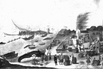
The discovery of this profitable natural resource soon led to geopolitical conflict. The first claims to the no-man's land of Spitsbergen were made by the English and the Danish kings, in order to protect the interests of their whaling companies. Their representatives or supporters planted colours and arms to show everybody that the land had been claimed (Fig. 1). Christian IV claimed it because he was of the opinion that Spitsbergen was part of Greenland, which he considered to be a part of the Danish realm and the English king James I claimed it because he was convinced that the English had been the first to start whaling in the region (Hacquebord Reference Hacquebord1984: 50; Mathisen Reference Mathisen1954).
Danish flags over a whaling station on Amsterdam Island, Spitsbergen. There exists a similar painting of the same whaling station, but with Dutch flags instead (Skokloster Castle Museum, Sweden).

The Dutch whalers initially did not claim the land but did claim free use of Spitsbergen waters and of the whales in those waters. Later they understood that they had to claim the land in order to process the whales. The Dutch whalers asked the States General for men-of-war to protect their fleet and the Dutch interest in whaling. They received this protection and to mark their claim Dutch whalers built houses in the bays used by the English whalers, which the English mostly demolished and then used the materials to build their own facilities in another place. Later the Dutch even built a fortress to protect their main station of Smeerenburg (Hacquebord and others Reference Hacquebord, Steenhuisen and Waterbolk2003).
In this competitive way, whaling began in the bays of Spitsbergen in the second decade of the 17th century. It was a market-driven international activity with the English Muscovy Company and the Dutch Noordse Compagnie as the most important actors. These two companies not only controlled the catch but also managed the whale population. They built temporary whaling stations, mostly close to the locations where the whales were killed.
The Dutch and the English whalers competed for the resources and for good station sites, which resulted in many conflicts. These conflicts led to decreases in the profits of the companies. Therefore, in 1623 the English and Dutch whaling companies agreed to end this useless competition. It worked because the Dutch concentrated their activities in the north and the English stayed in the southern bays of Spitsbergen (Muller Reference Muller1874).
In this way, the Dutch occupied the best hunting ground because the edge of the ice pack was mostly near the northwest coast of Spitsbergen and the bowhead whale was always to be found near the edge of the ice pack. Not the killing but the processing of the whale formed the bottleneck of the industry: flensing and cooking were the weak parts in the process chain. It made the whalers dependent on the land for their cooking activities. Claims on the no-man's land of Spitsbergen were the consequence of this dependency on the land.
Around 1650 the environmental situation changed because ice blocked the bays and shortened the working season on Spitsbergen. The whalers reacted to the new situation by moving the flensing and cooking of the blubber out of the bays and flensed the whales alongside the ship or on an ice floe. The blubber was put into barrels, and then transported to the homelands where it was cooked in newly built tryworks. The stations on land were abandoned, so land occupancy was unnecessary. For the whalers Spitsbergen was no longer important. This lasted until the second half of the 19th century before the resources in the Arctic archipelago once more became interesting for western Europeans. The whaling trade became open to everyone. It was not possible to control the catch, so that the companies were no longer able to function (Hacquebord Reference Hacquebord1999).
Thus, although there were economic factors driving the development of whaling, the industry had geopolitical consequences. Governments laid claim to Spitsbergen in order to protect the business of their subjects and the whaling companies claimed coast lines that were strategically attractive to them as a base for catching whales and processing the blubber. It is also clear that changes in the extent of the Arctic sea ice had an impact on this development. The edge of the ice pack steered the location of the whales and so too the activities of the whalers and thus determined the success of the trade. It resulted in open competition between whalers from different nations. The consequence was an almost total extermination of the Atlantic population of the bowhead (Hacquebord Reference Hacquebord1999: 381).
The Pomor hunting period
From the beginning of the 18th century, Spitsbergen formed the hunting ground of walrus hunters from the northwest of Russia. These hunters, known as Pomors [coastal people in Russian], established an extensive network of base camps and outposts along the coasts of the archipelago. From these stations the Pomors exploited a wide range of animals, including walrus, reindeer, polar fox and seals. The walrus formed the main target of the hunters for its valuable ivory teeth. The hunting activities of the Pomors came to an end in the mid 19th century. Our knowledge of Pomor hunting is still limited, but it is obvious that the driving forces were first and foremost economic.
Why the Pomors started to organise hunting expeditions to Spitsbergen is still an unanswered question. The first Spitsbergen expeditions were probably started by small groups of professional hunters coming from Pomor villages in the north coast of Russia, in search of new hunting grounds (Jasinski Reference Jasinski1993: 69). These hunters only spent the summer season on Spitsbergen, where they stayed in small huts which they built from a combination of driftwood and building materials they brought with them (Jasinski Reference Jasinski1993: 21).
Information from 18th century documents together with archaeological data make clear that in the course of that century larger groups went to Spitsbergen, bringing pre-fabricated houses and also staying for the winter season. This change was most likely the result of the establishment of trade and hunting monopolies issued by the state government in Pomorye which influenced the situation in Spitsbergen (Jasinski Reference Jasinski1993: 69–70). Greater investments made it possible to provide the hunters with sufficient supplies to enable them to stay on Spitsbergen for a whole year or even longer and so to exploit the resources in an optimal way. During the long dark winter months the hunters could not hunt sea mammals but were engaged in the preparation of skins for the production of shoes which could be sold in the home country, in the making of other handiwork and in the hunt for fur animals. The people and organisations involved in these expeditions were in the activity for financial reasons. The hunters did not seem to have been actively involved in making claims to Spitsbergen for Russia. The Russian government did not use the Pomors as an argument in diplomacy until 1871, in response to an attempt by Sweden to claim Spitsbergen as a colony for the Swedish-Norwegian union (Mathisen Reference Mathisen1954: 25; Hultgreen Reference Hultgreen2000: 19). Only the Chichagov expeditions in 1765 and 1766 might indicate a political interest of the Czars in Spitsbergen. These expeditions were probably undertaken to explore the possibilities of colonization of Spitsbergen and to carry out scientific observations (Conway Reference Conway1906: 264–265).
The physical remains of the Pomor hunting activities on Spitsbergen also point in the direction of economic activity without political agendas. At Green Harbour, the LASHIPA project carried out archaeological excavations of an 18th century Russian hunting station, located at Kokerihamna. Initially, whalers established a whaling station here as early as the 17th century. In the 18th and 19th centuries, Pomors, and later Norwegian hunters, re-used the site as a hunting station. The archaeological research has provided insight into the way the Pomors exploited natural resources. It is clear that the station was used as a base camp in the 18th century, a centre for hunting activities within a much larger surrounding area. It consisted of several huts situated on a terrace overlooking a cape and a natural harbour, and on a second terrace above the huts there is a number of graves which are likely to be of Pomor origin. The huts were mainly constructed in log cabin style for which a combination of re-used ship wood and pre-fabricated wood was used. The artifacts found during the excavation consisted of (black) Pomor pottery, some sherds of slipware pottery, some fragments of tobacco pipes, numerous pieces of leather, some textile, metal objects and many animal bones (Aalders and others Reference Aalders, Avango, De Pasqual, De Haas, Hacquebord, Gustafsson, Hartnell and Kruse2009).
The bones and the artefacts point to activities that had clear economic motivations. The many pieces of leather indicate that the Pomors prepared skins and fabricated shoes at the site. The greatest number of the bones came from reindeer, which the Pomors hunted for consumption but also for the furs and skins. Other bones were from the walrus, seal and polar fox.
Similarly to the whalers, the Pomors only used the most economically profitable parts of the animals they killed. The primary target for their hunting activities was the walrus. At Kokerihamna only parts of walrus skulls were found and no bones from other body parts. The skull remains showed traces of heavy cutting. This indicates that the hunters chopped off the heads of the walruses at the killing sites and brought these with them to the base camp where they could take the time to remove the valuable ivory teeth. They did not use the meat of the animals but instead left it behind at the killing sites. Perhaps they also used the blubber but this has left no traces in the archaeological record (Aalders and others Reference Aalders, Avango, De Pasqual, De Haas, Hacquebord, Gustafsson, Hartnell and Kruse2009; Avango and others Reference Avango, Hacquebord, Gustafsson and Hartnell2008).
The settlements the Pomors used grew larger over time and were frequently occupied all year round. The dead were usually buried on a higher terrace behind the base-camp. At many Russian settlements large wooden crosses were erected. These crosses had several functions. Their primary function was theological (Conway Reference Conway1906: 252) but they may also have functioned as navigation beacons, and, quite likely, to make clear the area was occupied. In this respect the crosses could be considered as claiming symbols.
In contrast to the whalers, the Pomors did not have to struggle with competition over resources on Spitsbergen and rarely entered into conflicts concerning the control of resources or areas. When the Pomors started to organise expeditions to Spitsbergen the whalers had already abandoned their land based stations. The situation changed in the 19th century when Norwegian hunters also began organising hunting expeditions to Spitsbergen. These hunters were interested in the same resources as the Pomors and so formed strong competition. The Norwegians had the advantage that they could sail out to Spitsbergen earlier in the season than the Pomors, who had to wait for the White Sea to become ice free. Therefore the Norwegian hunters could occupy the best spots. This increasing competition from Norwegian hunters on Spitsbergen was one of the factors leading to the end of the Pomor hunting period on the archipelago. Another reason is that the groups going to Spitsbergen became too big and the profits were not sufficiently high to make the investments in the expeditions worthwhile. Some documents are known in which merchants are complaining about the unprofitability of the Spitsbergen hunt. Around the beginning of the 19th century a thriving trade between Pomors and Norwegians had developed in northern Norway, the so-called Pomor trade. Merchants who previously had invested in sending out expeditions and ships to Spitsbergen now invested their money into this trade. Sending out ships and men to northern Norway to trade grain for cod was much less risky than sending out expeditions to Spitsbergen and the profits much better (Jasinski Reference Jasinski1993: 20, 59, 70).
The mining period
During the nineteenth century, European scientists began to pay attention to Spitsbergen. A large number of expeditions were sent there to study its flora, fauna, geology and geography. The archipelago seemed to hold answers to important scientific research questions, for instance regarding the ice age hypothesis, about the geological history of the earth and indeed the lack of geographical knowledge about region. At the same time, the research efforts should be seen as a part of colonial science, part of a quest for new territories and natural resources (Liljequist Reference Liljequist1993; Sörlin Reference Sörlin, Sörlin and Bravo2002; Wråkberg 1999, Reference Wråkberg, Zachariassen and Tjelmeland2004).
In the late 19th century, the scientists were accompanied by mineral prospectors and mining companies interested in coal. After the turn of the century a mining industry developed on Spitsbergen, an industry that is still in business today. The history of this industry can be divided into three different phases. During the first phase (starting in 1898), Arctic Ocean skippers from northern Norway started up small prospecting companies which claimed coalfields on Spitsbergen. Their coal mines were very small in scale and only in operation during the summer time. During the second phase actors with more economic resources arrived on the scene and opened up coal mines for year round production. The first ones were British (Advent City, 1905) and American (Longyear City, 1906) and soon coal mining companies from several countries in the western world established large scale mining operations. This coal rush period came to an end during the mid and late 1920s, when most of these mining companies had gone bankrupt and had to close down their mines. Primarily, this was as a result of the deep recession in the early 1920's and falling world market prices for coal after the WW1 price rise had ended (Arlov Reference Arlov2003: 348; Avango Reference Avango2005). During the third phase (late 1920s up to present), there have been only two nations involved in mining, the Soviet Union/Russia and Norway, which have operated several large scale coal mines each, some of which are still in production (Hacquebord and Avango Reference Hacquebord and Avango2009).
The principal driving force behind this coal mining industry was economic. There was a constantly expanding market for coal at the time, especially in the Scandinavian countries that were rapidly industrialising and expanding their railway networks. When the Norwegian skipper Søren Zachariassen and his crew started mining coal at Green Harbour and at Cape Boheman in 1899, they did so because there were good business opportunities; the prices for coal were peaking (Avango Reference Avango2005). Because of the profits Zachariassen made, other Norwegian skippers followed his example, forming mining companies (Reymert Reference Reymert and Jernkontoret2004). Larger companies during the early second phase started their coal mines because of the profits they believed they could make on the coal market in Scandinavia and northern Russia. These northern nations had no coal resources of their own, and therefore depended on imported coal. One such company, studied within one of the sub-projects of LASIHPA, was the US firm The Arctic Coal Co (Hartnell Reference Hartnell2009).
Economic motives were also at play behind the operations of several British mining companies from 1904 and onwards, that are analysed within another of the sub-projects of LASHIPA. In 1910, for instance, the Northern Exploration Company formulated an aim to ‘engage in all kinds of exploration and prospecting, and in particular exploring and prospecting for mines, minerals, precious stones, and oil, and to employ, organize, equip, and dispatch expeditions, experts and other agents’ (Northern Exploration Company 1910). It was a prospecting company, primarily interested in investigating, claiming and then selling its claims to others at a profit. The Scottish Spitsbergen Syndicate operated with similar motives, but also declared an intention to open up mines (Speak Reference Speak1982). The Spitsbergen Coal and Trading Co had more ambitious plans, they opened the first settlement for year-round coal production, Advent City. However, the company closed its mine after only two years of production, when it turned out that it would not make a profit and that the company would not get government support in order to control their rebellious workforce (Martin and others Reference Martin, Avango, Martin, Hacquebord, Oglethorpe, Nisser and Rossnes2005: 33–38). The workers had taken control over Advent City in the spring of 1907, because of dissatisfaction with salaries, living conditions and the leadership style of the local management. Labour conflicts were common at the mining settlements on Spitsbergen, but Advent City was the only case where it led to the closing of a mine (Avango Reference Avango2005: 206–209).
Some of the Spitsbergen coal mines were opened at the end of World War I or just after. The reason, no doubt, was the record high coal prices resulting from the war. Over those years mining companies from the Netherlands, Sweden, the UK, Russia and Norway established coal mines and mining settlements on Spitsbergen. One company which is being researched within the LASHIPA project is the Dutch mining company N.V. Nederlandsche Spitsbergen Compagnie (NESPICO). This company was active on Spitsbergen between 1919 and 1932 and operated the coal mines of Rijpsburg and Barentsburg, the latter being the largest and most technologically advanced coal mine on Spitsbergen in the 1920s. These Dutch entrepreneurs were interested in the Spitsbergen coal solely for commercial reasons. There was neither government involvement nor geopolitical motivation in the founding of this company (De Haas Reference Haas2008). Coal prices in the Netherlands quadrupled between 1914 and 1920 and there was a severe coal shortage, with up to 50% of the coal demand not being met by local production and imports in 1918 (Mous Reference Mous1952; Graaf Reference Graaff1943). In the first post-war years, expectations were that supply and demand would remain in unbalance well into the 1930s. Thus, the coal deposits of Spitsbergen could offer a proper business opportunity. However, from 1922 onwards, the international coal markets recovered more quickly than anyone had anticipated. As a result, NESPICO had difficulties in raising new capital and becoming operational, especially after the already immense investments it had made on Spitsbergen. The subsequent downfall of NESPICO was the result of structural changes in the international coal market, of some over optimism and of failing company policies (Nespico 1921–1950). These problems were less acute for mining companies that were kept in operation for geopolitical reasons (Johannessen Reference Johannessen1996).
In a way similar to the whalers and Pomors, the mining companies only exploited the most profitable resources, in this case the coalfields that required the least initial investment. They established their mines and mining towns at locations where the coal seams were easily accessible in the mountain sides above sea level and where there were reasonable harbour conditions nearby. In addition there had to be a strip of flat land, large enough to host a mining settlement, a transport infrastructure and large scale coal storage (Avango Reference Avango2005: 123–124). The case of the Swedish mining company AB Isfjorden-Belsund is particularly revealing. Initially this company was interested coal from the Carboniferous period and therefore claimed areas where such coals where present. The most promising of those areas was the Bünsow land. However, in the coastal zone of this peninsula, the company estimated the coal seams to be located approximately 200 m underground. Setting up a coal mine there would have meant heavy investment costs in shaft drilling, hoisting machinery and possibly water pumping for drainage. Therefore, the mining company opted for Tertiary coals instead and established their coal mine at Braganza bay, a site with easily accessible coals above sea level and close to a reasonably good harbour site (Högbom 1910, 1911; Mossberg 1911). For the same reasons, no mining company has so far exploited the carbon coalfields under the Bünsow land despite the fact that several mining companies, from Scotland, England and Finland, have been sufficiently interested to claim and investigate the area and to develop plans for coal mining (Avango Reference Avango2005: 342–343).
There were also political factors driving the development of coal mining on Spitsbergen which contributed to the setting up of several mining operations in the first decades of the 20th century. After the dissolution of the Swedish-Norwegian union in 1905, the Norwegian government wanted to manifest the vigour of the young nation by expanding its influence in the north, including the no-man's land of Spitsbergen. In 1909, it openly suggested that Spitsbergen should be governed by Norway (Berg Reference Berg1995, Reference Berg, Zachariassen and Tjelmeland2004). The suggestion triggered strong reactions in Sweden, Russia and in the United States, who for different reasons wanted Spitsbergen to stay a no-man's land. To the Swedish government it was a matter concerning which nation should take initiatives in foreign policy matters of common interest for the Scandinavian countries. Such initiatives should be taken in Stockholm, not in Christiania (Oslo), the capital of the newly independent Norway. Thus it was a matter of national prestige to the Swedish foreign ministry and part of a strategy in which the Spitsbergen issue was a means rather than an end (Avango Reference Avango2005). National prestige was also important to the Russian government, who claimed historical rights to Spitsbergen based on the Pomors, who had, they claimed, discovered the archipelago. The Russians were also interested in the coal, which could be used in northern Russia (Holtsmark Reference Holtsmark1993; Laijus Reference Laijus and Jernkontoret2004). The US government standpoint was economically motivated. Norwegian sovereignty could interfere with the business interests of the American firm The Arctic Coal Co and its mine in Longyear city. The disagreements resulted in a series of international conferences on the future legal status of Spitsbergen which took place in the Norwegian capital Christiania in 1910, 1912 and 1914 and again in Paris in 1919–1920 (Mathisen Reference Mathisen1954; Sing Reference Singh1980; Berg Reference Berg1995; Avango Reference Avango2005).
The conflict was also played out on Spitsbergen itself and some of the mining companies were involved in it. The governments in Norway, Russia and Sweden supported their mining companies financially as well as politically in order to establish effective occupation on Spitsbergen and thereby legitimize claims of sovereignty or political influence. These policies resulted in the establishment of several coal mines. The Russian government initiated an expedition that laid claim to coalfields on the south side of the Ice fiord and supported the formation of the ‘Grumant, A. G. Agafelloff & Co’ to mine it. The company established a mining camp marking out their claim to the coal, a claim that was also meant to strengthen the influence of Russia on the Spitsbergen issue. In a similar way, the Swedish foreign ministry initiated an expedition that claimed coalfields for Sweden in 1910. As a consequence, a Swedish mining company was formed which established Sveagruvan [Svea mine] in 1917 (Laijus Reference Laijus and Jernkontoret2004; Avango Reference Avango2005).
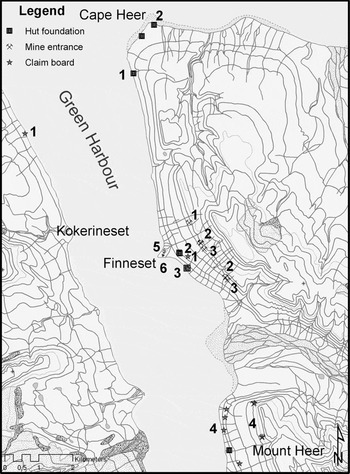
At Green Harbour (Fig. 2), several Norwegian mining companies were involved in these political activities. The Arctic Coal Co (USA) had controlled the eastern side of this bay since 1905, but from 1908 a number of Norwegian mining companies challenged its claim by establishing mining operations there. The most important ones were the Green Harbour Coal Co. and the Norske Kulkompani Ltd. Green Harbour. The owners of these companies were first and foremost interested in making a profit from their coal mines. At the same time however, they readily contributed to a strategy by the Norwegian government to strengthen the Norwegian position on Spitsbergen by claiming resources and territories there. They did so by performing rituals of possession and by erecting symbols of occupation, which they reported back to the Norwegian ministry of foreign affairs. Thereby they legitimised their claims and at the same time provided tools that Norwegian diplomats could use in negotiations. By doing so, they also made it virtually impossible for the Arctic Coal Co to develop a profitable mining operation at Green Harbour or to sell the coalfield to somebody else. Their actions contributed to the decision by the Arctic Coal Co to sell their coalfields to their Norwegian competitors in 1916. As a result, Norwegian organisations controlled considerable parts of Spitsbergen at the time when the negotiations on the Spitsbergen treaty started in Paris in 1919–1920, which gave Norway a strong position from which to push their demands (Avango forthcoming).
Remains of coal mines, buildings, whaling and radio stations, and claim boards, documented by the LASHIPA project during the IPY at Green Harbour, Spitsbergen. The structures were built by competing American and Norwegian operations in the first decade of the 20th century. The structures had both practical and symbolical functions, facilitating work and at the same time legitimising claims for control of natural resources and for political influence. The structures were built by the following organisations, 1) Kulkompagniet Isefjord-Spitsbergen, 2) The Arctic Coal Co., 3) The Green Harbour Coal Co., 4) Det Norske Kulkompani Ltd. Green Harbour, 5) The Norwegian state (radio station), and 6) A/S Spitsbergen (whaling station). Map: Dag Avango.

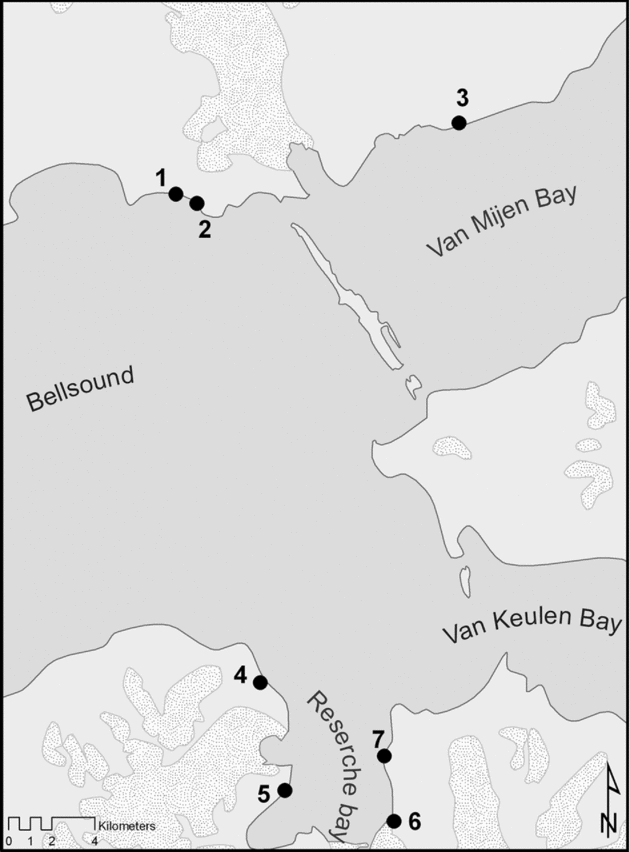
Some mining companies acted to obtain sovereignty over Spitsbergen for their home country, without having the slightest political support from their own government. That was the case with two of the British mining companies, the Northern Exploration Co and the Scottish Spitsbergen Syndicate. Prominent representatives of those companies argued that Spitsbergen should be included in the British Empire. In order to strengthen their case, they argued that almost all of the coalfields on Spitsbergen were controlled by British mining companies (Bruce undated). The LASHIPA field work however, has made clear that these companies used some of their prospecting camps to support that argumentation by widening the extent of the British claims on Spitsbergen. By placing buildings and other constructions at locations with favorable harbour conditions, also in areas with poor or no natural resources at all, they were able to symbolically claim control over vast extents of land (Fig. 3) (Avango and others Reference Avango, Hacquebord, Gustafsson and Hartnell2008).
Sites with remains of mining and exploration camps built by the British firm The Northern Exploration Company, mapped by the LASHIPA project in August 2006. In the early 20th century, the camps filled practical purposes as well as symbolic ones. The company was able to use them to support their argument that Spitsbergen should belong to Great Britain. 1) Camp Bell, 2) Camp Milar, 3) Camp Morton, 4) Camp Calypso, 5) Camp Smith, 6) Iron range camp, and 7) Edge point camp. Map: Dag Avango.

Some companies were involved in the politics of Spitsbergen only to protect their investments. Contrary to what has been suggested in previous research, this was the case with NESPICO; there was no Dutch political motive or Government involvement driving this company. However, in order to secure its rights, NESPICO called in the help of the Dutch government in the diplomatic process concerning the legal status of Spitsbergen (De Haas Reference Haas2008). Similar efforts were made by Swedish and British mining companies, which contributed to the limitations placed on Norwegian sovereignty in the Spitsbergen Treaty. The treaty stipulated that citizens of all signatory countries would keep equal economic rights. Furthermore, Norwegian rights concerning taxation remained restricted (Mathisen Reference Mathisen1954; Østreng Reference Østreng1971; Berg Reference Berg1995; Avango Reference Avango2005).
During the third phase of coal mining on Spitsbergen, there has been a mixture of economic and political motives behind the continued operation of the industry. In the late 1920s Soviet companies started to acquire coalfields and coal mining towns, the Grumant City, the Pyramiden coalfield, Barentsburg and the other NESPICO treaty properties at Green Harbour and Cape Boheman. In response to this Soviet expansion, the Norwegian government and the mining company Store Norske bought several coalfields and coal mines, for example Sveagruvan and The Northern Exploration Co coalfields (Avango Reference Avango2005: 341–355). Therefore, from 1934 and onwards, with a brief interruption from 1941–1946 because of World War II, there were mining companies from only two nations operating on Spitsbergen: Russia and Norway. They continued their activities because they still had political motives to do so. It is true that both nations made economic use of the coal, in Norway for heating, railways, steam energy and from the 1970s also for coke production. The Soviet Union included the Spitsbergen coal in its five year plans for the Murmansk region economy. However, the Norwegian coal mines operated with an economic loss and were maintained in operation for political reasons. Norway felt the need to have effective occupation in order to maintain the legitimacy of the Spitsbergen Treaty. Russia on the other hand wanted to keep a foothold in a region that was strategically located in relation to the military port of Murmansk (Arlov and Hoel Reference Arlov, Hoel, Jølle and Drivenes2004).
Thus, there were several factors driving the development of the Spitsbergen mining industry. Most mining companies were started for economic reasons, there was a market for coal and there were profits to be made. Many of the mining companies subsequently got involved in the struggle for political influence over Spitsbergen by trying either to achieve sovereignty for their own governments or to limit the influence of others in order to protect their investments and business interests. Some mining operations however were actually started or later maintained with the primary purpose of reaching political goals, in particular from the 1930s onwards.
Modern whaling in Spitsbergen geopolitics
The final branch of natural resource exploitation that will be considered here is the modern whaling industry. This industry established itself in Spitsbergen in 1904. Eight companies from the Finnmark region in northern Norway conducted whale hunting in the waters around Spitsbergen and Bear Island, some operating from whaling stations and some from floating factories. The industry was short lived however; the last two companies ceased operating in Spitsbergen after the 1912–1913 seasons.
The modern whaling industry evolved in northern Norway in the second half of the 19th century. It was a profitable industry, supplying an expanding market for whale oil products. However, the whaling industry came increasingly into conflict with the local fishing industry, which blamed the whaling companies for reduced catches. In 1904, the Norwegian government responded to the situation by totally banning whaling along the Norwegian coast. This was the primary reason why the whaling companies operating in Finnmark moved their operations to the waters of Spitsbergen. In 1905, seven enterprises operated in the waters of Spitsbergen and one at Bear Island. Most of them operated from floating factories, but two of the companies established land based whaling stations, one at Finneset in Green Harbour, Spitsbergen and the other one on Bear Island (Risting Reference Risting1922; Johnsen and Tønnessen Reference Johnsen and Tønnessen1959).
From these events it seems quite clear that the primary reason for the whaling companies to establish their operations on Spitsbergen was economic. After the Norwegian government had banned them from Norway, they wanted to continue making profits somewhere else. Spitsbergen was relatively nearby, there was a whale population present and the archipelago was a no-man's land. Thus, the establishing of whaling stations there was not motivated by the contemporary attempts by the Norwegian government to claim sovereignty over Spitsbergen. In fact, when the Norwegian ministry of foreign affairs approached the whaling companies in 1907 to seek their support for the idea of a Norwegian Spitsbergen, the companies were reluctant to cooperate. From their point of view, their businesses would profit most from keeping Spitsbergen and Bear Island as no-man's land. After all, Norwegian sovereignty could mean an extension of the 1904 ban to include also Spitsbergen and Bear Island (Sandefjord Whaling Museum 1909; Berg Reference Berg1995; Gustafsson Reference Gustafsson2008).
The economic character of the whaling activities is further underlined by the fact that most of the whaling companies terminated their operations in Spitsbergen and on Bear Island when the activities failed to deliver the expected economic returns. This was partly because of the long distances between the whaling stations, the hunting grounds and the market which increased the costs, but also because sea ice and fog often obstructed the whaling operations. As a result some of the companies established themselves in the new Antarctic hunting grounds off South Georgia and the South Shetland Islands, where the whale stocks were abundant (Johnsen and Tønnessen Reference Johnsen and Tønnessen1959).
The whaling companies’ lack of enthusiasm for a Norwegian Spitsbergen, however, did not stop the Norwegian foreign ministry from using the whaling companies in their arguments. One of these was that Norway had the greatest economic interests in the archipelago. Seen from this angle, the activities of the whaling companies probably proved to be useful for Norwegian diplomacy. The whaling companies did not only build stations, they also claimed land in order to secure sheltered harbours and access to freshwater. In a fashion similar to the mining companies, they did so by performing rituals of possession and by erecting various claim markers, like signboards or huts. Thereby, whether the whalers liked it or not, the foreign ministry could use their claims and stations to strengthen their argument for a Spitsbergen governed by Norway (Gustafsson Reference Gustafsson2008).
There are also some indications suggesting that the whaling industry, over time, became more actively involved in the attempts by the Norwegian government to take control over Spitsbergen. Only two whaling companies remained on Spitsbergen in 1909 and despite the above mentioned unsatisfactory economic returns, these companies increased their territorial claims, invested in new buildings and technologies and bought shares in Norwegian coalmining companies. At Green Harbour, these activities effectively hindered an American mining company there from gaining access to a harbour and to freshwater supplies, thereby effectively obstructing their operations. In addition, the whaling companies assisted Norwegian scientific expeditions, De Norske Statsunderstøttede Ekspedisjonerna, which had been initiated by the Norwegian foreign ministry as a part of a covert strategy aimed at gaining sovereignty over the archipelago. Moreover, these whaling companies maintained their territorial claims in the archipelago up until the Spitsbergen Treaty was signed in 1920 (Bogen Reference Bogen1937: 154–156; Gustafsson Reference Gustafsson2008).
Thus, it is quite clear that the whaling industry on Spitsbergen was first and foremost motivated by the profits that could be made on the traditional markets for whale oil. In other words, there were economic factors driving this industry. Moreover it is clear that initially the companies did not support the idea of Norwegian sovereignty on Spitsbergen. However, the whaling companies and their activities were used in Norwegian diplomacy, as proof of Norwegian economic interests. There are also indications that some of the whaling companies, over time, became supporters of the Norwegian quest for Spitsbergen.
Conclusions
The exploitation of natural resources in Spitsbergen has, in most cases, been first and foremost market driven. The activities were undertaken to supply the markets for whale oil, furs, ivory and coal. In most cases, only the most economically important products were exploited and when the exploitation was not profitable anymore, activities were halted.
But it would be wrong to conclude that economic issues were alone important. It is equally clear that in the past 400 years, large scale exploitation of natural resources has been related to geopolitical conflict. The relations between the political strategies of national governments and those of the resource exploiters have been different in different cases. As pointed out by researchers on the diplomatic history of Spitsbergen like Mathisen (Reference Mathisen1954) and Østreng (Reference Østreng1971), we have found several instances in which governments took political action in order to protect the investments and business interests of companies from their nations. In the 17th century they used men-of-war, letters of support and charters to protect the whaling companies. In the case of Britain and Denmark, they even claimed sovereignty over Spitsbergen for the purpose. In the 20th century, governments used diplomacy to help mining companies from their nations, as in the case of NESPICO. These were political actions taken on behalf of economic interests.
However, we have also shown that there were more significant driving factors. In line with historians like Berg (Reference Berg1995, Reference Berg, Zachariassen and Tjelmeland2004) and Johannissen (1996), we have identified several cases where governments supported and even initiated industrial projects in order to pursue political strategies motivated by national prestige or foreign policy issues with a wider scope than the natural resources of Spitsbergen. This was the case with some of the mining projects in the early 20th century, for example the Swedish (AB Isfjorden-Belsund), Norwegian (Norske Kulkompani Ltd. Green Harbour) and the Russian (Grumant, A. G. Agafelloff & Co). For political reasons, the Norwegian government supported their whaling companies in Spitsbergen in the same time period, without even receiving the active support of these companies for the idea of a Norwegian Spitsbergen. These were political actions taken in order to further political interests. Finally, there were also instances where resource exploiters lobbied for sovereignty, without getting any support from their national governments at all, as in the case of the British companies The Northern Exploration Co and The Scottish Spitsbergen Syndicate.
In all of these cases, the competing actors used different forms of ceremonies and symbols in order to strengthen their positions. The 17th century whalers used poles, national colours, arms and huts to mark out their claims. The 20th century mining and whaling companies raised signboards and huts. These objects functioned as material actors with the ability to guard claims of possession of resources and territories in the hostile and distant lands of the High Arctic.
Thus, the current interaction between oil and gas interests and the governments of the Arctic coastal states is nothing new in the history of the high Arctic and neither is the practice of flag waving. Today the legal context is different, and there are more organisations involved in the governance of the region. Nevertheless, the results of the LASHIPA project indicate that we can expect a great deal of complexity in the interaction between governments and resource exploiters in the future. Not all activities will be what they seem to be and not all actors will actually do what they seem to be doing and should therefore be approached with care in future research. The LASHIPA project intends to build on these conclusions, as we move on and broaden our research to circumpolar and bi-polar comparative analyses of the interaction between large scale natural resource exploitation and polar politics.