

INTRODUCTION
Political geography has played a prominent role in discussions concerning the development of settlement patterns, and their underlying societal structures, in Cyprus during the Middle to Late Bronze Age (c.1725–1200 bc). This focus is primarily due to the association of all or part of the island with the kingdom of Alashiya, as known from eastern Mediterranean court correspondence of the second millennium bc. The most compelling evidence in favour of this link is Alashiya's role as a prolific exporter of copper, which matches the Cypriot archaeological record for extensive metallurgical industry. Attempts at correlating archaeological and textual data have to date largely focused on the identification of a palatial capital (e.g. Muhly Reference Muhly and Peltenburg1989, 299–303 for Enkomi-Ayios Iakovos Footnote 1 ), and to a lesser extent island-wide settlement systems (e.g. Knapp Reference Knapp1997, 64–72).
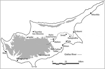
While the association between Cyprus and Alashiya has not been unequivocally accepted (cf. Merrillees Reference Merrillees1987), this study does not seek to revisit the central question of identity, which has received comprehensive and thoughtful treatment elsewhere (e.g. Knapp Reference Knapp1996, 3–11; Goren et al. Reference Goren, Bunimovitz, Finkelstein and Na'aman2003). The more modest aim is to examine the implications of this equation as it pertains to settlement patterns in south-east Cyprus, with particular reference to the environmental context in which these developed (Fig. 1). Using this approach it is intended to highlight the natural resources and hinterlands upon which communities depended for their livelihood, as well as providing a novel analytical context within which to critically re-evaluate existing culture-history narratives. The paper begins by reviewing the development of settlement landscapes along the banks of the Gialias river, and clustered around the natural embayments of Larnaca Bay.Footnote 2 Geopolitical characteristics of Alashiya will then be considered in light of this evidence, with reference to possible economic mechanisms underlying their development in south-east Cyprus.
Late Bronze Age settlement on Cyprus with principal sites in the south-east of the island.

THE GIALIAS RIVER: INDUSTRY AND TRANSPORTATION NETWORKS
By far the longest stretch of river in Cyprus that was potentially navigable during antiquity is the Gialias at c.60 km between the eastern coastal ports of Kalopsidha-Enkomi-Salamis and inland settlements in the region of Ayios Sozomenos-Idalion. The past geomorphology of this semi-arid watershed has recently been examined in detail by Devillers (Reference Devillers2008). While the Gialias and its tributary the Alykos are now reduced to ephemeral streams, largely due to modern upstream damming, in the second millennium bc these rivers would have constituted a substantial inland waterway outside of the dry summer months. The clear orientation of occupation along the banks of the Gialias reflects its important role in shaping the settlement landscape of south-east Cyprus.
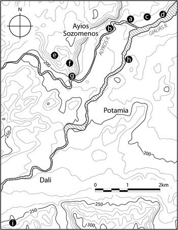
At the beginning of the Late Bronze Age in Middle Cypriot III to Late Cypriot II, the upper Gialias valley formed one of the most intensive landscapes of settlement on the island (Fig. 2). Based upon survey results and limited excavation, occupation appears to have been split between two clusters at either end of the Ayios Sozomenos escarpment, further divided between adjacent upland and lowland zones. In the north, surface material at Ambellia covers an area of approximately 3 ha (Catling Reference Catling1963, MC.21 + LC.37; 1982, 231–2). Immediately to the south at Kakoskalin a trial sounding revealed further traces of Late Cypriot occupation beneath c.4 m of sediment (Devillers, Gaber and Lecuyer Reference Devillers, Gaber and Lecuyer2004). Although this extensive overburden, and the resulting lack of surface artefacts, precludes a reliable determination of settlement extent, its antiquity can be inferred from Middle Cypriot surface material in the neighbouring plot of Galatere (Catling Reference Catling1963, MC.28).
Late Bronze Age sites in the upper Gialias valley. (a) Ayios Sozomenos-Ambellia; (b) Ayios Sozomenos-Kakoskalin/Galatere; (c) Ayios Sozomenos-Kamina; (d) Ayios Sozomenos-Kafkalla tis Drakontias; (e) Dhali-Kafkallia; (f) Ayios Sozomenos-Nikolidhes; (g) Ayios Sozomenos-Glyka Vrysis; (h) Potamia-Ambelin; (i) Idalion-Ambelleri. All elevations metres above sea level.

At the southern end of the Ayios Sozomenos escarpment, two settlement sites at Nikolidhes (Fortin Reference Fortin1981, 45–9) and Dhali-Kafkallia (Overbeck and Swiny Reference Overbeck and Swiny1972, 25–8) are located on upland areas of the plateau. Below on the western bank of the Alykos, a large structure of Middle Cypriot III–Late Cypriot I/II date was excavated by Gjerstad (Reference Gjerstad1926, 37–47) at Glyka Vrysis. All three sites have been characterised as small bounded settlements that incorporated a defensive function into their design. The latter architectural feature has led to their collective interpretation as forts or keeps (Fortin Reference Fortin1983).
This combined landscape of settlement was accompanied by a series of extramural Middle Cypriot III–Late Cypriot I/II cemeteries in the north at Ambellia (Catling Reference Catling1963, MC.22 + 23/LC.38 + 39), and in the south at Kafkallia (Overbeck and Swiny Reference Overbeck and Swiny1972, 7–24) and Muttaes (Catling Reference Catling1963, MC.31 + LC.44). Ongoing use of the Kafkallia cemetery from Middle Cypriot III through to Late Cypriot II, despite the late Middle Cypriot III abandonment of the adjacent settlement it was presumably first associated with, suggests a strong tradition of continuity in the lineage and landscape orientation of the region's inhabitants (Overbeck and Swiny Reference Overbeck and Swiny1972, 23).
The lack of architectural features or habitation deposits within the substantial stone perimeter walls of the now heavily eroded Nikolidhes structure indicates it may have been used solely as an enclosure. In contrast, Middle Cypriot III Kafkallia and Middle Cypriot III–Late Cypriot I/II Glyka Vrysis both appear to have been substantial compounds which, on the basis of their known architectural arrangements, served a variety of functions in addition to defence. Kafkallia arguably bears conceptual comparison with, and pioneered many of the architectural traits of, later Late Cypriot IIC ‘fortified’ communities in south-east Cyprus including Idalion-Ambelleri, Sinda-Siri Dash and Pyla-Kokkinokremos.
Citing the prevalence of pithos sherds at Glyka Vrysis as evidence for bulk commodity storage, it has conversely been argued by Rowe (Reference Rowe1995, 70–3) that this site along with a further three to the north represented by surface scatters at Ambellia (Catling Reference Catling1963, LC.37), Kamini (Catling Reference Catling1963, LC.47), and Kafkalla tis Drakontias (Catling Reference Catling1963, LC.46) are more accurately interpreted as warehouses. The apparent increase in the number of these facilities by Late Cypriot I–II (only Glyka Vrysis and Ambellia display firm evidence for an earlier Middle Cypriot III foundation) accords well with more general evidence for an upsurge in long-distance exchange.
Given the need to defend these newly centralised accumulations of wealth, the exclusive interpretation of sites including Glyka Vrysis as either defensive or warehouse facilities is arguably unnecessary. As noted by Peltenburg (Reference Peltenburg2008, 145), the construction of fortifications in Middle Cypriot III–Late Cypriot I represents ‘the first overt signs of communal enterprise on major building projects that visibly transformed perceptions of the landscape of Bronze Age Cyprus’. In combination with the centres for bulk commodity storage and management they were designed to defend, it is further proposed that these structures constitute the first clear architectural evidence of supra-regional political organisation in Cyprus.
By Late Cypriot IIC, settlement within the upper Gialias valley became concentrated at Idalion-Ambelleri (Gjerstad et al. Reference Gjerstad, Lindros, Sjöqvist and Westholm1935; Catling Reference Catling1982, 231), reflecting a wider trend towards synoecism and urbanisation in south-east Cyprus. The site's close proximity to the copper (e.g. Mathiati orebody) and woodland resources of the north-eastern Troodos foothills, and its position towards the southern maximum of the Gialias' navigable extent, combine to make it a likely candidate for the region's main redistribution centre at this time. Although Geometric period occupation immediately subsequent to the main Late Cypriot IIIA phase of settlement is presently restricted to non-architectural habitation deposits, the site's current chief excavator suggests that ‘it is not unwarranted to assume some continuity of life at Idalion in the transitional period from the Late Bronze Age to the Early Iron Age’ (Hadjicosti Reference Hadjicosti, Iacovou and Michaelides1999, 38).
Directly preceding and initially concurrent occupation in the vicinity of Ayios Sozomenos is also suggested by the presence of White Painted Wheelmade III and Base-ring II wares at Ambellia. The possibility that other riverside storage facilities, including Potamia-Ambelin (Catling Reference Catling1963, LC.216), remained in use cannot be ruled out. Webb and Frankel (Reference Webb and Frankel1994, 20) have proposed that the thirteenth century bc site of Analiondas-Palioklichia, located c.12 km south-west of Glyka Vrysis along the Alykos valley, was an intermediate agricultural support village for mining communities under the control of an Ayios Sozomenos-based polity.
Travelling east, a strategic concern for control of territory on the banks of the Gialias river is visible in the foundation and subsequent fortification of the Late Cypriot IIC–IIIA settlement at Sinda-Siri Dash. A model boat fragment found in a Late Cypriot IIIA tomb potentially reflects the site's role as a river port (Furumark and Adelman Reference Furumark and Adelman2003, 119). The site was also a junction for several overland routes, with its location making it an ideal crossing point over the Gialias river for those travelling north en route towards Enkomi (Furumark and Adelman Reference Furumark and Adelman2003, 66). Terracotta models of equines with panniers attest to the existence of overland caravans during the Bronze Age (e.g. Morris Reference Morris1985, 204, 210–11).
At the eastern end of the Alykos-Gialias-Pedieos river system, ports at Kalopsidha and Enkomi provided an interface between inland waterways, overland transportation, and wider Levantine networks of maritime exchange. Siltation of the Gialias-Pedieos Delta can probably be held responsible for the decline of Kalopsidha, and concurrent rise of Enkomi, during Late Cypriot I–II (Devillers Reference Devillers2008, 141–68). While Kalopsidha is presently located c.13 km inland, it is positioned a mere 3.5 km from a now-defunct river channel, supporting the hypothesis that the site had direct access to the coast through the surrounding lagoon in the mid-second millennium bc. This would help to explain the otherwise conspicuously prominent role the community appears to have played in international exchange with the Levant and Egypt during this period (Maguire Reference Maguire2009). An accompanying landscape change, broadly contemporary with the loss of Kalopsidha's access to the coast, was the disappearance of a small (c.150 ha) island c.6 km to the north-east of the site through its gradual incorporation into the advancing Mesaoria plain (Devillers Reference Devillers2008, 154–6).
The subsequent abandonment of Enkomi in the eleventh century bc, this time in favour of Salamis, implies that degradation of the Gialias waterway was a continuing problem during the intervening period (Lagarce Reference Lagarce and Yon1993, 91). Diachronic progression of settlement in the Gialias Delta can be viewed as a comparable longue durée process of synoecism to that documented within the locality of Ayios Sozomenos-Idalion (see also Cadogan Reference Cadogan, Laffineur and Greco2005, 315). The proximity of the Middle Bronze Age cemetery at Styllos-Trachonas (Catling Reference Catling1963, MC.157) to Enkomi may also reflect this same phenomenon.
At Enkomi large quantities of slag derived from copper smelting demonstrate that ore was transported from inland mining areas to the coast for refinement during the fourteenth century bc (Dikaios Reference Dikaios1969, 61, 11). In earlier periods there is evidence for transportation of processed metals for refinement and casting (Kassianidou Reference Kassianidou, Kassianidou and Papasavva2012, 100–4). In addition to lumber for construction and export, metallurgical industry also required wood for charcoal production.Footnote 3 Moving timber in particular by water wherever possible would seem more practical than dragging large pines and cedars overland further than was absolutely necessary. A comparable operation where logs were shipped using riverboats, and/or floated downstream using a tether, is depicted in eighth century bc wall relief sculptures from the palace of Khorsabad in Assyria (Albenda Reference Albenda1983; Linder Reference Linder1986, 278–9). Three Late Cypriot I–II terracotta boat models highlighted by Wachsmann (Reference Wachsmann1998, 64) potentially represent river craft, based upon their common arrangement of a single steering oar resting upon a stanchion, which bears close resemblance to contemporary Egyptian depictions of sailing along the Nile. Another model of Middle Cypriot III date suggests that coracles were also used in Cyprus for more local navigation (Wachsmann Reference Wachsmann1998, 62–3).
The still-substantial incised channels of the Gialias and Alykos rivers in the upper Gialias valley have been examined in detail by Devillers (Reference Devillers2008, 77–139). While it is difficult to estimate seasonal changes in the flow-rate of the Gialias river based on its modern hydrology, the water table in wells presently in use around Dhali can drop as much as 9 m below the surface during the dry summer months (Koucky and Bullard Reference Koucky, Bullard, Stager, Walker and Wright1974, 11). This suggests that waterborne transportation may not have been practical on a perennial basis during the Late Bronze Age. Climatic conditions would also have played a practical role in determining the time of year when timbers were retrieved. Ethnographic and ancient written accounts attest the practice of leaving logs on the forest floor for an extended period of months, in order for the outer rings to be eaten away by termites, leaving the stronger, dense, sap-infused core.Footnote 4 These various considerations favour spring and autumn seasons for more intensive woodland industry.
Our present knowledge of settlement along the Gialias watershed at the beginning of the Late Bronze Age does not yet permit a clear assessment of primacy as regards inland or coastal agency in the exploitation and transportation of copper and forestry resources. Absence of definitive material indicators for state-like characteristics at either Kalopsidha or Enkomi before c.1450 bc renders conclusions regarding the pre-eminence of these communities inherently speculative (Crewe Reference Crewe, Bolger and Maguire2010; Reference Crewe2007; cf. Knapp Reference Knapp2008, 151). Any presumption of coastal agency must also be tempered by the initial occurrence of monumental architecture, in the form of fortifications, inland within the upper Gialias valley (cf. Peltenburg Reference Peltenburg, Karageorghis and Michaelides1996, 30–5; Fortin Reference Fortin and Laffineur1989). In more general terms it can be inferred that inland and coastal settlement would have developed in tandem, as conjoined nodes within an evolving socio-economic system, framed and profoundly influenced by the landscape of the Gialias river and its tributaries.
LARNACA BAY: URBANISM AND MARITIME CONNECTIONS
The second half of the Late Bronze Age saw the development of three major clusters of urban settlement along the south-east coast of Cyprus, located around natural embayments in the Larnaca lowlands and Pyla littoral. These all show evidence for significant maritime links with the Levant and wider eastern Mediterranean. While it should be noted that our understanding of preceding occupation in Larnaca Bay is largely inferred from mortuary contexts, current evidence suggests that the region did not reach a comparable level of social complexity to Enkomi and its environs before Late Cypriot IIC.
At Kition, a series of natural embayments provided an ideal context for the development of urban maritime settlement during the Late Bronze Age and beyond (Morhange et al. Reference Morhange, Goiran, Bourcier, Carbonel, Le Campion, Rouchy and Yon2000, 221, 227). Three main areas of intensive occupation have been recorded at Kition-Kathari and Kition-Chrysopolitissa (Karageorghis and Demas Reference Karageorghis and Demas1985), together with Kition-Bamboula (Yon and Caubet Reference Yon and Caubet1987). Immediately to the south at Hala Sultan Tekke (Åström Reference Åström1986; Fischer Reference Fischer2011), the Late Cypriot I–III site of Dromolaxia-Vyzakia was situated next to the present-day Aliki Salt Lake basin, which, prior to siltation of channels connecting it with the open sea, would have formed the largest sheltered harbour in Cyprus (Gifford Reference Gifford1978). These urban centres were again accompanied by a more dispersed hinterland of preceding Late Cypriot I–II rural occupation at sites including Dromolaxia-Trypes (Åström Reference Åström1977), and Larnaca-Laxia tou Riou (Myres Reference Myres1897, 147–52).
For Hala Sultan Tekke the demise of its harbour was probably the underlying cause of that settlement's decline and abandonment during Late Cypriot IIIA. Faced with the impending loss of their trading infrastructure, this outward-looking maritime community would have been forced to adapt and relocate. The immediate proximity and familiarity of Kition, combined with the subsequent development of port facilities at Kathari and Bamboula, suggest that this was most likely to surroundings nearby. To those involved such a move would have represented an economically driven necessity, and a relatively favourable option when faced with the alternative of relocating further afield. A comparable although more protracted movement of population between multiple sites, based upon changing requirements and natural provisions of anchorage and security, is visible in the extended maritime landscape of Tyre (Marriner, Morhange and Carayon Reference Marriner, Morhange and Carayon2008, 1305–7).
The development of Hala Sultan Tekke and Kition from their rural origins to their rise as urban centres has generally been evaluated separately, on a site-by-site basis. Prior to 1959 and the excavation of stratified Late Cypriot IIC–IIIA material at Chrysopolitissa, the predominant characterisation of Kition was that of an Early Iron Age Phoenician foundation (Karageorghis and Demas Reference Karageorghis and Demas1985, 2). The alternative premise, that the two should be viewed together as part of an evolving landscape of settlement, received some early acknowledgement, if not widespread attention, with both Myres (Reference Myres1946, 72) and Furumark (Reference Furumark1950, 267–8) regarding the Late Bronze Age remains on the southern shore of the Larnaca Salt Lake as the forerunner of the Iron Age capital. More recently, the apparently illogical proximity of Hala Sultan Tekke and Kition, which would presumably have placed their residents in overlapping resource catchment areas, has led Keswani (Reference Keswani1996, 228–9) to postulate that they were independent centres or ‘peers’.
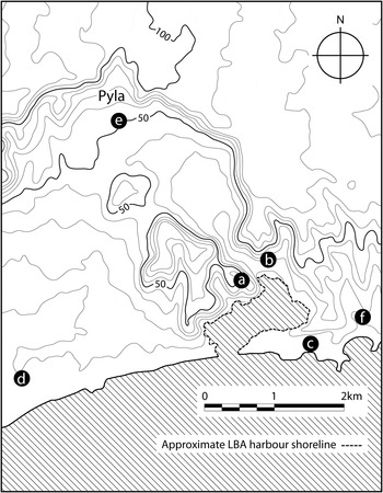
The Late Cypriot IIC community at Pyla-Kokkinokremos was situated on a high plateau rising sharply from the surrounding lowlands with commanding views over Larnaca Bay. This imposing aspect has given rise to the site's characterisation as a ‘naturally defended’ settlement (Dikaios Reference Dikaios1971, 896). Late Bronze Age occupation at Pyla was also defined by a now defunct but once extensive natural harbour (Noller in Caraher et al. Reference Caraher, Moore, Noller and Pettegrew2005, 246–8), which would have rivalled the Larnaca Salt Lake as a sheltered anchorage for ships sailing along the south-east coast (Fig. 3).
Late Bronze Age sites in the Pyla littoral. (a) Pyla-Kokkinokremos; (b) Pyla-Steno; (c) Pyla-Koukoufouthkia; (d) Pyla-Verghi; (e) Pyla-Stavros; (f) Dhekelia-Louma. Approximate harbour shoreline based upon boundary of marine silt deposits. All elevations metres above sea level.

When compared with contemporary urban centres, occupation at Kokkinokremos during Late Cypriot IIC was relatively brief, and is represented by a single major architectural phase. Earlier settlement in the wider Pyla littoral arguably foreshadows the later community at Kokkinokremos, however, in terms of landscape orientation. This is indicated by Late Cypriot IIA–B architecture in the immediate vicinity of the harbour at Steno (Megaw Reference Megaw1956, 25), together with strategic communication routes along the coast around Verghi (Dikaios Reference Dikaios1971, 913–25), and through the pass directly north of Stavros (Ohnefalsch-Richter Reference Ohnefalsch-Richter1899, 337–8; see also Masson Reference Masson1966, 1). The latter would potentially have provided access to the copper resources of Troulli a mere 10 km away. Although there is no firm archaeological evidence for copper mining in this area during the Late Cypriot period (Catling Reference Catling1964, 21–2), earlier workings would probably have been obscured by later Roman mining activity (Stos-Gale and Gale Reference Stos-Gale, Gale, Knapp and Cherry1994, 92).
While all the tombs on the surrounding coastal plain at Pyla were already established c.250–150 years prior to the foundation of Kokkinokremos c.1250 bc, at least one at Steno remained in use concurrently with its occupation (Åström and Åström Reference Åström and Åström1972, 828). This suggests a strong tradition of continuity in burial practice, despite the undoubted social upheaval that would have accompanied the rapid shift from a predominantly rural to urban pattern of settlement. It can be speculated that the arrangement of tombs to the east of the harbour at Pyla-Steno and Pyla-Koukoufouthkia (Megaw Reference Megaw1956, 25), Dhekelia-Louma (Karageorghis Reference Karageorghis1982, 690–1) and Dhekelia-Moutti tou Dhragou (Karageorghis Reference Karageorghis1977, 725) reflects the ‘social distance’ between the numerous Late Cypriot I–II communities of the Pyla littoral, who could have continued to differentiate themselves along lines of lineage even after the bulk of the region's population had been settled together for a generation or more at Kokkinokremos (Keswani Reference Keswani2004, 154–5).
The Late Cypriot IIC settlement at Kokkinokremos was encompassed, at least in part, by a boundary wall that followed the natural perimeter of the plateau. The interpretation of this architectural arrangement as a ‘fortification’ has been central to the previous characterisation of the site's inhabitants as a largely immigrant Aegean community intrusive to their surroundings (e.g. Dikaios Reference Dikaios1971, 911–2; Karageorghis and Demas Reference Karageorghis and Demas1984, 72–3; Karageorghis Reference Karageorghis, Cline and Harris-Cline1998, 129–30; Karageorghis Reference Karageorghis, Karageorghis and Morris2001, 1–4). Topographical constraints, combined with the clear concentration of occupational debris on the southern half of the plateau's surface, suggest a core settlement of c.4–5 ha in extent. Built remains recorded in the site's interior, together with the casemate structures documented around sections of its perimeter, indicate that a number of different architectural arrangements existed in unison. This plurality in intramural composition at Kokkinokremos reflects variations in natural terrain and zones of occupational function, as well as the site's relationship with its immediate hinterland. It would also seem to suggest a diversified Late Cypriot community, rather than a mono-functional facility such as a military garrison (cf. Muhly Reference Muhly, Karageorghis and Muhly1984, 51; Iacovou Reference Iacovou2007, 12).
Although the defensive advantage afforded by the Kokkinokremos plateau's imposing natural topography undoubtedly influenced the choice of settlement location, it is important to note that its boundary walls were relatively insubstantial when compared with other contemporary defensive structures in Cyprus known from sites including Enkomi, Kition-Kathari and Maa-Paleokastro (Vermeule Reference Vermeule1985, 359; Wright Reference Wright1992, 243; for general discussion of Late Cypriot fortifications see Fortin Reference Fortin1981).Footnote 5 That it became imperative to adopt a more defensive posture, and engage in such a substantial undertaking as the construction of the hilltop settlement, reflects the importance of secure maritime connections as much as it illuminates any real or perceived threat (South Reference South, Muhly and Karageorghis1984, 17). Fortifying the established community on the coastal plain directly below at Steno would also have been ineffective in case the high ground overlooking the site at Kokkinokremos fell into the hands of would-be attackers.
In the absence of definitive evidence for a disjuncture in the lineage of regional settlement, the foundation of Kokkinokremos c.1250 bc can be viewed as a purposeful statement of civic ownership, by an established community familiar in its surroundings. This is most clearly manifest in the series of casemate buildings along the southern edge of the plateau that formed an imposing facade, although possibly not an uninterrupted ‘fortification’, facing the sea (Brown in press; cf. Karageorghis and Demas Reference Karageorghis and Demas1984, 23–4; Fortin Reference Fortin1981, 312, 315–8). Its prominence would have been amplified during the hours of darkness by the use of torches and lamps (Karageorghis Reference Karageorghis1999, 512–13).
As a short-lived settlement it has been argued that Kokkinokremos should be excluded from discussions concerning the development of urbanism in Late Bronze Age Cyprus (Iacovou Reference Iacovou2007, 12). The sudden abandonment of the plateau c.1200 bc should not, though, dominate perceptions of the site, which appears in all other respects to have been a typical Late Cypriot community. If the identification of Steno as a lower town to Kokkinokremos is accepted, then this suggests that some form of continuity in societal lineage can be traced back over several hundred years. Arguably, the only real difference in the development of rural to urban settlement patterns within the Pyla littoral, when compared to neighbouring regions, was the landscape setting in which this formative social transition took place.
Regardless of the reasons underlying its initial foundation, once established Kokkinokremos would probably have become an influential regional player in its own right, competing with neighbouring Hala Sultan Tekke and Kition as a centre for local and international exchange. This three-way relationship was most likely the principal dynamic affecting the wider development of settlement patterns in Larnaca Bay during the Late Cypriot IIC period. It has previously been suggested by Sherratt (Reference Sherratt, Gitin, Mazar and Stern1998, 300–1) that Kokkinokremos may have been intentionally founded by mercantile interests to ‘outflank’ established centres. Although competition between these communities does provide a possible local explanation for the sudden abandonment and demise of Late Bronze Age settlement at Pyla, we currently lack sufficient information concerning pre-Late Cypriot IIC occupation from any of the three main clusters of settlement in Larnaca Bay to draw reliable conclusions regarding chronological precedence. The possibility that the relationship between Kokkinokremos and other nearby centres was in some way regulated by an overarching authority cannot be ruled out. While the establishment of Kokkinokremos would have undoubtedly made settlement at Pyla more visible within eastern Mediterranean networks of maritime exchange, this increased prominence would have been matched and quite possibly surpassed by corresponding developments at Enkomi, Kition and Hala Sultan Tekke during the latter half of the thirteenth century bc (Stanley-Price Reference Stanley-Price1979, 80–1).
ALASHIYA: POLITICAL GEOGRAPHY AND ECONOMIC MECHANISMS
If the widely held equation between Alashiya and all or part of Cyprus is accepted, then the corpus of diplomatic correspondence detailing its relations with contemporary eastern Mediterranean powers permits us to further define its geopolitical characteristics. Early references to Alashiya as a source of copper in Syrian and Babylonian texts of the eighteenth and seventeenth centuries bc correspond well with the initial appearance of Levantine imports at numerous sites in south-east Cyprus including Dhali-Kafkallia (Courtois Reference Courtois and Karageorghis1986, 74–5; Knapp Reference Knapp1996, 5). In the fourteenth century bc copper is mentioned in five of the nine Amarna letters involving Alashiya (Knapp Reference Knapp2008, 309). Several other Near Eastern and Egyptian texts of the fifteenth to twelfth centuries bc similarly record Alashiya's role in the supply of copper (Knapp Reference Knapp2008, 310–12). A strong association between Alashiya and woodland industry is also suggested in two Amarna texts through the supply of timber and ships' beams. To this can be added a fifteenth century bc Egyptian reference to the provision of logs (Knapp Reference Knapp2008, 313). It would appear that Egypt also on occasion imported complete ships from Alashiya (Wachsmann Reference Wachsmann1998, 313; see also Muhly Reference Muhly and Karageorghis1986, 49–50). An Alashiyan joiner residing in Ugarit during the fourteenth century bc is included in ration list RS 19.16 (Virolleaud Reference Virolleaud1965, 18–21).
From these sources it can be surmised that Alashiya was a maritime polity with good connections to the Levant and Nile Delta. Alashiyan involvement in copper production and forestry further suggests that an area within the Troodos foothills should be included within its remit. Proximity to these resources and associated transportation networks, together with the initial occurrence of monumental architecture anywhere in Cyprus along the banks of the Gialias river, combine to make this region a plausible candidate for Alashiya during Middle Cypriot III–Late Cypriot I. By extension, for the thirteenth century bc onwards it would seem highly improbable that nearby urban settlement along the south-east coast could have existed outside of this framework, for Alashiya to have sustained the role of principal intermediary in international exchange, as is suggested by contemporary court correspondence.
Within this overarching administration it can be inferred that a degree of devolution developed over time, in parallel with the increasing economic prominence of maritime communities away from the Gialias watershed. This decentralised power structure could well be reflected in numerous documents from the later thirteenth century bc addressed to the rābiṣu (or ‘senior prefect’) of Alashiya, who maintained diplomatic contacts at the highest level on behalf of the king (Sürenhagen Reference Sürenhagen and Kyratsoulis2001, 254; Knapp Reference Knapp2008, 336, 341; Peltenburg Reference Peltenburg and Georgiou2012, 11–2). Enkomi-Salamis, Kition and perhaps Idalion were already recognised as individual constituents by the thirteenth century bc in a list of cities from the Temple of Ramses III at Medinet Habu in Egypt (Snodgrass Reference Snodgrass and Karageorghis1994, 169). Given this evidently pluralistic geopolitical arrangement, the search for a single archaeological correlate for an Alashiyan capital may itself be misguided (see also Keswani Reference Keswani2004, 85). The subsequent disappearance of Alashiya from international diplomacy at the end of the Late Bronze Age, despite archaeological evidence for continuity in settlement, supports the view that the kingdom's function was intimately associated with the eastern Mediterranean palatial system, and thus became redundant following its collapse c.1200 bc.
It should be emphasised that this hypothetical Alashiya based in south-east Cyprus refers to a core territory and not a fixed border. The physical extent of Alashiyan control and administration at any given point in time would have been determined by strategic requirements, in addition to practical restraints upon its jurisdiction imposed by the island's natural topography. A prime example of this phenomenon would have been the relocation of temporary industrial installations around the foothills of the Troodos massif, as and when ore and woodland resources became depleted, impractical and/or uneconomic to use (Butzer and Harris Reference Butzer and Harris2007, 1938). Such a scenario has been proposed by Knapp (Reference Knapp2003, 575) for the Late Cypriot I copper smelting site at Politiko-Phorades.
Although the island's southern littoral falls outside the remit of the present study, the proposed criteria for Alashiya based upon access to natural resources and associated transportation networks do not exclude settlement in this area from the fourteenth century bc onwards. Maroni-Vournes (Manning Reference Manning1998), Alassa-Paleotaverna (Hadjisavvas Reference Hadjisavvas, Åström and Herscher1996) and Kalavassos-Ayios Dhimitrios (Goren et al. Reference Goren, Bunimovitz, Finkelstein and Na'aman2003, 250) have all previously been put forward as Alashiyan palatial centres. The relationship between Late Bronze Age sites in south-central Cyprus is discussed by South (Reference South2002).
While Levantine models of socio-political organisation should not be uncritically applied to Cyprus-Alashiya, which was undoubtedly distinct in many respects, they do provide us with the closest source for geopolitical comparanda. The territorial extent of Ugarit is known to have changed at numerous times, most significantly with the secession of Siyannu-Ushnatu during the late fourteenth century bc when it became a direct vassal of the Hittite viceroy at Carchemish (Singer Reference Singer, Watson and Wyatt1999, 662–6). It has similarly been proposed by Liverani (Reference Liverani2001, 53–4) and Casana (Reference Casana2009, 24) that economic control and affiliation, as opposed to more abstract notions of identity, were the defining feature of political boundaries in the northern Levant during the Late Bronze Age.
The existence of other polities or organised groups on Cyprus in the late thirteenth century bc, outside the jurisdiction of the Alashiyan court, would help to explain the otherwise perplexing correspondence regarding seaborne attacks originating from near or within the kingdom's borders against its longstanding ally Ugarit (Singer Reference Singer, Watson and Wyatt1999, 721–2). An admission to the loss of territory on the part of the king of Alashiya, in correspondence with the Pharaoh from the fourteenth century bc, also implies that areas of the island fell, at least temporarily, outside Alashiyan control (Peltenburg Reference Peltenburg and Georgiou2012, 11).
A conspicuous counterpoint to the proposed Alashiyan territory in south-east Cyprus is the concentration of settlement in the north-west of the island (Catling Reference Catling1963, 140, 142; 1980, 7). Based upon excavations at Morphou-Toumba tou Skourou and other chance discoveries in the immediate vicinity, it has been proposed that several adjacent mounds in this area collectively formed a regional centre during Late Cypriot I–II (Vermeule and Wolsky Reference Vermeule and Wolsky1990, 14–6; Keswani Reference Keswani1996, 221). In common with the Gialias watershed discussed above, settlement appears to have been orientated along a waterway in the form of the westwards-flowing Ovghos river. Evidence for copper mining has also similarly been identified in the Troodos foothills immediately to the south of Morphou Bay at Apliki-Karamallos during Late Cypriot IIC–Late Cypriot IIIA (Plat Taylor Reference Plat Taylor1952; Kling and Muhly Reference Kling and Muhly2007), and at Ambelikou-Aletri as early as Middle Cypriot I (Merrillees Reference Merrillees1984; Webb and Frankel Reference Webb and Frankel2013).
If the present supposition regarding a Levantine-orientated Alashiyan polity is correct, this implies that contemporary occupation at Morphou represents a parallel development largely independent of this geopolitical context. In turn, this interpretation has significant implications for understanding the political economy of Late Bronze Age Cyprus, in light of isotopic evidence indicating that Apliki was the sole source of copper oxhide ingot exports post-1400 bc (Gale and Stos-Gale Reference Gale, Stos-Gale, Kassianidou and Papasavvas2012). It has previously been suggested by Masson (Reference Masson1964, 3–8) that Alashiya refers to the eastern half of the island, while the name Kupros derived from the Linear B adjective ‘Ku-pi-ri-jo’ for Cypriot refers to the west. For the possibility of east–west conflict during Late Cypriot I see Merrillees (Reference Merrillees1971, 74–5) and Åström (Reference Åström1972, 50–2, 55).
The lack of clear textual or archaeological evidence pertaining to internal political organisation in south-east Cyprus during the second millennium bc presents a major impediment to understanding associated economic mechanisms for international exchange. Speculation regarding such arrangements must accordingly make reference to the archives of overseas trading partners, as known by their importation of Cypriot goods, and through the association of all or part of the island with Alashiya.
The most comprehensively studied example of a palatial bureaucracy extensively involved in exchange with Cyprus-Alashiya is Ugarit. Textual evidence from Ras Shamra indicates that major transactions were undertaken by powerful mercantile elites on an essentially patriarchal basis, operating very close to the palace or directly under the control of the royal household (McGeough Reference McGeough2007, 329–31; Heltzer Reference Heltzer1978; see also Peltenburg Reference Peltenburg and Georgiou2012, 7–8). As noted by Schloen (Reference Schloen2001, 84), ‘we may be tempted to view certain kings (in Ugarit, for example) themselves as mercantile oligarchs, who invested heavily in trading ventures that were conducted by their designated trading agents … (Akk. tamkārū)’. These archives also make reference to numerous Alashiyan persons, and include one account of an individual named Abiramu who, based upon his receipt of 660 jars of oil, presumably dealt in that commodity (Virolleaud Reference Virolleaud1965, 117–18). While the exact details may be apocryphal, the eleventh century bc story of Wen-Amon suggests that, in addition to private merchants, the king of Byblos was personally in control of 20 vessels that were employed in trade with Egypt (Wilson Reference Wilson and Pritchard1969, 27). It would appear that although a distinction was drawn between royal households and private owners, in practice large-scale commercial ventures were not undertaken without a degree of involvement by state authorities in the form of subsidy and/or sanction (Sherratt and Sherratt Reference Sherratt, Sherratt and Gale1991, 372–3).
The interpretative significance behind the lack of comparable administrative records in Cyprus is unclear. While the relatively small corpus of Cypro-Minoan documents has not yet been deciphered, their composition and generally isolated contexts of deposition suggest that they should not be seen as equivalent to the archives of royal courts and their associates found at sites across much of Syro-Mesopotamia (Iacovou Reference Iacovou2008, 632). Absence of administrative records on Cyprus could be indicative of the differential preservation of recording mediums, and/or the divergent role and perhaps literacy of those documenting exchange transactions. Potmarks incised onto predominantly utilitarian Late Cypriot vessels potentially indicate that a repertoire of semi-literate symbols was used to control the content and transhipment of commodities. It is notable that the most widespread application of potmarks at major urban sites including Enkomi occurs during Late Cypriot IIC–IIIA (Hirschfeld Reference Hirschfeld and Smith2002, 97), corresponding well with other indicators for an increasingly maritime focus to settlement in the south-east of the island at this time.
The seemingly divergent economic and political arrangements on Cyprus, relative to those elsewhere in the contemporary eastern Mediterranean, may not have been as conspicuous as they now appear to be on the basis of current interpretations. The overtly mercantile attitude of the Alashiyan court in its relations with gift-exchange correspondents suggests that, in the case of Cyprus, the division between private and state spheres was potentially even less well defined (Avruch Reference Avruch, Cohen and Westbrook2000, 159). It has been proposed by Liverani (Reference Liverani2001, 148) that on occasions Alashiya functioned as something akin to a guild, representing mercantile interests within the tightly structured diplomatic framework of the eastern Mediterranean palatial economy. If correct, it can be speculated that this overtly pragmatic approach to international relations could be related to the origins of the Alashiyan state itself, which may have developed in part through contact with Levantine merchants. This formative period of interaction can plausibly be associated with the early industrial export of copper during Middle Cypriot III–Late Cypriot I (cf. Manning and Hulin Reference Manning, Hulin, Blake and Knapp2005, 288–9 who question the overriding significance of metals in the Cypriot economy prior to Late Cypriot II). In more general terms it has previously been suggested by Manning and De Mita (Reference Manning, De Mita and Christou1997, 108–9), Webb (Reference Webb1999, 307) and others that visiting merchant-sailors were the principal agency behind the introduction of material and social innovations in Late Bronze Age Cyprus.
CONCLUSION
This study has highlighted the particular significance of waterways, both riverine and maritime, in shaping the settlement landscape of south-east Cyprus during the second millennium bc. Central to this interpretation is the proposed use of the Gialias river in conjunction with overland portages for transporting timber, copper and other cargoes downstream to the coast for processing, transhipment and export. The establishment of allied facilities for bulk commodity storage and management during Middle Cypriot IIII–Late Cypriot I arguably constitutes the first clear architectural evidence of supra-regional political organisation on the island, and provides a plausible basis for the association of the combined Gialias watershed with Alashiya. This interpretation contrasts with previous studies concerning south-east Cyprus which have identified Alashiyan agency with a single site.
The important work of Devillers (Reference Devillers2008) provides detailed new information about the past geomorphology of inland and delta sectors of the Gialias and its tributaries. While the navigational potential of both these regions appears to be clear on at least a seasonal basis, more data are needed from the presently inaccessible medial sector of the river to conclusively determine whether the Gialias could have functioned as an uninterrupted channel between the interior and the coast. More generally, palaeoenvironmental reconstruction in Cyprus remains underdeveloped (see Butzer and Harris Reference Butzer and Harris2007 for the current state of research). This shortcoming applies particularly to understanding the relationship, if any, between ancient deforestation and siltation of the Gialias watershed. In terms of correlating environmental data with textual records involving Alashiya, recent provenancing work on cedar wood using strontium isotopic analysis by Rich et al. (Reference Rich, Manning, Degryse, Vanhaecke and Van Lerberghe2012) may in future permit the identification of ancient timber exports from Cyprus to the wider eastern Mediterranean.
Despite the abandonment of Pyla-Kokkinokremos and Hala Sultan Tekke, a dominant trend of continuity in settlement is arguably apparent in south-east Cyprus throughout the protohistoric era under review through progressive episodes of synoecism (see also Keswani Reference Keswani1996, 236). While uncertainties remain in our understanding of Geometric period occupation at Kition-Kathari (cf. Smith Reference Smith2009, 231–3; Karageorghis and Demas Reference Karageorghis and Demas1985, 279), this lineage would seem to continue across the Bronze Age to Iron Age transition. The region's Early Iron Age city kingdoms can plausibly be identified as former components of a devolved Alashiyan administration which continued to survive and prosper post-1200 bc. Proliferation of urban maritime settlement along the south-east coast of Cyprus during the thirteenth century bc corresponds with a rise in status for the Alashiyan monarch relative to the king of Ugarit (Malbran-Labat Reference Malbran-Labat1999, 122). This correlation challenges the widely held assertion that economic and administrative devolution should necessarily equate to diminished political authority (see also Peltenburg Reference Peltenburg and Georgiou2012, 17; Goren et al. Reference Goren, Bunimovitz, Finkelstein and Na'aman2003, 252). The current dearth of textual evidence pertaining to the internal organisation of Alashiya prior to the fourteenth century bc renders attempts to understand the kingdom's preceding development inherently problematic. This concern applies particularly to the interpretative division between regional and island-wide models of secondary state formation (cf. Keswani Reference Keswani1996; Knapp Reference Knapp2008, 307, 340–1). For the first quarter of the second millennium bc the nature and role of settlement along the island's north coast also needs to be clarified (Manning and Hulin Reference Manning, Hulin, Blake and Knapp2005, 279; Crewe Reference Crewe2007, 146). On the basis of evidence reviewed above, this study supports the existence of an Alashiyan polity based in south-east Cyprus throughout the Middle to Late Bronze Age (c.1725–1200 bc) that was consistently oriented in geopolitical terms towards a Levantine sphere of interaction.