Introduction
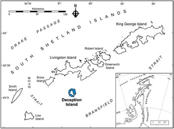
Deception Island (62°57'S, 60°38'W; Fig. 1) is a unique place in Antarctica with unusual natural, scientific, historical, educational, aesthetic and wilderness values. By Antarctic standards, Deception Island has also had a long history of human activity, of which scientific research has been one of the dominant uses in recent decades. The aim of this study was to examine the output of research activities that have taken place on or around Deception Island, as represented by published scientific articles. This type of analysis is of fundamental importance for assessment of the level of international co-operation that occurs in Antarctic scientific research.
Location of Deception Island. Inset map: northern Antarctic Peninsula and offshore islands.

Natural setting
Deception Island is one of the three known volcanoes in the South Shetland Islands. It is a horseshoe-shaped basaltic island, with a diameter of 15 km. It has a surface area of c. 98.5 km, with 57% permanently covered by ice (Smellie et al. Reference Smellie, López-Martínez, Headland, Hernández-Cifuentes, Maestro, Millar, Rey, Serrano, Somoza and Thomson2002). Neptune’s Bellows, a narrow passage on the south-east side of the island, enables entry of vessels into the flooded caldera, Port Foster, which was formed by an explosive eruption c. 10 000 years ago. The volcano is active and there have been small-scale eruptions during the last 200 years, with recorded events during 1906–10 and 1967–70 (Baker et al. Reference Baker, Mcreath, Harvey, Roobol and Davies1975). There are freshwater and geothermal springs on the island, as well as several lakes, freshwater pools, streams and a geothermal lagoon (Downie et al. Reference Downie, Convey, McInnes and Pugh2000). The climate is polar maritime, with a mean annual temperature of -3ºC (-28ºC to +11ºC) (Smith Reference Smith1984a, Reference Smith1984b). Vegetation is sparse as most volcanic substrata are porous, arid and unstable (Smith Reference Smith1984a, Reference Smith1984b, Reference Smith1988) but there are more than 70 species of moss, seven liverworts and 70 lichens on the island. Many of these species are associated with the geothermal soils, being unknown or very rare elsewhere in the Antarctic (Smith Reference Smith2005). Deception Island also features the largest known stand of Colobanthus quitensis (Kunth) Bartl., Antarctic pearlwort, one of only two flowering plants in the Antarctic (Deception Island Management Group 2012). The invertebrate fauna is dominated by terrestrial springtails (Collembola), mites (Acarina) and freshwater nematodes (Nematoda) (Downie et al. Reference Downie, Convey, McInnes and Pugh2000). There are also freshwater crustacea (Crustacea), one gastrotrich (Gastrotricha), tardigrades (Tardigrada), rotifers (Rotifera) and one fly (Diptera) (Deception Island Management Group 2012). Nine bird species breed on the island including petrels, Antarctic cormorants, greater sheathbills (Chionis alba Gmelin), skuas, gulls and terns (Bó & Copello Reference Bó and Copello2001), along with the world’s largest colony of chinstrap penguins at Baily Head (Naveen et al. Reference Naveen, Lynch, Forrest, Mueller and Polito2012). There are no breeding mammals on Deception Island, but Antarctic fur seals (Arctocephalus gazelle Peters), Weddell seals (Leptonychotes weddellii Lesson), crabeater seals (Lobodon carcinophagus Hombron & Jacquinot), southern elephant seals (Mirounga leonina L.) and leopard seals (Hydrurga leptonyx Blainville) are present on the beaches of the inner and outer coasts (Deception Island Management Group 2012). Studies of flora, fauna and soil microalgal recovery following volcanic eruptions make Deception Island one of the best-studied sites in the Southern Ocean for biodiversity (Fermani et al. Reference Fermani, Mataloni and van de Vijver2007). An increasing gradient of marine biodiversity has been detected from Fumarole Bay to Neptune’s Bellows, purportedly reflecting a post-eruption recovery trend (Barnes et al. Reference Barnes, Linse, Enderlein, Smale, Fraser and Brown2008).
Human activity
There has been human activity on Deception Island since c. 1820, including exploration, sealing, whaling, aviation, scientific research and, more recently, commercial tourism (Deception Island Management Group 2012).
British and American sealers hunted around the island in the early 19th century, introducing one of the earliest commercial activities to the Antarctic (Dibbern Reference Dibbern2010). From 1912–31, the Norwegian Hektor Whaling Company operated on a station in Whalers Bay. In 1944, the British expedition Operation Tabarin occupied one of the abandoned buildings of the Hektor whaling station, founding the first permanent station on the island. Argentina established Decepción Station at Fumarole Bay in 1948 and Chile founded Pedro Aguirre Cerda Station in Pendulum Cove in 1955. The Chilean base was destroyed by the volcanic eruption in 1967, while further eruptions in 1969 and 1970 destroyed many British installations at Whalers Bay by fire and mudslides, forcing abandonment. Neither the Chilean nor the British programmes returned.
Over the past 50 years, a number of countries have conducted scientific research around Deception Island in many areas of natural sciences, including biology, oceanography, geology and physics (Pertierra et al. Reference Pertierra, Tejedo and Benayas2014). In 2013, there were only two scientific stations in operation: Decepción Station (Argentina) and the Spanish Gabriel de Castilla Station (established in 1988), both stations only open during the summer. The two stations altogether are used by c. 60 researchers and support staff annually.
Commercial tourism on Deception Island began in 1966 when the environmentalist Lars-Eric Lindblad visited the island with his pioneer tourism model combining sight-seeing with educational lectures. Deception Island has developed to be one of the most visited tourist destinations in Antarctica. The majority of commercial tourists arrive on cruise ships and make landings of several hours at individual sites. In 2012–13, 24 293 tourists visited Deception Island at the four main sites of Whalers Bay, Telefon Bay, Baily Head and Pendulum Cove (similar to previous seasons; IAATO 2014).
Management
Deception Island was formally adopted as Antarctic Specially Managed Area (ASMA) No. 4 in 2005 at the 28th Antarctic Treaty Consultative Meeting (ATCM) under Measure 3. An ASMA is designated when a number of activities are being undertaken by several countries and there is a need for international co-operation to ensure appropriate environmental management. A management group is formed to oversee the planning and co-ordination of activities, prevent conflicts, improve co-operation and minimize environmental impacts. The Deception Island Management Group comprises representatives from six Antarctic Treaty consultative parties: Argentina, Chile, Norway, Spain, the UK and the USA (Argentina and Spain, and to a lesser degree Chile, UK and USA have active research on the island; Norway, UK and Chile have historic interests). There are several Antarctic Specially Protected Areas (ASPAs), Historic Site and Monuments (HSMs), a facilities zone and a series of visitors’ guidelines for Deception Island (Deception Island Management Group 2012). Hektor whaling station is considered to be the most significant historical whaling site in the Antarctic, and is listed as HSM No. 71. The abandoned Chilean station at Pendulum Cove is listed as HSM No. 76. Other protected areas on the island include ASPA No. 140, comprising 11 terrestrial sites of unique botanical importance, and ASPA No. 145, comprising two marine sites within Port Foster where a long-term scientific study is monitoring post-eruption re-colonization.
Materials and methods
Scientific output was measured by the number of scientific articles published in peer reviewed journals arising from scientific research on or around Deception Island. This strategy had multiple advantages: i) the information is easily accessible in several public databases, ii) the peer review process guarantees, to some degree, the quality of included research, and iii) only successful scientific activities are incorporated, discarding those that did not generate scientific knowledge of interest.
Databases
Bibliographic search engines were used to identify articles using the search string ‘Deception Island Antarctica’. An initial list was compiled using Web of Science, Google Scholar, Scirus, Combined Antarctic and Cold Regions Bibliographies, the databases of the Australian Antarctic Data Centre, British Antarctic Survey, the Spanish Polar Data Centre and University of Cadiz’s (Spain) alphanumeric database with georeferenced bibliography for Deception Island (http://simac.uca.es/). Papers were filtered using the following criteria: i) published pre-2013, ii) published in scientific journals listed in Thomson Reuters’ 2011 Journal Citation Reports (JCR), and iii) only papers that provided new data about Deception Island were kept. Each paper was supplemented by basic information including year of publication, journal name, authors, full title and summary.
Once the basic database was compiled, each paper was assigned to one of eight topic categories: i) volcanology and seismology, ii) terrestrial biodiversity, iii) marine biodiversity, iv) geology, geomorphology and stratigraphy, v) limnology and microbiology, vi) oceanography, vii) human dimension, and viii) glaciology, meteorology and climate. Topics were defined following analysis of the main issues addressed in the whole collection of papers. Topic assignment was based on the objectives and results of the paper, regardless of the content of the discussion section. Most of the papers were assigned to a single category. However, a small fraction (17 articles, 9.8%) possessed a multidisciplinary design, in which case the secondary topic was also designated. Exceptionally, one paper addressed three of the categories. To complete the categorization process, the methodology sections were reviewed to distinguish the geographical distribution of fieldwork. Studies in which research was conducted in different parts of the island (i.e. more than four sites) were assigned to a ‘global’ category. A special category was created to accommodate papers that did not cite the geographical point of research.
From the database, a list of journals in which the papers were published was assembled. For each journal, the following information was obtained from Thomson Reuters’ JCR: 5-year impact factor, country of publication and subject categories. For each journal, the total number of papers and the time period over which these papers were published was tabulated.
A second database was also compiled, which contained papers on all Antarctic research activity, spanning 1964–2012 (the same period as the Deception Island database), in order that comparisons could be made with regard to the historical evolution of scientific research on Deception Island. The all Antarctic database was compiled from searches on the Web of Science’s Science Citation Index - Expanded (SCI-E) and Social Science Citation Index (SSCI). Following the methodology used by Dastidar (Reference Dastidar2007), papers containing terms beginning with ‘antarc*’ in the title were selected. Only scientific papers, i.e. research articles, reviews and notes, were selected. Letters, communications, news items, publishing materials and other non-scientific publications were not included.
Social network analysis
Social network analysis is a tool which generates matrices consisting of nodes (which represent individual actors) and ties (which represent relationships between the actors). In this study, four classes of nodes represent topics, nations, institutions and authors. The ties represent scientific collaborations. Nations for each scientific article were defined using the information provided by authors in the affiliation section. Affiliation was also used to identify the institution. All co-authors of each scientific article were included individually.
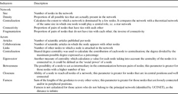
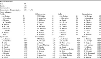
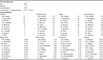
Two specific matrices were created for each class of node, one with the number of interactions between pairs of nodes and another with only binary data indicating the existence of collaborations between nodes (0/1). This was necessary as certain analyses are only possible with binary data. Statistical analysis was performed using UCINET 6.85 (Borgatti et al. Reference Borgatti, Everett and Freeman2002). At the network level, five indicators were obtained: size, density, centralization, connectivity and fragmentation (Table I). At actor/node level, the following data were obtained: articles, collaborations, links, centralization, eigenvector, betweenness, closeness and farness (Table I). These were depicted graphically using NetDraw 1.48 (Borgatti Reference Borgatti2002). The relative size of the points in these diagrams indicates the relative output (number of articles) for each node, whereas the lines between points indicate collaboration links, and line thickness indicates the strength of the interconnections.
Statistics used in the social network analysis.

Application of social network analysis to the study of scientific output on Deception Island has numerous advantages: i) highlighting topics which have been the focus of research, ii) determination of the degree of multidisciplinarity of research, iii) assessment of the internationalism of scientific articles, iv) identification of institutions that have been active in improving the scientific knowledge of Deception Island, v) identification of the most productive researchers, and vi) identification of scientists that engage most in collaboration.
Results
Topics and publication rates
The Deception Island database contained 173 articles (see supplemental material for a list of the scientific papers in the database, found at http://dx.doi.org/10.1017/S0954102014000455).
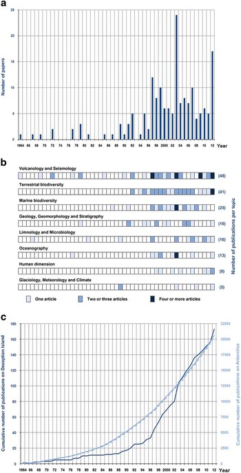
Between 1964 (first record) and 2012, the average publication rate was 3.5 ± 0.36 (standard error) papers per year. Until the mid-1990s papers were published irregularly (Fig. 2a), since then articles have been published annually, often five or more publications per year. Publication rates were highest in 2003 (n=24), 2012 (n=17) and 1997 (n=12). In 2003, a special issue on Deception Island was published in Deep-Sea Research Part II - Topical Studies in Oceanography, which included 15 papers focusing on marine biodiversity and oceanography.
Scientific papers published between 1964–2012 reporting research activities that took place on Deception Island. a. Number of papers published per year. b. Number of papers by topic. Darker colour indicates a greater number of publications per year, the total number of papers by topic is indicated on the right. c. A comparison of the cumulative scientific publications on Deception Island and on Antarctica as a whole. The dark blue line indicates the cumulative number of scientific papers on Deception Island (left axis). The solid light blue line shows the cumulative number of scientific papers on Antarctica (right axis) based on searches on the SCI-E and SSCI databases, the dashed light blue line shows only the papers featured on the SCI-E database.

The topic with the highest number of publications was volcanology and seismology (n=48), followed by terrestrial biodiversity (n=41). Terrestrial biodiversity included numerous papers dedicated to the singular communities of bryophytes and mosses that appear on the island, and studies focused on penguins. These topics combined represented > 50% of the articles. There were 25 articles published on marine biodiversity, describing the different biological communities living in Port Foster. There were 16 papers on geology, geomorphology and stratigraphy and on limnology and microbiology. Oceanography (n=13) included the results of various oceanographic campaigns conducted by Spanish, Argentinean and USA researchers in the waters around Deception Island. Studies focused on human presence and its impact on the environment (human dimension) were less common (n=9), as were studies dedicated to glaciology, meteorology and climate (n=5).
Analysis of the temporal trends by topic (Fig. 2b) demonstrated that publication of volcanology and seismology papers presented peaks: 1997 (n=4), 2003 (n=5), 2009 (n=4) and 2012 (n=7). As with most of the topics, publications in this category were concentrated in the last two decades. During this period, papers were also regularly published on terrestrial biodiversity with two to three publications per year. The annual publication rate for marine biodiversity was generally lower. Papers within other topics were also mostly published during the last 20 years, but there were numerous years in which there were no publications.
The whole Antarctic database contained 20 688 articles published between 1964–2012 (solid light blue line in Fig. 2c). The majority of the papers were scientific articles (95.4%), followed by notes (2.4%) and reviews (2.2%). Publications on social science research (SSCI database) represented < 3% (n=286) of the total number of scientific publications. The greatest scientific output was in 2012 (996 papers), while in 1964 only 34 scientific papers were listed in the Web of Science database. It is recognised that the listings for pre-1980 are significantly incomplete. The number of scientific publications focused on Antarctica has been increasing, the trend can be approximated by a sustained model: Y=18.87 X 1.7083, r 2 =0.9732 (data shown in Fig. 2c, solid dark blue line). In comparison, the accumulated scientific output for Deception Island is irregular. The increases in recent years produce data that can be approximated by an exponential model described by: Y=1.2983 e 0.1039X (r 2 =0.98) (data shown in Fig. 2c, solid light blue line). The dashed blue line in Fig. 2c shows only the papers collected in the SCI-E database (20 402 articles), excluding the social science research papers.
Study locations
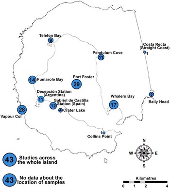
Most of the articles in the Deception Island database (n=130, 75.1%) included information on the geographical location of the fieldwork (Fig. 3). Within this group, 43 (24.8%) studies conducted fieldwork over the whole island (more than four sites) and 87 (50.3%) collected data at one to three specific sites. Port Foster was the most studied location (n=29), followed by Vapour Col (n=28), Whalers Bay (n=17), Fumarole Bay (n=14), the vicinity of the scientific stations (Gabriel de Castilla Station n=12 and Decepción Station n=11), and Pendulum Cove (n=11). These sites were mostly located inside Port Foster and close to the coastline, facilitating access from the inner bay. The exception was Vapour Col, which is the location of a penguin colony outside the caldera. All of these locations have outstanding values including thermal anomalies, hot springs, unique plant communities and, in some cases, historical sites. The remaining articles (n=20) were distributed among Telefon Bay, Crater Lake, Baily Head, Collins Point and Costa Recta. Finally, 43 publications (24.8%) did not provide specific data regarding the location of fieldwork sites.
Geographical locations of fieldwork. Of the 173 papers, 87 clearly specified the location of the research (some fieldwork was conducted on more than one site), 43 studies conducted fieldwork over the whole island, and 43 publications did not identify the specific location of the research.

Journal profiles
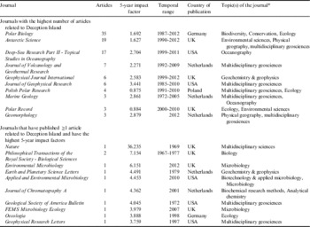
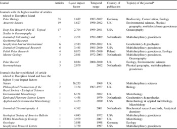
Papers on Deception Island have been published in 72 journals. Most journals have published one (n=54, 75.0%) or two papers (n=8, 11.1%). The ten journals with the highest numbers of papers, published 59.5% of the papers on the database (Table II), indicating that scientific publications on Deception Island are concentrated in a few journals (following Bradford’s Law). The most popular journals were Polar Biology (n=35, 20.2%) and Antarctic Science (n=19, 11.0%). Journals with the largest number of publications were typically multidisciplinary and had a 5-year impact factor of <3.7. Journals with a 5-year impact factor of >3.7 tended to have published only one article on Deception Island, indicating a higher subject specialization, with some exceptions (e.g. Nature, Geological Society of America Bulletin and Geophysical Research Letters).
Journals that have published scientific research articles related to Deception Island.
*According to the JCR database information.
Relationships between topics, nationalities, institutions and authors
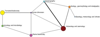
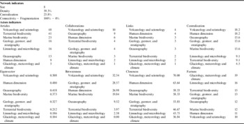
The network of topics (Fig. 4) was composed of eight nodes, which had c. 40% of the possible ties between pairs of nodes (Table III). No single topic acted as a global link to all others. As a result, the centralization degree of this network was low (23.8%). It had 100% connectivity since all agents belong to the network. However, the number of collaborations shows that multidisciplinary research was limited. In fact, only 10.4% of articles (n=18) could be assigned to two or more categories. The more connected topics were volcanology and seismology (n=4) and human dimension (n=4). Studies in glaciology, meteorology and climate, which were low in number (n=5), occupied a peripheral position in the network with low connectivity.
Network of research topics from Deception Island. Each node represents a topic of research, represented by a different colour. Node size indicates the number of articles per topic. The lines represent the existence of papers in which both topics are considered.

Indicators for the topic network.

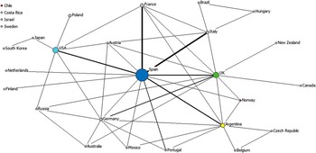
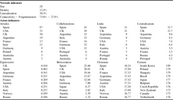
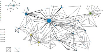
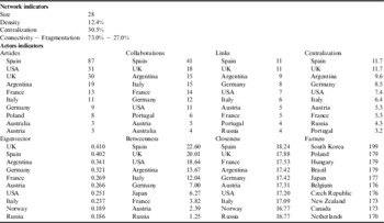
In the network of nationalities (Fig. 5), there were 28 nodes. Of these, 21 were consultative parties to the Antarctic Treaty (Argentina, Australia, Belgium, Brazil, Chile, Czech Republic, Finland, France, Germany, Italy, Japan, Netherlands, New Zealand, Norway, Poland, Russia, South Korea, Spain, Sweden, UK and USA), four were non-consultative parties (Austria, Canada, Hungary and Portugal) and three were not party to the Antarctic Treaty (Costa Rica, Israel and Mexico). The density of this network could be considered as low (12.4%, Table IV), the centralization was limited (30.5%) and the degree of connectivity was high (73.0%). These data correspond to a network in which the number of links between nations was medium–high but where the number of collaborations was often low, i.e. limited to a single joint publication. Spain (n=87), USA (n=31) and UK (n = 30) held the highest rank in terms of number of items. Spain (n=41) and UK (n=18) presented the highest collaboration and centralization values, and acted as a link between nations that were not directly related. Chile, Costa Rica, Israel and Sweden were isolated as they have not collaborated with any other countries.
Nations producing scientific publications based on research from Deception Island. Each node represents the nationality of the institutions producing the scientific papers. The size of the node indicates the number of articles per nation. Lines link nations where their institutions share authorship of articles. Nations that are part of the Deception Island Management Group are represented by coloured nodes.

Indicators for the nationality network.
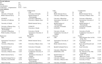
The network for the institutions that have generated publications had a high degree of fragmentation (56.4%, Table V, Fig. 6). Of the 124 institutions, 11 had never collaborated, 12 had collaborated with only one other, and eight had relationships with three other institutions. The Spanish National Research Council (CSIC) stood out in terms of its number of publications (n=47), collaborations (n=74) and links with other nodes (n=30). This research centre acts as a bridge between different institutions, presenting high centrality and connectivity values. Institutions belonging to nations that form the Deception Island Management Group have a large number of publications, collaborations and links (Fig. 6). The isolation of a significant number of institutions, which have a low level of collaboration with research centres from other countries, is remarkable.
Institutions participating in the publication of scientific research from Deception Island. Each node represents an institution. The size of the node indicates the number of articles per institution. Lines represent co-authorship between institutions. Institutions from nations that are part of the Deception Island Management Group are represented by coloured nodes: Spain=dark blue, UK=green, Argentina=yellow, USA=light blue, Chile=red, Norway=pink. The institutions with the highest numbers of publications are numbered: 1=The Spanish National Research Council (CSIC), 2=University of Granada, 3=British Antarctic Survey, 4=National Scientific and Technical Research Council (CONICET), 5=University of California, 6=University of Alcalá, 7=University of Buenos Aires, 8=Spanish Institute of Oceanography, 9=University of Barcelona, 10=Polish Academy of Science.

Indicators for the institutions network.

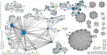
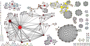
The networks by author are shown in Figs 7 & 8 (authors were assigned to the country in which they usually worked, although some researchers had temporary positions in other centres while conducting specific research). This network was the largest in the study with 400 authors (175 worked in a Spanish institution) (Table VI). It is also the most fragmented (91.5%), with 14 isolated authors, 16 only collaborating with one other researcher, 36 working with only two colleagues, and 32 forming groups of four authors. Five sub-networks have been identified in Figs 7 & 8 by letters (a–e); as a result of their large size they have been considered as the most important. Sub-net a was dominated by USA authors working in oceanography, marine biodiversity, and glaciology, meteorology and climate. Sub-net b was primarily composed of Spanish authors who were investigating terrestrial biodiversity; this sub-net included some of the most productive authors, many of whom specialized in the study of penguins and regularly collaborated with each other. Sub-net c mainly consisted of Spanish, British and Argentinean authors that specialized in geosciences. Sub-net d was dominated by Spanish authors dedicated to marine biodiversity and oceanography. Sub-net e was composed of 23 authors (within three articles, one of which generated the rosette structure due to including all of the authors in this sub-net). Other topics (limnology and microbiology, and human dimension) tended to appear in sub-nets of smaller sizes, indicating that these papers were conducted by scientists who did not collaborate with other research groups. Only four multidisciplinary scientists were identified (i.e. researchers with publications on three different topics). A number of authors (n=29) had published research in two topic areas; however, of these, 13 authors had > 75% of papers from, and were therefore assigned to, a single topic (Fig. 8).
Co-authorship networks by nationality. An attempt to show the level of interaction between researchers. Each node represents a single researcher, and the size of the node indicates the number of publications by each author. The lines represent co-authorship. The authors that have published the highest numbers of papers are represented by numbers: 1=Jesús M. Ibáñez, 2=Javier Almendros, 3=Juan Moreno, 4=Juan A. Fargallo, 5=Andrés Barbosa, 6=Ana De León, 7=Edoardo Del Pezzo, 8=John L. Smellie, 9=Ana Ramos, 10=Jaime Potti. Letters are used to identify networks cited in the text.

Co-authorship networks by topic. Each researcher is identified by area of specialization. Topics are represented following those colours used in Fig. 4: brown=volcanology & seismology, yellow=terrestrial biodiversity, pink=marine biodiversity, orange=geology, geomorphology and stratigraphy, green=limnology and microbiology, light blue=oceanography, purple=human dimension, dark blue=glaciology, meteorology and climate. Authors that had publications in more than one topic, but specialized in one area (≥ 75% of papers) are represented with a single colour; if a specialization was not clear, both colours are shown. Red nodes represent authors considered multidisciplinary (papers in three or more topics): 1=Jesús M. Ibáñez, 2=John L. Smellie, 3=Roberta J. Baldwin, 4=Henry A. Ruhl. Letters are used to identify networks cited in the text.

Indicators for the author network.
Discussion
Difficulties in building the database of scientific papers
The creation of the scientific publication databases was a complicated task that highlighted the difficulty of obtaining a complete database without biases and errors. Similar studies for Antarctica as a whole have already faced this problem (Dastidar & Persson Reference Dastidar and Persson2005, Dastidar Reference Dastidar2007, Aksnes & Hessen Reference Aksnes and Hessen2009, Stefenon et al. Reference Stefenon, Roesch and Pereira2013). Bibliographic search engines generated lists of references that had to be carefully screened to avoid inclusion of articles in which Deception Island is mentioned but new scientific data are not reported. This required manually checking each reference. First, key elements were consulted (title, keywords, abstract), and a second review of the main text was done for certain papers. Despite comparing different databases and several reviews focused on Deception Island (Spain 2010, http://simac.uca.es/, accessed March 2013), we assume that some papers will not appear within the final list. There is the further problem of the emphases of current on-line databases being from 1980 onwards, so that coverage of earlier publications is both incomplete and patchy.
Another issue that may generate debate is the focus on papers published in indexed journals. This methodology may omit numerous scientific research papers and may lead to significant bias. However, as many of the un-indexed journals are not part of the principal bibliographic search engines, inclusion would make it almost impossible to close the list of selected references. Furthermore, un-indexed journals do not always have a peer-review system to ensure the quality of their articles. The aim of this study was to identify general trends, and this is possible using the list of publications herein.
Research trends: multidisciplinarity and international co-operation
The volcanic nature of Deception Island has prompted the development of numerous studies on volcanology and seismology. The biological value of the terrestrial ecosystems has made terrestrial biodiversity the second most studied topic. The temporal evolution of the number of publications within each topic has shown that scientific output in recent years has increased and diversified (Fig. 2). This trend is in agreement with other studies for the Antarctic (Aksnes & Hessen Reference Aksnes and Hessen2009, Stefenon et al. Reference Stefenon, Roesch and Pereira2013), which attribute this increase to the implementation of public policies and international initiatives that support polar research, i.e. the International Polar Year 2007–09. Although there has been diversification in research, there are few multidisciplinary works, i.e. papers dedicated to two or more topics, and reviews are not abundant. The analysis of the network of authors shows that there is a lack of interaction between scientists from different fields (Fig. 8). Multidisciplinarity is not common practice on Deception Island; this is seen as a disadvantage since multidisciplinarity can be highly positive for the progress of scientific knowledge.
The Antarctic Treaty encourages international co-operation in scientific research. This study shows a high level of internationalization in terms of scientific output. Scientists from a large number of countries have performed research on Deception Island, although the scientific articles were dominated by the nations with a strong interest in Antarctica, i.e. consultative and non-consultative parties to the Antarctic Treaty. Four of the six nations that form the Deception Island Management Group (Spain, USA, UK and Argentina) have produced most of this work. These nations are also notable for their collaborations and links with other countries, showing active research interests in the area. The other two members of the management group, Chile and Norway, have mainly historic interests on the island. Spain is the most productive and collaborative nation, with the highest centrality, serving as a bridge between nations that do not collaborate directly. The establishment of the Gabriel de Castilla Station (which has been used every summer since 1988) has contributed significantly to the output of Spanish scientific research. Further analysis of the extent of international scientific collaboration reveals additional trends. For example, many British and USA institutions are not part of the main network. For the authors, there is less collaboration between researchers from different countries, with many articles being written by scientists from a single country. This trend does not match the results obtained by Aksnes & Hessen (Reference Aksnes and Hessen2009) for published papers devoted to both polar regions during the period 1981–2007. They observed an increase in the number of internationally co-authored papers in recent years. Of publications from Deception Island, 33.5% (n=58) were co-authored by contributors from different countries. This value is similar to that obtained by Dastidar (Reference Dastidar2007) for Antarctica as a whole (34.4%), but is low relative to results obtained by Benayas et al. (Reference Benayas, Pertierra, Tejedo, Lara, Bermúdez, Hughes and Quesada2013) on Byers Peninsula (66%). As shown by Bartneck & Hu (Reference Bartneck and Hu2010), higher levels of collaboration in multidisciplinary fields increase the scientific output associated with each investigation. The analysis of the Deception Island database shows lower multidisciplinary and international co-operation than other polar areas, and lower than the average for all of Antarctica. The results of this study could be used to improve scientific collaboration on Deception Island enabling researchers to identify new working partnerships. It may also identify scientists who are collaborating with different teams and may be an asset in a multidisciplinary project.
Connecting research and management
The Deception Island database has a wide range of uses, including supporting the periodic review of the Deception Island management plan, according to the Protocol on Environmental Protection to the Antarctic Treaty. This up-to-date and reliable scientific knowledge could be integrated into the management processes. Furthermore, the authors network could be used to identify the most productive researchers in different topics, and these experts could be contacted by the management group for consultation on specific issues related to conservation or management.
The recent increase in scientific publications is directly related to the increase in researchers on Deception Island (Fig. 2; Pertierra et al. Reference Pertierra, Tejedo and Benayas2014). This trend is common to Antarctica as a whole (Hughes et al. Reference Hughes, Pertierra and Walton2013). However, a higher scientific presence could lead to increased pressure on Deception Island’s ecosystems, becoming a threat for the conservation of this site. To avoid negative impacts, it is necessary to keep, respect and, if necessary, improve the comprehensive and robust protected area system that has been developed for Deception Island. The spatial distribution analysis of the research conducted on Deception Island (Fig. 3) may serve as a useful monitoring tool, by identifying sites that receive greater attention from scientists, or areas that are less well studied. This information may also be useful in the quantification of the environmental footprint of researchers and their activities in Antarctica (e.g. Jabour Reference Jabour2009, Summerson & Tin Reference Summerson and Tin2011, Hughes et al. Reference Hughes, Fretwell, Rae, Holmes and Fleming2011). Nonetheless, only a proportion of the research undertaken in Antarctica will generate a publication, therefore, the environmental impact of the unpublished work will not be accounted for. Finally, the database may be useful to direct future scientific research on the island.
Strengths and weaknesses of this research and future opportunities
This study assessed the scientific output, distinguishing contributions made by each country, research institution and author, thereby generating valuable information that can contextualize scientific research carried out on Deception Island. The use of statistical parameters from the social network analysis method facilitates quantification of the relationships between the contributors. These metrics go a step further from the qualitative descriptions of social network diagrams used in previous studies (Dastidar Reference Dastidar2007, Benayas et al. Reference Benayas, Pertierra, Tejedo, Lara, Bermúdez, Hughes and Quesada2013). However, the applied methodology has some limitations. For example, a single collaboration between two actors incorporated them into the same network, thereby generating large networks with high connectivity but low density. In spite of this, the use of statistics at actor and network level enables a comprehensive analysis of the data beyond graphical representation. An additional problem in a network with numerous nodes is the inherent difficulty with identification of specific actors. This is demonstrated in the institution and author networks presented here (Figs 6, 7 & 8).
The database provides valuable information that can be used to orient the direction of further research on Deception Island. It would be appropriate to apply this approach to other Antarctic areas (South Shetland Islands, Antarctic Peninsula, Ross Sea region, etc.) and to Antarctica as a whole, expanding the analyses by Dastidar (Reference Dastidar2007) and Aksnes & Hessen (Reference Aksnes and Hessen2009). The main obstacles for these new studies would be: i) creating and screening bibliographic databases and ii) elaboration of relationship matrices. It is essential to thoroughly review the output generated by bibliographic search engines, aiming to avoid inclusion of articles unrelated to the study area. After selecting the papers, the creation of relationship tables can be a slow process due to the complexity of automating this task. The approach presented here would be best applied for specific Antarctic sites with a limited volume of published scientific articles (< 500). The spatial analysis was the most complex task to develop. The wide variability in the quality of geographical information provided in the papers meant that it was necessary to combine several sources of information to get a result close to reality. It would be interesting to compare the spatial analysis results with the information submitted to the Electronic Information Exchange System (EIES). The EIES is a database, established in September 2008, for the collection of all information required in the Treaty, the Protocol and its Annexes, and the relevant measures of the ATCM. It includes pre-season information, describing planned activities for the forthcoming year, and an annual report, providing an update on activities undertaken in the preceding year. Although information exchange is a fundamental principle upon which the Antarctic Treaty was founded, its use is not yet widespread (Pertierra & Hughes Reference Pertierra and Hughes2013). However, an improvement in the effectiveness of current information exchange practices in the medium term is expected, enabling the development of this type of analysis.
Conclusions
The approach presented in this paper has enabled quantification of the scientific output of Deception Island between 1964–2012, thereby assessing the degree of multidisciplinarity and international co-operation between scientists. The database enabled identification of topics that have received the most attention from the international scientific community. Volcanology and seismology and terrestrial biodiversity were the topics with a greatest number of publications, although in recent years the scientific output has diversified boosting other themes. Multidisciplinary research is still uncommon, most of the articles were devoted to a single topic. The contribution made by each country, research institution and scientist was also established. Our results show the significant role of four of the six nations that form the Deception Island Management Group, with Spain at the forefront of scientific output. Collaboration among research centres and scientists was limited. These results support the need to strengthen international co-operation regarding scientific activity. International co-operation will improve information sharing/exchange, enhance research in Antarctica, and reduce the environmental impact. It is highly desirable to implement similar studies of the scientific output associated with key sites in Antarctica in order to maximize synergies and collaborations among researchers and different nations. The network diagrams and statistics obtained with the approach presented here identify key players (country, research institution or scientist) and give weight to the specific contribution of each. Obtaining numerical data to evaluate international scientific collaboration is not easy, and identifying who co-operates is even more complicated. By using Deception Island as a case study, we have demonstrated how to approach this issue in an effective way.
Acknowledgements
This paper is a contribution of several projects supported by the Spanish Government (grant No. CGL2007-28761-E/ANT, CTM2009-06604-E and CTM2010-11613-E). The authors would like to thank Óscar Bermudez (Spanish Polar Data Centre) for providing an initial database of works developed on Deception Island, and Dr Tina Tin for her constructive and helpful comments, which contributed to improving this paper. Many thanks also for the suggestions by three reviewers and the editors.
Supplemental material
A supplemental list of papers from the database will be found at http://dx.doi.org/10.1017/S0954102014000455.