


1. Introduction
Palaeogeography provides the spatial and temporal framework needed to interpret biogeography and phylogenetics, as evolutionary processes occur within a spatial context and are intrinsically linked to patterns of species distribution (e.g. Brikiatis, Reference Brikiatis2020; Landis et al. Reference Landis, Cracraft and Sanmartín2026). Consequently, researchers working in biogeography and phylogenetics have a strong interest in the palaeogeographic evolution of Earth and its precise chronological and spatial context. Advances in geophysical and geological research are not automatically translated into improved palaeogeographic reconstructions. Rather, new data require specialized processing and integration, particularly when assessing the timing and configuration of terrestrial and marine connections and barriers. This study capitalizes on recent geophysical advances from the Southern Mozambique Basin – a critical region for reconstructing the breakup of Gondwana – to constrain the timing and configuration of continental connections and separations in one of the least well-constrained yet widely debated palaeogeographic regions of the Earth: the southern continents during the early Cretaceous.
The southern continents, including South America, Africa, Madagascar, India, Antarctica, and Australia, were once accreted into the Gondwana supercontinent. During the breakup of Pangaea, Gondwana became terrestrially separated from Laurasia by the establishment of the Atlantic seaway (Enay, Reference Enay1980), or Hispanic Corridor (Smith, Reference Smith1983), a marine connection between the Pacific and Atlantic oceans through present-day Central America. A biogeographical analysis of marine faunal exchange suggests that complete and continuous exposure of this seaway started at the early Callovian (∼165 Ma; Sandoval et al. Reference Sandoval, Westermann and Marshall1990), although sporadic marine faunal exchange may have taken place earlier during periods of high sea level (e.g. Moyne et al. Reference Moyne, Neige, Marchandet and Thierry2004, and references therein). Geologically, the formation of the Atlantic seaway is documented, probably as a deep-water connection, at approximately 160.6 Ma (middle Oxfordian, late Jurassic; Brikiatis, Reference Brikiatis2017, and references therein).
The terrestrial separation between West Gondwana (Africa–South America) and East Gondwana (Antarctica–Australia–Indo-Madagascar) was accompanied by the establishment of the trans-Gondwana seaway [also termed the Austral Seaway (‘La voie australe;’ Enay, Reference Enay1980), the Gondic (trans-Gondwana) Corridor (Krishna, Reference Krishna1996) or the Mozambique Corridor (Damborenea et al. Reference Damborenea, Echevarría and Ros-Franch2013)], which connected the Tethys Ocean to the north and northeast with the Palaeo-Pacific to the south. Some researchers have also used the term ‘Trans-Erythraean trough’ to refer to this seaway (e.g. O’Gorman et al. Reference O’Gorman, Gouiric-Cavalli, Scasso, Reguero, Moly and Acosta-Burlaille2018; Kietzmann and Scasso, Reference Kietzmann and Scasso2020); however, this usage is incorrect. According to Arkell (Reference Arkell1956), the Trans-Erythraean trough was introduced by Lamare (Reference Lamare1936) to describe a marine passage between Africa, India and Madagascar (see map in Arkell, Reference Arkell1956, fig. 44). It has not been formally associated with a more southerly marine continuation and should therefore not be used to refer to the fully open marine corridor extending from the Tethys to the Palaeo-Pacific. The final breakup of East Gondwana led to the opening of the eastern Indian Ocean and terrestrial separation of Indo-Madagascar from Antarctica and Australia.
The fragmentation of the southern continents played a critical role in shaping the evolution of modern biotas in the Southern and Northern hemispheres through vicariant processes (e.g. Sanmartín and Ronquist, Reference Sanmartín and Ronquist2004; Upchurch, Reference Upchurch2008; Krause et al. Reference Krause, Sertich, O’Connor, Curry Rogers and Rogers2019). Vicariant phylogenetic patterns remain difficult to test, however, because the timing of key palaeogeographic events is poorly constrained. Various phylogeographic studies have invoked markedly different ages for the separation of East and West Gondwana, ranging from ∼170 Ma (e.g. Hauenschild et al. Reference Hauenschild, Favre, Michalak and Muellner-Riehl2018; Derkarabetian, Baker and Giribet, Reference Derkarabetian, Baker and Giribet2021) to ∼130 Ma (e.g. Bossuyt and Milinkovitch, Reference Bossuyt and Milinkovitch2001; McLoughlin, Reference Mcloughlin2001; Gallaher et al. Reference Gallaher, Callmander, Buerki and Keeley2015; Grímsson et al. Reference Grímsson, Graham, Coiro, Jacobs, Xafis, Neumann, Scott, Sakala, Currano and Zetter2019; Derkarabetian et al. Reference Derkarabetian, Baker and Giribet2021). Such discrepancies substantially increase the uncertainty of biogeographic interpretations. Therefore, establishment of a precise timetable for palaeogeographic events is essential for understanding the evolution of life and palaeoenvironmental changes on Earth.
2. Geological and tectonic framework
The breakup of East and West Gondwana and the establishment of the trans-Gondwana Seaway resulted from a prolonged phase of tectonic reorganization. During the late stages of Gondwana assembly and evolution (late Carboniferous–Triassic; ∼300–205 Ma), widespread extensional tectonics generated a series of intracontinental rift systems infilled by thick terrigenous and carbonate successions (Salman and Abdula, Reference Salman and Abdula1995; Catuneanu et al. Reference Catuneanu, Wopfner, Eriksson, Cairncross, Rubidge, Smith and Hancox2005). These sedimentary accumulations are collectively referred to as the Karoo Group, a broadly distributed stratigraphic succession extending across much of southern Africa and spanning the Upper Carboniferous to Lower Jurassic interval (Salman and Abdula, Reference Salman and Abdula1995).
The initial phase of rifting during Permian–Triassic times was associated with regional E–W extension (e.g. Roche et al. Reference Roche, Leroy, Guillocheau, Revillon, Ruffet, Watremez, D’acremont, Nonn, Vetel and Despinois2021, and references therein). It was mainly characterized by localized, fault-bounded rifts in central and East Africa interpreted as intracontinental rifting. In the northern Somali Basin, incursions of Palaeo-Tethys seawater may have occurred along the axial part of the depression (Salman and Abdula, Reference Salman and Abdula1995).
By the end of the Triassic, intracontinental rift basins had formed extensively across present-day east and southern Africa (Karoo Basin), Madagascar, Australia, India and other regions. These basins were filled with strata composed predominantly of terrestrial fluvial, lacustrine and swamp deposits (Catuneanu et al. Reference Catuneanu, Wopfner, Eriksson, Cairncross, Rubidge, Smith and Hancox2005; Torsvik and Cocks, Reference Torsvik and Cocks2013). A new phase of breakup began in the Jurassic and was associated with emplacement of the main phase of the Karoo Large Igneous Province between 184 and 181 Ma (Duncan et al. Reference Duncan, Hooper, Rehacek, Marsh and Duncan1997; Jourdan et al. Reference Jourdan, Féraud, Bertrand, Watkeys and Renne2007).
By the late Jurassic, continued extension between East and West Gondwana progressed to organized seafloor spreading within the Mozambique and Somali basin systems. This stage of continental breakup led to pronounced segmentation of the East African margin, producing a complex arrangement of divergent and transform-margin sectors (Mueller and Jokat, Reference Mueller and Jokat2019).
In the northern sector, southward displacement of the Madagascar–India plate along the Davie Fracture Zone initiated opening of the Somali Basin. Farther south, relative southward motion of the Antarctica–Australia plate with respect to Africa along the Mozambique Fracture Zone accompanied development of the Mozambique Basin. In the southwestern sector, separation of the Patagonia plate from southern Africa occurred along the Agulhas–Falkland Fracture Zone, when oceanic spreading became established within the Southern Natal Valley (e.g. Mueller and Jokat, Reference Mueller and Jokat2019; Thompson et al. Reference Thompson, Moulin, Aslanian, De Clarens and Guillocheau2019).
The orientation of the earliest rifting and seafloor-spreading phases provides important constraints on the tectonic evolution of Gondwana breakup. On the basis of magnetic data from the central Mozambican margin, Mueller and Jokat (Reference Mueller and Jokat2017) identified anomaly M38.2 (∼164 Ma) as the oldest recognized spreading signal and inferred an early NW–SE-directed spreading phase in the Mozambique Basin, followed later by a shift to N–S-directed spreading (Mueller and Jokat, Reference Mueller and Jokat2019). The initial NW–SE phase may record the earliest relative motion between Africa and Antarctica (e.g. Gaina et al. Reference Gaina, Torsvik, Van Hinsbergen, Medvedev, Werner and Labails2013; Reeves et al. Reference Reeves, Teasdale and Mahanjane2016), whereas the later reorganization at anomaly M26r (∼157 Ma; Mueller and Jokat, Reference Mueller and Jokat2019) was accompanied by the development of N–S-directed strike-slip motion. Using a reconstruction in which the Northern Natal Valley is interpreted as continental crust, Thompson et al. (Reference Thompson, Moulin, Aslanian, De Clarens and Guillocheau2019) instead proposed synchronous N–S-oriented oceanic spreading within both the Mozambique and Somali basins by anomaly M25 (∼153 Ma). This reorganization was accompanied by a marked acceleration of Africa–Antarctica separation and, in the Reeves model, by a southward jump of the active ridge beneath the Mozambique Plains at approximately 151–150 Ma (Reeves et al. Reference Reeves, Teasdale and Mahanjane2016; Reeves, Reference Reeves2018; Macgregor and Reeves, Reference Macgregor and Reeves2025). The resulting reorganization of the ridge–transform network provides a plausible tectonic mechanism for the establishment of a restricted marine passage through the Africa–Antarctica Corridor at approximately 150 Ma or shortly thereafter.
The breakup between East and West Gondwana was followed by fragmentation within East Gondwana, resulting in the separation of the Madagascar–Seychelles–Greater India block on one side and the Australia–Antarctica block on the other side (Royer and Coffin, Reference Royer and Coffin1992). Geological evidence and plate reconstructions suggest that the continental areas between the Gunnerus Ridge and the Lambert Rift (Enderby Basin) of Antarctica were juxtaposed against the Pranhita–Godavari and Mahanadi grabens along the eastern margin of India, respectively (Smith and Hallam, Reference Smith and Hallam1970) (Figure 2). However, the absence of clearly identifiable M-series magnetic anomalies in the Bay of Bengal, together with ambiguous signatures of Mesozoic magnetic anomalies in the Enderby Basin of East Antarctica, leaves the timing of breakup and the early kinematics of seafloor spreading poorly constrained. In addition, post-breakup volcanism and the broad, poorly resolved continent–ocean transition zones along the segments of these margins further obscure the early history of seafloor spreading (Rao and Radhakrishna, Reference Rao and Radhakrishna2021, and references therein). The oldest magnetic anomaly recorded between the continental margins of the two regions is M11 (∼133 Ma), identified offshore from the Enderby Basin of Antarctica and the Bay of Bengal margin of India (Ramana et al. Reference Ramana, Ramprasad and Desa2001).
Suggested configuration of the southern continents during the Oxfordian (late Jurassic). The magenta dashed line marks the area of the trans-Gondwana corridor, whose full exposure separated West and East Gondwana. Magenta circles indicate the narrowest segments of the corridor, which were critical for its complete opening from the Tethys to the Palaeo-Pacific. Abbreviations: DFZ = Davie Fracture Zone; LC = Limpopo Corridor; MB = Mozambique Basin; MD = Madagascar; P-PWS = Palaeo-Pacific Weddell Sea gateway; p-WS = proto-Weddell Sea; SB = Somali Basin. Adapted from Chatterjee, Goswami and Scotese (Reference Chatterjee, Goswami and Scotese2013), with permission from Elsevier. Colours and labels were revised, and marine environments and gateway annotations were added.

Figure 1. Long description
A diagram of the Gondwana supercontinent during the late Jurassic period. The diagram shows the southern continents, including South America, Africa, Madagascar, India, Antarctica, and Australia, and their positions relative to each other. The magenta dashed line marks the area of the trans-Gondwana corridor, which separated West and East Gondwana. Magenta circles indicate the narrowest segments of the corridor, critical for its complete opening from the Tethys to the Palaeo-Pacific. Abbreviations include DFZ for Davie Fracture Zone, LC for Limpopo Corridor, MB for Mozambique Basin, MD for Madagascar, P-PWS for Palaeo-Pacific Weddell Sea gateway, p-WS for proto-Weddell Sea, and SB for Somali Basin.
Pericratonic basins of the eastern Indian margin and the initial position of the continents before the breakup. The black line marks the interpreted landward limit of unequivocal oceanic crust along the Antarctic margin and should not be understood as a sharp boundary between continental and oceanic crust. Redrawn and substantially simplified after Veevers (Reference Veevers2009).

The timing of India’s separation from Antarctica–Australia remains poorly constrained. Magnetic anomaly M10 (132.6–130.4 Ma) identified in the Perth and Cuvier basins indicates that rifting between Australia and India began at approximately 133 Ma, nearly contemporaneous with the initiation of India–Antarctica separation (Chatterjee et al. Reference Chatterjee, Goswami and Scotese2013, and references therein). Nevertheless, the timing of East Gondwana fragmentation remains debated, as several authors have noted that many reconstructions rely largely on indirect rather than unequivocal geological evidence. Consequently, although the onset of seafloor spreading between Greater India and Western Australia is relatively well constrained, the assumption that Greater India remained rigidly connected to cratonic India throughout this phase of separation remains uncertain (Davis et al. Reference Davis, Lawver, Norton and Gahagan2016).
Gaina et al. (Reference Gaina, Müller, Brown, Ishihara and Ivanov2007) proposed that separation between India and Antarctica occurred in two main stages. In their reconstruction, the initial breakup took place between East Antarctica and the combined India–Elan Bank block at chron M9 (∼130 Ma), whereas a later ridge jump at chron M0 (∼121 Ma) resulted in the separation of the Elan Bank from the eastern Indian margin. Later geophysical studies from the Eastern Continental Margin of India broadly supported this two-stage evolutionary scenario, although somewhat different age constraints have been proposed. Recent studies (Talwani et al. Reference Talwani, Desa, Ismaiel and Sree Krishna2016; Desa et al. Reference Desa, Ismaiel, Suresh and Krishna2018) reported seafloor spreading anomalies ranging from M12n to M0 (134.7–121 Ma) in the western Bay of Bengal, followed by a ridge jump at M0 (∼121 Ma).
3. Previous palaeogeographic reconstructions and unresolved problems
The geological framework outlined above forms the basis for the contrasting kinematic and palaeogeographic reconstructions proposed for the breakup of Gondwana. The relative southward motion of the Antarctica–Australia plate with respect to the East African margin along the Mozambique Fracture Zone is crucial for understanding Gondwana’s evolution, as their crustal nature and geometry strongly influence plate kinematic reconstructions. The scarcity of high-quality geological and geophysical data, combined with difficulties in interpreting magnetic anomalies along the margins, has resulted in divergent interpretations and model predictions based on different datasets, leading to a wide range of initial-fit reconstructions.
These uncertainties are reflected in the large number of contrasting kinematic reconstructions proposed for Gondwana breakup. Over the past three decades, more than 30 reconstruction models have been proposed to describe the breakup of East–West Gondwana (Thompson, Reference Thompson2017; Wang et al. Reference Wang, Singh, Wang, Ruan, Tang, Dyment, Leroy, Wu, Li and Dong2025). These models often contradict one another and may display gaps or overlaps, so their origins and underlying assumptions must be examined to understand their differences (Gibbons et al. Reference Gibbons, Whittaker and Müller2013; Thompson, Reference Thompson2017; Thompson et al. Reference Thompson, Moulin, Aslanian, De Clarens and Guillocheau2019). A comparative evaluation of these models indicates that two primary factors account for the discrepancies.
The first source of discrepancy lies in the uncertainty surrounding the pre-breakup arrangement, orientation and positioning of the constituent subcontinents. Although some constraints exist on the subsequent movements of continental blocks, uncertainty in their initial configuration propagates into reconstructions of their intermediate positions. Any attempt to reconstruct the plate-tectonic evolution of Gondwana must therefore begin with consideration of the initial fit. However, defining the original geometry of the supercontinent remains a major challenge (Thompson, Reference Thompson2017; Thompson et al. Reference Thompson, Moulin, Aslanian, De Clarens and Guillocheau2019).
The second major source of discrepancy concerns the way in which reconstruction models define and restore broad continent–ocean transition zones. Such domains may comprise inherited continental lithosphere, hyperextended or transitional crust, extensive magmatic additions, isolated crustal fragments and unequivocal oceanic crust. Because these components may be difficult to distinguish beneath thick sedimentary or volcanic cover, reducing a broad transition zone to a single boundary line can produce apparent overlaps or gaps in restored plate configurations. Some overlap between conjugate transition zones may be geometrically expected where both margins contain substantially extended continent-derived crust and should not, by itself, be treated as evidence that a reconstruction is invalid. Reconstructions based on a simple continental-versus-oceanic classification may therefore obscure the tectonic complexity of magma-rich margins such as that of southern Mozambique (Gibbons et al. Reference Gibbons, Whittaker and Müller2013; Thompson, Reference Thompson2017; Thompson et al. Reference Thompson, Moulin, Aslanian, De Clarens and Guillocheau2019; Evain et al. Reference Evain, Schnürle, Leprêtre, Verrier, Watremez, Thompson, De Clarens, Aslanian and Moulin2021).
In particular, the debate over whether the Mozambique Coastal Plain and the Northern Natal Valley along the southern Mozambique margin are underlain by continental or oceanic crust is reflected in dozens of Gondwana plate kinematic models. Consequently, the precise timing and mechanisms of the Gondwana breakup have remained speculative (Mueller and Jokat, Reference Mueller and Jokat2019; Thompson et al. Reference Thompson, Moulin, Aslanian, De Clarens and Guillocheau2019; Evain et al. Reference Evain, Schnürle, Leprêtre, Verrier, Watremez, Thompson, De Clarens, Aslanian and Moulin2021), resulting in contrasting palaeogeographic interpretations (Figure 1).
Disagreements among kinematic models regarding the breakup of West and East Gondwana are reflected in published palaeogeographic maps, creating confusion for biogeographers seeking reliable spatial references. The palaeogeographic reconstruction of Scotese (Reference Scotese2021) is the only one to depict the trans-Gondwana Seaway, fully exposed as early as ∼170 Ma, although it suggests a temporary closure of the seaway at ∼150 Ma in the area of the Davie Fracture Zone, followed by a reopening at ∼145 Ma. Several other palaeogeographic reconstructions indicate a closed seaway at ∼150 Ma (e.g. Bastia et al. Reference Bastia, Reeves, Pundarika Rao, D’Silva and Radhakrishna2010; Cao et al. Reference Cao, Zahirovic, Flament, Williams, Golonka and Müller2017; Macgregor and Reeves, Reference Macgregor and Reeves2025), whereas others depict a fully developed ocean at that time (e.g. Matthews et al. Reference Matthews, Maloney, Zahirovic, Williams, Seton and Müller2016). Other reconstructions show the trans-Gondwana Seaway fully open at different times, such as ∼140 Ma (Bastia et al. Reference Bastia, Reeves, Pundarika Rao, D’Silva and Radhakrishna2010; Cao et al. Reference Cao, Zahirovic, Flament, Williams, Golonka and Müller2017) or ∼135 Ma (Macgregor and Reeves, Reference Macgregor and Reeves2025). Jokat et al. (Reference Jokat, Boebel, König and Meyer2003) suggested that a terrestrial connection may have existed between Africa and Antarctica via the Mozambique Ridge at ∼145 Ma. Similarly, Vormann and Jokat (Reference Vormann and Jokat2021) proposed that a continental sliver within the Davie Fracture Zone maintained terrestrial contact between East and West Gondwana until ∼139 Ma. A comparable land bridge at ∼135 Ma is illustrated in the palaeogeographic reconstruction of Dalziel et al. (Reference Dalziel, Lawver, Norton and Gahagan2013). Together, these published reconstructions show substantial chronological discrepancies regarding the complete opening of the trans-Gondwana Seaway, with estimates ranging from ∼170 to 130 Ma.
Additional inconsistencies concerning the internal fragmentation of East Gondwana are also evident in published palaeogeographic maps, likely reflecting the different kinematic models adopted (see the Materials and Methods). The terrestrial separation between the India–Madagascar–Sri Lanka block and the Antarctica–Australia block is variously depicted at ∼126 Ma (Cao et al. Reference Cao, Zahirovic, Flament, Williams, Golonka and Müller2017; Talwani et al. Reference Talwani, Desa, Ismaiel and Sree Krishna2016), ∼120 Ma (Lawver et al. Reference Lawver, Dalziel, Norton, Gahagan and Davis2015; Scotese et al. Reference Scotese, Song, Mills and Van Der Meer2021) or later than ∼118 Ma (Bastia et al. Reference Bastia, Reeves, Pundarika Rao, D’Silva and Radhakrishna2010). Another major difference among palaeogeographic reconstructions concerns whether marine deposits, reported in numerous studies to cover parts of the eastern Indian continental margin (Figure 2) during the late Jurassic, are represented (Raju et al. Reference Raju, Reddy, Jaiprakash, Gilbert and Sangwar2017, and references therein). Some reconstructions depict a terrestrial setting between India and Antarctica prior to the Barremian (Scotese et al. Reference Scotese, Song, Mills and Van Der Meer2021) or Hauterivian (Lawver et al. Reference Lawver, Dalziel, Norton, Gahagan and Davis2015), whereas others indicate the presence of marine conditions as early as the Triassic (Bastia et al. Reference Bastia, Reeves, Pundarika Rao, D’Silva and Radhakrishna2010). The reconstructions also differ regarding the source region of marine transgression onto the basins of the eastern Indian continental margin. Some suggest a marine connection with the trans-Gondwana Seaway (e.g. Scotese et al. Reference Scotese, Song, Mills and Van Der Meer2021), whereas others propose a connection with the northwest Australian seaway to the east (e.g. Bastia et al. Reference Bastia, Reeves, Pundarika Rao, D’Silva and Radhakrishna2010).
The foregoing discussion highlights substantial uncertainty regarding the palaeogeographic configuration during Gondwana fragmentation. This uncertainty arises, on the one hand, from the insufficient and ambiguous data used to constrain kinematic models and, on the other hand, from poorly constrained initial positions of the continental masses prior to breakup. In the present study, a more precise palaeogeographic reconstruction is attempted through the critical evaluation and integration of the available geological, geophysical, stratigraphic and palaeobiogeographic evidence.
4. Materials and methods
Any palaeogeographic reconstruction requires a plate-kinematic framework to estimate the relative positions of continental blocks through time. Such a framework is necessary but not sufficient because crustal affinity and plate proximity do not by themselves determine whether a region was emergent, submerged or accessible to terrestrial biota. Palaeogeographic connectivity also depends on crustal thinning and subsidence, sedimentary aggradation, magmatic construction and erosion and eustatic sea-level change. In this study, kinematic models are therefore used to identify candidate zones and intervals of contact or separation, whereas the timing of marine gateways and terrestrial barriers is assessed independently from sedimentological, biostratigraphic and palaeobiogeographic evidence. This distinction allows conclusions that are directly constrained by observations to be separated from those that remain dependent on a particular reconstruction.
4.a. Kinematic framework and treatment of reconstruction uncertainty
4.a.1. Kinematic models for the East–West Gondwana breakup
Published reconstructions of the East–West Gondwana breakup differ substantially in their initial fits and in their treatment of the crustal domain extending from the Mozambique Coastal Plain into the Northern Natal Valley. Restoration of this domain affects the reconstructed position of western Dronning Maud Land and, consequently, the geometry and possible duration of contact along the Africa–Antarctica corridor (Thompson, Reference Thompson2017; Thompson et al. Reference Thompson, Moulin, Aslanian, De Clarens and Guillocheau2019; Evain et al. Reference Evain, Schnürle, Leprêtre, Verrier, Watremez, Thompson, De Clarens, Aslanian and Moulin2021). Earlier discussions commonly framed the problem as a binary distinction between continental and oceanic crust, leading respectively to ‘loose-fit’ and ‘tight-fit’ solutions (e.g. Eagles and König, Reference Eagles and König2008; Gaina et al. Reference Gaina, Torsvik, Van Hinsbergen, Medvedev, Werner and Labails2013; Mueller and Jokat, Reference Mueller and Jokat2019; Thompson et al. Reference Thompson, Moulin, Aslanian, De Clarens and Guillocheau2019) (Figure 3). In magma-rich and highly extended continental margins, however, this distinction is not necessarily sharp.
Kinematic context of the southern Mozambique margin during Gondwana breakup. (a) Reconstructed position of Antarctica relative to a fixed African plate, based on Thompson et al. (Reference Thompson, Moulin, Aslanian, De Clarens and Guillocheau2019). The grey-shaded area denotes the broad, crustally heterogeneous and magma-rich Mozambique Coastal Plain–Northern Natal Valley domain, in which the relative contributions of inherited continental lithosphere, magmatic addition, transitional crust and local oceanic accretion remain debated. Its restored width and boundaries influence initial-fit reconstructions, but crustal affinity alone does not determine whether the surface was emergent or marine at a particular time. Palaeogeographic connectivity must therefore be constrained independently from stratigraphic and palaeobiogeographic evidence. BH = Beira High; NMR = Northern Mozambique Ridge; NNV = Northern Natal Valley; SMR = Southern Mozambique Ridge; SNV = Southern Natal Valley. The two reference lines in panel (a) represent alternative published interpretations of the landward limit of unequivocal oceanic crust. The extent of the Explora Wedge is after Kristoffersen et al. (Reference Kristoffersen, Hofstede, Diez, Blenkner, Lambrecht, Mayer and Eisen2014). Panel (a) adapted and simplified from Evain et al. (Reference Evain, Schnürle, Leprêtre, Verrier, Watremez, Thompson, De Clarens, Aslanian and Moulin2021) under the Creative Commons Attribution 4.0 Licence. Panel (b) adapted from Thompson et al. (Reference Thompson, Moulin, Aslanian, De Clarens and Guillocheau2019), with permission from Elsevier; used here as a reference geometry rather than as a unique kinematic solution.

Wide-angle and reflection seismic profiles acquired during the PAMELA project (Moulin and Aslanian, Reference Moulin and Aslanian2016; Moulin and Evain, Reference Moulin and Evain2016) and subsequent surveys indicate that the southern Mozambique margin comprises a thick, heterogeneous, strongly intruded and extended crustal domain. These studies generally interpret substantial parts of the Mozambique Coastal Plain and Northern Natal Valley as continent-derived or of predominantly continental affinity (Moulin et al. Reference Moulin, Aslanian, Evain, Leprêtre, Schnurle, Verrier, Thompson, De Clarens, Leroy and Dias2020; Leprêtre et al. Reference Leprêtre, Schnürle, Evain, Verrier, Moorcroft, De Clarens, Corela, Afilhado, Loureiro, Leroy, D’acremont, Thompson, Aslanian and Moulin2021; Wang et al. Reference Wang, Singh, Wang, Ruan, Tang, Dyment, Leroy, Wu, Li and Dong2025), while also documenting pronounced crustal thinning, magmatic addition, volcano-sedimentary basin development and an eastward transition towards unequivocal oceanic crust (Evain et al. Reference Evain, Schnürle, Leprêtre, Verrier, Watremez, Thompson, De Clarens, Aslanian and Moulin2021; Roche et al. Reference Roche, Leroy, Guillocheau, Revillon, Ruffet, Watremez, D’acremont, Nonn, Vetel and Despinois2021; Watremez et al. Reference Watremez, Leroy, d’Acremont, Roche, Evain, Leprêtre, Verrier, Aslanian, Dias, Afilhado, Schnürle, Castilla, Despinois and Moulin2021; Schnürle et al. Reference Schnürle, Leprêtre, Evain, Verrier, De-Clarens, Thompson, Dias, Afilhado, Loureiro, Leroy, D’acremont, Aslanian and Moulin2023; Wang et al. Reference Wang, Singh, Wang, Ruan, Tang, Dyment, Leroy, Wu, Li and Dong2025). Complementary regional studies had previously documented marked crustal-velocity contrasts across onshore Mozambique (Domingues et al. Reference Domingues, Silveira, Ferreira, Chang, Custódio and Fonseca2016) and identified stretched continental crust, locally intruded by basaltic magma, beneath the Northern Natal Valley, with oceanic crust occurring farther south (Hanyu et al. Reference Hanyu, Nogi and Fujii2017). The observations therefore challenge reconstructions that require the entire domain to consist of normal oceanic crust, but they do not by themselves demonstrate continuous subaerial exposure or uniquely determine a single pre-breakup fit.
This distinction is important from a palaeogeographic perspective. A crustal domain containing inherited continental lithosphere may nevertheless have undergone sufficient extension and subsidence to become submerged, whereas volcanic construction, sedimentary aggradation or eustatic sea-level fall may have created temporary emergent areas or restricted narrow marine passages. The existence and continuity of a terrestrial connection must therefore be evaluated from sedimentological and palaeobiogeographic evidence rather than inferred solely from the crustal classification adopted in a plate reconstruction.
The kinematic model of Thompson et al. (Reference Thompson, Moulin, Aslanian, De Clarens and Guillocheau2019) is retained here as a reference framework because it explicitly incorporates the PAMELA constraints and provides a continuous published reconstruction extending from the initial Gondwana fit to chron 34. In the present study, it is used to locate the sedimentary basins, structural gateways and candidate contact zones examined below, rather than as an independent proof of their palaeogeographic state. Alternative models that distribute extension, magmatic addition and small crustal fragments differently across the southern Mozambique margin are not excluded. Accordingly, conclusions supported by sedimentological or biotic evidence are distinguished from inferences that depend on the specific relative motions represented in the Thompson et al. reconstruction. In particular, the late Tithonian age inferred for the establishment of a continuous trans-Gondwana marine connection does not require acceptance of every geometrical detail of that model.
4.a.2. Kinematic models for the fragmentation of East Gondwana
Published reconstructions of the internal fragmentation of East Gondwana can be described, for comparative purposes, as asymmetric, symmetric or hybrid end-members (Figure 4). These categories summarize the principal geometry of relative motion and do not imply that all sectors of the developing eastern Indian Ocean opened synchronously or that a unique reconstruction can be selected from geometry alone.
Schematic comparison of published ‘asymmetric’ (a) and ‘symmetric’ (b) end-member models for the opening of the eastern Indian Ocean at ∼120 Ma. The panels illustrate contrasting model geometries and are not presented as independent quantitative reconstructions. MD = Madagascar; SR = Sri Lanka; CKP = Central Kerguelen Plateau. Panel (a) based on the 120 Ma reconstruction of Lawver et al. (Reference Lawver, Dalziel, Norton, Gahagan and Davis2015). Panel (b) adapted and simplified from the 120 Ma (M0) reconstruction of Talwani et al. (Reference Talwani, Desa, Ismaiel and Sree Krishna2016), © 2016 American Geophysical Union. All Rights Reserved. Used with permission. This material is not covered by the CC BY licence of this article.

Two additional constraints are applied when comparing these models. First, plate fits based on marine magnetic anomalies and fracture-zone traces cannot resolve relative plate positions at the scale of narrow gateways; an apparent contact or gap of a few tens of kilometres should therefore not be interpreted literally. Second, once oceanic or strongly extended crust has formed, a subsequent reduction in its reconstructed area requires independent evidence for shortening, thrusting, subduction or other crustal consumption. In the absence of such evidence, the reconstructions are evaluated here under a positive ocean-growth constraint.
Models involving strongly asymmetric opening generally depict separation progressing from east to west and require an anticlockwise rotation of India. This motion has been invoked to avoid overlap between the southwestern Indian margin and Madagascar and between Greater India and the Wallaby–Zenith Fracture Zone of northwestern Australia (Gibbons et al. Reference Gibbons, Barckhausen, Van Den Bogaard, Hoernle, Werner, Whittaker and Müller2012). Such models commonly retain Sri Lanka in close proximity to Antarctica until approximately 120 Ma or later (e.g. Royer and Coffin, Reference Royer and Coffin1992; Chatterjee et al. Reference Chatterjee, Goswami and Scotese2013; Lawver et al. Reference Lawver, Dalziel, Norton, Gahagan and Davis2015; Müller et al. Reference Müller, Seton, Zahirovic, Williams, Matthews, Wright, Shephard, Maloney, Barnett-Moore, Hosseinpour, Bower and Cannon2016; Cao et al. Reference Cao, Zahirovic, Flament, Williams, Golonka and Müller2017; Reeves, Reference Reeves2018). Reeves et al. (Reference Reeves, Teasdale and Mahanjane2016), for example, placed separation between Sri Lanka and Antarctica within the interval 120–114 Ma.
More symmetrical models infer an earlier development of marine conditions along both the western and eastern sectors of the nascent eastern Indian Ocean. In these reconstructions, terrestrial separation between the Sri Lanka–India–Madagascar and Antarctica–Australia blocks is generally placed between approximately 130 and 120 Ma (Talwani et al. Reference Talwani, Desa, Ismaiel and Sree Krishna2016; Desa et al. Reference Desa, Ismaiel, Suresh and Krishna2018; Scotese et al. Reference Scotese, Song, Mills and Van Der Meer2021).
Thompson et al. (Reference Thompson, Moulin, Aslanian, De Clarens and Guillocheau2019) proposed a hybrid history in which an initial, broadly symmetrical separation between magnetic anomalies M15n and M10r was followed by a change in relative motion that places the Sri Lankan and Antarctic margins in close proximity near chron M0r (∼121 Ma). The model does not, however, provide independent evidence for shortening or consumption of previously generated oceanic or highly extended crust in this sector. The apparent narrowing is therefore not interpreted here as tectonic re-closing, but only as a geometry in which a narrow marine corridor may have persisted. This interpretation is broadly compatible with asymmetric models that retain Sri Lanka close to Antarctica until approximately 120–114 Ma (Reeves et al. Reference Reeves, Teasdale and Mahanjane2016; Reeves, Reference Reeves2018).
The alternative models are therefore treated here as testable geometric frameworks rather than as direct palaeogeographic observations. Sedimentological and dinoflagellate-cyst records constrain an initial major regional terrestrial disconnection between the Sri Lanka–India–Madagascar and Antarctica–Australia blocks at approximately 134–133 Ma, independently of whether subsequent opening was predominantly symmetric or asymmetric. This regional separation need not, however, imply that every shallow or topographically elevated segment of the Sri Lanka–Antarctica boundary became permanently submerged at the same time. Any temporary terrestrial connectivity near M0r is therefore treated as a possible lowstand-controlled surface phenomenon across a still-narrow marine corridor, rather than as evidence of a second episode of plate convergence or tectonic re-closing. Its inferred final loss at approximately 119–120 Ma remains a conditional palaeogeographic hypothesis requiring independent geological or palaeobiogeographic support.
4.b. Geological and biostratigraphic data
Determining the precise timing of continental breakup along hyperextended margins is inherently challenging. The most reliable approach involves direct sampling and dating of the oldest sediments deposited atop the earliest oceanic crust formed during the onset of organized seafloor spreading. Such data are extremely scarce, however, and largely absent from many passive margins, including those of eastern India and northern Antarctica (Sinha, Reference Sinha2014).
In rift basins, the style of extensional faulting and climatic conditions exert primary control on the basin morphology and topography, thereby influencing drainage patterns and associated depositional environments. In global rift models, continental fluvial–lacustrine systems typically dominate during syn-rift tectonic phases, and these successions are commonly identified and correlated using palynological data. With continued extension and progressive subsidence, marine incursions may occur near the end of the syn-rift phase or during subsequent syn-extensional sag stages. In fully preserved successions, this transition is followed by prolonged thermal subsidence and rapid drowning beneath deeper marine deposits (e.g. Ravnås and Steel, Reference Ravnås and Steel1998). Accordingly, terrestrial disconnection between continents may begin well before the onset of organized seafloor spreading, through the establishment of marine conditions during pre-spreading stages. Such marine incursions form effective barriers to terrestrial biotic exchange and can be recognized in depositional sequences. In the following sections, the available stratigraphic evidence for the exposure of the trans-Gondwana Seaway and the early opening of the eastern Indian Ocean is examined.
4.b.1. Geological data for the trans-Gondwana Seaway
The trans-Gondwana Seaway developed through progressive marine inundation of a series of basins and gateway corridors that became marine environments at different times. Its initial full marine connection corresponds to the interval during which all of these components were simultaneously transgressed. This system comprises three basins and three structural gateways, which include, from north to south, the Somali Basin, the Davie Fracture Zone, the Mozambique Basin, the Limpopo Corridor, the proto-Weddell Sea basin and the Drake Passage (see Figures 1 and 5). In the following subsections, the geological evidence from each of these regions is examined separately.
Configuration of Gondwana at the time of magnetic anomaly M25n, based on the kinematic reconstruction of Thompson et al. (Reference Thompson, Moulin, Aslanian, De Clarens and Guillocheau2019). The thin outlines, shown in magenta in the colour version, trace present-day coastline geometries rotated into their reconstructed M25n positions. They are used as geographical plate-outline references and do not represent reconstructed M25n palaeoshorelines, crustal-domain limits or the full seaward extent of continent-derived crust. The interpreted landward limit of unequivocal oceanic crust in the Limpopo sector is shown separately by the dashed black line. The map depicts the positions of the sedimentary basins and structural elements discussed in the text. BH = Beira High; CB = Cauvery Basin; DFZ = Davie Fracture Zone; EB = Elan Bank; K-GB = Krishna–Godavari Basin; JDB = Jubba Deep Basin; MB = Mahanadi Basin; MDB = Mogadishu Deep Basin; NMR = North Mozambique Ridge; NNV = Northern Natal Valley; PB = Palar Basin; SMB = South Morondava Basin; RB = Ruvuma Basin; SL = Seychelles Plateau; WBB = West Bengal Basin. Adapted and simplified from the M25n reconstruction of Thompson et al. (Reference Thompson, Moulin, Aslanian, De Clarens and Guillocheau2019), with permission from Elsevier.

4.b.1.a. The Somali Basin
The tectono-sedimentary evolution of the Somali Basin includes a pre-Jurassic intracontinental aborted rift stage, during which deposition consisted predominantly of terrestrial fluvial, lacustrine and swamp sediments. An incursion of palaeo-Tethys seawater along the axial part of the depression may have occurred during pre-Jurassic times (Salman and Abdula, Reference Salman and Abdula1995).
By the early–middle Jurassic, Gondwana breakup had entered its principal phase of intercontinental rifting, broadly coeval with emplacement of the main Karoo Large Igneous Province between ∼184 and 181 Ma (Duncan et al. Reference Duncan, Hooper, Rehacek, Marsh and Duncan1997; Jourdan et al. Reference Jourdan, Féraud, Bertrand, Watkeys and Renne2007). Marine transgression from the palaeo-Tethys produced a narrow embayment system in which barrier reefs isolated saline lagoons within the Ogaden, Mandawa and possibly Ruvuma basins (Salman and Abdula, Reference Salman and Abdula1995). The palaeogeographic development of this region has subsequently been reconstructed in detail through hydrocarbon exploration studies (Davidson et al. Reference Davidson, Arthur, Smith and Tubb2018; Geng et al. Reference Geng, Wen, Wang, Wang, He, Song, Ji and Li2023) (Figure 6). Continued extension ultimately progressed to organized oceanic spreading during the late Jurassic, transforming the Somali Basin into a fully marine basin system (Mueller and Jokat, Reference Mueller and Jokat2019; Thompson et al. Reference Thompson, Moulin, Aslanian, De Clarens and Guillocheau2019).
Palaeogeographic development of the Somali Basin during the Jurassic. (a) Jurassic stratigraphy of offshore sub-basins in the Somali Basin; adapted and simplified from Davidson et al. (Reference Davidson, Arthur, Smith and Tubb2018). (b) Palaeogeographic reconstruction of the Somali Basin near the early–middle Jurassic boundary. Abbreviations are as in Figure 5. Adapted and simplified from Geng et al. (Reference Geng, Wen, Wang, Wang, He, Song, Ji and Li2023) under the Creative Commons Attribution 4.0 Licence.

4.b.1.b. The Davie Fracture Zone
The Davie Fracture Zone represents the first narrow gateway within the chain of basins that collectively formed the early trans-Gondwana Seaway (Figures 1 and 5). It constitutes a major transform fault system that accommodated the southward displacement of Madagascar relative to Africa during the breakup of Gondwana from ∼157 Ma onwards (e.g. Vormann and Jokat, Reference Vormann and Jokat2021; Roche and Ringenbach, Reference Roche and Ringenbach2022). This prominent structural feature extends for approximately 2300 km from the Kenya margin to the southwestern margin of Madagascar and continues southwards as an oceanic fracture zone towards the Southwest Indian Ridge near 45°S latitude (Vormann and Jokat, Reference Vormann and Jokat2021; Roche and Ringenbach, Reference Roche and Ringenbach2022).
During plate motion between ∼157 and 144 Ma, much of the Davie Fracture Zone developed within transitional-to-oceanic crust formed during the initial phase of continental breakup. Consequently, earlier pull-apart basins and the oldest oceanic crust formed along the East African margin were subsequently deformed and locally overprinted by later tectonic activity (Vormann and Jokat, Reference Vormann and Jokat2021).
Sedimentary successions on the African side of the zone are documented in the Rovuma Basin, a rifted margin basin initiated by extension along the Davie Fracture Zone and extending from southern Tanzania into northern Mozambique (Coster et al. Reference Coster, Lawrence and Fortes1989). On the Madagascar side, equivalent deposits occur within the Morondava Basin of western Madagascar (Giese et al. Reference Giese, Seward and Schreurs2012; Figures 5 and 7).
General stratigraphic scheme of the Davie Fracture Zone and the Mozambique Basin based on results from oil exploration. (a) Southern Davie Fracture Zone and Morondava Basin; (b) coastal Mozambique; (c) Mozambique Channel and coastal Tanzania; and (d) coastal Morondava Basin. Compiled, redrawn and modified from Brownfield (2016, figs 5 and 7), with additional interpretation.

The Rovuma Basin constitutes part of the larger East African marginal basin system extending along the coastal plains and continental margins of Tanzania and Kenya. In this basin, the earliest marine sedimentation is represented by Bajocian–Bathonian shales of the Mandawa succession, when deposits of comparable age are also recognized in western Madagascar (Coster, Lawrence and Fortes, Reference Coster, Lawrence and Fortes1989; Luger et al. Reference Luger, Gröschke, Bussmann, Dina, Mette, Uhmann and Kallenbach1994).
In western Madagascar, the earliest recorded Jurassic marine transgression began during the early Toarcian, when marine waters invaded from the north into the Diego, Majunga and northern Morondava basins. In the southern Morondava Basin, marine conditions developed later, during the Toarcian–Aalenian interval (Luger et al. Reference Luger, Gröschke, Bussmann, Dina, Mette, Uhmann and Kallenbach1994). Early–middle Jurassic (Aalenian) sandstones in the Morondava Basin are of continental facies (Coffin and Rabinowitz, Reference Coffin and Rabinowitz1988; Geiger et al., Reference Geiger, Clark and Mette2004). During the late middle Jurassic (Bajocian–Bathonian), marine conditions dominated the northern part of the Morondava Basin, where a carbonate platform developed in shallow-marine to tidal environments (Giese et al. Reference Giese, Seward and Schreurs2012, and references therein). Farther south, a gradual transition to mixed marine–continental facies is observed, accompanied by intervals of non-deposition (Coffin and Rabinowitz, Reference Coffin and Rabinowitz1988). In the south-central sector, marginal marine to fluvial sedimentation reappeared as early as the Bajocian and, driven by a regressive trend, expanded both northwards and southwards during the Bathonian. A renewed and widespread transgression occurred in the early Callovian, and by the middle Callovian open-marine conditions were established across the entire Morondava Basin, persisting until the early Oxfordian (Luger et al. Reference Luger, Gröschke, Bussmann, Dina, Mette, Uhmann and Kallenbach1994).
During the late Jurassic, sedimentation in the northern Morondava Basin was predominantly marine. Carbonate successions reaching ∼200 m in thickness pass southwards into mixed marine and continental facies within the central and southern sectors of the basin (Coffin and Rabinowitz, Reference Coffin and Rabinowitz1988), whereas prolonged intervals of non-deposition are recognized farther south. Although marine conditions are inferred for the late Oxfordian, fossil evidence confirming this age remains lacking (Luger et al. Reference Luger, Gröschke, Bussmann, Dina, Mette, Uhmann and Kallenbach1994). Offshore boreholes have also recovered rhyolitic units interlayered with marine sediments (Coffin and Rabinowitz, Reference Coffin and Rabinowitz1988). Shallow-marine environments persisted through the Kimmeridgian and Tithonian, although local continental deposition occurred during the early Kimmeridgian (Luger et al. Reference Luger, Gröschke, Bussmann, Dina, Mette, Uhmann and Kallenbach1994). Upper Tithonian strata are restricted to isolated exposures in the Analavelona and Mikoboka Mountains of the southern Morondava Basin. Marine sedimentation continued into the Berriasian in the northern basin (Luger et al. Reference Luger, Gröschke, Bussmann, Dina, Mette, Uhmann and Kallenbach1994), followed by renewed marine transgression during Valanginian–early Hauterivian times. Deposits of this interval are only locally preserved in the central and southern sectors, although lower Cretaceous strata up to the Albian are absent across much of the basin (Giese et al. Reference Giese, Seward and Schreurs2012, and references therein).
In contrast to the variable depositional record of the Morondava Basin, published results from onshore and offshore hydrocarbon exploration may provide a clearer and more continuous record for the Davie Fracture Zone area. These data indicate that relatively uninterrupted marine deposition has persisted within the zone since the middle Jurassic (Brownfield, Reference Brownfield2016) (see Figure 7a).
4.b.1.c. The Mozambique Basin
The Mozambique Basin extends across the central and southern parts of the Mozambican coastal plain and continues offshore beneath the continental shelf and slope (Salman and Abdula, Reference Salman and Abdula1995). Along its landward margin, the basin is flanked by Precambrian crystalline basement, whereas its Mesozoic–Cenozoic sedimentary fill locally overlies Karoo strata and volcanic rocks (Salman and Abdula, Reference Salman and Abdula1995; Mussa et al. Reference Mussa, Flores, Ribeiro, Mizusaki, Chamussa, Filho and Kalkreuth2018). The post-Karoo succession comprises Upper Jurassic, Cretaceous and Cenozoic formations that rest unconformably on deeply eroded Karoo strata (Catuneanu et al. Reference Catuneanu, Wopfner, Eriksson, Cairncross, Rubidge, Smith and Hancox2005). Post-Karoo deposits in the marginal sedimentary basins of Mozambique encompass continental, transitional, deltaic and fully marine facies, reflecting progressive basin evolution and marine incursions (Salman and Abdula, Reference Salman and Abdula1995; GTK Consortium, 2006). In the western part of the Mozambique Basin, upper Jurassic strata occur predominantly as continental red beds, mainly preserved within buried graben structures in the southern sector. In the northwestern part of the basin, these deposits correlate with continental sandstones of the Lupata Formation (Salman and Abdula, Reference Salman and Abdula1995; GTK Consortium, 2006). According to Salman and Abdula (Reference Salman and Abdula1995), Tethyan transgression reached the Ruvuma Basin during Kimmeridgian–Tithonian times, and the sea likely penetrated into the northern part of the Mozambique Basin as well. It is generally accepted that farther offshore, beyond the marginal sedimentary basins along the Mozambican coast, fully marine conditions prevailed in the East Mozambique Basin (Figure 8).
General stratigraphy of the early Cretaceous strata of the Mozambique Basin calibrated to the Geological Timescale 2020 (Gradstein et al. Reference Gradstein, Ogg, Schmitz and Ogg2020). The Neocomian Unconformity at the base of the Maputo Formation is aged at 136 Ma (late early Valanginian). Based on stratigraphic information presented by Mussa et al. (Reference Mussa, Flores, Ribeiro, Mizusaki, Chamussa, Filho and Kalkreuth2018, fig. 2; after ECL, 2000); independently redrawn and simplified in this study.

Figure 8. Long description
A stratigraphic diagram of the early Cretaceous strata in the Mozambique Basin, showing different geological formations and their ages. The diagram is divided into two main sections: West and East. The West section includes the Sena Formation (North), Red Beds (South), and Maputo Formation (South). The East section includes the Lower-Domo Shale and Lupata Formation (North). The diagram spans from the Late Jurassic to the Early Cretaceous, with ages ranging from 160 to 100 million years ago. Key geological periods such as the Albian, Aptian, Barremian, Hauterivian, Valanginian, and Berriasian are marked on the left side. The diagram also highlights significant geological events like the Neocomian Unconformity and Mid Cretaceous Unconformity. Different colors and patterns represent various depositional environments, including non-marine, paralic, shallow marine-paralic, and shallow marine-euxinic.
4.b.1.d. The Limpopo Corridor
The Limpopo Corridor constitutes a major strike-slip-dominated rifted corridor extending along the continental Mozambique Coastal Plain and into the North Natal Valley (Figures 1 and 3). It represents a large transform shear zone that developed during the breakup of Gondwana, accommodating the southward relative motion of Antarctica with respect to Africa (Evain et al. Reference Evain, Schnürle, Leprêtre, Verrier, Watremez, Thompson, De Clarens, Aslanian and Moulin2021; Roche et al. Reference Roche, Leroy, Guillocheau, Revillon, Ruffet, Watremez, D’acremont, Nonn, Vetel and Despinois2021). This transform margin is characterized by a complex continent–ocean transition zone connecting the Beira High with the North Natal Valley margin segments. It marks the landward limit of unequivocal oceanic crust and separates continent-derived volcano-sedimentary graben fills from the adjacent oceanic crustal domain (Evain et al. Reference Evain, Schnürle, Leprêtre, Verrier, Watremez, Thompson, De Clarens, Aslanian and Moulin2021; Roche et al. Reference Roche, Leroy, Guillocheau, Revillon, Ruffet, Watremez, D’acremont, Nonn, Vetel and Despinois2021).
Wide-angle and reflection seismic studies indicate that the Mozambique Coastal Plain and the North Natal Valley are underlain by a thick, heterogeneous and strongly intruded crustal domain containing substantial continent-derived components (Moulin et al. Reference Moulin, Aslanian, Evain, Leprêtre, Schnurle, Verrier, Thompson, De Clarens, Leroy and Dias2020; Leprêtre et al. Reference Leprêtre, Schnürle, Evain, Verrier, Moorcroft, De Clarens, Corela, Afilhado, Loureiro, Leroy, D’acremont, Thompson, Aslanian and Moulin2021; Wang et al. Reference Wang, Singh, Wang, Ruan, Tang, Dyment, Leroy, Wu, Li and Dong2025), which grades eastwards into unequivocal oceanic crust (Evain et al. Reference Evain, Schnürle, Leprêtre, Verrier, Watremez, Thompson, De Clarens, Aslanian and Moulin2021; Roche et al. Reference Roche, Leroy, Guillocheau, Revillon, Ruffet, Watremez, D’acremont, Nonn, Vetel and Despinois2021; Watremez et al. Reference Watremez, Leroy, d’Acremont, Roche, Evain, Leprêtre, Verrier, Aslanian, Dias, Afilhado, Schnürle, Castilla, Despinois and Moulin2021; Schnürle et al. Reference Schnürle, Leprêtre, Evain, Verrier, De-Clarens, Thompson, Dias, Afilhado, Loureiro, Leroy, D’acremont, Aslanian and Moulin2023; Wang et al. Reference Wang, Singh, Wang, Ruan, Tang, Dyment, Leroy, Wu, Li and Dong2025). These observations constrain the range of possible plate restorations but do not, by themselves, demonstrate that the surface of this domain remained continuously emergent during breakup.
In the reconstruction of Thompson et al. (Reference Thompson, Moulin, Aslanian, De Clarens and Guillocheau2019), the Limpopo Corridor occupies one candidate zone of final proximity between the African and Antarctic plates. Whether this proximity produced a continuous terrestrial connection would additionally have depended on extension-related subsidence, sediment accumulation, volcanic construction and erosion, and eustatic sea-level change. The Limpopo Corridor is therefore treated here as a potential palaeogeographic constriction rather than as a demonstrated land bridge. The timing of its transition to marine conditions is assessed primarily from the sedimentary succession rather than from crustal affinity alone.
The Maputo Formation is documented in the southern and central sectors of the Mozambique Basin. In its northern sector, however, Neocomian strata that are considered stratigraphic equivalents of the Maputo Formation are deeply buried and have not been intersected by any exploration wells to date (Salman and Abdula, Reference Salman and Abdula1995). Their presence has therefore been inferred at the base of the sedimentary cover primarily through seismostratigraphic correlation (Salman and Abdula, Reference Salman and Abdula1995). Lithologically, the Maputo Formation comprises sandstones, conglomerates and sandy limestones, reflecting deposition under coastal to open-marine conditions (GTK Consortium, 2006). Reported facies include conglomeratic sandstones and clayey-to-glauconitic marlstones (GTK Consortium, 2006), consistent with a transgressive setting. The formation unconformably overlies either eroded basaltic units of the Stormberg Group or underlying continental red beds. Seismic data document its presence beneath both the Mozambique Coastal Plain and the Limpopo transform fault zone (Roche et al. Reference Roche, Leroy, Guillocheau, Revillon, Ruffet, Watremez, D’acremont, Nonn, Vetel and Despinois2021; Figure 5). In the North Natal Valley, the Maputo Formation records the initial early Cretaceous flooding of the continental shelf (Schnürle et al. Reference Schnürle, Leprêtre, Evain, Verrier, De-Clarens, Thompson, Dias, Afilhado, Loureiro, Leroy, D’acremont, Aslanian and Moulin2023). Accordingly, constraining the age of the earliest deposits of the Maputo Formation is fundamental for determining the timing of the first marine incursion along the Mozambique Fracture Zone. Two major issues complicate attempts to constrain the age of the Maputo Formation: (1) stratigraphic definition and unit differentiation and (2) chronostratigraphic uncertainty.
The first issue concerns the ambiguous differentiation between the Maputo Formation and the so-called ‘Red Bed Formation’, neither of which has been formally and consistently defined in the literature (GTK Consortium, 2006). In some studies, the red beds are treated as a lower unit within the Maputo Formation, whereas in others they are regarded as a distinct stratigraphic formation (e.g. José et al. Reference José, Chaúque, Uanzo, Cabral, Manhiça, Juvane, Morais and Jokat2024). Detailed seismic interpretation from the southern sector of the Mozambique Basin indicates that, in several wells, the sedimentary unit directly overlying the basal basalts (SU-2 in José et al. Reference José, Chaúque, Uanzo, Cabral, Manhiça, Juvane, Morais and Jokat2024; U1 in Li et al. Reference Li, Tang, Moulin, Aslanian, Evain, Schnurle, Leprêtre and Li2021) can be subdivided into a Lower Unit and an Upper Unit, separated by the so-called ‘Neocomian Unconformity’. The Upper Unit corresponds to glauconitic–quartzose sands attributed to the Maputo Formation, which in some cases is reported to rest directly on the basaltic basement (GTK Consortium, 2006), suggesting lateral variability in depositional architecture. The Neocomian Unconformity marks the boundary between the Maputo Formation and the underlying red beds (Figure 8) and has been interpreted as recording a phase of uplift and the initiation of oceanic crust formation offshore in the Mozambique Basin (Schnürle et al. Reference Schnürle, Leprêtre, Evain, Verrier, De-Clarens, Thompson, Dias, Afilhado, Loureiro, Leroy, D’acremont, Aslanian and Moulin2023). The Lower Unit, which lies unconformably above the basalts, corresponds to the Red Bed Formation. According to José et al. (Reference José, Chaúque, Uanzo, Cabral, Manhiça, Juvane, Morais and Jokat2024), this Lower Unit can itself be subdivided into (i) a lower interval dominated by mixed marine–non-marine shales and (ii) an upper interval composed mainly of coastal clastics. This subdivision implies that at least part of the red-bed succession accumulated in a transitional marine–terrestrial setting rather than under strictly continental conditions.
The second major issue concerns the poorly constrained age of both the Maputo Formation and the Red Bed Formation. The red beds are generally barren of pollen and diagnostic microfossils, and their age is broadly assigned to the late Jurassic–early Cretaceous (GTK Consortium, 2006). Many age attributions are based on secondary citations, however, and direct verification is often hindered by the limited accessibility of biostratigraphic data from exploration wells, much of which remain unpublished within industry archives. The Maputo Formation was initially assigned a Barremian–Aptian/Albian age (e.g. Nairn et al. Reference Nairn, Lerche and Iliffe1991). Later, a significantly older age – generally Neocomian (Berriasian–Hauterivian) – became widely accepted (e.g. Salman and Abdula, Reference Salman and Abdula1995; Mussa et al. Reference Mussa, Flores, Ribeiro, Mizusaki, Chamussa, Filho and Kalkreuth2018). Nevertheless, inconsistencies persist among published stratigraphic charts. For example, Schnürle et al. (Reference Schnürle, Leprêtre, Evain, Verrier, De-Clarens, Thompson, Dias, Afilhado, Loureiro, Leroy, D’acremont, Aslanian and Moulin2023, fig. 9) adopt an early Berriasian age (∼142 Ma) for the onset of Maputo deposition, citing Said et al. (Reference Said, Moder, Clark and Ghorbal2015), who present a similar early Berriasian age, referencing Salman and Abdula (Reference Salman and Abdula1995). Salman and Abdula (Reference Salman and Abdula1995), in turn, describe a generalized Neocomian age and depict a Berriasian–Valanginian boundary age (∼138 Ma) in their stratigraphic chart (their figure 14). In fact, a basal Neocomian (basal Berriasian) age is illustrated in the chart of Coster et al. (Reference Coster, Lawrence and Fortes1989, fig. 6). This chain of indirect citation and graphical reinterpretation has resulted in progressive chronological drift, obscuring the primary evidentiary basis for the age assignment. As a consequence, the timing of the earliest marine incursion recorded by the Maputo Formation remains less robust than commonly assumed.
Schematic palaeoenvironmental locator diagram and key drilling stratigraphic sequences analysed by Setoyama and Kanungo (Reference Setoyama and Kanungo2020) in the proto-Weddell Sea region. The diagram is not intended as a geometrically scaled plate reconstruction. DSDP Sites 327, 330 and 511 are located on the Falkland Plateau; ODP Site 692 is located in the Weddell Sea; and DSDP Site 249 is located on the Northern Mozambique Ridge. ODP Site 693 is discussed in the text but is not shown as a separate stratigraphic column. Their interpretation of the onset of marine sedimentation at the Northern Mozambique Ridge (Site 249) during the late Berriasian differs from that of Dunay et al. (Reference Dunay, Braham, Cooper, Lester and Tremolada2018), who concluded that the lowermost sedimentary section is no older than Barremian. However, it is more consistent with earlier biostratigraphic studies suggesting older ages for the basal sediments at DSDP site 249 (Valanginian: Riegraf, Reference Riegraf1989; Neocomian: Shipboard Scientific Party, 1974). Stratigraphic columns and palaeoenvironmental data adapted and simplified from Setoyama and Kanungo (Reference Setoyama and Kanungo2020), with permission from Elsevier.

The formation of the Palaeo-Pacific Weddell Sea (PPWS) gateway through the Rocas Verdes Basin (RVB). (a) Schematic pathway of the marine corridor at ∼150 Ma. Abbreviations: NSR = North Scotia Ridge; SG = South Georgia; SSR = South Scotia Ridge; TdF = Tierra del Fuego. Adapted and simplified from Oldenhage, Schellart and Beniest (Reference Oldenhage, Schellart and Beniest2024, fig. 6; CC BY 4.0), after Eagles (Reference Eagles2010). (b) Schematic configuration of the deep sector of the Rocas Verdes Basin at ∼120 Ma. Adapted and simplified from Diraison et al. (Reference Diraison, Cobbold, Gapais, Rossello and Le Corre2000: fig. 3a), with permission from Elsevier.

Figure 10. Long description
Panel A: A schematic map showing the marine corridor at approximately 150 million years ago. The map includes labels for South America, Africa, Antarctica, the Palaeo-Pacific Ocean, and the Weddell Sea. Key features include the North Scotia Ridge (NSR), South Georgia (SG), South Scotia Ridge (SSR), Tierra del Fuego (TdF), and the Rocas Verdes Basin (RVB). Arrows indicate the direction of water flow through the PPWS gateway. Panel B: A schematic map depicting the deep sector of the Rocas Verdes Basin at approximately 120 million years ago. The map includes labels for South America, Africa, the Weddell Sea, the Antarctic Peninsula, Cordillera Darwin, South Georgia, and South Orkney. The map also shows the locations of the Rocas Verdes marginal basin and volcanic arcs, with rifts indicated by specific symbols.
Opening of the Rocas Verdes Basin (RVB) during the Late Jurassic–earliest Cretaceous. Kinematic reconstruction snapshots at 154 and 140 Ma in an East Antarctica-fixed reference frame. AF = Africa; ANT = Antarctica; AP = Antarctic Peninsula; FPB = Falkland Plateau Basin; PAT = Patagonia; P-P = Palaeo-Pacific; SA = South America; WS = Weddell Sea. Adapted, simplified and reinterpreted from van de Lagemaat et al. (Reference Van De Lagemaat, Swart, Vaes, Kosters, Boschman, Burton-Johnson, Bijl, Spakman and Van Hinsbergen2021, fig. 6b, c) under the Creative Commons Attribution 4.0 Licence.

Palaeobiogeographic reconstruction for the Oxfordian–Kimmeridgian interval illustrating the inferred distribution of second-order bivalve biochoremas. Adapted and simplified from Damborenea, Echevarría and Ros-Franch (Reference Damborenea, Echevarría and Ros-Franch2013, fig. 5.10), reproduced with permission from Springer Nature. This material is not covered by the CC BY licence of this article.

Figure 12. Long description
A paleobiogeographic reconstruction map illustrating the distribution of second-order bivalve biochoremas during the Oxfordian-Kimmeridgian interval. The map includes several labeled regions: Africa, S. America, E. African, Tethyan, SE Tethyan, India, Antarctica, Australia, S. Andean, and Maorian. These regions are color-coded to indicate different biochoremas. The map also shows latitude lines at intervals of 15 degrees, ranging from -75 degrees to 40 degrees. The labeled regions are distributed across the map, with specific areas marked for the Tethyan, SE Tethyan, E. African, S. Andean, and Maorian biochoremas. The map provides a visual representation of the inferred distribution of these biochoremas during the specified geological interval.
Temporal evolution of the second-order palaeobiogeographic units recognized within Southern Hemisphere marine benthonic bivalve faunas. Bar width is proportional to the percentage of endemic genera through time and reflects changes in the relative rank of each unit. The thick dashed line marks the approximate boundary between the Tethyan Realm and the southern first-order palaeobiogeographic realm, represented by the South Pacific Realm during the Jurassic and the South Temperate Realm during the Cretaceous. Adapted and simplified from Damborenea, Echevarría and Ros-Franch (Reference Damborenea, Echevarría and Ros-Franch2013, fig. 5.11), reproduced with permission from Springer Nature. This material is not covered by the CC BY licence of this article.

Palaeobiogeographic distribution of the belemnites Belemnopsis and Hibolithes during the upper Tithonian–lower Berriasian. Data localities: 1, Neuquén Basin; 2, Lago San Martín, Austral Basin; 3, Lago Argentino, Austral Basin; 4, Torres del Paine, Chile; 5, Tierra del Fuego Archipelago; 6, Alexander Island, Antarctic Peninsula; 7, Malvinas/Falkland Plateau; 8, Orville Coast and Ellsworth Land, Western Antarctica; 9, Eastern Weddell Sea; 10, Madagascar; 11, Kutchh; 12, Northwestern Pakistan; 13, Spiti Shales; 14, Australia; 15, New Guinea; 16, Moluccas and Sula Islands; 17, Misool, Indonesia; 18, New Zealand. Adapted and simplified from Vennari et al. (Reference Vennari, Aguirre-Urreta, Marin, Pellenard, Martinez and Tunik2023, fig. 6), with permission from Elsevier.

Figure 14. Long description
A map titled Tethyan Realm. The map shows suggested dispersal pathways, biogeographical province boundaries, and locations of Belemnopsis and Hibolithes. The map is divided into three main provinces: the South Pacific Province, the Ethiopian Subprovince, and the Tethyan Subprovince, which is further divided into the Ethiopian Subprovince and the Indo-Tethyan Subprovince. The suggested dispersal pathway is indicated by a blue line, and biogeographical province boundaries are indicated by pink dashed lines. The locations of Belemnopsis and Hibolithes are marked by blue dots and numbered from 1 to 18. The map includes the following data localities: 1, Neuquén Basin; 2, Lago San Martín, Austral Basin; 3, Lago Argentino, Austral Basin; 4, Torres del Paine, Chile; 5, Tierra del Fuego Archipelago; 6, Alexander Island, Antarctic Peninsula; 7, Malvinas/Falkland Plateau; 8, Orville Coast and Ellsworth Land, Western Antarctica; 9, Eastern Weddell Sea; 10, Madagascar; 11, Kutchh; 12, Northwestern Pakistan; 13, Spiti Shales; 14, Australia; 15, New Guinea; 16, Moluccas and Sula Islands; 17, Misool, Indonesia; 18, New Zealand.
Stratigraphic charts compiled by Mussa et al. (Reference Mussa, Flores, Ribeiro, Mizusaki, Chamussa, Filho and Kalkreuth2018, fig. 2) and the GTK Consortium (2006, fig. 9.2) indicate an age of approximately 136 Ma for the Neocomian Unconformity and the onset of Maputo Formation deposition (Figure 8). Roche et al. (Reference Roche, Leroy, Guillocheau, Revillon, Ruffet, Watremez, D’acremont, Nonn, Vetel and Despinois2021), using biostratigraphic data from the Funhalouro Well to calibrate seismic profiles across the Limpopo transform fault zone, similarly assigned an age of 136 Ma to the top of the Red Bed Formation succession. Taken together, these observations suggest that the initial deposition of the marine Maputo Formation occurred at ∼136 Ma, corresponding to the late early Valanginian. However, as illustrated in the depositional scheme of Figure 8, this age primarily applies to nearshore regions of the southern and central Mozambique Coastal Plain. Eastwards, where the monocline relief deepens and accommodation space increases, a more open-marine environment is inferred for the Mozambique Basin beyond the Limpopo Corridor. This spatial gradient implies that the onset of fully marine conditions likely propagated progressively eastwards, consistent with the development of the proto trans-Gondwana Seaway.
Indeed, seismic data along the Limpopo margin and the Mozambique Coastal Plain indicate that the underlying continental crust thins eastwards towards the Mozambique Basin, with a concomitant increase in sediment thickness and development of deeper basins towards the Indian Ocean margin (Evain et al. Reference Evain, Schnürle, Leprêtre, Verrier, Watremez, Thompson, De Clarens, Aslanian and Moulin2021). This structural gradient is consistent with the progressive formation of syn-rift sequences (Roche et al. Reference Roche, Leroy, Guillocheau, Revillon, Ruffet, Watremez, D’acremont, Nonn, Vetel and Despinois2021; Schnürle et al. Reference Schnürle, Leprêtre, Evain, Verrier, De-Clarens, Thompson, Dias, Afilhado, Loureiro, Leroy, D’acremont, Aslanian and Moulin2023), including the Maputo Formation, and supports the hypothesis of an early proto-trans-Gondwana Seaway. The eastward thinning of the continental crust would have facilitated the incursion of marine waters, whereas the thickening sedimentary sequences in the deeper parts of the basin record the progressive accommodation of these transgressive deposits (Evain et al. Reference Evain, Schnürle, Leprêtre, Verrier, Watremez, Thompson, De Clarens, Aslanian and Moulin2021). Consequently, these seismic observations provide independent geophysical evidence for the establishment of marine connectivity along the Limpopo transform margin, reinforcing the interpretation of the Maputo Formation as a marker of the initial flooding of the Mozambique Fracture Zone. Accordingly, in recent stratigraphic schemes, mainly based on unpublished technical reports from oil exploration, the initial exposure of a marine environment east of the Limpopo Corridor is assigned an age of ∼145 Ma (Brownfield, Reference Brownfield2016; Mussa et al. Reference Mussa, Flores, Ribeiro, Mizusaki, Chamussa, Filho and Kalkreuth2018) (late Tithonian; Figures 7a and 8). This older age likely reflects initial transgressive conditions in the more distal, offshore portions of the Mozambique Basin, consistent with a progressive eastward propagation of marine environments.
4.b.1.e. The proto-Weddell Sea area
The Weddell Sea, situated east of the Antarctic Peninsula, developed during the Jurassic–Cretaceous in association with opening of the South Atlantic and progressive separation of the South American, African and Antarctic plates (e.g. König and Jokat, Reference König and Jokat2006). Published estimates for the onset of oceanic accretion within the wider proto-Weddell Sea–Falkland Plateau system range from approximately 165 to 145 Ma. In the kinematic reconstruction used by Macgregor and Reeves (Reference Macgregor and Reeves2025), oceanic crust begins to form between the Malvinas Plateau and the Maurice Ewing Bank at approximately 165 Ma; the sedimentation record of the Outeniqua basins of South Africa is cited in support of this interpretation. König and Jokat (Reference König and Jokat2006) proposed that the precursor of the Weddell Sea may have originated along fracture zones between the Falkland Plateau and Antarctica. More recently, Eagles and Eisermann (Reference Eagles and Eisermann2020) demonstrated the presence of oceanic crust beneath the Falkland Plateau and identified magnetic anomalies M25 (∼153 Ma) and M22A (∼149 Ma), supporting an opening as early as the Kimmeridgian (late Jurassic).
The complex geological evolution of the region has obscured evidence for the sedimentary development of the proto-Weddell Sea. Erosion, non-deposition and the accumulation of contourite drifts generated by bottom currents – particularly active from the Cenozoic to the present – are largely linked to the Gondwana breakup, including the Mesozoic opening of the South Atlantic Ocean and the Cenozoic opening of the Drake Passage (Del Ben and Mallardi, Reference Del Ben and Mallardi2004). During the Mesozoic, the opening of the proto-South Atlantic and Indian oceans triggered widespread erosion and non-deposition, resulting in the absence of significant portions of the sedimentary cover (Del Ben and Mallardi, Reference Del Ben and Mallardi2004). Nevertheless, correlation between sediments recovered from DSDP sites 330 and 511 and unfaulted near-basement regional reflectors within the basin interior places the possible initiation of seafloor spreading related to plate divergence within the Callovian–Tithonian interval (166–145 Ma; Eagles and Eisermann, Reference Eagles and Eisermann2020, and references therein). These constraints document diachronous local oceanic accretion within individual sectors of the evolving system; they do not, by themselves, establish when all constrictions along the trans-Gondwana Seaway became simultaneously open. Within this temporal framework, the identified magnetic anomalies can be correlated with the M25–M22A reversal isochron sequence (153–149 Ma; Gradstein et al. Reference Gradstein, Ogg, Schmitz and Ogg2020) associated with early seafloor spreading.
Setoyama and Kanungo (Reference Setoyama and Kanungo2020) re-analysed samples from 17 DSDP and ODP sites spanning from the equatorial region to the southern South Atlantic and established a high-resolution Mesozoic chronostratigraphic and palaeoenvironmental framework based on new micropalaeontological data. Their dataset included sites 327, 330 and 511 on the Falkland Plateau, sites 692 and 693 in the Weddell Sea and site 249 on the Mozambique Ridge (Figure 9). Their results indicate deposition of widespread marine organic matter-rich sediments of middle Jurassic–lower Cretaceous age (Bajocian–Berriasian, ∼170–140 Ma) on the Falkland Plateau, and early Cretaceous (late Berriasian–Valanginian, 140–135 Ma) deposits in the Weddell Sea (site 692) and on the Mozambique Ridge (site 249). Integration of these deposits with those of the Kimmeridgian–Berriasian Nordenskjöld Formation on the eastern Antarctic Peninsula margin (Whitham, Reference Whitham1993) suggests that the proto-Weddell Sea likely functioned as a marine corridor connecting the Mozambique Basin with the western margin of the Palaeo-Pacific Ocean since at least the late Jurassic.
4.b.1.f. The Palaeo-Pacific Weddell Sea gateway
Oldenhage et al. (Reference Oldenhage, Schellart and Beniest2024) introduced the term ‘Palaeo-Pacific Weddell Sea gateway’ to describe a continuous extensional system with an estimated width of 100–300 km that initially connected the Palaeo-Pacific Ocean with the Weddell Sea via the Rocas Verdes Basin (RVB) (Figure 10a). Similar gateway configurations were proposed by several earlier studies (Oldenhage et al. Reference Oldenhage, Schellart and Beniest2024, and references therein). The location and timing of the connection between the Palaeo-Pacific Ocean and the Weddell Sea were dynamic; it likely originated within the RVB and was subsequently abandoned, with the connection shifting to a proto-Drake Passage located just south of mainland Patagonia, Argentina (Dalziel et al. Reference Dalziel, Lawver, Norton and Gahagan2013; Van De Lagemaat et al. Reference Van De Lagemaat, Swart, Vaes, Kosters, Boschman, Burton-Johnson, Bijl, Spakman and Van Hinsbergen2021).
The RVB is an SE–NW-trending back-arc basin known from outcrops in the Patagonian Andes that experienced progressive northward propagation and opening during the late Jurassic and early Cretaceous (Diraison et al. Reference Diraison, Cobbold, Gapais, Rossello and Le Corre2000; Calderón et al. Reference Calderón, Fildani, Hervé, Fanning, Weislogel and Cordani2007; Cao et al. Reference Cao, Guillot, Torres Carbonell, Bordese, Lovecchio and Dimieri2025). During the early–middle Jurassic, the basin developed as a narrow, elongated volcano-tectonic depression along the southwestern Gondwanan margin, without evidence for oceanic crust formation. Subsequent late Jurassic extension transformed this system into a volcano-tectonic rift accompanied by widespread silicic magmatism along the southwestern Gondwana margin (Chon Aike magmatic province). Volcanism and rifting within the RVB occurred at least between 152 and 142 Ma, when the basin became underlain by oceanic crust generated along the Patagonian subduction margin (Calderón et al. Reference Calderón, Fildani, Hervé, Fanning, Weislogel and Cordani2007; Figure 11). Marine sedimentation began in the basin during the middle Jurassic (Lemaire Complex; Cao et al. Reference Cao, Guillot, Torres Carbonell, Bordese, Lovecchio and Dimieri2025) and continued until final closure at ∼110–100 Ma (Van De Lagemaat et al. Reference Van De Lagemaat, Swart, Vaes, Kosters, Boschman, Burton-Johnson, Bijl, Spakman and Van Hinsbergen2021).
These characteristics suggest that the RVB constituted a plausible pathway for water-mass exchange between the Palaeo-Pacific and the proto-Southern Ocean. However, its wedge-shaped geometry, opening from southeast to northwest, has led several palaeogeographic reconstructions to depict it as a semi-enclosed basin rather than a fully open throughgoing gateway (e.g. Diraison et al. Reference Diraison, Cobbold, Gapais, Rossello and Le Corre2000; Muller et al. Reference Muller, Calderón, Fosdick, Ghiglione, Cury, Massonne, Fanning, Warren, Ramírez de Arellano and Sternai2021). Consistent with this uncertainty, Oldenhage et al. (Reference Oldenhage, Schellart and Beniest2024) marked the western termination of the Palaeo-Pacific Weddell Sea gateway with a question mark (‘?RVB?’) in their reconstruction (Figure 10a). If the RVB did not function as a fully open marine gateway, an alternative connection to the Palaeo-Pacific may have existed through an opening in front of the South Orkney Microcontinent, located at the tip of the Antarctic Peninsula. In several palaeogeographic reconstructions (e.g. Poblete et al. Reference Poblete, Roperch, Arriagada, Ruffet, Ramírez de Arellano, Hervé and Poujol2016; Van De Lagemaat et al. Reference Van De Lagemaat, Swart, Vaes, Kosters, Boschman, Burton-Johnson, Bijl, Spakman and Van Hinsbergen2021), this microcontinental block appears to have acted as a structural ‘valve’ regulating the opening and restriction of the Palaeo-Pacific Weddell Sea gateway throughout its evolution.
4.b.1.g. Evidence from marine faunal exchange
Strong evidence from marine faunal exchange indicates that the initial establishment of a trans-Gondwana Seaway and the first major terrestrial separation between East and West Gondwana occurred during the late Tithonian (∼145 Ma). The existence of such a marine corridor was proposed more than seven decades ago by Termier and Termier (Reference Termier and Termier1952; as cited in Enay, Reference Enay and Hallam1973), who suggested a seaway linking Madagascar and South America on the basis of similarities among late Tithonian ammonites. Prior to the late Tithonian, marine faunas along the southern peri-Gondwanan margin were characterized by pronounced provincialism. A migration barrier between Madagascar and the Andean margin of southern Gondwana was inferred from the low diversity and strong Tethyan affinities of ammonoids and bivalves (Riccardi, Reference Riccardi1991). This barrier appears to have persisted until the Kimmeridgian, consistent with strong generic similarities among faunas from Madagascar, Australasia and the Tethyan Realm (Geiger, Reference Geiger2004, and references therein).
By the end of the middle Jurassic, bivalve endemism dominated both the Somali Basin and the southern Palaeo-Pacific margin, reflecting strict provincialism. Four biochoremas can be recognized in the Southern Hemisphere: two South Pacific units (Austral and South Andean) and two Tethyan units (East African and southeastern Tethyan; Figure 12) (Damborenea et al. Reference Damborenea, Echevarría and Ros-Franch2013). The East African province constituted a subordinate unit of the Tethyan Realm, whereas the Austral Realm belonged to the South Temperate Realm. By the latest Jurassic (Tithonian) and earliest Cretaceous, this pattern changed markedly (Figure 13). The East African unit shifted from the Tethyan Realm to the South Temperate Realm. Damborenea et al. (Reference Damborenea, Echevarría and Ros-Franch2013) suggested that this transition occurred ‘possibly as a direct consequence of the opening of the trans-Gondwana seaway, which communicated this part of Africa with the South Pacific’.
Further evidence suggests the presence of a shallow epicontinental seaway, intermittently connecting East Africa with southern Patagonia during the latest Tithonian–Berriasian interval. This interpretation is supported by the occurrence of the bivalve Megacucullaea in both regions, a genus unknown elsewhere (Riccardi, Reference Riccardi1991, and references therein), as well as by the distribution of the bivalves Eoseebachia and Seebachia (Saha et al. Reference Saha, Paul, Das and Bardhan2024). During the Tithonian, ammonoid assemblages from the Baños del Flaco and Lo Valdés formations of central Chile exhibit Indo-Pacific affinities, consistent with an open trans-Gondwana Seaway (Salazar Soto, Reference Salazar Soto2012). Further ammonoid similarities (e.g. Corongoceras lotenoense, Aspidoceras andinum) suggest direct faunal exchange between Madagascar and southern South America during the late Tithonian (Riccardi, Reference Riccardi1991). The occurrence of the ammonite Chigaroceras in both the western Tethys and the Andean region of Argentina has likewise been interpreted as evidence for seaway connectivity at that time (Leanza, Reference Leanza1996). Late Tithonian migration of large-bodied Virgatosphinctes spp. into the Andean region from the Kutch Basin (India), together with the presence of the Himalayan genera Blanfordiceras and Spiticeras in Baluchistan, Madagascar and the Andean Province, further supports interregional marine connectivity (Bardhan et al. Reference Bardhan, Shome, Roy, Landman, Davis and Mapes2007). Belemnite faunas provide additional support for late Tithonian marine connections. Mutterlose (Reference Mutterlose1986) reported that during the Kimmeridgian and early Tithonian, belemnite assemblages from the Latady Formation (southern Antarctic Peninsula) show affinities with those of New Zealand, whereas late Tithonian faunas display stronger Mediterranean affinities. More recently, Vennari et al. (Reference Vennari, Aguirre-Urreta, Marin, Pellenard, Martinez and Tunik2023) demonstrated that Neuquén Basin belemnite assemblages in Argentina show affinities with Madagascan–East African associations (Ethiopian Subprovince, Tethyan Province), reinforcing evidence for an established trans-Gondwana Seaway from the late Tithonian onwards (Figure 14).
Vertebrate fossil distributions provide complementary support. The actinopterygian fish Ameghinichthys antarcticus (Dapediiformes) from the uppermost lower to lower upper Tithonian Ameghino (Nordenskjöld) Formation of the Antarctic Peninsula suggests a seaway opening, as dapediiforms were previously known only from the Northern Hemisphere (Gouiric-Cavalli et al. Reference Gouiric-Cavalli, Iglesias, Cariglino and Reguero2024). Similarly, affinities among late Jurassic (Tithonian) plesiosaurs from the Neuquén Basin, India, Antarctica and the eastern Tethys suggest dispersal via the trans-Gondwana Seaway (O’Gorman et al. Reference O’Gorman, Gouiric-Cavalli, Scasso, Reguero, Moly and Acosta-Burlaille2018, and references therein). The discovery of ichthyosaur remains in the Longing Member of the Ameghino Formation (early–late Tithonian, Antarctic Peninsula) may further support this interpretation, given that middle–late Jurassic ichthyosaurs are predominantly known from the Northern Hemisphere (Campos et al. Reference Campos, Fernández, Herrera, Talevi, Concheyro, Gouiric-Cavalli, O’Gorman, Santillana, Acosta-Burlaille, Moly and Reguero2021).
4.b.2. Geological data from the eastern Indian Ocean
The temporal and spatial evolution of the eastern Indian Ocean can be constrained from sedimentary successions preserved along its conjugate margins. The principal records considered here are those of the Sri Lankan basins, the pericratonic basins of eastern India and the frontier basins of western Australia (Veevers, Reference Veevers2009). These regions are relevant because they document the transition from continental and restricted marginal-marine deposition to sustained marine conditions. Their stratigraphic significance does not depend on adopting a unique pre-breakup fit or on assuming a particular geometry of contact between India, Sri Lanka, Antarctica and Australia.
4.b.2.a. Sri Lanka basins
Sri Lanka’s continental margin is bordered by three principal sedimentary basins: the Mannar Basin to the west, the Lanka Basin to the south and east and the Cauvery Basin to the north, the latter of which is shared with the Indian margin (e.g. Kularathna et al. Reference Kularathna, Pitawala, Senaratne and Ratnayake2020; Figure 15). From a palaeogeographic perspective, the Mannar Basin represents the former contact zone between western Sri Lanka and southeastern India during pre-drift times, whereas the Lanka Basin records the former juxtaposition between Sri Lanka and Antarctica.
Sedimentary basins of Sri Lanka and southeastern India. (a) Principal sedimentary basins surrounding Sri Lanka; the box labelled (b) indicates the area enlarged in panel (b). Adapted from Kularathna et al. (Reference Kularathna, Pitawala, Senaratne and Ratnayake2020; CC BY 4.0). (b) Principal sub-basins of the Cauvery Basin in southeastern India. Simplified and redrawn from Rao et al. (Reference Rao, Chidambaram, Bharktya and Janardhanan2010, fig. 1).

The Mannar Basin occupies northwestern Sri Lanka, southeast of India (Figure 15a). Although drilling has penetrated only to upper Cretaceous levels, seismic data indicate that marine sedimentation began in the early Jurassic during the initial syn-rift phase of basin development (Baillie et al. Reference Baillie, Barber, Deighton, Gilleran, Jinadasa and Shaw2004; Kularathna et al. Reference Kularathna, Pitawala, Senaratne, Senevirathne and Weerasinghe2015). Depositional environments include continental, restricted marginal-marine and fully marine systems. Part of the succession is equivalent to the Upper Gondwana Group of India (Sivaganga Beds; Baillie et al. Reference Baillie, Barber, Deighton, Gilleran, Jinadasa and Shaw2004; Kularathna et al. Reference Kularathna, Pitawala, Senaratne, Senevirathne and Weerasinghe2015). Seismic surveys in the southern and eastern Lanka Basin reveal sedimentary successions up to ∼8 km thick; however, their chronostratigraphic and lithostratigraphic characteristics remain unknown because no deep drilling has yet been conducted (Silva et al. Reference Silva, Gamage and Weerasinghe2018; Davis and Ratnayake, Reference Davis and Ratnayake2024). In the absence of these critical constraints, palaeogeographic reconstructions linking Sri Lanka and Antarctica (e.g. Kularathna et al. Reference Kularathna, Pitawala, Senaratne and Ratnayake2020) remain speculative. The Cauvery Basin comprises a complex system of sub-basins along the southeastern Indian margin that diachronously formed the boundary and contact zone between southeastern India and Sri Lanka (Lal et al. Reference Lal, Siawal and Kaul2009; Raju et al. Reference Raju, Reddy, Jaiprakash, Gilbert and Sangwar2017) (Figure 15b). Its palaeoenvironmental evolution is considered in the following subsection together with that of other basins along the eastern coast of India.
4.b.2.b. Pericratonic basins of the eastern Indian continental margin
The breakup of East Gondwana led to the development of a series of NNE–SSW-trending rift systems along the eastern margin of the Indian Plate (e.g. Lal et al. Reference Lal, Siawal and Kaul2009; Sinha, Reference Sinha2014). These pericratonic basins accumulated sedimentary successions of varying composition during successive rifting phases.
During the early syn-rift phase (middle–late Jurassic), marine incursions are generally interpreted as restricted, shallow-water transgressions within enclosed basins that were unsuitable for foraminiferal colonization (Raju et al. Reference Raju, Reddy, Jaiprakash, Gilbert and Sangwar2017; Raju and Reddy, Reference Raju and Reddy2016). Palaeoenvironmental interpretations of this phase rely heavily on dinoflagellate cyst data, leading to palaeogeographic reconstructions that remain a subject of debate. One such interpretation, inferred from Permian marine palynofossils recovered from the Assam Basin, proposes a marine corridor west of the Mahanadi Basin connecting Australia and India with the Tethys as early as the Permian (e.g. Bastia et al. Reference Bastia, Reeves, Pundarika Rao, D’Silva and Radhakrishna2010). Additional isolated occurrences of Permian marine palynofossils in the Krishna–Godavari, Cauvery, and Palar basins (Figure 2) have been interpreted as evidence for a narrow palaeo-shelf along the eastern Indian margin prior to the breakup and drift of eastern Gondwana (Raju et al. Reference Raju, Reddy, Jaiprakash, Gilbert and Sangwar2017, and references therein). Regional tectono-palaeogeographic reconstructions indicate that the early–middle Jurassic rift system of the Somali Basin extended southwards and linked with the rift zone between eastern India and Antarctica (Geng et al. Reference Geng, Wen, Wang, Wang, He, Song, Ji and Li2023) (Figure 6). Considering this configuration, together with evidence that marine waters reached the Coastal Morondava Basin by the early Jurassic (Figure 7d), sea-level highstands may have permitted episodic marine overtopping and limited incursions into the pericontinental basins of eastern India (Raju et al. Reference Raju, Reddy, Jaiprakash, Gilbert and Sangwar2017). The early syn-rift fill is dominated by spore–pollen assemblages with sparse dinoflagellates, suggesting predominantly continental deposition with occasional tidal influence.
Dinoflagellate cyst data indicate that marine incursions during highstand intervals progressively penetrated eastwards into the rift basins, reaching the West Bengal Basin by the latest Jurassic (Tithonian; Prasad and Pundir, Reference Prasad and Pundir2020), the Krishna–Godavari Basin by the Neocomian (Prasad and Pundir, Reference Prasad and Pundir1999), the Mahanadi Basin during the Berriasian–Aptian (Shukla et al. Reference Shukla, Prasad, Ali, Basavaraju, Saxena, Pundir, Singh, Whiso, Pandey and Shanmukhappa2014), the Palar Basin from the Bajocian to the Tithonian (Basavaraju et al. Reference Basavaraju, Jaiprakash, Chidambaram and Ayyadurai2016) and the Ariyalur–Pondicherry and eastern Cauvery sub-basins since the early Oxfordian (Narsimha, Reference Narsimha2006; see Figures 2 and 5). Basavaraju et al. (Reference Basavaraju, Jaiprakash, Chidambaram and Ayyadurai2016) further correlated the Kimmeridgian–Albian marine palynoassemblages of the Palar Basin with those of the Nagapattinam sub-basin of the eastern Cauvery Basin (Figure 15b). The temporal progression of these incursions suggests gradual flooding of the basins from west to east and may reflect the direction of rift propagation. Raju et al. (Reference Raju, Reddy, Jaiprakash, Gilbert and Sangwar2017) noted that, from the Bajocian (middle Jurassic) to the Valanginian (early Cretaceous), deposition along the eastern Indian continental margin was dominated by continental facies over an interval of approximately 38 million years. These deposits are present in the adjoining Cauvery and Krishna–Godavari basins but are poorly developed in the Mahanadi Basin, largely due to Rajmahal volcanism (Raju et al. Reference Raju, Reddy, Jaiprakash, Gilbert and Sangwar2017). Thus, early syn-rift marine incursions likely resulted from episodic tidal inflow from the Mozambique proto-ocean to the west. Given that the western Cauvery sub-basins (Figure 15b) remained continental (Terani Formation) without marine influence during this interval (Raju et al. Reference Raju, Reddy, Jaiprakash, Gilbert and Sangwar2017), marine waters may instead have entered the rifted palaeo-shelf via the Lanka Basin south of Sri Lanka (e.g. see Jokat et al. Reference Jokat, Altenbernd, Eagles and Geissler2021: Figure 5a for an analogous basin configuration).
Late syn-rift sedimentation began during the Valanginian and is characterized by more frequent tidal incursions associated with continued crustal breakup and thermal subsidence (Raju et al. Reference Raju, Reddy, Jaiprakash, Gilbert and Sangwar2017). In exploratory wells from the Thanjavur sub-basin of the eastern Cauvery Basin (Figure 15b), lithofacies equivalent to the continental Terani Formation of the western sub-basins contain abundant marine dinoflagellates, indicating a Valanginian–Aptian age (Raju et al. Reference Raju, Reddy, Jaiprakash, Gilbert and Sangwar2017). However, the absence of foraminifera and ostracods suggests the presence of shallow, restricted marine-water bodies, comparable with sheltered marginal-marine lagoons unsuitable for sustained foraminiferal communities. The Valanginian transgression is more clearly expressed in the Palar Basin, where moderate dinoflagellate abundance is accompanied by low-diversity agglutinated benthic foraminifera (Basavaraju et al. Reference Basavaraju, Jaiprakash, Chidambaram and Ayyadurai2016; Raju et al. Reference Raju, Reddy, Jaiprakash, Gilbert and Sangwar2017). Comparable Valanginian marine sedimentation has also been documented in wells from the northern Krishna–Godavari proximal margin (Sinha, Reference Sinha2014).
4.b.2.c. Frontier basins of the western Australian continental margin
The complete opening of the eastern Indian Ocean involved uninterrupted marine communication between the proto-Mozambique Basin and the Tethys Ocean via an eastward extension of a Tethyan limb between the northeastern India–Greater India sector and the western Australian continental margin. Rifting between India and Australia initiated offshore northwestern Australia in the region of the present-day Argo Abyssal Plain and propagated southwards through a series of en echelon basins, with the Perth and Mentelle basins marking its southernmost extent (Geoscience Australia, 2020). Because geological remnants along the northeastern Indian conjugate margin are scarce, the western Australian margin provides the most reliable record of this rift evolution.
From the middle Jurassic to early Cretaceous, NW–SE-directed extension preceded the breakup between Greater India and Western Australia (Powell, Roots and Veevers, Reference Powell, Roots and Veevers1988). Following this breakup, rapid subsidence along the western Australian margin triggered widespread marine transgression and deposition of a fining-upward marine succession (the Cretaceous Winning Group) above a regional Valanginian unconformity surface (Daniell et al. Reference Daniell, Jorgensen, Anderson, Borissova, Burq, Heap, Hughes, Mantle, Nelson, Nichol, Nicholson, Payne, Przeslawski, Radke, Siwabessy and Smith2010; Geoscience Australia, 2020). In the Exmouth Sub-Basin of the Northern Carnarvon Basin, marine siliciclastic deposition is recorded from the Jurassic through the early Cretaceous, whereas on the offshore Cuvier Plateau, marine sedimentation is evident from the late Jurassic onwards. Farther south, fully marine conditions were established later, with marine deposition beginning in the Valanginian (Daniell et al. Reference Daniell, Jorgensen, Anderson, Borissova, Burq, Heap, Hughes, Mantle, Nelson, Nichol, Nicholson, Payne, Przeslawski, Radke, Siwabessy and Smith2010; Geoscience Australia, 2020). In the Southern Carnarvon Basin, rapid post-breakup subsidence likewise resulted in widespread transgression and deposition of marine sediments above the Valanginian unconformity (Geoscience Australia, 2020).
Core and rock samples from the Houtman and Zeewyck sub-basins of the Perth Basin and from the Cuvier margin document predominantly siliciclastic marine deposits of early Cretaceous age. Facies analysis indicates a progressive environmental transition from terrestrial to restricted marginal-marine settings (Berriasian–Valanginian), then to proximal shallow-marine environments (late Valanginian–Barremian) and finally to open-marine conditions (Aptian–Albian), evolving into distal open-marine facies during the Palaeogene (Daniell et al. Reference Daniell, Jorgensen, Anderson, Borissova, Burq, Heap, Hughes, Mantle, Nelson, Nichol, Nicholson, Payne, Przeslawski, Radke, Siwabessy and Smith2010).
4.b.3. Data from marine faunal exchange
The Cretaceous Winning Group was deposited in coastal plain to shelf environments across much of the North West Shelf and the western parts of the Perth and South Carnarvon basins (Daniell et al. Reference Daniell, Jorgensen, Anderson, Borissova, Burq, Heap, Hughes, Mantle, Nelson, Nichol, Nicholson, Payne, Przeslawski, Radke, Siwabessy and Smith2010; Geoscience Australia, 2020). Biostratigraphic analysis of these deposits provides key constraints on both the terrestrial disconnection between India and Australia and the broader separation between India and the Australia–Antarctica composite. The former can be constrained chronologically by the onset of marine deposition in western Australia, whereas the latter is indicated by correlations between marine faunas from these successions and those of the pre-existing marine basins of eastern India (Krishna–Godavari and Palar), where the fossil record is particularly rich.
The first marine deposits in the South Carnarvon Basin were emplaced near the early–middle Valanginian boundary (Geoscience Australia, 2020), corresponding to ∼136 Ma on the current geological timescale (Gradstein et al. Reference Gradstein, Ogg, Schmitz and Ogg2020). Farther south, in the Zeewyck and Houtman sub-basins of the Perth Basin, sediments indicative of marginal-to-restricted marine conditions were deposited on volcanics during the late Valanginian (Gagiella mutabilis Perth Basin dinocyst zonation; Jones et al. Reference Jones, Kelman, Kennard, Le Poidevin, Mantle and Mory2013). In the southern Perth Basin, pre-breakup fluvial and lacustrine deposits containing predominantly non-marine dinoflagellate cysts and miospores are replaced by lithologically similar but largely marine post-breakup deposits assigned to several formations of the Warnbro Group. In parts of the Bunbury Trough and Vlaming Sub-Basin, these non-marine and marine units are separated by discrete lava flows of the Bunbury Basalt. 40Ar/39Ar geochronology yields an age of 132.71 ± 0.43 Ma for flows within the Perth Basin G. mutabilis zone (Peyrot et al. Reference Peyrot, Ibilola, Martin, Thomas, Olierook and Mory2023, and references therein). At the Naturaliste Plateau, marking the southern termination of the Perth Basin, palaeomagnetic analyses from the International Ocean Discovery Program site U1513 (holes U1513A–U1513D) indicate a slightly younger age (Gradstein et al. Reference Gradstein, Ogg, Schmitz and Ogg2020; magnetic anomaly M10Nn.1n; ∼131.5 Ma; Huber et al. Reference Huber, Hobbs, Bogus, Batenburg, Brumsack, Do Monte Guerra, Edgar, Edvardsen, Garcia Tejada, Harry, Hasegawa, Haynes, Jiang, Jones, Kuroda, Lee, Li, Macleod, Maritati, Martinez, O’Connor, Petrizzo, Quan, Richter, Riquier, Tagliaro, Wainman, Watkins, White, Wolfgring and Xu2019). Considering the G. mutabilis zone (late Valanginian) as the earliest dinocyst zone associated with marine sedimentation in the Perth Basin, and noting that the Valanginian–Hauterivian boundary is dated at 132.6 Ma (Gradstein et al. Reference Gradstein, Ogg, Schmitz and Ogg2020), the spread of marine conditions into the central Perth Basin is best placed in the late Valanginian (∼134 Ma). This timing coincides with the Valanginian disconnection (∼134 Ma) and marks a critical phase in the transition from restricted to fully marine conditions.
The taxon G. mutabilis is the principal dinocyst defining this interval (Backhouse, Reference Backhouse1988). G. mutabilis sensu Khowaja-Ateequzzaman and Jain (Reference Khowaja-Ateequzzaman and Jain1992) has been reported from late Berriasian–Valanginian strata of the Godavari Graben (Krishna–Godavari Basin; Masure et al. Reference Masure, Jha, Duarte, Aggarwal, Arai and Joshi2017), suggesting that it may represent an ancestral form of the late Valanginian Perth Basin taxon. If so, the first appearance of G. mutabilis in the Perth Basin may approximate the latest Valanginian establishment of a fully open eastern Indian Ocean. The species is also reported from a borehole in the Palar Basin with a broadly constrained Hauterivian–Barremian age (Khowaja-Ateequzzaman and Mehrotra, Reference Khowaja-Ateequzzaman and Mehrotra2006). Tenua hystrix, another dinocyst present within the Perth Basin G. mutabilis zone (Backhouse, Reference Backhouse1988), is recorded earlier in the Palar Basin (Berriasian–Albian; Khowaja-Ateequzzaman and Mehrotra, Reference Khowaja-Ateequzzaman and Mehrotra2006), reinforcing the biogeographic links between the regions.
The transition to fully open marine deposition in the Perth Basin is marked by the appearance of abundant unequivocally marine taxa at the base of the Kaiwaradinium scrutillinum zone, which succeeds the G. mutabilis zone at the onset of the Hauterivian (∼132.7 Ma). Approximately 35 species of marine dinoflagellate cysts and 11 acritarch taxa occur at the base of this zone (Backhouse, Reference Backhouse1988). Many are documented from the Krishna–Godavari and Palar basins (see online Supplementary Table S1), indicating extensive faunal exchange between the regions. This biotic interchange signals the complete marine exposure of the proto-eastern Indian Ocean and, concurrently, the definitive terrestrial separation of the India–Madagascar–Sri Lanka block from the Antarctica–Australia block, consistent with the Valanginian (∼134 Ma) gateway reorganization inferred from stratigraphic and palaeobiogeographic evidence.
5. Results
The integrated geological, biostratigraphic and palaeobiogeographic dataset permits the principal stages of Gondwana fragmentation to be ordered chronologically. Ages derived from sedimentary successions and fossil distributions are treated here as primary palaeogeographic constraints, whereas plate-kinematic reconstructions are used to visualize possible geometries of contact and separation. Where the inferred configuration depends on the adopted reconstruction rather than on direct geological evidence, this model dependence is stated explicitly.
5.a. Establishment of the trans-Gondwana Seaway and terrestrial separation of East and West Gondwana (∼145 Ma)
Marine inundation of the basin-and-gateway system separating East and West Gondwana was diachronous. Marine deposition had developed in parts of the Somali and Morondava basins by the middle Jurassic (Coster et al. Reference Coster, Lawrence and Fortes1989; Luger et al. Reference Luger, Gröschke, Bussmann, Dina, Mette, Uhmann and Kallenbach1994). Local oceanic accretion may have begun in the Malvinas Plateau–Maurice Ewing Bank sector by approximately 165 Ma (Macgregor and Reeves, Reference Macgregor and Reeves2025), whereas oceanic or open-marine environments were established progressively within the proto-Weddell Sea and RVB systems during the late Jurassic (Calderón et al. Reference Calderón, Fildani, Hervé, Fanning, Weislogel and Cordani2007; Eagles and Eisermann, Reference Eagles and Eisermann2020; Setoyama and Kanungo, Reference Setoyama and Kanungo2020; Oldenhage et al. Reference Oldenhage, Schellart and Beniest2024; Cao et al. Reference Cao, Guillot, Torres Carbonell, Bordese, Lovecchio and Dimieri2025). Within the Africa–Antarctica Corridor, the major kinematic reorganization at approximately 155–150 Ma – marked by a change in spreading direction and rate and, in the Reeves model, by a southward jump of the active ridge beneath the Mozambique Plains – provides a plausible tectonic opportunity for a restricted marine passage to have formed at approximately 150 Ma or shortly thereafter (Reeves et al. Reference Reeves, Teasdale and Mahanjane2016; Reeves, Reference Reeves2018; Macgregor and Reeves, Reference Macgregor and Reeves2025). Narrow sectors along the Davie Fracture Zone, the Limpopo Corridor and the Palaeo-Pacific–Weddell Sea gateway may nevertheless have continued to restrict a throughgoing marine connection. The available stratigraphic evidence does not determine with certainty which of these constrictions opened last.
An earlier restricted marine passage through the Africa–Antarctica Corridor is therefore kinematically plausible. The principal chronological constraint on the establishment of a spatially continuous trans-Gondwana route, however, is provided by the marked late Tithonian reorganization of Southern Hemisphere marine biogeography. Bivalve (Riccardi, Reference Riccardi1991; Damborenea et al. Reference Damborenea, Echevarría and Ros-Franch2013), ammonite (Riccardi, Reference Riccardi1991; Bardhan et al. Reference Bardhan, Shome, Roy, Landman, Davis and Mapes2007), belemnite (Vennari et al. Reference Vennari, Aguirre-Urreta, Marin, Pellenard, Martinez and Tunik2023) and marine-vertebrate distributions (O’Gorman et al. Reference O’Gorman, Gouiric-Cavalli, Scasso, Reguero, Moly and Acosta-Burlaille2018; Gouiric-Cavalli et al. Reference Gouiric-Cavalli, Iglesias, Cariglino and Reguero2024) document faunal exchange among the East African–Madagascan, Antarctic, Andean and wider Indo-Tethyan regions. Taken together, these distributions indicate that the principal segments of the basin-and-gateway system had become sufficiently connected to permit throughgoing marine dispersal by approximately 145 Ma. This interval therefore records the first demonstrable spatially continuous trans-Gondwana marine route and the termination of any continuous terrestrial connection between East and West Gondwana. Accordingly, the approximately 145 Ma age is not interpreted as the first possible local marine flooding of the Africa–Antarctica Corridor, but as the first demonstrable throughgoing connection across the complete Tethys–Palaeo-Pacific basin-and-gateway system. The inference concerns marine connectivity rather than the establishment of a uniformly deep or wide ocean; shallow, restricted or intermittently narrowed segments, together with local emergent islands or volcanic highs, may have persisted.
Within the reference reconstruction of Thompson et al. (Reference Thompson, Moulin, Aslanian, De Clarens and Guillocheau2019), this event is represented by the southward displacement of the Dronning Maud Land margin beyond the Northern Mozambique Ridge and the resulting opening of the Limpopo sector (Figure 16). This configuration should be regarded as one palaeogeographic realization of the approximately 145 Ma event rather than as a uniquely demonstrated geometry. The geological and palaeobiogeographic evidence constrains the establishment of a throughgoing marine connection, but not the precise location of the final terrestrial constriction. Alternative kinematic models may place the last contact or final opening elsewhere along the Africa–Antarctica corridor; these alternatives are not examined in detail here.
Palaeogeographic snapshots illustrating one possible scenario for the breakup between West and East Gondwana. Plate positions and the inferred location of the final Africa–Antarctica contact follow the kinematic model of Thompson et al. (Reference Thompson, Moulin, Aslanian, De Clarens and Guillocheau2019), the interpreted landward limit of unequivocal oceanic crust in the Limpopo Corridor follows Moulin et al. (Reference Moulin, Aslanian, Evain, Leprêtre, Schnurle, Verrier, Thompson, De Clarens, Leroy and Dias2020), and the palaeoenvironmental interpretation incorporates sedimentological and biostratigraphic evidence synthesized in this study. Within this model, the establishment of a continuous trans-Gondwana marine connection by approximately 145 Ma is represented by opening of the Limpopo sector. The age of throughgoing marine connectivity is constrained by the geological and palaeobiogeographic evidence reviewed here, whereas the precise location and geometry of the final opening remain model-dependent. Alternative configurations compatible with other kinematic models, including a final terrestrial constriction or marine opening elsewhere along the Africa–Antarctica corridor, are not evaluated in this figure. Abbreviations: BH = Beira High; CV = Cauvery Basin; DFZ = Davie Fracture Zone; EB = Elan Bank; FP = Falkland Plateau; GI = Greater India; K–GB = Krishna–Godavari Basin; MB = Mahanadi Basin; MCP = Mozambique Coastal Plain; NMR = Northern Mozambique Ridge; NNV = Northern Natal Valley; PB = Palar Basin; WBB = West Bengal Basin. Plate geometries in panels (a), (b) and (d) adapted and simplified from Thompson et al. (Reference Thompson, Moulin, Aslanian, De Clarens and Guillocheau2019, fig. 21a–c), with permission from Elsevier; panel (c) represents an additional M20n.2n snapshot within the same kinematic framework.

The sedimentary succession of southern Mozambique is consistent with continued widening and progressive landward flooding after establishment of the throughgoing seaway. Distal marine conditions may have preceded the transgression recorded on the Mozambique Coastal Plain, whereas deposition of the coastal to open-marine Maputo Formation at approximately 136 Ma records a younger phase of marine expansion across the margin (Mussa et al. Reference Mussa, Flores, Ribeiro, Mizusaki, Chamussa, Filho and Kalkreuth2018; Roche et al. Reference Roche, Leroy, Guillocheau, Revillon, Ruffet, Watremez, D’acremont, Nonn, Vetel and Despinois2021; Schnürle et al. Reference Schnürle, Leprêtre, Evain, Verrier, De-Clarens, Thompson, Dias, Afilhado, Loureiro, Leroy, D’acremont, Aslanian and Moulin2023). The Maputo Formation is therefore not treated as the primary datum for the approximately 145 Ma opening event, but as evidence for the subsequent enlargement of marine environments along the Limpopo transform margin.
5.b. Terrestrial disconnection of Sri Lanka–India–Madagascar from Antarctica–Australia, Episode 1: opening of the Bay of Bengal (∼134 Ma)
By the end of the late Jurassic, the pericratonic basins along the eastern Indian margin had established continuous shallow-marine communication with the Somali Basin. East of the Mahanadi Basin, however, terrestrial connections between Sri Lanka–India–Madagascar and both Australia and Antarctica persisted. The kinematic reconstruction of Thompson et al. (Reference Thompson, Moulin, Aslanian, De Clarens and Guillocheau2019) at magnetic anomaly M10r (∼131 Ma) indicates that fragmentation of East Gondwana was already underway at that time, with the eastern Indian Ocean opening and widening from both the western and eastern sectors, and the India–Sri Lanka–Madagascar and Antarctica–Australia continental plates becoming separated (Figure 17a). However, sedimentological and biostratigraphic evidence suggests that terrestrial disconnection between these continental blocks had begun earlier, at ∼134 Ma. By ∼127 Ma (anomaly M5n), the model shows continued plate motion, further widening the rift system and expanding marine conditions between the separating landmasses (Figure 17b).
Palaeogeographical snapshots illustrating the fragmentation of East Gondwana during the early Cretaceous. Panels (a–c) use plate geometries adapted and simplified from Thompson et al. (Reference Thompson, Moulin, Aslanian, De Clarens and Guillocheau2019, fig. 21d–f), with permission from Elsevier, and incorporate additional sedimentological, biostratigraphic and eustatic constraints synthesized in this study. Panel (c) illustrates possible lowstand-controlled terrestrial connectivity across a still-narrow Sri Lanka–Antarctica marine corridor near M0r (∼121 Ma). The yellow arrows denote possible biotic connectivity, as in Figure 16, and the question mark emphasizes that no direct geological evidence demonstrates a continuous land bridge. This interpretation does not require tectonic re-closing or consumption of previously formed crust. Panel (d) was developed in this study by extending the same kinematic framework to ∼119 Ma and illustrates the inferred final loss of any residual or intermittent connection during the onset of transtension and asymmetric crustal accretion. The grey land areas distinguish this author-developed snapshot from the Thompson-derived panels. Abbreviations: AFR = Africa; BB = Bengal Basin; CV = Cauvery Basin; CP = Cuvier Plateau; EB = Elan Bank; GI = Greater India; HS-B = Houtman sub-basin; K-GB = Krishna–Godavari Basin; KB = Kutch Basin; MB = Mahanadi Basin; MD = Madagascar; NCB = Northern Carnarvon Basin; NP = Naturaliste Plateau; PB = Palar Basin; PRB = Perth Basin; SB = Somali Basin; SL = Sri Lanka; SCB = Southern Carnarvon Basin; SPB = Southern Perth Basin; THB = Tethys Himalaya Basin; ZS-B = Zeewyck sub-basin.

Figure 17. Long description
Panel A: A map showing the early Hauterivian period around 131 million years ago. It depicts the separation of India, Australia, and Antarctica with various basins and geological features labeled. Panel B: A map illustrating the early Barremian period around 127 million years ago, showing further separation and the formation of different basins. Panel C: A map of the early Aptian period around 121 million years ago, indicating possible terrestrial connectivity and biotic movement. Panel D: A map from around 119 million years ago, showing the final loss of connections during the onset of transtension and asymmetric crustal accretion.
5.c. Terrestrial disconnection of Sri Lanka–India–Madagascar from Antarctica–Australia, Episode 2: possible lowstand-controlled Sri Lanka–Antarctica connectivity and its final loss (∼121–119 Ma)
The M0r reconstruction of Thompson et al. (Reference Thompson, Moulin, Aslanian, De Clarens and Guillocheau2019) places the continental margins of Sri Lanka and Antarctica in close proximity at approximately 121 Ma. As discussed above, this geometry is not taken to imply physical re-closing of previously created oceanic or highly extended crust because no independent evidence for shortening, thrusting or crustal consumption is currently available. Rather, Figure 17c illustrates a different and more limited possibility: temporary re-establishment of surface terrestrial connectivity across shallow parts of a still-narrow, transform-dominated marine corridor. Such connectivity could have occurred without any reduction in oceanic area and is also compatible with monotonic kinematic models in which relative motion evolves from predominantly dextral strike slip to transtension before becoming fully extensional (Reeves et al. Reference Reeves, Teasdale and Mahanjane2016; Reeves, Reference Reeves2018).
A possible mechanism is provided by eustatic sea-level change. Haq (Reference Haq2014) identified two closely spaced major-amplitude sea-level falls, KBa5 and KAp1, originally placed at 126.4 and 125.6 Ma, respectively. Approximate recalibration of their positions relative to the Barremian–Aptian boundary onto GTS2020, which places that boundary at 121.4 Ma (Gradstein et al. Reference Gradstein, Ogg, Schmitz and Ogg2020), shifts the two events to approximately 121.5 and 120.7 Ma. The initial regional disconnection at approximately 134–133 Ma coincided with a broader late-Valanginian transgressive trend (Haq, Reference Haq2014) and with the establishment of restricted shallow-marine environments along the conjugate margins, as documented above. If shallow bathymetric highs persisted within the Sri Lanka–Antarctica corridor, the KBa5–KAp1 sea-level falls could therefore have temporarily exposed them or substantially reduced the marine barrier. This temporal and mechanistic correspondence is suggestive but not demonstrative: no direct palaeobathymetric or stratigraphic evidence presently establishes that a continuous land bridge formed. The question mark in Figure 17c expresses this uncertainty.
The key question then concerns when any residual or lowstand-controlled terrestrial connectivity became impossible. The middle Cretaceous interval between magnetic anomalies M0r and C34 (∼121–83 Ma) corresponds to the Cretaceous Normal Superchron, during which no reversals of the Earth’s magnetic field are recorded. Consequently, direct magnetostratigraphic dating of events within this interval is challenging. Nevertheless, alternative temporal markers have been proposed, including two major global fluctuations in dipolar geomagnetic field intensity identified by Granot et al. (Reference Granot, Dyment and Gallet2012), termed Q1 (∼92 Ma) and Q2 (∼108 Ma).
Based on the identification of the Q2 event in southern Sri Lanka, Jokat et al. (Reference Jokat, Altenbernd, Eagles and Geissler2021) proposed a latest age of ∼112 Ma for the onset of seafloor spreading between Sri Lanka and Antarctica. A comparable age was depicted in the reconstruction of Bastia et al. (Reference Bastia, Reeves, Pundarika Rao, D’Silva and Radhakrishna2010), whereas Reeves et al. (Reference Reeves, Teasdale and Mahanjane2016) suggested a slightly older age of ∼114 Ma. The two-phase breakup model of Desa et al. (Reference Desa, Jacob, Khan and Carlier2024) suggests that tectonic separation began earlier still. In the definition of Jokat et al. (Reference Jokat, Altenbernd, Eagles and Geissler2021), the breakup corresponds to the onset of coherent, symmetric magnetic lineations recording steady-state oceanic spreading, but this does not preclude earlier phases of lithospheric extension or localized oceanic crust formation poorly expressed in the magnetic record. Desa et al. (Reference Desa, Jacob, Khan and Carlier2024) identified asymmetric crustal accretion between the Indian and Antarctic plates beginning at ∼119–120 Ma, expressed by higher half-spreading rates on the Antarctic plate and pseudofault-bounded crustal domains. This asymmetry is attributed either to plume–ridge interaction associated with the Kerguelen Plateau mantle plume or to northward ridge propagation sensu Hey (Reference Hey1977), with the 85°E Ridge interpreted as a major outer pseudofault. Crust formed during this transitional phase was likely discontinuous and magnetically complex, limiting the development of continuous magnetic lineations.
From a palaeogeographic perspective, the onset of asymmetric crustal accretion at approximately 119–120 Ma is interpreted here as the point at which any residual or lowstand-controlled terrestrial connectivity would probably have become impossible. This marks the irreversible widening and deepening of the Sri Lanka–Antarctica corridor, rather than a second tectonic breakup following physical re-closure of previously generated crust. A narrow marine seaway and proto-oceanic basin may have developed at this time, initiating sustained continental isolation, modifying sediment-dispersal pathways and constraining faunal exchange. Fully coherent and stable oceanic spreading was established later, by approximately 112 Ma at the latest.
6. Discussion
6.a. The reliability of the inferred palaeogeographical scenario
The precise chronological sequence of palaeogeographic events leading to the separation and fragmentation of East Gondwana has remained ambiguous, largely because the proposed kinematic models differ in their initial fits and in their treatment of the crustal domain beneath the Mozambique Coastal Plain and Northern Natal Valley (Thompson, Reference Thompson2017; Thompson et al. Reference Thompson, Moulin, Aslanian, De Clarens and Guillocheau2019). Wide-angle and reflection seismic data from the PAMELA project and subsequent surveys have substantially improved constraints on this domain. Rather than demonstrating a simple end-member type of unmodified continental or normal oceanic crust, these studies indicate a thick, heterogeneous, strongly intruded and extended crustal domain containing substantial continent-derived components and grading eastwards into unequivocal oceanic crust (Moulin et al. Reference Moulin, Aslanian, Evain, Leprêtre, Schnurle, Verrier, Thompson, De Clarens, Leroy and Dias2020; Evain et al. Reference Evain, Schnürle, Leprêtre, Verrier, Watremez, Thompson, De Clarens, Aslanian and Moulin2021; Leprêtre et al. Reference Leprêtre, Schnürle, Evain, Verrier, Moorcroft, De Clarens, Corela, Afilhado, Loureiro, Leroy, D’acremont, Thompson, Aslanian and Moulin2021; Roche et al. Reference Roche, Leroy, Guillocheau, Revillon, Ruffet, Watremez, D’acremont, Nonn, Vetel and Despinois2021; Watremez et al. Reference Watremez, Leroy, d’Acremont, Roche, Evain, Leprêtre, Verrier, Aslanian, Dias, Afilhado, Schnürle, Castilla, Despinois and Moulin2021; Schnürle et al. Reference Schnürle, Leprêtre, Evain, Verrier, De-Clarens, Thompson, Dias, Afilhado, Loureiro, Leroy, D’acremont, Aslanian and Moulin2023; Wang et al. Reference Wang, Singh, Wang, Ruan, Tang, Dyment, Leroy, Wu, Li and Dong2025). These observations narrow the range of plausible plate restorations but do not, by themselves, determine palaeoelevation, subaerial exposure or a unique pre-breakup fit.
The geophysical evidence challenges reconstructions that require the entire Mozambique Coastal Plain–Northern Natal Valley domain to consist of normal oceanic crust (e.g. Eagles and König, Reference Eagles and König2008; Leinweber and Jokat, Reference Leinweber and Jokat2012; Gaina et al. Reference Gaina, Torsvik, Van Hinsbergen, Medvedev, Werner and Labails2013), but it does not uniquely validate a single alternative reconstruction. The present study retains the model of Thompson et al. (Reference Thompson, Moulin, Aslanian, De Clarens and Guillocheau2019) as a reference kinematic framework because it incorporates the PAMELA constraints and provides a continuous time-dependent geometry within which the geological and biogeographic evidence can be evaluated. Particularly important is the evidence for marine faunal exchange between regions north and south of the Mozambique Basin around the late Tithonian (∼145 Ma) (Riccardi, Reference Riccardi1991; Bardhan et al. Reference Bardhan, Shome, Roy, Landman, Davis and Mapes2007; Damborenea et al. Reference Damborenea, Echevarría and Ros-Franch2013; Vennari et al. Reference Vennari, Aguirre-Urreta, Marin, Pellenard, Martinez and Tunik2023). Within the Thompson et al. (Reference Thompson, Moulin, Aslanian, De Clarens and Guillocheau2019) reconstruction, this event corresponds to the passage of the Dronning Maud Land margin beyond the Northern Mozambique Ridge and the resulting opening of the Limpopo sector (Figure 16c and 16d). This configuration represents one possible palaeogeographic realization of the event, whereas the approximately 145 Ma age of throughgoing marine connectivity is constrained independently by the geological and palaeobiogeographic evidence.
Evidence of faunal exchange among the East African province, the early eastern Indian Ocean and the Andean Province further suggests that the marine passage of the Palaeo-Pacific Weddell Sea gateway, via the RVB or a passage immediately to its south, was open during the late Tithonian. This inference cannot be demonstrated by geological data alone but is strongly supported by biogeographic patterns. Similarly, marine faunal exchange between the Perth Basin (Backhouse, Reference Backhouse1988) and the basins of the eastern Indian Ocean margin (Khowaja-Ateequzzaman and Jain, Reference Khowaja-Ateequzzaman and Jain1992; Khowaja-Ateequzzaman and Mehrotra, Reference Khowaja-Ateequzzaman and Mehrotra2006) provides a means to constrain the timing of initial terrestrial fragmentation within East Gondwana, namely, the first terrestrial disconnection between the Sri Lanka–India–Madagascar block and Antarctica–Australia. This event occurred between the G. mutabilis zone and the base of the K. scrutillinum zone of the Perth Basin dinocyst zonation (∼134–133 Ma; latest Valanginian), as documented in Table S1 in the Supplementary Material.
Additional sedimentological evidence from the Mentelle Basin, located on the east of the Naturaliste Plateau, strengthens this interpretation. Maritati et al. (Reference Maritati, Halpin, Whittaker, Daczko and Wainman2021) showed that until the Valanginian, the region between India and Australia was dominated by a long-lived fluvial system. Combined detrital monazite U–Pb and zircon U–Pb–Hf isotopic signatures indicate that the upper Jurassic–lower Cretaceous syn-rift sediments of the basin were derived from a transcontinental fluvial system draining the East Antarctic Plateau, including the Gamburtsev Subglacial Mountains and eastern Dronning Maud Land (Maritati et al. Reference Maritati, Halpin, Whittaker, Daczko and Wainman2021) (Figure 16). This drainage system likely flowed northwards towards the Tethys Ocean through the Lambert Rift and the Jurassic rift corridor separating India from the Australia–Antarctica sector (Maritati et al. Reference Maritati, Halpin, Whittaker, Daczko and Wainman2021). This interpretation contrasts with palaeogeographic reconstructions that propose an early eastward marine connection between the pericratonic basins of eastern India and the Tethys Ocean (e.g. Bastia et al. Reference Bastia, Reeves, Pundarika Rao, D’Silva and Radhakrishna2010); however, it is compatible with the configuration represented by Thompson et al. (Reference Thompson, Moulin, Aslanian, De Clarens and Guillocheau2019) and with the palaeogeographic reconstruction presented here, without uniquely selecting that kinematic model. Furthermore, the conclusion of Maritati et al. (Reference Maritati, Halpin, Whittaker, Daczko and Wainman2021) that the transcontinental fluvial pathway was active since the late Palaeozoic may explain the isolated occurrences of Permian marine palynofossils in the pericratonic basins of the eastern Indian margin (Raju et al. Reference Raju, Reddy, Jaiprakash, Gilbert and Sangwar2017, and references therein).
Taken together, the geophysical, sedimentological and biogeographic evidence supports a two-stage palaeogeographic history for East Gondwana, although the two stages differ in their evidentiary status. The late Valanginian (∼134 Ma) marks the data-constrained initial regional terrestrial disconnection between the Sri Lanka–India–Madagascar block and Antarctica–Australia, expressed by the first sustained marine incursions and faunal exchange between the Perth Basin and the eastern Indian margin. This interval represents a transitional phase characterized by restricted marine gateways and progressive rift widening rather than fully developed oceanic spreading.
This regional disconnection need not imply that every shallow or topographically elevated segment of the Sri Lanka–Antarctica boundary became permanently submerged at the same time. Near magnetic anomaly M0r (∼121 Ma), the kinematic models considered here still permit a narrow, transform-dominated corridor. The approximately coeval KBa5–KAp1 sea-level falls (Haq, Reference Haq2014) may have temporarily restored terrestrial connectivity across shallow parts of that corridor, but no direct local geological evidence presently confirms that such a connection existed. The onset of transtension and asymmetric crustal accretion at approximately 119–120 Ma would then mark the final loss of any residual or intermittent connection, whereas fully organized and stable seafloor spreading was established later, by approximately 112 Ma at the latest.
6.b. Biogeographical implications
The possibility that major sea-level falls temporarily restored terrestrial connectivity across a narrow Sri Lanka–Antarctica corridor near M0r (∼121 Ma) has potentially important implications for early mammalian evolution and the diversification of major mammalian clades. Such a lowstand-controlled connection could have permitted intermittent biotic exchange after the broader regional disconnection of the Sri Lanka–India–Madagascar and Antarctica–Australia blocks at approximately 134–133 Ma, without requiring tectonic re-closing. Its final loss during the onset of transtension and asymmetric crustal accretion at approximately 119–120 Ma would, in turn, constitute an additional possible vicariant event. Because neither the palaeobathymetry of the corridor nor continuous terrestrial contact is independently demonstrated, these biogeographic implications should be regarded as a testable, model-dependent hypothesis rather than as an established dispersal event.
Fossil and morphological evidence from Gondwanan landmasses has challenged an exclusively Northern Hemisphere account of early tribosphenidan evolution and has led to the proposal of a deep Southern Hemisphere history for lineages close to the therian stem (e.g. Castro et al. Reference Castro, Goin, Ortiz-Jaureguizar, Vieytes, Tsukui, Ramezani, Batezelli, Marsola and Langer2018; Flannery et al. Reference Flannery, Rich, Vickers-Rich, Veatch and Helgen2022). Although this evidence does not directly establish Mesozoic crown placental divergences, it provides a palaeontological context in which a Gondwanan origin for deep therian lineages can be considered.
Tarver et al. (Reference Tarver, Dos Reis, Mirarab, Moran, Parker, O’Reilly, King, O’Connell, Asher, Warnow, Peterson, Donoghue and Pisani2016) provide strong molecular support for a placental topology in which Atlantogenata (Afrotheria + Xenarthra) is the sister group of Boreoeutheria (Laurasiatheria + Euarchontoglires). Their sequence-informed posterior estimates, however, place crown Placentalia at approximately 93 Ma (95% HPD: 86–100 Ma) and crown Atlantogenata at approximately 90 Ma (95% HPD: 84–97 Ma), substantially later than the palaeogeographic events considered here. Tarver et al. accordingly interpreted these posterior ages as favouring dispersal rather than vicariance. The only posterior mean shown in Figure 18c is that of crown Theria (∼164 Ma), which approximates the ∼165 Ma opening of the Hispanic Corridor but is included for reference rather than as evidence of a causal association. The vicariant framework shown in Figure 18d is therefore not a reconstruction of the molecular-clock chronology of Tarver et al. (Reference Tarver, Dos Reis, Mirarab, Moran, Parker, O’Reilly, King, O’Connell, Asher, Warnow, Peterson, Donoghue and Pisani2016), but a palaeogeographically dated working hypothesis mapped onto their molecularly supported topology.
Palaeogeographic chronology and a testable vicariant framework for deep therian phylogeny. (a) Chronological sequence of the palaeogeographic events considered in this study. The ∼119–120 Ma event denotes the model-dependent final loss of possible Sri Lanka–Antarctica connectivity, not a demonstrated episode of tectonic re-closing. (b) Area cladogram inferred from the sequence of palaeogeographic disjunctions in panel (a). (c) Simplified, non-time-scaled mammalian topology after Tarver et al. (Reference Tarver, Dos Reis, Mirarab, Moran, Parker, O’Reilly, King, O’Connell, Asher, Warnow, Peterson, Donoghue and Pisani2016), showing Atlantogenata as the sister group of Boreoeutheria; branch lengths are not to scale. The only molecular-clock age shown, in green, is the sequence-informed posterior mean for crown Theria (∼164 Ma; 95% HPD: 156.67–169.79 Ma). Marginal-prior means for the placental nodes are not plotted. (d) Palaeogeographically dated vicariant working hypothesis developed in this study by mapping the disjunction sequence in panels (a) and (b) onto the topology in panel (c). All magenta node ages are palaeogeographic predictions and not molecular-clock estimates. The tentative ∼117 Ma? age for the Afrotheria–Xenarthra divergence is associated with the proposed initial terrestrial separation of Africa and South America discussed by Duarte et al. (Reference Duarte, Erba, Bottini, Wagner, Aduomahor, Jones and Nicholson2025). The post hoc resemblance between selected marginal-prior means of Tarver et al. (Reference Tarver, Dos Reis, Mirarab, Moran, Parker, O’Reilly, King, O’Connell, Asher, Warnow, Peterson, Donoghue and Pisani2016) and some magenta ages is discussed in the text only as a hypothesis-generating observation. Panels (a), (b) and (d) were developed in this study; panel (c) schematically represents the topology and crown-Theria posterior estimate reported by Tarver et al. (Reference Tarver, Dos Reis, Mirarab, Moran, Parker, O’Reilly, King, O’Connell, Asher, Warnow, Peterson, Donoghue and Pisani2016).

The initial formulation of this hypothesis was prompted in part by the striking post hoc numerical resemblance between the palaeogeographic ages of ∼145, ∼134 and ∼119–120 Ma and selected marginal-prior means reported by Tarver et al. (Reference Tarver, Dos Reis, Mirarab, Moran, Parker, O’Reilly, King, O’Connell, Asher, Warnow, Peterson, Donoghue and Pisani2016), including 144.55 Ma for Placentalia, 135.49 Ma for Boreoeutheria and approximately 120 Ma for Laurasiatheria and Euarchontoglires. These marginal priors were generated without molecular sequence data; where no direct fossil calibration was available, they were induced by the birth–death process within the constrained tree. Because they are broad, model-dependent and do not constitute independent molecular divergence-time estimates, their numerical resemblance is treated here only as a hypothesis-generating observation and not as temporal evidence for vicariance. Considered together with the palaeontological possibility of deep Gondwanan stem-therian roots, this observation motivated the explicit, testable hypothesis shown in Figure 18d. The magenta node ages are palaeogeographically derived predictions that can be evaluated against future fossil discoveries and molecular-clock sensitivity analyses using alternative calibration and rate models.
6.c. Palaeoclimatological implications: possible links between the opening of the Eastern Indian Ocean and the Weissert event
Palaeogeographic reorganizations exert fundamental control on climate evolution, particularly in the Southern Ocean (e.g. Sauermilch et al. Reference Sauermilch, Whittaker, Klocker, Munday, Hochmuth, Bijl and Lacasce2021). The opening of the trans-Gondwana Seaway connecting the western Tethys with the southern Palaeo-Pacific may therefore have produced regional, or potentially global, palaeoclimatic effects. The Tithonian–Early Barremian Cool Interval identified within the Jurassic–Cretaceous greenhouse world (Scotese et al. Reference Scotese, Song, Mills and Van Der Meer2021) may be related to the opening of the trans-Gondwana Seaway during the late Tithonian; however, the poorly constrained onset age of this cooling phase precludes firm conclusions.
Another palaeoclimatic perturbation whose onset closely coincides with the opening of the eastern Indian Ocean inferred here is the Weissert Event. This event began during the late Valanginian at approximately 134.6 Ma (Martinez et al. Reference Martinez, Aguirre-Urreta, Dera, Lescano, Omarini, Tunik, O’Dogherty, Aguado, Company and Bodin2023), within the broader Tithonian–Early Barremian Cool Interval. Although it initiated as a hyperthermal episode, its termination was marked by pronounced cooling (Cavalheiro et al. Reference Cavalheiro, Wagner, Steinig, Bottini, Dummann, Esegbue, Gambacorta, Giraldo-Gómez, Farnsworth, Flögel, Hofmann, Lunt, Rethemeyer, Torricelli and Erba2021, and references therein). The event is further characterized by a positive carbon-isotope excursion that defines its temporal boundaries. Volcanism associated with the Paraná–Etendeka large igneous province (∼132 Ma) has traditionally been invoked as a primary driver of the event (Erba et al. Reference Erba, Bartolini and Larson2004), although recent data also suggest a role for long-period orbital forcing in pacing the carbon-cycle perturbation (Martinez et al. Reference Martinez, Aguirre-Urreta, Dera, Lescano, Omarini, Tunik, O’Dogherty, Aguado, Company and Bodin2023, and references therein). Major plate-tectonic reorganizations can drive profound changes in ocean circulation and the global carbon cycle. The middle Oxfordian positive carbon-isotope excursion, for example, has been linked to intensified deep-water formation within the Hispanic Corridor (Louis-Schmid et al. Reference Louis-Schmid, Rais, Bernasconi, Pellenard, Collin and Weissert2007; Rais et al. Reference Rais, Louis-Schmid, Bernasconi and Weissert2007). Within this context, the opening of the eastern Indian Ocean and the resulting reconfiguration of circulation through the trans-Gondwana Seaway are proposed as a plausible mechanism contributing to the onset of the Weissert Event.
7. Conclusions
The sequence of palaeogeographic events leading to the fragmentation of Gondwana has remained poorly constrained because alternative plate-kinematic models differ in their initial fits, in their treatment of highly extended and magmatically modified crustal domains, and in the relative motions assigned to the constituent continental blocks. Seismic data acquired by the PAMELA programme and subsequent surveys provide important new constraints on the crustal architecture of the southern Mozambique margin, but they do not uniquely determine a single pre-breakup fit or palaeogeographic geometry. When these geophysical observations are integrated with sedimentological, biostratigraphic and palaeobiogeographic evidence, a more clearly differentiated chronology emerges.
Two major palaeogeographic events are comparatively well constrained by geological and fossil evidence. First, a spatially continuous trans-Gondwana marine connection between the western Tethys and the Palaeo-Pacific was established at approximately 145 Ma, terminating any continuous terrestrial connection between East and West Gondwana. Second, an initial major terrestrial disconnection between the Sri Lanka–India–Madagascar and Antarctica–Australia blocks occurred at approximately 134–133 Ma, during the latest Valanginian.
A younger palaeogeographic possibility remains model-dependent. Near magnetic anomaly M0r (∼121 Ma), the kinematic models considered here retain a narrow Sri Lanka–Antarctica corridor, across which the major KBa5–KAp1 sea-level falls may have temporarily restored terrestrial connectivity without tectonic re-closing. No direct geological evidence presently confirms that a continuous land bridge formed. The onset of transtension and asymmetric crustal accretion at approximately 119–120 Ma probably marked the final loss of any residual or intermittent connection, whereas coherent and stable seafloor spreading was established later, by approximately 112 Ma at the latest.
By distinguishing palaeogeographic events constrained directly by geological and palaeobiogeographic observations from geometries that remain dependent on a particular plate reconstruction, the present synthesis provides a testable temporal framework for Southern Hemisphere biogeography, marine-gateway development, palaeoceanographic change and the interpretation of Cretaceous vicariant events.
Supplementary material
The supplementary material for this article can be found at https://doi.org/10.1017/S0016756826101058.
Acknowledgements
OpenAI ChatGPT (GPT-5.6 Pro, accessed via chatgpt.com during July–August 2026) was used to assist with English-language editing, structural revision and bibliographic-formatting checks. It was not used to generate or analyse primary data. All scientific interpretations, citations and final wording were independently reviewed and approved by the author, who assumes full responsibility for the article. This research received no specific grant from any funding agency, commercial or not-for-profit sectors. The author acknowledges Elsevier and Springer Nature for the permissions granted for the reuse and adaptation of the third-party material identified in the relevant figure captions.
Competing interests
The author declares that there are no competing interests.
Data availability
This study is based on previously published data, all of which are cited in the reference list. No new data or code were generated.
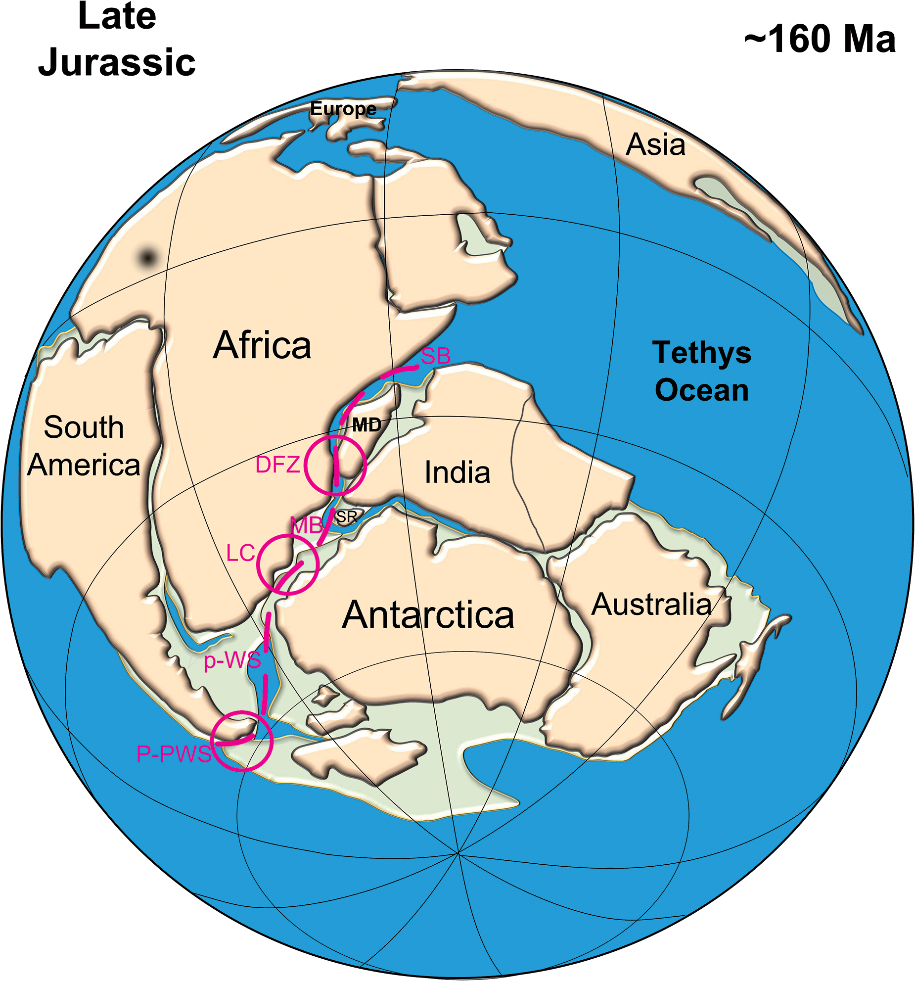
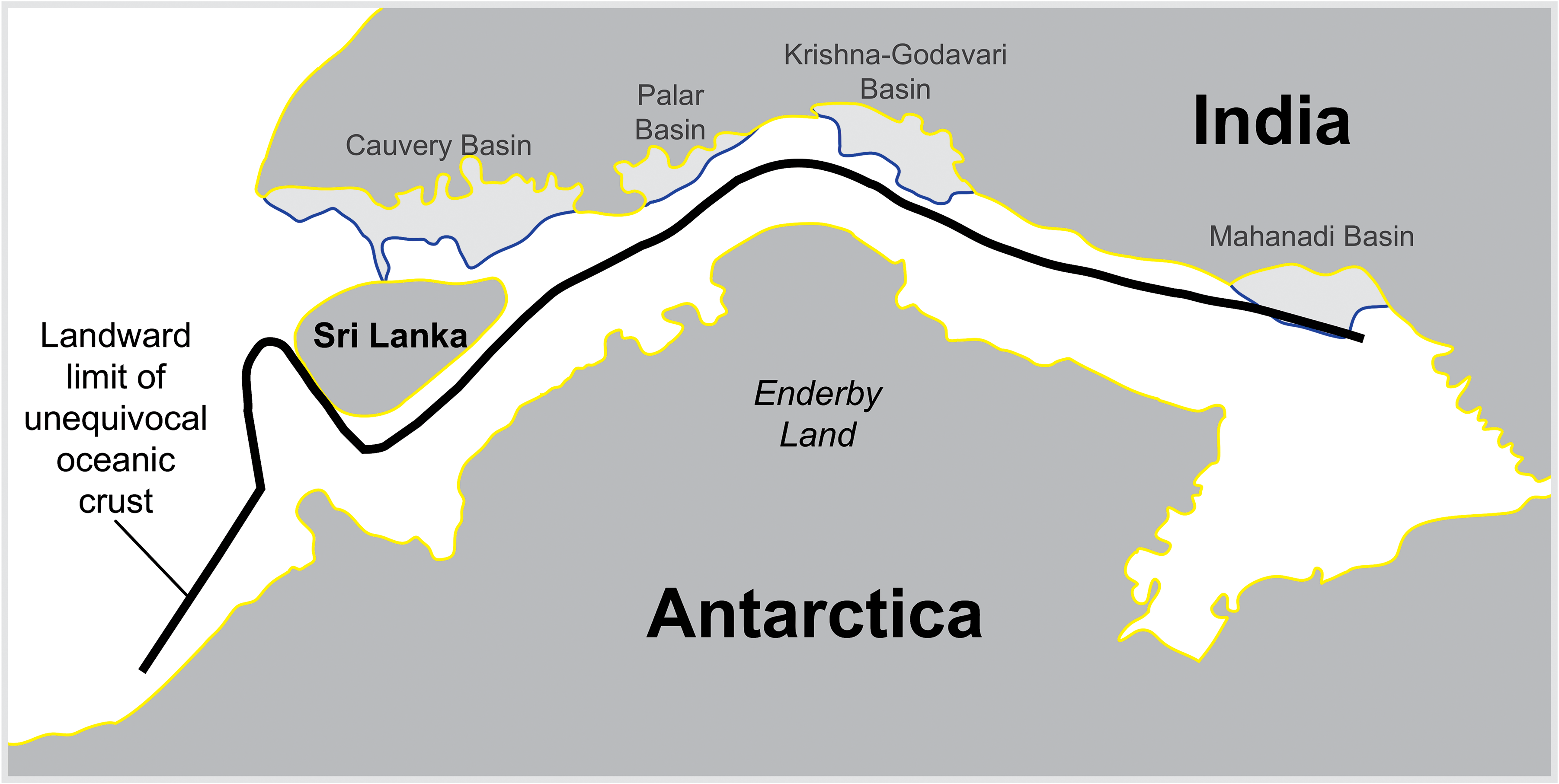
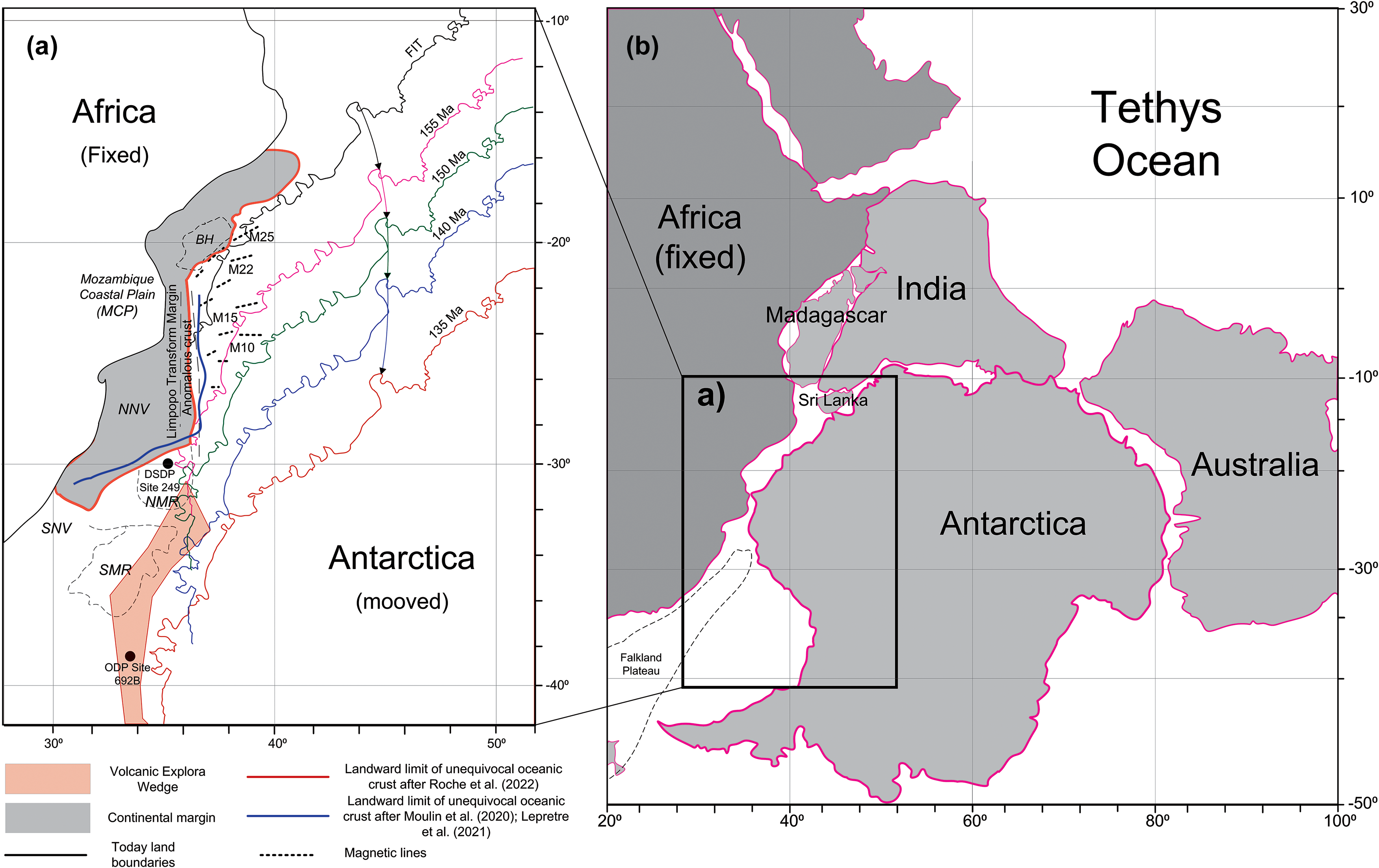
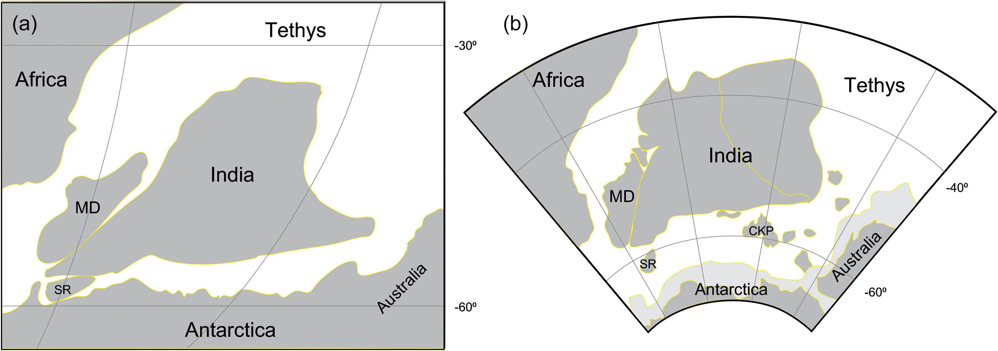
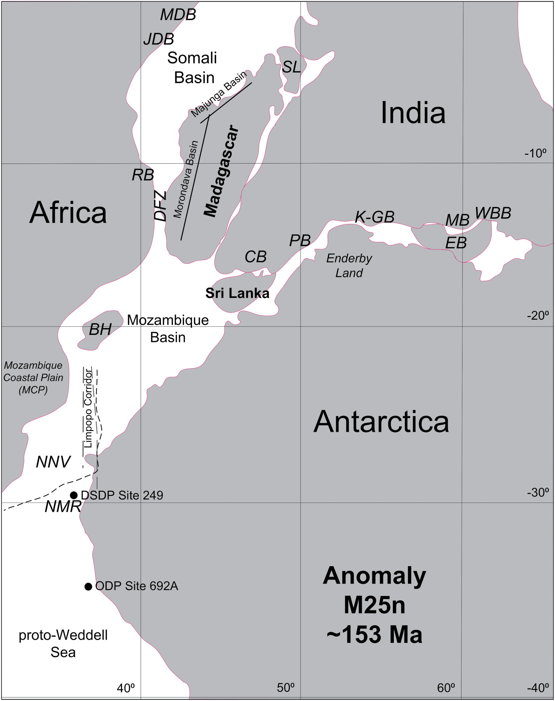
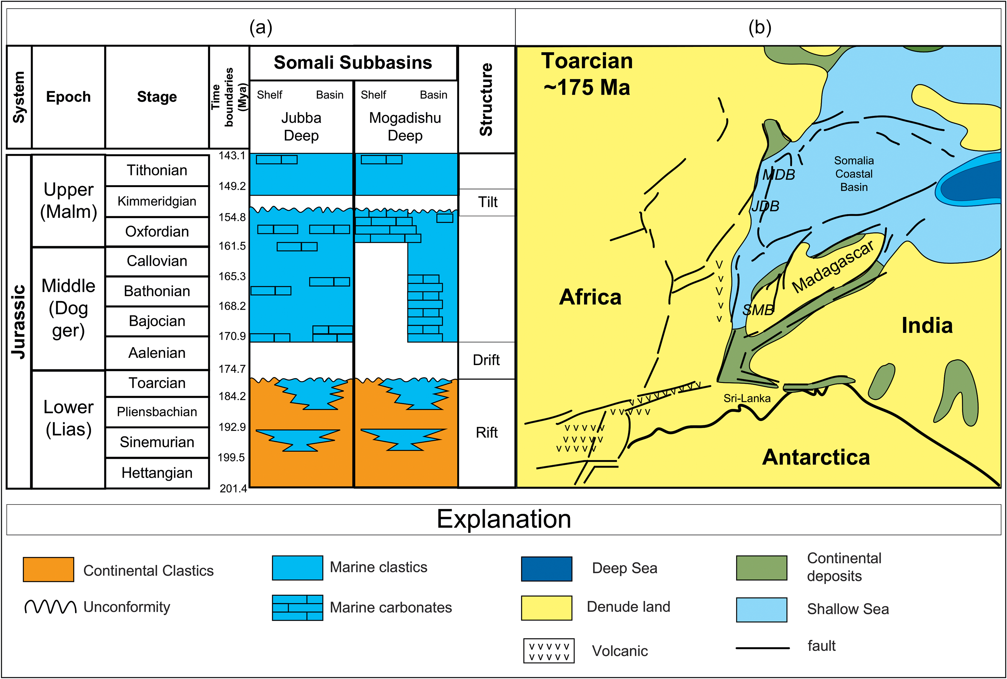
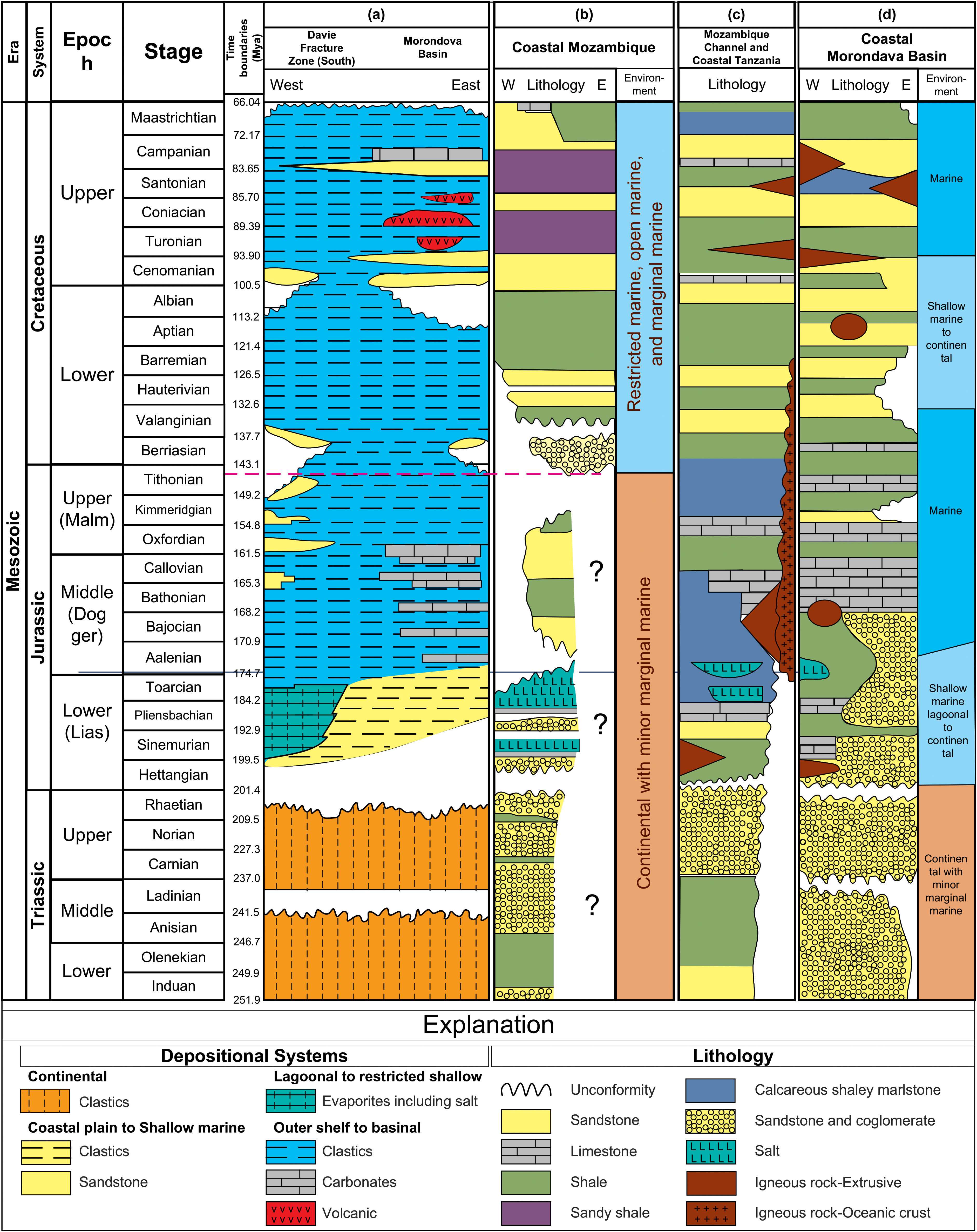
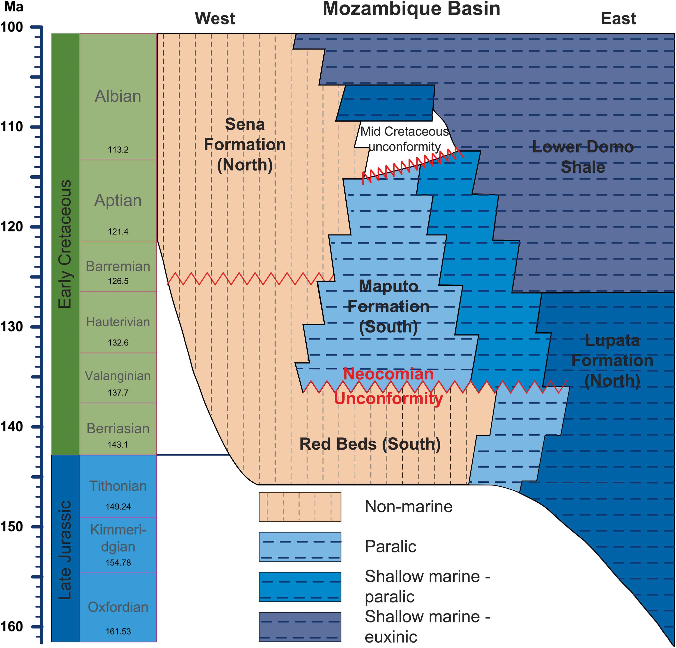
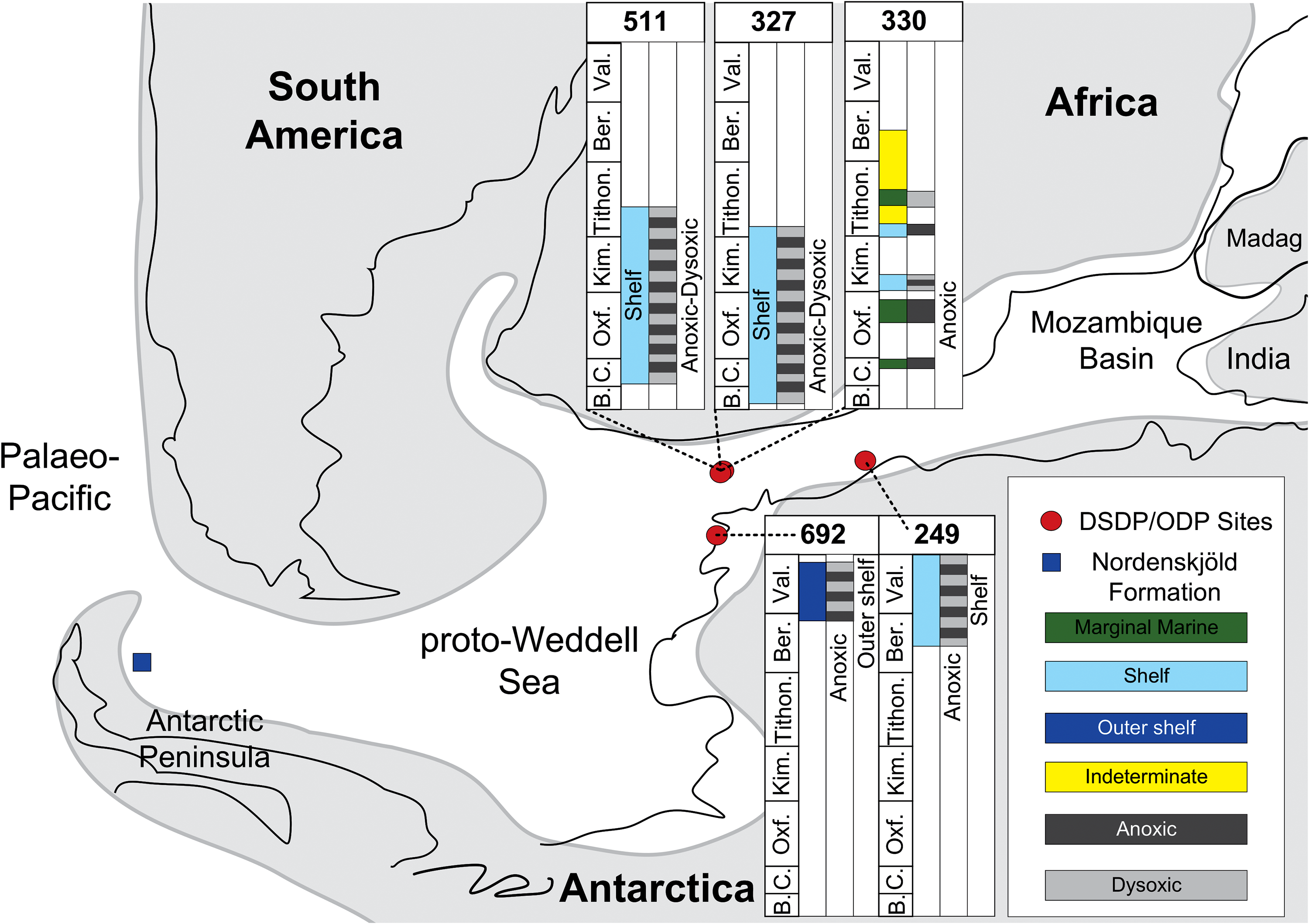
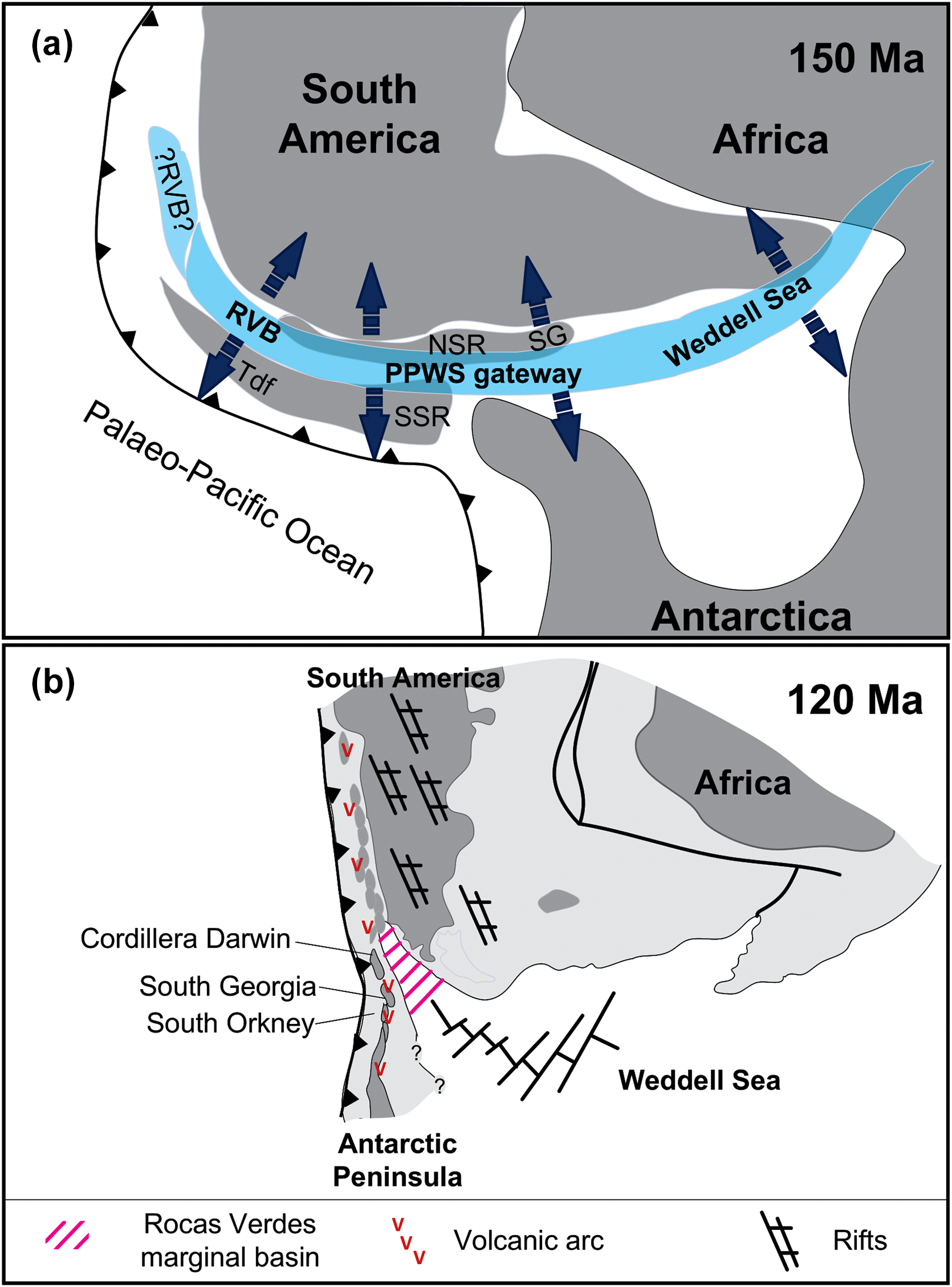
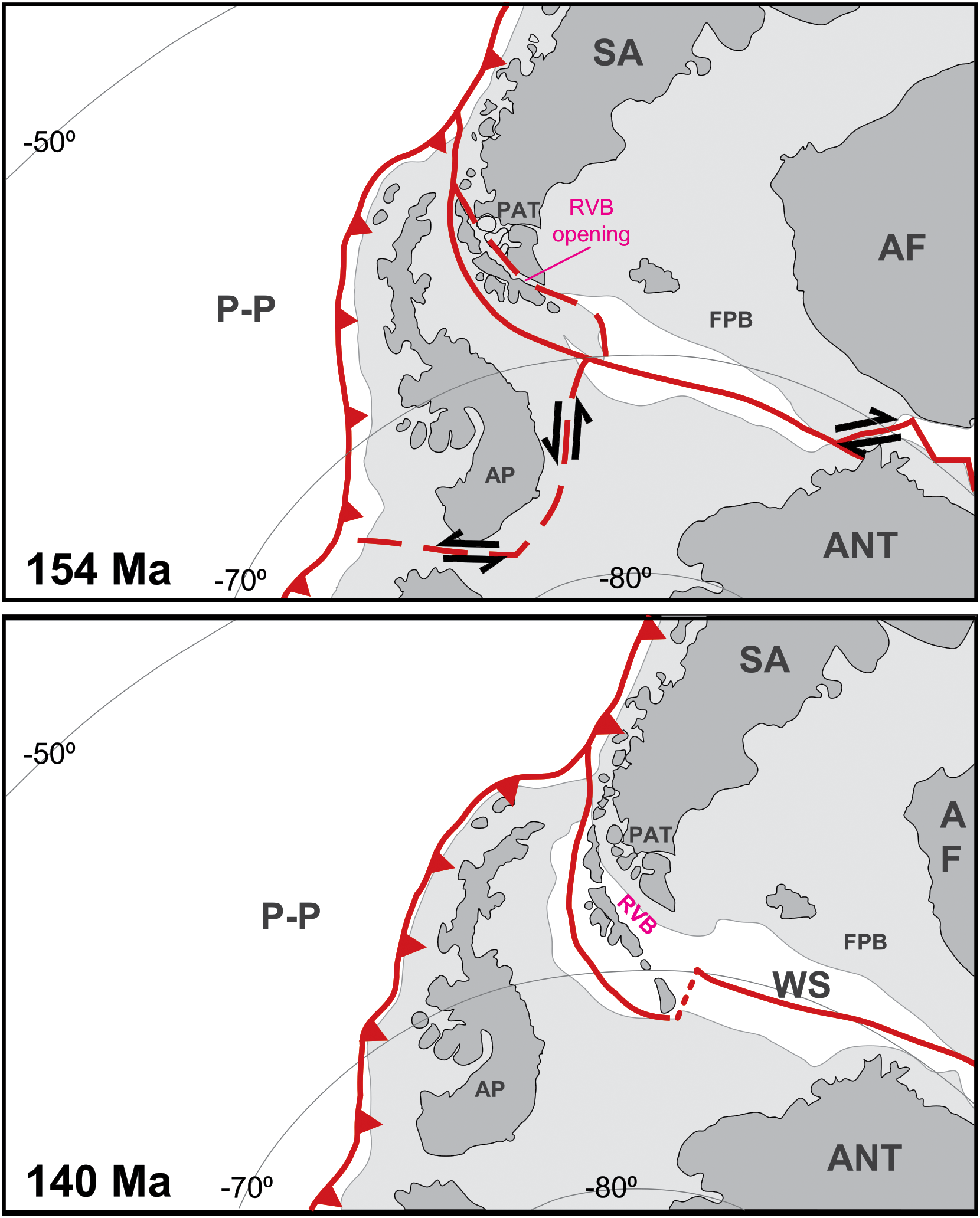
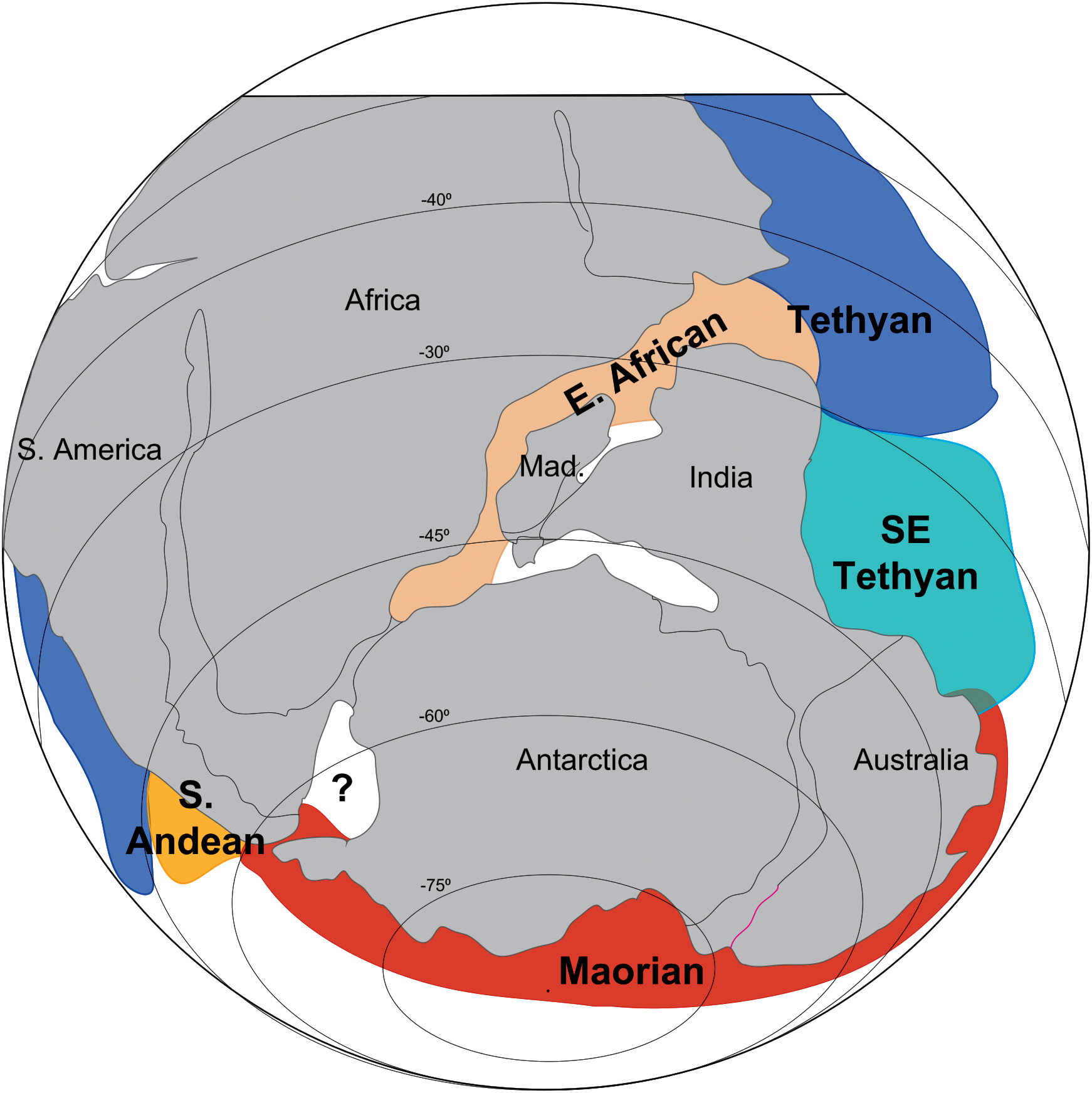
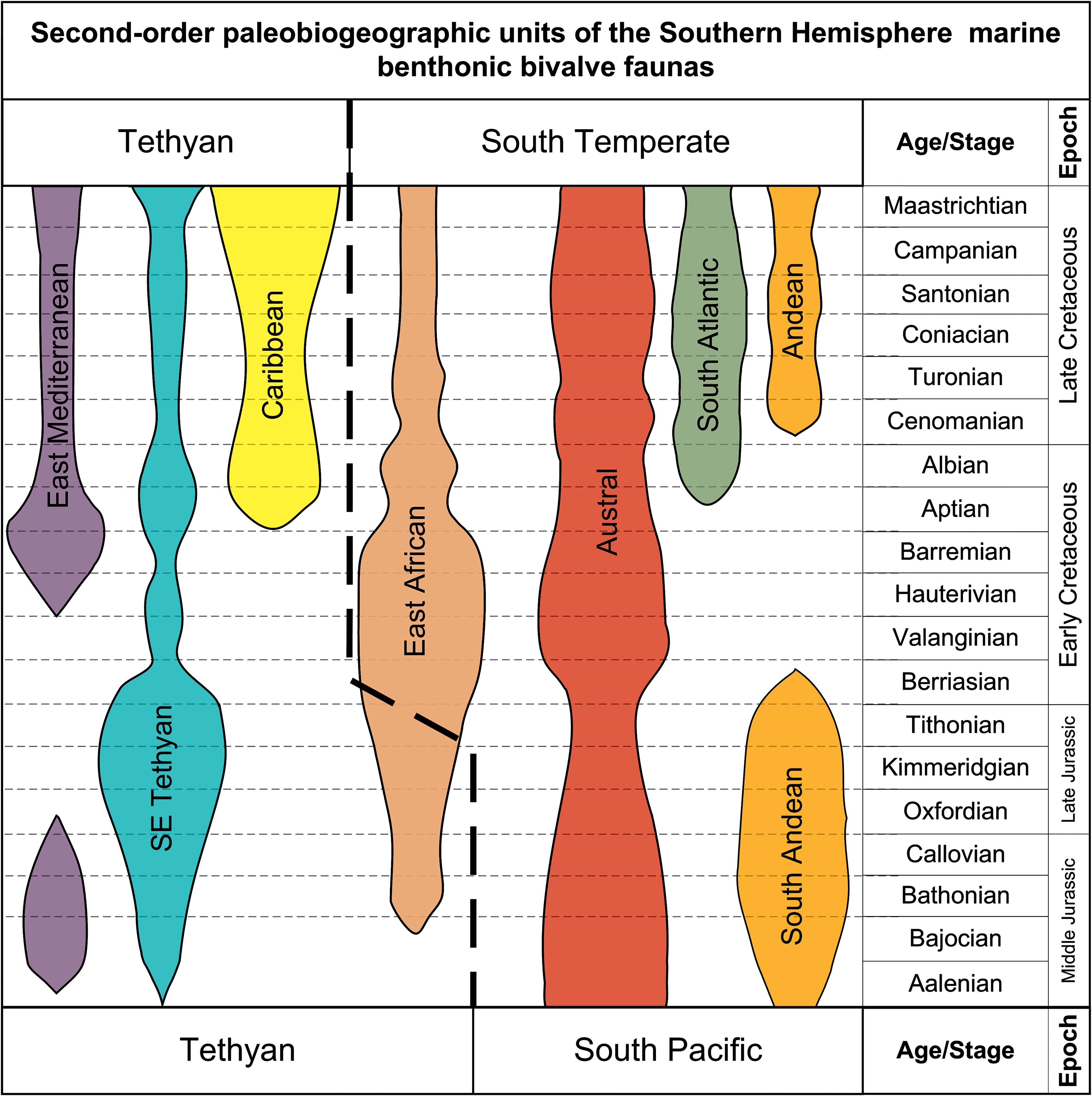
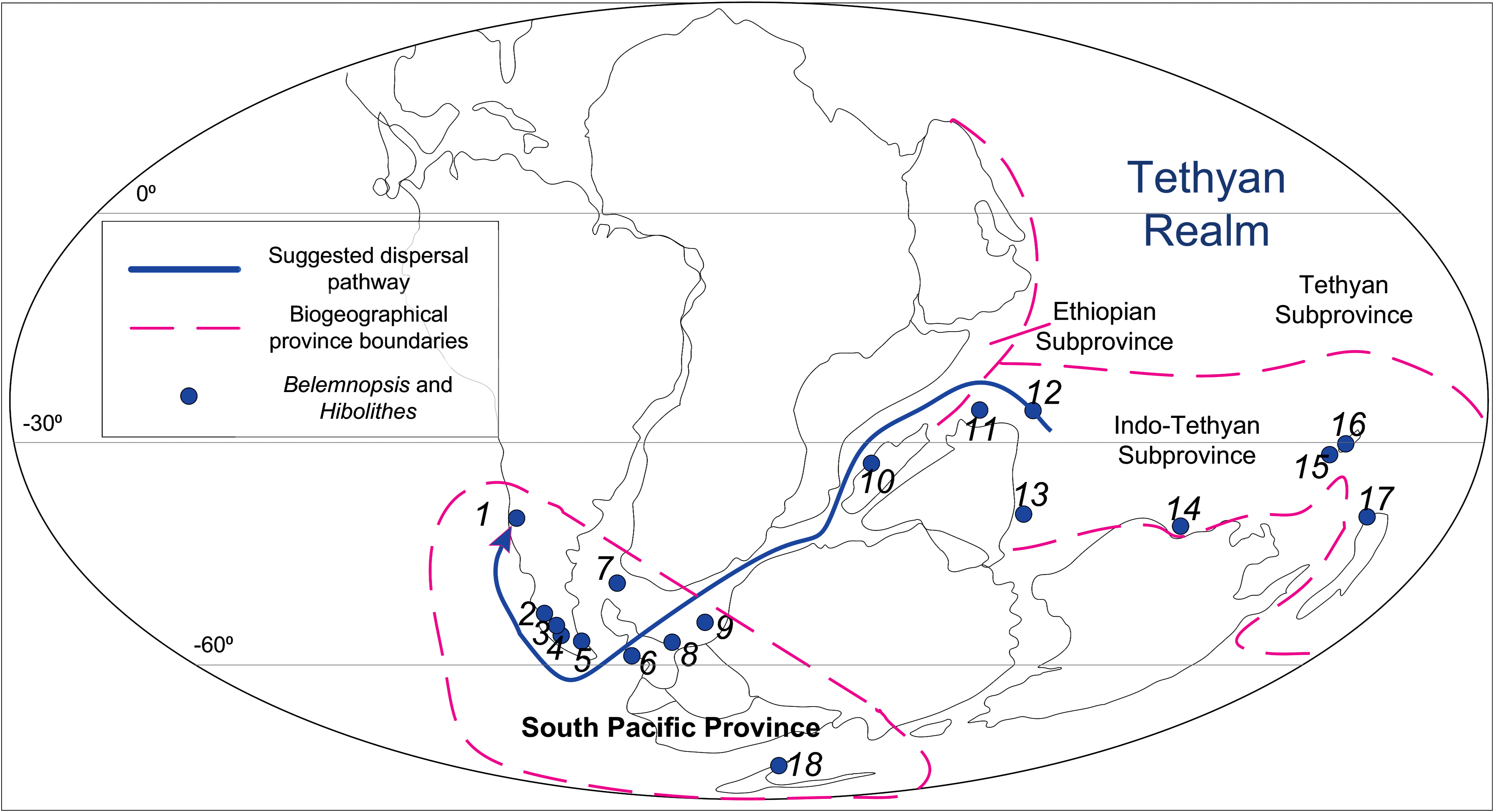
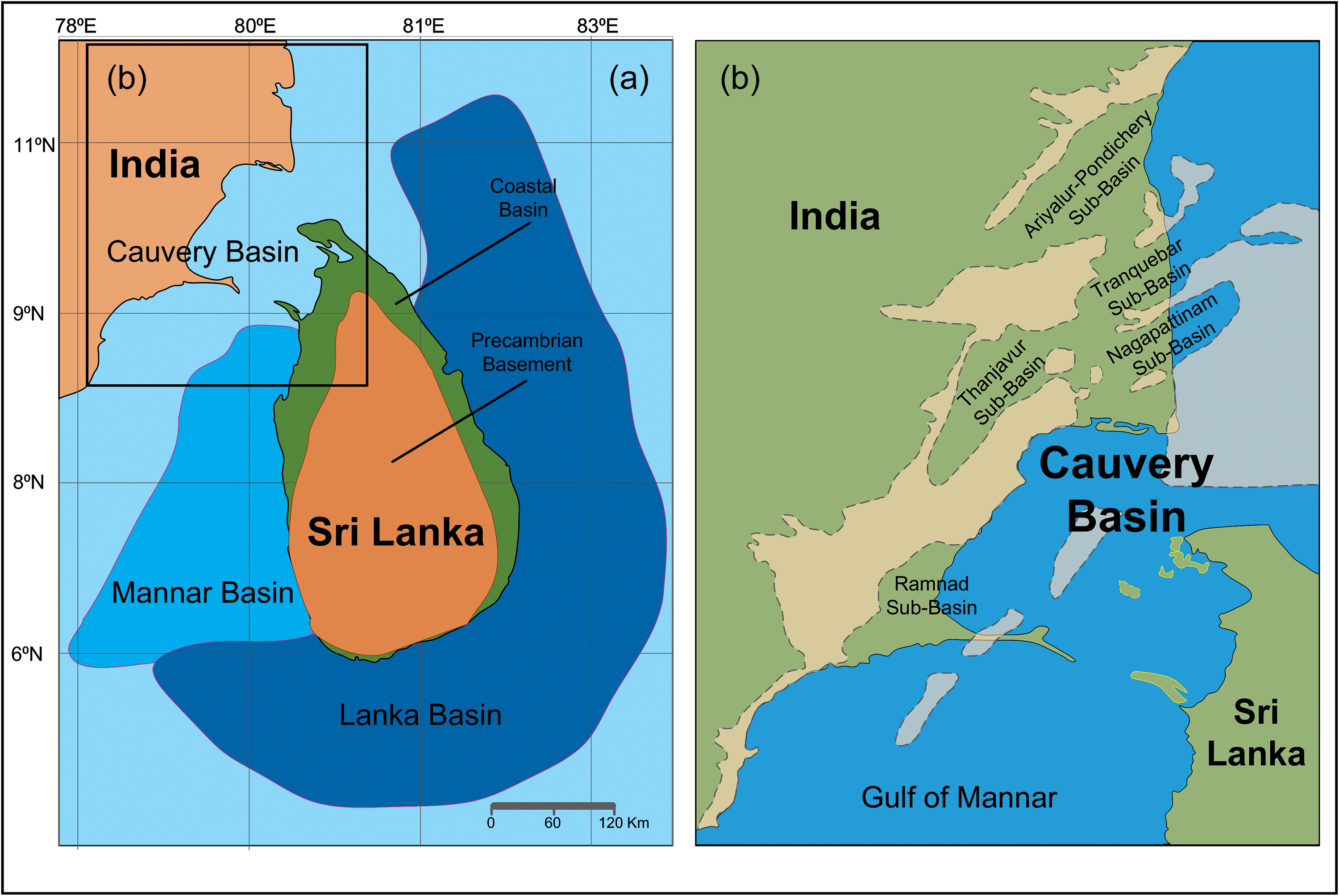
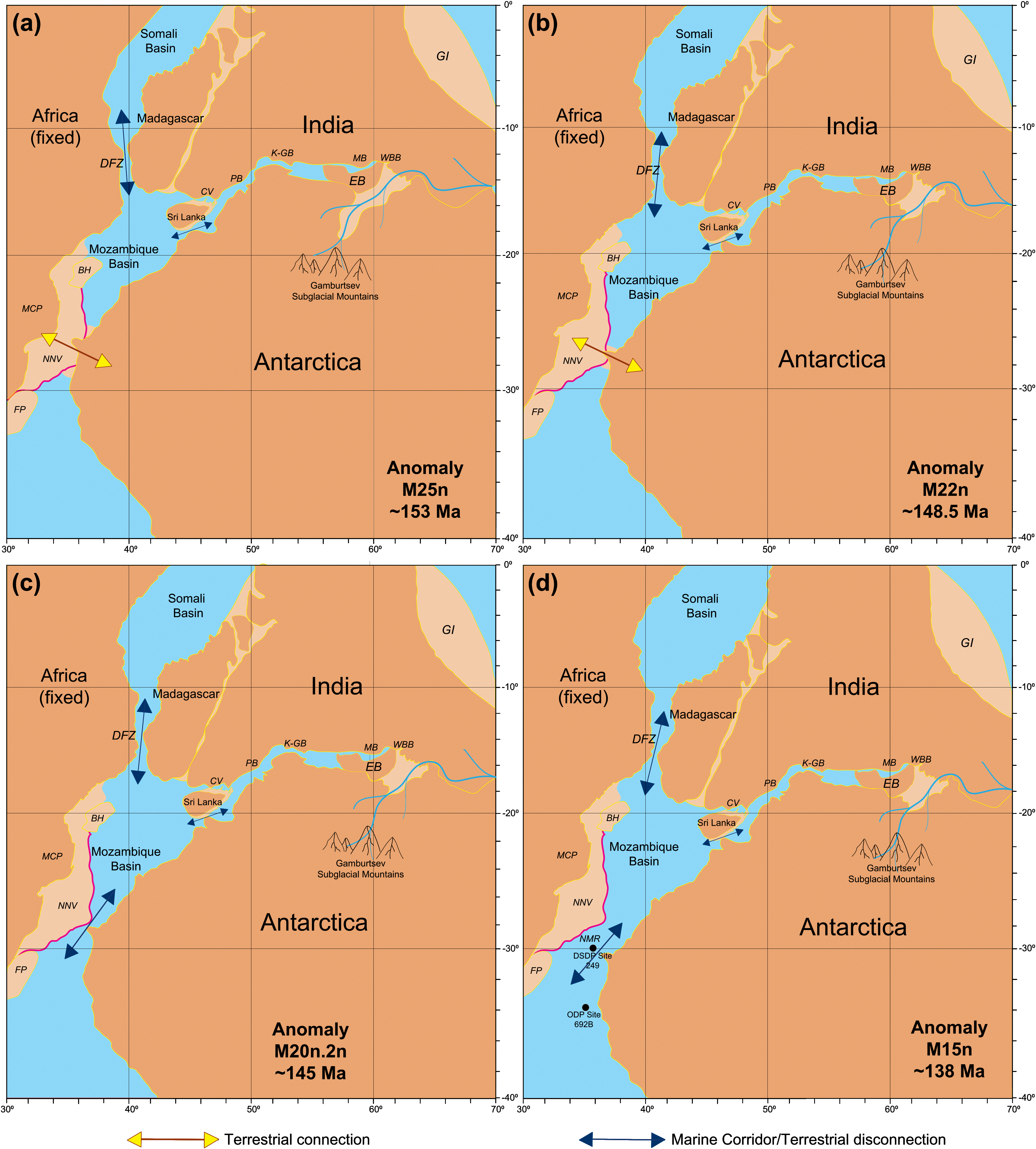
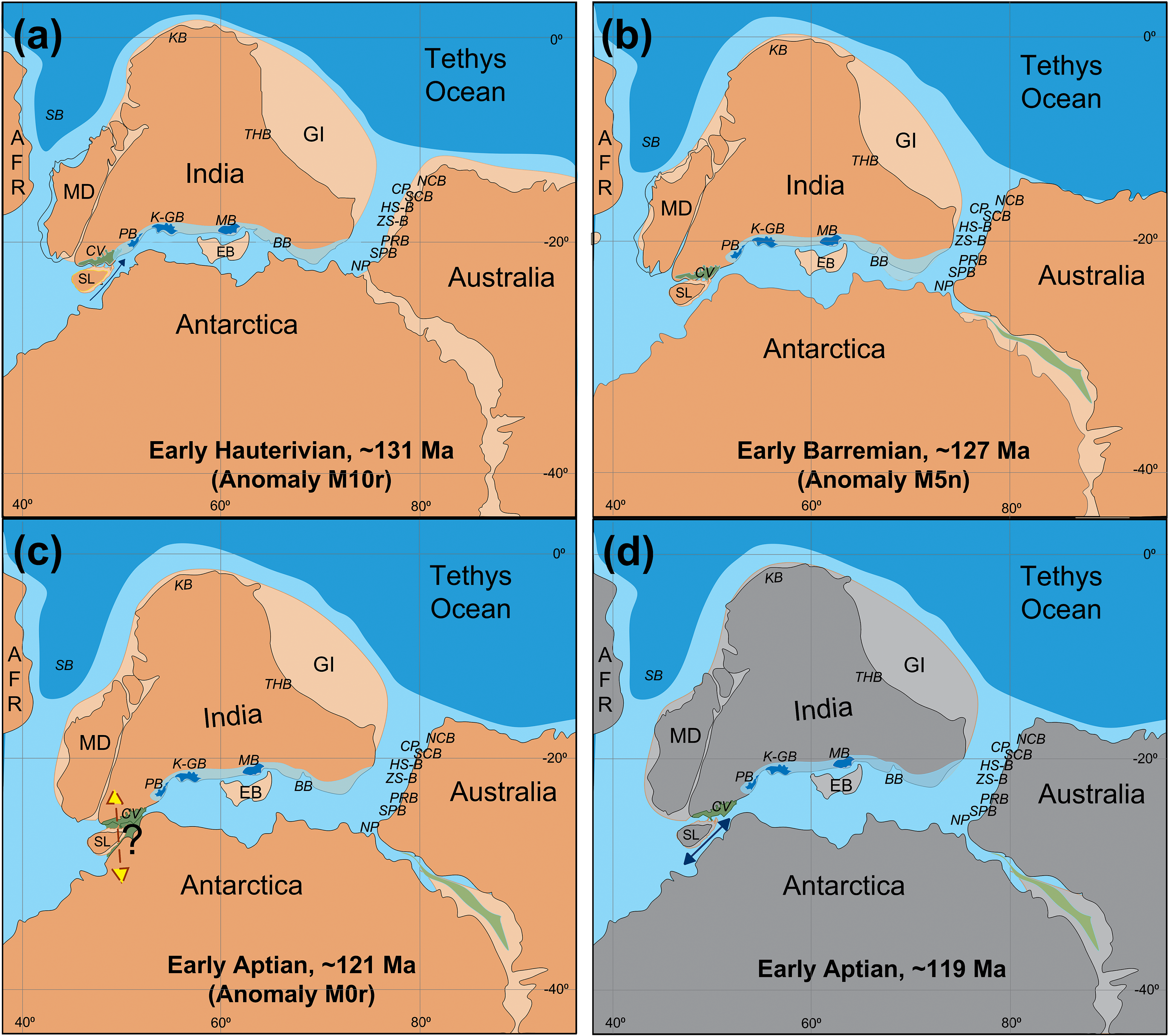
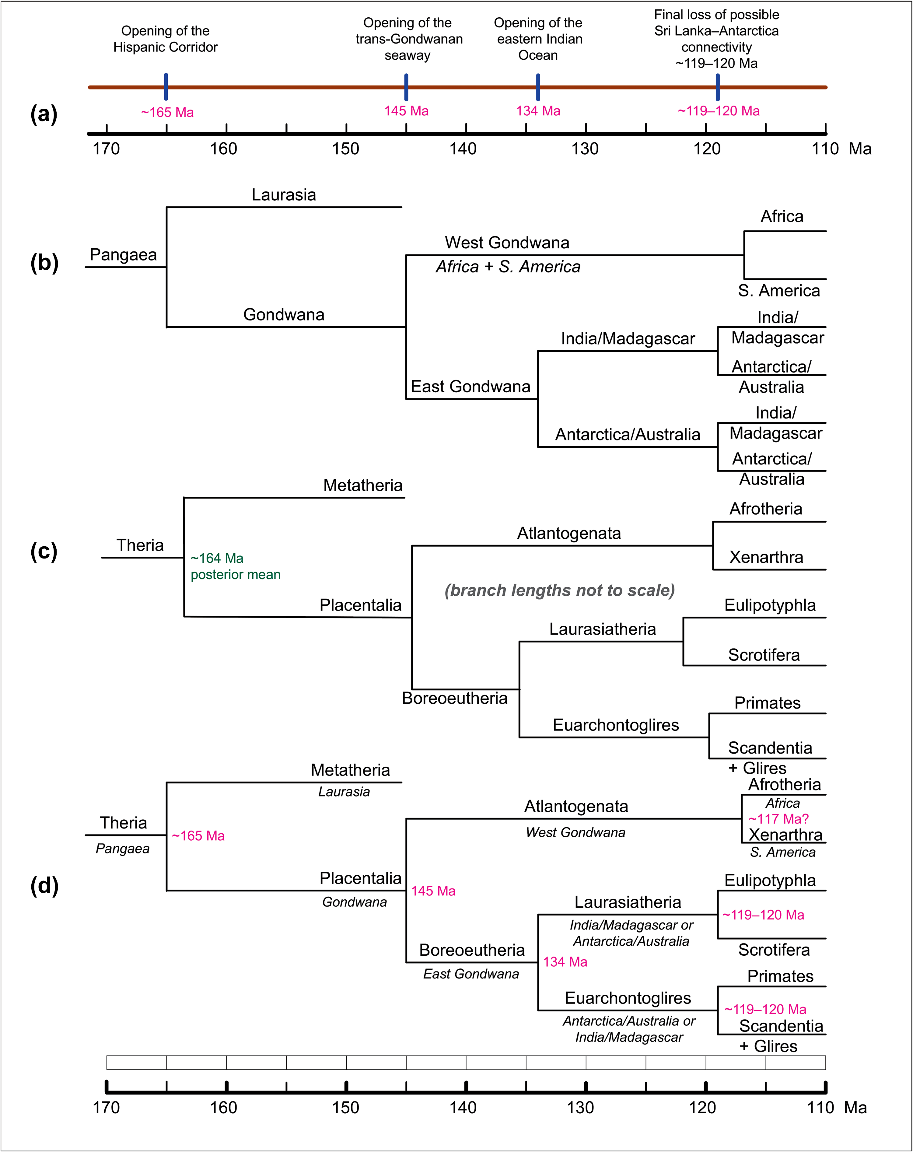


 Open access

