NORTH TYNESIDE
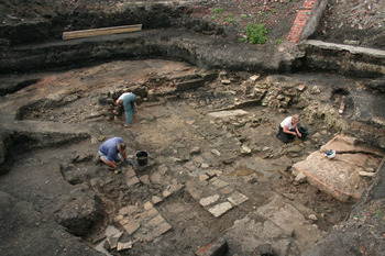
(1) Wallsend fort (Segedunum) (NZ 300 658): a community archaeology excavation located the fort baths, 120 m due south of the fort and close to the edge of the river Tyne (fig. 5). The remains were found at a depth of 3.5 m on the site of the recently demolished Ship in the Hole public house, Gainer's Terrace. The baths were seen by John Hodgson in 1814Footnote 49 and were known from his note and other antiquarian sources to be in the general vicinity, but the exact site had been lost until now. The remains are badly robbed, but up to five courses of masonry, infilled hypocausts with intact pillars, and the opus signinum lining of the cold plunge all survive. The preliminary fragment of the plan obtained has some affinities with the ‘standard’ Hadrianic Wall bath-house arrangement as seen, for example, at Chesters (and in the modern reconstructed baths at Wallsend, 80 m closer to the fort). However, the building appears to have been drastically rebuilt to a new plan, possibly as a result of landslip. More will be exposed in 2015.Footnote 50
Wallsend. The fort baths, view towards the north-west; in the foreground, the buttressed exterior east wall of the baths. Interior right: frigidarium, with underfloor drain and in foreground (under white hard hat) cement lining of cold plunge. Interior left: a heated room with hypocaust removed. In the distance, beyond north–south standing wall, an infilled hypocaust. (Photo: Tyne and Wear Archives and Museums)

SOUTH TYNESIDE
(1) South Shields fort (Arbeia) (NZ 365 679): excavation continued in the same area,Footnote 51 20 m south-west of the south angle of the extended supply-base fort, reaching the earliest phase of activity yet seen here. Preceding the construction of the ditches of the supply-base extension was the northern edge of a WSW–ENE running road. Immediately north of this a stone-lined channel (either a drain or an aqueduct) ran on a curvilinear course which veered away from the alignment of the road as it ran towards the east. It is not yet certain whether these structures originated before c. a.d. 160 or whether they are contemporary with the unextended stone fort of c. a.d. 160–205 (Fort Period 4). They were certainly in use in the latter period, for the road was in use and the stone channel was robbed and backfilled immediately prior to the digging of the ditches of the extended supply-base which brought this area within the vicinity of the fort defences for the first time (Period 5, a.d. 205–8). The stone channel must have served a major structure (a hypothesis might be baths situated some 70 m south of the Period 4 fort). The backfill of the stone channel produced a small finely carved stone female head wearing a mural crown, probably a tutela.
In the area opened last year immediately abutting the south angle of the visible fort, tumble from the collapsed fort wall was found to be lying in a large ditch, 8.6 m wide. This seems likely to be the same as Ditch H excavated at the south-west gate in 1985–6, which belonged to a re-fortification of early post-Roman date.Footnote 52
NEWCASTLE UPON TYNE
(1) Benwell fort (Condercum) (NZ 216 647): work continued in trenches in the grounds of Hadrian School, 170 m west of the fort (not 270 m as erroneously reported last year), in the area immediately behind Hadrian's Wall.Footnote 53 65 m south of the centre-line of the West Road (which overlies Hadrian's Wall here) and 21 m south of the south edge of the Roman Military Way (described last year), was the centre-line of the north Vallum mound, which survived as a shallow upstand of mixed yellow clay 6 m wide. The rock-cut north lip of the Vallum ditch was located 9 m from the south edge of the mound. This places the centre of the Vallum ditch at a distance of 80 m from the centre-line of the West Road, meaning that the Vallum runs 20 m closer to the Wall than currently shown on OS Maps, but approximately in the position reported in 1941.Footnote 54
NORTHUMBERLAND
(1) Albemarle Barracks, Wall Mile 15 (NZ 084 681): a trench placed 50 m west of that described last yearFootnote 55 again examined the Wall ditch immediately north of the Military Road (B6318). The Wall ditch was found on the same alignment as before, here 9 m wide. It could not be bottomed due to waterlogging. The southern face of the Wall ditch was found to consist of a very steep 0.50 m drop from the natural surface to a shallowly sloping shelf some 1.20 m wide, after which there was a break of slope to a steeper ‘V’-shaped profile. The purpose of this ‘step’ seems to have been to accentuate the appearance of a mound of material on the edge of the berm, consisting of blue-grey clay up to 300 mm thick, containing sandstone fragments. Elsewhere a mound in this position has been associated with obstacles on the berm,Footnote 56 but their presence at Albemarle could not be confirmed because the southern edge of the mound and the berm beyond lay beneath the modern road.Footnote 57
(2) Vindolanda (NY 769 663): the 2014 excavations explored three areas of the site: (a) the south-eastern quadrant of the fourth-century stone fort; (b) below the remains of the third-century extramural settlement; and (c) in the field to the north of the last version of the Stanegate road.
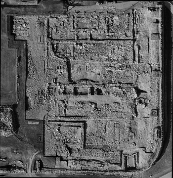
(a) A series of large late Roman barracks was uncovered inside the fourth-century fort (fig. 6) which were constructed on an east–west axis rather than the traditional north–south line which has been found elsewhere inside the fort in this period.Footnote 58 Although badly damaged by later building work which continued into the fifth and sixth centuries, and later stone-robbing, the barracks remained well-enough preserved to ascertain their basic alignment, size and room divisions. They consisted of three barracks with a fourth free-standing structure to their south completing the series. Each structure produced its own surprises during the excavations. Buildings 1 and 2 (excavated mainly in 2013) had a large number of arrowheads within and around them. A collection of material culture which included a silver brooch, gilded artefacts and a gold coin was also found. These expressions of wealth, rarely found from other parts of the fort and settlement in this period, highlighted the differences between those who had dwelt in the south-eastern quadrant barracks and those who lived in the smaller more contained houses/structures elsewhere at Vindolanda.
Vindolanda. Digitally corrected vertical photograph of the south-eastern quadrant of the latest stone fort. (Photo: Adam Stamford)

Lying above, and occasionally cut through the foundations of the barracks, were the remains of a number of superimposed large post-Roman buildings. These structures can be interpreted as representing the transition of Vindolanda from Roman to post-Roman, or Roman to British. This is a period which possibly extended occupation at the site for at least as long again as it was under Roman rule. Although relatively poorly preserved when compared to the barracks below, evidence for post-Roman buildings survived as post-pits, beam-slots and rubble foundations. A large stone apse was constructed facing to the south and into the western end of Building 2, its foundation remaining up to three courses high. Amongst all of the surviving buildings in this period was a well laid-out road network, not incomparable to the sophistication of the formal layout of the last Roman period. Post-Roman Vindolanda exhibits a structured and planned habitation pattern. Unfortunately, artefacts from post-Roman deposits were sparse. However, as with the copper-alloy strap-end of 2013 depicting a Christian with a shepherd's crook, the 2014 excavations produced a fine example of a similar figure carved into a stone discovered outside the south-eastern wall of Building 4.
(b) Below the foundations of the third-century vicus the excavations explored more of the anaerobic and oxygen-free organic deposits of the site which pre-date the construction of Hadrian's Wall.Footnote 59 Excavation conditions in these pre-Hadrianic levels were challenging and the work that took place was tightly confined by the existing framework of the third-century stone foundations of the vicus above. The levels under examination remained waterlogged for the duration of the work due to one of the wettest winters on record.
The remains of Vindolanda forts III–V (c. a.d. 100–140) survived in good enough condition to be able to ascertain the outlines of individual buildings, room-divisions and to rescue important material from their floors.
The landscape of pre-Roman Vindolanda was encountered below the Roman remains in this area. A sharply sloping hillside of natural boulder clay (from west to east) had been heavily disturbed by the Roman army's attempt to level the land for terraced platforms onto which they could build their new timber forts. A large number of artefacts came from these early deposits included 19 writing-tablets which consisted of a mixture of ink and stylus tablets with an unusual bias toward the stylus variety and a complementary collection of six stylus pens. Amongst the many hundreds of other artefacts were the remains of a cavalry sword, a cavalryman's spur and an example of a Roman wooden toilet seat. Over 130 leather boots and shoes also came from the excavations, including an important collection of children's shoes, slippers and a wooden bath clog.
(c) In the field to the north of the Stanegate road, the excavations continued in the same trench that was opened for investigation in 2013, extending it by 5 m to the north in order to explore the edge of what was suspected to be a kiln or industrial area in the 2013 season.Footnote 60 Excavation revealed that a very well-preserved kiln had been dug into the natural clay bank of the field. The kiln site had at least two major phases, firstly as a large square stone-built kiln and then secondly and intensively as a smaller clay-lined kiln to the south of the original structure.
It would seem that the initial purpose of the kiln was to produce brick and tile, presumably for use at Vindolanda itself and possibly for a pre-ordered construction job (such as a bath-house) rather than for a wider export market. None of the tiles or bricks carried a stamp, a usual feature of legionary tile works, again suggesting supply to a local market as there is less of a need to stamp a product that is not being exported. As the excavations continued in this area, it became clear that before this part of the site was abandoned there may have been quite a diverse range of production taking place, beyond its originally designed purpose. In addition to brick and tile, there were also a great number of ‘wasters’ from all manner of vessels, cups, storage jars, cooking pots and lids, some of which may have been copies of fine wares as well as coarse wares.