1. Introduction
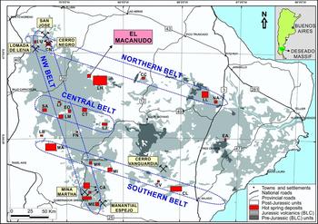
The El Macanudo hot spring deposit (Schalamuk et al. Reference Schalamuk, Zubia, Genini and Fernández1997, Reference Schalamuk, Guido, de Barrio, Fernandez and Stanley1999) is located in the Deseado Massif geological unit, Santa Cruz province, southern Patagonia, Argentina. This region is a 60,000 km2 area characterized by an extensive (> 30,000 km2), Middle to Late Jurassic, bimodal volcanic event known as the Bahía Laura Complex (BLC), including Chon Aike rhyolites intercalated with Bajo Pobre andesites, and reworked volcaniclastic rocks of the La Matilde Formation (Fig. 1; Echeveste et al. Reference Echeveste, Fernández, Bellieni, Tessone, Llambias, Schalamuk, Piccirillo and De Min2001; Guido, Reference Guido2004; Guido et al. Reference Guido, Escayola, de Barrio, Schalamuk and Franz2006). In broad terms, La Matilde strata, including fossil hot spring deposits, are found at the top of the sequence together with intermediate to silicic lava domes of the BLC, and accumulated in a mature (quiescent) phase of volcanism during Late Jurassic time (Guido, Reference Guido2004). Collectively, these rocks are part of the Chon Aike Silicic Large Igneous Province (SLIP), which extends from Argentine Patagonia to Antarctica (Pankhurst et al. Reference Pankhurst, Leat, Sruoga, Rapela, Marquez, Storey and Riley1998), and which developed in a diffuse extensional back-arc setting associated with the opening of the South Atlantic Ocean (cf. Richardson & Underhill, Reference Richardson and Underhill2002).
Simplified geological map of the Deseado Massif showing all 23 known hot spring localities (red boxes, with El Macanudo study area labelled) aligned in four major structural belts, and regional gold–silver epithermal mines (modified from Guido & Campbell, Reference Guido and Campbell2011). Inset shows the position of the Massif in Argentina. Abbreviations: LU – La Unión; CN – Cerro Negro; CC – Cerro Contreras; LL – La Leona; NA – Cañadón Nahuel; LH – La Herradura; EA – El Águila; SA – San Agustín; LF – La Flora; LM – La Marcelina; EO – Esperanza Oeste; CT – Cerro Tornillo; LJ – La Josefina; FN – Flecha Negra; LB – La Bajada; MA – La Marciana; MR – La María; MI – Monte Illiria; CV – Cerro Vanguardia; CL – Claudia; CA – Cerro 1 Abril; ME – Manantial Espejo.

Over a ~30 Ma interval in Middle to Late Jurassic time (c. 178–151 Ma), extension, magmatism and a high thermal gradient produced BLC volcanism and related hydrothermal mineralization in the Deseado Massif, including economic gold- and silver-bearing, mainly low-sulphidation-type epithermal quartz veins, and numerous hot spring occurrences (Fig. 1). The local and regional geological context of the numerous geothermal and significant epithermal deposits of the Deseado Massif, and their alignment along major lineaments as confirmed by aeromagnetic data, together indicate structural control of Jurassic hydrothermal activity, with the focus of dynamic fluid up-flow (cf. Renaut & Jones, Reference Renaut, Jones, Reitner and Thiel2011a) along the western and northern horst-like boundaries of the Massif itself (Guido & Schalamuk, Reference Guido, Schalamuk and Eliopoulos2003; Guido & Campbell, Reference Guido and Campbell2011).
Deseado Massif hot-spring-related deposits comprise mostly travertines, some siliceous sinters and plant-rich cherts, and are hosted in tuffs and reworked volcaniclastic sediments within fluvio-lacustrine settings over a 230×230 km area (Fig. 1; Guido & Campbell, Reference Guido and Campbell2011). A regional hydrothermal silicification event overprinted many of these interbedded hot spring and volcaniclastic rocks during Late Jurassic time (Guido et al. Reference Guido, Delupí, López, de Barrio and Schalamuk2002), indurating the deposits and thus generally increasing their long-term preservation potential. Nonetheless, depending on the extent of the silicification and local post-depositional history (i.e. diagenetic recrystallization, subsequent hydrothermal alteration), original textural and compositional details became obscured at a number of sites. For some deposits that underwent pervasive early silicification, hot-spring-related facies of exceptional preservation also can be found, such as the San Agustín sinter (SA of Fig. 1; Guido et al. Reference Guido, Channing, Campbell and Zamuner2010; Channing et al. Reference Channing, Zamuner, Edwards and Guido2011; García Massini et al. Reference García Massini, Channing, Guido and Zamuner2012), the Cerro Negro travertine (CN of Fig. 1; Guido & Campbell, Reference Guido and Campbell2012) and the Claudia sinter and travertine (CL of Fig. 1; Guido & Campbell Reference Guido and Campbell2014).
The Jurassic Patagonian rocks subsequently were buried by Cretaceous and Cenozoic continental and marine passive margin successions (Giacosa et al. Reference Giacosa, Zubia, Sánchez and Allard2010), and then unearthed with minimal structural disturbance to expose intact, erosional windows into 23 mapped subaerial and/or sub-lacustrine geothermal systems (Guido & Campbell, Reference Guido and Campbell2011). At several locations, the fossil palaeo-surface expressions of hydrothermal activity are recorded, with diverse geothermal landscapes represented. Such three-dimensional spatial associations of these fossil geothermal facies assemblages enable detailed palaeogeographic, palaeoenvironmental and palaeohydrologic reconstructions (e.g. Guido & Campbell, Reference Guido and Campbell2009, Reference Guido and Campbell2012, Reference Guido and Campbell2014; Guido et al. Reference Guido, Channing, Campbell and Zamuner2010; Campbell et al. Reference Campbell, Guido, Gautret, Foucher, Ramboz and Westall2015a). They also provide glimpses into the inner workings of entire volcanic–epithermal–geothermal systems rarely possible in other older or younger continental hydrothermal settings elsewhere in the world.
The aim of this study is to evaluate in detail the geological context and diverse facies associations of the hot-spring-related deposits at El Macanudo, which are exposed over a 1 km2 area and may be divided into northern and southern portions. The northern part (here designated Macanudo Norte) was one of the first supposed sinter occurrences noted in the Deseado Massif (Schalamuk et al. Reference Schalamuk, Zubia, Genini and Fernández1997). It later was reinterpreted as a travertine deposit mostly replaced by silica (Schalamuk et al. Reference Schalamuk, Guido, de Barrio, Fernandez and Stanley1999), which is a type of pseudosinter (cf. Guido & Campbell, Reference Guido and Campbell2012), in its higher topographic levels. Neither the northern nor southern (Macanudo Sur) areas of this palaeo-geothermal field have been described in detail. This Upper Jurassic hot spring deposit exhibits surface geothermal manifestations comparable to Pleistocene–Recent, geothermally affiliated deposits of Yellowstone National Park (Wyoming, USA), the Kenyan Rift Valley and elsewhere. Overall, the El Macanudo fossil geothermal system yields textural details of variable quality, owing to both the differential preservation potential of particular subaerial versus subaqueous facies, as well as to the timing and extent of carbonate diagenesis, silica replacement and the newly identified, late-stage hydrothermal (acid) alteration in some areas. Hence, El Macanudo provides an opportunity to assess the impact of depositional and post-depositional history on hot spring (micro)facies and microbial fossil preservation in hot spring travertines, thereby yielding clues to the processes affecting the development and long-term preservation potential of Lagerstätte (‘mother lode’ deposits of exceptional fossil preservation) in epithermal settings and, more broadly, in extreme environments of the geological record.
2. Thermal spring fluids and facies
Continental hot spring deposits of high-enthalpy hydrothermal systems develop as chemical precipitates derived from thermal waters discharging at the Earth's surface, typically in the temperature range of ~35–100°C, and located in fluvio-lacustrine settings of active tectonic and volcanic terrains near plate boundaries (Renaut & Jones, Reference Renaut, Jones, Riding and Awramik2000, Reference Renaut, Jones, Reitner and Thiel2011a). The fluids originate as mainly meteoric waters, in places supplanted with minor connate, magmatic or metamorphic components, which convectively circulate above magmatic intrusions, and by conductive heat transfer through the shallow crust, via faults, fractures and permeable horizons (Henley & Ellis, Reference Henley and Ellis1983; Renaut & Jones, Reference Renaut, Jones, Reitner and Thiel2011a). Heated fluids rise and may boil at subterranean levels with decreasing pressure towards the surface, causing steam separation that results in surface discharges of hot springs and geysers (liquid-dominated) or fumaroles and steaming ground (steam-dominated) (Henley & Ellis, Reference Henley and Ellis1983; Renaut & Jones, Reference Renaut, Jones, Reitner and Thiel2011a). The mineralogy of the precipitates accumulating in association with the surface hot spring manifestations, as well as the biota that inhabit areas of thermal discharge, are fundamentally controlled by water composition (Jones & Renaut, Reference Jones, Renaut, Reitner and Thiel2011). Hence, geothermal fluids are generally classified into chloride, sulphate and bicarbonate waters by dominant anion (Henley & Ellis, Reference Henley and Ellis1983; Nicholson, Reference Nicholson1993; Renaut & Jones, Reference Renaut, Jones, Reitner and Thiel2011a), although mixed anionic composition types are also known (e.g. acid–sulphate–chloride; Ellis & Wilson, Reference Ellis and Wilson1961). Alkali chloride geothermal fields are derived from chemical interactions of hot water with volcanogenic host rocks to a few kilometres crustal depth, creating solute-rich, saline geothermal reservoirs (up to 400°C), with magmatically driven fluid circulation enabling migration to the surface of these deep, chloride-rich fluids, where they are expelled as clear, near-neutral pH hot springs and geysers over-saturated in silica and which, upon cooling and evaporation, precipitate relatively thick (decimetres to tens of metres) siliceous sinter (Fournier & Rowe, Reference Fournier and Rowe1966; Fournier, Reference Fournier1985; Renaut & Jones, Reference Renaut, Jones, Reitner and Thiel2011a,b). The rising thermal fluids may move laterally through permeable, near-surface units and mix with shallow groundwater, particularly around the margins of up-flow zones, to produce acid–sulphate springs as common geothermal manifestations (Henley & Ellis, Reference Henley and Ellis1983; Renaut & Jones, Reference Renaut, Jones, Reitner and Thiel2011a). In particular, oxidation of H2S and other gases in steam-heated, oxygenated groundwater may exit to the surface in the vapour phase as acidic fumaroles and steaming ground, or condense in perched water tables to form acid–sulphate springs and acid lakes that are often associated with deposits of silica residue, native sulphur and hydrothermal alteration minerals (e.g. kaolinite, jarosite, alunite) (e.g. Rodgers et al. Reference Rodgers, Browne, Buddle, Cook, Greatrex, Hampton, Herdianita, Holland, Lynne, Martin, Newton, Pastars, Sannazarro and Teece2004; Renaut & Jones, Reference Renaut, Jones, Reitner and Thiel2011a). In some locations, mixing of acid–sulphate and chloride waters will deposit thin siliceous sinters (a few centimetres thick) with distinctive textures and biotas (Schinteie, Campbell & Browne, Reference Schinteie, Campbell and Browne2007). Furthermore, concentration of dissolved CO2 in groundwater around the peripheries of geothermal fields and at sites distant from volcanic activity may generate neutral to alkaline bicarbonate springs of variable temperature, and form subaerial travertine mounds and terraces of variable thickness (a few centimetres to tens of metres) via loss of CO2 from the discharging fluids at atmospheric pressure (Pentecost, Reference Pentecost2005; Renaut & Jones, Reference Renaut, Jones, Reitner and Thiel2011a). Subaqueous (lacustrine) hot springs also form travertine with distinctive cone geometries (e.g. Guido & Campbell, Reference Guido and Campbell2012). In areas of low topographic relief and limited potential for lateral flow of fluids near the land surface, both acid and alkaline springs may form in close proximity (e.g. Renaut & Jones, Reference Renaut, Jones, Reitner and Thiel2011a; Jones & Renaut, Reference Jones and Renaut2012). Overall, the thickness and extent of the sinter or travertine deposits developed in geothermal areas are mainly controlled by volume and duration of fluid flow as well as by the degree of over-saturation of fluids in silica and bicarbonate species with respect to ambient temperature (Henley & Ellis, Reference Henley and Ellis1983; Guido & Campbell, Reference Guido and Campbell2014). These are, in turn, influenced by tectonics (e.g. faults as baffles and/or barriers to fluid flow, reactivation), volcanism (e.g. water table elevation, heat source), host rock geology (e.g. dissolved mineral concentration, permeability) and climate (e.g. fluid volume, water table fluctuations) (e.g. Sibson, Reference Sibson1987; Sturchio, Dunkley & Smith, Reference Sturchio, Dunkley and Smith1993; Rowland & Simmons, Reference Rowland and Simmons2012; Guido & Campbell, Reference Guido and Campbell2014; Sillitoe, Reference Sillitoe2015).
Calcareous terrestrial hot spring deposits, or thermogene travertines, are porous, laminated carbonates that precipitate from mineral-laden thermal waters, with both abiogenic and biogenic influences on their deposition (Pentecost, Reference Pentecost1990, Reference Pentecost2005; Koban & Schweigert, Reference Koban and Schweigert1993; Guo & Riding, Reference Guo and Riding1994). Thermogene travertines are distinguished from the more common meteogene travertines by the origin of their dissolved CO2, which is derived from deep, high-enthalpy fluid reservoirs in the former setting, and from the soil and atmosphere in the latter (Pentecost, Reference Pentecost1993; Gibert et al. Reference Gibert, Taberner, Sáez, Giralt, Alonso, Edwards and Pueyo2009). Thus, as used here, thermogene refers to the fluid source rather than necessarily the surface temperature of the spring, which for travertines can vary widely (Pentecost, Reference Pentecost2005). For example, across the western USA, travertine-depositing springs range from 5 to 95°C, with most between 10 and 30°C (Chafetz & Folk, Reference Chafetz and Folk1984). In essence, thermogene travertines are produced by inorganic CaCO3 precipitation owing to degassing and evaporation of the debouching thermal spring waters, although microbial surface catalysis (templating) may also stimulate carbonate precipitation (Pentecost, Reference Pentecost1990; Guo & Riding, Reference Guo and Riding1994; Chafetz & Guidry, Reference Chafetz and Guidry1999). In contrast, tufa tower, cone and mound-like deposits (a type of meteogene travertine) generally differ from hot spring travertines by a lack of terraces, a predominance of moulds of higher aquatic plants, formation under relatively cooler (e.g. groundwater seepage) conditions in normal freshwater environments and their often greater geographic extent (e.g. within and around margins of shallow lakes) (e.g. Koban & Schweigert, Reference Koban and Schweigert1993; Rosen, Arehart & Lico, Reference Rosen, Arehart and Lico2004; Pentecost, Reference Pentecost2005). In practice, however, it is difficult to apply current classifications of tufa versus travertine to (sub)fossil systems where water is no longer flowing, and the distinction between these two terms has been blurred owing to inconsistent usage (Pentecost, Reference Pentecost2005; Jones & Renaut, Reference Jones, Renaut, Alonso-Zarza and Tanner2010).
Cooling and evaporation of discharging thermal fluids around subaerial hot spring vent and mound sites cause precipitation of hydrous, non-crystalline opal-A in the case of alkali chloride sinter formation (White, Reference White1967; Jones & Renaut, Reference Jones and Renaut2003a,b; Jones, Renaut & Owen, Reference Jones, Renaut and Owen2011) and aragonite and calcite precipitation in the case of thermogene travertine deposition (Pentecost, Reference Pentecost1990, Reference Pentecost2005; Fouke et al. Reference Fouke, Farmer, Des Marais, Pratt, Sturchio, Burns and Discipulo2000). This often rapid mineralization may coat and entomb the available biotic and abiotic surfaces; thus, the preservation potential of physical, chemical and biological signatures in sinters and travertines make them valuable archives of the environmental, geothermal and geological processes operating during periods of hot spring activity (e.g. Sturchio, Dunkley & Smith, Reference Sturchio, Dunkley and Smith1993; Cady & Farmer, Reference Cady, Farmer, Bock and Goode1996; Farmer, Reference Farmer2000; Fouke et al. Reference Fouke, Farmer, Des Marais, Pratt, Sturchio, Burns and Discipulo2000; Lynne et al. Reference Lynne, Campbell, Moore and Browne2005, Reference Lynne, Campbell, Moore and Browne2008; Handley & Campbell, Reference Handley, Campbell, Tewari and Seckbach2011; Lynne, Reference Lynne2012; Campbell et al. Reference Campbell, Guido, Gautret, Foucher, Ramboz and Westall2015a, b).
Sinter and travertine facies models (Guido & Campbell, Reference Guido and Campbell2011, their fig. 3, p. 40) correlate distinct macro- and microscopic mineral textures to positions upon the cooling discharge apron (~100°C to ambient) (Cady & Farmer, Reference Cady, Farmer, Bock and Goode1996; Farmer, Reference Farmer2000; Fouke et al. Reference Fouke, Farmer, Des Marais, Pratt, Sturchio, Burns and Discipulo2000; Campbell et al. Reference Campbell, Sannazzaro, Rodgers, Herdianita and Browne2001; Guido & Campbell, Reference Guido and Campbell2011; Lynne, Reference Lynne2012). Subaerial sinter and travertine facies assemblages may be broadly grouped into three main categories: (1) vent mound or spring-vent pool and proximal slope (> 65°C), (2) mid-apron terraces (< 65–45°C) and (3) distal apron to marsh (< 45°C) (Guido & Campbell, Reference Guido and Campbell2011). Biotic community composition and distributions follow temperature and fluid chemistry gradients down the discharge apron, which show broad similarities between alkali chloride and bicarbonate springs, but also exhibit some distinct differences, manifesting in somewhat variable sedimentary textures between the two spring types (e.g. Guido & Campbell, Reference Guido and Campbell2011, their table 1, p. 40). With respect to post-depositional modification of ancient hot spring deposits, siliceous sinters naturally undergo a series of silica mineral phase transformations as structural water is lost during diagenesis (i.e. change from non-crystalline opal-A to microcrystalline quartz over time; Herdianita et al. Reference Herdianita, Browne, Rodgers and Campbell2000; Lynne & Campbell, Reference Lynne and Campbell2003; Lynne et al. Reference Lynne, Campbell, Perry, Browne and Moore2006, Reference Lynne, Campbell, James, Browne and Moore2007). Moreover, travertine carbonate is quite sensitive to recrystallization such that diagenesis may be rapid and readily destroy environmentally indicative fabrics (e.g. Renaut, Morley & Jones, Reference Renaut, Morley, Jones, Renaut and Ashley2002; Jones & Renaut, Reference Jones, Renaut, Alonso-Zarza and Tanner2010; Guido & Campbell, Reference Guido and Campbell2011, Reference Guido and Campbell2012). Early diagenetic silicification, common in volcanic terrains and occurring in both sinter- and travertine-forming settings, may facilitate cases of exceptional preservation of biotic and abiotic fabrics of (palaeo)environmental significance (e.g. Trewin, Fayers & Kelman, Reference Trewin, Fayers and Kelman2003; Guido et al. Reference Guido, Channing, Campbell and Zamuner2010; Guido & Campbell, Reference Guido and Campbell2012).
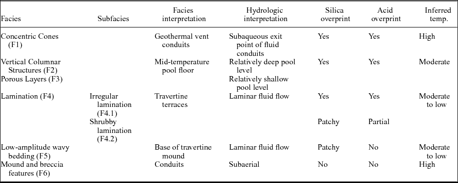
Palaeoenvironmental and palaeohydrologic interpretation of the six described thermogene travertine facies (F1–F6) at El Macanudo, Deseado Massif, Patagonia, Argentina

3. Materials and methods
Field mapping aided by satellite imagery was conducted in Santa Cruz province, Patagonia, Argentina, in August 2012, and rock samples were cut and photographed in the School of Environment at the University of Auckland. Twenty-nine representative thin-sections (2×4 cm dimensions, 30 μm thick) were made from about 50 rock samples and viewed under plane and polarized light microscopy. Energy dispersive X-ray spectroscopy (EDS/EDAX) was undertaken at the Research Centre for Surface and Materials Science, University of Auckland, with a Si–Li (lithium-drifted) EDS detector on a FEI Quanta 200 F operating at 25 kV to obtain semi-quantitative compositional data for selected surfaces.
4. Results
4.a. Geology of the El Macanudo area
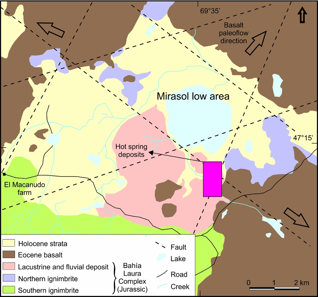
The geology of the El Macanudo area (Fig. 2) is represented by Jurassic volcanic rocks of the Bahía Laura Complex (BLC, Feruglio, Reference Feruglio1949; Guido, Reference Guido2004) that are partially covered by Eocene basaltic flows and Holocene alluvial–colluvial deposits. The El Macanudo hot spring deposit is situated at the southeastern edge of a 7×3 km, NW-elongated low area where Mirasol Lake is located (designated Mirasol low area in Fig. 2). It is delineated by NW- and NNE-trending faults, creating a four-sided geometric area, and is covered by Eocene flood basalts on three of the four sides. There also are ENE-trending lineaments in the study area (Fig. 2).
Geological map of the El Macanudo – El Mirasol area (modified from Schalamuk et al. Reference Schalamuk, Guido, de Barrio, Fernandez and Stanley1999). Magenta rectangle indicates the hot spring area, shown in more detail in Figure 3. Basalt palaeoflow direction indicators suggest the present-day Mirasol low area was an early Cenozoic topographic high, a possible (now eroded) volcanic centre (discussed further in the text).

The Late Jurassic volcanic rocks include two types of ignimbrites as well as volcanic reworked materials (Schalamuk et al. Reference Schalamuk, Guido, de Barrio, Fernandez and Stanley1999). Volcanic reworked deposits occupy a ~4 km2 area and comprise ash fall tuffs intercalated with lacustrine and fluvial deposits assigned to the La Matilde Formation. The El Macanudo hot spring deposits are interbedded with this unit along its eastern outcrop area, which is spatially related to a major NE-trending fault that constrains the Mirasol low area to the east (Fig. 2). The hot springs are associated with laterally pervasive, silicified tuffaceous and lacustrine strata, and intense argillic alteration in the unsilicified tuffs and volcaniclastic rocks.
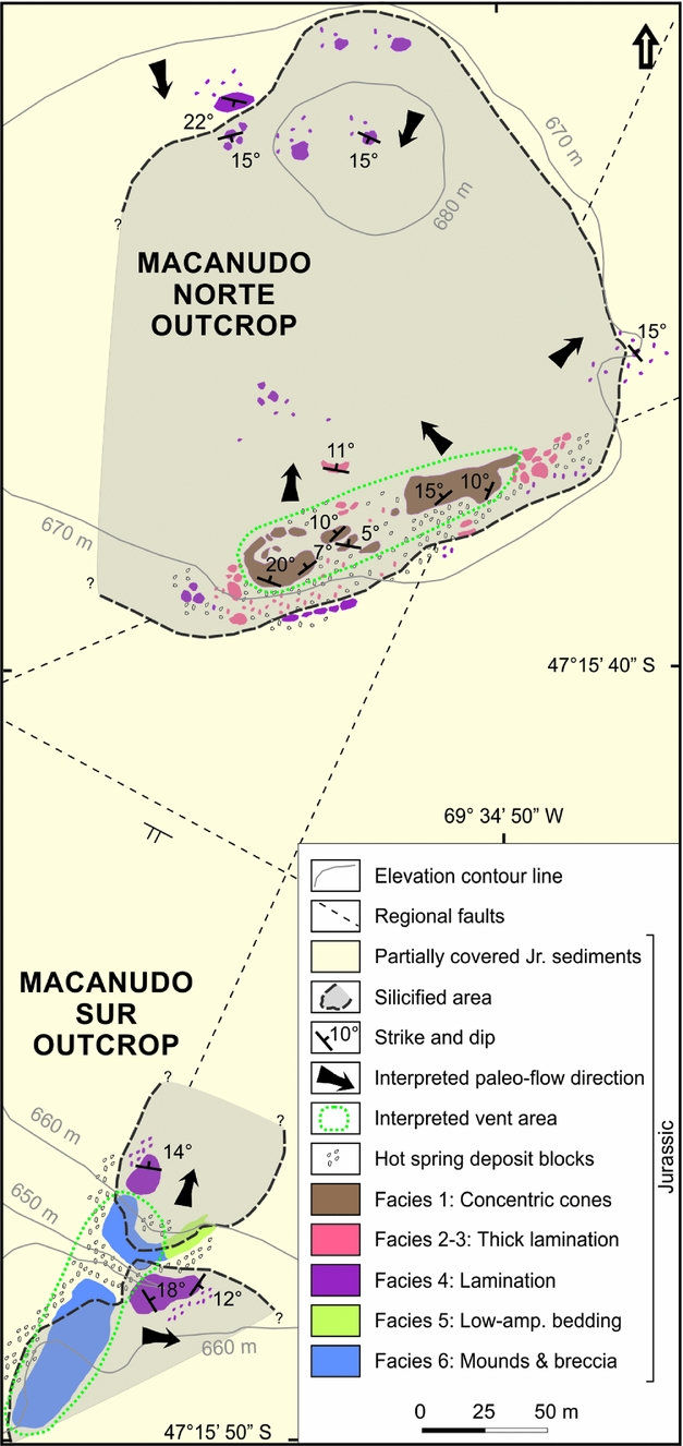
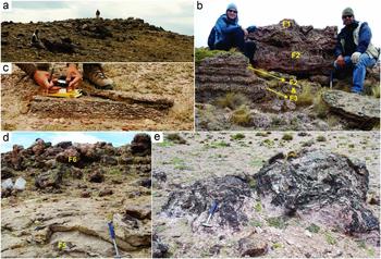
Two outcrops expose the hot spring deposits, separated by a NW-trending normal fault (Fig. 3). The Macanudo Norte Outcrop, previously described as the Macanudo Hill outcrop (Schalamuk et al. Reference Schalamuk, Zubia, Genini and Fernández1997, Reference Schalamuk, Guido, de Barrio, Fernandez and Stanley1999), constitutes silicified travertine hot spring facies above 670 m altitude (Fig. 4a). The Macanudo Sur Outcrop is composed of carbonate and siliceous hot spring deposits that occur at a lower altitude (650–660 m). These two hot spring outcrops were mapped and studied in detail to define six sedimentary facies related to surface geothermal activity (Table 1). The Macanudo Norte Outcrop contains four spring-related facies. Specifically, large concentrically layered cones up to 1 m high (F1 of Fig. 4b) are underlain by irregularly alternating, thickly laminated horizons (centimetres to a few decimetres thick) of vertical columnar structures (F2) and porous layers (F3) (Fig. 4b). The F1–F3 facies are surrounded by a laminated facies (F4) that is tabular in outcrop (Fig. 4c). The Macanudo Sur area exhibits the same laminated facies (F4) found at Macanudo Norte, along with two additional facies: low-amplitude wavy bedding (F5) overlain by mounds and breccias (F6) (Fig. 4d, e). A detailed description of these six hot-spring-related facies follows.
Detailed geological and facies map for the El Macanudo hot springs area, which includes six hot-spring-related sedimentary facies (F1–F6) variably preserved as travertine or silicified travertine (pseudosinter). The Macanudo Norte Outcrop is exposed at approximately the 670 m elevation contour; whereas, the Macanudo Sur Outcrop is at approximately 660–650 m elevation.

Photographic overview of the El Macanudo hot spring area and its six different facies types, F1–F6. (a) Macanudo Norte Outcrop; view to the top of the 670 m contour hill. (b) F1 to F3 horizons cropping out at Macanudo Norte: concentric cones (F1), and vertical columnar structures (centimetre- to decimetre-scale) (F2) alternating with porous structures (F3). Note the different heights of the vertical columnar horizons (F2), which are likely related to palaeo-hot spring water depth. (c) Subcrop of the laminated facies (F4) at Macanudo Norte. (d) Macanudo Sur outcrops of low-amplitude wavy bedding (F5), in close spatial association with silicified mounds (F6). (e) Macanudo Sur Outcrop of travertine mound (F6) comprising irregularly and concentrically layered stromatolitic features. Hammer for scale is 40 cm long.

4.b. El Macanudo hot spring facies
4.b.1. Facies 1 (F1): concentric cones
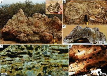
This siliceous facies is exclusively located at the Macanudo Norte Outcrop (Fig. 3). It is positioned at the highest part of the outcrop, along the southern border, and occurs as a 125×30 m ridge aligned with a regional ENE-trending fault. This is the most morphologically distinctive facies at El Macanudo, and therefore attracted the attention of Schalamuk et al. (Reference Schalamuk, Zubia, Genini and Fernández1997, Reference Schalamuk, Guido, de Barrio, Fernandez and Stanley1999) in an initial survey of the area. The concentrically laminated cones are composed of individual or groups of pipe-shaped to conical, stromatolitic vertical structures, preserved in their original environmental position (Figs 4b, 5a–c). They are composed of thin (< 1 cm), wavy to crenulated, concentric bands arranged in cylindrical to ovoidal forms in transverse section (Fig. 5b). Individual concentric cones range in diameter from centimetres to < 1 m, and in height up to 1 m, and commonly occur in groups as mounded features (Fig. 5a). The concentric cones display strong porosity in hand sample (Fig. 5c), preserved normally as elongated holes mainly parallel to the stromatolitic lamination, with their upward terminations (where unbroken) exhibiting cone-shaped tips (Fig. 5a, inset). In thin-section, irregularly rounded pores to elongate holes are clearly evident, with some cross-cutting laminae but most others extending parallel to the lamination (Fig. 5d). The pores are oriented along and between the thin stromatolitic walls, and display concave internal borders, many of which are coated by a thin reddish layer (Fig. 5d). The matrix is silicified and recrystallized from the original carbonate, and chalcedonic spheres and quartz crystals are observed under the microscope. In only a few places is the original carbonate texture preserved, where it encloses remnants of poorly preserved organic matter and/or microbes (Fig. 5e).
Photographs and photomicrographs of the concentric cone facies (F1) at the Macanudo Norte Outcrop. (a) Vertical views of a group of coalescent concentric cones, and a detail of an upper cone termination (inset). (b) Detail of two eroded, laterally linked concentric cones in plan view, with preserved stromatolitic fabric. (c) Cut slab of a concentric cone (vertical section view) showing typical high porosity of the rock, patchy silicification (grey) and oxidation (red Fe-staining). (d) Thin-section of a concentric cone in transverse section, showing pervasive, randomly oriented but dense, irregular pores (black, open spaces) and oxidation (red tint) following stromatolitic lamination (white, quartzose, slightly undulatory horizons). (e) Detail of a patchy remnant of silicified travertine in thin-section, with possible preserved microbial fabric including faint wavy laminae (thin arrows), and possible amygdaloidal bubble, now filled with clear quartz, from inferred photosynthetic degassing of a microbial mat (thick arrow). The surrounding area of the thin-section (not shown) is very poorly preserved, with no discernible primary fabric. Hammer for scale is 35 cm long.

4.b.2. Alternations of Facies 2 (F2): vertical columnar structures; and Facies 3 (F3): porous layers
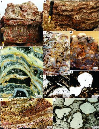
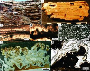
These two facies commonly occur together as horizontal intercalations of silica-rich layers (thick laminae to thinly bedded) underneath and/or distributed around the concentric cones (F1) facies (Figs 4b, 6a, b). The F2 facies is characterized by thickly laminated, siliceous columns of different heights (1–25 cm) and variable quality of preservation. These vertical elements are, in places, thin and wrinkly to wavy (Fig. 6a, b), columnar (Fig. 6c) or botryoidal (Fig. 6d), and form circular features as observed in plan view.
Photographs and photomicrographs of intercalated F2 and F3, vertical columnar structures and porous layers, respectively, at the Macanudo Norte Outcrop. All vertical section views. (a) Detail of the largest vertical columnar structures (F2) found in outcrop, in relation to interbedded F1 and F3 horizons. (b) Outcrop view (vertical section) of F2 and F3 intercalations. (c) Detail of the vertical columnar structures (F2). (d) Detail of the botryoidal variant of the vertical structures (F2). (e) Thin-section of the vertical columnar structures showing two types of voids: (1) inferred bubbles with almond shapes (b, partially or completely filled by translucent quartz) trapped within the growing stromatolite laminae, likely from microbial photosynthetic (oxygen) degassing (type 1, syn-depositional, concordant with laminae); and (2) etched voids (v, black, empty void space with irregular boundaries), formed by inferred acidic condensate corrosion and dissolution (type 2, post-depositional, discordant with laminae). (f) Void type 1 (b, inferred bubble), an amygdaloidal (almond-shaped) hollow filled with quartz, and broken at upper concave portion, likely due to fluid pressure. (g) Void type 2, an irregularly rounded hole (void space). (h) Hand sample of a porous layer (F3), with detail of lamination remnants. (i) Detail of dense, type 2 voids, typified by irregular margins and oxidation (red Fe-stained) rims, characterizing the porous layers (F3).

The microtextures of these vertical columnar F2 structures have oriented rounded holes (Fig 6e), with a recrystallized matrix that contains some chalcedony spheres, preserved patches of the original microbial fabrics and scattered plant fragments. Two generations of holes can be distinguished (Fig. 6e). Elongated to lenticular, fingernail-shaped holes are common, which are yellowish to reddish in colour in their concave internal portions (labelled b in Fig. 6e; Fig. 6f). In places, the walls are broken (Fig. 6f) and the once hollow interiors completely or partially filled by quartz crystals. In addition, circular to irregular holes are present, with an internal, thin, reddish coating (labelled v in Fig. 6e, g). The F3 facies is mainly composed of very porous massive to stratified silica layer(s) (Fig. 6h). Irregular holes are homogenously distributed (i.e. not oriented) and internally show the same reddish coating (Fig. 6i). The matrix mainly consists of quartz crystals with a mosaic texture, with some patchy remnants of the original microbial fabric, plant debris and a few chalcedony spheres.
4.b.3. Facies 4 (F4): lamination
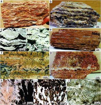
A large area of layered silicified carbonate with ~1 cm thick laminae constitutes this facies. The lamination is distributed around the F1 to F3 outcrop area (Fig. 3) at the Macanudo Norte Outcrop. This facies is also found in the higher parts of the Macanudo Sur Outcrop. Several morphological varieties are included in this facies, which show a gradation in alteration and diagenesis. Most of them superficially appear to be siliceous sinter; hence, the term ‘pseudosinter’ (cf. Guido & Campbell, Reference Guido and Campbell2011) can be applied to this lithofacies (Figs 4c, 7a). Two main end-members were defined: an irregular lamination type (F4.1) occurring adjacent to the F1 to F3 facies distribution area, and a shrubby lamination type (F4.2) found in a geographically more extensive area, especially to the north, and which exhibits excellent preservation at one location (Fig. 4c).
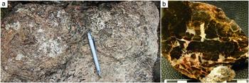
Photographs and photomicrographs of the lamination facies (F4) at Macanudo Norte Outcrop. All vertical section views. (a) Hand sample of travertine showing silica replacement, defined as pseudosinter by Guido & Campbell (Reference Guido and Campbell2011). (b) Hand sample of irregular lamination (Facies 4.1), where white clay-rich and black silica-rich horizons can be distinguished; white horizons are inferred as products of late-stage hydrothermal alteration (e.g. acid–sulphate steam condensate infiltration). (c) Detail of F4.1, illustrating wavy laminated stromatolitic texture. (d) Detail of F4.1, illustrating the cracks sealed with silica in the clay-rich layers (black arrow) and a type 2 void (white arrow). (e, f) Hand sample slab and thin-section images of shrubby lamination (Facies 4.2), where thin (up to 0.5 cm high), ‘bushy’ dendritic stromatolites are evident. (g) Hand sample of an inferred acid-overprinted F4.2 example, showing strong development of secondary porosity (type 2 voids) (cf. Fig. 6). (h) Detail of shrubs of F4.2, some silicified (light coloured, left) and others (dark coloured, right) carbonate-rich with iron (cf. Fig. 11a–c). (i) Detail of the iron carbonate shrubs. (j) Detail of the silicified shrubs and their preserved internal texture.

F4.1: irregular lamination. These deposits have irregular, white to yellowish and brownish to black, intercalated laminae (Fig. 7b). Under the microscope, the colours of the dark and light laminae are reversed. Specifically the brownish to black laminae (in hand sample) are composed of translucent silica in thin-section, constituting chalcedony and microcrystalline quartz in a mosaic arrangement. Moreover, the white to yellowish laminae (in hand sample) are isotropic and dark in thin-section, are more irregularly layered, and constitute kaolin clays that have replaced and cross-cut the silica layers (Fig. 7c). The F4.1 deposits also contain hollows (empty spaces, Fig. 7d), similar to those described for the F1 to F3 facies. Furthermore, the deposits preserve silica-cemented cracks in the white (in hand sample) kaolin clay material (Fig. 7d).
F4.2: shrubby lamination. This type of lamination was recognized where the original, shrubby or bushy stromatolitic fabrics were preserved. There are examples of excellent preservation (Fig. 7e, f), typically with variable amounts of patchy silica replacement. In contrast, there are areas of the F4.2 facies where it is difficult to distinguish the stromatolites because of strong silica replacement and holes (Fig. 7g). These latter examples also grade into the porous layered facies (F3). In hand sample, four different types of patchy diagenesis occur in these shrubby lamination (F4.2) samples, as evidenced by their colours and variable composition. First, the light-coloured (white to yellow in hand sample) shrubs are the reverse in colour, i.e. dark under plane-polarized light microscopy, and are composed of carbonate (right shrub of Fig. 7h). Second, reddish shrubs (in hand sample) are nearly opaque under the microscope, and contain a mixture of carbonate and iron oxides (Fig. 7i). Third, dark shrubs (black to brown in hand sample) are completely replaced by silica, and their translucent character under the microscope (left shrub of Fig. 7h) allows the stromatolitic textures to be seen in more detail at higher magnification (Fig. 7j). Fourth, some white areas within the dark shrubs (in hand sample) were observed to contain abundant chalcedony spheres under the microscope.
4.b.4. Facies 5 (F5): low-amplitude wavy bedding
This facies is present only at the Macanudo Sur Outcrop, and is mainly located beneath the mounds and breccias of Facies 6 (Fig. 4d, e), described below. The F5 facies is characterized by mesoscale, wavy and low-amplitude bedding that comprises parallel, ~1 cm thick lamination at the hand sample scale. These deposits are calcareous to siliceous in composition, and where silicified are another example of pseudosinter (Fig. 8a, b). Under the microscope, the parallel lamination is preserved as a generally massive texture (Fig. 8c), and contains uncommon, micritic, digitate, microstromatolitic growth morphologies (cumulate stratiform to knobby in outer form, Fig. 8d), as well as stylolite-like dissolution features, calcite veins and a rare, clotted-laminate micritic fabric (Fig. 8e). One of the samples shows well-preserved calcareous stromatolites (Fig. 8f), with an outer rim of tabular crystals of aragonite (Fig. 8g). This 1 cm thick stromatolitic horizon first grew from the substrate as cumulate to turbinate in form, transitioning upwards into columns displaying a lateral to dendroid branching style, and finally coalescing upwards to anastomosed branches with steeply convex to parabolic laminae.
Photographs and photomicrographs of the low-amplitude wavy bedding (F5) at the Macanudo Sur Outcrop. All vertical section views; samples are dominantly composed of carbonate except for the silicified carbonate of (a). (a) Silicified upper portion of an outcrop, displaying pseudosinter texture; lenticular to blocky cavities (black) are surface-only features (i.e. weathering). (b) Hand sample slab showing thick laminae and thin beds forming wavy laminated carbonate. No primary or secondary porosity is evident (such as the two void types illustrated in Fig. 6), but rather the cavities in this sample (black empty spaces) formed from physical breakage associated with weathering of the outcrop. (c) Detail of the thick wavy lamination under the microscope. (d) Poorly preserved remnants of stromatolitic texture (dark, digitate morphology in micrite) in the wavy laminated facies. (e) Well-preserved, clotted and slightly wavy laminated, micritic fabric in F5, inferred as a microbial laminite. (f) Thin-section of a well-preserved, calcareous stromatolite horizon in F5. (g) Portion of the branching stromatolite in (f), comprising laminated micrite (dark reddish brown) with minor Fe, Mn, Mg, K and Si (Fig. 10d), encased in translucent bladed aragonite. Pen for scale is 13 cm long.

4.b.5. Facies 6 (F6): mound and breccia features
This calcareous facies is only present in the Macanudo Sur area, positioned southwestwards along the length of the NNE-trending fault that links both outcrops. It is composed of mound-shaped bodies (Fig. 4d) with stromatolitic internal structures (Fig. 9a) and breccias (Fig. 9b).
Photographs of the mound and breccia facies (F6) at the Macanudo Sur Outcrop. (a) Detail of the stromatolitic textures on top of a carbonate mound. (b) Hand sample slab of a hydrothermal breccia, with silicified travertine fragments (dark) and a quartz matrix (light). Pen for scale is 13 cm long.

4.c. EDS analyses
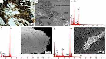
In order to confirm the chemical composition of the travertines, 19 EDS determinations were made on the different siliceous and calcareous facies described above. The analyses revealed a mixture of carbonates and silica in F1–F3 (e.g. Fig. 10a–c). Furthermore, silica replacement is prevalent in F4–F5, where we observed the texturally controlled transition between the two compositions. For F5 and F6, layers of Ca-rich and Mg-rich carbonates were detected (Fig. 10d), as well as siderite inclusions (Fig. 10e) in some portions of samples.
Photomicrographs, scanning electron microscope (SEM) backscatter images and EDS analyses from selected El Macanudo hot spring samples. (a, b) Shrubby lamination (F4.2), illustrating typical spatial relationship amongst carbonate (reddish brown), silicified (beige to translucent) and acid-altered (white, actual holes) portions of the sample. (c) EDS spectrum showing mixture of carbonate and silica. (d) EDS spectrum and SEM backscatter image of a stromatolitic carbonate-rich horizon (Fig. 8f, g), with Ca- and Mg-rich laminae (outlined with fine black lines). (e) EDS analysis and SEM backscatter image of a vug filled with siderite.

5. Discussion
5.a. Facies interpretation and modern analogues
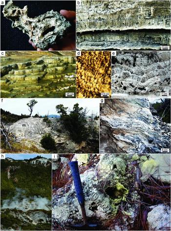
By comparison with modern analogues and other fossil examples, the El Macanudo deposit may be inferred as a high-enthalpy, bicarbonate hot spring setting with subaqueous and subaerial components, and which contains a special travertine facies unique to the 23 Jurassic geothermal sites known from the Deseado Massif (Guido & Campbell, Reference Guido and Campbell2011): the large conical stromatolites (in the order of ~100 concentric cones in a 25×110 m area). In particular, these laminated, cone-shaped F1 structures (Figs 4b, 5) are interpreted as subaqueous spring-vents, with stromatolite growth features of up to 1 m in height that were forming in ~1–5 m deep pools, based on comparisons with domal columnar stromatolites growing within the Map of Africa hot pool (~50°C) at Orakei Korako, New Zealand (cf. Drake et al. Reference Drake, Campbell, Rowland, Guido, Browne and Rae2014, their fig. 9A, p. 30). While this particular New Zealand example is from a sinter-forming geothermal setting, young (modern to sub-Recent) travertine analogues also occur at Yellowstone National Park (YNP) in the Mammoth Hot Springs area, and at sub-lacustrine springs in Nevada. Near Angel Terrace at YNP, we observed a small concentric cone structure (Fig. 11a) that was situated on the bottom of a small pool (now dry). Furthermore, groundwater spring-fed tufa in Big Soda Lake (Nevada, USA) also forms subaqueous, cone-shaped mounds (Rosen, Arehart & Lico, Reference Rosen, Arehart and Lico2004, their fig. 3B, p. 410) similar to F1 at El Macanudo, which accumulate at a rapid rate (≥ 30 mm yr−1). The F1 travertine conduits are preserved in silica, and are riddled with holes (Fig. 5c–e) that overprint the original crenulated to wavy, laminated, concentric stromatolitic fabric. The holes may represent dissolution produced by escaping acidic gases, discussed further below.
Photographs of modern to sub-Recent analogues for the Jurassic El Macanudo travertine deposit. (a–f) are from Mammoth Hot Springs, Yellowstone National Park, USA, and (g) and (h) are from the Taupo Volcanic Zone (TVZ), New Zealand. (a) Two small-scale, laterally concentric cones (viewed from their bases) from the Angel Terrace area, found in a recently dried, small pool (~2 m diameter). Compare to Figure 5a, inset. (b) Regular lamination in thinly bedded, vertical columnar structures, and intercalated with massive banded horizons, from the Angel Terrace area. Compare to Figures 4b and 6b. (c) Typical small travertine terraces forming on Minerva Terrace, which are internally laminated. (d) Modern shrub photo in a few centimetres of spring water, from the top of one modern terrace pool. (e) Detail of recently fossilized shrubby lamination from the Angel Terrace area. Compare to Figure 7e, f. (f) Calcareous mound (m) and adjacent, low-amplitude wavy bedding (w), from the Angel Terrace area. Compare to the Macanudo Sur Outcrop facies distributions map (Fig. 3) and Figure 4d, e. (g) Detail of low-amplitude wavy bedding at the base of a mound, from the Angel Terrace area. Compare to Figure 4d. (h) Overview of acid steam-heated altered sinter (steaming fumaroles around landslide blocks) and hydrothermally altered volcanic rocks (red and white patches in upper vegetated area) in cliffs along the active Paeroa Fault at Te Kopia, TVZ. (i) Detail of yellow, sulphur-lined fumarolic conduits and hollows (dark holes) developed in modern to sub-Recent sinter due to acid overprinting (Ngapouri sinter, TVZ). Hammer for scale is 40 cm long.

The F2 and F3 facies (Figs 4b, 6) are also inferred as subaqueous stromatolitic features, having developed their variable layering during growth in pools, in shallower water than F1, such that the thickness of each F2 and F3 layer appears to reflect the depth of water at the time of their formation. Figure 11b illustrates vertical columnar structures similar to F2 and F3 (cf. Fig. 6b) from an extinct, eroded, sub-Recent terrace margin near Angel Terrace at YNP. Figures 4b and 6a show a portion of the stratigraphy from Macanudo Norte, illustrating a deepening from the shallow pool setting of F2 and F3 at the base, developing upwards into the F1 spring-pool stromatolitic cones. Like F1, the F2 and F3 facies also display a strong silica overprint (Fig. 6c–e). The features preserve two types of holes (Fig. 6e–i), indicating two different kinds of gas-related events. The first is construed to have trapped gases during hot spring formation, which occasionally broke partition walls (Fig. 6f; type 1 concordant with laminations, mainly within F2). They may have been formed by photosynthetic gas release as they are enclosed within the inferred columnar stromatolitic textures and are similar to ‘bubble mats’ of mid-apron (travertine, sinter) settings (e.g. Hinman & Lindstrom, Reference Hinman and Lindstrom1996; Campbell et al. Reference Campbell, Sannazzaro, Rodgers, Herdianita and Browne2001; Guido & Campbell, Reference Guido and Campbell2009; Guido et al. Reference Guido, Channing, Campbell and Zamuner2010; Guido & Campbell, Reference Guido and Campbell2011, Reference Guido and Campbell2012). The second type of hole is surmised to have been caused by late diagenetic dissolution owing to etching by acidic gases (Fig. 6g–i; type 2 discordant with lamination, and affecting both F2 and F3).
The F4 irregular and shrubby lamination features (Figs 4c, 7) are interpreted as subaerial travertine terraces in a mid- to distal apron setting. On the modern travertine apron at Minerva Terrace (YNP), parallel laminae and beds are common (Fig. 11c), with well-preserved, microbe-coated, shrubby stromatolitic textures evident in shallow terrace pools atop Minerva Terrace (Fig. 11d), and in nearby dried pools of sub-Recent samples (Fig. 11e). Travertine shrubs, or bushes, are well known from shallow terracette pools of modern and Cenozoic hot spring settings, including YNP, German, Italian and other sites (e.g. Chafetz & Folk, Reference Chafetz and Folk1984; Pentecost, Reference Pentecost1990; Koban & Schweigert, Reference Koban and Schweigert1993; Guo & Riding, Reference Guo and Riding1994; Chafetz & Guidry, Reference Chafetz and Guidry1999; Fouke et al. Reference Fouke, Farmer, Des Marais, Pratt, Sturchio, Burns and Discipulo2000). Over more than a century of observation, these shrubby travertine fabrics have been variably interpreted as abiogenic or bacterial in origin (Pentecost, Reference Pentecost1990). The small volumes of organic matter extracted from modern travertine (Pentecost, Reference Pentecost1990) and the occlusion of microbial filaments or moulds by abiotic mineralization or post-depositional recrystallization (Chafetz & Guidry, Reference Chafetz and Guidry1999) have led some to conclude that the shrubs develop by inorganic processes. However, detailed textural study of a wide variety (age, location, mineralogy) of samples by Chafetz & Guidry (Reference Chafetz and Guidry1999) concluded that microbes act as catalysts for mineralization of all shrubby travertine fabrics, grading from strongly arborescent shrubs (bacterial influence dominates morphology) to geometric crystal shrubs (crystalline habit governed by physicochemical processes, but with bacterial clumps or their moulds at their centres). At El Macanudo, only those F4 travertine-terrace fabrics that underwent early silicification (e.g. Fig. 7i, j; represented by dark shrubs in hand sample that are translucent under the microscope) have preserved some of the details of the original, laminated, arborescent bacterial stromatolites. Otherwise, acidic pore fluids preferentially affected the shrubby portions of the laminations (Figs. 7g–i), recrystallizing the carbonate and creating the etched cavities as described for F1–F3, in some cases causing fabric-selective dissolution of shrub interiors while maintaining their broad outlines. The late acidic hydrothermal fluids also were injected into the irregular laminated facies (F4.2) and deposited kaolin clays (white in hand sample and dark in thin-section; e.g. Fig. 7a–d) parallel to and crossing bedding.
Facies 5 and 6 are spatially associated with each other in the Macanudo Sur area, and are interpreted as wavy bedded, subaerial travertine slope deposits (F5) overlain by travertine mound (F6) deposits (e.g. Fig. 4d, e). In the Angel Terrace area of YNP, we found sub-Recent vent mounds (Fig. 11f) with stromatolitic growth on top and low-amplitude wavy bedding adjacent to and beneath the mound features (e.g. Fig. 11g). The F6 Macanudo mounds comprise crenulated, concentric stromatolitic features on top (Fig. 9a) and localized breccia in the core of the vent, visible where the mounds are eroded (Fig. 9b). This F6 facies can be compared with F1 in that both indicate proximity to vent areas and had stromatolites growing around the vents, but one developed cones under water (F1) and the other formed mounds on land (F6).
The inferred features of steam-heated acidic overprinting of the El Macanudo hot spring deposits, as deduced from the ubiquitous hollows and irregularly porous textures that riddle F1–F4, in particular, have analogues in the geothermal fields of the Taupo Volcanic Zone, New Zealand. Tikitere (Hell's Gate), Te Kopia and Ngapouri contain comparable examples, where acidic steam condensate overprints siliceous hot spring deposits and adjacent rocks (Fig. 11h), creating gas escape hollows and precipitating native sulphur (Fig 11i).
5.b. Evolutionary history of the Jurassic El Macanudo geothermal system
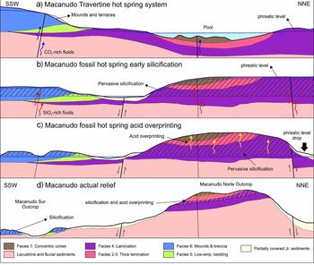
El Macanudo provides an opportunity to assess the impact of depositional and post-depositional history on fossil (150 Ma) hot spring microfacies and on the microbial fossil preservation state of thermogene travertines in the geological record. A detailed evolutionary history may be constructed (Fig. 12) because of the structurally undisturbed nature of the Jurassic deposit. Their detailed mapping and paragenetic study, described herein, indicate spatial and topographic relationships amongst travertine formation, its early silicification and the late-stage acid overprinting features and their distributions.
(a–d) Schematic NNE–SSW cross-section along Macanudo Norte and Macanudo Sur outcrops and their evolution from Late Jurassic to Recent times to produce the inverted topography and mineralization pattern seen today. Details in text.

The Mirasol low area at El Macanudo (Fig. 2) is interpreted as having been a high-relief area during Cenozoic times, since it was not covered by the surrounding Eocene flood basalts. This high-relief area could have been a Jurassic volcanic centre that was subsequently intensely eroded because the younger basalts flowed outwards from faults along the NE, NW and SE borders of the Mirasol low area (Fig. 2). Such erosion could have been enhanced in areas of Late Jurassic hydrothermal alteration, which may have physically and chemically weakened the rocks within the pseudosinters (silicified travertines) and travertines of the Macanudo palaeo-hot spring area. The southern ignimbrite (Fig. 2) also flowed along a NE–SW-oriented, high-palaeo-relief area that was not covered by basalts. It probably travelled towards the SW, away from the interpreted volcanic centre in the Mirasol low area, and exhibits a Jurassic SW-dipping slope. This general geological affiliation of aligned ignimbrites and hot springs is also regionally consistent with the Flecha Negra ignimbrite flow in the La Esperanza area (Echeveste et al. Reference Echeveste, Fernández, Llambias, Tessone, Schalamuk, Bellieni, Piccirillo and De Min1999, FN of Fig. 1), about 50 km south of Macanudo, which is close to the Jurassic Cerro Tornillo hot spring area (Mykietiuk & Lanfrancini, Reference Mykietiuk and Lanfrancini2004, CT of Fig. 1).
As discussed in Section 5.a, the El Macanudo petrographic and mineralogical observations of this study (Figs 5–10) confirm that the siliceous facies are carbonates replaced by silica, as was proposed by Schalamuk et al. (Reference Schalamuk, Guido, de Barrio, Fernandez and Stanley1999). Specifically, Facies 1–4, the subaqueous travertine pool and surrounding subaerial travertine apron terrace associations of Macanudo Norte are composed of silica with few calcareous relics. In addition, the subaerial travertine mound facies associations of Macanudo Sur (F5, F6) are mainly calcareous, showing only patchy silicification of these mound deposit affiliations, with remnant microbial stromatolite and laminate fabrics (Fig. 8d, e) in the F5 wavy bedding found at the base of subaerial mounds. Some relict stromatolite morphologies (branched columnar) also are preserved in carbonate where there is partial iron replacement and coating by a fibrous cement (Fig. 8f, g), but even so their internal fine laminae have been recrystallized. Some travertine bacterial shrubs from elsewhere also have been moderately well preserved by similar sparry cement coatings (cf. Chafetz & Guidry, Reference Chafetz and Guidry1999, their fig. 5d, p. 64).
Considering the El Macanudo travertine facies and their mineralogical distributions with respect to topography, a silica cap replacement likely developed in the area at approximately the 660 m topographic limit (Fig. 3). Detailed mapping, together with strike and dip measurements of primary sedimentary layering, shows structurally controlled vent areas at both northern and southern outcrops, mainly located along regional NNE- and ENE-trending faults, with another interpreted vent source north of the Macanudo Norte Outcrop, but not preserved (Fig. 3). Strike and dip measurements from in situ outcrops of the hot spring deposits (e.g. Fig. 4c) indicate a concentric distribution of travertine facies with respect to the two interpreted vent areas: ENE-oriented F1 at the Macanudo Norte Outcrop, and NNE-oriented F6 at the Macanudo Sur Outcrop. The Macanudo Norte Outcrop rocks represent a silica-replaced travertine apron sequence at a higher palaeo-elevation (preserved also in the present day; Fig. 3), with development of large subaqueous stromatolites in a deep travertine-terrace pool or in a shallow, geothermally influenced lacustrine environment; whereas, the Macanudo Sur Outcrop represents a subaerial travertine mound sequence. The lower topographic limit of pervasive regional silicification was also mapped for both outcrops (Fig. 3). Early silicification was responsible for exceptional preservation of some fabrics and stromatolitic structures, especially in the Macanudo Norte Outcrop area, but most were largely affected by a later steam-heated system, probably due to a drop of the palaeo-phreatic surface, which subsequently produced the intense argillization of the host rocks and the acid dissolution hollows observed in Macanudo Norte F1–F4 travertine.
Figure 12 illustrates our interpretation of the evolutionary history of the El Macanudo silica-carbonate deposit. Three different events occurred during Late Jurassic time at El Macanudo (Fig. 12a–c) that were related to the large and long-lasting hydrothermal systems active across the Deseado Massif at this time. Themogene travertines were primarily precipitating in a conventional hot-spring-related geothermal system (see fig. 3B in Guido & Campbell, Reference Guido and Campbell2011), with subaerial mound products in the south, and subaqueous pool and surrounding subaerial terrace features forming in the north (Fig. 12a). Subsequently, active faulting impacted on the CO2-rich geothermal system, introducing pervasive silicification that was probably related to regional migration of silica-saturated hydrothermal fluids (Fig. 12b). This was the time when exceptional preservation of some shrubby bacterial stromatolites likely occurred. Following this extensive silicification episode, a change in palaeo-phreatic water level commenced. A drop in the water table exposed the northern part of the outcrops to acid alteration (Fig. 12c). Then, this area was probably partially covered by friable Cretaceous and Tertiary sedimentary deposits that were eroded by regional uplift of the entire massif (Guido & Campbell, Reference Guido and Campbell2011), exposing today these slightly tilted Jurassic palaeo-surfaces (Fig. 12d).
5.c. Implications for the preservation of Lagerstätte in the extreme (palaeo)environments of fossil hot springs
Because fossil microbial preservation is less likely in thermogene travertines compared to siliceous sinters, owing to ready neomorphism and other diagenetic effects in carbonates, sinters are more likely to produce fossil Lagerstätte, such as in the Jurassic San Agustín sinter in the Deseado Massif (SA of Fig. 1) (Guido et al. Reference Guido, Channing, Campbell and Zamuner2010; Channing et al. Reference Channing, Zamuner, Edwards and Guido2011; García Massini et al. Reference García Massini, Channing, Guido and Zamuner2012) and the Devonian Rhynie Chert in Scotland (Trewin, Reference Trewin, Bock and Goode1996 and references therein). Silicification of some thermogene travertines of the Deseado Massif has preserved microbial structures well at the micro-scale, as in the Cerro Negro deposit (CN of Fig. 1; Guido & Campbell, Reference Guido and Campbell2012), and the silicified bacterial shrubs described here from El Macanudo. However, for such high-quality preservation to occur, these pseudosinters had to have silicified early during diagenesis; otherwise, carbonate weathering, hydrothermal alteration and/or burial diagenesis would have eliminated fine-scale microbial and other primary features before they could be preserved by subsequent silicification or other mineralization. Finally, we note that those silicified travertines and sinters in the Deseado Massif that are free from late-stage acid alteration signatures also tend to have moderate to excellent lithofacies and biofacies preservation (e.g. La Marciana, San Agustín, Claudia, Cerro Negro; Fig. 1; Guido & Campbell, Reference Guido and Campbell2011), and thus we predict a similar pattern may hold for other palaeo-geothermal deposits elsewhere in the world.
Acknowledgements
We thank INREMI and The University of Auckland for institutional and other support. Funding was provided by the National Geographic Society, Subsidios Automáticos and PICT. Alan Channing, Jack Farmer, Nancy Hinman and Pat Browne furnished field logistical assistance and fruitful discussions. We are grateful to two anonymous reviewers who improved the quality of the manuscript.