


1. Introduction
In the late 3rd millennium BC, by the conquest of Susa in c. 2330 BC by Sargon of Akkad (Potts Reference Potts2016: 120), Akkadian became the language of administration in the land of Elam (De Graef Reference De Graef and Potts2013: 264–275; also Foster Reference Foster2016: 73ff.), a practice which continued until the middle of the 2nd millennium BC with the administrative archive discovered at Haft Tappeh, which is dated to c. 1400 BC (Basello Reference Basello, Álvarez-Mon and Garrison2011: 61; Herrero Reference Herrero1976). Although the texts of the archive of Haft Tappeh are written in Akkadian, most of the onomasticon and also a few month names are in Elamite (the others are linguistically Akkadian; Basello and Giovinazzo Reference Basello, Giovinazzo, Álvarez-Mon, Basello and Wicks2018: 486–487). During this period, one can observe that the language of administration has started to change from Akkadian to the domestic language of Elamite. At the end of the second and beginning of the 1st millennium BC, the Elamite language began to be used as the main language for administration and record keeping. One of the first archives, so far, in which Elamite has been used, is the archive of Anšan, which was brought to light in the excavation at the archaeological site of Malyan in the highlands of Fars (Carter Reference Carter1996; Stolper Reference Stolper1984). The archive of Anšan mainly documented the delivery of raw metals to individuals under the control of the governmental organisation of the city. These raw materials were used to produce metal objects, in order to equip a temple or a building (Sajjadiyan and Makvandi Reference Sajjadiyan and Makvandi2024). Even though the texts of the archive of Anšan are written in Elamite, still, they contain a high proportion of Akkadian logograms and loanwords (De Graef Reference De Graef and Potts2013: 278; Stolper Reference Stolper1984: 10–28). By studying the archives of Haft Tappeh, situated about 18km South-East of the ancient city Susa in the region Khuzestan, dating back to the 15th century BC (Mofidi-Nasrabadi Reference Mofidi-Nasrabadi2013: 161), Goshtaspi Tappeh, situated in the Kohgiluyeh and Boyer-Ahmad province in the region of Basht near the village of Khan Ahmad (Ata’i and Rayat Reference Atayi and Rayat2017: 346–347; Rayat and Sallaberger Reference Rayat, Sallaberger, Bernbeck, Eberhardt and Pollock2023), and Anšan, the trend of the emergence of Elamite language as the instrument for the documentation and administration can be witnessed.
The process of forming and developing an Elamite administrative tradition, from the archive of Anšan, has continued in the Neo-Elamite archive of the Acropolis of Susa (SAT). The SAT corpus, with 299 published texts, represents the second major corpus of Elamite tablets. This corpus was discovered by the French Delegation directed by J. de Morgan in the Acropolis of Susa (de Morgan Reference De Morgan1905: 34–36). The SAT archive, whose date ranges from the late 7th century to the time of Cyrus II according to different scholars, records the distribution of weaponry, garments, tools and containers (Basello Reference Basello, Álvarez-Mon and Garrison2011: 61–62). Since the SAT corpus and the texts of the archive of Anšan are both written in Elamite, when compared, the SAT offers valuable insight into the evolution of the Elamite administrative tradition which continued in the Achaemenid era. SAT highlight the shift in archival practices, from a reliance on Akkadian traditions to a more local approach, eventually becoming distinctly Elamite.
This study aims to present and analyse the SAT corpus in detail, examining its structure, content, and significance within the broader framework of administrative practices. By conducting a comparative analysis with the texts from the archive of Anšan, this research seeks to trace the evolution of administrative traditions over time, identifying key continuities and transformations in record-keeping, bureaucratic procedures, and institutional frameworks. Through this analysis, a deeper understanding of the administrative landscape of the period will be achieved, contributing to the broader discourse on ancient record-keeping and institutional development.
2. Methodological and Practical Challenges
The extant texts are only partially translated, and many additional fragments and tablets remain unstudied. Furthermore, the available sketches and designs of the tablets are not sufficiently reliable. The transcriptions of these texts suffer from numerous errors and misreadings, leading to translations that are unreliable. Even the translation of the transcribed portions is not dependable. Despite these difficulties, the translations provided by Scheil—and subsequently by Jusivof—have been adopted as the primary reference for this corpus. Consequently, this study offers a general overview of the tablets without focusing on any single aspect, due to the uncertainties inherent in the readings and translations. The present analysis ultimately highlights the evolution of archival traditions from the Middle Elamite archive of Anshan to the archive of the Acropolis of Susa.
3. The discovery of the SAT archive
In the winter of 1897–98, the French archaeological Delegation in Susa led by de Morgan, among many trenches, excavated two parallel trenches on the mound of the Acropolis, namely Tr. 7 and Tr. 7a with a width of 10 metres, in order to better-understand the context of the Achaemenid thick mud-brick enclosure wall, running along the crest of the citadel from west to the middle of the tell (Figs. 1–2; de Morgan et al. Reference De Morgan, Jéquier and Lampre1900: 88–89). In the excavations of the following season, winter of 1898–1899, two new trenches situated in the continuation of Trenches 7 and 7a, named Tr. 16 and Tr. 16a, were excavated in order to complete the picture of the phases of the Tell (de Morgan et al. Reference De Morgan, Jéquier and Lampre1900: 113). Taken together, these two trenches measure 80 metres in length, 10 metres in width, and an average depth of 5.30 metres (4,240 cubic metres). Besides the trench Tr. 16, in its southern side, trench Tr. 17 with a depth of 5.50 metres and a width of approximately 6 to 7 metres at the base was excavated (de Morgan et al. Reference De Morgan, Jéquier and Lampre1900: 127–130).
Map of Acropolis mound, showing excavated trenches of the French Delegation led by de Morgan. The red square shape shows the approximate location of the discovery of the archive of the Acropolis (de Morgan et al. 1900; elaborated by present authors)

Fig. 1 Long description
A cross-sectional map of the Acropolis mound. The map shows the excavated trenches of the French Delegation led by de Morgan. The trenches are depicted with hatched lines. A red square shape indicates the approximate location of the discovery of the archive of the Acropolis. The map includes contour lines representing elevation changes and various labeled regions. The inset in the top left corner provides an overview of the entire Acropolis mound with the same red square marking the specific area of interest.
the plan of the Acropolis mound showing the location of major finds (after Heim Reference Heim, Harper, Aruz and Tallon1992: 124, Fig. 41; elaborated by present authors)

At 4 metres depth, beneath the Achaemenid phase at the junction of these trenches, i.e. trench Tr. 17 with trench Tr. 16, a small square building decorated by glazed bricks was discovered (Figs. 2–3; de Morgan et al. Reference De Morgan, Jéquier and Lampre1900: 127–130, de Morgan Reference De Morgan1905: 34). De Morgan in Jan. 1901 continued the excavations (expanding also the trench Tr. 16 to south), and removed the aforementioned small square building, which resulted in the discovery of its foundation inscription (EKI 72 = IRS 57) showing that the building was a Neo-Elamite temple constructed by the order of Shutruk–Nahhunte II (r. 717–699 BC.) (Basello Reference Basello, Tavernier, Gorris, Abraham and Boschloos2018: 231; Henkelman Reference Henkelman2012: 371–372; de Morgan Reference De Morgan1905: 34).
« Dès la campagne de fouilles de 1898–99 nous avions découvert, dans la partie Sud-Est de la Citadelle, à 4 mètres de profondeur, un petit édifice carré construit en briques émaillées et dont l’attribution nous restait inconnue. J’avais fait conserver cet édicule, afin de ne pas rompre l’ordonnance de nos tranchées. Plus tard (janvier 1901), lorsque le plan en fut entièrement relevé, puis qu’il eut été démoli, les textes de fondation nous apprirent que c’était un temple appartenant à l’époque élamite et construit par le roi Choutrouk-Nakhounte II » (de Morgan Reference De Morgan1905: 34).
The position of the Temple of Shutruk-Nahhunte II and surrounding structures (de Morgan Reference De Morgan1905: Fig. 66, elaborated by present authors)

Fig. 3 Long description
A diagram of an archaeological site layout showing various trenches and structures. Panel A: A rectangular trench labeled 4 metres depth. Panel B: A large rectangular area with a smaller square building labeled 4 metres depth. Panel C: A complex layout of interconnected trenches with various dimensions labeled in metres. Panel D: A smaller rectangular trench labeled 4 metres depth. Panel E: A circular feature labeled Sepulture 6 by 5 metres. Panel F: A rectangular trench labeled 4 metres depth. Panel G: A rectangular trench labeled 4 metres depth. Panel H: A rectangular trench labeled 4 metres depth. Panel I: A rectangular trench labeled 4 metres depth. Panel J: A rectangular trench labeled 4 metres depth. Panel K: A rectangular trench labeled 4 metres depth. Panel L: A rectangular trench labeled 4 metres depth. Panel M: A rectangular trench labeled 4 metres depth. Panel N: A rectangular trench labeled 4 metres depth. Panel O: A rectangular trench labeled 4 metres depth. Panel P: A rectangular trench labeled 4 metres depth. Panel Q: A rectangular trench labeled 4 metres depth. Panel R: A rectangular trench labeled 4 metres depth. Panel S: A rectangular trench labeled 4 metres depth. Panel T: A rectangular trench labeled 4 metres depth. Panel U: A rectangular trench labeled 4 metres depth. Panel V: A rectangular trench labeled 4 metres depth. Panel W: A rectangular trench labeled 4 metres depth. Panel X: A rectangular trench labeled 4 metres depth. Panel Y: A rectangular trench labeled 4 metres depth. Panel Z: A rectangular trench labeled 4 metres depth.
To the south of Trench Tr. 17, the remains of an Achaemenid thick mud-brick wall were discovered. Subsequently the excavation showed that, on the inner side of the wall, there were some light constructions which were built by mud-bricks of the same size as the thick wall, suggesting that they belonged to the same Achaemenid phase. De Morgan adds that the foundation of these structures, probably even the thick mud-brick wall, were no more than 3 metres deep. These structures, which were formed leaning against the inner section of the thick mud-brick wall, were formed above a more ancient phase, covering it partially. By the continuation of the excavation, around 5 metres deep below the claimed Achaemenid phase, there were a number of structures and a pavement which are partially documented. These structures belonged to the same phase of the temple of Shutruk-Nahhunte II. These structures were recognized by de Morgan as Elamite palaces and temples (Figs. 2–3). It was in this phase that de Morgan, without putting himself to much trouble and giving any detailed information concerning the archaeological context of the discovery, just explained
« Les fondations de cet ensemble [les structures Achéménide] ne se trouvaient pas à plus de trois mètres de profondeur; elles s’appuyaient sur les débris plus anciens, recouvraient en partie le petit édifice de briques émaillées dont il vient d’être parlé, et passaient au-dessus de chambres élamites renfermant une grande quantité de tablettes en terre crue » (de Morgan Reference De Morgan1905: 36).
After reading the excavations report of de Morgan, it can be concluded that the tablets were found inside some chambers, beside other Elamite structures in the south of the Temple. Unfortunately, it remains unclear whether the chambers that contain the tablets are included in the published plan (Figs. 2–3) or not; nevertheless, the general context is what has been designed in the plan.
The results of the excavations in the south-eastern part of the Acropolis show that under the thick enclosure wall and some shallow structures all dated to the Achaemenid period, an Elamite phase with a different material culture is represented. The discovery of the foundation inscription of the Temple, belonging to Shutruk-Nahhunte II, suggested a dating to the end of the 8th and beginning of the 7th century, i.e. 717–699 BC (Gorris Reference Gorris2021). This foundation inscription provides a general date, offering a time range that helps us understand the phase under discussion. Additionally, the fact that the Elamite phase was situated immediately beneath the Achaemenid structures, confirm a late Elamite dating, i.e. c. 6th and 7th century BC, (de Miroschedji Reference Miroschedji1978: 213; de Morgan Reference De Morgan1905: 34–36), which could be attributed also to the SAT corpus. However, unlike the archaeological evidence from this phase, the tablets could offer a more precise dating on their own (see below).
The excavation of this late Elamite phase resulted in the discovery of the 299 published SAT in Neo-Elamite language and script (for the dating of Neo-Elamite III see Gorris Reference Gorris2020; Potts Reference Potts2016: 249–250; for the discovered tablets see Álvarez-Mon Reference Álvarez-Mon, Tavernier, Gorris and De Graef2023: 276; Basello Reference Basello, Tavernier, Gorris, Abraham and Boschloos2018: 230; Basello and Giovinazzo Reference Basello, Giovinazzo, Álvarez-Mon, Basello and Wicks2018: 488; Scheil Reference Scheil1907). These tablets were largely been published by V. Scheil in MDP 9, 1–298, and another tablet probably belonging to this collection was published in MDP 11 as 309; besides these tablets, there are hundreds of small fragments in the Louvre Museum (Basello Reference Basello, Álvarez-Mon and Garrison2011: 61; Basello and Giovinazzo Reference Basello, Giovinazzo, Álvarez-Mon, Basello and Wicks2018: 488–489).
4. Dating of the Neo-Elamite archive of Susa
The SAT corpus, based on the fact that the texts were discovered in a phase exactly below the Achaemenid phase, was dated by Scheil to the period prior to the Assyrian destruction of Susa that happened in 647 BC (Scheil Reference Scheil1907: iii). Afterwards, G. Cameron, based on the similarities between the SAT and Persepolis texts (Persepolis Fortification and Treasury Tablets) in form, method of dating and seal impressions, proposed an even lower date, near to the reign of Cyrus II (Cameron Reference Cameron1948: 24, fn. 2). P. Amiet, based on glyptic evidence, overruled the hypothesis of Scheil and suggested that this corpus should be dated after the last quarter of the 7th century BC and even later in the first half of the 6th century BC (Amiet Reference Amiet1973: 3–6, 24–25). E. Reiner, based on the supposed influence of Babylonian, e.g. on clay envelopes and seal impressions witnessed by the SAT corpus, suggested a date after the 7th century BC (Reiner Reference Reiner, Friedrich, Reiner, Kammenhuber, Neumann and Heubeck1969: 63). P. de Miroschedji, focusing on the archaeological context and the cylinder seal impressions, suggested the second half of the 7th and 6th centuries BC (de Miroschedji 1982: 60; Reference Miroschedji1990: 79–81). Carter and Stolper, also by referring to stratigraphy and stylistic studies of the seals impression, date the SAT corpus to the very end of the 7th and the first half of the 6th century BC (Carter and Stolper Reference Carter and Stolper1984: 54). W. Hinz in 1987, based on the palaeography and the onomastics of certain individuals, believed it possible to demonstrate that the SAT corpus was earlier than 680 BC and could be dated to a few years after the battle of Halule and more precisely to the reign of Ummanunu from 688 to 681 BC (Hinz Reference Hinz and de Blois1987: 125–127). M.-J. Steve proposed to place them in the Neo Elamite III B period and more precisely in 605–539 BC (Steve Reference Stève1992: 22). M. W. Stolper suggested the tablets to be from sometimes between Ashurbanipal’s destructive conquest of Susa and the Achaemenid occupation of the 6th century BC, dating them to the end of 7th and the beginning of 6th century BC (Stolper Reference Stolper, Harper, Aruz and Tallon1992: 260).
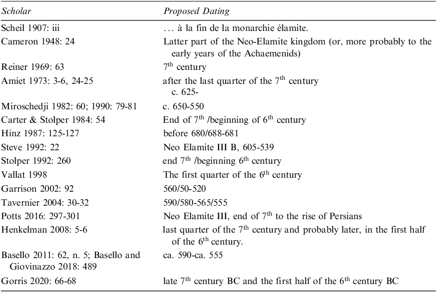
F. Vallat, based on the iconography of the seal impressions and also some individuals mentioned in the texts who might correspond to the names of Elamite kings ruling in the first half of the 6th century BC, proposed a dating to the first quarter of the 6th century BC (Vallat Reference Vallat1998). M. B. Garrison, by examining the glyptic evidence and its stylistic connection to the Persepolis archive sealings and to the artistic traditions in the highlands, proposed a dating from c. 550 to 520 BC (Garrison Reference Garrison2002: 79–92). J. Tavernier after analysing the proposed dating of Vallat and due to the advanced use of broken writings, common in Achaemenid Elamite, suggested the tablets to be from 590/580–565/555 BC (Tavernier Reference Tavernier2004: 30–35). E. Gorris noting that the phonographic spellings of some of words (e.g su-un-ki “king” and šá-ak “son”) were partially replaced by logograms (e.g. EŠŠANA for su-un-ki and DUMU for šá-ak), a characteristic that also appears in the Persepolis Bronze Plaque, besides several other linguistic innovations, suggested the corpus to belong to the late 7th century BC and the first half of the 6th century BC (Gorris Reference Gorris2020: 66–68). Other scholars by consensus agreed on the proposed dating to the late 7th century BC and the first half of the 6th century BC (Basello and Giovinazzo Reference Basello, Giovinazzo, Álvarez-Mon, Basello and Wicks2018: 489; Henkelman Reference Henkelman2008: 5–6; Potts Reference Potts2016: 297–301). Therefore, there is an agreement among the majority of scholars that the tablets dated back to the late 7th century BC and the first half of the 6th century BC (Table 1). Accordingly, the SAT archive is a post-Assyrian conquest (647 BC) testimony for the continuity of the royal power in Susa, the bureaucracy and palace economic institution, and the close network and connections among Elamite cities in and beyond Susiana (Henkelman Reference Henkelman2008: 6).
The proposed dates concerning the SAT archive (after Henkelman Reference Henkelman2008: 6 fn. 10, elaborated by the present authors)

Table 1: Long description
A table with two columns and thirteen rows. The first column is labeled Scholar and the second column is labeled Proposed Dating. The table lists the following data: Row 1: Scholar, Scheil 1907: iii; Proposed Dating, la fin de la monarchie elamite. Row 2: Scholar, Cameron 1948: 24; Proposed Dating, Latter part of the Neo-Elamite kingdom (or, more probably to the early years of the Achaemenids). Row 3: Scholar, Reiner 1969: 63; Proposed Dating, 7th century. Row 4: Scholar, Amiet 1973: 3-6, 24-25; Proposed Dating, after the last quarter of the 7th century c. 625-. Row 5: Scholar, Miroschedji 1982: 60; 1990: 79-81; Proposed Dating, c. 650-550. Row 6: Scholar, Carter Stolper 1984: 54; Proposed Dating, End of 7th/beginning of 6th century. Row 7: Scholar, Hinz 1987: 125-127; Proposed Dating, before 680/688-681. Row 8: Scholar, Steve 1992: 22; Proposed Dating, Neo Elamite III B, 605-539. Row 9: Scholar, Stolper 1992: 260; Proposed Dating, end 7th/beginning 6th century. Row 10: Scholar, Vallat 1998; Proposed Dating, The first quarter of the 6th century. Row 11: Scholar, Garrison 2002: 92; Proposed Dating, 560/50-520. Row 12: Scholar, Tavernier 2004: 30-32; Proposed Dating, 590/580-565/555. Row 13: Scholar, Potts 1996: 297-301; Proposed Dating, Neo Elamite III, end of 7th to the rise of Persians. Row 14: Scholar, Henkelman 2008: 5-6; Proposed Dating, last quarter of the 7th century and probably later, in the first half of the 6th century. Row 15: Scholar, Basello 2011: 62, n. 5; Basello and Giovinazzo 2018: 489; Proposed Dating, ca. 590-ca. 555. Row 16: Scholar, Gorris 2020: 66-68; Proposed Dating, late 7th century BC and the first half of the 6th century BC.
5. The evolution of administration from Anšan to Susa
In order to have a better understanding of the administrative traditions and the way the bureaucratic activities were handed out in different regions and periods, one should study the subject in the longue durée to see the process and also to appreciate the needs that resulted in the formation of an administrative formula.
At the end of the second millennium and the beginning of the first millennium BC, one of the first, to date, Elamite administrative archives was established in the city of Anšan (Malyan). This archive initiated a tradition that is evident also in the SAT corpus and continued later in the Persepolis archives (PFT and PTT). While a detailed comparative study between the SAT and Persepolis archives has been made by Basello (Reference Basello, Álvarez-Mon and Garrison2011; Reference Basello and Mofidi-Nasrabadi2013; Reference Basello, Tavernier, Gorris, Abraham and Boschloos2018), a similar comparison between the archive of Anšan and SAT archive is still lacking. To better comprehend the administrative practices of 6th-century BC Susa—and, by extension, the broader southwestern Iranian plateau—we focus on analysing the Neo-Elamite archive of the Acropolis at Susa in comparison with the Middle Elamite archive of Anšan at Malyan.
In terms of function, the administrative texts of Anšan deal with the disbursal of raw metals among artisans and craftsmen, and subsequently the production of decorative or ritual objects. The transactions mentioned in the texts are, in fact, inter-organisational, with materials and products likely moving within the governmental organisation of the city of Anšan (Sajjadiyan and Makvandi Reference Sajjadiyan and Makvandi2024; Stolper Reference Stolper1984). This archive, belonging to a governmental organisation at the city of Anšan, had been probably tasked to construct and equip a temple in the city of Anšan. While the temple was in construction, the organisation oversaw supervising the flow of raw metals reaching the organisation and the delivery of them to the responsible individuals to produce the required artifacts. It is not clear who the recipients are, but among these individuals there are administrators and artisans. In the next step, the organisation oversaw the produced artifacts and their placement in the demanded location, probably in the newly constructed temple (Sajjadiyan and Makvandi Reference Sajjadiyan and Makvandi2024: 139–142).
The SAT generally deals with the production of weaponry and (military related?) clothing and their disbursal among different groups of individuals (Basello and Giovinazzo Reference Basello, Giovinazzo, Álvarez-Mon, Basello and Wicks2018: 489; Scheil Reference Scheil1907): the process of disbursal of products and goods among individuals in the archive was probably an external activity, meaning that the materials were sent out of the organisation. In the last lines of SAT (the so-called colophon) a toponym is often mentioned, while there are no toponyms mentioned in Anšan tablets except for Anšan itself.
Although, the two archives on the whole show the same function of production and distribution in southwestern Iran, they also demonstrate two different aspects of distribution, i.e. the inter-organisational flow of materials (Anšan) and the distribution outside of the organisation (SAT).
5.1. The content of the SAT tablets
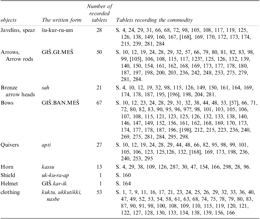
The texts record the delivery of different types of materials and goods, such as weaponry (Table 2), clothing, and containers to individuals or different groups of people in different locations which will be discussed in the following pages.
the mentioned weapons in the tablets of the Neo-Elamite archive of Acropolis, Susa (after Alvarez-Mon Reference Álvarez-Mon, Tavernier, Gorris and De Graef2023: 277)

Table 2: Long description
The table has four columns and ten rows, detailing weapons mentioned in Neo-Elamite tablets. The columns are labeled ‘objects’, ‘The written form’, ‘Number of recorded tablets’, and ‘Tablets recording the commodity’. The rows list different weapons and their corresponding data. Row 1: Javelins, spear, šu-kur-ru-um, 28, S. 4, 24, 29, 31, 66, 68, 72, 98, 105, 108, 117, 119, 125, 126, 138, 149, 160, 167, [168], 169, 170, 172, 173, 174, 215, 239, 281, 284. Row 2: Arrows, Arrow rods, GIŠ.GI.MEŠ, 50, S. 10, 12, 19, 24, 28, 29, 32, 57, 66, 79, 80, 81, 82, 83, 98, 99, [105], 106, 108, 115, 117, 123?, 125, 126, 132, 139, 140, 150, 154, 161, 162, 168, 169, 173, 177, 178, 180, 187, 197, 198, 200, 203, 236, 242, 248, 253, 275, 279, 281, 284. Row 3: Bronze arrow heads, sah, 21, S. 4, 10, 12, 19, 32, 98, 115, 126, 149, 150, 161, 164, 169, 174, 178, 187, 195, [196], 198, 204, 281. Row 4: Bows, GIŠ.BAN.MEŠ, 67, S. 10, 12, 23, 24, 28, 29, 31, 32, 38, 44, 48, 53, [57], 66, 71, 72, 80, 82, 83, 90, 95, 96, 97?, 98, 101, 103, 105, 106, 107, 108, 115, 121, 123, 125, 126, 132, 133, 138, 140, 146, 147, 149, 152, 156, 161, 162, 168, 169, 170, 173, 174, 177, 178, 187, 196, [198], 212, 215, 223, 236, 240, 269, 275, 281, 284, 295, 298. Row 5: Quivers, apti, 27, S. 10, 12, 19, 24, 28, 29, 44, 48, 66, 82, 95, 98, 99, 101, 105, 106, 123, 125, 126, 132, [168], 169, 173, 198, 236, 240, 253, 295. Row 6: Horn, kassu, 13, S. 4, 29, 38, 109, 126, 287, 30, 47, 154, 166, 298, 28, 96. Row 7: Shield, uk-ku-ra-ap, 1, S. 160. Row 8: Helmet, GIŠ.kar-ik, 1, S. 164. Row 9: Clothing, kuktu, ukkutikki, nasbe, 53, S. 1, 7, 9, 11, 16, 17, 21, 23, 24, 25, 26, 29, 32, 33, 36, 40, 47, 49, 52, 53, 54, 58, 61, 63, 68, 74, 75, 78, 79, 80, 83, 87, 90, 91, 98, 100, 108, 109, 110, 115, 119, 120, 121, 122, 127, 128, 130, 133, 134, 138, 139, 156, 166.
The SAT corpus, studied and translated by Scheil (Reference Scheil1907), and J. B. Jusifov (Reference Jusifov1963) offers valuable insights into the management and transfer of military equipment in ancient Susa. The texts reference various items, including javelins, bows, reed-arrows, bronze arrowheads, quivers, and horns. At least 28 texts list javelins, 50 texts list reed-arrows, 20 mention bronze arrowheads, 28 record quivers, 13 refer to horns, shields, helmets, and many unknown other items. For instance, S 57 mentions the delivery of a certain amount of weaponry to mentioned individuals:
1. 300 GIŠ[BANMEŠ]
1. 300 arcs,
2. BEAd-da-bar-ru-[na]
2. de Addabarru;
3. 180 GIŠGIMEŠ
3. 180 cannes (ou hampes)
4. BEKam-hu-ma-r[a]-na
4. de Kamhumara.
5. PAP hu-ut-tuk-ki lu-
5. Le tout envoyé, parvenu
6. ip-ka GÌR BEKu-du-
6. à l’intendant
7. da-ka-ka-na
7. Kuddakaka.
8. ITI.KIN.UD
8. Un jour du mois de Ululu.
9. AŠŠu-šu-un
9. à Suse
Numerous testimonies of different types of distributed garments are visible in the tablets. Since most of these garments were mentioned in the same texts together with different types of weaponry, they could be of military use, however it is not certain. These garments were mentioned in different categories and types–the meanings of which are not clear for us–, e.g., S 1 kuktu, S 87 ukkutikki, S 120 nasbe, and different colours, e.g. blue, white, red. These garments were mentioned in 53 tablets. For instance, S 1Footnote
1
mentions the transfer of a certain kind of clothing:
1. 60+10 ku-uk-tum
70 vêtements kuktum luxueux ont été façonnés. Addabarru (les) a reçu. Un jour du mois de Ululu. Localité de Mat Ursan.
2. bu-ur-nu-ip-
3. pe ma-ul-
4. la-ka BEAd-
5. da bar-ru
6. du-iš-da
7. ITI.KIN.UD
8. AŠMat Ur-ša-an
There also are some indications of different types of containers in the SAT corpus, e.g. kabut and zappan in S 5Footnote
2
:
1. 2 GIŠkap-pi KÙ.BABBARMEŠ-na
2 silver paterae, 1 royal zappan vessel. Total 3, Hubanukas commissioned. 60 cups with… stone, Ummandada commissioned. 1 bolt (?)…, Huban commissioned… 1 bolt (?)… Naprama commissioned.
2. 1 GIŠza-ap-pa-an šá-ah-ši
3. PAP 3 kur-mín BEhu-ban-nu-kaš-[na]
4. 60 ka4-bu-ut li-ut-tur
5. HAR-ip-na
6. kur-mín BEum-man-da-da-na
All objects… Hubankidin son of the king…, tenth month…
7. 1 GIŠšu-ur kur-mín BEhu-ban…
8. 1 GIŠšu-ur kur-mín BEnap-ra-ma
9. PAP hu-ut-[tuk-ki…] BEhu-ban-
10. -ki-din šak Sunkik
11. …ap tum ka4 ITI.AB.UD…
5.2. Administrative Formulae in SAT
The administrative formulae, by which the information in the texts is communicated, can be used as an instrument to witness and study the continuity and also the changes of a bureaucratic tradition over centuries and even millennia.
The administrative structure in a SAT text is generally organised in multiple transactions. At the beginning of the text, the amount of product is noted, followed by the determinative BE, preceding male anthroponyms, and the name of the recipient. At the end of each transaction du-iš means “received”. Then in the same tablet (an)other transaction(s) is/are mentioned. Then usually PAP is used to show the total amount of distributed goods or materials. In the next part, the name of the responsible administrator who allocated these materials is mentionedFootnote 3 . In the last place of the formulae, the month and the location, when and where the transaction is issued is mentioned. It should be noted that this formula does not necessarily apply to all of the corpus but it just provides a general scheme, by which the logic behind the order of the information can be understood.Footnote 4 The order of presented information in SAT generally is as follows:
x (number or amount), [of] (name of commodity), PN du-iš,
ditto,
…
PAP (total) x (amount) [of] (name of commodity),
allocation from PN,
withdrawn or delivered,
[in] ITI (month),
[at] AŠ (toponym).
In order to have an example for a better understanding we present S 11, which is also translated by Jusifov Reference Jusifov1963, no. 59a, but using the alternative translation provided by Henkelman (Reference Henkelman, Rollinger, Truschnegg and Bichler2011: 606–609):
Obverse
1. 1 BE
ba-ak-ráb-ba ┌
du-iš
┐
1 1 (garment) Bakrabba received,
2. 1 BE
ti-ia-ad-da du-iš
2 1 (garment) Tiyadda received,
3. 1 BE
ma-at-ri-iš du-iš
3 1 (garment) Matriš received.
4. PAP 3 ku-uk-tu
4 PÍR.PÍR
4 Total: 3 undyed? kuktu garments,
5. kur-mán BE.
ku-ud-da-
5–6 allocation from Kuddakaka,
lower edge
6. ka
4
-ka
4
-na
7 were acquired;
7. hu-ma-ka
4 BE
pár-sìp
7–9 Persians from Zampegir- received (them).
Reverse
8. AŠ
za-am-be-gìr-ip
9. du-uh-iš-da
10. ITI ŠE UD DIRIG
10 Intercalary sixth month,
11. AŠ
kur-du[-uš]-um
11 (at) Kurdušum.
5.3. Administrative Formulae in TTM
The administrative formulae in the archive of AnšanFootnote 5 are generally represented by single transactions, i.e. single issue memoranda (TTM 1–65, which accounts for most of the discovered tablets), against multiple issue memoranda (TTM 66–78) (cf. Stolper Reference Stolper1984). At the beginning of a text, the amount of materials is mentioned, expressed in common Mesopotamian measure units like talent (GÚ+UN), mina (MA.NA), and shekel (GÍN) (Stolper Reference Stolper1984: 10). Then the type of material is mentioned. In the next position the action of delivery of the material and the name of the recipient is mentioned. After this piece of information the month and day of the transaction are provided and, in the final place, the location of transaction is recorded. The order of presented information in the archive of Malyan, generally is as follows:
x (amount), [of] (material),
PI+PÍR (allocation) [to] PN,
[in] ITI (month),
[in] UD (day),
[at] AŠ (toponym).
In order to have an example for a better understanding we present TTM 11, which is transliterated and translated according to Stolper Reference Stolper1984: 40–41.
Obverse
1. 1 MA.NA KÙ.GIMEŠ
1 1 mina of gold
2. ša mi-za-ru-um
MEŠ
2 for bands;
3. si-ra-ak a-ak
3 weighed out and
4. du-ka
4
4 received
Lower Edge
5. ša BE
Si-ri-ki-is
5 by Sirikiš.
Reverse
6. h.ITI.La-lu-be
6 Lalube,
7. h.UD.11.KÁM
7 11.
8. AŠ
An-za-an
8 Anzan.
Overall, the texts from both archives document the distribution of materials and goods. The texts of these archives in the first section show the quantity and the material or commodity, then in the next section generally the name and the action of transaction is recorded. At the end of the texts the month and the location of the transactions are recorded. None of these texts is dated by year.
The archive of Anšan only transfers objects to its staff and expects them to deliver the manufactured items, and then again sends the manufactured items to its staff so it probably can be placed in the same place. There is no clear distinction between the real recipients and supervising administrators, which makes the recognition of each group difficult and uncertain (Sajjadiyan and Makvandi Reference Sajjadiyan and Makvandi2024).
The SAT corpus, in general, shows the same kind of activity; it was involved in the distribution of mostly weaponry and related good to groups of individuals outside of the system. Meanwhile, the archive of Malyan shows an internal circulation of materials, which were needed to equip (a) building(s) in its own purview.
Both of these archives are public facilities belonging to and functioning under the authority of the palace, and their actions probably had been ordered by the palace (Basello and Giovinazzo Reference Basello, Giovinazzo, Álvarez-Mon, Basello and Wicks2018: 489; Sajjadiyan and Makvandi Reference Sajjadiyan and Makvandi2024).
5.4. Toponyms in SAT
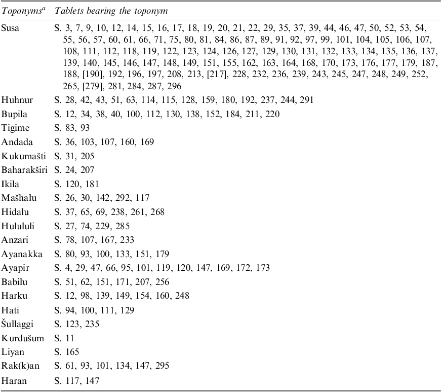
The SAT corpus provides a wide range of toponyms. In this corpus a total of 27 different toponyms have been counted (Basello Reference Basello, Álvarez-Mon and Garrison2011: 63).Footnote 6 Šušun (i.e. Susa), being attested 109 times, is the most frequently mentioned one. Other frequently mentioned toponyms are Huhnur, Hidali, Šullaggi, Kurdusum, and Anzar/Anšar (Basello Reference Basello, Álvarez-Mon and Garrison2011: 63).
Fortunately, studies conducted regarding these toponyms have been fruitful, resulting in the discovery of at least some suggestions concerning their location (Table 3). Considering the limited number of recognised settlements, Susa was probably the westernmost documented toponym.
the most notable toponyms in SAT corpus (Gorris Reference Gorris2020: 66, Fig. 3, Annex 3; elaborated by present authors)

Table 3: Long description
The table has two columns: Toponyms and Tablets bearing the toponym. The first column lists the toponyms, and the second column lists the tablets associated with each toponym. The table includes the following data: Row 1: Susa, S. 3, 7, 9, 10, 12, 14, 15, 16, 17, 18, 19, 20, 21, 22, 29, 35, 37, 39, 44, 46, 47, 50, 52, 53, 54, 55, 56, 57, 60, 61, 66, 71, 75, 80, 81, 84, 86, 87, 89, 91, 92, 97, 99, 101, 104, 105, 106, 107, 108, 111, 112, 118, 119, 122, 123, 124, 126, 127, 129, 130, 131, 132, 133, 134, 135, 136, 137, 139, 140, 145, 146, 147, 148, 149, 151, 155, 162, 163, 164, 168, 170, 173, 176, 177, 179, 187, 188, 190, 192, 196, 197, 208, 213, 217, 228, 232, 236, 239, 243, 245, 247, 248, 249, 252, 265, 279, 281, 284, 287, 296. Row 2: Huhnur, S. 28, 42, 43, 51, 63, 114, 115, 128, 159, 180, 192, 237, 244, 291. Row 3: Bupila, S. 12, 34, 38, 40, 100, 112, 130, 138, 152, 184, 211, 220. Row 4: Tigime, S. 83, 93. Row 5: Andada, S. 36, 103, 107, 160, 169. Row 6: Kukumati, S. 31, 205. Row 7: Baharakiri, S. 24, 207. Row 8: Ikila, S. 120, 181. Row 9: Mahalu, S. 26, 30, 142, 292, 117. Row 10: Hidalu, S. 37, 65, 69, 238, 261, 268. Row 11: Hulululi, S. 27, 74, 229, 285. Row 12: Anzari, S. 78, 107, 167, 233. Row 13: Ayanakka, S. 80, 93, 100, 133, 151, 179. Row 14: Ayapir, S. 4, 29, 47, 66, 95, 101, 119, 120, 147, 169, 172, 173. Row 15: Babilu, S. 51, 62, 151, 171, 207, 256. Row 16: Harku, S. 12, 98, 139, 149, 154, 160, 248. Row 17: Hati, S. 94, 100, 111, 129. Row 18: Ullaggi, S. 123, 235. Row 19: Kurduum, S. 11. Row 20: Liyan, S. 165. Row 21: Rak(k)an, S. 61, 93, 101, 134, 147, 295. Row 22: Haran, S. 117, 147.
a For a detailed list of Neo-Elamite toponyms, including those from SAT, see Gorris 2020: Annex 3. See also Vallat 1993, RGTC 11.
The discovery of an inscription at Tappeh Bormi published by B. Mofidi-Nasrabadi in 2005, whose existence had been notified by the members of the Iranian Cultural Heritage Organisation in Ahvaz, led to the recognition of another lost city mentioned in SAT, Huhnur (Basello Reference Basello, Tavernier, Gorris, Abraham and Boschloos2018: 237–238; Mofidi-Nasrabadi Reference Mofidi-Nasrabadi2005). In this inscription, Amar-Suena, the Ur III ruler, describes his triumph over Ruhuratir the Elamite deity and how he removed him (probably his statue) from Huhnuri and how subsequently he returned him to his city (Henkelman Reference Henkelman2008: 41; Mofidi-Nasrabadi Reference Mofidi-Nasrabadi2005: 163–164 §15, 169–170). Tappeh Bormi is situated some 4 km to the south-eastern side of Ramhormoz city. It is assumed that the size of the settlement in Middle and Neo-Elamite period was around 18.0 ha. Some unbaked clay tablets were found from this site, among which some Neo-Elamite tablets were attested (Basello Reference Basello, Tavernier, Gorris, Abraham and Boschloos2018: 237–238; Potts Reference Potts, Briant and Henkelman2008: 293; Wright and Carter Reference Wright, Carter, Abdi and Miller2003: 79).
Another mentioned toponym is Bupila, which according to Stolper should be situated in the neighbourhood of Susa (Basello Reference Basello, Tavernier, Gorris, Abraham and Boschloos2018: 238, no. 123; Stolper Reference Stolper, Harper, Aruz and Tallon1992: 268). This city was also mentioned in the Neo-Assyrian annals in connection with Kabinak and Dur-Undasi, two cities which might be recognised respectively as Haft Tappeh, ancient Kabnak (for more information concerning Haft Tappeh see Negahban Reference Negahban1991), and Chogha Zanbil (Basello Reference Basello and Mofidi-Nasrabadi2013: 3–4; Basello Reference Basello, Tavernier, Gorris, Abraham and Boschloos2018: 238; Parpola Reference Parpola1970: 93).
Hidali is another toponym mentioned in the SAT corpus. This toponym has often been accompanied by the epithet of qereb šadê, “in the middle of mountains” (Basello Reference Basello, Tavernier, Gorris, Abraham and Boschloos2018: 239; Gorris Reference Gorris2020: 159; Parpola Reference Parpola1970: 160–161), or in “distant mountains” east of Huhnur (Henkelman Reference Henkelman2008: App. 7.2). Traditionally Hidali has been situated at the proximity of Behbahan (Álvarez-Mon Reference Álvarez-Mon2004: 205–207; Hansman Reference Hansman1972: 103; de Miroschedji Reference Miroschedji1985: 274–275), but it has been questioned by Potts (Reference Potts2005: 173–175), since Behbahan is in a flat area, not compatible with the Assyrian epithet (Basello Reference Basello, Tavernier, Gorris, Abraham and Boschloos2018: 239). However, based on the PFT (Persepolis Fortification Tablets) evidence, Hidali was among the stops along the road from Persepolis to Susa (Fig. 4; Basello Reference Basello, Tavernier, Gorris, Abraham and Boschloos2018: 239; Henkelman Reference Henkelman2008: App. 7.2; Koch Reference Koch1986: 142–143).
The royal road under purview of the Persepolis administration according to Koch (Koch Reference Koch1986: 133 fig. 1)

One of the groups of individuals receiving a large number of weapons are the people of Zari, who were associated with a certain king named, Appalaya (S 80, 82, 108, 132, 236). Due to the semitic origin of this name, it is assumed to belong to a region west of Susa and probably could have been an Aramaean polity in southwestern Khuzestan (Álvarez-Mon Reference Álvarez-Mon, Tavernier, Gorris and De Graef2023: 277; Henkelman Reference Henkelman2008: 6).
Another settlement mentioned in the SAT corpus is Šullaggi, which is also mentioned in the PFT corpus. As proposed by Henkelman, this settlement is probably the same as Šalluku, mentioned in some Neo-Babylonian letters, and Seleucia on the Hedyphon. This city is identified by Hansman with the site of Jan-e Shin, roughly 35 km southwest of Ramhormoz. Given its location, one may assume that Šullaggi played a role similar to that of Hidali and Huhnur in contacts with the highlands (Basello Reference Basello, Tavernier, Gorris, Abraham and Boschloos2018: 239; Henkelman Reference Henkelman2008: 43).
Another toponym from the texts of Acropolis which is also mentioned in PFT corpus, is Kurdušum, which was a way-station probably in the western sector of the Fahliyān region, near Dašer (Basello Reference Basello, Tavernier, Gorris, Abraham and Boschloos2018: 239; Hallock Reference Hallock, Gibson and Biggs1977, 132; Henkelman Reference Henkelman2008: 503, fn. 1170). Koch identified this settlement with Ramhormoz, a stop on the road from Persepolis to Susa (Basello Reference Basello, Tavernier, Gorris, Abraham and Boschloos2018: 239–240; Koch Reference Koch1986: 144–145).
Interestingly, Anzar is another toponym attested in the SAT corpus that Hinz and Koch have proposed as referring to a settlement located in what would later become the province of Parsa, but Hallock proposed that it could be another name for Anšan (Basello Reference Basello, Tavernier, Gorris, Abraham and Boschloos2018: 240; Hallock Reference Hallock1969: 668; Hinz and Koch Reference Hinz and Koch1987: 67). In Fig. 5 the position of these settlements is highlighted, the rest of the mentioned toponyms are most probably scattered throughout Susiana, but their exact position is not clear yet.
The approximate location of some of recognised settlements, mentioned in SAT corpus

The important city of Liyan is also mentioned in SAT (Scheil Reference Scheil1907: 146). The location of this city, situated in coastline of Persian Gulf, is recognised as being the site of Tol-e Peytul (Pézard Reference Pézard1914; Potts Reference Potts, Miller and Abdi2003). Tol-e Peytul was excavated for the first time by M. Pézard in 1913 (Pézard Reference Pézard1914). From this site, brick inscriptions containing the name of Liyan, e.g. EKI 4c, have been found, which provide evidence for the identification of this ancient city.
Rak(k)an is the next notable mentioned city. This toponym which appears frequently in PFT and the textual and glyptic contexts suggest a location in the region of Persepolis (Henkelman Reference Henkelman2007: 232–233). There have been some attempts to identify the location of this settlement, e.g. suggesting the site to be located in Ramjerd by Sumner Reference Sumner1986: 23; Istakhr by Koch Reference Koch1992: 39; Zarqan by Arfaee Reference Arfaee2008: 43–44; but most recently Atayi suggested Kal Abdi in the middle of the southern edge of the Beyza plain to be a convincing candidate for the location of Rak(k)an (Atayi Reference Atayi2024: 27–28).
Haran, which is mentioned in two tablets of SAT, i.e. S. 117, 147, is a problematic toponym. Gorris by analysing different corpuses, i.e. SAT, Nineveh letters, PFT, and Assyrian and Babylonian references, suggests that Haran which is mentioned in SAT, can be connected with different locations (Gorris Reference Gorris, Tavernier, Gorris, Abraham and Boschloos2018), but most probably was a chiefdom in the Trans-Tigridian region, in the vicinity of Der, within the political power of Elamite kings (Gorris Reference Gorris2020: 127).
The tablets of Anšan exclusively reference the city of Anšan itself, where they were discovered, suggesting that the recorded transactions were limited to this location (Sajjadiyan and Makvandi Reference Sajjadiyan and Makvandi2024 Stolper Reference Stolper1984: 15), this demonstrates that all the transactions took place within the city, supporting the hypothesis that the institution’s transactions were internal, involving senders and recipients who were all workers of the organisation. On the other hand, the SAT corpus, as discussed above, presents a wide range of toponyms, spreading across the south-west of Iran, mostly the Susiana.
While studying this archive, one should bear in mind that the SAT corpus was solely involved in the distribution of weaponry to individuals or groups. This does not necessarily imply that all the mentioned locations and individuals were under the control of the palace’s power in Susa. Even if some of them were, this archive’s role was limited to the distribution and delivery of weaponry to them.
5.5 . Administrators in SAT
The Neo-Elamite Acropolis archive of Susa provides crucial evidence for understanding the role of administrative officials within Elamite economic and court systems. Among these figures, one of the most debated titles is the araš hutlak, an official responsible for registering commodities in the archive (S. 25: 9; S. 159: 6). The principal figure bearing this title was Kuddakaka (S. 285:7; Gorris Reference Gorris2020: 185), who appears to have served as the main araš hutlak during the production of the majority of tablets at Susa. Although multiple individuals with the same designation are attested, their authority seems to have been geographically dispersed across other centers such as Huhnur, Bupila, and Gisat (Waters Reference Waters2000: 94). Within the palace itself, however, the responsibilities of the araš hutlak appear to have been replaced by another functionary, the ragipal (S. 52; Gorris Reference Gorris2020: 185).
The exact meaning of the compound title araš hutlak remains debated. The term araš occurs in various professional designations and has been interpreted as “court,” or “granary” (Hinz 1952: 238–243; Hallock Reference Hallock1969: 670). Combined with hutlak (“storehouse messenger/herald”), the office likely denoted a high-ranking official, plausibly a senior storehouse manager or principal envoy (Henkelman Reference Henkelman, Lanfranchi, Roaf and Rollinger2003: 212). Other araš hutlak also appear in the Acropolis archive.Footnote 7 The araš-šá-ip may be understood as “foremen” or “chiefs” (S. 130, S. 153, S. 210), while the araš ginip functioned as “royal witnesses” in legal documents (MDP 11, 302–306; Gorris Reference Gorris2020: 185). The title araš nišgirra, attested for an individual named Kutup (S. 8:2), probably referred to a “keeper of the royal stores” (Henkelman Reference Henkelman2008: 26), although the fragmentary nature of the text prevents certainty. Kutup also bore the title araš-šahšikra (S. 105; S. 134), which has been interpreted as “royal cutter” or “court tailor,” linked to the distribution of garments (Gorris Reference Gorris2020: 186).
Taken together, the Acropolis archive illustrates a complex bureaucratic structure in which officials titled araš occupied diverse functions ranging from commodity registration and storehouse management to witnessing legal acts and supplying garments. The evidence highlights both the central role of figures like Kuddakaka in the functioning of the Susa chancellery and the broader diffusion of administrators with the designation of araš across the Neo-Elamite administrative landscape.
6. Conclusion
The SAT corpus represents the material remnants of the activities associated with an administrative archive, dated to the late 7th century and the first half of the 6th century BC. This archive’s texts predominantly focus on the allocation and distribution of various items, including weaponry, garments, and containers, to individuals originating from diverse locations. Such records provide valuable insights into the logistical operations and administrative structures of the period.
In contrast to the archive of Anšan, which dates to the end of the second millennium BC and reflects the internal transactions of an organisation, the SAT exhibits a fundamentally different scope and function. The Anšan archive appears to have been primarily concerned with intra-organisational activities, dealing with resources and management confined within a localized context. On the other hand, the SAT is distinguished by its broader geographical reach and outward-facing nature. Its documentation demonstrates the distribution of resources beyond the limits of the immediate administrative centre, encompassing an unprecedentedly vast territory. This shift underscores a significant evolution in administrative practices, pointing to a more complex and expansive network of interactions during this period.
The SAT corpus reflects a significant progression in the sophistication of the Elamite administrative tradition. This evolution is evident in the increasing complexity of the textual formulae and the greater quantity of documented information preserved within the archive. Such advancements indicate a deliberate refinement in record-keeping practices, reflecting the administrative system’s growing capacity to manage and track resources effectively.
Unlike the tablets of the archive of Anšan, where no explicit distinction is made between the roles or responsibilities of the recipients, the SAT corpus demonstrates a marked departure from this earlier simplicity. SAT explicitly identify the individual responsible for the allocation of materials, ensuring clarity in administrative accountability.Footnote 8 Moreover, the intended recipient is clearly specified, providing precise information about the transaction. This distinction underscores the development of a more structured and transparent bureaucratic framework, which likely facilitated the efficient management of resources and enhanced oversight within the administrative apparatus.
The date formula used in the SAT corpus shows continuity with earlier administrative practices, such as those observed in the archive of Anšan. In both archives, the month is consistently recorded as part of the date. However, while the Anšan archive includes both the month and the day, the SAT corpus exclusively records the month, omitting the day. Notably, in neither of these archives is there any reference to specific years.
This absence of year designations is particularly noteworthy and may provide insight into the nature and function of these archives. The lack of references to years suggests that the archives, particularly the Acropolis archive, were intended for short-term administrative purposes rather than as long-term one.
Excluding Susa and the problematic identification of Anzar, the majority of the recognized toponyms mentioned in the SAT corpus are dispersed throughout the mountainous regions situated to the east and southeast of Susiana. These toponyms are primarily aligned along the strategic route connecting Persepolis to Susa. However, the archive also documents settlements and groups of people located to the west and southwest of Susa. This geographic distribution highlights the extent of administrative reach and interactions across Susiana during this period.
It is essential to consider that this archive likely corresponds to the period following the devastating invasion of Susa by Ashurbanipal’s troops. In the aftermath of the Ashurbanipal’s military campaign, the central power in Susa appears to have played a pivotal role in distributing military equipment to individuals across various locations. Notably, these efforts included supplying tribes in the western regions of Susiana and the eastern Elamite cities, which they had common interests with. This distribution of military commodities can be interpreted as part of a broader strategy aimed at forging or maintaining alliances and treaties. Such actions suggest that the central authority in Susa was actively engaged in equipping neighbouring allied cities and tribes as part of a cohesive political and military strategy to secure its influence and stability in the region.
Abbreviations
PFT Persepolis Fortification Tablets
PTT Persepolis Treasury Tablets
SAT Susa Acropolis Tablets
TTM Texts from Tal-e Malyan




 Open access

