

1. Introduction
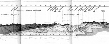
In 1878, Albert Heim (1849–1937) published a monograph on the anatomy of folds and the related mechanisms of mountain building based on what he had observed in the Glarus district of Mounts Tödi and Windgällen, an area where, in today's calculation, rocks aged between 250 and 300 million years overlie much younger rocks aged about 50 million years. On many levels, his book became a standard for the study of folded mountains. However, it introduced an interpretation which soon became the subject of extensive scientific discussion. Heim observed an impressive geognostic anomaly and claimed that the overturned rock strata were the remnants of what once had been two opposing recumbent folds of Verrucano rock enclosing a trough or syncline filled with the much younger Flysch rock (see fig. 1), a hypothesis first suggested by his teacher Arnold Escher (1807–1872).
Albert Heim's section through the eastern Glarus Alps, scale 1:100.000, N to the left. Note the dotted lines in the air and beneath the base line sketching the two recumbent folds which enclose a bag-like trough as extrapolated theoretically from the empirical data. The two shades of grey (orange and yellow in the original colored print) represent the different rock strata: the massive formation of the oldest strata, the Permian Verrucano, appears in the darker shade of grey, the Eocene bag (Flysch and related formations) in light grey. Between these two formations, hardly recognizable here, lies the Jurassic band of limestone (Comité d'organisation en vue de la VIe session, à Zürich. 1894. Livret-guide géologique dans le Jura et les Alpes de la Suisse dédié au Congrès géologique international. Lausanne: Payot, plate 7).

In 1884, the French geologist Marcel Bertrand (1847–1907) posited that a thrust fault, a single massive portion of the earth's crust that had pushed its way northwards, was far more plausible than the notion of the “double fold.” Heim not only ignored Bertrand's paper, but time and again he dismissed the critique voiced by anyone, colleague or friend, thus stirring up the most famous controversy in the history of Swiss geology. Only in 1901 did Heim accept the now-established thrust fault or “nappe” structure of the Glarus Alps and of other parts of the Alpine chain. Accounting for the late closure of the controversy, contemporaries and historians have either pointed out Heim's self-righteousness (Trümpy Reference Trümpy and Müller1991, 390) or his effort to keep the anomaly a regional phenomenon (Bailey Reference Bailey1939, 473; Masson Reference Masson1983, 58; Trümpy and Westermann Reference Trümpy and Westermann2008, 72–73, explain why Heim's interpretation was weak even by his own standards).
Bertrand suspected that the Swiss tended to see folds everywhere, an argument taken up and interpreted as disciplinary politics by the historian of geology Mott Greene (Greene Reference Greene1982, 205). In a similar vein, the article suggests that the controversy on the double fold lends itself to a closer examination of the long-term organizational patterns of Swiss geology, a subject rarely treated (but see Aeppli Reference Aeppli1915; Schaer Reference Schaer1994; Franks and Trümpy Reference Franks and Trümpy2005; Schaer Reference Schaer2007). Illuminating the internal workings of the discipline seems crucial if one seeks to understand how geologists supported the worthiness of their data and validated the conclusions drawn from them. The method of generalizing from their empirical findings was an important issue among geologists who struggled constantly with the immense scale that the circumference and age of the earth imposed on them (Greene Reference Greene1982, 12–15, 156, and 292–293; Secord Reference Secord1986, 28). Research on the profile of the earth's crust and the mechanisms of mountain building implied working and thinking about vast objects of study that were difficult to standardize or scale down in experiments. Swiss geologists employed in the service of the national geological survey, for instance, were each left with a region of about 3,300 square kilometers. Their numerous field trips ultimately only added up to “a more or less dense net of very fine, even invisible, lines” (Heim Reference Heim1878b, XI; for the field as a site of knowledge production, see Livingstone Reference Livingstone2003, 40–48). This article argues that early and middle nineteenth-century Swiss geognosy was shaped in genealogical terms and that the patterns of genealogical reasoning and practice worked to make generalizations of locally gained empirical knowledge.
Like nineteenth-century European geology as a whole, early Swiss geology was stamped by the semantics of family and descent. In the German speaking community, for instance, massive granite boulders lying in awkward isolation in the Swiss plain far from their point of origin in the Alps were called erratic blocks or “foundlings,” i.e. abandoned children of unknown parentage. Alexander von Humboldt spoke of “geognostic affinities” between rock strata (Humboldt Reference Humboldt1823, 300, “geognostisches Verwandtseyn” in the German edition). The logic of genealogy did not permeate only the conceptual level. Geology's institutional setting, brought into focus here, was also determined by the notions of family and inheritance. In this respect, the family-conscious noble descent of many savants obviously had its share in shaping their everyday lives, vocations, and habits (see Rudwick Reference Rudwick2005, 22–37, on the social structure of the international community). As in other social milieus, the sons often chose the career of their fathers.Footnote 1 There was, moreover, a sense of intellectual ownership attached to the geognostic territories under study. While planning a joint research project, geognosist Bernhard Studer from Berne (1794–1887) wrote to his Zurich colleague Arnold Escher: “I will leave the Alps in the small cantons of Glarus and St. Gall entirely to you. The territory has become your property through inheritance” (Archives of ETH Zurich ARETH, private papers A. Escher Hs 04:1694, Bernhard Studer to A. Escher, January 27th 1834). Studer's remark highlighted the fact that geognostic and stratigraphic mapping valued forms of intimate knowledge of the field: Authority in early geology was based on the geognostic understanding and steady ministration of a particular district. As both the object and site of research, the field was imbued with the ideas of territoriality and ownership – notions also belonging to the familial realm (see Secord Reference Secord1986, 7 and 30, on the territorial dimension of nineteenth-century geology). The sense of territorial property was enhanced by the national geological surveys. In Switzerland, the survey was established in 1860 (Aeppli Reference Aeppli1915, 82). It assigned the task of geognostic mapping to individual scientists according, largely, to the districts delineated by the sheets of the official topographical map thus adding a state-oriented, legalistic meaning to geognosists’ claims of ownership (for the history of the Swiss topographical map, see Gugerli and Speich Reference Gugerli and Speich2002). For his contemporaries, however, Studer also evoked the more general principle of social regulation through genealogical identification at work in early and middle nineteenth-century Europe. The right to own land, to practice a profession, or to study were legally determined by one's pedigree (for Prussia, see Eigen Reference Eigen, Heck and Jahn2000, 87; for Europe, Sabean Reference Sabean, Müller-Wille and Rheinberger2007; for Switzerland, Mathieu Reference Mathieu and Sabean2007). In the nineteenth century, family and its principle of inheritance were of general concern to many people and institutions. Natural and social sciences felt particularly attracted by the notions of generation and inheritance. Inheritance was seen as both a social institution and a biological process which secured the intergenerational transfer of property or properties (Müller-Wille and Rheinberger Reference Müller-Wille, Rheinberger, Müller-Wille and Rheinberger2007). The emergence of modern historical thinking around 1800 paralleled the discovery of “generations” as agents of historical change (Koselleck Reference Koselleck and Brunner1994; Parnes et al. Reference Parnes2008, 109–116).
In order to describe the genealogical organization of Swiss geognosy and explain its impact on the mechanisms of data validation and generalization, this article examines a particularly suitable case. During the nineteenth century, a genealogy developed connecting two fathers and two sons: Hans Conrad and Arnold Escher, Albert and Arnold Heim. In the case of the Eschers and Heims, the two families were related not by marriage but by blended intellectual and familial genealogies. Albert Heim saw himself as the rightful heir of his childless teacher, Arnold Escher. This constellation differed from the more usual case where the son took up his father's profession and inherited his chair or young scientists married the daughters of their academic teachers (Clark Reference Clark2006, 242–43; Baumgarten Reference Baumgarten1997; Niebuhr Reference Niebuhr1983). The case is particularly apposite for another reason. In different generations, the features of the Glarus Alps challenged established geological knowledge. The genealogical logic of early Swiss geology became highly visible but problematic, when research eventually turned, with Albert Heim, from Alpine geognosy to Alpine tectonics in the late nineteenth century. Tectonic research gained momentum as a mountain science, but at the same time it loosened the link between territorial knowledge and generalization from empirical data. As it turned out, the analysis of dynamic geological processes such as mountain building relied less on being intimately acquainted with the site in question than on comparing it with other structural features of the earth's crust. Albert Heim had difficulty in accepting the fact that generalizing from the local site in tectonics meant abandoning the idea of territorial uniqueness in favor of synthesis.
From Alpine Geognosy to Alpine Tectonics
Several fields of natural history converged to become the new science of geology around 1800 and afterwards. Besides mineralogy and physical geography, geognosy, as developed by Abraham Gottlieb Werner (1749–1817) at the Freiberg School of Mines in Saxony, was concerned with the distribution of the rock masses composing the stratified parts of the earth's crust. Encouraging empirical fieldwork, geognosy sought to interpret the local exposures of the sedimentary strata in terms of a general taxonomy (Secord Reference Secord1986, 29; Laudan Reference Laudan1987; Rudwick Reference Rudwick2005, 84–99): Werner and his disciples established a standard succession of the rock strata. It mirrored the original sequence of aqueous deposition according to Werner's neptunist idea of the primacy of water as an agent in the formation and alteration of the rock masses (Ospovat Reference Ospovat1967, 93). This geognostic order was represented in a tabular-textual arrangement, where the names of rock masses were numbered and clustered by means of lines or brackets or in the more figurative geognostic column depicting an idealized traverse section of the earth's crust (Rupke Reference Rupke1998, 62–70). Implicitly or explicitly, the original sequence of rock formations represented the periods of geological time with the oldest periods positioned at the bottom of the column and the most recent ones at the top. Moreover, geognosists worked on the premise that the earth's crust was characterized by an “underlying consistency and simplicity” (Secord Reference Secord1986, 28; von Buch [1810] Reference von Buch and Ewald1870, 86; Merian Reference Merian1867, 5). Difficulties in dating and ordering the rock strata arose because the actual tracing of beds from one area to another to establish their relative geognostic position was possible only to a limited extent. More often than not, the connections between different sites were missing or covered by soil. A formation could have been altered by erosion and by dislocations subsequent to sedimentation (Escher von der Linth Reference Escher von der Linth, Heer and Blumer-Heer1846, 53–54; Hedberg Reference Hedberg1965, 99). It could be locally incomplete or lie in rocks of varying types from place to place. The question was raised whether the same type of rock might be part of different formations. Moreover, the geognostic column continued to grow. Werner's so-called secondary or sedimentary formations were further subdivided and supplemented by a whole set of superimposed younger strata, the tertiaries. In the 1800s, geognosy started to embrace the idea of dating rock strata by the distinctive fossil remains they contained.Footnote 2
The mountainous Swiss landscape challenged correlation with the stratigraphic order of superposition being established in England, France, and the German lands. For about three decades, the geognosists failed, for instance, to make order out of the chaos of the many types of limestone rock beds in the Eastern Alps (Studer Reference Studer1825, V–XVII; Studer Reference Studer1827, 4; Studer Reference Studer1834, IV–VIII). When, in 1836, Bernhard Studer and Arnold Escher finally published a first, in their view, reliable geognostic table of the Eastern Alps, they reminded their colleagues of the as yet unanswered question: How to account for the dynamics which had so badly distorted the structure of the Alps (Studer Reference Studer1836, 696)? Considering that the stratigraphic column gave an idealized and, above all, static picture of the earth's crust nowhere to be found in the Alps, they felt the necessity of exploring the postdepositional disturbances of the stratified rock masses which had led, together mainly with erosion, to the present profile of the mountain range (Studer Reference Studer1834, VI; Rudwick Reference Rudwick1976, 170; Gohau Reference Gohau2003, 88). Inevitably, therefore, the features of the Alps called geologists’ attention to the dynamic forces operating in the earth's crust.
The notion “tectonics,” first introduced to the German speaking public by Carl Friedrich Naumann, pointed to these dynamic forces (Naumann Reference Naumann1850, 899; for the conceptual history, see Borbein Reference Borbein1982). From the beginning, tectonics was characterized by a global perspective (Greene Reference Greene1982, 88). The overall idea of a cooling earth core, hence a shrinking or sinking earth crust as held by the influential French geognosist Jean-Baptiste Armand Louis Léonce Elie de Beaumont (1798–1874) led to the dominance of “vertical thinking” in early tectonics. The plutonic upheaval of mountain chains along their axes, comparable to volcanic activity, as established by the Prussian geognosist Leopold von Buch (1774–1853) in his crater-of-elevation theory, complemented the picture of upwards and downwards movements in the process of mountain building (Greene Reference Greene1982, 69–121).
Research in mountain building came to center on the Alps. Understanding the structure of the Alps in its entirety was seen as a major contribution to solving the more general question of how to account for the shape of the earth's crust as a whole (ibid., 146). By 1875, a new tectonic idea emerged – sketched out first by Eduard Suess of Vienna (Origin of the Alps) and then expressed in more detail by Albert Heim of Zurich (Mechanism of Mountain Building). Both held that the Alps had been piled up due to horizontal compression or tangential forces and not uplifted by vertical forces. Together with Suess, Heim initiated a new epoch of “almost feverish activity” in geology, the epoch of “modern tectonics” (Mathews Reference Mathews and Mathews1927, 139–141; Greene Reference Greene1982, 194–95). As indicated above, debates in Alpine tectonics centered on either folds or overthrusting faults, “nappes,” as the basic unit of Alpine mountain building.
2. Hans Conrad Escher: Aligning Family Matters with Scientific Matters
Hans Conrad Escher (1767–1823) was an eminent savant and politician of Zurich. His career spanned four political regimes, the late years of Ancien Régime, the short-lived Helvetic Republic, the equally short epoch of Mediation, and the period of Restauration ending in the 1830s. Hans Conrad was born into a wealthy patrician family of Zurich with a tradition in state administration (Hottinger [1852] Reference Hottinger1994; Wolf Reference Wolf and Wolf1862; Meyer von Kronau Reference Meyer von Kronau1877). The family fabricated silk, and its trading company was based in Zurich. Among his contemporaries, Hans Conrad was known as a most adept geognosist who was said to “know the Swiss Alps like the back of his hand” (Hottinger [1852] Reference Hottinger1994, 377; see also Studer Reference Studer1825, XXII; Wolf Reference Wolf and Wolf1862, 335 and 341). He prepared the ground for the familial organization of Swiss geognosy following the cultural patterns and social paths of his time and milieu. He aligned family matters with geognostic matters. As will become clear, he did so by choosing the public good as a guideline that determined all his endeavors. With respect to material culture, his creation of a family archive established the closeness of both realms.
The enlightened concept of education, as elaborated in and near Zurich by Heinrich Pestalozzi or Philipp Emmanuel von Fellenberg (Guggisberg Reference Guggisberg1953; Silber Reference Silber1960), and the idea of generations being dependent on each other for achieving moral, political, and economic progress articulated Hans Conrad's self to his family and to the society as a whole. The newlywed considered, for instance, recurrent self-examination to be helpful while living up to his new role as paterfamilias and citizen. In 1790, he resumed, with his wife already pregnant, the custom of keeping a “sincere diary” that complied with the educational program set forth in the Secret Journal of a Self-Observer, published in 1771 by his friend's father Johann Caspar Lavater (Escher Reference Escher1998a, 492; Wolf Reference Wolf and Wolf1862, 320; Guggisberg Reference Guggisberg1953, 163). As a member of the “Helvetic Society,” a Republican association of free-thinking intellectuals, Hans Conrad engaged in promoting individual perfection and society's improvement within the existing political system (Hottinger [1852] Reference Hottinger1994, 230; Meyer von Kronau Reference Meyer von Kronau1877, 366; Zimmer Reference Zimmer2003, 43–79). He felt that the task of a paterfamilias was to secure the happiness of his family by applying himself to benefit the public. He took the happiness of his children to be the remuneration for his political commitment in the name of the public good (Escher Reference Escher1998a, 764 and 771; for the gender-biased concept of the paterfamilias, see Koschorke Reference Koschorke2000, 151–157). Holding executive powers during the Helvetic Republic, the field of expertise Hans Conrad most willingly delineated for himself was teaching and educational politics. Time and again, the rapidly changing political regimes entrusted him with organizing the institutional settings necessary to offer young boys the foundation required to engage in political and commercial affairs (Escher Reference Escher1998a, 587, 744, 758, and 776; Wolf Reference Wolf and Wolf1862, 330). He became famous, however, for linking Alpine geognostic knowledge to hydrotechnical landscape engineering which saved the agricultural region adjacent to the Glarus Lake Walenstadt from regular flooding and its population from continual illness and poverty. Escher's redirecting of the Linth River, a major public construction work realized from 1807 to 1823, was hailed as a patriotic act fostering political unity and economic improvement among the Swiss cantons (Speich Reference Speich2002).
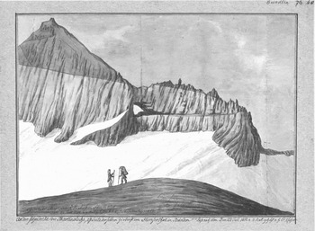
Among his scientific achievements, the adoption of the Wernerian geognosy for exploring the Swiss Alps stood out. In 1794, Escher praised “Werner's system” as the first truly “scientific” system (Escher Reference Escher1998a, 578 and 591; Hottinger [1852] Reference Hottinger1994, 371). Together with Leopold von Buch, his efforts were directed towards gathering and documenting Swiss empirical data compatible with the ongoing European debate. Hans Conrad first gave a geognostic description of the “curious rock formation” (Escher Reference Escher1809, 345) dealt with later under the heading of the “double fold” (see fig. 2). Whereas the irritating fact of horizontally bedded strata of limestone superimposed on steeply tilted strata had been noticed before (Zurlauben and Laborde Reference Zurlauben, Dominique and de Laborde1780, LX–LXI; see Hutton Reference Hutton1795, 419), he suggested the actual inversion of the established order of the strata. Targeting distinct audiences, Hans Conrad lectured about his travels and readings and acquainted the Zurich public with the science of geognosy (Escher Reference Escher1998a, 640, 565, 576, 591, and 669).
Drawing of Hans Conrad Escher entitled An der Scheidecke des Martinslochs, Ostseite derselben zuoberst im Flimserthal, Pass nach Elm den 22. Juli 1812. This natural outcrop is to be found in fig. 1 as the first Verrucano peak of the northward looking fold, left of Sardona peak (Courtesy Graphische Sammlung der ETH, Zurich, call number HCE A IX 180a).

Alpine geognosy was not only part of what future state officials ought to know; pursuing naturalist and geognostic knowledge on field trips was also seen as a patriotic duty and, through, among other things, the sublime experiences of nature, was considered a medium of self-education. Thus alpine geognosy mirrored the objectives hoped for with regard to the “Swiss tour,” a young Swiss gentleman's educational travel in Switzerland established in the eighteenth century (Hettling et al. Reference Hettling1998, 9–12). Honorace Bénédict de Saussure's writings, for instance, resonated with these aims and were part of a boy's upper-class education. Hans Conrad had read and excerpted the savant's Voyages in the Alps (1779–1796) and his reading of de Saussure resonated not so much perhaps with his scientific work as with his personal memoirs. These contained, for instance, a vision Hans Conrad had at Mount Nollen near the Grimsel hospice: The history of the earth's crust was unfolding in front of his mind's eye, an episode which was reminiscent of the famous revelation that de Saussure had while contemplating the vista from the peak of Mount Cramont (Escher Reference Escher1998b, 49 and 71; Escher Reference Escher1998a, 582). Hans Conrad gave his story a moral twist entangling, in the name of the public good, his roles of paterfamilias and savant. The geological insights he gained on the mountain had provided him, he noted, with the intellectual strength and renewed energy needed to deal with his political duties down there in society.
A second point illustrated the unity of Hans Conrad's scientific, family, and political life: When he returned from his travels, Hans Conrad tagged and cross-referenced the specimens he had collected. He elaborated his notes and sketches from the travel diary. Traverse sections, panoramas, or geognostic accounts were produced at home. This desk-work fitted well into his more general writing habits characterized by correlating different constitutional drafts and other political programs with excerpts of treatises on state sciences or cameralistics, preparing and comparing cantonal statistics, or proposing syllabi (Hottinger [1852] Reference Hottinger1994, 374; Escher Reference Escher1998a, 586; see also Hamm Reference Hamm1993). They also fitted into his working routines framed by the family household. Geognostic studies occupied the early morning hours before having breakfast with his family, spending the rest of the morning at managing the family company, and the afternoons and evenings with political studies and official duties. He did not neglect his family though, as he was keen to underscore. He depicted himself studying with his youngest daughter on his lap or walking her around while reading a scientific paper (Escher Reference Escher1998a, 592). Every sketch, outline, and report ultimately became part of the family archive. His genealogical impetus was evident. Already the diary of the father-to-be was thought to “perhaps be instructive to a worthy son” (ibid., 493). The son, Arnold, was finally born 17 years later in 1807. Hans Conrad considered his memoirs, started in 1812, to be another source of private life which might be useful to his son, and perhaps, as Lavater did, even to historians (ibid., 11 and 757; Lavater Reference Lavater1773, XVIII). As early as 1817, Arnold Escher accompanied his father on his travels (Escher Reference Escher1998a, 793). The first trip took them to the Linth River, along the tourist-friendly Clön Valley, and over the Pragel Pass connecting cantons of Glarus and Schwyz. From 1821, the father set out to teach his son “natural sciences and natural history” (ibid., 809). Hans Conrad Escher died in 1823. In his testament, he advised the 16 year-old Arnold to follow his suit and seek a double career in life (ibid., 817). Besides studying the natural sciences in Geneva and at German universities, Arnold was counseled to learn the technicalities of silk fabrication and commerce in textiles.
3. Arnold Escher and the Figure of the Heir
Arnold Escher took center stage in the familial organization of early Swiss geognosy. He accepted and cherished his father's legacy. He continued to study the Glarus anomaly described by his father and came up with a tectonic interpretation in accordance with his research on the folded strata abundant in the Eastern Alps. By considerably augmenting the family archive with geognostic notes and drawings he also created the need for an heir: His scientific work needed to be translated and edited by somebody.
His father passed on to him all the distinctions he had been awarded for his hydrotechnical achievements in the lower Linth Valley (ibid., 815). Most importantly, Arnold was entitled, by patrilineal inheritance, to carry the epithet “von der Linth” which the authorities of Zurich bestowed upon Hans Conrad posthumously in 1823. He inherited his father's professional contacts and reputation: While studying in Berlin from 1827 to 1829, he had immediate access to the most distinguished scientific circles where he associated with Leopold von Buch, Alexander von Humboldt, and others (Gümbel Reference Gümbel1877, 362). He inherited his father's diaries, scientific notebooks, correspondence, notebooks, maps, drawings, and his mineralogical collection: 1,430 pages of manuscript text, 900 drawings, and about 10,000 rock specimens (Hottinger [1852] Reference Hottinger1994, 375). And even though his father was considered to be a founding figure of Swiss geognosy in general, Arnold inherited the Glarus Alps and their adjacent regions as his particular research object (Gümbel Reference Gümbel1877, 363 and 364; Heer Reference Heer1873; Désor Reference Désor1872). Various reasons accounted for it. Scientific Zurich reclaimed the nearby Glarus Alps as its natural territory of exploration. His father's engagement with the Linth River scheme made him spend a lot of time in and near the Glarus Alps whose debris was causing the problems in the Linth Valley. Moreover, the debate on distinguishing and classifying different types of Alpine chalk had its origin in the description of the traverse sections of the Glarus und Sernft valleys. Arnold himself chose the St. Gall and Glarus Alps as his territories, a choice which was institutionalized in 1860, when he was commissioned to survey the geology of this area of the Swiss map.
Arnold continued to do fieldwork in the Glarus Alps (Escher von der Linth Reference Escher von der Linth1841). In 1846, he described a thin band of “metamorphosed limestone” lying everywhere between the Sernf slates or “Verrucano” (Studer Reference Studer1853, 183) and the formations of Flysch and Nummulites (Escher von der Linth Reference Escher von der Linth, Heer and Blumer-Heer1846, 68ff.). The Verrucano contained no fossils, but as a geognostic regularity, was overlain by rock strata which could be determined as Lower Jurassic. Therefore, it could be defined as “the most ancient rock of the region” (Murchison Reference Murchison1849, 200). Arnold's friend Louis Agassiz dated the Flysch, based on his studies of the fossil fishes they contained, first as Upper Chalk and later as Lower Tertiary (Studer Reference Studer1825, VII; Murchison Reference Murchison1849, 199; Marcou Reference Marcou1896, 15). In 1848, the eminent Victorian geologist Roderick Impey Murchison traveled with Escher in the Glarus Alps and was shown the overthrust at Pass Segnes. Upon his return, he reported at a meeting of the Geological Society that “the strata had been inverted, not by frequent folds like in the Hoher Sentis . . . but in one enormous overthrow” (Murchison Reference Murchison1849, 248). Folds were a typical feature of the Eastern Alps. Escher had first studied them systematically on Mount Sentis, a district adjacent to the region of the Glarus Alps “rendered classical in geology by the recent labours of M. Arnold Escher de Linth” (ibid., 200; Heim Reference Heim1896, 11). Both the Sentis folds and the Glarus overthrow prompted Escher and Murchison to debate on the problem of “movements”, i.e. the dynamics of mountain building (ARETH, private papers A. Escher Hs 04:1327 Murchison to A. Escher, November 29th 1848). By the mid 1860s, Escher opted for a more local solution that did not have to invoke the “miraculous” (Murchison) overthrow. Instead of defining a single thrust from the south stretching over the whole canton, maybe even “extending to the canton of Berne,” he inferred two recumbent folds, one from the south and one from the north, facing each other. In between and beneath, the youngest Flysch rock filled a bag-like trough (ARETH, private papers A. Escher Hs 04s:237, Notizen für Vorlesungen, Bau u. Entstehung der Gebirge, pag. 206; Escher von der Linth Reference Escher von der Linth1866).
The institution of textual tradition linked familial and scientific genealogical practices. While the written remains of the fathers constituted the family archive, the earlier published results or unpublished manuscripts and notes constituted the state of the art from which any new scientific research started. Arnold cherished his father's legacy by editing some of Hans Conrad's travel accounts (Escher Reference Escher1836; Gümbel Reference Gümbel1877, 364). He paid him homage in a popular and bestselling biography of Hans Conrad. As the result of a time-consuming archival stocktaking, he depicted his father's extensive knowledge of the Swiss Alps. On a topographical map of Switzerland, he charted every tour Hans Conrad had made and marked every vantage point from where his father had drawn a panoramic view (Hottinger [1852] Reference Hottinger1994, foldout between pp. 400 and 401). Arnold appropriated the knowledge compiled by his father through comparing Hans Conrad's data with his own empirical findings gathered during field trips. In doing so, he studied his father's methods and routines of note taking, drawing, and referencing. Arnold adopted, for instance, Hans Conrad's habit of not commenting “on possible interpretations of the observations made” (ibid., 374–75). It was common lore that Arnold, compared to his extensive research, hardly published (Heer Reference Heer1873, 264–267; Gümbel Reference Gümbel1877, 363). By the early 1830s, Bernhard Studer, ten years older than Arnold and a student of von Buch (Gümbel Reference Gümbel1893, 731), was his closest scientific collaborator and friend. They practiced a division of labor. Studer composed the text of their geognostic monographs, elaborating on the parts Escher had investigated on his friend's fieldnotes (Studer Reference Studer1835, 52; Studer Reference Studer1869, 2). Escher, in turn, produced the traverse sections and maps. Studer managed to do justice to both fairly new formats of geognostic writing, the serialized communication of results via journal articles as well as the “exhaustive” examination of a particular region or formation documented in a lengthy monograph (Studer Reference Studer1834, IV; Wolf Reference Wolf and Wolf1862, 342; Stichweh Reference Stichweh1994, 164; Cantor and Shuttleworth Reference Cantor, Shuttleworth, Cantor and Shuttleworth2004). Escher, in contrast, struggled with any form of publishing. Typically, he circulated his geognostic findings among his colleagues who, in exchange, took on the work of correlating and fitting the data into the larger picture. That way, data was made public which “would have otherwise been buried in his manuscripts” (Gümbel Reference Gümbel1877, 364). After his tour in the Glarus Alps, for instance, Murchison confirmed this arrangement: “In the section of Switzerland, I will do my best to confer to you the honor you so strongly deserve” (ARETH, private papers A. Escher Hs 04:1327, Robert I. Murchison to A. Escher, November 20th 1848; Heer Reference Heer1873, 266–67). Studer put it like this: In Escher's mind, the challenge of organizing the outline of a monograph “piled up a mountain more difficult to surmount than all the passes of the Glarus” (ARETH, private papers A. Escher Hs 04:1720, Bernhard Studer to A. Escher, July 17th 1837). He did not accept his friend's excuse that more knowledge was still needed about the rock strata and their bedding: Without a first draft at hand, Escher could never define his empirical lacunae. In order to get his friend to write, Studer employed various strategies. He taunted him in publications (Studer Reference Studer1827, 4) or flattered him in letters: “Your traverse section of our Grisons tour is so beautiful,” Studer wrote in December 1833, “that I can hardly resist sending it . . . to Leonhard [editor of Neues Jahrbuch für Mineralogie, Geologie und Paläontologie]” (ARETH, private papers A. Escher Hs 04:1693). Often enough, he simply reported on faits accomplis: “Your traverse section of the Spratten . . . will, mildly annotated, appear in Leonhard's journal” (ARETH, private papers A. Escher Hs 04:1695, Bernhard Studer to A. Escher, June 13th 1834). Escher mostly worked in the semipublic sphere of letter writing, conversation, traveling in companionship, and teaching (Gümbel Reference Gümbel1877, 363). Since 1834, he lectured on geognostic subjects at the newly founded university of Zurich; in 1856, he was appointed the first professor of geognosy at the new Polytechnic.
4. Albert Heim's Entangling of Familial and Intellectual Genealogies
Albert Heim practiced the science of Alpine geognosy and tectonics as a family business. In families, thinking in terms of generations permitted either highlighting the act of procreation or joining the narrative of descent. In science, the semantics of generation translated not into procreation but creativity, on the one hand, and legitimate affiliation, on the other. Whereas the Eschers had given the familial organization of Swiss geognosy a natural outlook, Heim's claiming to be the actual heir of Escher's scientific legacy was in need of naturalization. Entangling the familial and intellectual genealogies was a way to naturalize his claim.
Arnold Escher had been a bachelor for many years. Only in 1857 had the Protestant been allowed to marry Maria Barbara de Latour (1807–1863) from the Catholic part of Grisons, whom he had known for a long time (Theus-Bieler Reference Theus-Bieler2001, 24). The late marriage bore no children. The role of a bachelor and childless husband, troubling to the genealogical logic, was a fixture in family novels of the nineteenth century: As a near-relative, the childless man would inspire his godson, nephew, or a young friend (Parnes et al. Reference Parnes2008, 150–187). Quite comparably, Escher acted as Heim's mentor from the moment they had met, in 1863, in the Zurich section of the Swiss Alpine Club (Zentralbibliothek Zurich, papers A. Heim XIX 18, Rede zum 50 jährigen Jubiläum der Sektion Uto SAC). Escher was Heim's professor during his studies at the Zurich University and Polytechnic from 1866 to 1869. From 1868 on, Albert Heim accompanied his teacher on summer excursions to the Tödi district, the highest peak of the Glarus Alps where Escher lately worked on the map sheet XIV of the Swiss geological survey (Heim Reference Heim1878b, V; Heim Reference Heim1929, 217). When Escher died in 1872, Heim was assigned to replace him and was handed over the collections of specimens, drawings, and notes (Heim Reference Heim1878b, 5).
Escher's childless marriage made it easy for Heim to build imaginary familial ties. Escher willed his scientific papers and collections to “his hometown [Vaterstadt]” (Gümbel Reference Gümbel1877, 363). Heim could feel as if Escher's archive was passed on to him personally though: At the age of 23, Heim was appointed Escher's successor as professor of the Federal Polytechnic in Zurich. The office made him also director of the school's natural history collections where Arnold's, and also Hans Conrad's, notebooks and specimens were reposited. Heim kept the only key to the cabinets (ARETH, papers natural history collection, Hs 1080:17, pag. 2, Regulativ, welches die Benutzung des Escher'schen Nachlasses ordnet, §1). Although The Mechanism of Mountain Building differed a lot from his teacher's notes, Heim maintained that “with respect to the observational facts laid out in the monograph, I merely acted as Escher's editor” (Heim Reference Heim1878b, 5 and 129). The hermeneutic and geognostic desk-work was worth mentioning because it underscored Heim's position as an heir. By studying Escher's fieldnotes “in the same way” he studied the Alpine nature, Heim confirmed the idea of the Glarus Alps as an inherited territory (ibid., 218). He inferred that the corpus of texts, drawings, and specimens was a mirror image of his territory, as difficult to decipher as the natural phenomena themselves. Once its analysis and interpretation were achieved, however, the new understanding would, by implication, also apply to the Glarus Alps. And vice versa: Once the inherited territory was fully understood, the task of learning to read the family papers was accomplished. This task was, to refer once more to the condensed reality of nineteenth-century family novels, an established literary trope (Stifter [1868] Reference Stifter1997, 23). The challenge was to grasp the sense of it all which meant, for scientific fieldnotes, to articulate what had as yet been untold insights and unrealized conclusions. Due to his privileged access to the materials and intellectual closeness to his teacher, Heim claimed to present the “true exegesis” of Escher's geognostic and tectonic work on the Glarus district (Heim Reference Heim1878b, 128). Having examined and interpreted the “local evidence” Escher had found in the Glarus Alps, he “could just not arrive at dissenting conclusions” (ibid., 219). Heim confirmed the hypothesis of the double fold.
5. The Glarus Double Fold as a Physical Model of Mountain Building
To come back to creativity: The idea of inheritance, associated with generational change, not only established continuity but also signaled a new beginning. After all, Heim had made a tectonic study while being assigned to geognostically and stratigraphically “color” a sheet of the Swiss topographical map, a shift he readily admitted in the preface of the Mechanism (ibid., 5). The geological map sheet XIV eventually appeared in 1885. His study of 1878, however, was not included in the series of monographs which came along with the maps and provided the empirical data depicted on them. According to Heim, the study had been rejected by the geological commission of the Swiss Society of Natural Sciences because it was, due to the many illustrations, too expensive to publish and too specialized to fit into the series (ibid., V). The tectonic approach, advocated at length in the Mechanism, did not meet the editors’ idea of complementing the visual language of the geological map. The disciplinary shift Heim had taken – fueled by ongoing if isolated discussions, and even more so, by Escher's next to absolute silence in terms of publishing on tectonic theories – had already started to irritate the normal organizational course of Swiss geology.
Eager to mark progress, Heim aimed at upgrading Escher's hypothesis of the double fold by making it the explanatory core of his theory of mountain building (similarly Greene Reference Greene1982, 198; for a reappraisal of the study's achievements, see Milnes Reference Milnes1979). The view that folding accounted for mountain building on all scales was what he took as being Escher's scientific legacy waiting to be formulated as a general theory (Heim Reference Heim1929, 218). By adding the language of modeling and the method of microscopy to the territorial principles of geognostic knowledge production, he made the double fold the creative solution to Alpine tectonic problems. Heim's break with traditional geognostic reasoning about the Glarus Alps consisted in interpreting the hypothetical object of the double fold as a physical model on the scale of 1:1 which demonstrated the mechanisms of crustal deformation by lateral pressure. The model did not capture “the earth's capacities on human scale” as did the mimetic scale models geologists built around that time (Oreskes Reference Oreskes, Creager, Lunbeck and Wise2007, 93): In the year Heim published his Mechanism, Alphonse Favre from Geneva, for instance, placed a layer of clay on a sheet of stretched rubber which was allowed to resume its original dimension in order to imitate “the formation of the great inequalities of the earth's surface” (Favre Reference Favre1878; Anonymous 1878, 103). In contrast, Heim described the double fold as a model set up by nature. According to Heim, it was exemplary in that, for once, nature revealed the workings of crustal deformation by relocating the process from the earth's interior to its surface (Heim Reference Heim1878b, 239–240). Heim did not mean to imply that the inner strata of the earth's crust were composed of many more double folds: The relocation had entailed changes in the features and structure of the deformation process.
Why did the geognostic and stratigraphic details of the Glarus double fold plausibly “stand in” for the general mechanism of mountain building? Heim argued that the double fold was, in terms of compensation for the shrinking surface of the earth, the functional equivalent to the central zones of crystalline or granitic rocks positioned along the axes of the Alpine chains, the “central massifs” (ibid., 239). The term had been introduced by Studer with reference to von Buch's “central craters of elevation” (Pfannenstiel Reference Pfannenstiel1948, 98). The double fold offered the unusual opportunity to see and measure the process of “contraction by up-folding”: “Instead of developing in the depth of the earth, [the folding process] had turned to the outside taking the form of the [Verrucano] overthrust” (Heim Reference Heim1878b, 239–240). In Heim's view, the granites of the central Alps corresponded to “a system of most intense folding,” “mechanically generated” in the earth's interior. At a depth from 2000 to 6000 meters, Heim explained, high pressure made rocks ductile enough to move without shattering (Heim Reference Heim1878a, 92). Studying crystalline rock specimens under the microscope, Heim had found startling evidence. Elongated pebbles of crystalline rocks enclosed in younger rock masses showed that the crystalline central massifs had been deformed and passively dislocated long after their formation. They were not themselves the uplifting agent which had pushed away the sedimentary rocks (Heim Reference Heim1878b, 239) as held by von Buch's crater-of-elevation theory.
Yet another aspect was important to Heim. The hypothesis of the double fold as a model on the scale of 1:1 maintained the territorial integrity of the Glarus Alps as a field of research. The model was wholly enclosed within the boundaries of the Glarus Alps as studied by Escher. In other words, textual tradition and territory, the two aspects of one legitimate inheritance, did not fall apart. Geognostic or stratigraphic knowledge validation demanded this congruence. In order to strengthen his findings, Heim would not give up the source of scientific authority on which the familial organization of geognosy relied. He thought himself well advised to consolidate the new tectonic approach in Alpine geology by sticking to the traditional forms of authority.
6. The Double Fold Contested
This strategy, however, proved to be counterproductive due to the disciplinary shift during the 1870s and 1880s. Heim's model was challenged in the ensuing scientific controversy on the reality of the double fold. Tectonics gained a theoretical dimension which abstracted from the territorial logics of geognosy. By implication, the unity between the geognostic description of a district passed on in notebooks or publications and the intellectual property claims of an inherited territory dissolved.
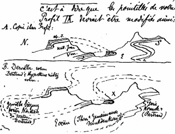
Why assume two folds in the first place? Marcel Bertrand, an engineer of the Corps des Mines working for the French geological survey, was suspicious about the almost perfect symmetry the double fold exhibited. He wondered why Heim had opted for a radical rupture between strata (two folds) whose characteristics and position might equally suggest one continuous overthrust (Bertrand [1890] Reference Bertrand1908, 201). In 1884, he explained that French geologists immediately thought of faults instead of a “compressed and stretched fold” when looking at the evidence presented by Heim's sections, particularly at the clear-cut interface of the small band of Jurassic limestone. Bertrand inferred, just as this article does, that an affinity with determining folds biased the perception of the Swiss working in the Eastern Alps (Bertrand Reference Bertrand1884, 319). Bertrand, who had never been to the Glarus Alps, suggested dismissing the fold as the indispensable basis for all lateral movement when he reinterpreted Heim's findings by comparing the Glarus Alps to the region of the Belgium coal basins. He underscored the similarities of the two regions and disputed the character of the double fold as a unique model of mountain building. In an interesting test, he composed a succinct geological description applicable to both regions without changing a single word (ibid., 322–323). The French geologist Emmanuel de Margerie dealt with the subject in a letter to Heim (see fig. 3). “Bertrand has never been in Switzerland. So he exclusively draws on the facts you established in your book,” he diplomatically explained. “He does not question the observed facts but only their interpretation. He deals with the directions of the dotted lines, either in depth or in the air, connecting what is separated today mostly because of erosion” (ARETH, Hs 400:203, E. de Margerie to Albert Heim, Paris, March 30th 1885, 2; emphasis in the original). Bertrand's and de Margerie's sketches demonstrated what was at stake in Alpine tectonics and how the idea of “nappes” emerged (see Masson Reference Masson1976; Sengör Reference Sengör and Miyashiro1982; Greene Reference Greene1982, 192–220; Trümpy Reference Trümpy and Müller1991). In order to describe the tectonics of a mountain range, geologists had to conclude from fairly diverse surface evidence which combined the outcrops and geognostic or stratigraphic details into the larger conceptual hypotheses they advocated. As a consequence, their visual language evolved towards theoretical sections (Rudwick Reference Rudwick1976, 178 and 180). The way of filling in the blanks of these sections were theoretical extrapolations fueled by efforts of global synthesizing, a skill which Eduard Suess, the renowned professor from Vienna, and his monographs Origin of the Alps of 1875 and The Face of the Earth, appearing in installments since 1883, seemed to perfectly embody (Bertrand Reference Bertrand, Suess and de Margerie1897, 6; Henning Reference Henning1937, 787; Sengör Reference Sengör and Miyashiro1982, 17; Durand-Delga and Seidl Reference Durand-Delga and Seidl2007).
In a letter to Heim of 1885, Emmanuel de Margerie sketched out Heim's double fold and Bertrand's thrust fault (Courtesy Archives ETH, Zurich).

Meanwhile, Heim worked hard to preserve and revitalize the territorial dimension by maximizing the stream of visitors to the Glarus Alps. In 1890, he guided the German Geological Society to the Glarus Alps in order to win over the participants and end the controversy. His colleagues, however, would testify “only to the empirical observations made” and refrained from backing Heim's tectonic conclusions (Zentralbibliothek Zurich ZBZ, private papers Albert Heim VI, Friedrich Penck to A. Heim, January 14th 1891; see also Heim Reference Heim1882). They deplored the fact that Heim had worked exclusively in the Glarus Alps and did not compare his findings with other sites (Arbenz Reference Arbenz1937, 335). Tellingly, in 1906, Eduard Suess credited Heim and Escher for “providing a detailed geognostic picture of the Glarus Alps which strongly suggested, when compared to other regions, the sweeping conclusions” drawn about Alpine tectonics (ZBZ, private papers Albert Heim VI, Eduard Suess to A. Heim, September 27th 1906).
Baptizing his son after his teacher Arnold, in 1882, could be seen as an attempt to stabilize the territorial and familial patterns of Swiss geology. It was a symbolic act because Heim had determined his son's future from birth. Arnold was to become his father's successor in the Zurich chair as a note on one of Arnold's very first childhood drawings documented (ARETH, private papers Arnold Heim, Hs 495a:34). Heim reaffirmed his plan on various occasions, for instance the year Arnold received his doctorate (ARETH, private papers Arnold Heim, Hs 495:742, Albert Heim to A. Heim, November 5th 1904). Heim prepared the ground for generational progress, and Arnold's dissertation is a case in point: It was a contribution to the geological survey map and monograph of Mount Sentis which Albert Heim published in 1905. Similar to his earlier elaboration of Escher's ideas presented in the Mechanism, Heim regarded the study as a more perfect version of his “intellectual legacy,” i.e. Escher's posthumously published map of the region and its annotations thirty years earlier (Schinz Reference Schinz1937, 495; see also Escher von der Linth Reference Escher von der Linth1873; Escher von der Linth and Moesch Reference Escher von der Linth and Moesch1878). Eduard Suess put forward Heim's intentions quite explicitly when complementing Heim on the monograph: “How happy you must be to see this new monument of diligent tirelessness . . ., a standard of trustworthiness offered to our discipline . . . and to have the hope that in your own house a younger Arnold is growing up” (ZBZ, private papers Albert Heim VI, Eduard Suess to A. Heim, October 12th 1905). In the view of some colleagues, Heim also had managed to retake hold of the Glarus Alps and their tectonic interpretation. Thus were fulfilled Heim's hopes of extending into the future the genealogy he had established: The Heims’ new findings and their synthesis with respect to Swiss Alpine tectonics were, an obituary note explained, “embodied in the section The Helvetic Nappe Mountains contributed to [Albert's] Geology of Switzerland by his son Arnold” (Bailey Reference Bailey1939, 474).
6. Conclusion
This article has argued that, in nineteenth-century Swiss geognosy, the genealogical principle helped determine the worthiness of the empirical data and test the plausibility of the conclusions drawn from it. The genealogy Escher–Heim which served as a case study was established in the early 1870s by Albert Heim who intertwined familial and intellectual genealogies. Heim's invention of disciplinary and familial traditions, far from being a personal fantasy, was built on existing social patterns. Two things were transmitted from one generation to the next: a proprietary district of geognostic research, the Glarus Alps, and a research interest, the explanation of the massive geognostic anomalies observed there. In Hans Conrad Escher's written effects, the legacy of Swiss geognosy first materialized and was associated with the familial institutions of inheritance and the family archive. Arnold Escher exemplified the model of the heir by cherishing and, above all, augmenting the archival records. He also carved a space for somebody who, in the name of scientific progress, would edit and study the material he had gathered and composed. Albert Heim completed this task. The genealogical shaping of early Swiss geology became manifest when Heim's research definitely turned from Alpine geognosy to Alpine tectonics and the forms of validating knowledge changed. Geognostic and stratigraphic mapping had valued forms of intimate knowledge of the field associated with ideas of property and, as a consequence, genealogical reasoning had become a dominant source of authority. Tectonic theorizing, in contrast, relied less on the detailed mapping of a territory than on synthesis and comparison: The link between inherited territories of research and textual tradition as embodied in the private papers of the geognosists was untied.
Whereas the Alps were the privileged object of tectonic research during the last decades of the nineteenth and the early years of the twentieth century, the focus shifted in 1912 when Alfred Wegener (1880–1930) presented the first paper on his hypothesis of sliding continents. In the course of the debates about Wegener's theory, the ocean floors took center stage.Footnote 3 Although this shift of interest brought a relative loss of preeminence for Alpine tectonics, one of its central assumptions – horizontal movement as a key factor of geological change – was taken up and radicalized in the image of drifting continents. This article has dealt with how the Swiss geognosists, while struggling to account for the seemingly chaotically towered rock strata of the Glarus Alps in different generations, came up with the idea of tangential movement of the earth's crust. In a first version, they made the mechanism of folding the engine of all lateral movement of rock strata. The features of the Eastern Alps as explored by the Eschers and Albert Heim lent themselves to such a generalization.
The inclusion of the Glarus Alps on UNESCO's World Heritage List in 2008 commemorates the contribution Alpine geognosy and tectonics had made to the history of geology: the idea of lateral forces shaping the earth's crust. Today, the origin of these forces is located far from the Alps. With the hindsight of plate tectonics, the Alps are seen as situated at a convergent plate boundary where “Adria” – a block or massif which was once part of the African plate – had collided with “Europe” some 20 to 30 million years ago. UNESCO acknowledges the locale of the Glarus overthrust as a graphic representation of how the collision process developed.
Acknowledgments
I would like to thank the three guest editors of this issue, Naomi Oreskes, two anonymous referees, Alexandre Métraux, and Michael Bürgi for their insights and critical comments.