INTRODUCTION
Colonial encounters produce novel, hybrid, material assemblages and spaces that embody and document situations rife with cultural entanglement and complex power relations (Thomas Reference Thomas1991). Unfortunately, the nuances of these encounters are often lost because discussions of groups in colonial situations are frequently structured as “terminal narratives,” constructing and then lamenting the loss of the authentic indigene (Ettawageshik Reference Ettawageshik, Phillips and Steiner1999:28–29; Wilcox Reference Wilcox2009:11). Maya studies include doubly terminal narratives: one associated with the Classic collapse in the ninth and tenth centuries a.d. and the other with the prolonged Spanish conquest. Both narratives project an image of “vanishing Maya” through the loss of select cultural characteristics and the separation of living Mayas from the places of their ancestors. Notions of Western practices replacing local cultures en masse are not useful for understanding the subtle material interchanges involved in cultural entanglements (Thomas Reference Thomas1991:83–124; Turgeon Reference Turgeon1997:2). Yet neither is it helpful to ignore the colonizing groups and transformations that occur with colonialism, which, in the case of the Spaniards, dramatically impacted Maya society and material culture.
Colonial situations can best be understood as “shared histories” (Cobb and DePratter Reference Cobb and DePratter2012:456), particularly in areas that were only weakly controlled, such as Petén, northern Guatemala. In isolated central Petén, indigenous language, material culture, spatializations, and other practices continued, albeit entangled with practices of different origins, until the present (Hofling Reference Hofling1997, Reference Hofling2011; Reina Reference Reina1962, Reference Reina1967; Schwartz Reference Schwartz1990). Yet, the shared history of the Mayas and Spaniards was not shared equally and their power relations not only reflected, but also played a critical active role in, the colonial process. We explore the material entanglements of the two from the perspective of Michel Foucault's (Reference Foucault, Martin, Gutman and Hutton1988:18) four technologies of domination—power, signs and symbols, the self, and production—played out at the Spanish reducción site of Mission San Bernabé.
THE CHURCH: OBJECTS, SPACES, AND POWER
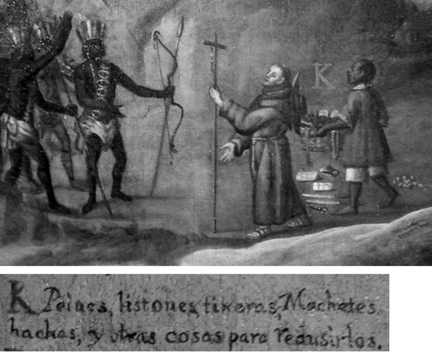
The Spaniards and other European explorers loaded their ships with objects desired by indigenous peoples—“gift kits”—which they used to establish relationships and manipulate local politics (Brain Reference Brain1975:129–130; DePratter and Smith Reference DePratter, Smith and Dobyns1980:71–74). Indigenous desires for such unfamiliar objects could be exploited as an initial instrument of social control through reciprocity: native peoples' acceptance of the goods was intended to encourage them to respond by settling peaceably under colonial surveillance, in conformance with ideas of Christian civilization and loyalty to Spain. An anonymous painting composed in the late seventeenth century (likely depicting events in Nicaragua) for the Capitanía General de Guatemala clearly illuminates this strategy, showing a priest and his assistant passing various items to indigenous people. The painting's legend identifies the objects as cosas para redusirlos or “things to reduce them” (Figure 1). In sixteenth-century Spanish, the term reducir meant “to be convinced and put in better order” (Hanks Reference Hanks2010:2), referring to the transformational process, both physical and spiritual, of bringing the idolaters to a civilized state of Christian order (Cummins Reference Cummins, Lyons and Papadopoulos2002:200–209; Gose Reference Gose2008:119).
Priest giving gifts to reduce populations (modified from Anonymous, Conquista y reducción de los indios de las montañas de Paraca y Pantasma, con Ia representación de espacios sagrados indígenas y cristianos, seventeenth century, reproduced by permission of the Museo de América, Madrid).

The physical process of this transformation was spatial and began with the policy of reducción: forcibly removing peoples from small, scattered villages and resettling them in larger communities known as reducciones de indios or congregaciones. These new settlements were centered on a hastily built church, the focus of Christianization of the “heathens” by resident or visiting missionaries. These were primarily Franciscans in the Maya lowlands. Mission settlements brought indigenous populations in closer contact with the Spaniards, deepening their interrelations and facilitating imposition of policía cristiana. Policía cristiana refers to properly ordered “small details” of everyday life, and involved the interaction of the body with social space and conduct (Hanks Reference Hanks2010:3).
Some of the Spanish gift goods were desirable and living in the “reduced” mission communities was the easiest way to obtain them. Though flight from missions was common, those who settled there by choice, such as for protection, would have had greater exposure to Spanish goods and practices. As these objects were freely appropriated into the system, they became “Trojan horses of change” (Appadurai Reference Appadurai and Appadurai1986:26), transforming indigenous systems of value and power relations but, in the process, undermining the value of the gifted objects.
In many ways, the policy of reducción and creation of congregación communities seem ripped from the pages of the work of Foucault, as they clearly incorporated strategies to structure “the possible field of action” of occupants (Foucault Reference Foucault and Wallis1984:428). Foucault's (Reference Foucault, Martin, Gutman and Hutton1988:18) four technologies of domination—power, signs and symbols, the self, and production—help explicate the mission situation.
Historically, studies of power relations and cultural contact have been disconnected, but the latter cannot be fully understood without consideration of the former (Cusick Reference Cusick and Cusick1998:131–138; Wolf Reference Wolf1982). Although power relations in colonial processes certainly involved violence, religious missionization was more effective and precise in its application of control (Chuchiak Reference Chuchiak IV2003:248). The closer contact of indigenous populations and Spaniards in reducciones, restrictions on private gatherings, and limits on spatial movement permitted easier coercion, surveillance, and control of labor, and placed occupants under the gaze of priests as well as of community leaders trying to navigate between both worlds (Hanks Reference Hanks2010:32–39; Rice Reference Rice2012). The ultimate goal of the conquista pacífica, or peaceful conquest, was to create ordered and obedient subjects (Hanks Reference Hanks2010:8). Yet, the conquista pacífica was not without physical pain. Persons who were late or did not pay attention to church services were whipped (Hanks Reference Hanks2010:64) and indigenous ritual practices were punished with torture (Tedlock Reference Tedlock1993).
Churches were not only instruments of power in Spanish colonial situations; they were highly symbolic spaces and places though which religious doctrine was communicated. Church bells, for example, were instruments of space-time control. They formed the timescape of the community, timing the ritual cycle of the church and thus the rhythm of daily lives, including the work cycle (following Birth Reference Birth2012:64–65). The church structure itself defined the center of social space and mythic history, orienting the subject toward heaven and salvation. East, the usual location of the altar and the majority of religious imagery, was the direction one faced during prayer and was the location of heaven, Jerusalem, the first sunrise at creation, and the resurrection of Christ and the dead. Facing east also signified the giving of one's soul to Christ (McCluskey Reference McCluskey, Ruggles and Urton2007:335–338).
The baptismal font, the second most important place in the church (Giffords Reference Giffords2007:213), defined the church's boundary in a physical, spiritual, and social sense. Through baptism, one replicated the actions of Christ, including martydom and resurrection as a Christian and member of the church (Giffords Reference Giffords2007:156–157; Foucault Reference Foucault, Martin, Gutman and Hutton1988:48). Baptism proclaimed the reducción and rebirth of the individual now prepared to internalize policía cristiana. The eastward movement from the font toward the altar was a metaphor for the journey of the soul from conversion toward salvation with the help of training, confession, repentance, and sometimes corporeal punishment.
Church interiors, distinct from the outside world, were adorned to stimulate the senses (particularly the visual, auditory, and olfactory) and thereby create a special experience with the expressed intent of impacting the converts' beliefs through bodily experience (Hanks Reference Hanks2010:65). Thus the church incorporated more than just technologies of symbols and power; it was also a “technology of the self,” a means through which the soul is constructed by comparing the self to a divine exemplar (Foucault Reference Foucault, Martin, Gutman and Hutton1988:16–49). The church, a key space of “reducción and conversión” (Hanks Reference Hanks2010:17), was physically oriented toward salvation. Its spatial structuring helped coordinate the habitus of daily life outside its walls as a physical representation of the Christian technology of the self/soul (Hanks Reference Hanks2010:69). Although an eastward focus of ritual space and power was of long standing among the pre-Hispanic Mayas, the partial construction of the self through Christian-defined sins, self-renunciation, and penance to refine the soul was not.
Not everyone had equal access to soul refinement. Elite males received special training, including literacy education, inside the church, while others received less intense training outside. Educated elite males were more likely to occupy political positions such as scribe and maestro cantor, the latter an important intermediary position in charge of indigenous religious education, baptism, confession, burial, prayer, hymns, and so on (Hanks Reference Hanks2010:17, 63–82). Maestro cantores also represented indigenous groups in political matters (Caso Barrera Reference Caso Barrera2002:393). Literacy allowed for textual self-reflection (Foucault Reference Foucault, Martin, Gutman and Hutton1988:27) as well as greater access to “truth” in religious texts.
Production technologies appear in various forms in the colonial world including currency, taxation, the organization of labor, wage labor, and so on. The economy of the Maya peoples in Petén missions was largely agrarian, transformed by raising livestock sold to Yucatán (Schwartz Reference Schwartz1990:41). The Spaniards had little impact on agricultural technology, but required the Mayas to produce more maize and beans, and to rely less on foods derived from the forest and gardens. They also encouraged the planting of sugarcane for sale to Ladinos, who processed it into aguardiente and sold it back to the Mayas (Schwartz Reference Schwartz1990:62).
Although the early assignments of indigenous labor through the Reconquista-inspired Spanish institutions of encomienda and repartimiento (labor drafts) had been officially prohibited, the latter continued in Petén until the late eighteenth century. Moreover, debt peonage, allowed by the monetary system, virtually enslaved many Peteneros. Besides monetary taxes, corvée labor was demanded of Maya peoples for church and government construction, the church being the major consumer (Schwartz Reference Schwartz1990:39–44). Because mission churches were largely constructed by corvée labor of community members, one might imagine that such labor requirements would evoke resentment, but the opposite is often the case. As subordinates build and renovate places and spaces, they tend to more strongly identify themselves as a community and as legitimate subjects of ruling classes (Smith Reference Smith2007:36). The placement of burials beneath the church floor made the church the space of the ancestors (Blake and Smith Reference Blake and Smith2000:371), following traditional pre-Hispanic Maya practice of burying the dead, especially rulers, below temples and other ritual structures. This practice solidified the mission church as a center of community identity that transcended time. The ancestors buried beneath the space between the baptismal font and the altar further hallowed this theater of the self-conscious and policía cristiana.
Of course, Foucault's four technologies of domination overlap. By combining technology of the self with power and symbolism, the church became a central instrument of governmentality (following Foucault Reference Foucault, Martin, Gutman and Hutton1988:19). Church bells, seemingly innocent musical instruments, were not simply key components of church architecture. Their “voices” helped create the special experience of sacred space, and also timed the secular work day. Bells were considered by some inhabitants of Petén to be part of the church's power, similar to saints (Thompson Reference Thompson1930:39). The destruction of church bells in indigenous revolts in some Spanish colonies (Liebmann Reference Liebmann2006:107–108; Saunders Reference Foucault, Martin, Gutman and Hutton1993:415) reflects their connection to colonial subjugation.
THE ITZA MAYAS AND THE SPANISH CONQUEST
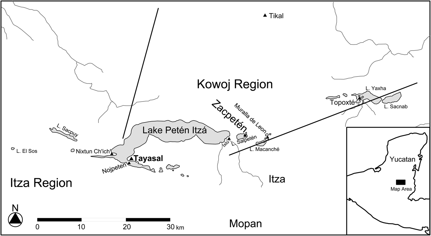
The Itzas, with their island capital of Nojpeten in southwestern Lake Petén Itzá, were the most powerful group in the Petén lakes region of Guatemala (Figure 2), and violently resisted incorporation into the Spanish empire until 1697. According to Grant Jones’ (Reference Jones1998:7–22) reconstruction of the intricately factionalized indigenous politics of seventeenth-century Petén, the principal rivals of the Itza alliance, the Kowojs, were concentrated to the northeast (Rice and Rice Reference Rice and Rice2009). Two of several factions in the Itzas' alliance were the Chakan Itzas and the Mopans. The Mopans lived to the southeast of the core Itza region and appear to have been dominated by the Itzas at conquest, yet the two groups were also frequently in conflict (Jones Reference Jones1998:19–22). The Chakan Itzas to the northwest sometimes fought with the ruling faction, often while allied with the Kowojs, but the two were sometimes at war as well. The Chakan Itzas appear to have been expanding before the conquest and were leaders of resistance afterward, along with their Kowoj allies. Chakan Itza leaders may have planted settlers in missions to facilitate resistance (Jones Reference Jones1998:403).
The seventeenth-century political geography of the Petén Lakes region, Guatemala.
The political organization of the pre-conquest Itzas was headed by a central ruler known as Ajaw Kan Ek’, along with his cousin, Ajk'in Kan Ek’, the high priest. Below were pairs of b'atab'ob, lords who ruled four provinces associated with the cardinal directions. For example, the Chakan Itza faction was ruled by two b'atab'ob before the conquest. These various elites as well as town governors served on a central council.
In March 1697, Spaniards under the command of Martín de Ursúa y Arizmendi attacked and seized the Itzas' capital of Nojpeten (Jones Reference Jones1998). This conquest and the resulting shift in power relations initiated the Colonial period (a.d. 1697–1821) in the region. Spanish-style goods—mostly produced in the Americas, usually with local variations (Deagan Reference Deagan2002:31–33)—had been trickling into Petén throughout the preceding Contact period (a.d. 1525–1697) and were greatly desired singularities (Avendaño y Loyola Reference Avendaño y Loyola, Bowditch and Rivera1987:29–30; Pugh Reference Pugh2009a:375–377). In addition, Maya immigrants fleeing the Spaniards in Yucatán, Belize, and elsewhere brought hybrid practices. Hence, at the time of the conquest of Petén, neither the Itzas nor the Spaniards can be considered impermeable or “whole” cultural entities (following Werbner Reference Werbner2001:134), and the entanglement was well on its way.
As elsewhere, the Spaniards in sparsely populated Petén practiced capital-conquest (Restall Reference Restall2003:70–71), initially leaving areas surrounding Nojpeten relatively independent, and some parts of Petén and adjacent Chiapas remained unconquered throughout the Colonial period. The Spaniards constructed a presidio (fortified administrative center) on Nojpeten, which they renamed Nuestra Señora de los Remedios y San Pablo, Laguna del Itza, now known as Flores Island, the capital of the Department of El Petén. At the beginning of the eighteenth century, the secular clergy of Yucatan began establishing a series of missions/reductions to subdue the presidio's surroundings, some of which remain as modern communities (Jones Reference Jones1998:387–397). The first, Arcángel San Miguel, was founded in 1702 on the Tayasal Peninsula across a narrow channel from the presidio.
After conquest, the Spaniards ignored the indigenous Itza hierarchy and interacted directly with the b'atab'ob. As a result, hierarchies broke down and the role of the b'atab'ob was transformed—they became brokers between the Spaniards and the Maya (Farriss Reference Farriss1984:148; Rugeley Reference Rugeley1995:478–480). In many cases, the central rulers were simply deposed, as with the two Itza leaders who were sent to the capital Santiago de Guatemala (modern Antigua), although Ajk'in Kan Ek’ was executed before arrival (Jones Reference Jones1998:383–384). Petén was not assimilated into the Spanish empire without a fight, as the Mayas resisted the Spaniards until the end of the Colonial period. The Spaniards, in turn, punished the resisters and persons who sought to flee their assigned communities with whipping and/or imprisonment (Schwartz Reference Schwartz1990:63).
SAN BERNABÉ
Sometime before 1712, Mission San Bernabé was established on the western edge of the Tayasal Peninsula, northwest of San Miguel (Jones Reference Jones1998:390). Not commonly mentioned in archives and possibly not surviving into the nineteenth century, San Bernabé's precise location was forgotten until 2010, when excavations by Proyecto Arqueológico Tayasal (hereafter PAT), directed by the senior author, discovered its traces (Pugh et al. Reference Pugh, Sánchez and Shiratori2012). More intense excavations in 2011 enhanced our knowledge of the San Bernabé church and the surrounding congregación community and encountered evidence of material hybridity. Although damaged by modern activity, San Bernabé is perhaps the best preserved early mission site in the Petén lakes region and the only one investigated intensively.
A 1712 census identified 126 occupants of San Bernabé. By 1766, the population had plunged to 37 adults, although children seem uncounted. The decrease was likely the result of epidemics, but flight was also a contributor. A letter written by an indigenous maestro cantor in 1745 (transcribed in Caso Barrera Reference Caso Barrera2002:393), petitioning for a wage increase, mentions the b'atab'ob of San José, San Andrés, San Jerónimo, and San Bernabé in that order, and refers to the regional Spanish governor as the halach winik. In so doing, the document introduced the four reduction towns in the western end of Lake Petén Itzá by tracing their locations counterclockwise. This is a sequence typical of indigenous ritual discourse and represented ordered space and social organization (Coe Reference Coe1965; Edmonson Reference Edmonson1986:81). As such, this referencing established the credibility of the letter in an indigenous manner. Moreover, the fact that the letter constituted collective bargaining on the part of the four b'atab'ob hints at some sort of indigenous socio-political organization on the western side of the lake, which may correspond with a Chakan Itza sphere of control. Nearby San Miguel, which was clearly under Spanish domination, was not part of this association. Although the Spanish governor is mentioned as the halach winik, the Itzas—most likely the Chakan Itzas—had seated an indigenous halach winik in 1699 at a place called Chun Ajaw near Lake Sacpuy to the west after the Spaniards moved Ajaw Kan Ek’ to Santiago de Guatemala (Jones Reference Jones1998:383–384). It is unknown how long the local regional leadership persisted.
Another archival mention of San Bernabé comes from the 1750s: a resident named Kowoj attempted to instigate a region-wide rebellion during holy week, when large numbers of Mayas would visit the presidio (Jones Reference Jones1998:410–418). In addition, a b'atab’ of San Bernabé, Juan Kunil, has what appears to be a Mopan surname and the Mopans apparently held high status in the San Bernabé parish (Caso Barrera Reference Caso Barrera2002:393; Jones Reference Jones1998:25). Thus the parish incorporated other groups besides the Chakan Itza/Kowoj alliance. The spatial hierarchy between the mission church at San Bernabé and the Iglesia de Nuestra Señora de los Remedios y San Pablo of the island presidio established and reflected both the social hierarchy between communities as well as that between the Mayas and Spaniards. Our recent research supplements the sparse historical data, providing a more revealing glimpse into life at San Bernabé and Maya cultural entanglements with the Spaniards.
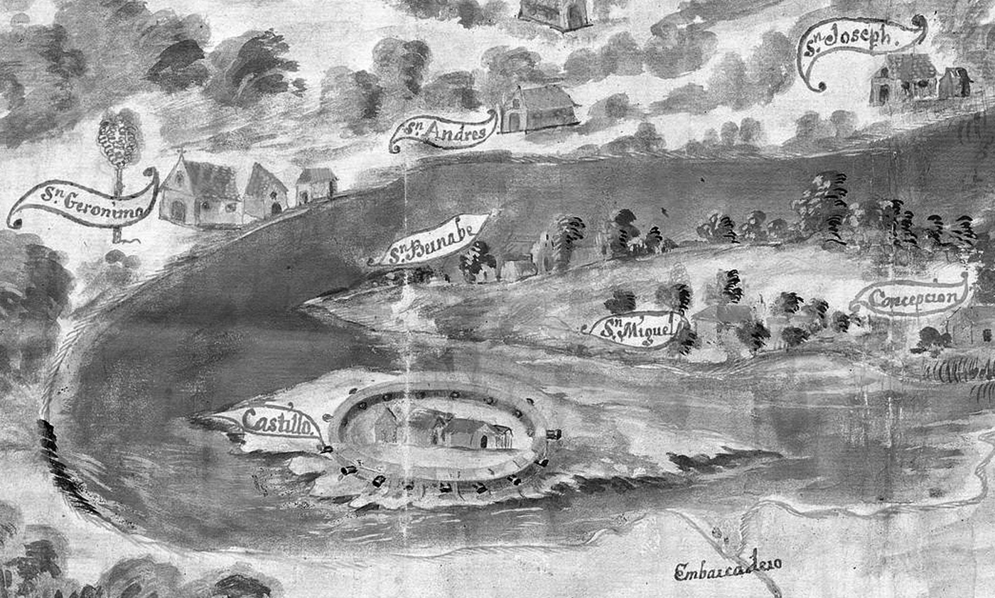
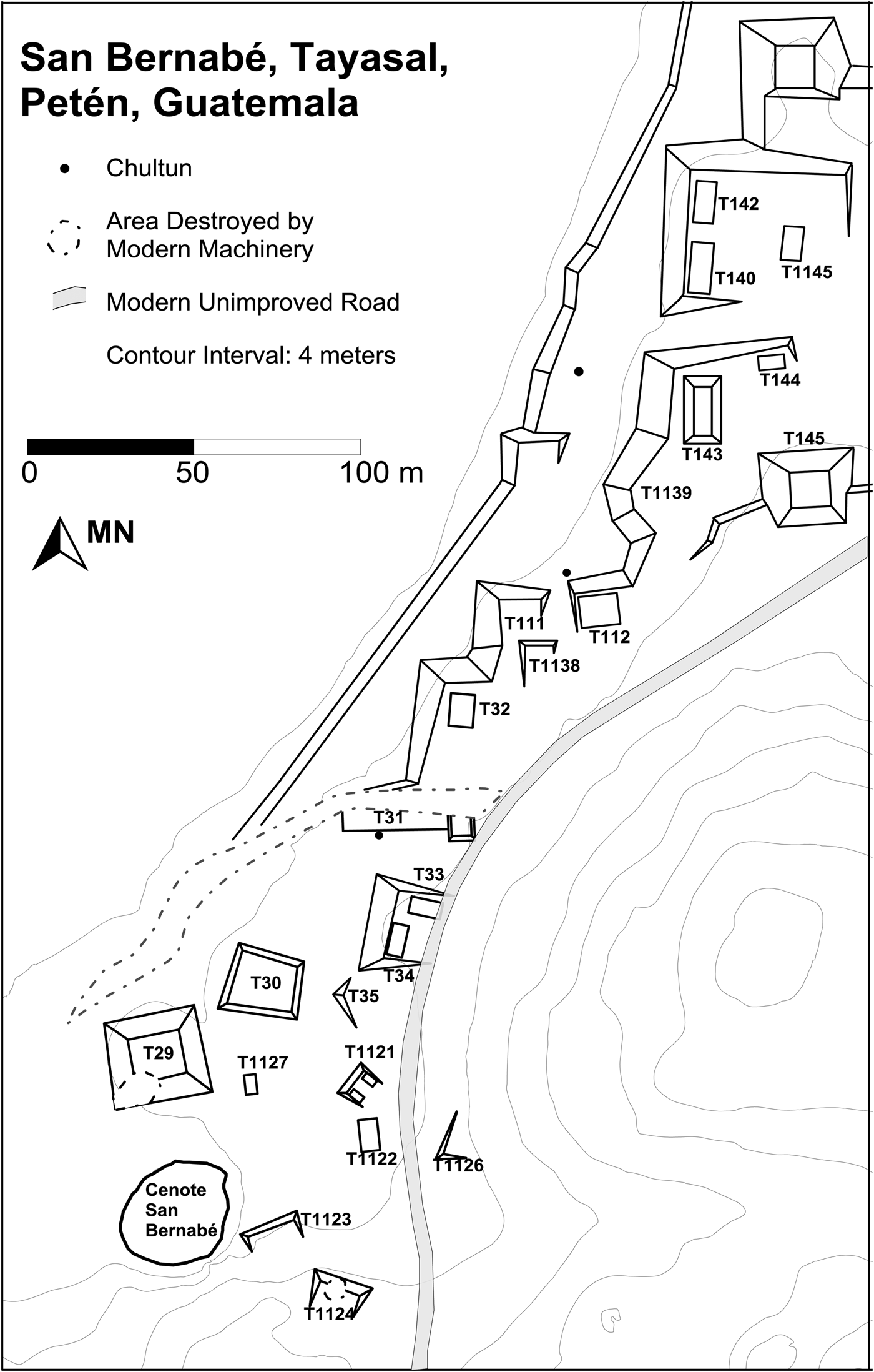
A perspective map painted in 1740 (Figure 3) illustrates the several missions and other settlements in the Petén lakes region, depicting San Bernabé's church and surrounding buildings in the northwest portion of the peninsula. Mounds almost certainly representing the central ruins of Classic-period Tayasal occupy the hills to the east of the town. In 1971, excavations conducted by the University of Pennsylvania (Penn) encountered Colonial-period ceramics and metal artifacts on the western tip of the peninsula (Chase Reference Chase1983:730–795), but it was not recognized that these artifacts once belonged to the occupants of the San Bernabé mission. In 2010, PAT searched for the mission as part of the goal of understanding the colonial process in Petén (Pugh et al. Reference Pugh, Sánchez and Shiratori2012). Our search began in the area corresponding to where San Bernabé was marked on the 1740 painted map and where Penn had encountered Spanish-style objects. We found the church in our first excavation block, placed on a platform known as Structure T31 (Figures 4 and 5). Thus, although the painted map inaccurately illustrates the Tayasal Peninsula as an island, it correctly locates the mission on it and the nearby topography: San Bernabé lies at the base of karst hills to the east and south on a gentle slope leading to the northwestern shoreline.
Colonial-period settlements in Petén in 1740 (Adapted from Anonymous, Mapa de la provincia del Petén y del castillo de su nombre, 1740, Mapas y Planos, Guatemala 26, reproduced by permission of Archivo General de Indias, Ministerio de Educación, Cultura y Deporte, Spain).
The archaeological remains of San Bernabé, Tayasal, Guatemala.
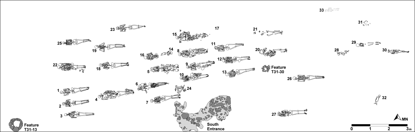
Burials and features, Structure T31, Tayasal, Guatemala.
In the southern part of San Bernabé a now-dry cenote once held water when lake levels were high. A test unit in the cenote revealed that uppermost layers of sediments included little clay whereas Level 6, the first level with a substantial amount of clayey material, also included the nearly complete skeleton of a pond slider, a medium-sized aquatic turtle (Trachemys scripta). The large amounts of clay indicate that low-energy pooled water trapped sediments that had been variously transported by erosion, formed inside the cenote from organic material, or weathered from submerged limestone. A radiocarbon assay of the turtle carapace (AA97500) produced an age of 401 ± 35 years, yielding 2σ-range dates of cal. a.d. 1434–1524 (75.2% probability), 1558–1564 (0.9%) and 1570–1631 (23.9%). Thus the cenote last contained substantial amounts of standing water in the Late Postclassic (a.d. 1400–1525) and/or Contact periods. All strata below Level 6 also had high clay content but without intermittent lenses of other soils, indicating a fairly constant presence of pooled water. Excavations struck the water table 2.8 m below ground surface, which corresponds to the current lake level. Thus, the water in the cenote parallels the fluctuating levels of Lake Petén Itzá.
The San Bernabé mission site extended at least 275 m northeast from the cenote. Excavations were not possible along the shoreline as it is private property, but we assume that the community extends from the base of the hills to the shoreline approximately 230 m to the northwest. The topsoil in most places at San Bernabé is uncharacteristically thick for Tayasal and includes two A horizons. The lower horizon, which contains colonial artifacts, appears to have been recently buried by the upper, which includes sparse modern artifacts and little else. This recent A horizon likely accumulated as a result of cattle ranching and associated erosion from the nearby hills during the twentieth century. Limestone bedrock is generally encountered within a meter of the surface in unmodified areas. Excavations revealed occasional perched water tables above the bedrock that could have been water sources.
The San Bernabé mission was congregated over a substantial Late Preclassic period (400/300 b.c.–a.d. 200) occupation (Chan Nieto et al. Reference Chan Nieto, López, Avila, Pugh, Sánchez, Arroyo, Paiz and Mejía2012) that had been reused in the Terminal Classic period (a.d. 800–930). These earlier constructions provided platforms and building materials for Colonial-period structures. In fact, Tayasal experienced its most intensive construction during the Late Preclassic period. A massive 300 m-long (north/south) and 270 m-wide (east/west) T-shaped platform was built in the site center; in some areas the fill is more than 7 m deep. In the lowest fill levels Chicanel material was mixed with earlier Mamom sherds, indicating that the site included Middle Preclassic construction (800–400/300 b.c.). Late Preclassic developments in the vicinity of San Bernabé included a large triadic temple (Structures T65–T67) and surrounding residences.
In the San Bernabé area proper, excavations encountered a circular platform (Structure T30a), likely dating to the Late Preclassic period, and associated residences (Pugh et al. Reference Pugh, Sánchez and Shiratori2012:14). Numerous quarries in the bedrock indicate that the Preclassic community in this area focused on mining and dressing limestone blocks. Following the Late Preclassic, the area experienced an occupation hiatus until the Late (a.d. 600–800) and Terminal Classic (a.d. 800–950) periods, when several residential structures were built. Although a large Late Postclassic community lies immediately to the south and a substantial Late Postclassic-through-Contact period settlement existed in Group 23, 300 m to the east, the San Bernabé area itself was only sparsely occupied. The mission represented the next and final pre-modern occupation of the area.
From a historical perspective, the Contact and Colonial periods are clearly separated in Petén, as no substantial interactions occurred among Spaniards and Itzas between the visit of Hernán Cortés in 1525 and the last decade of the seventeenth century. However, indigenous populations continued to use local ceramics and stone tools well into Colonial times, so it is often difficult to isolate the periods archaeologically if Spanish-style goods such as iron objects, glass beads, or tin-enameled earthenwares are absent. Nevertheless, we are beginning to be able to differentiate these periods with indigenous diagnostics, one of which is the Ixkamik Unslipped pottery type.
THE SAN BERNABÉ CHURCH
The painted map of 1740 depicts several buildings in San Bernabé, including two with elaborate façades, both facing east (Figure 3). One includes three niches that might represent a three-bell campanario and is most likely the church. The physical remains of the San Bernabé church were identified in excavations into Structure T31, a low mound damaged by a bulldozer in the 1960s or 1970s. The bulldozing destroyed the northern portion of the platform—and likely half of the church, which was constructed primarily of perishable materials. The extant portion of the church is approximately 22 m long and 5 m wide, and oriented 78.5° east of north. Subfloor burials (see below) largely defined the church's horizontal limits (Figure 5). A chultun adjacent to the church's south wall was likely covered during the Colonial period, as excavations carried out by Penn recovered Late Classic-period artifacts, plus bones of a modern horse (Chase Reference Chase1983:758), and diagnostic Colonial artifacts were absent. All available evidence suggests that the San Bernabé church was typical of the small, open mission churches found throughout poor, rural parishes in the Maya area (Graham Reference Graham2011:167–188; Perry and Perry Reference Perry and Perry1988; Putz et al. Reference Putz, Heck and Förster2009).
Excavations revealed patches of a preserved floor throughout the western half of the church, but the floor was not preserved in the east. In the area of Burials 18, 19, 22, and 25, to the west, the construction history was more complex, with traces of three or possibly four floors, each separated by thin soil ballast. The floors were not hard lime plaster as is typical of Maya buildings of earlier periods, but a mix of soil, ash, and pulverized limestone. The burials penetrated the lower two floors and possibly all of them. It is unknown why these floors existed in only a limited area, although their absence in the east was at least partially the result of bulldozing. In addition, the church structure likely changed during its use-life and the area with more complex stratigraphy may have been used over a longer period of time. The burials in the area of the multiple floors generally included multiple individuals, while those outside this area tended to include only one, supporting the idea that the several floors represent repeated mortuary sealings in the oldest portion of the church (Pugh and Sánchez Polo Reference Pugh and Polo2012).
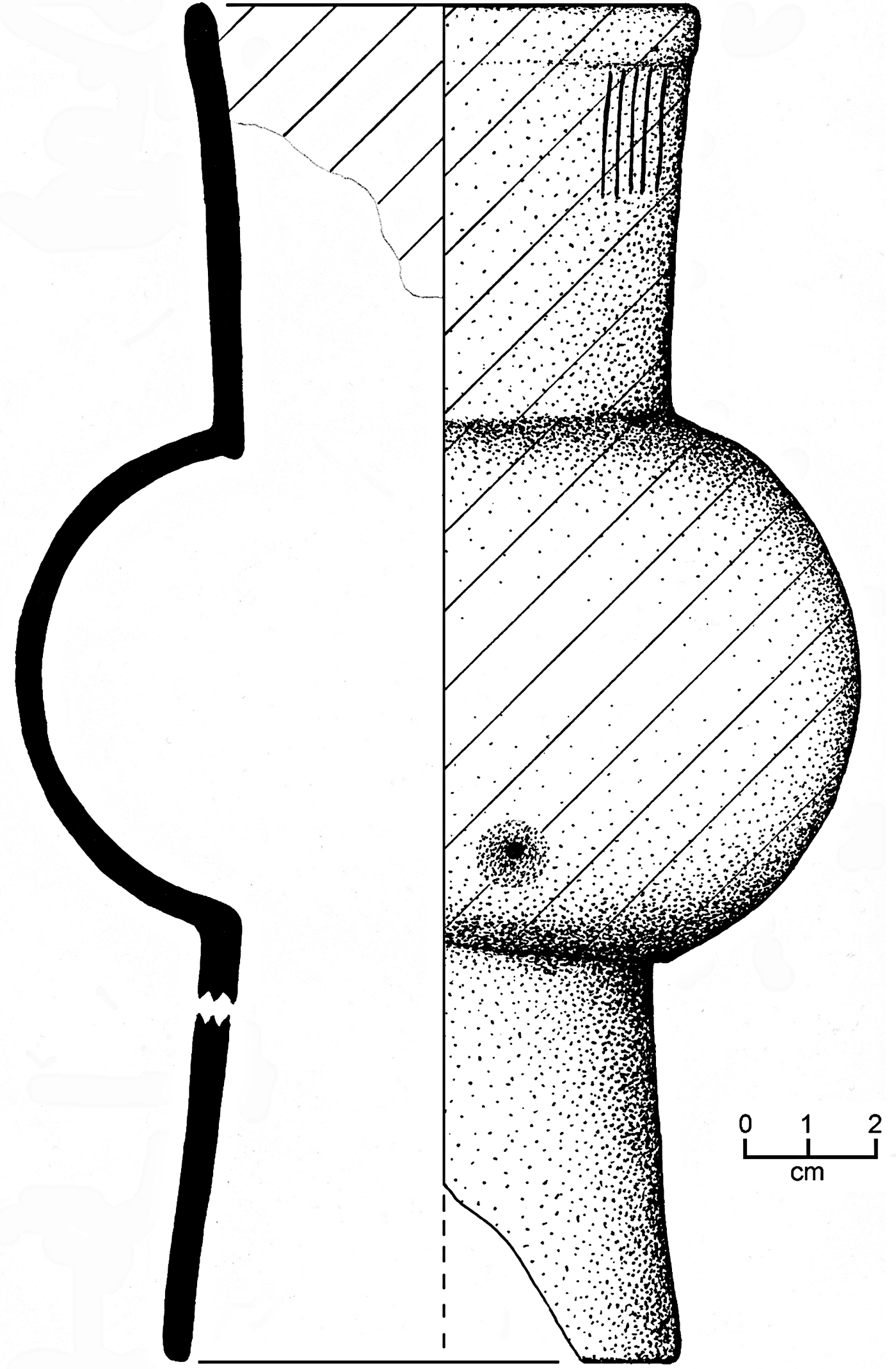
In the southeast corner of the church stood a circle of mortared stones (Feature T31-13) that once secured a wooden post with a diameter of 32 cm. Large fragments of the post and a piece of unidentified iron rested deep in the postmold, although a perched water table prevented investigating deeper than 78 cm. North of the masonry circle, a cache included a nearly complete Picú Incised: Thub Variety pottery drum (Figure 6), Paxcamán Red sherds, fish bones, net sinkers, freshwater snail shells, a small obsidian projectile point, and other artifacts. Apart from the drum, the deposit could be mistaken for a trash pit. Nevertheless, similar deposits were noted above or adjacent to burials, caches, other special features in San Bernabé and Late Postclassic-period Tayasal, indicating that the cache likely dedicated Feature T31-13.
Picú Incised: Thub Variety pottery drum, Structure T31, Tayasal, Petén, Guatemala.
We previously interpreted the large masonry feature as a column (Pugh et al. Reference Pugh, Sánchez and Shiratori2012:13). However, its position, absence of other large columns, and lack of substantial masonry walls suggests that it could instead have been a baptismal font. This use is also suggested by the fish and high frequency of net sinkers in its dedicatory cache. Fonts, baptism, and Christianity were associated with fish, and the church was considered a boat (Giffords Reference Giffords2007:333–334). This symbolism may have also paralleled the priest administering the baptism with St. Peter and St. Andrew, who fished with nets and became “fishers of men.”
A second feature (Feature T31-30) lay 13 m northeast of the column/font. This feature was composed of burned limestones lacking mortar, forming a circle 15 cm in diameter; no wood fragments, evidence of a post-shaped feature, or special deposits were found in the circle. It is probable that Feature T31-30 marks the location of an actual column, the base likely supported by the ring of stones. Like the column/font, this feature was ritually dedicated. An adjacent deposit of Paxcamán Red plate fragments and tripod supports lay on the north side. Paxcamán tripod plates were uncommon in this portion of San Bernabé and those that did occur tended to be located atop caches.
South of the burials in Structure T31 is a mass of stones and mortar with a well-defined line on its south side. We initially interpreted this mass as foundation stones (Pugh et al. Reference Pugh, Sánchez and Shiratori2012:13), although this interpretation now seems unlikely as it appears the mass lies outside the building. We now believe that the stones mark a side entry into the church. Although modern churches in Central America often have primary accesses opposite the altar (usually at the west), many mission churches such as Tipu and Lamanai (the earlier church, YDL I) in Belize were entered perpendicular to the nave and altar. In the case of these two churches, the altar was to the east and entrances to the north and south (Graham Reference Graham2011:Figures 8.17 and 8.23). Lamanai YDL I included a stair at each entrance and the Tipu church had cobble-paved paths at each doorway. Thus it seems likely that the mortared stone mass outside Structure T31 was a low stair or a paved path marking the southern entrance to the church.
We assume that the chancel and altar were to the east of the burials, as this is a typical pattern in Catholic churches (Graham Reference Graham2011:175). These features are frequently located in the direction of the interred individuals' feet (or the directions that the burials faced) in churches in the Spanish colonies (Saunders Reference Saunders and McEwan1993:56). Unfortunately the 2010–2011 excavations encountered neither chancel nor altar structures and the bulldozing likely destroyed them: damage on the east side of the church was much more profound than to the west.
BURIALS
Excavations in 2010 and 2011 encountered 32 burials in the extant portion of the church structure and one deep beneath the church. The latter (Burial 32) dated to the Late Preclassic period and will not be considered further here. Many of the church burials included the remains of multiple individuals. In all such cases, the person buried last was articulated and earlier interments were partially or completely disarticulated. The locations of the burial pits appear to have been well-recorded as they were reopened precisely above the remains, which were disinterred and then carefully replaced in the graves. For example, the skull of an earlier occupant of Burial 22 was placed adjacent to the skull of the latest occupant and two skulls rested above the feet of Burial 5. Burial 20 was initially occupied by a young adult female and three infants were added later—at different times—in the area of her chest and pelvis. Thus, the disarticulated remains of earlier individuals were not haphazardly replaced in the graves, but carefully and sometimes creatively reinterred with later persons. Similar practice is evident at Lamanai and indicates that the burials were marked (Graham Reference Graham2011:208). One assumes that individuals buried in the same sepulture were related, although the rules regarding ownership of particular burial spaces varied (Jacobi Reference Jacobi2000:34). Reinterred remains were not always easy to interpret: Burial 15 includes one articulated individual and partial remains of at least five other completely disarticulated partial individuals.
All but two burials in Structure T31 followed a “High and Later Medieval” European (hereafter HLME) burial pattern (sensu Müller-Wille Reference Müller-Wille1993:10). Undisturbed individuals rested in a supine, extended position with feet to the east and heads pedestaled to face the east. In addition, most of the crania returned to graves after disinterment were oriented to face east. Given the association of the east with heaven and resurrection, this orientation is not surprising. As in other cemeteries in Spain's colonies, the hands appear to have been placed together and positioned “variously from immediately below the chin to the mid-abdominal line” (Larsen Reference Larsen and McEwan1993:325), although they were sometimes clasped, “praying,” or with one hand grasping a wrist (Graham et al. Reference Graham, Pendergast and Jones1989:1258; Warinner et al. Reference Warinner, García, Spores and Tuross2012:472–473). We found no coffin nails or shroud pins, though we assume that the remains were shrouded as found at other colonial cemeteries (Warinner et al. Reference Warinner, García, Spores and Tuross2012:473). Burial 27 was the only grave with a clear “monument,” another characteristic of the HLME pattern. This shallow interment, covered by a concentration of stones with traces of mortar, likely lay outside the church and the covering protected the remains from scavenging animals.
Two interments in the San Bernabé church deviated from the HLME template. Burial 14, an infant, was interred in a supine, extended position, with the hands at the waist but the feet to the west. The infant had been buried in the same sepulture as Burial 16, a young adult whose legs and feet were removed and placed on the abdomen to allow for the placement of Burial 14. The infant may have been oriented to face the adult or the placement may indicate that the child had not been baptized.
The second anomalous burial, Burial 24, was an Itza-style interment of an adult in a cist extending about 50 cm deeper than the other graves in Structure T31. The individual was seated and flexed with the head facing east before it collapsed into the lap upon decomposition. This burial was initially identified by a concentration of sherds above and slightly to the east of the cist. Pottery included Paxcamán, Pozo Unslipped, and Ixkamik Unslipped types, which, like those of the columns, marked and perhaps dedicated the burial. Although Burial 24 does not physically overlap another interment, its positioning between Burials 7 and 10 seems anomalous as it does not have the spacing consistent with that of other interments. Because it is unlikely that a priest actually lived at San Bernabé, some religious freedom may have existed, but the clear HLME patterning seen in the other burials suggests otherwise. Burial 24 seems literally out of place, and this interment might predate construction of the mission church or was placed very early in the life of the mission, as cist burials were encountered in recent public-works excavations on Flores Island/Nojpeten. Alternatively, as in other missions (Graham et al. Reference Graham, Pendergast and Jones1989:1258), Burial 24 may represent a variation in usual practice for this individual, perhaps as a form of resistance or an attempt to interweave pre-Columbian and Catholic practices.
With the exception of Burials 14 and 24, the bodies interred in the church exemplified policía cristiana. The remains were positioned to incorporate church doctrine and reflect membership in the congregation. When disturbed to allow the placement of another Christian interment, the skulls were replaced to face to the east—again, salvation. Because the deceased persons were incapable of intentional action, the mortuary rites externalized the policía cristiana of the participants.
PRELIMINARY OSTEOLOGICAL ANALYSIS
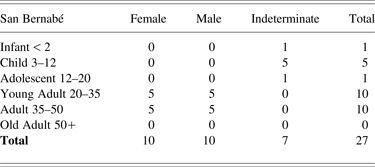
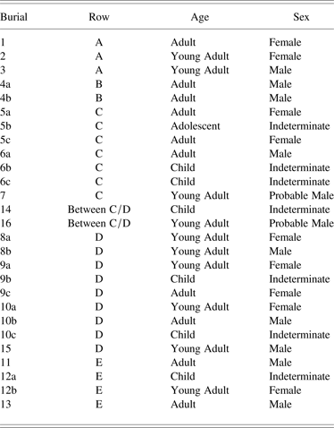
Seventeen of the 33 burials were analyzed in 2011 and contained a total of 27 complete individuals (Miller Reference Miller, Pugh and Polo2012). Nine graves contained more than one individual; grave 15 included partial commingled remains of more five individuals (which are excluded from the complete individual count). We can begin to paint a preliminary picture of the burial population and have identified 20 adults (10 women, 10 men), one adolescent, and six children interred in the 17 graves (Table 1).
Sex and age at San Bernabé, Petén, Guatemala
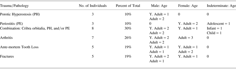
Fourteen individuals demonstrate signs of non-specific stress markers (NSMs), indicative of bodily stress and expressed as cribra orbitalia, porotic hyperostosis, and periostitis in the long bones, most notably in the tibiae (Table 2) (see Buikstra and Ubelaker Reference Buikstra and Ubelaker1994; Wright and Yoder Reference Wright and Yoder2003). Similar patterns of stress markers have been noted in other Colonial-period populations (Cohen et al. Reference Cohen, O'Connor, Danforth, Jacobi, Armstrong, Larsen and Milner1994; Tiesler and Zabala Reference Tiesler, Zabala, Tiesler, Zabala and Cucina2010; Warinner Reference Warinner2010). These stresses can be caused by numerous factors including anemia, parasitic infections, thalassemia, malnutrition, environmental stressors, cultural practices, or host resistance. The most severe systemic infection was noted in individual 5A, with evidence of bony expansion owing to systemic infection, scurvy (vitamin C deficiency), or treponematosis (yaws). Unfortunately, the specific etiology is difficult to pinpoint in this case. Although there is evidence of stress in this population, the so-called Osteological Paradox (Wood et al. Reference Wood, Milner, Harpending, Weiss, Cohen, Eisenberg, Hutchinson, Jankauskas, Česnys, Katzenberg, Lukacs, McGrath, Roth, Ubelaker and Wilkinson1992; Wright and Yoder Reference Wright and Yoder2003) highlights that skeletal lesions in the sample do not necessarily indicate that the living population was similarly afflicted. Additionally, a skeleton free of lesions does not necessarily indicate a “healthy” individual. Those with strong immune systems would survive an illness long enough for it to mark the skeleton, whereas those with weak immune systems could succumb to disease quickly, thereby leaving no skeletal markers.
Non-specific stress markers at San Bernabé, Petén, Guatemala
Traumatic lesions were noted across the sample. The most severe fractures were observed in the spinal column and long bones of five individuals, suggesting occupations or lifestyles that put excessive strain on the back. Several individuals displayed “rowing facets” on the clavicles, which underscores the known heavy use of canoe transport on the lake, as the repetitive motion of paddling leaves telltale marks in the upper body (Lai and Lovell Reference Lai and Lovell1992; Molnar Reference Molnar2006). In addition, fractures were often observed in the hands, especially in the fourth and fifth metacarpals. These fractures may result from the hand being caught between the side of the canoe and the paddle during front-to-back strokes. San Bernabé was located on the shoreline of Lake Petén Itzá and extensive dugout canoe use is well documented in the area from 1525 until recently (Jones Reference Jones1998:34). Thus injuries from canoe transport are not surprising.
Intracemetery Patterns
The San Bernabé burial patterns reflect both Christian and Maya traditions and, because this was a Colonial-period cemetery, we were interested in who was buried there. To investigate relationships, ongoing studies are collecting basic osteological, paleopathological, biodistance, dental metric, and morphological data in concert with cranial and post-cranial non-metric data following standard methodology (Buikstra and Ubelaker Reference Buikstra and Ubelaker1994; Hillson et al. Reference Hillson, FitzGerald and Flinn2005; Stojanowski Reference Stojanowski2007). Dental metric data in particular can provide a powerful means for analysis of intra-cemetery structure (e.g., Stojanowski and Schillaci Reference Stojanowski and Schillaci2006) but the present sample is too small to provide statistically significant results.
Consequently, cranial, postcranial, and dental morphological data were analyzed for patterns across the cemetery, primarily by considering individuals buried in rows (identified by letter in Table 3). The most notable grouping occurs in seventeen ASUDAS dental morphological traits (Turner et al. Reference Turner II, Nichol, Scott, Kelly and Larsen1991) and skeletal morphological traits (Buikstra and Ubelaker Reference Buikstra and Ubelaker1994) across the cemetery. In Rows C and D, some individuals in Burials 5–10, 14, and 16 are likely closely related. For example, individuals in Burials 5, 6, and 7 in Row C, aligned north-south, share ten traits (e.g., marked shoveling, double shoveling, accessory dental cusps, condylar canals, wormian bones). When Burials 14 and 16 are considered as part of this central grouping, a pattern emerges that links Burial 5 with Burials 16 and 8 in a southwest-northeast row. Among the three individuals in Burial 5, 5a and 5c share more traits than pairs 5a and 5b, or 5b and 5c.
Burial number, row designation, age group, and sex at San Bernabé, Petén, Guatemala
Interestingly, Burial 3, on the western margin of the cemetery, shares dental and skeletal traits with individuals in the center groups in Rows C and D, where the complexity and density of burials is greater than in the western rows. This could suggest that those in the center were interred later than those on the margins, who might be more distant relatives of those in the center. Alternatively, if interments were relatively coeval, then those at the margins could be members of the same familial group with different economic resources or association with the church that affected the locations of their graves (see Giffords Reference Giffords2007:70; Jacobi Reference Jacobi2000:172–176).
On the one hand, children appear to be underrepresented in the San Bernabé church, as is frequently the case in colonial cemeteries (Hoshower and Milanich Reference Hoshower, Milanich and McEwan1993:223). On the other, early post-conquest census figures suggest “a significant decline in the number of children” in central Petén, probably due to disease (Jones Reference Jones1998:406, 408). At San Bernabé they tended to be buried in the east: Burials 28, 29, and 30 include children or adolescents; Burial 20 includes three infants; Burial 14, one infant; and Burial 6, an approximately 5-year-old child. No children were in the two westernmost rows. This pattern contrasts with that in the church at Tipu, where juveniles were more frequent in the back/west (Jacobi Reference Jacobi2000:106). The damage to the eastern side of San Bernabé church by bulldozing also may have reduced the frequency of child burials.
Members of the San Bernabé community were buried in the church according to Late Medieval Catholic practices, making this the predominant pattern and accentuating the role of the church as the parish's central place. Position in the cemetery may reflect the status of the person while alive but, unfortunately, the sample of Postclassic- and Contact-period burials is currently too small to provide a representative pre-conquest population for comparison. The human remains reveal that the occupants of the mission experienced physiological stress and led lives in which they engaged in hard physical labor during a markedly complex cultural and social period in the history of Lake Petén Itzá.
SAN BERNABÉ RESIDENTIAL AREA
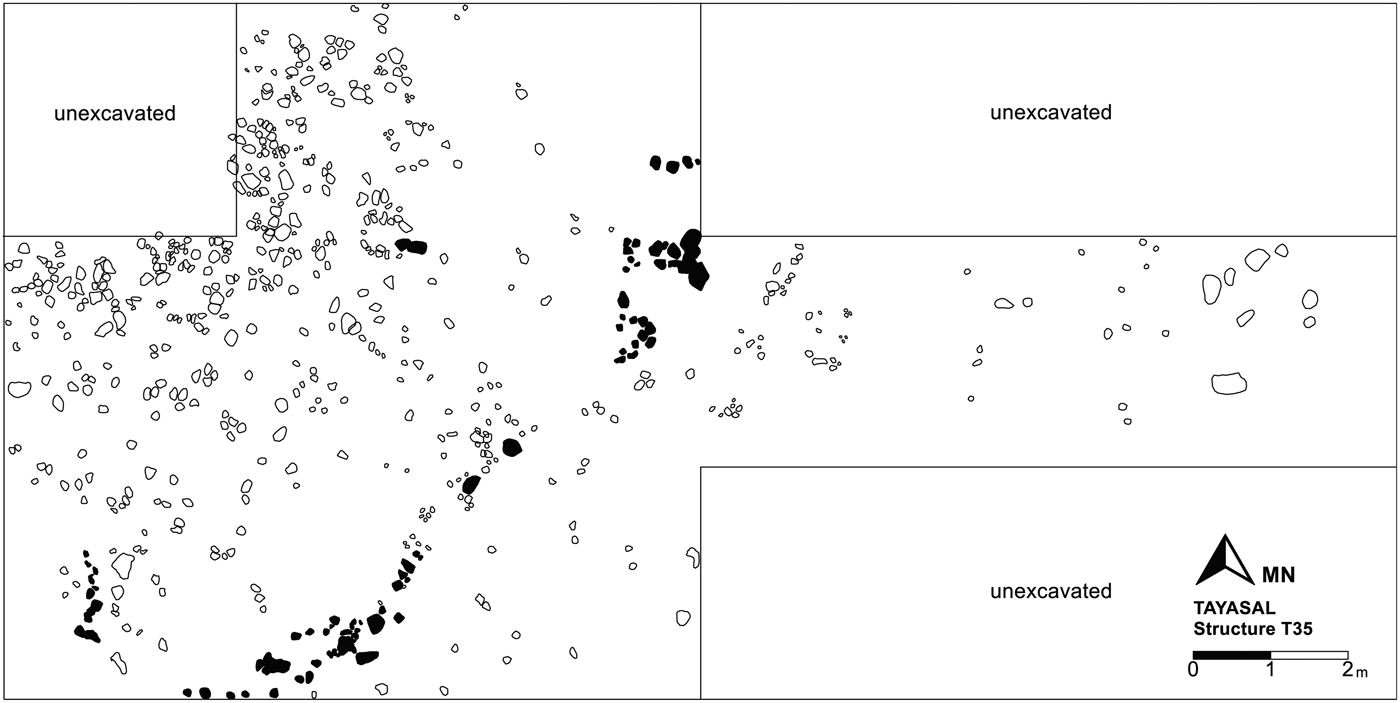
The church centered the San Bernabé parish socially, politically, religiously, and possibly economically, but Colonial-period residences also lay to the north and south. Project work in 2010–2011 focused on the area south of the church, although some excavations investigated the northern area. Three excavated buildings were occupied during Colonial times: Structures T29, T30, and T35 (Figure 4).
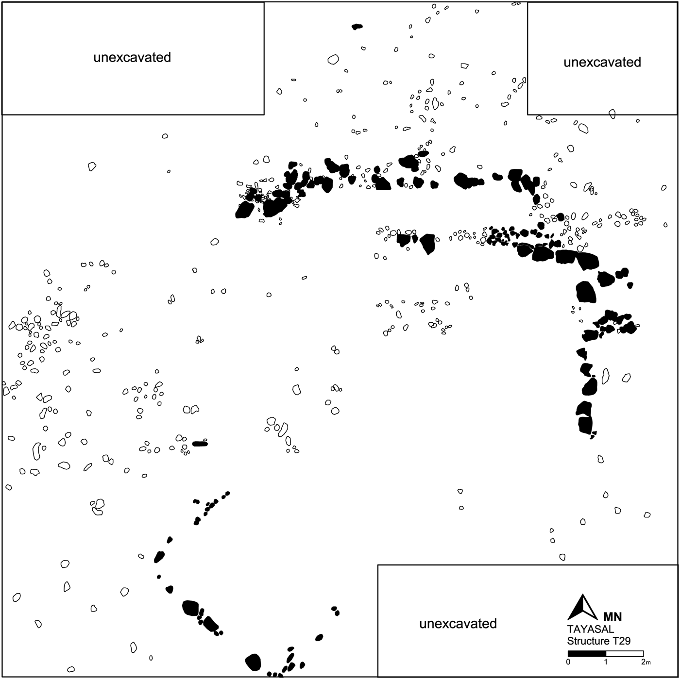
Structure T29 (Figure 7) is a 2.5 m-high platform 16 m north of the cenote, oriented 0° 30’ east of north. A large gouge on its south side resulted from modern use as a source of construction fill. The platform was originally occupied during the Late Preclassic period and reused in the Terminal Classic. During the Colonial period, a small rectangular superstructure (Structure T29a) was constructed atop the platform and faced 46° 30’ east of north, directly toward the church (Structure T31). Structure T29a is atypical of those in Late Postclassic Petén. Measuring 3 by 4.8 m, it consists of a foundation formed by a single course of medium-sized limestone rubble embedded into the platform, defining the outline of a building of perishable material. The structure was open on the north side, but this might be a result of modern disturbance.
Structure T29, Tayasal, Guatemala.
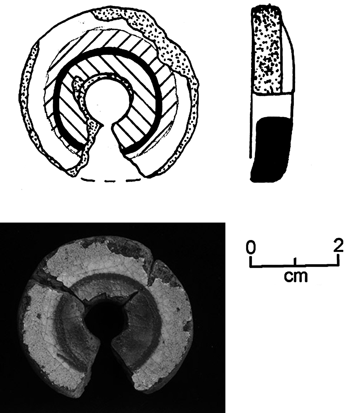
Most of the artifacts in Structure T29 were found in refuse deposits on the northern and eastern platform edges. These included a relatively high frequency of tin-enameled wares (below), one sherd of which had been reworked into a spindle whorl (Figure 8). Excavations also encountered various pieces of miscellaneous iron, glass beads, an iron lock, a silver real cob (coin), and a glass lens chipped into a circular shape, likely part of eyeglasses. Although Structure T29a was not a large building, Structure T29 was the highest platform in the area and these associated artifacts suggest that its occupants were of relatively high status at San Bernabé.
Leonor Polychrome spindle whorl, Structure T29, Tayasal, Guatemala.
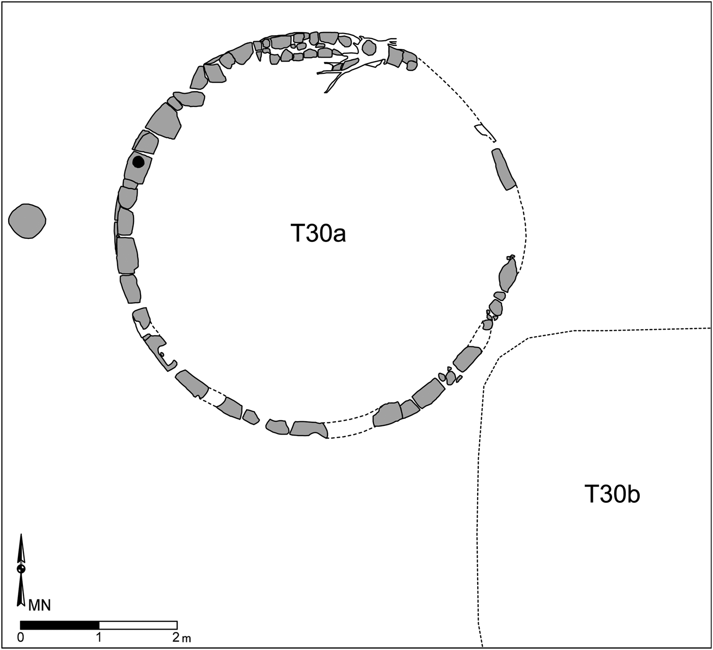
Structure T30 (Figure 9), northeast of Structure T29, is a platform supporting a circular superstructure (T30a) likely built in the Late Preclassic period and heavily used in the Late to Terminal Classic (Pugh et al. Reference Pugh, Sánchez and Shiratori2012:14–15). East of this circular structure, a small, low, Colonial-period construction appears to have been the bench of a domestic building (Structure T30b), although we did not recover evidence of other architectural features. On the northern side of the bench a roughly circular concentration of sherds of indigenous Postclassic pottery types, including Ixpop Polychrome and several Paxcamán Red tripod feet, overlay a piece of coral—part of a cache that likely dedicated the residence. South of the bench a concentration of animal bones, including fragments of turtle carapace, represented household refuse. Various colonial artifacts were recovered on the platform surrounding Structure T30b, including kaolin pipe stem fragments, sparse tin-enamel ware sherds, and a copper-alloy finger ring.
Structure 30, San Bernabé, Petén, Guatemala.
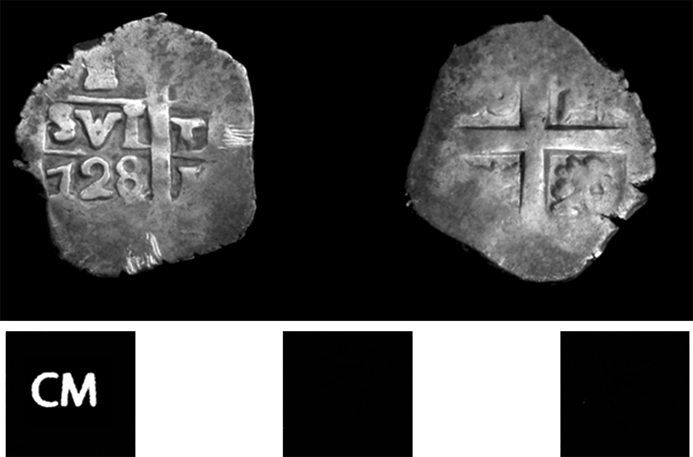
The third possible Colonial-period residence, Structure T35 (Figure 10), is a low platform on a bedrock outcrop east of Structure T30, and melds into the eastward-sloping terrain. Excavations revealed a line of stones oriented 43° east of north, likely the edge of the residence, although we could not clearly define other architectural features. A relatively high concentration of artifacts, including tin-enameled ware and Ixkamik Unslipped sherds, animal bone, and another silver one-real cob (Figure 11), was in a refuse deposit east of this wall.
Structure T35, Tayasal, Guatemala.
Real cob, Structure T35, Tayasal, Guatemala.
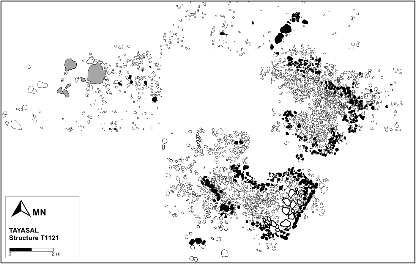
Structure T1121 (Figure 12), 10 m south of Structure T35, is an anomalous building with a C-shaped bench penetrated by a medial niche or doorway. We have not discerned another building with this shape in the San Bernabé community, although it is typical of Late Postclassic sites in the lakes region. In particular, Structure T1121 resembles structures in Group 23 at Tayasal, some of which may be residences. The structure form corresponds with oratorios at Mayapan, which also occur at the Kowoj sites of Zacpetén and Topoxté in Petén (Proskouriakoff Reference Proskouriakoff, Pollock, Roys, Proskouriakoff and Smith1962:90–91; Pugh Reference Pugh2003:410; Pugh and Rice Reference Pugh, Rice, Rice and Rice2009:166–172; Smith Reference Smith, Pollock, Roys, Proskouriakoff and Smith1962:220–221). Structure T1121's orientation, west/northwest at an azimuth of 60° west of true north, may support its interpretation as an oratorio. At Zacpetén, residences did not face west: only temples and oratorios were oriented in that direction (Pugh Reference Pugh, Rice and Rice2009b:177). Similarly, a colonial relación states that houses in Yucatán did not face west for the same reason (Tozzer Reference Tozzer1941:86). Several fragments of shaped stone, likely a broken, uncarved monument, lay a few meters west of Structure T1121, which adds to its ceremonial air.
Structure T1121, Tayasal, Guatemala.
Structure T1121 yielded no discernible de facto refuse and little primary refuse, so artifact distributions do not aid in determining how the building was used. We encountered sparse composite censer sherds, but not enough to suggest that they played a role in the building's functions. The high frequency of sherds of the Paxcamán ceramic group and few Ixkamik Unslipped fragments suggests that Structure 1121 likely predated establishment of the mission, but we have found no other evidence of a pre-conquest/pre-reducción community in the area. Establishment of the mission settlement was likely accompanied by destruction and abandonment of “pagan” religious structures and objects, such as oratorios and their incense-burners.
A fifth excavated building, Structure T1122, south of Structure T1121, seems to have been occupied during the Terminal Classic period; it exhibits little evidence of Postclassic- or Colonial-period use.
Most colonial residences at San Bernabé were small buildings with perishable superstructures. Some retained bench features typical of Postclassic-period residences. House forms appear to have varied, which one might expect in a community of mixed ethnicity. Although Spanish-colonial communities were typically constructed on a grid (Cummins Reference Cummins, Lyons and Papadopoulos2002; Kostof Reference Kostof1991:114–115; Low Reference Low1995), we did not find evidence of such a configuration in our excavations. Nevertheless, our limited excavations plus modern disturbance, pre-colonial constructions, and the frequent lack of standing masonry made the illumination of such a grid—if one existed—unlikely.
MATERIAL CULTURE
Historical accounts suggest that the Petén missions congregated Itzas, Kowojs, Mopans, Mayas fleeing Yucatan and Belize, and some Spaniards (Jones Reference Jones1998:402–415). One would thus expect that the material culture and cultural practices in the San Bernabé parish entangled those of the various indigenous groups with those of the Spaniards. They did—but they also did not—in complex ways.
Ceramics
Ceramics at San Bernabé included a mix of Spanish-style tin-enameled ware, hybrids or colonowares, and indigenous types. Tin-enameled ware or loza—known as majolica or maiólica if produced in Spain and Italy—has a centuries-long history of stylistic borrowing and hybridity dating back to ninth-century Islamic trading relations between Persia and China (Rice Reference Rice2013a, Reference Rice2013b). Very few sherds of actual imported Spanish ceramics have been found in central Petén, and the loza recovered appears to have been produced primarily in Santiago de Guatemala (Antigua) beginning in the late sixteenth century, or starting earlier in central Mexico.
Tin-enameled sherds at San Bernabé were generally very small and represent at least three types: green and yellow Condesa Polychrome and green, yellow, and black Leonor Polychrome, both produced in Santiago de Guatemala (Paredes Reference Paredes, Laporte and Escobedo1997; Paredes and Romero Reference Paredes, Romero and Girón2008), and multicolored Aranama Polychrome produced in Puebla de los Angeles, Mexico, from 1750 to 1800 (Deagan Reference Deagan1987:87, Table 2; Goggin Reference Goggin1968:196–198).
Structure T29 included fragments of three or possibly four brimmed dishes (platos), one of Aranama Polychrome type and others of Condesa and Leonor Polychrome. A basal fragment of a Leonor Polychrome dish had been reworked into a spindle whorl (Figure 7), a hybrid artifact reminding us that, at least in the beginning of San Bernabé's settlement, the Spaniards here as elsewhere applied a cloth tax among other requirements (Schwartz Reference Schwartz1990:27). We found 37 spindle whorls composed of indigenous ceramics or stone at Tayasal. In addition, a fragment of a cup of what appeared to be blue sponged stoneware was recovered.
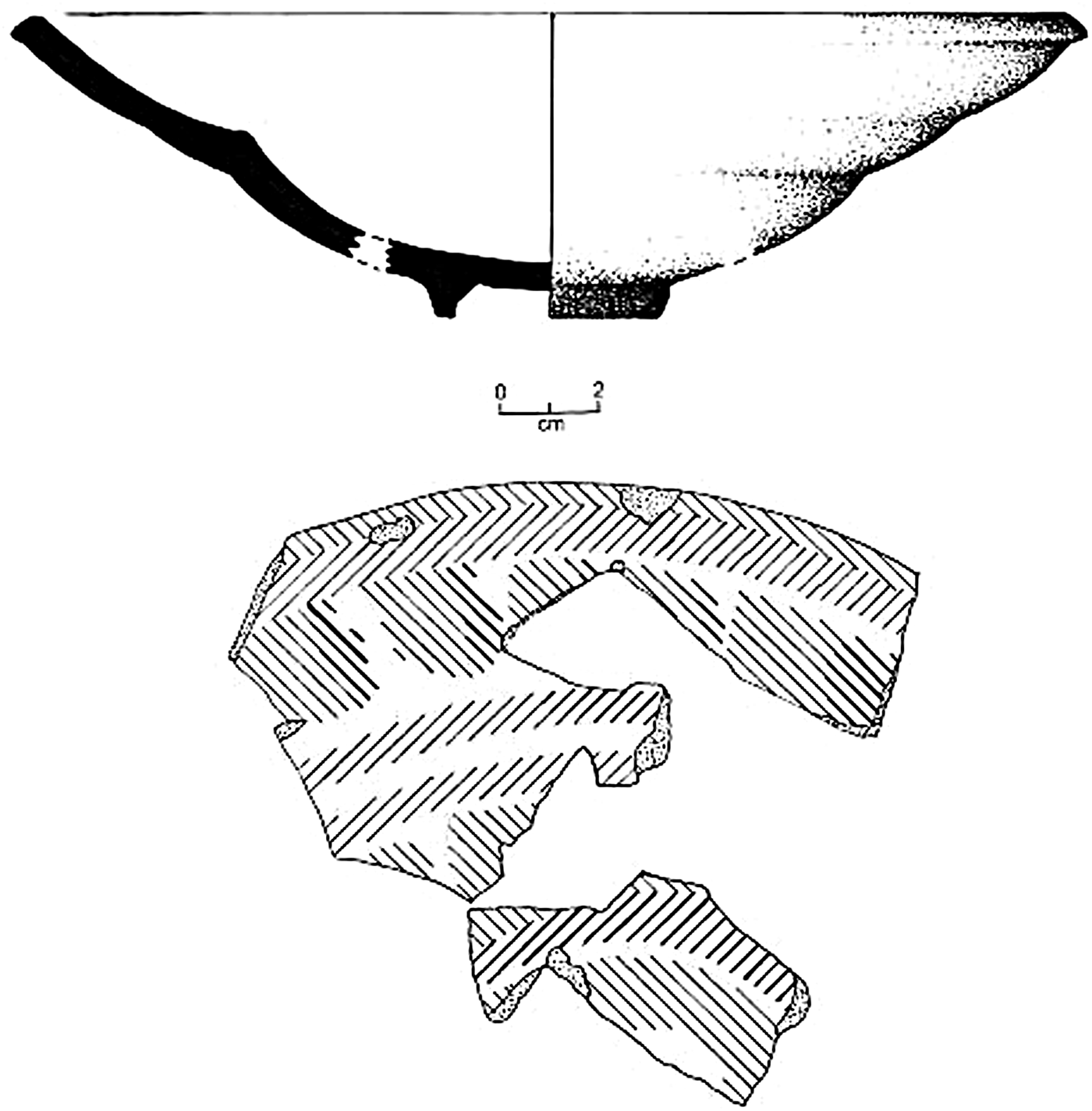
A partially reconstructible plato of Leonor Polychrome, circumference 22 cm diameter, was recovered at Structure T-35 (Figure 13). In addition, a small fragment of a ring base of a Yayal Blue-on-White cup or escudilla was found. Yayal is a type of “Morisco ware” produced in Andalucía (Spain) in the sixteenth century, and the foot ring suggests it was a late century product (Deagan Reference Deagan1987:55, Figure 4.24).
Leonor Polychrome plate, Structure T-35, Tayasal, Guatemala.
Of particular interest are hybrid wares, locally produced vessels appropriating attributes of European vessel styles. One of these is Ixkamik Unslipped type, which was increasingly popular in the Colonial period. Ixkamik has a fine, sandy paste with a thick dark core. It resembles the late indigenous Chilo Unslipped type in some general respects but is thicker walled, slightly better finished, and has light tan/gray (rather than reddish-brown) surfaces. It is likely that fragments of both types were noted in earlier surveys around Lake Petén Itzá (e.g., Cowgill Reference Cowgill1963; Chase Reference Chase1983), but they were largely ignored because the forms so closely resembled pottery made in the area in the mid-twentieth century (see Reina and Hill Reference Reina and Hill1978:141–145).
Hybrid wares are also known as colonowares, which were made by indigenous inhabitants in some areas of the Americas and by African slaves in others (Card Reference Card and Card2013:7; Cordell Reference Cordell and Card2013; Fennell Reference Fennell2011:19–23; Wheaton Reference Wheaton and Orser2002). These and other forms of hybridity at many early Spanish-colonial settlements often have been explained by intermarriage (Cobb and DePratter Reference Cobb and DePratter2012:456; Deagan Reference Deagan1973:61–64). Africans came into Petén in small numbers as conquistadors (Restall Reference Restall2003:51–63), and fugitive black slaves escaping English colonies in what is now Belize may have found their way to Petén as early as the 1720s, some settling in the region's missions (Schwartz Reference Schwartz1990:65–67). We have little reason to think that Ixkamik pottery in Petén was not made by Mayas, however, perhaps for trade with the Spaniards at the presidio or with Mayas who desired pottery in this style. Most of the priests who traveled from Yucatán were likely indigenous, and many of the “Spaniards” were criollos born in the Americas, all of whom likely had a taste for Spanish-style goods.
Colonowares and tin-enameled wares produced in Guatemala were local variants of the larger imported European styles, meaning that their production was, like that of colonowares, affected by the cultural entanglement. The presence in Petén of pottery produced in the highlands of Guatemala or central Mexico indicates long-distance movement of these fragile goods between these areas.
Fragments of “olive jars” or botijas are occasionally seen in excavations on Flores Island, and have also been recovered at the probable original mission location of San Jerónimo, on the Candelaria Peninsula across from San Bernabé. Botijas are amphora-like vessels long used in Mediterranean and trans-Atlantic commerce to transport a variety of dry, semiliquid, and liquid goods, such as olive oil and wine. Nevertheless, no botija sherds were encountered at San Bernabé. Wine for the sacrament at the Petén mission churches might also have been brought in in wooden kegs or goatskins.
The only slipped indigenous pottery so far identified at San Bernabé consists of the red-slipped Paxcamán ceramic group and its constituent types, which are most clearly associated with the Itzas throughout the Postclassic period. Aside from the nearly complete Picú Incised drum, recovered in a cache in the church, indigenous pottery mostly occurred as small collections of fragments of slipped and unslipped vessels in features.
Excavations at San Bernabé helped further define a contrast seen elsewhere at Tayasal. Caches, Itza burials, and other Postclassic- through Colonial-period constructions tended to have associated deposits of sherds from terminated ceremonial vessels placed as offerings above them. Such patterns were even observed inside the San Bernabé church. For reasons we cannot explain, the tripod supports of Paxcaman plates appear to have been particularly selected for these caches, but they did not constitute a majority of the sherds. The offering pattern changed between the Contact and Colonial periods, however. In Tayasal Group 23, a Late Postclassic/Contact-period complex, the sherds primarily included composite and effigy censers (Pugh et al. Reference Pugh, Sánchez and Shiratori2012:9). In San Bernabé, deposits contained high frequencies of Paxcaman Red, Pozo Unslipped, and Ixkamik Unslipped sherds. The difference between the Group 23 and San Bernabé deposits is the obvious absence of censers—“idols” to the Spaniards—in the latter, but both reveal a preference for ritual ceramics, with decorated (red-slipped) wares in the latter and censers in the former.
Red-slipped pottery of the Topoxté group, associated with the Kowojs, is absent at San Bernabé, although it did constitute a small percentage (c. 1%) of the ceramics in other parts of Tayasal (and on Flores Island). The Itzas' internal factions and the once Kowoj-allied Chakan Itzas may have remained quasi-independent after the conquest. Although Chakan Itza occupations have been identified on the Candelaria Peninsula, we cannot yet confidently identify ceramics specifically associated with this faction or with the Mopans.
Coins and Money
Two silver one-real cobs were recovered in excavations of residences at San Bernabé. One, from Structure T29, lacked a visible date. The other, found in Structure T35 (Figure 11), displays the Pillars of Hercules on the obverse with the letters “SVL T,” which is a partial stamp of the national motto of Spain, plus ultra or ‘further beyond’. Below the SVL are three numbers—“728”—indicating the year 1728. The reverse depicts the shield of Castilla y León. This coin weighs 3.1 g and was most likely produced in the mint at Santiago de Guatemala, which produced cobs until 1753 (Deagan Reference Deagan2002:255).
Not all Spanish coins were minted the same way. The peso de plata antigua, known as the “eight-real coin,” was of such high quality and circulation that it became the universal currency of the Americas and Europe and the preferred coin in many non-Spanish colonies and the early United States. The value of the peso de plata antigua was very stable in the seventeenth and eighteenth centuries. On the other hand, reales were frequently devalued—in 1642, the value of pesos changed from 8 reales to 10 reales and in 1772, 11 reales made up a peso de plata antigua (McCusker Reference McCusker1978:7, 99). An imaginary currency called the peso de cambio existed for accounting purposes. This peso was set at 8 reales de plata antigua; hence, when the value of the real dropped, so did the value of the peso de cambio. To make matters more complex, at the time of the occupation of San Bernabé, there was a second type of real, known as the real de vellon, which contained less silver and was worth half that of the real de plata antigua. It exchanged 20 to a peso de plata antigua and 15 to a peso de cambio (McCusker Reference McCusker1978:99–100). Finally, dishonest minters, along with clipping, filing, and use-wear, resulted in the loss of metal from coins and some exchanges ignored face values and considered only weight (McCusker Reference McCusker1978:98–99). It is most likely that the reales encountered in the excavations at San Bernabé were reales de vellon, but accounts would have been recorded in pesos de cambio. Both coins recovered at San Bernabé weigh below the legal requirements of 1535–1728 (3.4335 g) and 1728–1825 (3.383 g) (Craig Reference Craig2000:Table 2.1) and seem to have been clipped and filed.
The Spaniards suggested that the Maya possessed “money” in the form of beads (probably Spondylus) and cacao beans at contact (Landa in Tozzer Reference Tozzer1941:95,164). Nevertheless, many early interpretations of economic systems followed an evolutionary model, erroneously understanding indigenous systems as primitive forms of those practiced by colonialists (Thomas Reference Thomas1991:10–12). Even if cacao were used as a sort of currency, it could not fulfill the same functions as metal coinage because of its perishability. True money permits several complex phenomena: economic exchange networks that cover large spaces and occur at different times, extraction and storage of surplus wealth, credit/debt, “transformation of private property into capital,” and wage labor (Giddens Reference Anthony1981:117, Reference Anthony1979:105).
The cultural changes that occurred with the imposition of currency (both real and of account) at San Bernabé were likely equal to those imposed by the church, and tied this remote settlement into the global economy. First and foremost was the ability to transform labor into capital in the form of wage labor. Second, even when coinage was physically absent, transactions, debts, and taxes could be calculated via pesos de cambio. Prestige goods had already been undermined though the arrival of the “gift kits,” which were subsequently normalized though inflation; therefore, wealth storage and the purchase of Spanish luxury goods became the new status markers.
The recovery of coins indicates that San Bernabé had been integrated into the Spanish system of exchange. Occupants of San Bernabé working for the Spaniards were paid in reales (Caso Barrera Reference Caso Barrera2002:393–394; Schwartz Reference Schwartz1990:45) and used this currency to purchase both local and imported goods, as is evident in the household middens at San Bernabé. Maya cowboys were paid 12 pesos a year, which is very low compared to Spanish soldiers' pay of 108 pesos per year. To put this figure in perspective, soldiers had to pay 48 pesos a year for food (Schwartz Reference Schwartz1990:45). Although some Mayas were paid laborers, for many their experience with money was debt. Adult males under the age of 50 were taxed two pesos per year, which was paid in cash rather than commodities. As a result, many were subjected to debt peonage (Schwartz Reference Schwartz1990:39). Most labor such as farming was not conducted in the service of the Spaniards, though locally produced food and goods were sold to them. While it is nearly impossible to discern exchange in systems that do not involve distinct currencies, indigenous barter and gift economies almost certainly continued in the Colonial period.
Although the Spanish currency originated in Europe and was a salient symbol of the national economy, the mines that produced the metal and the mints that shaped the coins were located in Guatemala or Mexico. Thus, neither the coins nor the economies can be considered purely “European” with the intensification that accompanied early globalization. Nevertheless, Spanish currency did represent the Spanish empire. Unlike other states and their colonies, the Spaniards forbade the circulation of foreign coinage within their realm (McCusker Reference McCusker1978:98).
Other Goods
Surprisingly, grave goods were almost completely absent from the San Bernabé cemetery. Burial 12 included a blue glass bead as well as a small obsidian projectile point. The bead originally may have been included with the first interment in the sepulture rather than the more recently deposited individual. Glass beads, which might have been given to children who succeeded in religious education (Graham Reference Graham2011:23), are rare at Petén sites, compared with other Contact- and Colonial-period Maya settlements, and occurred more frequently in Structure T29 than in other buildings at Tayasal. The lack of beads and other Spanish objects in burials clearly differentiates the San Bernabé mission site from Tipu (Pugh et al. Reference Pugh, Sánchez and Shiratori2012:13).
Several burials included fragments of obsidian blades around the neck and crania. We are uncertain of their significance, but this seems to have been an indigenous practice. Small side-notched projectile points of obsidian and chert, which commonly occur in post-Late Classic-period communities throughout Petén (Meissner Reference Meissner2014), were also recovered in the residential area.
Excavations also encountered iron, including a lock, and a glass lens likely from a pair of eyeglasses. Eyeglasses appear to have been a common fashion accessory in Spain and likely in the Americas (Deagan Reference Deagan2002:223).
ANIMAL USE
The Spaniards brought a new suite of animals to the Americas beginning as early as 1494. Ship inventories list mares, asses, sheep, goats, calves, and chickens (Deagan and Cruxent Reference Deagan and Cruxent2002). Domesticated animals formed integral parts of Spanish efforts to establish stable colonies among the new peoples they encountered, and of the social and economic structure of the colonial system. The Spaniards established cattle ranches (estancias) for a stable sustenance base, extending the Iberian Peninsula's long medieval heritage of extensive cattle- and sheep-ranching (Alexander Reference Alexander2003:203–204; Bishko Reference Bishko1952; Farriss Reference Farriss1984:321–322; Schwartz Reference Schwartz1990:41). Many estancias held cattle as “a source of capital and collateral” rather than as a food source (Alexander Reference Alexander2003:205).
The Mayas may have acquired European domesticates through various means, such as gifts, exchange, inheritance, or even theft (Smith Reference Smith1987:122–124). Considerable information comes from Yucatán, where documents such as wills reveal variations in animal use: cows and a few horses were mentioned in Maya testaments from 1646–1835 in four communities, with pigs, chicken, and turkeys in only one (Restall Reference Restall1997:365). In Tekanto, cattle were listed as property by 1674, slightly later than horses (1661), but were not commonly mentioned in wills until the 1770s (Thompson Reference Thompson1999). Tribute requirements obliged some Maya communities to raise or even purchase European domesticated species. By the late seventeenth century, 81% of families in a village near Merida paid tithe for cattle, 40% paid for either horses or mules, and a small number of families had only birds or pigs (Patch Reference Patch1993:183). These findings are supported by archaeological evidence. Pens for pigs and poultry were identified in three communities in the Yaxcaba region during the Colonial period (Alexander Reference Alexander2004:133–134). Unfortunately, evidence of animal husbandry does not demonstrate the extent to which Maya households incorporated the animals into their subsistence and religious practices. Even when raising turkeys and chickens for tribute or as community property managed by Maya cofradías, indigenous groups may have consumed them only on special occasions such as feasts or during famines (Farriss Reference Farriss1984:167).
In the Petén lakes region, changes in animal use are visible in zooarchaeological assemblages only after the Spaniards gained a foothold in the region in 1697. Captain Martín de Ursúa y Arizmendi and his soldiers brought hundreds of mules and horses, along with 21 dogs (and “400 hens to be dried and stored in jars”) to their encampment (Jones Reference Jones1998:263, 487n78). In 1699 Ursúa brought more than 1200 “head of cattle and horses” to establish ranches (Villagutierre Soto-Mayor Reference Villagutierre Soto-Mayor, Wood and Comparato1983:363). By 1704, the royal estancia of Petén had 200 head of cattle and 40 horses (Jones Reference Jones1998:398). Private ranches were soon established in savannas north of San Andrés and in the south near Santa Ana, and stock-raising became “the major commercial agrarian activity in Petén” until shortly after independence (Schwartz Reference Schwartz1990:53).
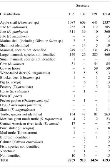
Faunal remains from Mission San Bernabé and Tayasal consist of 14,537 bone and shell fragments (25,957 g). One third of the remains comes from Structures T35, T29, and T31 (n = 4,593 in Table 4). Colonial-period fauna from Structures T30, T1121, and T1122 are not yet analyzed or not present in sufficient quantities to be included in this discussion.
Number of bone fragments identified, by Tayasal structure.
Note: Taxonomic categories are listed in order of most to least abundant (e.g., invertebrates, mammals, reptiles, fish, vertebrates, and bone fragments not yet assigned to a category).
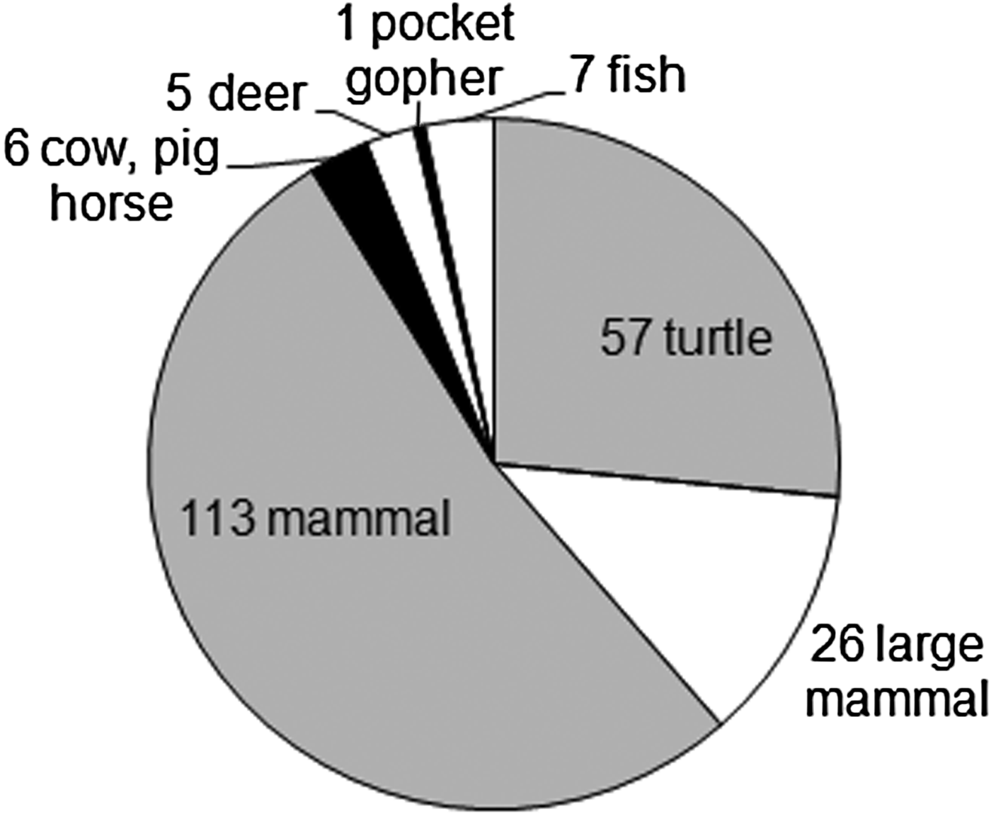
All three structures evidence use of domesticated European animals, with Structure T31, the mission church having at least one horse (Equus caballus), a pig (Sus scrofa) aged < 3 years, and either a European or native breed of dog (Figure 14). A range of native species is also present, including white-tailed deer, pocket gopher, caiman, and fish species represented by hundreds of cranial and postcranial bones not yet included in the assemblage totals. Bone fragments of multiple cichlids, likely those of mojarra native to Lake Petén Itzá, were identified in flotation samples taken from the cache adjacent to the large column base (Feature T31-13). The presence of cranial and vertebral elements reveals that parts of whole fish were deposited along with mammal, turtle, and shell fragments, some of which were burned.
Vertebrate fauna, Structure T31, Tayasal, Guatemala.
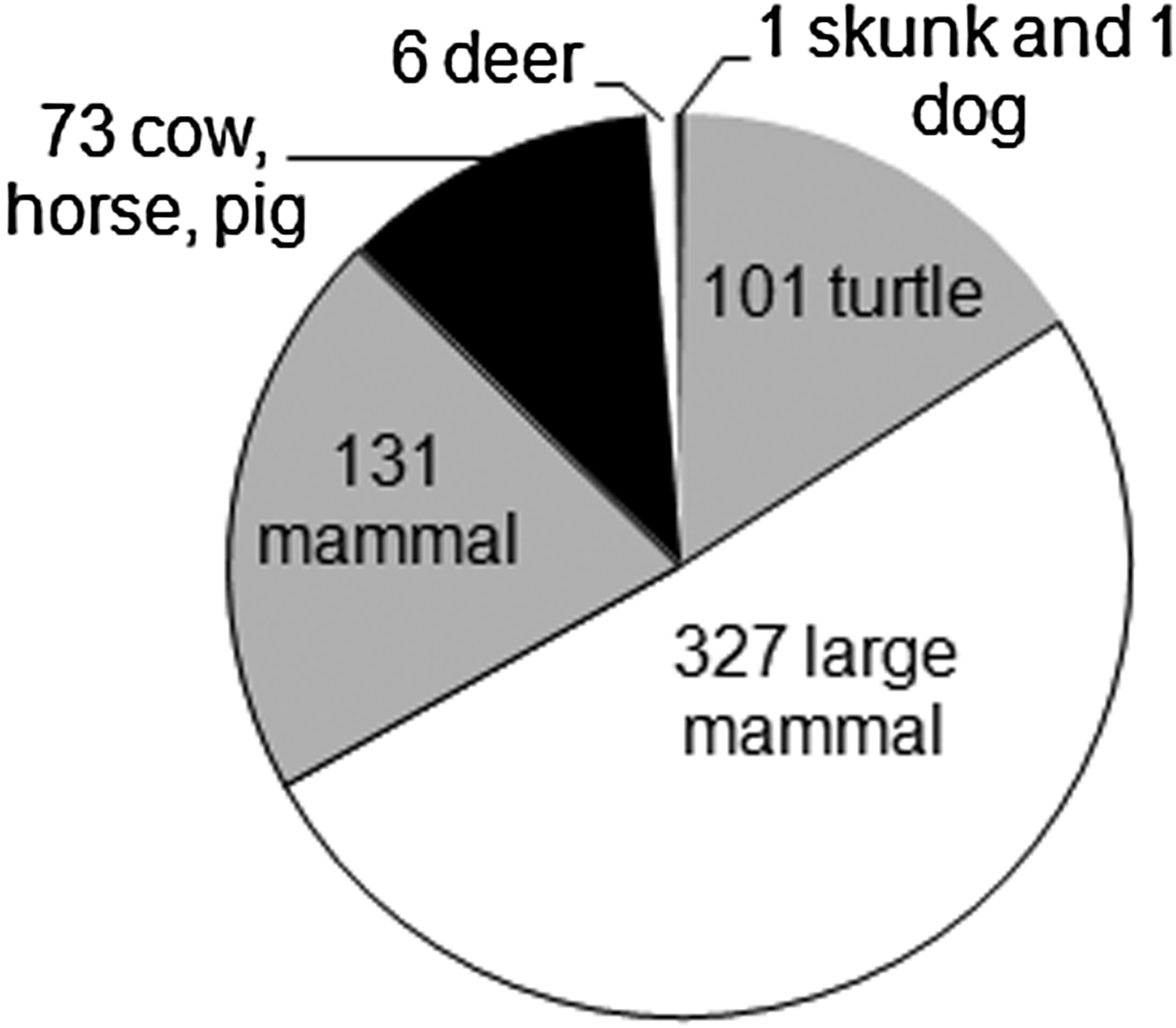
Domesticated animal remains also have been identified at the two residences at San Bernabé, including cow (Bos taurus), pig, and horse. Structure T29, a relatively high status residence, has the most evidence for use of introduced species (Figure 15). A minimum of three cows are present, based on duplicate lower left third molars, which also show that each was an adult animal, and duplicate left radii (lower forelimb) fragments. Other parts of cows in the assemblage include tarsals and phalanges, with fracture patterns indicating that most limb shaft bones were likely broken during food preparation. The remains of an adult and juvenile pig also were present, but this species was only identified by its dentition.
Vertebrate fauna, Structure T29, Tayasal, Guatemala.
Wild game is present in some of the same contexts of Structure T29, including a minimum of one whitetail and one brocket deer, and at least one pond slider and Mexican giant musk turtle. Multiple individuals may be represented by unduplicated bone elements. Turtle fragments account for approximately 7% of the bone fragments in Structure T29, in proportions equal to those found in Structures T35 (7%) and T31 (6%). The number of species identified appears to relate directly to the size of the assemblage in each structure, with all four genera present in the structure with the most bones identified (T35), two genera identified in T29, and only one in T31.
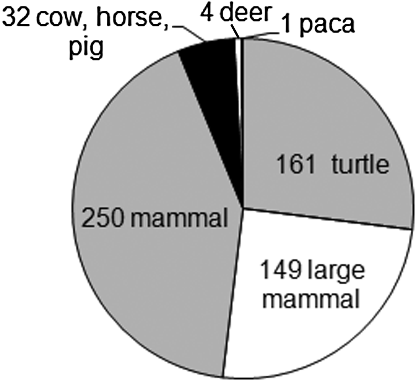
Fewer domesticated animals were found associated with Structure T35 (Figure 16), although nearly twice the number of specimens has been classified. Cow remains consist mainly of teeth, and an unfused metapodial epiphysis fragment indicates the presence of one juvenile. More than half of the classified specimens are snails and these, plus the remains of turtle, deer, and smaller mammals such as paca, demonstrate continuation of traditional subsistence practices.
Vertebrate fauna, Structure T35, Tayasal, Guatemala.
It is evident that the residents of San Bernabé continued to rely heavily on traditional lacustrine resources and terrestrial game. In parts of the lowlands outside direct colonial control, wild game remained the principal fauna exploited by the Mayas into the nineteenth century (Emery Reference Emery1990; Freiwald Reference Freiwald2007, Reference Freiwald and Pugh2013; Palka Reference Palka2005). In the environment of Lake Petén Itzá, it is not surprising that snails were commonly consumed.
Pomacea sp. (apple snail) shell fragments (n = 2,337) represent 217 snails in Structure T29 (641 fragments), 173 snails in Structure T35 (1,087 fragments), and 280 snails in Structure T31 (609 fragments), based on duplicate elements of the shell aperture. These large snails are collected along the marshy shoreline of the lake. Jute snail shells represent 18% of the remains (n = 845), and nearly all represent whole smooth-shelled jute (P. indiorum) or sculptured-shell jute (P. glaphyrus and P. largillierti). These are prepared either by removing the apex of the shell or by punching a small hole in one or more of the whorls to remove the snail (e.g., Freiwald Reference Freiwald and Pugh2013; Healy et al. Reference Healy, Emery and Wright1990:179; Keller Reference Keller and Robin2012). Colonial-period residences appear to have acquired jute snails from difference sources. Those in colonial remains of Structure T35 consist of 55% sculptured shell type (P. glaphyrus), reportedly found today south of the lakes. Structure T29 residents consumed mainly (92%) locally-available smooth-shelled jute (P. indiorum), along with a small number of P. largillierti snails.
In sum, preliminary comparison of the faunal assemblages from the small sample of San Bernabé households suggests that they did not have equal access to European domesticates or chose not to use them to the same extent. We have no evidence that the lakes-region Mayas used chickens, sheep, or goats in the early Colonial period. Traditional native resources were still important, but some households may have accessed different catchments. Families with greater resources may have owned cattle as individuals or as household or family units, and investment in cattle also occurred at the community level. Some middens associated with the structures may have contained remains of meals shared with other mission residents.
CONCLUSIONS
Excavations at Mission San Bernabé recovered material indicators of all four of Michel Foucault's types of technology of domination (sign, power, self, and production). The mission church, Structure T31, was the reduction community's obvious focal sign of Catholic religious and political domination. As the primary agent of Spain's entanglements with its colonial subjects, the Catholic Church throughout the Americas was at the center of efforts to convert indigenous peoples from heathenry to civilized order. The church building itself exemplified the truth/good which the baptized strived to replicate. The patterned human remains buried under the San Bernabé church divulged policía cristiana even in death. Although the rarity of indigenous incense burners reflects the Spanish authorities' successful curbing of visible local religious practices, Maya spiritual beliefs did not end with the conquest—even the Church, the center of Spanish power, incorporated indigenous practices. Catholic saints replaced some local systems of identity patrons, but these and other religious objects and practices were also generally syncretic (Reina Reference Reina1962; Watanabe Reference Watanabe1990:135–139). Over the course of the colonial process, former regional ethnic identities were largely replaced by localized identities based in particular mission communities (Schwartz Reference Schwartz1990:75)—perhaps in association with the balkanization of the political structuring of the b'atab'ob.
The Spaniards adapted existing social, political, spatial, and material realities to suit their purposes, transforming existing relations and identities based on ethnicity, politics, and gender. Mission settlements forced the intermingling of indigenous ethno-political identities that were often mutually hostile: the label “Itza” incorporated several sub-groups, and all inhabited mission settlements along with Kowojs, Mopans, other Maya groups, and later, with Spaniards/criollos and Africans. Thus monolithic concepts such as “indigenous” obscure these sorts of entanglements and subsequent ethnogenesis, especially when both indigenous and settler groups have internal factions. Many of these factions were melded in the entanglement, and—at the same time—new identities were formed. One of San Bernabé's b'atab'ob, for example, was apparently Mopan, and might have occupied Structure T29, given that this building and its artifacts suggest a person of higher status, perhaps a maestro cantor. Such “foreign” leaders often exploited locals in a manner similar to the Spaniards (Schwartz Reference Schwartz1990:65).
San Bernabé was “bajo campana” of Nuestra Señora de los Remedios y San Pablo, Laguna del Itza. As in Yucatan, the priests lived in the central settlement and traveled outward to conduct some rites in visita missions and mission occupants traveled to the cabecera for certain festivals (Hanks Reference Hanks2010:40–41, 60). Most Spaniards and other non-Mayas lived on the island, now known as Remedios (Schwartz Reference Schwartz1990:52). Central church rites involved more activities conducted by Spanish priests rather than indigenous maestros cantores, creating the sense that the central churches were closer to the divine (Hanks Reference Hanks2010:61). Moreover, the non-clergy Spaniards living in Remedios were considered spatially closer to righteousness and ideal policía cristiana, which helped justify their social positions and exploitation of indigenous peoples.
The Spaniards, both clergy and lay, sought to extract labor and surplus from the Mayas (Hanks Reference Hanks2010:94) by implementing numerous strategies revolving around money, ranches, and taxation. The reales found at Tayasal are salient reminders of a world currency, the Spanish economy, and taxation, but the human remains excavated from beneath the church were equally so. The human remains at San Bernabé reveal that the occupants of the mission experienced physiological stress and led lives involving hard physical labor to support Spanish demands and to feed themselves. Labor was short in Petén during the Colonial period and many Mayas living at missions fell into debt peonage (Schwartz Reference Schwartz1990:43). Spanish domesticated animals formed part of the local diet although most were likely sold to Yucatán. Currency, both in metal and in accounting ledgers, created a local economic system that allowed for the extraction of a little more surplus wealth. It also provided the infrastructure for an economic system allowing for wage labor, taxation, and debt. Nevertheless, impoverished Petén was never really a profitable part of the Spanish empire. Yucatán was considered backcountry in the colonial world. Petén was “even more remote” and very poor (Schwartz Reference Schwartz1990:39–40).
One wonders about the strategies underlying implementation of the Spanish economic system. One obvious early tactic was the use of “gift kits” to form exchange networks, transform local economies by creating new systems of value, and replace existing luxury goods. Nevertheless, the value of gift kits would only be constant if distance between the colonist and the local remained constant and contact occurred only periodically. In situations where contact increases through time, formerly scarce objects can become increasingly available to the larger population. This “trickle-down” effect can result in the weakening of the statuses projected by the goods' consumption/possession, and they are transformed from inalienable goods to commodities (van der Veen Reference van der Veen2003:409–410). In other words, colonial powers used gift kits to create economic relationships with local groups and to encourage policía cristiana, but as gift value ultimately broke down so did many aspects of indigenous prestige systems. These systems did not completely disappear, but Spanish colonialism involved the emplacement of new systems. Chief among them was participation in the Church and the Spanish sociopolitical economy, which clearly established the Mayas as a subordinate caste.
Still, many aspects of life in missions did not follow a Spanish pattern. The material culture of San Bernabé differed from that of the pre-contact occupants of Petén, yet in the community outside the church indigenous practices seem far more common than Spanish practices. This finding corresponds to observations at Spanish missions in California (Farnsworth Reference Farnsworth1992:33). In general, although the adoption of Spanish objects and behaviors was pervasive throughout Latin America, local manifestations of appropriation were unique (see Cobb and DePratter Reference Cobb and DePratter2012:447). Similarly, the private domain of households in Spanish-colonial communities tended to be less impacted by Spanish praxes, but behavior in public outside of the residences more rapidly conformed to Spanish styles (Deagan Reference Deagan2003:7).
In San Bernabé household contexts, cultural patterns remained largely unchanged, although subtle shifts are evident in indigenous ceramics and fauna. For example, Itza diagnostic ceramics certainly far outnumbered tin-enameled wares and stone tools were much more common than metal tools. Nevertheless, transformations such as Spanish-style details on ceramics produced using indigenous pastes, and incorporation of European fauna, mortuary behaviors, and Spanish currency, indicate that the Itzas and other groups at San Bernabé had begun to appropriate some Spanish practices. Although production was often centralized—a technology of domination—Spanish styles were not immune to the fluidity of cultural entanglement. They were also transformed, as is evident in regional variations in tin-enameled ware decoration.
Thus, Spanish-style artifacts found at San Bernabé and other mission sites in Petén and elsewhere are not just by-products of colonialism; these objects were critical components in the establishment and maintenance of exploitive relations. At the same time, the unique manner in which the objects appeared at San Bernabé reflects indigenous creativity and emerging ethnogenesis within the colonial context.
Preoccupations with Classic-period Maya “grandeur” and false notions of European technological determinism reflect romanticized images of vanishing peoples abandoning vast cities to jungle encroachment. The Mayas did not disappear or become less authentic during the Colonial period; changes in material culture do not necessarily correspond to changes in social identity (Cusick Reference Cusick and Cusick1998:135). Although some material expressions such as massive temples, codices, and images of gods disappeared, many practices continued and some were incorporated into the daily lives of the Spaniards. Material transformations cannot be relegated to acculturation or simply accidental transmission of traits, as materiality was a strategic component of Spanish colonialism. The appropriation of material goods by local groups was likely more effective than military force in entangling the Mayas with the foreigners, and these objects, along with promises of protection and access to religious “truth,” bound Maya peoples into the colonial system.
RESUMEN
Los españoles establecieron la misión de San Bernabé en Petén, Guatemala, pocos años después de la conquista de Petén en 1697, con el fin de ayudar a controlar a las poblaciones indígenas locales. Las investigaciones recientes del Proyecto Arqueológico Tayasal han revelado detalles sobre las relaciones entre los mayas y los españoles. En este artículo interpretamos los procesos del enredo (“entanglement”) entre los españoles y los mayas en la misión por su cultura material y por los cuatro tecnologías de dominación descrito por Michel Foucault (Reference Foucault, Martin, Gutman and Hutton1988:18): el poder, los símbolos, el sí mismo (“the self”) y la producción.
Se sabe que la adopción de los comportamientos y objetos españoles se generalizó en toda América Latina, pero las manifestaciones de apropiación local fueron únicos (adaptación de Cobb y DePratter Reference Cobb and DePratter2012:447). Asimismo, el dominio privado de los hogares en las comunidades de las colonias españolas tiende a ser menos afectado por las prácticas españolas pero el comportamiento en público, fuera de las residencias, responde conforme a los estilos españoles (Deagan Reference Deagan2003:7). San Bernabé ha mostrado patrones culturales domésticos que se mantuvieron prácticamente sin cambios. Aunque, los únicos cambios que se han logrado identificar son los obtenidos del análisis de la fauna y la cerámica indígena. Por ejemplo, los diagnósticos de cerámica itzaes superan las concentraciones de cerámica esmaltada de estaño, al igual que los utensilios y herramientas de piedra fueron mucho más comunes que las herramientas de metal. Sin embargo, las transformaciones tales como; los detalles de estilo español en la producción de cerámica con pasta indígena, la incorporación de fauna Europea, procedimientos mortuorios y tipos de moneda española indican, que los Itza y otros grupos en San Bernabé habían comenzado a practicar las actividades españolas.
Se entiende como misión a los asentamientos que entremezclan las identidades indígenas etno-políticas que a menudo se encontraban en conflicto o eran mutuamente hostiles, de tal manera que se conserva íntegro el concepto del significado “indígenas” pero se ocultan los tipos de entrelazamiento cultural y la etnogénesis que sobrevino. Tanto los indígenas como los grupos de colonos tenían facciones internas. Muchas de estas facciones se enlazaron y al mismo tiempo formaron nuevas identidades.
Como el principal agente de relaciones entre España con sus súbditos coloniales, la Iglesia tanto en San Bernabé como en toda América fue el centro de cada uno de los esfuerzos por convertir a los pueblos indígenas del paganismo al orden civilizado (cristianismo). Como parte de ese esfuerzo, los españoles se adaptaron a las realidades sociales, políticas, espaciales y materiales existentes, para acoplarse a estos propósitos se transformaron las realidades y relaciones existentes e identidades basadas en la etnicidad, la política y el género. Las creencias espirituales de los mayas no terminaron con la conquista sino que se incorporó las prácticas indígenas con las de la iglesia formando de tal manera un nuevo concepto, a partir del entrelazamiento entre las dos culturas.
Los mayas no desaparecen o se convierten en menos auténticos durante el período colonial. Aunque, algunas facciones de la cultura material como los enormes templos, códices e imágenes de dioses desaparecieron, al igual que muchas prácticas. Otras en cambio fueron consignadas e incorporadas en la vida cotidiana de los españoles. Las transformaciones materiales no pueden ser relegadas a la aculturación o simplemente a una accidental transmisión de rasgos, tal como la materialidad fue un componente estratégico del colonialismo español. La apropiación de los bienes materiales por grupos locales fue probablemente más eficaz que la fuerza militar en las interrelaciones de los mayas con los extranjeros, y estos objetos, junto con promesas de protección, fue lo que instaló el sistema colonial en los pueblos mayas.
ACKNOWLEDGMENTS
This research was supported by the National Science Foundation (BCS-0917918 and BCS-1037927), Queens College of the City University of New York, the Research Foundation of the City University of New York, and the Wenner-Gren Foundation. We are grateful to the community of San Miguel, the Centro Universitario del Petén, the Archivo General de Indias, Museo de América, Madrid, and the Instituto de Antropología e Historia for their help. We would also like to specifically acknowledge Carlos Sánchez, Evelyn Chan, Justin Bracken, Alexandra Brackett, Miguel Cano, Adolfo Coloch, Sulma Cortez, Francisco Enriquez, Bayron Hernández, Pablo Lizano, Elsa López, Rachel López, Erdozain López, Marta Perea, and Miriam Salas for their hard work in the field and laboratory. Insightful comments and critiques by three reviewers are much appreciated.