

INTRODUCTION
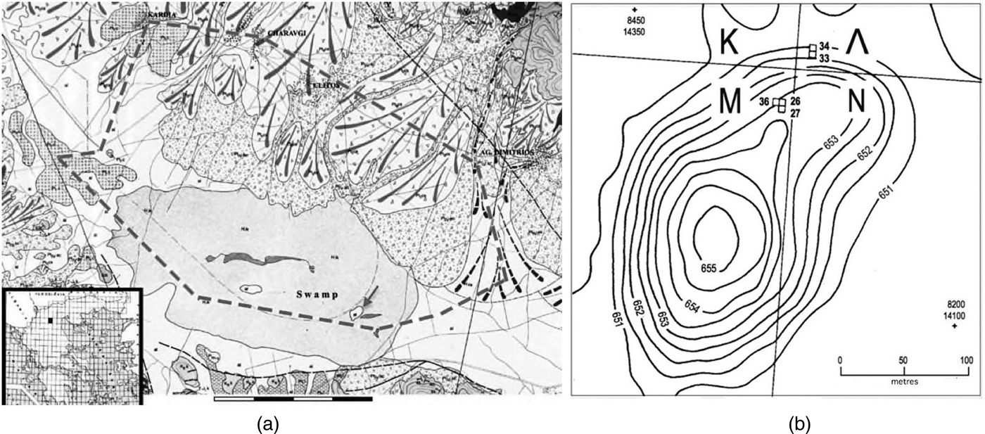
Megalo Nisi Galanis (MNG;Footnote 1 40o 37′ 84″ N, 21o 86′ 94″ Ε) is a large, c.8.5 hectares, Neolithic and Bronze Age mound site located on the floor of an inland basin in west Macedonia, Greece, at 653 ± 2 m a.s.l. (Fig. 1a). The maximum thickness of its anthropogenic deposits is estimated to about five metres (Fig. 1b). In recent centuries, if not for a good deal longer, the mound was surrounded by a marsh (hence the name ‘Nisi’, i.e. island). The marsh, known since Ottoman times as Sarigiol, was drained in the 1950s, and the reclaimed land was allocated to local farmers. At the same time a lignite strip mine began operating in the northern part of the basin, providing fuel for an electricity power plant. Since then the power plants have multiplied and the mine has been expanding in several directions, including the direction of MNG. In the mid-1980s G. Karamitrou-Mentesidi, then head of the Archaeological Ephorate for the area of Kozani, published a detailed catalogue of prehistoric sites in the basin that were threatened by the advancing mine. The catalogue contained precise topographic information about each site as well as details about its chronology based on surface finds (Karamitrou-Mentesidi Reference Karamitrou-Mentesidi1986). This was the dawn of a new era for the archaeology of the Sarigiol basin (ever since better known among archaeologists as Kitrini Limni; see Supplementary Materials [henceforth SM] Text 1). Systematic surveys and excavations began in 1987 and intensified in the following decades (see summary of results in Karamitrou-Mentesidi Reference Karamitrou-Mentesidi, Stefani, Merousis and Dimoula2014). In the meantime, the mine and the heaps of removed and redeposited spoil have radically transformed the topography of the northern and western quarters of the basin.
(a) The main part of the Kitrini Limni basin. Shaded area (marked ‘Swamp’) is the area formerly occupied by the Sarigiol marsh. Arrow points to MNG, the contour of which is also shown. The thick dashed line marks the projected extent of Notio Pedio (South Field), the main strip mine in the basin. Scale is 4 km. The basin's sole outlet lies in the northwest (upper left corner of figure). Map after Antoniadis, Mavridou and Gentzis Reference Antoniadis, Mavridou and Gentzis2005. (b) Contour map of Megalo Nisi Galanis with locations of the excavated Λ and M trenches. Elevations in m a.s.l.

Following Karamitrou-Mentesidi's Reference Karamitrou-Mentesidi1986 publication, excavations at MNG were conducted by the Archaeological Service in 1987–9 and again in 1993. The first author of the present article was asked in 1987 to organise and supervise the Kitrini Limni fieldwork in its early seasons. Besides annual reports in Greek, summaries of principal results have appeared in several places (e.g., Andreou, Fotiadis and Kotsakis Reference Andreou, Fotiadis and Kotsakis1996, 568–70; Fotiadis et al. Reference Fotiadis, Hondroyanni-Metoki, Kalogirou, Ziota, Hiller and Nikolov2000; Fotiadis, Greenfield and Fowler Reference Fotiadis, Greenfield and Fowler2005), while the faunal and the ceramic evidence from the seasons 1987–9 have received book-length treatments (Greenfield and Fowler Reference Greenfield and Fowler2005; Kalogirou Reference Kalogirou1994). The ceramic evidence in particular, including the finds of the 1993 season, received detailed attention in Fotiadis et al. (Reference Fotiadis, Hondroyanni-Metoki, Kalogirou, Ziota, Hiller and Nikolov2000). Here we review that and other evidence in the light of research findings that were unavailable in 2000, including six new radiocarbon dates, and we incorporate data from our analyses of other categories of artifacts. We also present previously unpublished ceramic and radiocarbon evidence for human presence at the site in the Early Neolithic, and we bring into the discussion insights from recent fieldwork by the Archaeological Service in other sites of Kitrini Limni.
THE EXCAVATION AND SURFACE SURVEY OF MEGALO NISI GALANIS
Methods
As shown in Fig. 1b, five 4 × 4 m trenches were sunk in the northern periphery of the mound. Two of them, Λ33 and Λ34, were set out at the very edge of the prehistoric settlement, where, as anticipated, cultural deposits were thin and became rapidly thinner from south to north. The other three trenches, M26, M27 and M36, were set 2.0–2.5 m higher up the mound's northern slope. The earth was removed in passes, i.e., units of variable extent and thickness, intended to observe pedological boundaries or at least to minimise transgression of such boundaries. We monitored the texture of the sediments removed with LaMotte field kits and employed the results in interpreting the excavated deposits (see examples in Fotiadis Reference Fotiadis1988, 43–6). All sediments were screened through one-centimetre dry sieves, and variable (in general, small) portions were water-sieved. Excavation was as a rule carried out by archaeology students, with workmen assigned to the sieving and the heavier tasks. Parts of trenches M26, Λ33 and Λ34 were excavated to the bottom of the anthropogenic deposits and proceeded beyond, removing the top 3–25 cm of the natural sediments at the base of the anthropogenic mound (see below).
The excavation was preceded by a surface survey of MNG, sampling of surface artifacts and quantification of the results. The estimate for the extent of the site (8.5 hectares) is based on that quantification. Note that the excavated area is very small, about 1/1000 of the estimated site extent. The limitations imposed by that sobering statistic are fully respected in the ensuing discussion of the excavation results. In 1987 and 1988 we surveyed and sampled artifacts from three quarters of the site, the rest being inaccessible to us at the time. We implemented a systematic sampling strategy with a sampling ratio of 2.5 per cent and collected every kind of cultural residue. Stones we surmised were used for flaked and ground stone tools were accorded special attention. The survey teams, working on their knees, were instructed to collect such stones down to the smallest detectable piece.Footnote 2 Flaked and ground stone, but also animal bone, potsherds and chunks of construction materials were present on the surface of MNG in strikingly high frequencies. We estimated, for example, the total population of ground stone pieces on the site's surface to be in excess of 1000 (Fotiadis Reference Fotiadis1988, 49), and the corresponding figure for flaked stone is estimated to around 7000. This profusion of surface cultural residue has been the result of deep ploughing, introduced to Sarigiol once the marsh was drained in the 1950s. Deep ploughing wreaked havoc to the top 0.5–0.7 m of the site's prehistoric deposits, mixing materials from several cultural phases (see below). It did not, however, disturb the lower deposits, residues of which are clearly underrepresented in our surface collection or are conspicuously absent. It is also noteworthy that much of the animal bone from the surface of MNG is burnt to various degrees. Our survey data indicated that this burning affected a large portion of the site, as one would expect from a settlement-wide conflagration. The study of the animal bone from the 1987–9 seasons confirmed the hypothesis of conflagration (bones of all taxa, including non-food taxa, were burnt). The study showed that more than 50 per cent of the bone material from the upper c.1 m of deposits in the M trenches had been burnt. By contrast, lower deposits were essentially devoid of burnt bones (Greenfield and Fowler Reference Greenfield and Fowler2005, 67–72).
Description of the excavated deposits
The anthropogenic deposits
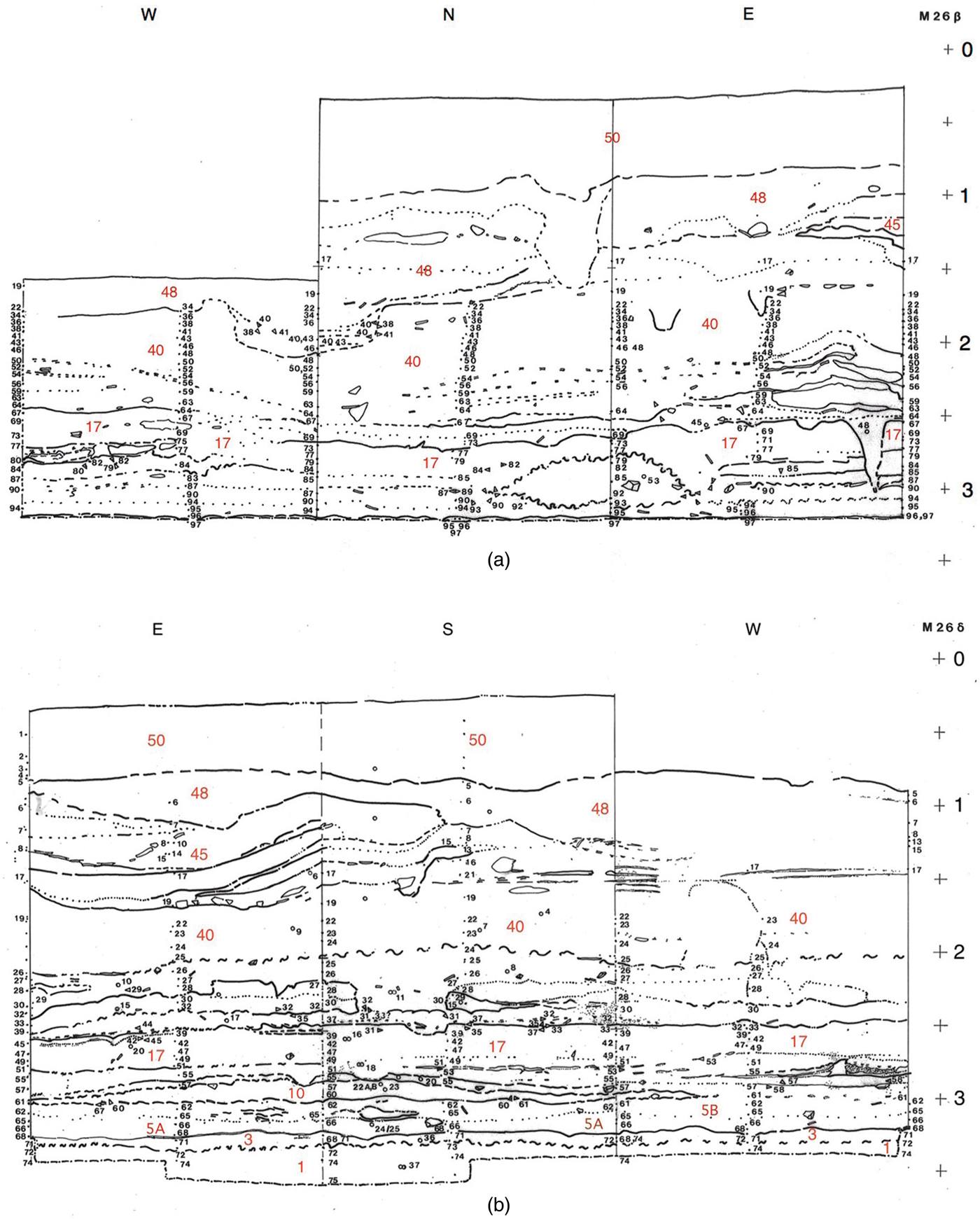
The deposits excavated in trenches Μ26, Μ27 and Μ36 are typical settlement debris and waste (typical, that is, for a Neolithic settlement in north Greece and adjacent areas). They cover the period from the advanced Middle Neolithic (MN) to the early Final Neolithic (FN)Footnote 3 but they also contain traces and ‘pockets’ of materials of both earlier and later phases (see below). The bulk consists of disintegrated structures in which earth and timber were the principal construction materials. The FN deposits (nos 45, 48 and 50 in Fig. 2) contain scores of fragments of house floors, walls and roofs with timber imprints that were solidified by fire. They also contain parts of small facilities the functions of which are unclear. Furthermore, the FN deposits, but not those of the earlier phases, are rich in carbonates and thus indurated. The concentration of carbonates in the higher parts of the site's stratigraphy is in part due to post-depositional processes, as indicated by the frequent presence of thick carbonate crusts on artifacts of all kinds. It also registers, however, a change in construction materials, namely the adoption of sandy, naturally calcareous sediments for house and facility construction. The change, noticed during excavation in 1989, has been confirmed by petrographic analysis of construction material samples from the relevant deposits (Joyner Reference Joyner1997). The possibility remains open, however, that the carbonate component found in construction materials was in some cases enhanced by the addition of lime.Footnote 4 Be that as it may, the boundary between the FN and the underlying Late Neolithic (LN) deposits is sharply distinct. This indicates either that accumulation ceased for some time in the area of the M trenches or, more likely, that the LN deposits are truncated, their top having been dug away before the FN deposits began accumulating (see also SM Text 2). Radiocarbon dates from the M trenches confirm the chronological hiatus implied by these observations, indicating a depositional vacuum of up to 350 years (see section ‘Radiocarbon dating’).
Stratigraphic sections (scarp drawings) of trench segments Μ26β (a) and Μ26δ (b). Scales in metres. Boundaries between deposits are graded from distinct and sharp (continuous lines) to distinct but diffuse (squiggles) to moderately distinct (dashed lines) to barely detectable (dotted lines). Small size numbers, mostly in columns, are excavation unit (pass) numbers. Larger size numbers (colour online) pertain to depositional units referred to in the text.

Cultural deposits below the FN ones have been divided into three chronostratigraphic units, LN, MN–LN transition, and MN (for details see SM Text 2 and Fig. SM2:1). Those deposits mainly consist of dark, clay-rich sediments, darker near the bottom of the sequence, but they also contain extensive lenses and parts of facilities from sandier, lighter-colour materials (e.g., deposits no. 10 in Fig. 2b and no. 13 in Fig. SM2:1). Their lowest part, from deposit no. 17 and below (Fig. 2a and b), contains quantities of the shallow, still water gastropod Planorbis sp. This suggests that the dark, fine-grain sediments of those deposits are lacustrine clays from nearby marshy areas, brought onto the site as construction material.
The deposits in trenches Λ33 and Λ34, by the north edge of the site, are radically different from those described above. Natural sediments here lay at depths between 0.4 and 1.5 m below the slope surface. The upper part of the sequence, with a maximum thickness of c.0.8 m, appears to be a dump of cultural residue derived from elsewhere in the settlement, for it contains a great quantity of small pieces of ceramics, stone artifacts and animal bone heaped in a pell-mell fashion (also disturbed by deep ploughing). Datable pieces belong to every phase from the Late Neolithic to about the end of the northern Greek Early Bronze Age (EBA). The dumping episode is therefore probably dated to about 1850 bc (see Maniatis Reference Maniatis, Stefani, Merousis and Dimoula2014, esp. 217, for this date; see also Arvaniti and Maniatis Reference Arvaniti and Maniatis2018, 769). The bottom part of the anthropogenic sequence, on the other hand, is only 0.1–0.4 m thick and contains few yet larger artifact fragments than the dump above (Fotiadis Reference Fotiadis1988, fig. 3a). Those fragments, moreover, are horizontally disposed and joins occasionally obtain among them. Last, nearly all potsherds from those deposits are of FN date. These observations lead to the conclusion that the lowest cultural deposits in the north edge of MNG formed in the Final Neolithic and survived essentially undisturbed by human intervention until their excavation in the 1980s. They were, however, subjected to the corrosive effects of the fluctuating, acidic water levels of the Sarigiol marsh: artifact edges are rounded, surfaces are worn (those of bone items have a peculiar polish) and potsherds have lost their original slips and burnishing. Such evidence also suggests that, at high stand, the Sarigiol waters encroached upon the lowest deposits in the periphery of the archaeological site (see also SM Text 1).
Natural sediments beneath the anthropogenic sequence
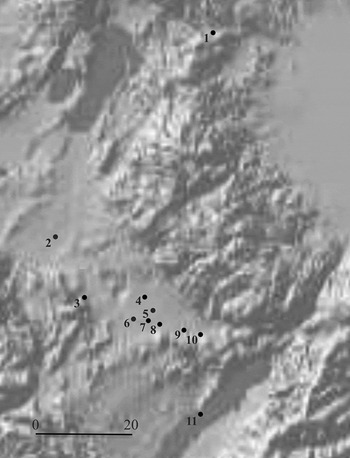
Natural sediments were reached and tested both in the Λ trenches and in trench M26, and the tests led to the same conclusion. The natural substratum in the area of MNG is a light-grey marl, free of sand and coarser particles (deposit no. 1 in Figs 2b and SM2:1). It was probably formed from clays transported in suspension by area streams and deposited at some distance beyond the stream mouths, in a low energy environment in the central part of the basin floor. Support for this inference comes from the electromagnetic survey we conducted on and around the MNG mound (Tartaron Reference Tartaron1989).Footnote 5 The age of formation of the marl deposits is unknown but need not be older than the last phases of the Pleistocene. At Nisi, a fen at 475 m a.s.l. near Edessa (c.75 km to the north of Kitrini Limni; Fig. 3), for instance, lacustrine marls dominate the Late Glacial part of the sequence (20,000–12,000 cal bp), although they are found alternating with peat deposits in the Holocene part as well. Pollen data for the Late Glacial at Nisi indicate a steppic, lightly wooded landscape, as expected for the period (Lawson et al. Reference Lawson, Al-Omari, Tzedakis, Bryant and Christanis2005).
Location map of sites in west Macedonia mentioned in the text. 1 Nisi; 2 Mavropigi-Filotsairi; 3 Pontokomi-Vrysi; 4 Kleitos; 5 Mikro Nisi Akrinis; 6 Nisi Pontokomis; 7 Megalo Nisi Galanis; 8 Megali Toumba Ayiou Dimitriou; 9 Xeropigado cemetery; 10 Kremasti-Kilada; 11 Servia. Scale bar 20 kilometres.

Between the marl and the bottom of the anthropogenic deposits at MNG intervenes a thin, 0.05–0.15 m, horizon of dark-brown clay (no. 3 in Figs 2b and SM2:1), comparable in key respects to the lacustrine clays that cover today the area formerly occupied by the Sarigiol marsh (Fig. 1a). Its dark colour indicates formation in a marsh environment rich in herbaceous vegetation, just as the case was with Sarigiol in recent centuries. Again, the precise age of this horizon is unknown, but an early Holocene date is most probable: the horizon was certainly in place by about 5600 bc,Footnote 6 for in trench M26 it is buried directly under cultural deposits dated by 14C to that time (see below). The settlement at MNG was established on that horizon and was throughout its career surrounded by dark clayey sediments, nutrient- and organic matter-rich, relatively moist and thus favourable to Neolithic farming.
Many other Neolithic settlements in Kitrini Limni are likely to have been founded on that privileged horizon. The evidence from Kleitos, a fully excavated LN and FN site at 660 m a.s.l. in the northern periphery of the basin floor, is a case in point. Here again, a distinct clay horizon was found sandwiched between the anthropogenic deposits (above) and light-grey marl (Ziota Reference Ziota, Stefani, Merousis and Dimoula2014, 327–9).
Let us briefly return to the FN deposits and their sand content. Our (admittedly crude) particle size analyses of FN construction materials indicated the presence of sand in percentages around 50 per cent or higher (see above, and Fotiadis Reference Fotiadis1988, 43–6). Our observations regarding natural sediments beneath the anthropogenic deposits at MNG show that sandy sediments were unavailable in the immediate vicinity of the site. Where did the sand of the FN deposits come from? Today, sand can be found in abundance in the bedload of watercourses originating in the uplands around Kitrini Limni and debouching in the basin floor at distances between two and five kilometres from MNG. In the Final Neolithic those distances might have been a good deal shorter; still, sandy sediment for building would have to be transferred to the site. The technology involved in such transfers is at the moment uncharted.
The Early Neolithic at MNG
The evidence from the excavated deposits
‘The earliest 20 cm of anthropogenic deposits [at MNG] formed at the time when red slipped pots, typical of the Middle Neolithic known from Servia and other sites, were still extensively used.’ This statement, by Fotiadis et al. (Reference Fotiadis, Hondroyanni-Metoki, Kalogirou, Ziota, Hiller and Nikolov2000, 218), must now be moderated. The lowest anthropogenic deposits encountered in trench Μ26, those immediately above the natural dark clay horizon, indeed accumulated in the advanced Middle Neolithic, as is shown by the bulk of the ceramic potsherds they contain (more than 500 pieces), and this attribution is corroborated by the sequence of 14C dates. Yet the same deposits also contain a handful or two of potsherds that are dateable to the Early Neolithic (EN). Those potsherds are very small and their surfaces are in general worn. They include: an unmistakable ‘Proto-Sesklo’ rim, probably from a cup, made from a fine clay body, burnished on the exterior, painted on the interior and fired to a brown colour; one more, tiny ‘Proto-Sesklo’ rim with orange slip on the exterior and interior, made from a fine, yet micaceous clay body; three sherds with different types of impressed decoration probably done with a fingernail; one rim from a deep bowl with a diameter of 20 cm made from a fine-clay body with some organic material, painted on the exterior with hatched ‘white-on-red’ inverted triangles ‘hanging’ from the rim; possibly a second sherd with similar decoration, but from a closed pot; a couple of sherds with painted patterns (e.g. two parallel rows of thick zigzag lines just below the rim or variations thereof); and, last, six or seven potsherds covered with a white slip on the exterior, bearing less distinctive or minimally preserved linear decoration (e.g., a single zigzag line combined with dots) in red, orange and brown colours (Fig. SM3:1). This pottery is at home in the Early Neolithic of both west and central Macedonia as known from old and new excavations (see, e.g., Papadakou, Urem-Kotsou and Kotsakis Reference Papadakou, Urem-Kotsou and Kotsakis2011; Urem-Kotsou et al. Reference Urem-Kotsou, Dimoula, Elezi, Papadakou, Papaioannou, Saridaki, Siamidou, Silva, Tzemopoulou, Kotsakis, Sarris, Kalogiropoulou, Kalayici and Karimali2017; Yiouni Reference Yiouni, Rodden and Wardle1996), as well as in the Early Neolithic of Thessaly and the Balkans.
Such finds indicate the presence of EN deposits in an unexcavated part of MNG, beyond trench Μ26. The potsherds could plausibly have come to the area of M26 as the MN inhabitants of the site ‘cannibalised’ older anthropogenic deposits for their own purposes, e.g., for using the dirt so obtained as construction material.
A charcoal sample from the relevant stratigraphic unit in trench Μ26 (specifically, from deposit 5B; see Fig. SM2:1) was dated to the late seventh millennium bc (date Beta-098971). The charcoal could have derived from the same area and by the same process as the EN potsherds. This seems likely, but the possibilities must also be considered that the elevated age of the sample (mean age 6250 bc) is the effect of old wood or of a certain degree of contamination by autochthonous carbon (see section ‘Radiocarbon dating’ and SM Text 2).
Until the 1990s only one EN site was known in Kitrini Limni (Megali Toumba Ayiou Dimitriou; Fotiadis and Hondroyanni-Metoki Reference Fotiadis and Hondroyanni-Metoki1993, 19–20 and references therein). Surveys and excavations by the Archaeological Service have since 2000 added several new EN sites, some of them within the Kitrini Limni watershed, and others, such as Mavropigi-Filotsairi, beyond but not far from it (see Karamitrou-Mentesidi Reference Karamitrou-Mentesidi, Stefani, Merousis and Dimoula2014 for a synopsis and maps). It is noteworthy that some of the recently discovered EN sites, including Filotsairi (676 m a.s.l.) and Pontokomi-Vrysi (736 m a.s.l.), are located on terraces well above the moist horizons of the basin floor. In those sites agriculture would have necessarily been rain-fed.
No doubt yet other EN sites are awaiting discovery in Kitrini Limni and its neighbourhood. In short, far from being isolated, the pioneer EN community at MNG was part of a regional network of coeval communities.
Climate and the Early Neolithic in Kitrini Limni
Neolithic farmers first settled in west Macedonia c.6500 bc, as the 14C sequence from Filotsairi demonstrates (Karamitrou-Mentesidi et al. Reference Karamitrou-Mentesidi, Efstratiou, Kaczanowska and Kozłowski2015). Several other Neolithic sites in continental Greece have yielded dates of comparable age, i.e., between 6600 (or slightly earlier) and 6400 bc (see Maniatis, Kotsakis and Halstead Reference Maniatis, Kotsakis and Halstead2011; Maniatis Reference Maniatis, Stefani, Merousis and Dimoula2014, 207–8; Reingruber et al. Reference Reingruber, Toufexis, Kyparissi-Apostolika, Anetakis, Maniatis and Facorellis2017, 39–41; Perlès, Quiles and Valladas Reference Perlès, Quiles and Valladas2013). All such settlements, that is, were founded during the ‘climatic optimum’ of the early Holocene, characterised by rather moist conditions, wet winters and warm, dry summers (Peyron et al. Reference Peyron, Goring, Dormoy, Kotthoff, Pross, Beaulieu, Drescher-Schneider, Vannière and Magny2011). The colonisation process coincided with the first, ‘nascent’ or ‘weak’ phase of a climatic disturbance, of near-global sweep, known as the ‘8.2 ka cal bp event’ (Berger et al Reference Berger, Lespez, Kuzucuoğlu, Glais, Hourani, Barra and Guilaine2016, 1865–7).Footnote 7 Around the Aegean, the second, ‘marked’ phase of that event (6250–6100 bc) left a conspicuous signal in several kinds of environmental records, terrestrial (e.g., Berger et al. Reference Berger, Lespez, Kuzucuoğlu, Glais, Hourani, Barra and Guilaine2016, 1863–5), marine (e.g., Geraga et al. Reference Geraga, Ioakim, Lykousis, Tsaila-Monopolis and Mylona2010, 112–14) and lacustrine. Among the latter, the pollen and hydrological records from the Philippoi Marshes and other lacustrine settings in and around northern Greece indicate a reversal of the early Holocene ‘optimum’ conditions: a frequent incursion of the ‘Siberian High’ into the Aegean area, with a consequent drop, by more than four degrees, of winter temperatures, a near two degree lowering of summer temperatures, and a sharp decline in precipitation except in summer (Berger et al. Reference Berger, Lespez, Kuzucuoğlu, Glais, Hourani, Barra and Guilaine2016, 1865; Lespez et al. Reference Lespez, Tsirtsoni, Darcque, Koukouli-Chryssanthaki, Malamidou, Treuil, Davidson, Kourtessi-Philippakis and Oberlin2013, 41–2; Peyron et al. Reference Peyron, Goring, Dormoy, Kotthoff, Pross, Beaulieu, Drescher-Schneider, Vannière and Magny2011, esp. fig. 2; Pross et al. Reference Pross, Kotthoff, Müller, Peyron, Dormoy, Schmiedl, Kalaitzidis and Smith2009; Aufgebauer et al. Reference Aufgebauer, Panagiotopoulos, Wagner, Schaebitz, Viehberg, Vogel, Zanchetta, Sulpizio, Leng and Damaschke2012, 132 and fig. 5).Footnote 8
In continental Greece, human responses to that climatic downturn are in general elusive. At Dikili Tash, located on the edge of the Philippoi Marshes, a shift in the habitation area of the settlement has been plausibly interpreted as such a response (Lespez et al. Reference Lespez, Tsirtsoni, Darcque, Koukouli-Chryssanthaki, Malamidou, Treuil, Davidson, Kourtessi-Philippakis and Oberlin2013, 42–3; Berger et al. Reference Berger, Lespez, Kuzucuoğlu, Glais, Hourani, Barra and Guilaine2016, fig. 10). Elsewhere relevant high-resolution data are lacking. In Kitrini Limni and its vicinity, none of the several EN sites seems to have been abandoned as a result of the downturn. Rather, four of those sites, including MNG, have 14C dates within the ‘marked’ (culmination) phase of the 8.2 ka cal bp event. Relevant as this may be to the issue of human responses, far more detailed chronologies, as well as data on settlement and environment histories and on agro-pastoral practices, are essential before the impact of the 8.2 ka cal bp on the Kitrini Limni communities can be assessed.
The MNG Neolithic cultural sequence and later deposits: synopsis
As indicated above, in the area of the M trenches cultural deposits began accumulating in the advanced Middle Neolithic (c.5700 bc, according to the modelled radiocarbon sequence), incorporating in the process bits of material from the earlier, EN phase of human presence at the site. Accumulation continued, probably uninterrupted, until the early Final Neolithic. The hiatus recorded between the LN and FN deposits is plausibly attributable to the removal of the top of the LN deposits (see above and SM Text 2). In short, the site's Neolithic occupational history stratigraphically documented in the M trenches extends from the late seventh millennium to the late fifth millennium bc. The end of that 2000-year-long occupation perhaps coincided with the settlement-wide conflagration noted earlier. But this is hardly guaranteed by the data at our disposal: evidence relevant to the issue has been muddled by the practice of deep mechanical ploughing generalised after World War II.
More important, the area of the Λ and M trenches was not entirely deserted after the fifth millennium bc. The FN deposits in the M trenches, especially in their upper parts, those disturbed by ploughing (deposit no. 50 in Fig. 2), contain ‘pockets’ of later material datable to more advanced phases of the Final Neolithic and to the Early Bronze Age (see below, section ‘The ceramic sequence’). More EBA potsherds and a clay anchor (a late EBA type) were retrieved from the ‘dump’ deposits of the shallow Λ trenches, while three or four pieces from the same deposits may even date to the Middle Bronze Age (see Fotiadis and Hondroyanni-Metoki Reference Fotiadis and Hondroyanni-Metoki1993, 24–5 and fig. 4). It turns out, therefore, that the excavated area of MNG continued to be occupied, albeit thinly or discontinuously, long after the late fifth millennium, to about 1800 bc.
The abandonment of the Kitrini Limni basin floor in the later Holocene
Beside MNG, several other Neolithic settlements in Kitrini Limni preserve evidence for human presence in the Bronze Age as well. However, no new settlements were established during the latter period in or near the basin floor. In line with a pattern familiar from many other regions in northern Greece and beyond, EBA foundations were laid at higher elevations (cf. Karamitrou-Mentesidi Reference Karamitrou-Mentesidi, Stefani, Merousis and Dimoula2014, 235 table 1:a). In Kitrini Limni a deterioration of drainage may have contributed to that pattern, yet hard evidence is necessary before that idea is seriously entertained (see below). The only site established in the basin floor in the Bronze Age is the cemetery of Xeropigado, used from c.2400 to c.1700 bc (Ziota Reference Ziota2007; Maniatis and Ziota Reference Maniatis and Ziota2011). But the Xeropigado cemetery, four kilometres east-south-east of MNG, developed on dry ground that, thanks to the region's topography, has never been encroached upon by the Sarigiol marsh. This conclusion is firmly based on pedological evidence from the cemetery and its environs.
To return briefly to the suggestion that deterioration of drainage may have contributed to the abandonment of the basin floor in the late Holocene: deterioration of drainage, if it occurred, cannot be attributed to a climatic shift toward wetter conditions. Climate proxies for the relevant period, late fourth to early second millennium bc, indicate a trend toward a climate drier than before (see, e.g., Lespez et al. Reference Lespez, Glais, López-Sáez, Le Drezen, Tsirtsoni, Davidson, Birée and Malamidou2016; Finné et al. Reference Finné, Holmgren, Sundqvist, Weiberg and Lindblom2011; cf. Magny et al. Reference Magny, Vannière, Zanchetta, Fouache, Touchais, Petrika, Coussot, Walter-Simonnet and Arnaud2009). Still, deterioration of drainage in Kitrini Limni could have been induced by factors unrelated to climate. Tectonism, for example, could have resulted in subsidence and constriction of the basin's surface outlet (located in the northwest; Figs 1a and SM1:1). The basin is located in an area of low seismicity, yet dozens of low magnitude tremors have been recorded in its immediate vicinity during the twentieth century (see SM Text 1). Absence of long-term data preempts, however, discussion of the issue. A more tractable scenario is the following. Palynological records from Nisi, near Edessa, and a few lakes in west Macedonia suggest an expansion/intensification of agro-pastoral practices after 3000 bc (Lawson et al. Reference Lawson, Al-Omari, Tzedakis, Bryant and Christanis2005, 884–5 and references therein). Sizeable tracks of upland forests were cleared (by burning?) and turned into pastures. We expect that, as a result, erosion in the uplands would intensify, and its products, deposited downslope, could have choked the basin's outlet, thus causing an expansion of marshland. With time, in the late Holocene (perhaps increasingly in the course of the Historical era), such conditions would lead to the formation of the Sarigiol marsh as we know it from early twentieth century maps (see SM Text 1). We stress, however, that the sequence just described is intended as a model, not as factual history, especially since the date for the onset of forest clearing and upland erosion (c.3000 bc) is poorly constrained. A recent review of Holocene pollen and other evidence from Greece is in partial agreement with our model, but it also indicates no significant expansion of agro-pastoral practices in west Macedonia until about 2000 years ago (Weiberg et al. Reference Weiberg, Bevan, Kouli, Katsianis, Woodbridge, Bonnier, Engel, Finné, Fyfe, Maniatis, Palmisano, Panajiotidis, Roberts and Shennan2019, especially fig. 7).
Radiocarbon dating
Samples and techniques
Ten charcoal samples from excavated deposits were subjected to radiocarbon dating. Five samples were analysed at the Beta-Analytic company, four of them by the technique of Liquid Scintillation Counting (LSC), and a fifth sample, Beta-098971, by Accelerator Mass Spectrometry (AMS). The remaining five samples were analysed at the Laboratory of Archaeometry, National Centre for Scientific Research (NCSR) Demokritos, Athens, which uses the Gas Proportional Counting technique (GPC; see Maniatis, Oberlin and Tsirtsoni Reference Maniatis, Oberlin, Tsirtsoni and Tsirtsoni2016, 42).
All radiocarbon dates were calibrated using the calibration program OxCal v4.2.4 with the most recent atmospheric dataset IntCal13 (Reimer et al. Reference Reimer, Bard, Bayliss, Beck, Blackwell, Bronk Ramsey, Buck, Cheng, Edwards, Friedrich, Grootes, Guilderson, Haflidason, Hajdas, Hatté, Heaton, Hogg, Hofmann, Hughen, Kaiser, Kromer, Manning, Niu, Reimer, Richards, Scott, Southon, Staff, Turney and Van der Plicht2013). Bayesian analysis was performed with the models available at the OxCal v4.2.4 (Bronk Ramsey Reference Bronk Ramsey2009a). The dates were treated with the outlier model described by Bronk Ramsey (Reference Bronk Ramsey2009b) for detecting and marking possible outliers, but no problems in regard to this were found.
Results
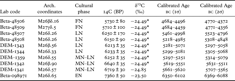
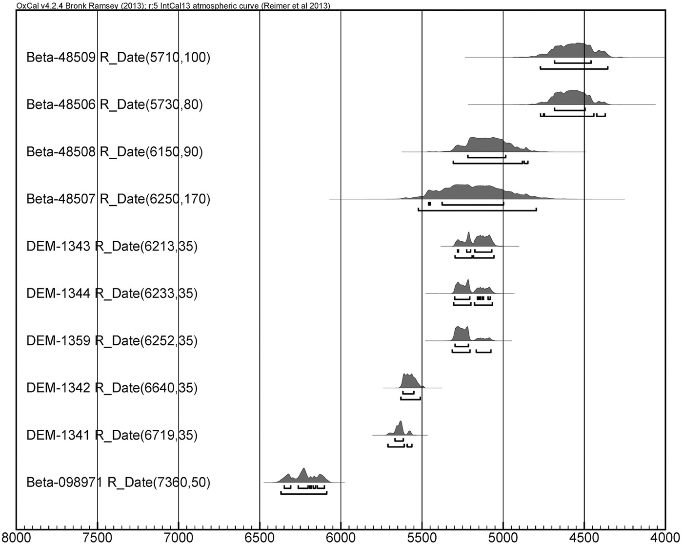
Table 1 presents the results of the radiocarbon dates of the samples with their archaeological coordinates and cultural phases. The calibrated dates are shown with both 1σ (68.2 per cent) and 2σ (95.4 per cent) probability without any modelling or statistical treatment. As can be seen, some dates have a rather large error bar as a result of the small initial amount of the sample. A calibration multi-plot of all the dates unmodelled is shown in Fig. 4.
Samples, coordinates, cultural phases and radiocarbon dates of the MNG charcoal samples. The calibrated ages are given for 1σ and 2σ probability without statistical treatment.

* The δ13C value for the samples marked by an asterisk was not measured but the mean value from 300 archaeological charcoal samples from Greece was used.
Calibration plot of the MNG dated samples (unmodelled), listed according to radiocarbon age.

Sample Beta-098971 shows the highest age, with a mean about 6250 bc. That date accords with our claim for the presence of an EN component in an unexcavated part of MNG (see section ‘The Early Neolithic at MNG’). The possibility that the elevated age of Beta-098971 is the result of an old wood effect can be safely excluded, for the temporal distance to the next group of 14C dates is extraordinarily large, about half a millennium or more. No old wood effect could possibly be of such scale. On the other hand, it is conceivable that the sample was contaminated by autochthonous carbon from the sediment surrounding the wood charcoal. When this sample was submitted for 14C dating, it included a good deal of sediment. The sediment was removed at Beta by lab methods, but because of the small quantity left after treatment, good only for AMS dating, a certain degree of contamination by autochthonous carbon cannot be entirely excluded. Such contamination would have shifted upward the age of the sample, but again it would require a very large percentage of old carbon to be incorporated in the sample for a shift by 600 years or so. All said, the co-presence of the EN sherds and the charcoal in the same depositional context strongly suggests that they both derived from EN deposits somewhere in the vicinity of the excavated trenches (see also SM Text 2). The rest of the samples give calibrated ages that range from c.5500 bc to c.4500 bc, indicating habitation for about 1000 years.
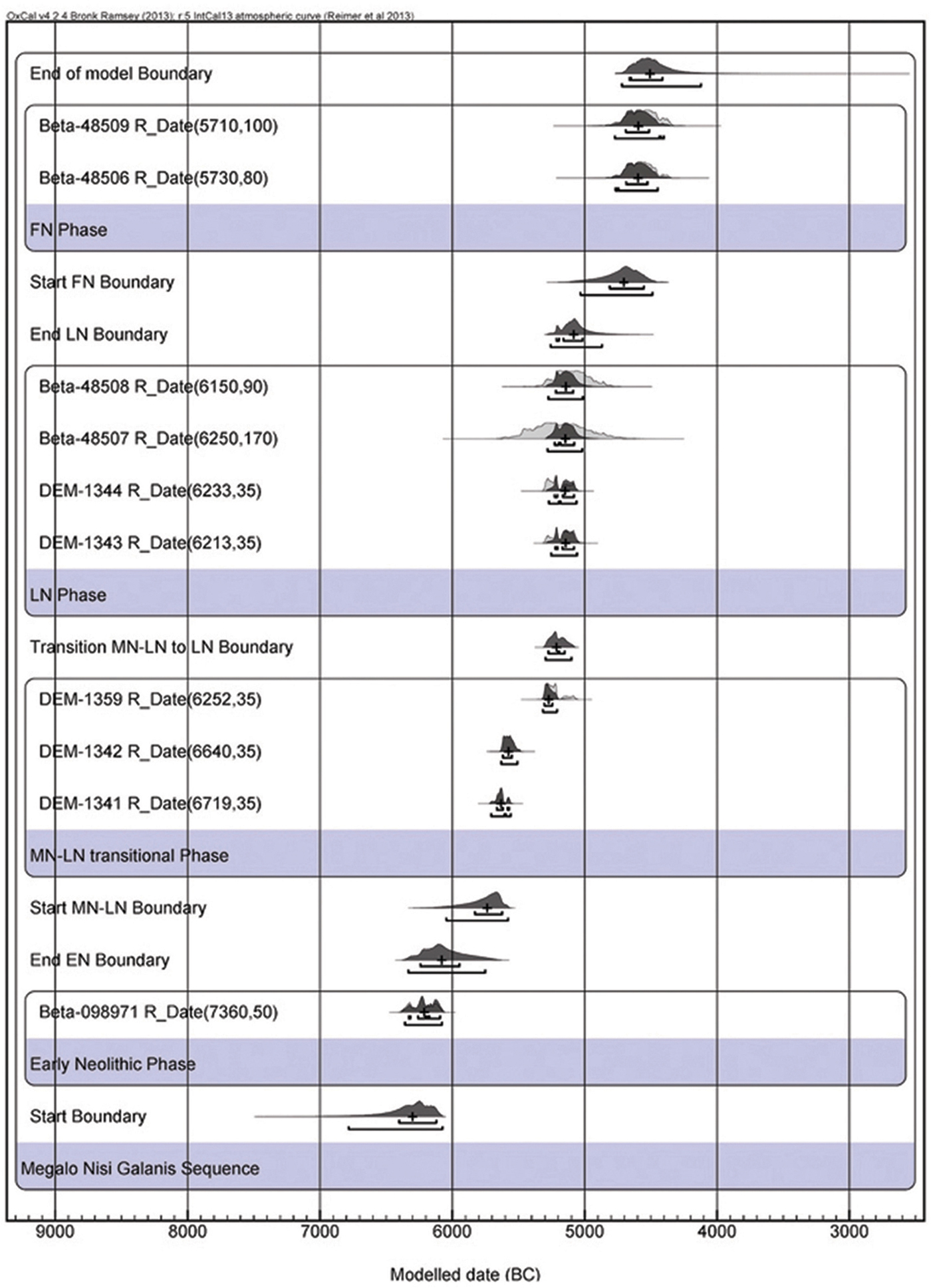
We undertook Bayesian modelling of the calibrated ages according to cultural phase and stratigraphic position, using the packages provided by the program OxCal (Bronk Ramsey Reference Bronk Ramsey2009a). We employed a four-phase model with the following phases: Early Neolithic (EN); a transitional phase from the Middle to the Late Neolithic (MN–LN); Late Neolithic (LN); and Final Neolithic (FN; see Table 1). A small part of the Middle Neolithic intervenes between the first and the second of those phases, but lacks radiocarbon dates and is accordingly ignored in the modelling.
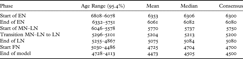
The EN phase is represented by a single sample (Beta-098971), the date of which is appreciably different, as expected, from the earliest sample in the MN–LN transitional phase. In order to accommodate this temporal distance (gap) in the model we used two boundary restrictions, one for the end of the EN and one for the start of the MN–LN phase. A temporal gap also obtains between the LN and the FN phases. For this we also used two boundary restrictions. The gaps in question do not necessarily represent site-wide occupational hiatuses; they rather result from the absence of samples suitable for dating. The model ran smoothly with all the samples converging to above 98.5 per cent. The output is shown in the multi-plot of Fig. 5. The numerical values for the beginning and end of each phase produced by the model are shown in Table 2.
MNG 14C calibrated ages modelled with Bayesian statistics using a four-phase model. See text for details.

MNG, results of the Bayesian analysis for the four-phase model. Dates in cal bc.

The start and end boundaries of the EN phase are not well defined, for the phase is represented by just one sample. However, we estimate that the EN phase should date somewhere between 6300 and 6000 bc. According to the model, the duration of the next phase, the MN–LN transition, was about 370 years (more precisely 366 ± 45 years), bracketed between the start boundary of this phase (5750 bc) and the transition boundary between the MN–LN and the LN phases (5200 bc; for remarks regarding the duration of the MN–LN and an estimate half as long, see SM Text 2). The LN phase starts without a break immediately after and ends around 5080 bc, spanning a rather short period of about 60 years (but that estimate is fraught with a large error margin: 71 ± 59 years). The shortness of the LN phase indicated by the model accords well with the diagnosis, made during excavation, that the upper part of the LN deposits was removed in the early Final Neolithic (see above, section ‘Description of the excavated deposits’ and SM Text 2). Last, our FN phase starts around 4700 bc, after an interval from the end of the LN phase of approximately 350 years, corresponding with the depositional hiatus in the area of the excavated trenches. According to the modelled chronology, intensive occupation at MNG continued until about 4500 bc or a little later. (Note that no 14C dates have been obtained from FN deposits higher up the sequence.)
Conclusions
Ten 14C dates from MNG, representing four chronostratigraphic units, were modelled with Bayesian statistics, and the duration of the corresponding cultural phases was determined according to the archaeological definitions and stratigraphy and the start and end dates for each phase. It is shown that the Neolithic occupation at MNG started about 6300 bc and went on until the second half of the fifth millennium bc. Subsequent occupation, extending to the Bronze Age, was limited and episodic, and is not radiocarbon-dated.
Both individually and as a sequence, the dates from the MNG Neolithic are in remarkably good agreement with currently proposed 14C chronologies for Thessaly and with the few dates available from west Macedonia (see Maniatis, Oberlin and Tsirtsoni Reference Maniatis, Oberlin, Tsirtsoni and Tsirtsoni2016; Reingruber et al. Reference Reingruber, Toufexis, Kyparissi-Apostolika, Anetakis, Maniatis and Facorellis2017; Maniatis Reference Maniatis, Stefani, Merousis and Dimoula2014). That is so in spite of the large error margin of several of the MNG dates and their patchy distribution.
The ceramic sequence
The goal of the ceramic analysis has been, on the one hand, to provide independent evidence for the cultural sequence at MNG and, on the other hand, to identify and interpret continuities and changes through time in the ways pots were produced and consumed. The analysis took into account four observable, measurable (or, at least, reconstructible) dimensions of pottery: pot shape, clay body, surface treatment, and pot capacity. Beside macroscopic examination of the excavated pottery, several analytical techniques were employed (see below).
The study was carried out in two periods: from 1989 to 1992 for material retrieved in 1987–9, and from 1995 to 1997, with a final season in 2000, for the pottery from the 1993 season. At the time, no study of comparable scope existed for Neolithic pottery from west Macedonia.
We summarise below the features of the principal Neolithic ceramic groups by cultural phase on the basis of the entire ceramic corpus from trenches M26, M27 and M36.Footnote 9 We conclude the section with a brief presentation of the ceramic evidence for the occupation of the site after the early Final Neolithic.
Middle Neolithic phase
Deposits assignable to the Middle Neolithic were reached only in trench M26, quarters β and δ, immediately above the natural sediments.Footnote 10 The main MN deposit is deposit 5A (Figs 2 and SM2:1). We have assigned the pottery it contains (about 500 sherds) to five groups: plain, red-slipped monochrome, decorated with birch bark tar, decorated with stripes, and barbotine. All these groups are also present in the next phase, the MN–LN transition, but pottery decorated with stripes disappears soon after the beginning of that phase.
Plain pottery
This group accounts for about half of the potsherds retrieved from deposit 5A. The principal shapes are shown in Fig. 6. A few cups and basins complete the collection. Attachments are rare, such as a small vertical handle, oval in section, which was detached from an open vessel with part of the wall.
MN and MN–LN transition, plain pottery. The stippling in (a) indicates birch bark tar on the wall next to the break. Drawings: R. Robertson.

Plain pots were coil-built. Irregularities on their walls indicate that potters did not always scrape them thoroughly during manufacture. Four potter's fingertip impressions are preserved on the break of a potsherd from a large basin that broke right at the coil join. An adhesive of organic provenance, probably birch bark tar (see below), was used for mending, e.g., on the ‘fruitstand’ rim shown in Fig. 6a. The adhesive covered the break, but it was also extended to both sides of the adjoining wall as a strip.
The clay body of plain bowls is fine-textured, micaceous to various degrees and slightly calcareous. It also contains very small grains of quartz and occasional grains of a dark coloured rock, possibly chert. Firing was not aimed at achieving standard colours, for the pots’ surfaces range from various shades of buff to almost black. Firing clouds are present as well. A few rims and bottoms from open shapes are grey throughout and lightly burnished. However, given the absence of complete pots or large parts of them, it is impossible to know if entirely grey pots, difficult to obtain in open or pit firings, were intentionally produced.
Red-slipped monochrome pottery
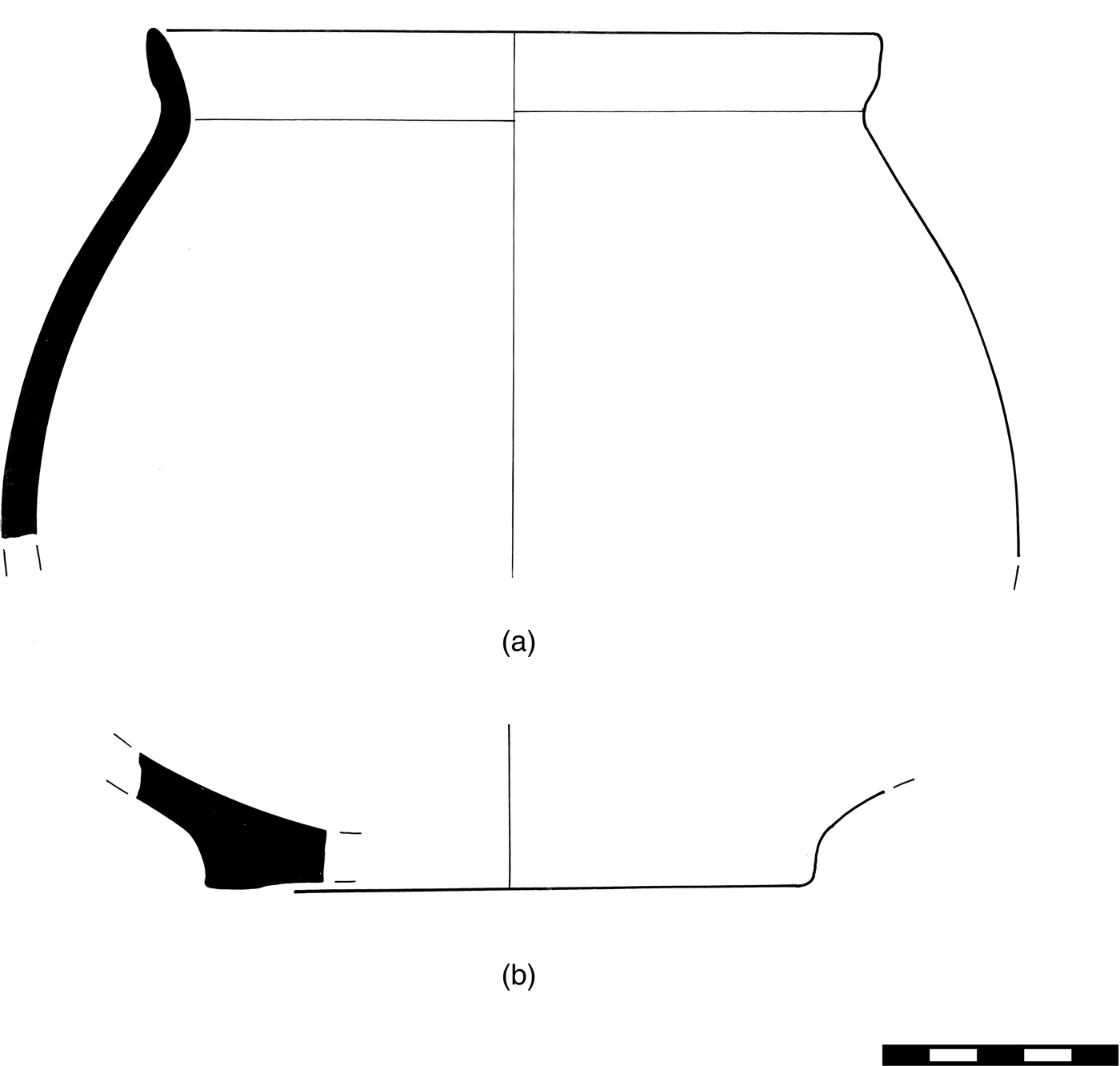
Red-slipped and plain pottery share similar shapes. The repertory of open shapes comprises small- and medium-size bowls with hemispherical or slightly flaring profiles as well as shallow, conical ‘fruitstands’ with rim diameters exceeding 25 cm. The few jars identified are of medium size with short, cylindrical or flaring necks with restricted opening (Fig. 7a). Bottoms are usually flat, but ring or discoidal bases also occur (Fig. 7b).
MN and MN–LN transition, red-slipped pottery. Drawing: R. Robertson.

The exterior of the pots is covered with a slip or paint rich in iron oxide. Fired in a predominantly oxidising atmosphere, the slip/paint turned to a bright red colour or shades thereof, including pink, and is clearly distinguished from the light brown/buff colour of the body underneath. The interior of bowls and jar necks is also slipped and fired to a red colour. The core, seen in the breaks, is in most cases grey, indicating incomplete oxidation during firing, probably in an open pit, and attainment of rather low temperatures. Some bowls were burnished, but in most cases the gloss is poorly preserved. Wear and scratches are visible on the underside of bottoms and the interior of bowls.
The clay body of bowls is slightly calcareous. It contains bits of shell, angular to sub-angular quartz grains up to 2 mm long and small mica flakes distributed evenly through the paste. Jars were probably made with a similar recipe but the texture of their clay body is coarser. Some organic materials (e.g. seeds) were left in the paste.
Red-slipped monochrome pottery represents up to 43 per cent of the total number of potsherds in deposit 5A. However, red-slipped monochrome continues to be present in variable, albeit decreasing, quantities up to deposit 17 (see Fig. 2).
Pottery decorated with birch bark tar
A few among the red-slipped pots have on their exterior patterns of dots, lines and narrow bands applied with a dark brown/black material unlike any mineral pigments encountered in Neolithic pottery (Fotiadis et al. Reference Fotiadis, Hondroyanni-Metoki, Kalogirou, Ziota, Hiller and Nikolov2000, fig. 5:2). Where this material has flaked off from the pot's surface, it has left a shiny mark. On one fragment from a necked jar, a series of dots combined with a white, fugitive pigment, of which only traces remain, mark the join of the neck with the shoulder.
A macroscopically comparable material has been preserved on the edges and breaks of potsherds, on broken bottoms and inside mending holes. Analysis of one sample by gas chromatography/mass spectroscopy indicated at the onset that the material had a botanical origin (Hutchinson et al. Reference Hutchinson, Kalogirou, Eberhard and Tabor1999). Chemical analysis by the same methods of three more samples produced at least one certain match with birch bark tar (Decavallas Reference Decavallas2011, 99–101, 211).
The evidence for the use of tars, especially birch bark tar, as a glue for mending pots, as a coating material and for decoration has grown considerably since the 1990s (see Urem-Kotsou et al. Reference Urem-Kotsou, Mitkidou, Dimitrakoudi, Kokkinos and Ntinou2018 and references therein). Refiring experiments of Neolithic sherds decorated with birch bark tar suggest that the material was applied after the pots’ initial firing, as otherwise it would burn off even at low temperatures (Yiouni Reference Yiouni2001, 20–1; Yiouni, Koukouli-Chrysanthaki and Ploumis Reference Yiouni, Koukouli-Chrysanthaki and Ploumis1994, 345). Finally, considering that birch trees were sparse in northern Greece during the Holocene and probably restricted to high altitudes, birch bark tar may have arrived at MNG as a finished product from afar (see Urem-Kotsou et al. Reference Urem-Kotsou, Mitkidou, Dimitrakoudi, Kokkinos and Ntinou2018, especially 74–5).
Pottery decorated with stripes
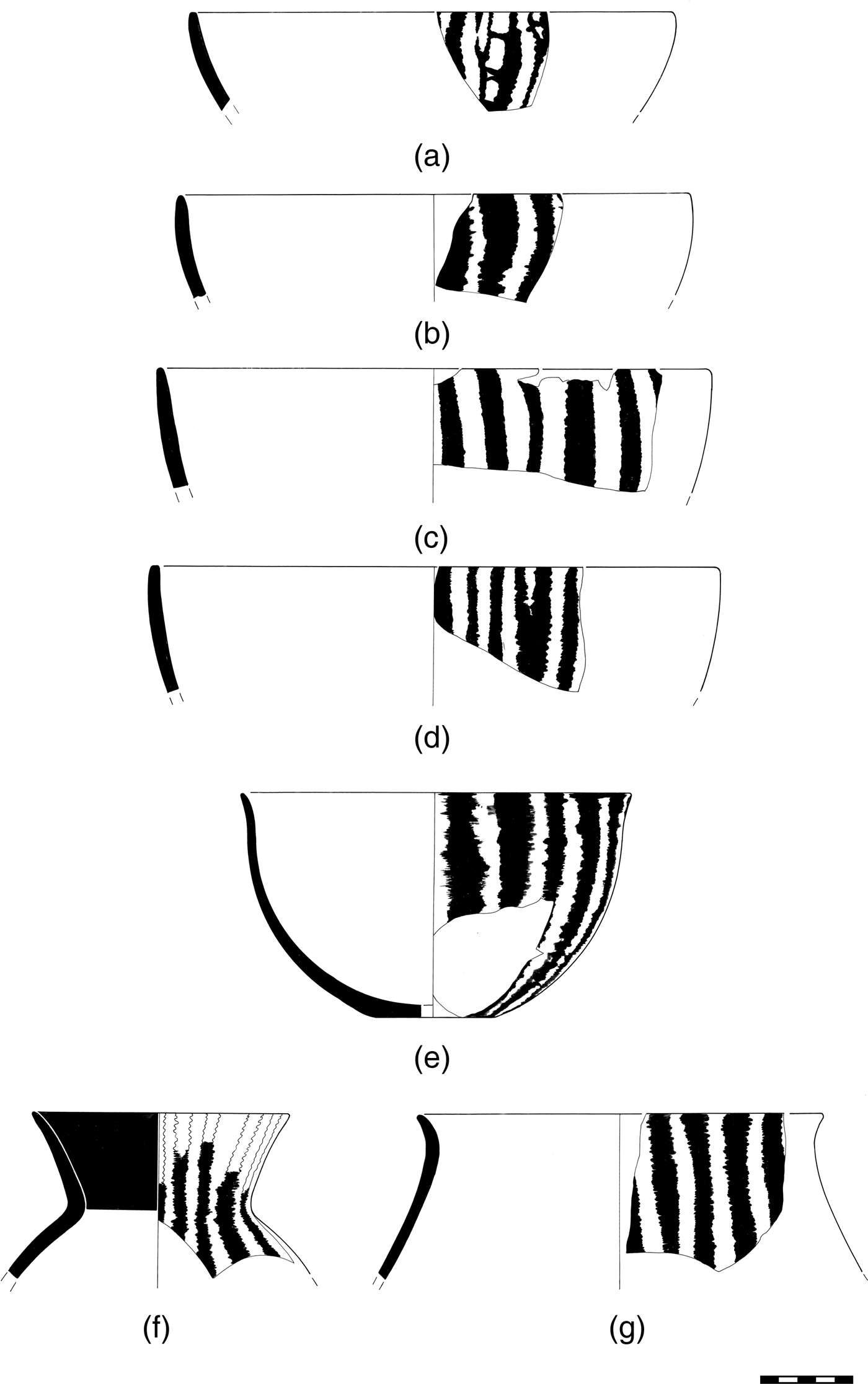
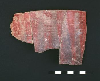
A number of bowls with rim diameters 22–31 cm, but also jars with flaring necks, have their exterior decorated with vertical or slightly oblique stripes with jagged edges (Fig. 8). Macroscopic examination suggests that the potters first covered the exterior of the pot with a red slip or paint; then, by scraping or wiping off parts of the slip, they created an effect of coloured stripes alternating with the exposed, ‘reserved’ surface of the pot underneath (Fig. 9). Subsequent smoothing of the stripes’ edges with a blunt tool, while the slip was still wet, gave them a blurred and wave-like appearance, called ‘moiré effect’ at Servia (Ridley and Wardle Reference Ridley and Wardle1979, 209). The interior of the pots as a rule is solid black, probably due to smudging at the end of the firing.
MN pottery decorated with stripes. Drawings: R. Robertson.

MN bowl decorated with stripes (colour online). Photo: G. Marinos.

The pots were probably burnished, but the gloss is poorly preserved. As in the case of the red-slipped pots, oxidising atmosphere prevailed during firing, for the decorative stripes have become red and pinkish, while the exposed body underneath in most cases acquired a light brown/buff colour. Firing clouds are present, however. Two rims from shallow bowls are exceptional because the stripes are cream or very light pink-coloured (Fig. SM3:2).
The striped pots from MNG are confined to deposit 5A and the lowest part of deposit 5B. They strongly recall the so-called ‘scraped ware’ (‘ξεστή’ in Greek) amply documented in Thessaly but less common north of the Aliakmon valley.
Barbotine pottery
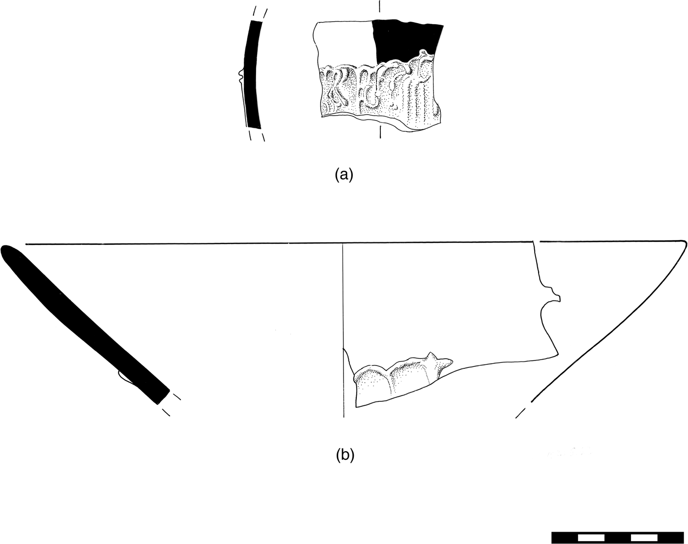
Already present in the lowest anthropogenic deposit of trench M26 (deposit 5A), barbotine pottery is also found, along with red-slipped and plain pottery, throughout the deposits we have assigned to the MN–LN transition. Its frequency in passes belonging to those deposits is low, usually less than 10 per cent (Fig. SM2:2). It is absent from later deposits, except for the occasional ‘kick-up’.
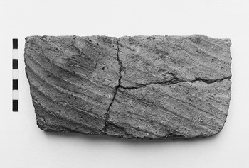
Barbotine pottery is a familiar occurrence in northern Greek and Balkan Neolithic sites. Its distinguishing feature is the textured, sometimes furrowed, exterior surface (Fig. 10), created by applying a layer of clay slurry of variable thickness (Rice Reference Rice1987, 149: ‘slip trailing’ or ‘barbotine’) after the pot was formed, scraped and smoothed, but before it was fired. Barbotine did not extend up to the pot's rim.Footnote 11 Macroscopic examination indicates that the barbotine layer and the clay used for building the pot were similar in composition. Barbotine pottery was low-fired with frequent firing clouds on the exterior surface.
MN–LN transition, basin fragment with barbotine furrows. Photo: G. Marinos.

The MNG barbotine sample comprises 138 sherds from large, thick-walled basins and only a few jars. Because of the fragmentary condition of the material, it has not been possible to reconstruct complete profiles. On 18 sherds from both thick-walled basins and smaller pots with thinner walls, the clay slurry forms a pattern of consecutive arcs with raised edges (Fig. 11).Footnote 12 A unique case is the potsherd illustrated in Fig. 11a, where barbotine treatment is combined with red paint (black in the drawing).
MN and MN–LN transition, barbotine pottery. Drawings: R. Robertson.

Barbotine work should have facilitated the handling of large, heavy vessels such as those excavated at MNG. Further exploration of use-related questions regarding barbotine pottery would be rewarding.
Recycled potsherds
Pots broke and were discarded, but some fragments acquired a second life. In the MN deposits of MNG, small ceramic discs made by chipping and rubbing potsherds around their circumference were retrieved from several passes (Fig. SM3:3; see also Ridley, Wardle and Mould Reference Ridley, Wardle and Mould2000, 207–14). Some of the discs are perforated.
Middle–Late Neolithic transitional phase
The appearance of black burnished pottery in a Neolithic stratigraphic sequence has long been thought to signal the beginning of the LN phase. Some scholars, however, acknowledge that black burnished pottery did not at once replace the kinds of pottery used in the Middle Neolithic and that typical MN ceramics coexisted for some time with the new pottery. We have estimated that at MNG the period of coexistence lasted between 100 and 200 years; moreover, the replacement of the old by the new ceramic traditions proceeded in a gradual fashion (SM Text 2 and Fig. SM2:2). We decided to acknowledge straightforwardly that situation and name the period of coexistence ‘Middle–Late Neolithic transitional phase’ (for short, ‘MN–LN transition’).
The MN–LN transition at MNG is dated by three 14C dates somewhere between 5750 and 5200 bc (see section ‘Radiocarbon dating’ and SM Text 2). The MN ceramic groups discussed above coexist with black burnished pottery in the relevant deposits, except for pots decorated with stripes, which disappear in deposits above 5B. The changing frequencies of red-slipped, barbotine and black burnished pots are shown in Fig. SM2:2 (passes δ.65 to δ.45, corresponding to deposits 5B to 17).
Black burnished pottery
‘Black burnished’ refers to only one feature of this group, namely the shiny black colour of the pots’ exteriors. We use the term for convenience, while keeping in mind that black burnished pottery occurs in later phases of the Greek Neolithic as well.
The commonest shapes at MNG are, in decreasing order of frequency, bowls, shallow basins and collared jars. Bowls are of small to medium size with rim diameters between 12 and 18 cm (Fig. 12). Some bowls have a low collar and a carinated rather than fully rounded profile. Bowls were thoroughly scraped until the walls acquired a uniform thickness (3.5–5 mm near the rim). Appendages are rare. The identification of bottom fragments is problematic, mainly because of the near-imperceptible angle between the walls and the pots’ bases. Attempts at repair are indicated by drilled holes. Bowls could be meticulously decorated (see below).
MN–LN transition, black burnished bowls with relief decoration. Drawings: R. Robertson.

Basins (diameter larger than 25 cm) were shallow containers with convex walls ending in a flattened lip. No appendages could be associated with them. At least one example was burnished in a streaky fashion and was fired to a dark grey colour instead of jet-black. Unlike bowls, basins were not decorated, except possibly by applications of barbotine.
The sample of collared jars is small and fragmentary. The few rim diameters that could be estimated with confidence range from 18 to 36 cm. Wall thickness at the shoulder is 7–12 mm. The collars, as tall as 10 cm, have slightly flaring or, more rarely, cylindrical walls. The join with the shoulder is marked with a groove. Some jars have a carinated profile, but the carination is not as pronounced as in the LN black topped assemblage (discussed below). The few appendages include oval-shaped protrusions, triangular lugs placed on the carination and a small, angular handle placed vertically on the collar. The exterior was burnished, but not always to a high gloss. Most interiors are dark grey, as are cores.
The clay body of bowls is fine-textured, is slightly calcareous, and contains microscopic, evenly distributed bits of quartz and some mica. That of jars is somewhat coarser, with occasional quartz fragments up to 5 mm long and, at times, hairline-cracks emanating from larger grains of aplastics left in the clay body. Perhaps, the clay body was adjusted according to the type of vessel to be made.
Black burnished bowls are decorated on their exterior with linear patterns in low relief. The patterns comprise sets of two to five parallel lines that run downward from the rim in a crisscross fashion. They are often combined with a row of tiny relief pellets placed near the rim (Fig. 12b). This type of decoration, also known from LN Servia, was named ‘ribbing’ by Heurtley (Reference Heurtley1939, 69). The potters created the patterns with narrow strips and small pellets of clay and, then, burnished them over. Collared jars bear no decoration, except for one example with barely visible oblique ‘ribbing’ on the shoulder.
Vitelli (Reference Vitelli1999, 26–7) has extensively discussed the colours and firing techniques related to black burnished pottery. Macroscopic examination of the MNG material suggests firing in reducing conditions; smudging is another possibility.
Late Neolithic phase
The Late Neolithic deposits in their upper part are truncated. Still, the preserved part is almost one metre thick. It covers a period of 60 to 120 years, radiocarbon-dated between 5200 and 5080 bc (see section ‘Radiocarbon dating’ and SM Text 2). Stratified LN material was excavated in trenches Μ26, Μ27 and Μ36.
The principal phase marker is black topped pottery. Black burnished pottery coexists with black topped in the lowest few centimetres of the relevant deposits, but disappears higher up.
Black topped pottery
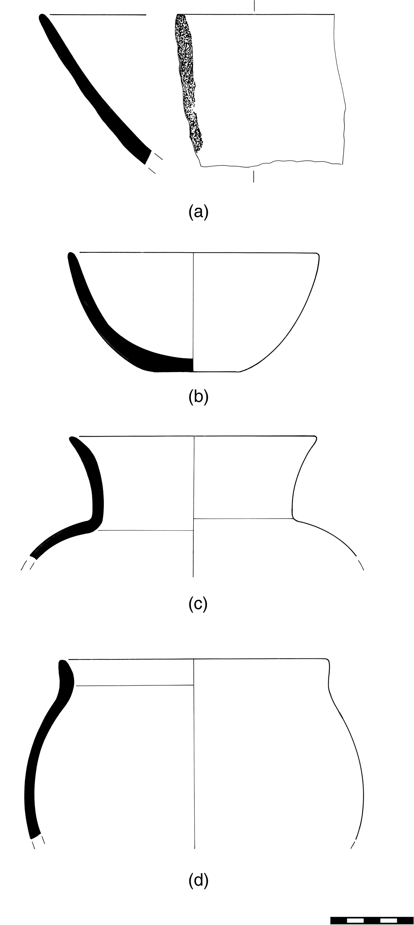
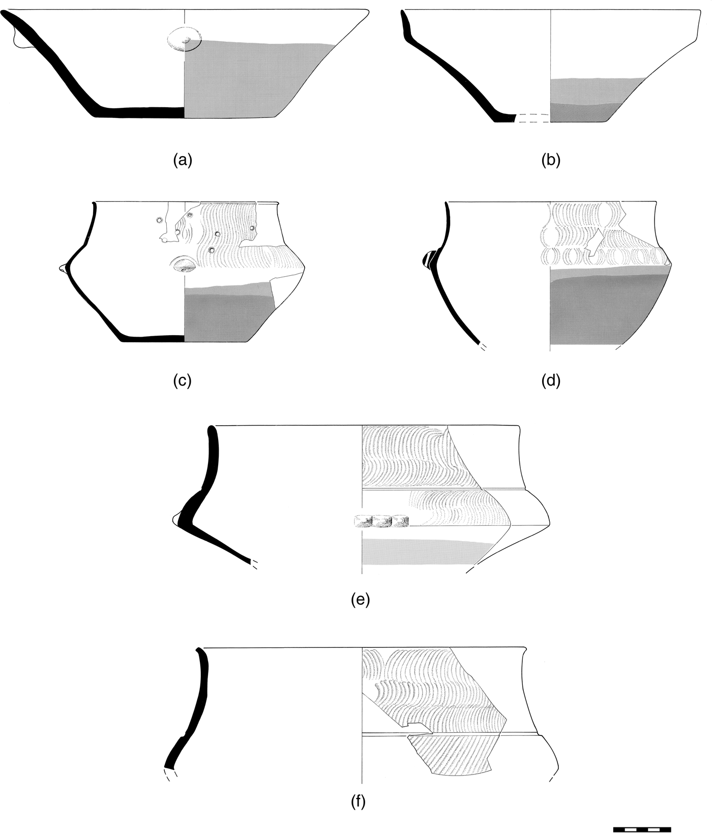
Black topped pots are black in the upper part of their exterior, while the lower part is uniformly light brown or bichrome, with an orange zone below the brown part. The interior is dark grey, less frequently brown or black. Marking of the interior rim by more intense burnishing is common in all shapes. The principal pot shapes are conical bowls, conical basins (diameters exceeding 30 cm), carinated bowls, carinated collared bowls and carinated collared jars.
Conical bowls and basins resemble a truncated cone in section. They have a straight or gently flaring rim (Fig. 13a). Wall thickness near the rim is 5–8 mm, sometimes less. Appendages include conical protrusions and horizontal lugs, oval, quadrangular or conical. They are placed below the rim and can be vertically perforated. A couple of specimens bear painted patterns on the lower part (see Kalogirou Reference Kalogirou, Laffineur and Betancourt1997, pl. Ia), while a single rim fragment from a conical bowl is pattern-painted on the interior.
LN, black topped pottery: (a) conical bowl, (b) carinated bowl, (c)–(f) carinated collared bowls and jars with rippled decoration. Drawings: R. Robertson.

Carinated bowls are fairly shallow containers with diameters 11–28 cm (Fig. 13b). Their walls are thinner than those of basins. Appendages include vertically perforated small lugs and protrusions placed just above the carination.
Carinated collared bowls are small- to medium-size pots with an added collar terminating in a gently flaring rim (Fig. 13c and d). Rim diameters range from 14 to 25 cm. The collar begins at about the point of maximum diameter and its join to the shoulder is marked with a narrow, shallow groove. Attachments include rounded, conical and elongated lugs at or near the carination, sometimes combined with small protrusions or incisions. When these fragile, thin-walled pots broke, their users attempted to mend them, as shown by sets of holes drilled in the walls (Fig. 13c).
Carinated collared jars are medium- to large-size vessels with an added collar more than 5 cm tall beginning above the point of maximum diameter (Fig. 13e and f). The diameter at the tip of the rim, which is slightly flaring, ranges from 22 to 47 cm. The height of these vessels has been estimated to as much as 50 cm. The join of the collar to the shoulder is marked with a narrow, shallow groove, as in the case of collared bowls. Appendages include small protrusions on the carination, single, in pairs or sets of three, as well as elongated or crescent-shaped lugs (Fig. 13e).
Black topped pots have flat or slightly concave bottoms with diameters between 7.5 and 18 cm. The thickness of the bottoms of open shapes is no more than 8 mm. In a unique case, the underside of the bottom of a bowl is pattern-burnished (Fig. SM3:4). Unique also is a small bowl with an elliptical opening (largest diameter is about 15 cm). The rim is completely flat, thickens abruptly toward the interior and bears two vertical perforations. On its exterior the bowl has a vertical groove, perhaps for securing in place a twine or string.
The clay body of black topped pots is fine-textured and slightly micaceous. Petrographic analysis of 11 samples confirmed, first, that black topped pots were made from non-calcareous clays and, second, that the clay body contained quartz, feldspar, muscovite mica and iron, in addition to some organic matter (Kalogirou Reference Kalogirou1994, 181–97).
Carinated collared bowls and jars were decorated with patterns in low relief, extending over the black part of the pot above the carination. The patterns were created with a burnishing tool while the pot was still wet. This kind of decoration produced a fine ‘rippling’, better noticed in raking light or by stroking the surface with the fingertips. The rippling consists of parallel lines, arcs and opposing chevrons in alternating directions, and combinations of the above (Fig. 13c–f). On collared jars, rippling was also combined with concentric arcs near the carination. Less frequently, rippling was combined with small depressions above the carination executed with a blunt tool. The black topped pots from MNG with ‘rippled’ decoration are among the finest examples we know.
The bichrome or trichrome exterior and the dark interior of the pots were the result of the firing procedure.Footnote 13 In general, the potters were in good command of the procedure. No misfired pieces were noticed, for instance, among the collared bowls decorated with rippling. Nevertheless, firing accidents did occur: one rim fired to an orange colour instead of black; a second example has a mottled, black and light brown exterior; a third example shows a light brown ‘oxidation spot’ on the black zone. Finally, the rim of a collared jar has fired black except for a narrow zone that is almost white.
Several observations lead us to propose that black topped pots developed from black burnished through modifications of the older recipe over time. In brief, open shapes predominate in both potteries, while substantial appendages are rare. Shapes with collars are common in both groups and have a groove marking the join with the collar. Carinated profiles first appeared in black burnished pots, although they are far more pronounced in black topped pottery. Surface treatment also is comparable, including the decoration in low relief even though the execution is different. Furthermore, in both cases, the final colour of the pots was obtained not with the use of paints and slips but through controlled firing. Last, relevant to our proposal is the observation that black burnished and black topped pottery coexisted for a short while at the beginning of the Late Neolithic (see above).
Plain pottery
Not all pottery in the LN deposits is black topped. Plain, undecorated pottery with entirely different characteristics is also present. Hole-mouth jars are among the plain pottery shapes, gently carinated or squashed, with one or more lugs attached to the lower part of their body. Their median capacity is about five litres. Their surfaces are scraped, smoothed, slipped and lightly polished on the exterior, with firing clouds. The clay body is non-calcareous and contains numerous sizable aplastics, identified by petrographic analysis as schist, serpentine and talc (Kalogirou Reference Kalogirou1994, 188–97). The interior surfaces of some specimens bear vertical and oblique scratches together with heavy pitting, presumably from use. No traces of soot or highly oxidised areas were found on these pots, so it seems that they were not used as cooking pots.
‘Plates’ is the conventional name given to shallow, open vessels with diameters 34–45 cm or larger with a convex bottom. Plates (‘plateaux’ in the French bibliography, “ταψιά” or “δίσκοι” in Greek) were most likely formed and finished either inside a depression dug in the ground or in a concave mould, as suggested by their form, size, rough exterior, half-finished rim exteriors and decreasing wall thickness from rim to bottom. At MNG the interior was scraped, smoothed and in some examples also lightly polished. No intact plates were excavated nor could profiles be extensively reconstructed. Plates were made from at least three different clay bodies, named after their salient ingredients, ‘sand’, ‘schist’ and ‘mica’ pastes. Plates were produced in small numbers. The frequency of their fragments never exceeds 10 per cent in the LN deposits, and is usually much less.
Plates were evidently special-purpose utensils, perhaps permanent fixtures of LN houses, placed near ovens and used in the preparation of food (Tsirtsoni Reference Tsirtsoni2000, pl. 4; Treuil and Tsirtsoni Reference Treuil, Tsirtsoni, Hiller and Nikolov2000, 214; Urem-Kotsou Reference Urem-Kotsou2006, fig. 7:1). Organic residue analysis was attempted on four samples from MNG, but the sherds produced no relevant evidence (Decavallas Reference Decavallas2011).
Final Neolithic (early)
‘Final Neolithic’ is a catch-all name for the time period between the middle of the fifth millennium bc and the Early Bronze Age in Greece, about 1500 years later. The bulk of the FN material from MNG belongs to the first several hundred years of that long period, and it is discussed here. Ceramics from the remaining part of the FN phase are briefly discussed in the next section. Stratified deposits of the Final Neolithic were excavated in trenches Μ26, Μ27 and Μ36. Their integrity had been compromised by ploughing down to about 50 cm below the modern surface. That left 50–70 cm of FN deposits in a pristine state (deposits 45 and 48 in Fig. 2). A temporal hiatus of up to 350 years obtains between the LN and FN deposits in the excavated trenches. Other parts of the site, beyond the excavated trenches, were most probably inhabited during that 350-year interval.
The pottery from deposits 45, 48 and 50 (more than half a metric ton) exhibits an impressive variety of shapes, surface treatments and clay bodies, and is radically different from what preceded it. Final Neolithic pots have true handles, in addition to lugs and other kinds of attachments and appendages. Flat bottoms are the rule, but bowls with pedestals and added bases or feet also occur. With regard to raw materials, the most important difference from the earlier phases is the use of calcareous clays, in addition to non-calcareous ones. The much greater variety of clay bodies implies the concurrent use of several recipes for making pots. That variety is paralleled by the greater variety and, perhaps, quantity of containers and other utensils and facilities made of clay.
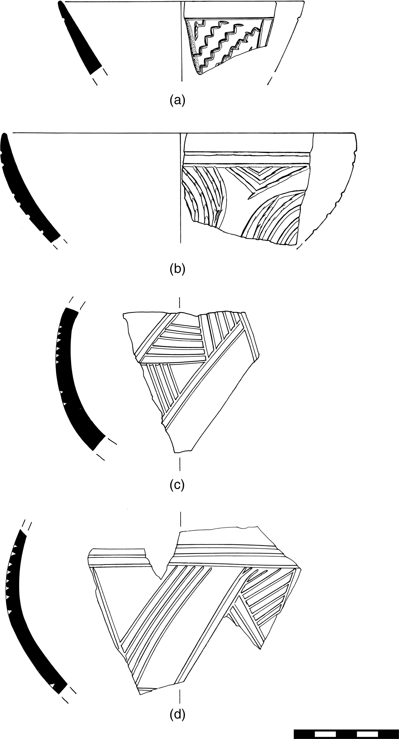
Hemispherical bowls of various profiles and sizes predominate. Bowls were scraped, smoothed and often slipped and burnished. Some small bowls bear incised patterns (Fig. 14); others are painted with two or even three different slips. Large basins and jars, necked and hole-mouth, account for at least one third of the pottery. The increase in the frequency of large, expediently made jars is notable. Some of them may have exceeded 60 cm in height.
FN (early), pottery with incised patterns. Drawings: R. Robertson.

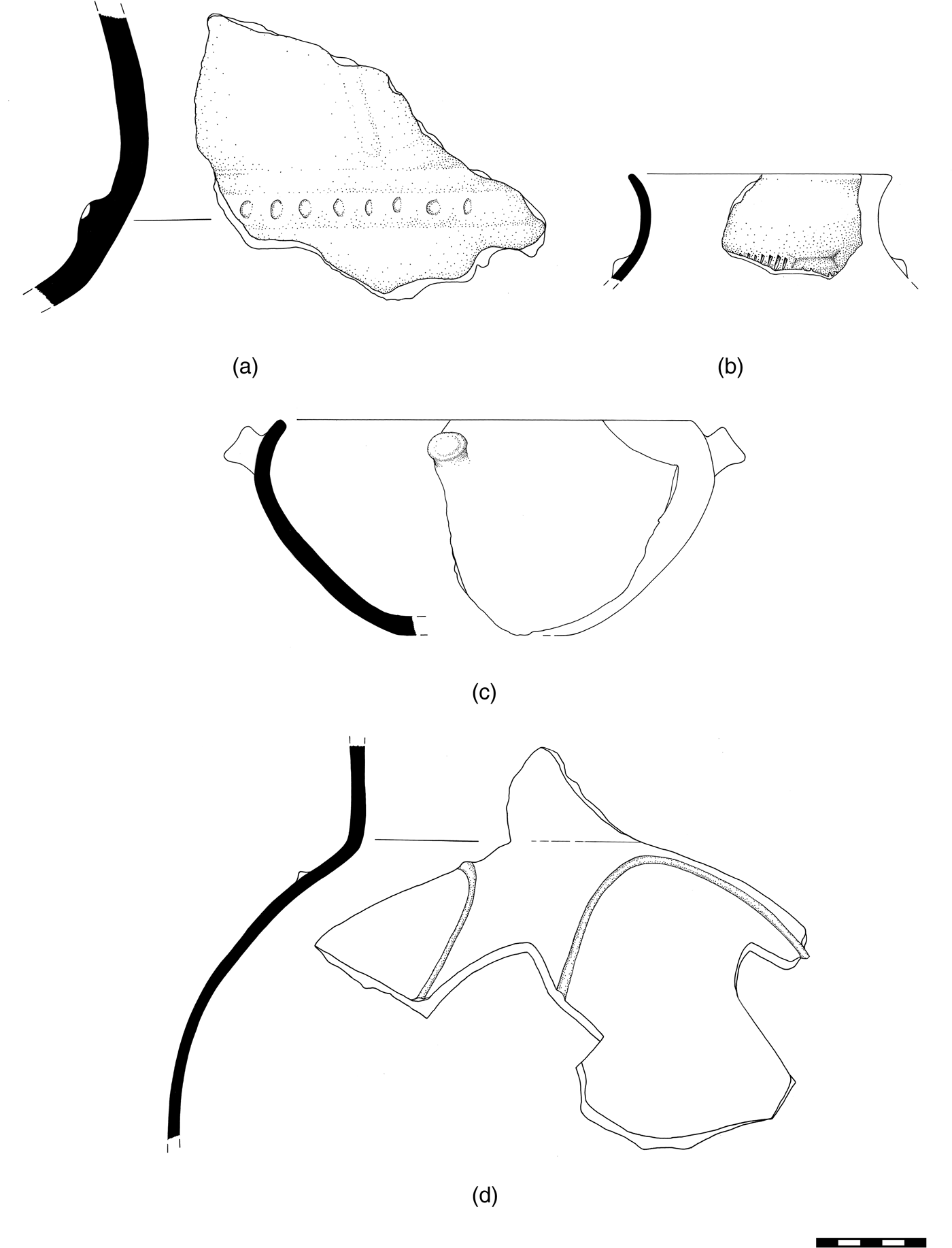
A small group of pots is worth singling out because of its idiosyncratic features. Reconstructions based on sizeable potsherds indicate that the typical shape is a bowl with a complex, bulging profile. Such bowls have rim diameters 10–30 cm, flat bottoms, walls of even thickness around the circumference and at least one vertically perforated lug at the point of maximum diameter. Their upper part has wide, shallow grooves executed with a blunt tool, while the lower part bears painted patterns (Fig. 15a–c).Footnote 14 The grooved patterns consist of concentric arcs, probably repeated around the pot's circumference. The grooves were filled with a fine-grained, fugitive cream-coloured or light brown pigment. The same pigment was used to paint the linear patterns of the lower part. The bowls are burnished on both the exterior and the interior and are fired to dark grey, brown and black colours. Two different clay bodies have been petrographically distinguished. These pots were produced in small numbers in the early Final Neolithic and were in circulation only for a short time.
FN (early): (a)–(c) bowls with bulging upper body; (d)–(g) perforated utensils. Drawings: (a) and (b) J. Sauser; (c)–(e) R. Robertson; (f) L. Talalay; (g) L. Talalay and T. Vakouftsi.

Utensils with perforations, often called ‘strainers’, ‘sieves’ or ‘cheese-pots’, are also present in small numbers (Figs 15d–g and SM3:5; note that the utensil in Fig. 15e is open at both ends). Organic residue analysis of three sherds identified in two of them fats of animal origin, thereby indicating a possible connection with cheese production, but uses related to meat processing could not be excluded (Decavallas Reference Decavallas2011, 212–15). Perforated utensils probably served a variety of purposes (Kalogirou Reference Kalogirou1994, 154–61).
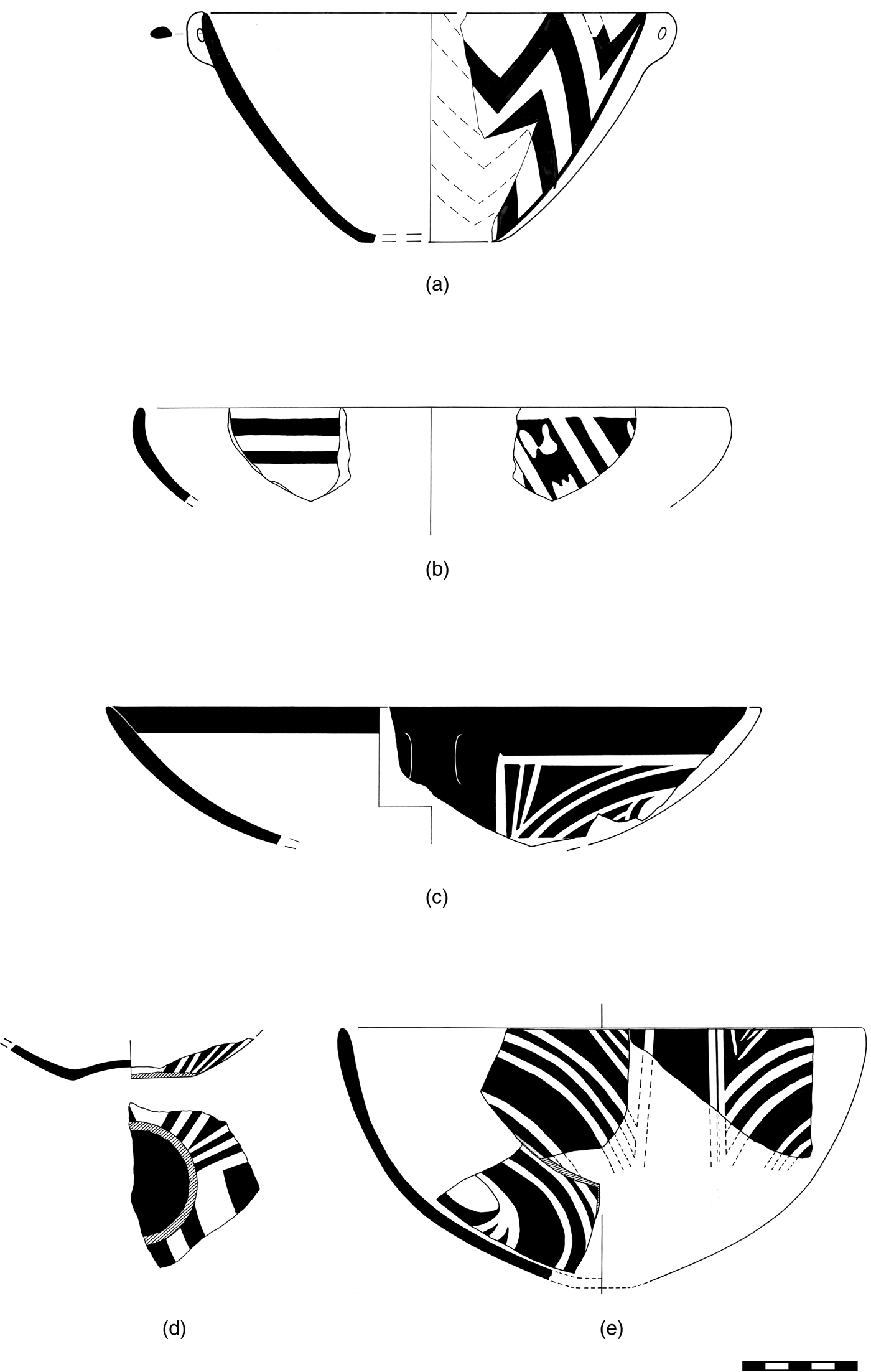
Pattern-painted decoration is not common in early FN pottery. It is mostly found on medium-size bowls. The cream-on-red variation occurs more frequently than the inverse (Figs 16 and SM3:6). A handful of potsherds with distinctive ‘classical Dimini’ patterns (e.g., checkerboard and spirals) may represent imports, as may one sherd with distinctive east-Macedonian black-on-red patterns.
FN (early), pattern-painted bowls: (a) red-on-white, (b)–(e) cream-on-red. Drawings: R. Robertson.

‘Crusted’ pottery is another feature of the early FN phase. At MNG ‘crusts’, defined as thick coatings of pigment/slip applied on the finished exterior and/or interior of a pot usually after firing, are either white or bright coloured, e.g., red, pink or orange. ‘Crusts’ could have been applied at any point during a pot's life. They formed linear and solid patterns on the surface of plain pots, but they were also used on pedestals and to fill incisions. Two different ‘crusts’, white and red, are combined in some pots (Figs SM3:7 and SM3:8).
Thirteen FN decorated potsherds from MNG were analysed by two non-destructive methods, X-ray fluorescence (XRF) and near infrared spectroscopy (NIRS), in order to identify the chemical composition of the paints (most probably applied before the pots’ firing) and ‘crusts’ (assumed to be a post-firing application). Hematite proved to be a critical ingredient of the red crusts, while talc, serpentine and saponite were ingredients of the light-coloured and white crusts. The analysis confirmed that ‘crusts’, as defined above, were, as a rule, applied after the pot's initial firing (Aloupi Reference Aloupi2003).
The FN inventory also includes ‘scoops’, miniature and asymmetrical pots, as well as angular or quadrangular (box-like) containers (Fig. SM3:9). Last, in almost every FN excavation unit we recorded the presence of potsherds that had been recycled, e.g., as small containers, covers/lids or tools for rubbing and scraping.
Final Neolithic (advanced) – Bronze Age
The plough zone in the area of the M trenches (deposit no. 50 in Fig. 2) contains pottery primarily from the early Final Neolithic, but also material from advanced stages of the Final Neolithic and from the Bronze Age. A small portion of that material can be dated to the fourth millennium bc, especially to its second half. Examples include a cup fragment with Baden-pottery affinities.Footnote 15 Included also are a handful of ‘rolled’ (‘Kumtepe 1b’-type) rims from bowls datable to around 3000 bc (see also Fotiadis and Hondroyanni-Metoki Reference Fotiadis and Hondroyanni-Metoki1993, fig. 4α–δ, from the ‘dump’).
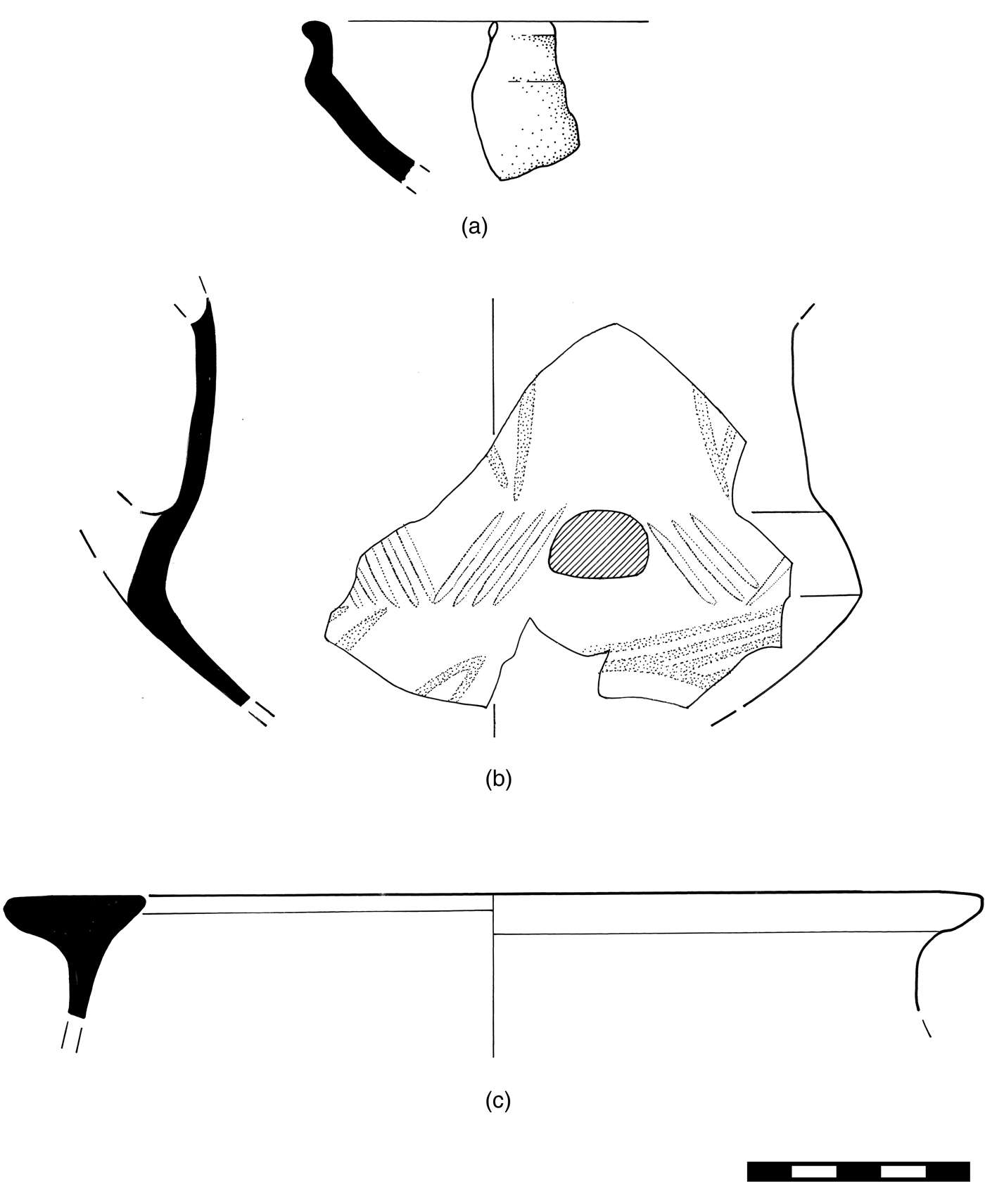
Coarse, thick-walled jars with ledge or coil-built sturdy handles, pithoi and jugs with strap handles are common in the plough zone. They include fragments from necked jars with applied strips at the join of the neck with the shoulder, decorated by pinching or with finger-tip impressions (Fig. 17a; see also Kalogirou Reference Kalogirou1994, 130 and fig. 54a). Such pieces date to the advanced Final Neolithic or to the beginning of the Early Bronze Age (cf. Adrymi-Sismani Reference Adrymi-Sismani and Tsirtsoni2016, fig. 6b; Grammenos Reference Grammenos1981, fig. 6; Hanschmann and Milojčić Reference Hanschmann and Milojčić1976, pl. 39; Toufexis Reference Toufexis and Tsirtsoni2016, fig. 13).
FN (advanced) – EBA pottery from deposit 50 (plough zone). Drawings: A. Akın.

Pottery from later EBA phases is more abundant. Examples include a large fragment from a coarse globular jar with ‘corded’ decoration (four parallel vertical impressions from a twisted cord; cf. Sherratt Reference Sherratt, Renfrew, Gimbutas and Elster1986, fig. 13.13:6 and 7); the rim and neck from a small jar with an angular protrusion and wedge-shaped incisions (Fig. 17b; cf. Grammenos Reference Grammenos1981, figs 17, 18 and 21 for the pot's shape); and a large bowl, black on the exterior, with incurving rim and a cylindrical protrusion (Fig. 17c; cf. Hanschmann and Milojčić Reference Hanschmann and Milojčić1976, foldout 17:2). The sample also includes twisted and split handles (cf. Hanschmann and Milojčić Reference Hanschmann and Milojčić1976, pl. 26:6 and 7; Heurtley Reference Heurtley1939, fig. 61a and b).
A fragment from a large necked jar with applied strips forming a curvilinear pattern (Fig. 17d) most likely dates near the end of the Early Bronze Age (cf. Hanschmann and Milojčić Reference Hanschmann and Milojčić1976, pl. 80:6; Heurtley Reference Heurtley1939, fig. 51). Remarkable also, and probably of similar age, is a jar fragment with a large horizontal handle ending in four ridges that resemble human fingers.Footnote 16
The three potsherds of Fig. 18, from a small pit in trench M36, represent the most recent ceramic material from MNG, dating to the end of the Early or even the beginning of the Middle Bronze Age. That is indicated by the S-shaped profile of the rim from a black burnished bowl (Fig. 18a; cf. Hanschmann and Milojčić Reference Hanschmann and Milojčić1976, foldout 21:14), the carinated pot with two (?) handles (Fig. 18b; cf. Ziota Reference Ziota2007, fig. 3:1) and the T-shaped rim from a large jar (Fig. 18c; cf. Hanschmann Reference Hanschmann1981, pls 81 and VII:4).
End EBA – beginning Middle Bronze Age pottery from deposit 50 (plough zone). Drawings: (a) A. Akın; (b) and (c) R. Robertson.

Flaked stone
Kitrini Limni and its neighbouring mountains and basins in all directions, including the Aliakmon valley c.20 kilometres to the south, are poor in siliceous rocks suitable for flaked stone tools. Milk-white quartz is found in Mount Vermio, at several hours hike from Kitrini Limni. Sizable chunks of it, extracted directly from veins, were brought to MNG where they were reduced to shards with sharp edges. The reduction appears to have been achieved by simple techniques, involving none of the sophistication of prismatic core technology. Few, if any, of the products could have served as inserts in composite tools. Some may have been used as intermediate tools (e.g., wedges) for working materials such as wood, bone and antler (see de la Peña Reference Peña2015). In general, the contribution of quartz to the technology of MNG is unclear, and was probably limited to a few tasks.
The majority of flaked stone tools from MNG were made from siliceous rocks of superior quality, absent from the region, and by techniques requiring far greater technical knowledge and skills than the reduction of quartz. The commonest raw materials are radiolarites (available in the mountain ranges of the west Balkans, including Pindos; see, e.g., Chiari et al. Reference Chiari, Bortolotti, Marcucci, Photiadis, Principi and Saccani2012), a grey flint (also present in Pindos) and a yellow flint, much like what is often referred to as ‘honey flint’, which probably originated in west Epirus or south Albania (see Perlès Reference Perlès1992, 124 and fig. 1; cf. Runnels et al. Reference Runnels, Korkuti, Galaty, Timpson, Whitaker, Stocker, Davis, Bejko and Muçaj2004, 13). Obsidian macroscopically identifiable as Melian also is present in small amounts through part of the sequence, its frequency being noticeably higher in the FN deposits.Footnote 17 Delicate obsidian blades were removed from pyramidal cores by pressure flaking. Pressure-flaked too were several long, broad blades from high-quality varieties of chert.
Several observations in combination have led us to the following scenario. The flakes and blades from fine siliceous stones we found at MNG were produced by expert craftspeople who were familiar with the geography of the raw material sources and could access them within a few days from their habitation sites. Direct procurement by the Kitrini Limni folks is unlikely given the distance to the sources (between one and several hundred kilometres). Flaked stone pieces reached MNG in advanced stages of workmanship (rarely as cores), brought to Kitrini Limni by intermediaries or, as in the case of obsidian, by the expert craftsmen themselves, peddling the products of their expertise from one site to the next (see Perlès, e.g., Reference Perlès1992, 128, 136–7). Once acquired by the inhabitants of MNG, the pieces were frequently modified, recycled and put to new uses.
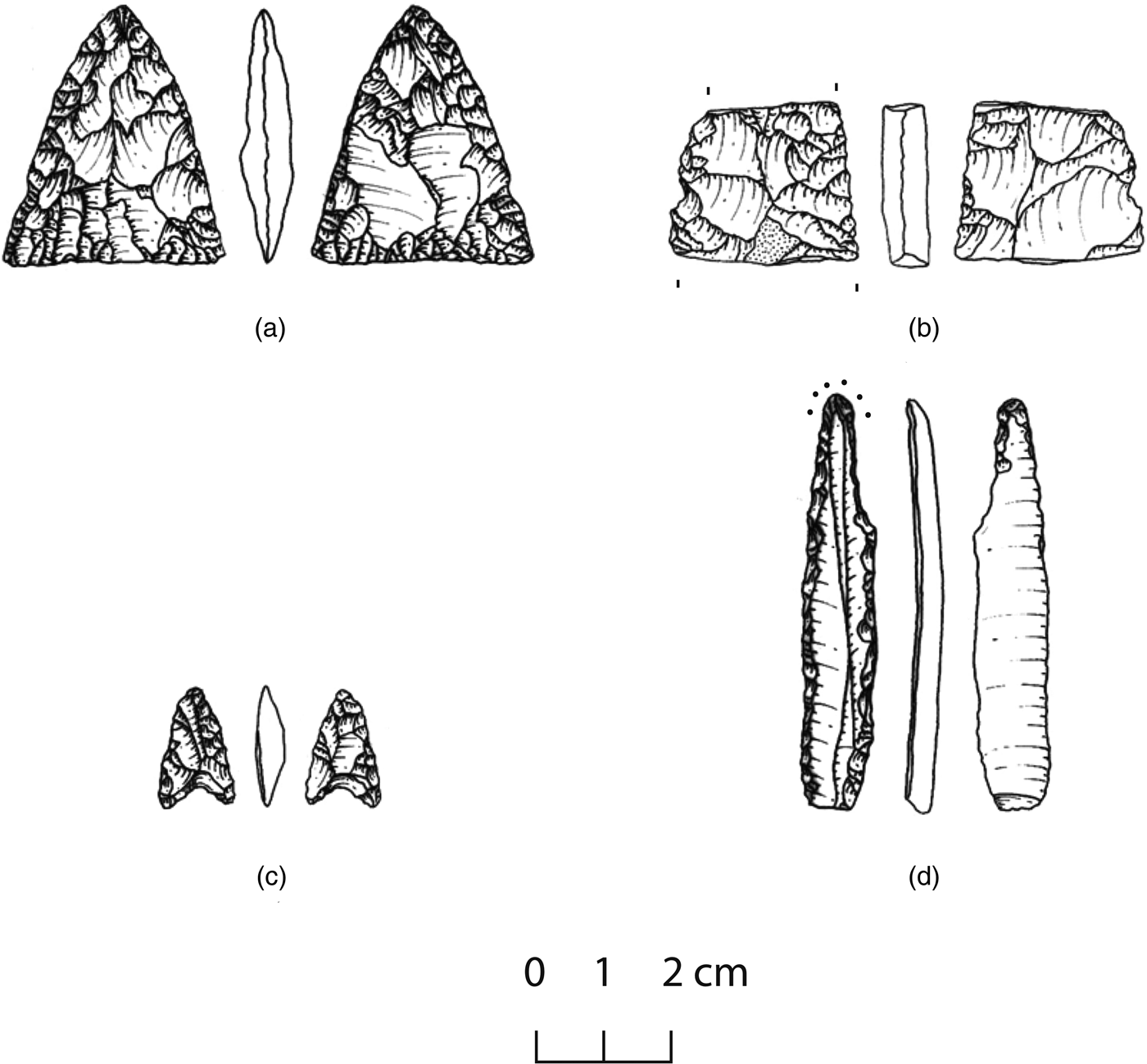
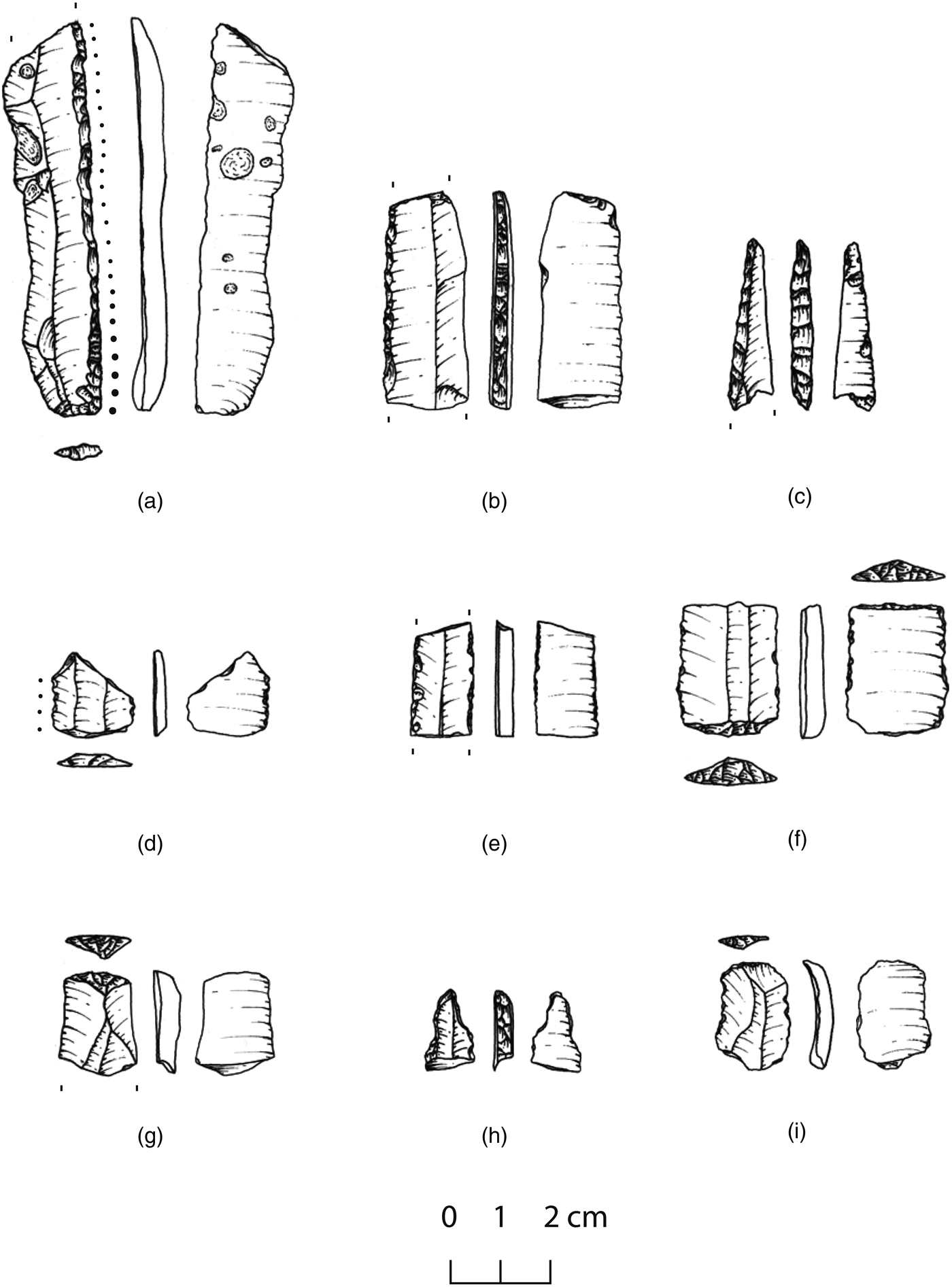
Phase-diagnostic pieces are by no means absent from the MNG deposits. The majority, however, were retrieved from contexts we diagnosed as mixed (e.g., the ‘dump’ deposits of the Λ trenches; see above). That prevents us from establishing a stratigraphically documentable sequence. In Figs 19 and 20 we illustrate a few pieces and provide information about their chronostratigraphic contexts.Footnote 18
Phase-diagnostic flaked stone pieces from mixed deposits: (a) bifacially worked triangular point (jasper or radiolarite), FN; (b) bifacially worked triangular point, ‘killed’ ? (jasper or radiolarite), FN; (c) arrowhead (jasper or radiolarite), EBA; (d) drill (yellow flint), FN or LN. Drawings: O. Metaxas.

Flaked stone from secure chronostratigraphic contexts: (a) retouched blade with gloss (grey flint), FN; (b) segment of backed (pressure?) blade (yellow flint), FN; (c) drill/perforator on burin spall (chalcedony?), FN; (d) element of composite cutting tool, gloss on longer edge (grey flint), FN; (e) blade segment with retouch/wear on both edges (grey flint), FN; (f) element of composite cutting tool with retouched truncations, light use wear (dark-coloured, high-quality chert), FN; (g) scraper on mesial blade fragment (grey flint), LN; (h) drill bit on blade segment (radiolarite), LN; (i) distal blade fragment, use wear on long edges, short steep retouch on distal end: a blade recycled as scraper? (jasper or radiolarite), FN. Drawings: O. Metaxas.

Macrolithics (ground stone)
The macrolithic sample from the excavation and survey of MNG comprises some 400 specimens. About 240 of those are securely diagnosed on the basis of traces of manufacture and/or use. The remainder, mostly small fragments, lack such traces but are made from the same kinds of rocks as the secure items. The main rocks in question are serpentinites, gabbros, limestones, marbles, sandstones, gneisses and fine- and medium-grain conglomerates. Some of those rocks outcrop along the hills around Kitrini Limni, but others reached MNG from farther afield (e.g., Aliakmon River). Some specimens are made from stones of striking visual properties.
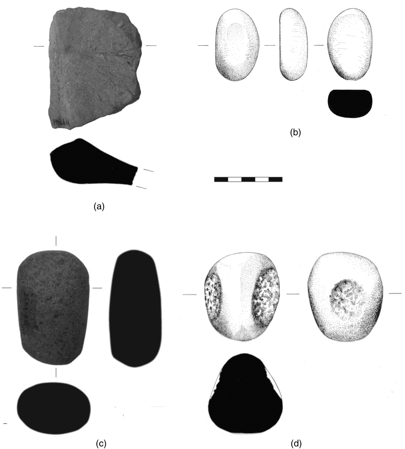
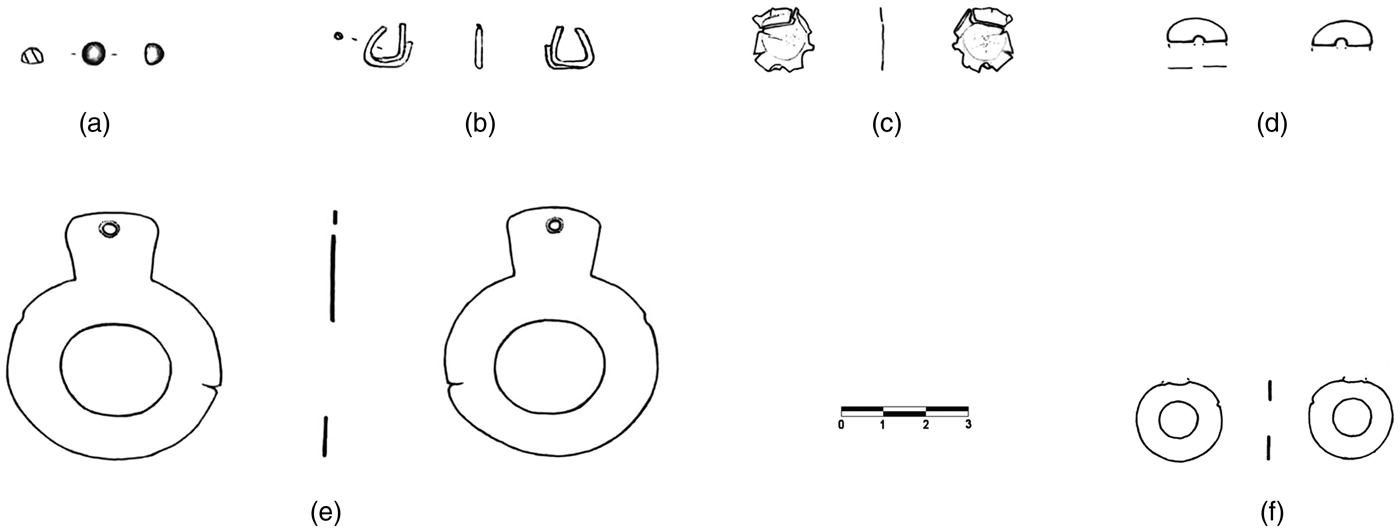
On the basis of techno-morphological characteristics, the sample has been divided into the following groups:
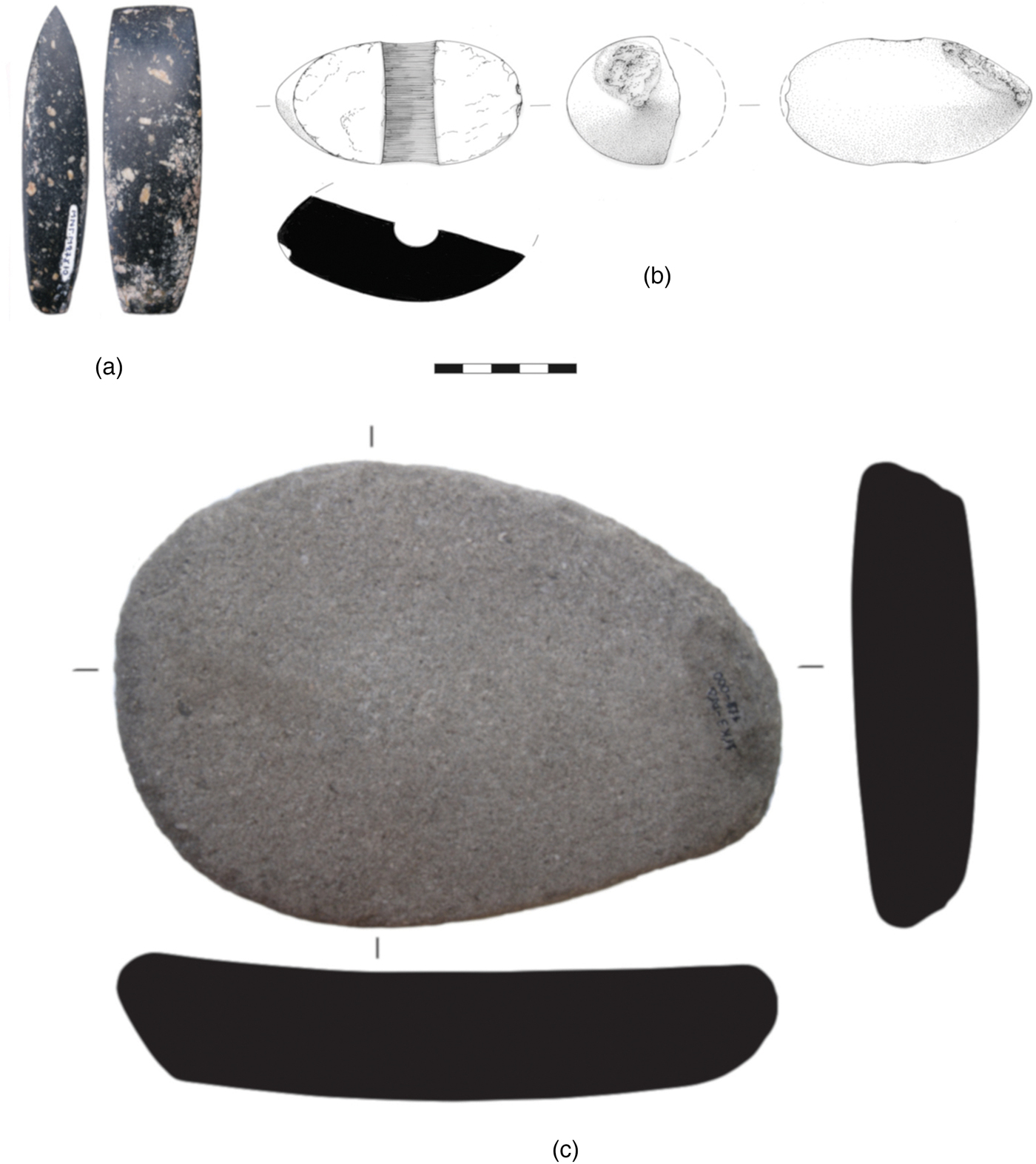
1. Celts (Fig. 21a). The group consists of 26 finished tools, five small fragments possibly from finished tools, at least five unfinished specimens, and several byproducts of manufacture. Small celts are as a rule made from serpentinite, while larger, heavier ones are from gabbro (see also Stroulia, Reference Stroulia, Alram-Stern, Gallis and Toufexisforthcoming). The techniques employed in the manufacture of celts were grinding, pecking, flaking and sawing. The presence of unfinished specimens and manufacture byproducts indicates on-site production of celts. Flaking as a technique for celt making and evidence for on-site celt manufacture are rare in the Greek Neolithic (Stroulia Reference Stroulia2018a, 55).
Fig. 21.(a) One face and profile of large celt, FN; (b) three views and longitudinal section of ‘macehead’, surface survey find (colour online); (c) work face and sections of passive grinding tool, surface survey find (colour online). Drawings: (b) R. Robertson; (c) T. Gouliafas. Photos: A. Stroulia.

2. Perforated objects (‘mace-heads’). This group comprises seven finished specimens from gabbro, marble and sandstone, as well as two drill cores. Megalo Nisi Galanis is one of about 20 Neolithic sites in Greece from which stone ‘mace-heads’ have been reported. Like most other examples, those from MNG are fragmentary. Five of them are dated to the LN and FN phases, as are most Greek specimens (Stroulia, Reference Stroulia, Alram-Stern, Gallis and Toufexisforthcoming). While three of the MNG artifacts are of the usual spheroidal shape, the other four have a rhomboidal or subrectangular shape rare among specimens reported from elsewhere (Fig. 21b). Drill cores indicate on-site production and the use of hollow drills. The use of ‘mace-heads’ remains an enigma (see Stroulia Reference Stroulia, Papathanasiou, Parkinson, Pullen, Galaty and Karkanas2018b, 230 and references therein), but the well-polished, un-faceted surfaces of the MNG pieces leave no doubt about the amount of care and effort invested in their production.
3. Grinding tools. This group includes about 50 artifacts that were used in grinding foods and, possibly, other substances. Conglomerates, gneisses and sandstones are the main raw materials. Most specimens are preserved as fragments, as is commonly the case in many sites (see Stroulia Reference Stroulia, Papathanasiou, Parkinson, Pullen, Galaty and Karkanas2018b, 204, 208). A complete example from MNG is a relatively small, oval passive specimen measuring 23.1 x 16.2 x 4.4 cm (Fig. 21c). According to use-wear analysis, its work face served for grinding non-oily vegetal substances, perhaps cereals (L. Dubreuil, pers. comm.).
4. Abrading tools (Fig. 22a). Included here are about 20 tabular pieces and flattish cobbles from sandstone used, without prior modification, mainly in the passive mode. One specimen has a groove with a pointed V-section. Abrading tools of similar morphology, raw material and use wear are known from other sites in the region, e.g., Servia (Ridley, Wardle and Mould Reference Ridley, Wardle and Mould2000, 151–5) and Kremasti-Kilada (Stroulia, pers. observation). They were probably used for shaping and sharpening artifacts of bone, wood and stone.
Fig. 22.(a) One face and transverse section of abrading tool, MN–LN transition; (b) faces, profile, and transverse section of marble tool with smoothed surfaces, FN; (c) one face and sections of elongated gabbro percussive tool, surface survey find; (d) two views and section of globular gabbro percussive tool, FN. Drawings: (a) and (c) T. Gouliafas; (b) and (d) R. Robertson. Photos: A. Stroulia.
5. Tools with smoothed surfaces. This group comprises some 70 water-rolled pebbles and cobbles, most of them from limestone, gabbro, and marble (Fig. 22b). They were used actively without prior modification, probably for burnishing ceramic containers, smoothing the surfaces of clay facilities or processing animal skins. Prolonged use resulted in shape modification of some of those specimens; light use in other cases caused only a change of surface texture. A few items bear additional percussion wear.
6. Percussive tools (e.g., pounders and hammerstones). This group includes 20 or so specimens, most of them from gabbro. Most tools are elongated cobbles that were ground to shape and bear percussion marks on their ends (Fig. 22c). The rest are globular cobbles with evidence of use on portions of their body (Fig. 22d). A few specimens bear additional abrasion wear.
7. Miscellanea. This heterogeneous group includes specimens that could not be assigned to the above groups. Examples are pieces of hematite used to produce pigment or colour other objects, small pointed tools, and fragments that may belong to tools or ornaments.


Gold jewellery
Approximately 130 items from the excavation at MNG qualify as jewellery. Most of them are discoidal beads from various stones, but the group also includes many items from Spondylus shell, other bivalves, bone and clay. It also includes four gold pieces, which are described below. The pieces are:
1. Minute spheroid (Fig. 23a), weight 0.2 g. One side is flattened and somewhat rough, the rest is finely polished. The piece must have come loose from a larger item, e.g., a pin or a miniature sceptre.
2. Penannular ring (Fig. 23b), weight 0.2 g. Made of two separate strips of gold sheet fashioned into narrow tubes and welded or hammered together. The current triangular configuration of the piece suggests deformation, possibly (not necessarily) in a depositional context.
3. Discoid from gold sheet in two fragments (Fig. 23c), weight less than 0.1 g. Shredded along its periphery. Perhaps it was part of the decoration of some kind of cloth.
4. Fragment of discoidal piece from gold sheet with remnant of a hole (Fig. 23d), weight less than 0.1 g. Part of a pendant.
Gold jewellery from MNG (a–e) and Kleitos (f). See section ‘Gold jewellery’ for details. Drawings: T. Vakouftsi. Digital editing: A. Karadimou, S. Vlahopoulou.

The first two of the above pieces were retrieved from the mixed deposits of the ‘dump’ in trenches Λ33 and Λ34. The other two pieces came from secure FN deposits in trenches Μ26 and Μ27. A fifth piece is a ‘chance find’ from the surface of MNG (Karamitrou-Mentesidi Reference Karamitrou-Mentesidi2005, 521–2). It is a finely preserved ‘ring-idol’ weighing 4.4 g (Fig. 23e). Beyond MNG but still in Kitrini Limni, the fully excavated LN and FN site of Kleitos (see Ziota Reference Ziota, Stefani, Merousis and Dimoula2014) yielded the main, circular part of another ‘ring-idol’ (Fig. 23f). No further pieces of Neolithic gold jewellery are thus far published from Macedonia west of Mount Vermio, but this will probably change once the results of the fieldwork currently in progress throughout the region are published.
Gold jewellery comparable to that from MNG is known from Anatolia (especially the Pontic region), continental Greece and the Balkans (see, e.g., Zimmermann Reference Zimmermann2007; Dimakopoulou Reference Dimakopoulou and Dimakopoulou1998; Leusch et al. Reference Leusch, Armbruster, Pernicka and Slavčev2015). The great majority of pieces derive from illicit excavations. Their archaeological contexts and precise chronology are therefore matters of speculation. The most significant exception to that pattern is provided by the Varna I cemetery in northeast Bulgaria, radiocarbon-dated between 4560 and 4450 bc (Higham et al. Reference Higham, Chapman, Slanchev, Gaydarska, Honch, Yordanov and Dimitrova2006; Chapman et al. Reference Chapman, Higham, Slavčev, Gaydarska and Honch2006). That cemetery provides clear evidence for social hierarchy in northeast Bulgaria, with a few paramount chiefs and many followers. The evidence from Kitrini Limni is too limited at the moment to support claims for a comparable hierarchy.
The natural sources of the MNG and Kleitos gold are not determined. Placer gold exists, or is known to have existed, in many areas of the east Balkans (see Leusch et al. Reference Leusch, Armbruster, Pernicka and Slavčev2015, fig. 1). The source nearest to Kitrini Limni is the Ayios Minas ravine in the vicinity of modern Servia, where placer gold was reputedly mined in Ottoman times (Charistos Reference Charistos2010, 45-6, and references therein). Many sources of placer gold are known in central Macedonia, 100–150 kilometres to the east. There, gold mining began in the Classical period, if not earlier. In some places it was still pursued in early twentieth century (Vavelidis and Andreou Reference Vavelidis and Andreou2008; Andreou and Vavelidis Reference Andreou, Vavelidis, Meller, Risch and Pernicka2014; Andreou pers. comm.).
CONCLUSION
Megalo Nisi Galanis was the first site in Kitrini Limni to be systematically surveyed and excavated. It also was the second prehistoric site in the entire region of west Macedonia, following Servia, to be excavated after 1950. Today, Servia and MNG are the only excavated multi-period sites in the region with published stratified sequences covering substantial segments of the Neolithic. The MNG sequence, in particular, covers the period from the Middle to the Final Neolithic. Moreover, EBA deposits are present in the higher parts of the sequence at both Servia and MNG. While both sequences have their strengths (e.g., phases represented at good resolution) and weaknesses (stratigraphic hiatuses), together they provide precious evidence for the chronology of other, short-lived sites and sites with problem-ridden stratigraphies. In the case of MNG, detailed consideration of site formation processes and careful distinctions between disturbed/mixed and more pristine deposits have significantly enhanced our understanding of the site's chronology and the dating of key parts of the cultural sequence.
Despite its limited extent, the excavation at MNG yielded significant new knowledge on numerous issues. The stratigraphic sequence at the site begins with a thin slice (5–10 cm) of MN deposits, formed probably toward the end of the northern Greek Middle Neolithic. The slice rests directly on natural deposits of the early Holocene. Beside MN material, it contains a small number of potsherds dateable to the Early Neolithic. Those potsherds indicate the presence of EN deposits in a part of the site beyond the excavated trenches. The EN sherds found their way into MN deposits as the MN inhabitants of the site helped themselves to earlier settlement debris to suit their purposes. But the main point is that MNG was already inhabited in the Early Neolithic. A 14C date from the same context as the EN sherds indicates human presence at the site before the end of the seventh millennium bc.
The replacement of red-slipped by black burnished pottery in the northern Greek Neolithic has long been thought to mark the passage from the Middle to the Late Neolithic. Heurtley, working at Servia some 90 years ago, already observed that this passage was a prolonged process (Heurtley Reference Heurtley1939, 66). His observation has been vindicated by new excavations at a few sites in Macedonia, including Servia, and by our findings at MNG, where the replacement of the old by the new pottery recipe was clearly gradual and the process lasted between 100 and 200 years. We designated that period as the ‘MN–LN transition’, a descriptive label, fit for the situation. The MN–LN transition at MNG is bracketed by radiocarbon dates between 5750 and 5200 bc. We do not know what prompted the adoption of the recipe for black burnished pots in the course of the Middle Neolithic. The fact, however, that typical MN and black burnished pottery coexisted for a long time strongly suggests continuity rather the rupture: in other words, the technology for black burnished pottery probably developed out of MN ceramic traditions.
Dated by four 14C dates between 5200 and 5080 bc, the Late Neolithic at MNG follows on the heels of the MN–LN transition. We have argued that the most distinctive feature of the LN phase, the black topped pottery and its subtle ‘rippled’ decoration, was the result of innovations that were grafted onto the recipe for making the black burnished pottery of the preceding phase. Once more, that is, we argued for continuity, not rupture. The upper part of the LN deposits was removed early in the following phase, the Final Neolithic. As a result, we cannot trace the course by which the LN techno-traditions at MNG were transformed into those of the Final Neolithic, so drastically different from the traditions that preceded them.
Up to the Late Neolithic, non-calcareous sediments were brought onto the site and were used as construction materials. That changed in the early Final Neolithic, when sandy, calcareous earth became the norm for construction, and at the same time potters turned to calcareous clays for many of their pastes. But these were hardly the only changes. The FN ceramic repertory is extraordinarily diverse in terms of shapes, clay bodies, surface treatments and, ultimately, recipes for pot making. Large, expediently built vessels are numerically dominant, but smaller, finely made ones are present too. The latter can bear elegant incised or painted patterns. ‘Crusts’ of various colours and compositions also occur. ‘Strainers’, ‘scoops’ and angular, box-like containers are a few other highlights. We identified a handful of sherds that may represent imports from Thessaly and east Macedonia.
The early Final Neolithic at MNG is radiocarbon-dated to about the middle of the fifth millennium bc. It may have lasted, however, until late in that millennium. Its upper deposits have been muddled by ploughing. In addition to FN materials, the plough zone contains scores of EBA ceramics and a few pieces that belong to the Middle Bronze Age. Although not dateable with precision, such finds make it clear that the part of the site we excavated was inhabited, however sparsely or intermittently, until about 1800 bc.
Marine shells, birch bark tar, gold jewellery and, especially, high-quality siliceous stones, including obsidian from Melos, demonstrate that Neolithic MNG maintained transactions with regions far beyond west Macedonia. The fact that it shared ceramic traditions with communities extending from Thessaly to the Danube makes that conclusion indubitable. Flaked stone arrived at the site mainly as near-finished products, but obsidian was worked on site, most probably by the artisans who carried it over long distances. Celts and ‘mace-heads’ were also manufactured on site by expert craftspeople.
The history of the marshes in Kitrini Limni has been an issue for us since the first days of our fieldwork. Did a marsh exist in the basin floor during (parts of) the Neolithic? If so, how extensive was it? Was an expansion of the marsh a factor relevant to the abandonment of the basin floor in the course of the Bronze Age or later? The fluctuations of the marshes, seasonal and long-term, played without a doubt an important role in the occupational history of the basin (and not only in prehistory). Had we conducted fieldwork around 1950, issues of the sort would have been more tractable than in the 1980s. Artificial drainage of the basin floor, strip-mining and deep ploughing after 1950 eliminated crucial evidence relevant to our questions. All said, we submit that the basin floor was probably drier in the Neolithic than in later times, and that the marshes expanded significantly in the Late Holocene, perhaps during the Historical period, at which time marsh waters encroached upon the periphery of MNG.
ACKNOWLEDGEMENTS
Areti Hondroyanni-Metoki supervised the 1993 excavation and wrote the section on gold jewellery (translated by Michael Fotiadis); Alexandra Kalogirou wrote all parts about pottery; Yannis Maniatis wrote the section on radiocarbon chronology; Anna Stroulia wrote the section on ground stone tools; Christina Ziota with Michael Fotiadis drew the scarps; Michael Fotiadis wrote the remaining sections. Financial support for the study of the MNG materials was provided by the Institute for Aegean Prehistory (USA), Indiana University (USA), the Dr M. Aylwin Cotton Foundation (UK) and the University of Ioannina (Greece). We are indebted to two anonymous reviewers for their significant comments on our original submission to the Annual of the BSA. We are also indebted to colleagues and friends for essential help in several aspects of the article: Stelios Andreou, Thanos Giannopoulos, Yannis Diamantopoulos (d. 2018), Paul Halstead, Duska Urem-Kotsou, Rainer Rumold and Mike Strezewski.
SUPPLEMENTARY MATERIAL
Online Supplementary Material is available for this article here: https://doi.org/10.1017/S0068245419000145.