




Introduction
Mount Aragats, the highest peak in the Republic of Armenia, is not only a prominent geographical landmark but also a crucial hydrological source within the Armenian Highlands. Numerous small and large rivers, spring torrents, and springs flow from all sides of the mountain (Figures 1–3). As a result, Aragats is covered by cultivable soils, making its lower slopes some of the most densely populated agricultural regions in Armenia. This distinctive feature of Aragats is emphasized across nearly all historical periods, but is particularly well-documented in the works of scholars from the late 19th and early 20th centuries (cf., e.g., Saghatelov, Reference Saghatelov1879: 61; Dingelstedt, Reference Dingelstedt1883: 105–108; Lynch, Reference Lynch1901: 136, 148; Ter-Movsisyan, Reference Ter-Movsisyan1912: 236; Virabyan, Reference Virabyan1975: 155; Kajberuni, Reference Kajberuni2003: 13–14).
The Republic of Armenia and the location of Mount Aragats. Map by A. Ananyan, Created in 2025.

Figure 1. Long description
The map of the Republic of Armenia features detailed topographic elements, including elevation, rivers, and international boundaries. Mount Aragats, the highest peak in Armenia, is prominently marked along with the capital city, Yerevan, and Lake Sevan. The map uses color shading to represent different elevations, with darker shades indicating higher altitudes. Key rivers and their flow directions are depicted, illustrating the hydrological network originating from Mount Aragats. The international boundaries of Armenia are clearly outlined, providing a geographical context within the larger region.
The Transcaucasian Region of the Russian Empire with indicated irrigation zones. After Psarev Reference Psarev1888; redrawn by A. Ananyan and R. Hovsepyan, 2025.

Figure 2. Long description
The map illustrates the Transcaucasian Region of the Russian Empire, highlighting various irrigation zones. It includes key geographical features such as Mount Aragats, Sevan Lake, and the Caspian Sea. Different colors and patterns are used to indicate irrigated areas in lowland and upland zones, as well as areas irrigated by canal systems. The map also shows overlapping zones cultivated by spring floods of the Kura and Araxes rivers, and primary and secondary irrigation canals designed by British engineers Bell and Gabo in 1863.
The Mount Aragats area with toponyms and principal water sources discussed in the text. Map by R. Gabrielyan and A. Ananyan, 2025.

Figure 3. Long description
The map depicts the Mount Aragats area with various settlements marked by red dots. It includes major rivers, lakes, and channels, highlighting the principal water sources in the region. Key settlements such as Aygabats, Garni, Artik, and Aparan are labeled. The map also shows the geographical features and the distribution of water bodies around Mount Aragats, the highest peak in the Republic of Armenia.
The purpose of this contribution is to examine the water infrastructure of Mount Aragats during the late 19th and early 20th centuries, using the Twelve Bander irrigation system located on the mountain’s southern slopes as an example. This area is long known for its reliance on communal irrigation structures of local rural communities up to ca. 5000 inhabitants.
The word band, as used by the Armenians, is of Iranian origin and means ‘tie’ or ‘knot’ (Acharean, Reference Acharean1926: 406). Amongst the Iranian peoples, the same word band signifying ‘Zoroastrian dams’ describes any bank or wall used for the impounding, diversion, or guiding of flood or perennial water (cf. Raikes, Reference Raikes1964: 26). In Armenia, the band refers to the section at the source (headwaters) of a canal, through which water is diverted. In this area, a sturdy barrier is typically built, as it bears the full pressure of the water entering from the sources (cf. Gabrielyan, Reference Gabrielyan2024a, Avan, record no. 240722-1; 2024, Lernarot, record no. 240729-1). Another popular name for slope canals was sekiv (mountain route) (cf. Ter-Yovhannesean, Reference Ter-Yovhannesean1965: 24).
The Twelve Bander irrigation network has not previously been investigated as a distinct research topic. Moreover, the last living witnesses of its former function and maintenance will soon be gone, making it urgent to record their specific knowledge. To address this gap, the research presented here integrates multiple strands of evidence, including historical sources, oral testimonies, architectural features, and spatial distribution patterns.
Particular research objectives of this contribution are as follows: 1. to document the Twelve Bander irrigation system through integrated field survey, GIS-based spatial analysis, architectural recording, and ethnographic mapping of terminology and toponymy, 2. to reconstruct the canal sequence, water intake structures, course modifications, and distribution routes from the headwaters of Amberd river to the irrigated settlements, 3. to evaluate the potential continuity of the Twelve Bander system under a longue durée framework by combining historical texts, medieval inscriptions, architectural parallels, and landscape archaeology, 4. to critically assess existing hypotheses of pre-medieval or prehistoric origins of Aragats irrigation networks and determine whether material evidence supports such claims, 5. to analyse how water distribution was governed among neighbouring villages, focusing on allocation schedules, seasonal variations, conflict resolution, and the role of custodial institutions, 6. to examine the canal’s role in sustaining dense agricultural settlement, livestock use of mountain pastures, and adaptation strategies to climatic and hydrological variability, 7. to situate the Twelve Bander within broader regional irrigation systems, assessing shared engineering traits, divergences, and historical interactions, and 8. to contribute a scientifically grounded model for understanding mountain irrigation systems in Armenia, providing implications for the history of water management in highland societies.
The study area and its geo-environmental settings
The study area is situated on the south slope of Mount Aragats, in the Ashtarak region. It covers the upper Amberd River gorge and the villages between Orgov in the East, Aruch in the West, Shamiram in the South, and Lernarot in the North.
The massif of Mount Aragats was formed as a result of prolonged and recurrent volcanic activity (Figure 4). The bedrock beneath it consists of intensely deformed sedimentary formations, dated to the Palaeozoic, Upper Cretaceous, Palaeocene–Middle Eocene, and, in some sections, the Oligocene and Miocene periods. The foreland zones surrounding Aragats, specifically the Ararat, Shirak, and Aparan depressions, are extensive subsidence areas composed predominantly of Neogene and Quaternary sediments (Meliksetian, Reference Meliksetian2012; Hovhannisyan et al., Reference Hovhannisyan, Avetisyan and Bobokhyan2021).
Geological structure of Mount Aragats. Map and Diagram by A. Hovhannisyan, 2025.

Figure 4. Long description
The geological map of the Mount Aragats massif illustrates the diverse sediment types and volcanic features in the region. Key elements include eluvial, alluvial, and glacifluvial sediments, as well as various types of volcanic rocks such as ignimbrites, basaltic lava flows, and dacites. The map highlights the central craters of the upper Pliocene Aragats polygenetic volcano and the centers of Quaternary volcanoes. Specific locations such as Mount Aragats and Mount Tirinkatar are labeled with their respective elevations. The legend provides detailed information on the different geological formations and their compositions.
The volcanic massif of Aragats, with a thickness of approximately 1.5 km, has the shape of an enormous convex shield featuring four summits at its centre. It is composed of a diverse range of lavas (andesite-basalts, andesites, andesite-dacites, and rhyolites) and their associated pyroclastic deposits, such as tuffs and tuff breccias, which are largely overlain by sedimentary accumulations from the Quaternary period. At an average elevation of 1000 metres above sea level, the massif spans a diameter of roughly 60 kilometres, with its peaks rising between 3879 and 4090 metres. The four jagged summits are remnants of a volcanic cone encircling a central crater, shaped by glacial and fluvio-glacial erosion, measuring approximately 2 km in diameter and 300–400 metres in depth. In the summit area, 10 cirques are found, each ranging from 3 to 4 km in length and 1 to 2 km in width. Aragats was, until the second half of the twentieth century, the principal centre of contemporary glaciation in Armenia, possessing a glaciated surface area of about 2–3 km2. Currently, a total retreat of perennial ice was observed, with only some active rock glaciers and névè moraines surviving (Carrasco et al., Reference Carrasco2025: 17).
From a hydrographic perspective, Aragats is of particular importance. In addition to the numerous rivers that originate from its peaks, the mountain hosts a significant number of small lakes. The amount of precipitation increases progressively with altitude (Galstyan et al., Reference Galstyan, Sfîcă and Ichim2014: Figure 1). Seasonally, a portion of the precipitation evaporates, another portion infiltrates into the soil, and the remainder collects into streams and rivers that flow toward the plains. At higher elevations, precipitation falls primarily in the form of snow, accumulating in substantial quantities and providing critical water resources during the summer melt season.
In earlier geological periods, nearly half of the slopes of Aragats were covered in ice, as evidenced by glacial scarring on exposed rock surfaces. In addition to glacial and snowmelt sources, the mountain’s water reserves are also stored in lakes, 43 of which are located on its northern and western slopes. Historically, up to 100 lakes have been recorded across the Aragats massif (Hovhannisyan et al., Reference Hovhannisyan, Avetisyan and Bobokhyan2021). The largest of these is Lake Kari, situated on the southern slope (Figure 5).
Lake Kari covered with ice and the Karakap 3 vishap stela relocated in modern times to the lakeshore. Photograph by A. Bobokhyan, 2015.

Figure 5. Long description
A landscape photo featuring Lake Kari, partially covered with ice, set against the backdrop of Mount Aragats, the highest peak in the Republic of Armenia. The Karakap 3 vishap stela, an ancient stone monument, is prominently positioned on the lakeshore. The scene is characterized by snow-covered slopes and patches of green grass, with a partly cloudy sky overhead.
These lakes are primarily fed by spring snowmelt. Their water abundance is closely related to the size of the scree-covered areas located above them. These screes play a vital role in snow accumulation, as their lack of soil and vegetation prevents infiltration, channelling the meltwater downslope. These geological features are especially widespread at higher elevations and account for the numerous springs emerging from the massif. Unsurprisingly, these springs attract herders who seasonally migrate with their livestock to the high-altitude summer pastures.
While the upper parts of Aragats are rich in water resources, the lower slopes often suffer from water scarcity. As spring water descends from higher elevations, its volume decreases, mostly due to infiltration into the porous volcanic substrate. This phenomenon is attributed to the fractured nature of andesite-basalt, which absorbs atmospheric precipitation and gradually releases it during the spring melt into the lower zones. However, because many of these lower areas lack impermeable layers, water infiltrates into the shallow subsurface strata. Only in specific instances, where water encounters vertical fractures in the volcanic bedrock, do springs form and flow visibly on the surface (Karapetyan, Reference Karapetyan1934: 18–23; Zavaritsky, Reference Zavaritsky1944; Djerbashyan, Reference Djerbashyan2010; Meliksetian, Reference Meliksetian2012; Hovhannisyan et al., Reference Hovhannisyan, Avetisyan and Bobokhyan2021).
Aragats possess a distinct natural terraced structure. The transition between terraces is marked by slopes of varying gradients, with steeper inclines observed in the northern and northeastern parts of the mountain, as well as in the Amberd River gorge area on the southern slopes, where the Twelve Bander system takes its roots (Figure 6). Ascending Aragats gives the impression of climbing a series of natural steps, each one forming a fertile plateau (cf. Dingelstedt, Reference Dingelstedt1883: 106–107; Kalantar, Reference Kalantar1895: 73). This unique geomorphological feature has had a direct influence on the formation of a culturally distinctive landscape.
Sources of the Amberd River. Photograph by A. Bobokhyan, 2014.

Figure 6. Long description
The image depicts the upper parts of Aragats, a mountain with snow-covered slopes and patches of green vegetation. A valley in the foreground features a small stream flowing through it. The stream appears to be fed by melting snow from the higher elevations. The landscape shows a mix of snow, rock, and green vegetation, illustrating the water resources and their descent from higher elevations. The image highlights the natural water cycle and the geological features of the region, including the porous volcanic substrate that absorbs atmospheric precipitation.
In the settlements located on the slopes of Aragats, a diverse array of crops was cultivated. The selection of crops was contingent on the terrain’s vertical zoning and irrigation availability. On plots irrigated by spring floods and supplemented by rainfall, grain crops such as wheat, rye, and barley were predominantly cultivated. Furthermore, at higher elevations (1600–2700 m), sowing was conducted in spring to mitigate frost risk. In lowland areas with permanent irrigation (850–1800 m), it was feasible to cultivate fruit trees, including apple, pear, peach, grape, and plum trees, among others (Tumanyan, Reference Tumanyan1934: 4–10).
Methodological approaches
This study combines historical, ethnographic, and geospatial data to reconstruct and contextualize the water distribution system of Mount Aragats, using Twelve Bander as an example.
Historical-Archival Analysis. Primary historical documentation was gathered from 19th- and early 20th-century Russian imperial and early Soviet-period sources, traveller accounts, hydrological reports, cadastral records, and local administrative correspondence. These texts were critically analysed to extract details on canal structures, water allocation practices, community ownership, and seasonal variability. Special attention was given to consistency and discrepancies between sources over time, with cross-verification through multiple publications.
Ethnographic Fieldwork. Oral-history interviews were conducted with residents of the rural communities of the Ashtarak region (Avan, Lernarot, Tegher), many of whom possess intergenerational knowledge regarding local canal management practices. In total, twenty interviews were carried out, of which data from seven were deemed sufficiently relevant and reliable for inclusion in this study. The primary limitation of the interview dataset stems from the absence of knowledgeable representatives of the appropriate senior generation among some respondents, which restricted the depth of historically grounded information. These accounts were recorded, transcribed, and analysed to document traditional techniques of canal maintenance, seasonal irrigation patterns, and water conflict resolution mechanisms. The terminology and toponymy used by informants were also recorded to assess continuity in local hydrological knowledge.
Field Surveys. Fieldwork was carried out along the southern slopes of Mount Aragats (since 2012), especially in the area surrounding the Tirinkatar and Karmir Sar peaks, to identify remnants of canals and embankments, and related features. The preserved sections were mapped and described, with particular focus on construction techniques such as dry-stone masonry, terrace formation, and secondary embankments. A Geographic Information System (GIS)-based approach was used to trace the spatial distribution of canals, natural water sources (springs and lakes), and terrain profiles.
Comparative Analysis. Comparative examples of irrigation systems from other regions of Armenia, particularly concerning various historical phases, were used to identify technical and spatial continuities. Features such as canal cross-sections, construction material, and water management strategies were compared with those of the Twelve Bander system.
Results
The Twelve Bander irrigation system: field observations
Our field research indicates that the Twelve Bander irrigation system remains today in relatively good condition despite its abandonment decades ago. Our observations were the following:
-
1. The headwaters of the canals are still visible on the eastern slopes of the Tirinkatar and Karmir Sar heights (Figures 7–18, Table 1). The canals flew out from the steep sections and headed westward to the relatively flat areas, where their direction was controlled by dual stone-earth embankments. After splitting into different canals, the water spread across the villages Shamiram, Avan, Lernarot, Ujan, Khnusik, Upper Sasunik, Kosh, Aghdzk, Orgov, Aruch, and Tegher.
Figure 7.The Twelve Bander canal system in the Amberd Gorge sector. Map by R. Gabrielyan and A. Ananyan, 2025.

Figure 7. Long description
The topographic map displays the Twelve Bander canal system in the Amberd Gorge sector. The map includes contour lines indicating elevation, with rivers and irrigation canals marked in blue. Key locations and elevations are labeled, providing a detailed view of the terrain and water distribution in the area.
Figure 8.The Twelve Bander canal system viewed from south to north. Photograph by A. Hakhverdyan, 2025.
Figure 9.The Twelve Bander canal system viewed from south to north. Photograph by A. Hakhverdyan, 2025.
Figure 9. Long description
A winding dirt road cuts through a valley between two hills. The hills are covered with sparse vegetation and scattered rocks. The sky above is partly cloudy, with patches of blue sky visible between the clouds. The road appears to be the only man-made structure in the otherwise natural landscape.
Figure 10.The Twelve Bander canal system viewed from north to south. Photograph by P. Hnila, 2017.
Figure 11.The Twelve Bander canal system from an alternative north-to-south perspective. Photograph by A. Hakhverdyan, 2025.
Figure 11. Long description
The image presents an aerial view of the Twelve Bander canal system, captured from a north-to-south perspective. The landscape features rolling hills with multiple canals winding through the terrain. The canals are visible as distinct lines cutting through the green and brown hues of the hills. The terrain appears rugged with varying elevations, and the canals follow the contours of the land, creating a network of irrigation paths. The image highlights the intricate design and layout of the canal system, showcasing its historical significance and engineering.
Figure 12.The Twelve Bander canal system, details of wall construction in the central section of Amberdadzor. Photograph by A. Ananyan, 2024.
Figure 13.The Twelve Bander canal system, details of walls in the central-eastern section of Amberdadzor. Photograph by A. Bobokhyan, 2024.
Figure 13. Long description
The image captures the intricate details of the walls in the central-eastern section of the Twelve Bander canal system located in Amberdadzor. The walls are composed of a mix of green vegetation and exposed rocks, creating a rugged and natural appearance. The terrain is uneven with patches of grass and small streams running through it. The overall scene is set against a clear blue sky, highlighting the natural beauty of the landscape.
Figure 14.The Twelve Bander canal system, details of walls in the central-northern section of Amberdadzor. Photograph by R. Gabrielyan, 2024.
Figure 14. Long description
The image depicts the Twelve Bander canal system in the Amberd Gorge sector. The scene features stone-earth embankments that control the direction of the canals, which flow westward from the steep eastern slopes of the Tirinkatar and Karmir Sar heights. The embankments are constructed without mortar and have a semi-arched shape facing the slope, designed to withstand higher water pressure. The surrounding area is covered with green vegetation and wildflowers, indicating the relatively good condition of the abandoned irrigation system despite its disuse for decades.
Figure 15.The Twelve Bander canal system, detail of a wall in the northern section of Amberdadzor. Photograph by A. Bobokhyan, 2024.
Figure 15. Long description
The image shows a close-up view of a stone wall in the northern section of Amberdadzor, part of the Twelve Bander canal system. The wall is constructed from large, irregularly shaped stones and is surrounded by lush vegetation, including various types of grasses and wildflowers. The stones are stacked in a somewhat haphazard manner, creating a rustic and ancient appearance. The vegetation around the wall is dense and vibrant, with a mix of green and yellow hues, indicating a healthy and thriving ecosystem. The wall itself appears to be in relatively good condition, despite its age, and shows signs of weathering and erosion. The overall scene conveys a sense of historical significance and natural beauty.
Figure 16.Segment of Twelve Bander canal 1. Photograph by R. Gabrielyan, 2024.
Figure 17.The Twelve Bander canal system, drawing of walls in the central section of Amberdadzor. Drawing by A. Hakhverdyan, 2024.
Figure 17. Long description
The image presents a detailed cross-sectional drawing of the Twelve Bander canal system in the central section of Amberdadzor. The drawing highlights the intricate network of canals, showing their paths and the surrounding terrain. The canals are depicted with dual stone-earth embankments controlling their direction. The elevation and spatial relationships between different sections of the canals are clearly illustrated. The drawing also includes annotations and labels that identify key features and components of the canal system. The terrain is shown with varying elevations, and the canals are depicted flowing from the steep sections to the relatively flat areas. The image provides a comprehensive view of the canal system’s structure and layout.
Figure 18.The Twelve Bander canal system, detail from a drawing of walls in the central section of Amberdadzor. Drawing by A. Hakhverdyan, 2024.
Figure 18. Long description
The drawing depicts the central section of the Twelve Bander canal system, highlighting its relatively good condition despite abandonment. The top section shows a dense network of canals and structures on elevated terrain. The bottom section presents a longitudinal cross-section from 2000 to 2024, illustrating the evolution of the canals and their transformation into roads over time. Key features include visible canals in the years 2000, 2005, and 2010, with annotations indicating where canals turned into roads by 2015 and 2020. The spatial arrangement and historical changes in the irrigation system are clearly marked, providing a comprehensive view of its development and current state.
Table 1.Data on the location of the Twelve Bander
Table 1 Long description
A table titled Data on the location of the Twelve Bander. The table has 12 rows and 4 columns. The columns are labeled as follows: Canal, Length (in metres), Elevation of the spring and the point where it emerges from the slope, above sea level (in metres), Coordinates of the spring section, and Coordinates of the section leading out of the slope. The table presents data for 12 canals. Row 1: Canal 1, Length 5470, Elevation 2531-2420, Coordinates of the spring section Y 40.433130 X 44.162248, Coordinates of the section leading out of the slope Y 40.397289 X 44.188164. Row 2: Canal 2, Length 4814, Elevation 2492-2394, Coordinates of the spring section Y 40.426596 X 44.163159, Coordinates of the section leading out of the slope Y 40.399095 X 44.191333. Row 3: Canal 3, Length 4333, Elevation 2461-2395, Coordinates of the spring section Y 40.422594 X 44.164893, Coordinates of the section leading out of the slope Y 40.399251 X 44.191143. Row 4: Canal 4, Length 3034, Elevation 2443-2399, Coordinates of the spring section Y 40.419853 X 44.166397, Coordinates of the section leading out of the slope Y 40.402110 X 44.184460. Row 5: Canal 5, Length 3468, Elevation 2422-2393, Coordinates of the spring section Y 40.416210 X 44.169071, Coordinates of the section leading out of the slope Y 40.398015 X 44.192326. Row 6: Canal 6, Length 3304, Elevation 2394-2353, Coordinates of the spring section Y 40.412083 X 44.172543, Coordinates of the section leading out of the slope Y 40.395952 X 44.195277. Row 7: Canal 7, Length 3804, Elevation 2359-2291, Coordinates of the spring section Y 40.409678 X 44.176376, Coordinates of the section leading out of the slope Y 40.393000 X 44.200316. Row 8: Canal 8, Length 3764, Elevation 2336-2288, Coordinates of the spring section Y 40.406486 X 44.180205, Coordinates of the section leading out of the slope Y 40.389949 X 44.204015. Row 9: Canal 9, Length 3956, Elevation 2307-2250, Coordinates of the spring section Y 40.405149 X 44.183876, Coordinates of the section leading out of the slope Y 40.387405 X 44.209549. Row 10: Canal 10, Length 3757, Elevation 2277-2215, Coordinates of the spring section Y 40.402825 X 44.189166, Coordinates of the section leading out of the slope Y 40.385474 X 44.215098. Row 11: Canal 11, Length 3806, Elevation 2251-2214, Coordinates of the spring section Y 40.401068 X 44.193880, Coordinates of the section leading out of the slope Y 40.385195 X 44.218097. Row 12: Canal 12, Length 3877, Elevation 2246-2197, Coordinates of the spring section Y 40.400427 X 44.194594, Coordinates of the section leading out of the slope Y 40.385097 X 44.220483.
-
2. Constructed along the steep slopes, the canals resemble terraces. A detailed survey reveals that the Twelve Bander run nearly parallel to one another. To construct them, the slope was first levelled, creating a specific path, and the lower edges were reinforced with stone-earth embankments.
-
3. Among the preserved structures we recorded, some embankments stand as high as 4 metres, constructed without mortar, and with a semi-arched shape facing the slope (Figures 12–18). This design enabled the structure to withstand higher water pressure than if it were built with straight lines. However, in certain sections of the canals, these embankments have collapsed, transforming into piles of stones.
-
4. The canals encounter stone screes in certain sections of the slope and pass through them. In these cases, water insulation had to be ensured not only from the bottom of the slope but also from the back. For this purpose, medium-sized stones were placed in the stone heaps, followed by smaller stones, and finally white gravel, which was covered by clay.
-
5. The Twelve Bander was directly fed by the Amberd River. In certain sections, they intersect with each other. Some canals have secondary embankments located immediately below the main embankment, designed to minimize water loss.
-
6. During our research, we began numbering the canals from the top downwards, resulting in the following pattern. The second, third, fourth, and fifth canals intersect near the point where they exit the slope (Figure 7). The seventh canal clearly merges with the eighth. Notably, from the sixth to the twelfth canal, after exiting the slope, they spread out over a flat area, where numerous intersection traces can be found, making it difficult to determine precisely which canal intersects with which at each point. The fifth canal has two auxiliary canals below it, which the builders constructed to reduce water loss. These auxiliary canals are not directly fed by the Amberd River, so they lack a source. Instead, they transfer water from the fifth canal without loss to the sixth canal.
-
7. The sections of the canals below the slope exit zone underwent modifications during the Soviet period (1940–1950s) due to the construction of new irrigation systems. From this point onward, following the canals becomes difficult. The alterations were so extensive (Figure 19) that it is hard to clearly determine, based on the preserved embankments, which canal leads to which village. It is clear, however, that in many sections, the canals were routed through ravines higher up in the villages.
Figure 19.Detail of the K-38-125 topographic map at 1:100,000 scale (1975), produced for the General Staff of the Soviet Army, based on a 1951 survey and updated in 1973, showing canals on the southern slope of Aragats; the Twelve Bander system is highlighted in light yellow. Highlighting by A. Gilibert and P. Hnila, 2025.
Figure 19. Long description
The map displays the southern slope of Aragats, a volcanic massif in Armenia, with detailed topographic features. It includes elevation contours, rivers, and labeled locations such as Amberd river, Mt. Tirinkatar, Lerinarot, Avan, Tegher, and Orgov. The Twelve Bander system is highlighted in light yellow, indicating its significance. The map is based on a 1951 survey and updated in 1973, produced for the General Staff of the Soviet Army.
-
8. Maintaining the canals in a functional state required continuous work and oversight. Periodically, collapsed embankments were reconstructed by raising them to the level of the canal. Every year, before the start of the irrigation season in April, to ensure water insulation, earth was placed inside the embankment, followed by clay layers cut from nearby grassy slopes. At first, only a small amount of water was released through the canal to irrigate the clay, ensuring that the grass covering it would not wither and could establish roots in the embankments. After some time, when the grass on the clay was flourishing, more water could be released through the canal without causing erosion. This was the only traditional method used for water insulation, which is why this approach was applied (Gabrielyan, Reference Gabrielyan2024a, Avan, record no. 240722-3; Lernarot, record no. 240729-1, 240729-2).
-
9. The most serious issue was that if, during the irrigation season, one of the canals flowing from the upper reaches collapsed, the water flowing through it would spill over to the canal below, potentially damaging the lower canal. The excessive water could erode the canal’s course and cause a new collapse. The damage to the canal could also be caused by grazing animals, which, as they moved through the area, would roll stones from the embankments (Gabrielyan, Reference Gabrielyan2024a, Avan, record no. 240722-2). In the autumn, mice would dig nests in the embankments, damaging the clay layer and disrupting the water insulation (Gabrielyan, Reference Gabrielyan2024a, Avan, record no. 240722-2; Lernarot, record no. 240729-2).


Based on the above-mentioned observations, it is evident that the primary purpose of the Twelve Bander was the irrigation of agricultural lands. However, the water flowing through the canals must also have been used by the shepherds of the summer pastures (yaylas) situated at various elevations on the slopes of Mount Aragats, to meet both their own needs and those of their livestock. Presumably, in the absence of natural springs and meltwater sources, the canal water served as the sole water source for the pastoralists during certain times of the year. In all the villages, canal water was also used for livestock-related purposes. To minimize water loss, basins made of basalt (in Armenian, gur) were placed directly next to the canals. During the Soviet period, these were replaced by concrete gurs.
The Twelve Bander in late historical sources
In written sources from the second half of the 19th century and early 20th century, the Twelve Bander is referred to as the Amberd Canal or Amberd System (Caucasian Calendar, 1855: 447–448; Khan-Aghov, Reference Khan-Aghov1880: 43–44; Khan-Aghov, Reference Khan-Aghov1886: 271; Pagirev, Reference Pagirev1892: 84). Today, among residents of the villages that once used this canal, it is commonly known as the Twelve Bander (Gabrielyan, Reference Gabrielyan2024a, Avan, record no. 240722-1; Tegher, record no. 240802-2). The operational history of the Twelve Bander is well-documented from the mid-19th century onward, with certain canals functioning until the 1980s (Gabrielyan, Reference Gabrielyan2024a, Avan, record no. 240722-2; 2024, Lernarot, record no. 240729-1).
Most important sources for the investigation of the Twelve Bander irrigation system are Russian imperial maps and later Soviet military topographic maps at scales of 1:100.000, 1:50.000, and 1:25.000 (Topographic maps of the General Staff of the USSR: 100.000: K-38-125; 50000: K-38-125-V; 25.000: K-38-125-V-b, K-38-125-V-g) as well as several historical sources and authors mentioned below.
-
1. Little is known about the system of canals under discussion from the period of the Persian rule in the early 19th century. The only reference is the information, according to which the last Persian sardar (commander) of Yerevan, Hussein Khan, attempted to redirect the water from Lake Kari to the Amberd River via a canal (Uslar, Reference Uslar1853: 77; Ozarovsky, Reference Ozarovsky1890: 578; cf. Aghakhanyan, Reference Aghakhanyan1960: 27 – with incorrect interpretation).
-
2. Most information is derived from the period of Russian authority, when the South Caucasian (in the Russian perspective ‘Transcaucasian’) region was evaluated and mapped from the point of development of irrigation works (cf. Figure 2, based on Psarev, Reference Psarev1888). The first known direct mention of the Twelve Bander canal network during the Tsarist Russian period belongs to I. Schopen, who notes six canals fed by the Amberd River, including the canals of Avan, Kosh, and Upper Sasunik villages (Schopen, Reference Schopen1852: 391).
-
3. Especially valuable are the data of P. Uslar, who reports that the canals (the author mentions only eleven of them) had been constructed from the Amberd River, but due to their steep slopes, they could only carry a small amount of water. Some of these were collapsed and were no longer in use (Uslar, Reference Uslar1853: 77).
-
4. The Caucasian Calendar periodical provides a detailed discussion of the Twelve Bander irrigation system in 1855 (Caucasian Calendar, 1855: 447–448).
-
5. Later, this was further described by the governor of Etchmiadzin, Y. Khan-Aghov (Khan-Aghov, Reference Khan-Aghov1880: 42–44), while the first schematic map was created by his son in 1886 (Khan-Aghov, Reference Khan-Aghov1886: 272–273).
-
6. The civil and hydraulic engineer V. Dingelstedt discusses nineteen canals fed by the Amberd River, some of which correspond to the Twelve Bander (see Table 2). The author notes that, as they passed through the steep slopes of the Amber Gorge, these canals lacked a systematic structure (Dingelstedt, Reference Dingelstedt1883: 176–179).
Table 2.Canals fed by the Amberd River according to V. Dingelstedt, with water discharge measured in cubic metres per second (Nos. 6–17 refer to the Twelve Bander)
Table 2 Long description
A table titled 'Canals fed by the Amberd River according to V. Dingelstedt, with water discharge measured in cubic metres per second (Nos. 617 refer to the Twelve Bander)' presents data on nineteen canals. The table has two columns: 'Name of the canal' and 'The water amount'. Row 1: Upper Piragan, no value. Row 2: Tsopanis, 0.0055. Row 3: Kiziltamur, 0.0083. Row 4: Patrinj 1, 0.0083. Row 5: Patrinj 2, 0.0083. Row 6: Shamiram, 0.0168. Row 7: Avan, 0.0168. Row 8: Lernarot, 0.0055. Row 9: Ujan, 0.0110. Row 10: Khnusik, 0.0055. Row 11: Upper Sasunik, 0.0110. Row 12: Kosh, 0.0220 (in summer: 0.0165). Row 13: Aghdzk, 0.0110. Row 14: Aruch, 0.0165. Row 15: Upper Orgov, 0.0055. Row 16: Tegher, 0.0110 (in summer: 0.0028). Row 17: Lower Orgov, 0.0110 (in summer: for domestic use and drinking). Row 18: Lernamerdz (Ayarlu), 0.0110. Row 19: Aramanits (Aramlu), 0.0055. The table notes that water amounts are calculated from measurements in cubic sazhens, with 1 cubic sazhen equal to 9.7127 cubic meters.
Note: Water amounts are calculated from measurements in cubic sazhens (1 cubic sazhen = 9.7127 m3).
-
7. In the 1910s, M. Ter-Movsisyan conducted studies in the Amberd Gorge, mentioning ‘the headwaters of Twelve Bander’, which control the flow of water through barriers. He notes that the water levels in these canals decrease by the end of summer, leading to local disputes (Ter-Movsisyan, Reference Ter-Movsisyan1936: 120–121, 128).
-
8. The Twelve Bander canals are also mentioned during a touristic expedition called ‘Star-shaped Expedition of Aragats’ held during August 17–22, 1934. It is noted that ‘just above Amberd, 12 Panter/Bander canals have been built, which supply water to different villages through separate streams’ (Korkotyan et al., Reference Korkotyan, Daryan and Saryan1936: 26, 88).
-
9. In 1944, philologist G. Ghapantsyan, based on information provided by an employee of the water management service of the Ashtarak district, described the canals and created its drawing (Ghapantsyan, Reference Ghapantsyan1944: 170–171).
-
10. Around the same period, the writer and traveller M. Shahinyan also mentions the canals (Shahinyan, Reference Shahinyan1952: 315).
-
11. Hydraulic engineer G. Shirmazan discusses the canal from a technical perspective (Shirmazan, Reference Shirmazan1962: 52–54).
-
12. An important piece of information about the final phase of the reoperation of Twelve Bander comes from the hydraulic engineer G. Aghakhanyan, who notes that in 1944–45, the collective farms of the Ashtarak district, under the challenging mountain conditions, built the Amberd Canal, which replaced the Twelve Bander system, as their operation was fraught with difficulties. This new canal ensured the stable irrigation of more than 5000 hectares of land (Aghakhanyan, Reference Aghakhanyan1960: 98–99, Figure 23; see also Shirmazan, Reference Shirmazan1962: 54).

On the basis of the data provided by the above-mentioned sources, several questions arise, foremost among them the question of which communities the canals belonged to. Different authors mention the settlements supplied with water by the Twelve Bander system, noting the canal numbers and villages (see Table 3). Usually, each settlement was supplied by one canal, except for Orgov, which had two canals. This is why, depending on the number of villages, some authors consider the number of canals to be 11 (Shahinyan, Reference Shahinyan1952: 315) or even 10 (Shirmazan, Reference Shirmazan1931: 132). Other villages that received water from the Amberd River but did not utilize the Twelve Bander include Patrinj (Voskehat), Ayarlu (Lernamerdz), Aramlu (Aramanits, now abandoned), and Byurakan.
Community ownership of the Twelve Bander according to different periods and sources. After Caucasian Calendar (1855); Khan-Aghov (Reference Khan-Aghov1880, Reference Khan-Aghov1886); Ghapantsyan (Reference Ghapantsyan1944)

Table 3 Long description
A table with four columns and twelve rows, detailing community ownership of the Twelve Bander canals across different periods and sources. The columns are labeled with years: 1855, 1886, 1880, and 1944. The rows are labeled with numbers from 1 to 12, representing different canals or communities. Each cell in the table contains the name of the community or canal associated with that row and column. Row 1: Shamiram, Shamiram, Shamiram, Shamiram. Row 2: Avan, Avan, Avan, Avan. Row 3: Ujan, Lernarot, Lernarot, Lernarot (Maghda). Row 4: Upper Sasunik, Ujan, Ujan, Ujan. Row 5: Kosh, Khnusik, Khnusik, Khnusik (Aragatsotn, Ghoytur). Row 6: Aruch, Upper Sasunik, Upper Sasunik, Upper Sasunik (Sasunik, Gharajala). Row 7: Aghdz, Kosh, Kosh, Kosh. Row 8: Dgher, Aghdz, Aghdz, Aghdz. Row 9: Orgov, Aruch, Karvansara, Aruch, Orgov. Row 10: Tegher, The upper stream of Orgov, Aruch (Talish), Shamiram. Row 11: Orgov, Tegher, Tegher (Dghr). Row 12: The lower stream of Orgov, Monastic lands (possibly originating from the springs located 2 km north of Amberd Fortress, and unrelated to the canal in question).
Although the villages along the Twelve Bander had alternative water sources such as wells and snowmelt waters arriving from high mountains (cf. see Table 4, defined according to the maps and our fieldwork, as well as Hakobyan et al., Reference Hakobyan, Melik-Bakhshyan and Barseghyan1986, Reference Hakobyan, Melik-Bakhshyan and Barseghyan1988, Reference Hakobyan, Melik-Bakhshyan and Barseghyan1991, Reference Hakobyan, Melik-Bakhshyan and Barseghyan1998, Reference Hakobyan, Melik-Bakhshyan and Barseghyan2001), these sources were not enough and Twelve Bander served as very essential means for the common needs.
Alternative water resources within villages supplied by the Twelve Bander

Table 4 Long description
A table titled 'Alternative water resources within villages supplied by the Twelve Bander' presents data on water sources for different villages. The table has 11 rows and 4 columns. The columns are labeled 'Village', 'Twelve Bander', 'Snowmelt waters for irrigation', and 'Other water sources'. The villages listed are Shamiram, Avan, Lemarot, Ujan, Khnusik, Upper Sasunik, Kosh, Aghtsk, Aruch, Orgov, and Tegher. Each row provides values for the presence of the Twelve Bander, snowmelt waters for irrigation, and other water sources in each village. For example, Shamiram has values of 1 for all three columns. Avan has values of 1, 3, and 3 respectively. Lemarot has values of 1, 4, and 4. Ujan has values of 1, 3, and a dash indicating no data for other water sources. Khnusik has values of 1, 2, and a dash. Upper Sasunik has values of 1, 1, and 1. Kosh has values of 1, 3, and 2. Aghtsk has values of 1, 2, and 1. Aruch has values of 1, 2, and 3. Orgov has values of 2, a dash, and 2. Tegher has values of 1, 2, and 1. The table provides a detailed comparison of water resources across these villages.
Due to differences in the chronology of the available sources, there are some inconsistencies in the data regarding the canals. For instance, the Caucasian Calendar periodical mentions only nine villages (Caucasian Calendar, 1855: 447–448). G. Ghapantsyan mentions that the 12th canal passed along the eastern slope of Amberd Gorge, irrigating lands north of the Amberd Fortress, belonging to the monastery (Ghapantsyan, Reference Ghapantsyan1944: 171). According to Khan-Aghov, the 12th canal ran along the western slope and belonged to Orgov. The 10th canal was also considered to belong to this village (Khan-Aghov, Reference Khan-Aghov1880: 43).
There have also been changes in the community affiliation of streams due to various events. The first canal belonged to the village of Shamiram. According to the Caucasian Calendar periodical, this canal ceased to be used around the late 1790s, causing about 200 families to relocate. However, in 1843, 20 families from Kosh moved to the abandoned Shamiram and began restoring the canal themselves. After three months of work, the canal was operational again (Caucasian Calendar, 1855: 448). According to Khan-Aghov, the Shamiram Canal collapsed in the 1830s–1840s, particularly due to a lightning strike that shattered the rocks it crossed. After this event, the residents of Shamiram relocated to the areas near Aruch village, founding the village of Karvansara and using the water from the Aruch Canal (Khan-Aghov, Reference Khan-Aghov1880: 43).
According to the Caucasian Calendar, the Upper Sasunik Canal was also disrupted at some point, and the village began using the Shamiram Canal at the instructions of the mulkadar (landowner) (Caucasian Calendar, 1855: 448). The source provides no further details, but it can be inferred that the Shamiram Canal was already operational at this time.
Since the canals were constructed along steep slopes, the water flowing through them was scarce (Uslar, Reference Uslar1853: 77; Caucasian Calendar 1855: 447–448). Father and son Khan-Aghovs present the amount of water allocated to each village (Khan-Aghov, 1880; Reference Khan-Aghov1886). Due to differences in the chronology of their calculations, there are some inconsistencies in the data they provided (see Table 5). With the relocation of the Shamiram residents, a change occurred in the amount of water allocated to them. As a result, the newly established village of Karvansara began using the water from the Aruch Canal, as mentioned earlier. The water was distributed based on the number of households, with the daily allocation. As a result, Karvansara received water for three days, while Aruch received water for nine days (Khan-Aghov, Reference Khan-Aghov1880: 43).
Water distribution from the Twelve Bander by communities. After Khan-Aghov Reference Khan-Aghov1880; Reference Khan-Aghov1886

Table 5 Long description
A table comparing the amount of water allocated per share to different communities in the years 1880 and 1886. The table has 12 rows and 3 columns. The columns are labeled Community, Amount of water allocated per share, measured in bah unit 1880, and Amount of water allocated per share, measured in bah unit 1886. The row labels are the names of the communities. Row 1: Shamiram, 6, 2. Row 2: Avan, 2, 2. Row 3: Lernarot, 2, 3. Row 4: Ujan, 4, 4. Row 5: Khnusik, 2, 3. Row 6: Upper Sasunik, 4, 3. Row 7: Kosh, 8, 6. Row 8: Aghdzck, 4, 4. Row 9: Aruch, 2 (Utilized for 9 days, then allocated to Karvansara for 3 days), 4. Row 10: Karvansara (Shamiram), Utilized from the Aruch canal (for 3 days), -. Row 11: Orgov, 6, 3. Row 12: Tegher, 4, 3.
Although the amount of water was determined, the prescribed order was rarely followed. Each village would try to take more water than was allocated for them (Khan-Aghov, Reference Khan-Aghov1880: 43). Because of this, villagers constantly had to appeal to the elected individuals responsible for fair water distribution, known as mirabs (Khan-Aghov, Reference Khan-Aghov1880: 44). Many villages, such as Lernarot, Karvansara, Aruch, Shamiram, Avan, Upper Sasunik, Kosh, Ujan, and Khnusik, not only used their own canals but also took advantage of spring snowmelt water in addition to lowland canals (Schopen, Reference Schopen1852: 376–377; Khan-Aghov, Reference Khan-Aghov1880: 44).
Water distribution during the summer, when water levels were low, had its own peculiarities. Over the course of the year, the water quantity of the Amberd River fluctuated. According to V. Dingelstedt’s calculations, the water during the driest period of the year was up to ten times less compared to the wettest period (Dingelstedt, Reference Dingelstedt1883: 179). In spring and until mid-June, the river had a sufficient supply of water to meet the needs of all the canals, with any excess flowing into the Kasakh River. However, in the summer and autumn, due to water shortages, some canals would not function. Water was primarily supplied to the villages with drier climates or the canals of those villages were used from which neighbouring villages could also receive water (Khan-Aghov, Reference Khan-Aghov1880: 42).
Y. Khan-Aghov provides important information on this issue. He mentions that from mid-June, water no longer flowed through the lower Orgov Canal. From July 15 to the end of September, water from the Kosh Canal (six bahs) was used to supply the villages of Aruch, Lernarot, Upper Sasunik, Avan, Ujan, and Khnusik. Although the water from the Kosh Canal was to be allocated based on the number of households in each village, the people of Kosh took more than their allotted share. In contrast, the village of Tegher received only one bah of water during this period, which was barely enough for the village (Khan-Aghov, Reference Khan-Aghov1880: 44; bah – literally ‘spade’ in Armenian – is a local unit of water measurement used in the Yerevan province during the second half of the 19th century). One bah corresponded to the volume of water that could pass through a channel of one spade in depth and width, roughly equivalent to 30 litres per second: Psarev, Reference Psarev1888: 41; Pagirev, Reference Pagirev1892: 83; cf. Malkhaseants, Reference Malkhaseants1944: 319).
During the same period, the four bahs of water from Lower Orgov Canal were being diverted by mulkadar (Arabic for landowner) Panah-Khan-Suleyman Khanoghli, who was coming here to use the summer pastures. As a result, the villagers could only cultivate cereals, while drinking water was sourced from a spring within the village. All other canals belonging to the Twelve Bander system remained dry (Khan-Aghov, Reference Khan-Aghov1880: 44). In fact, according to Khan-Aghov (Reference Khan-Aghov1880: 44), during the hottest period, only three or, according to another source, four canals were functioning (Weiss-Von-Weissenhof, Reference Weiss-von-Weissenhof1883: 166).
In the autumn, after the irrigation season, the intake points of all canals, the bander, were mandatorily dismantled to prevent water from flowing through them. This was essential, as with water present, the canals would freeze during the cold season, potentially causing damage. Therefore, the canals needed to be dry before the onset of the cold season (Gabrielyan, Reference Gabrielyan2024a, Avan, record no. 240722-1).
Similarly constructed terraced canals on slopes were also known in other regions of Armenia. Everywhere, they encountered the same problems: mountain ridges through which spring floods can erode and collapse embankments in those sections (Shirmazan, Reference Shirmazan1962: 52; see also Ter-Movsisyan, Reference Ter-Movsisyan1936: 66–67; Gabrielyan, Reference Gabrielyan, Bobokhyan and Hovsepyan2024b: 224). To prevent this, sturdier embankments were built in these areas, referred to as bit in the Ashtarak dialect (Shahaziz, Reference Shahaziz1987: 46).
The Twelve Bander channels clearly belonged to rural communities. In other words, they were communal properties. This meant that their upkeep and maintenance were also carried out through the community’s joint efforts. Every spring, the channels were cleared of silt and sediment. Sections of retaining walls that had collapsed were repaired. Each family in the community, depending on the number of its members, provided labourers to participate in this work (cf. Gabrielyan, Reference Gabrielyan2024a, Avan, entry no. 240722-2; Lernarot, entry No. 240729-1). Thus, the work aimed at managing the stream and was regulated by clear social mechanisms. This is in accordance with the peculiarities of land ownership in Armenia, where various forms of land tenure existed from the Middle Ages through the 19th century. As a rule, the land belonged to rural communities, which could be under state, church, or private feudal ownership known as ‘mulk’. Communal ownership primarily entailed the right to collect taxes. By the end of the 19th century, ‘mulkship’ holdings had declined significantly, and 90 percent of communities were under state ownership (Kondratenko Reference Kondratenko1899, Appendix IV, 18–25; Badalyan Reference Badalyan1957, 42; Yeganyan Reference Yeganyan1958, 61–62).
Medieval evidence on the Twelve Bander
Medieval sources, particularly epigraphic inscriptions, provide accounts of the construction of water conduits from mountain springs, the erection of khachkars (carved memorial stelae distinguished by a central cross) in connection with these canals, and the curses against their destruction (Kalantar, Reference Kalantar1935: 53–61; Barkhudaryan, Reference Barkhudaryan and Eremyan1964; Harutyunyan, Reference Harutyunyan, Bobokhyan and Hovsepyan2024; Manucharyan, Reference Manucharyan, Bobokhyan and Hovsepyan2024).
An inscription in the church of Aruch dates back to 867 and states that the villages of Kosh and Aruch shared the same water sources/canals, and the residents frequently fought over water usage. So intense were the disputes that intervention was required from the Armenian rulers, including Prince of Princes Ashot Bagratuni, Catholicos Zakaria Dzagetsi, and Commander Smbat Bagratuni. To resolve the dispute, Smbat Bagratuni sent his steward Grigor, who established regulations for water usage. Water use was divided between the two villages, with the stipulation that no one may take more than their allotted share: one day of water is assigned to Aruch and one and a half days to Kosh (Matevosyan, Reference Matevosyan1987: 59–60). The measurement refers not to the volume of water but to time, meaning one full day’s worth of water for Aruch and a day and a half for Kosh (Avagyan, Reference Avagyan1987: 41). The inscription also mentions a village called Gavar, which likely refers to the present-day village of Shamiram (Matevosyan, Reference Matevosyan1987: 60). Scholars argued that this water dispute between Kosh and Aruch may relate to the Amberd system (Aghakhanyan, Reference Aghakhanyan1960: 28). This hypothesis is supported not only by the mention of corresponding place names but also by the fact that the canal would have passed through an area that enabled the three villages to use its resources, and no alternative canal is known in the studied area.
Several later medieval epigraphic inscriptions from Amberd Gorge also mention canals that may be related to the Twelve Bander system. For example, according to the inscription on the church of St. Hovhannes of Byurakan, Abbot Grigorik acquires the water source of Hayatagh and builds a canal from there (984), while an inscription from the church of Amberd records that in the period of Prince Vache Vachutyan, half of the Bogheots canal from Tegher Monastery is diverted toward Amberd (1212–1231). An inscription on a khachkar in Tegher mentions that a certain Vakhakh, mother of Princess Mamahatun, installs a canal for her daughter’s newly established Tegher Monastery and erects a khachkar (1221) (Ter-Minasyan, Reference Ter-Minasyan1961: 48, 50, 54).
According to the historian Simeon Yerevantsi, Catholicos Philipos I Aghbaketsi (1633–1655) constructed a canal, directing waters of Aragats to lands belonging to the Etchmiadzin monastery (Simeon Yerevantsi, 2022: 230). Later interpretations identified this canal with the Shaharkh canal, which was not newly constructed but rather restored, with waters from the Amberd River incorporated into it (Simeon Yerevantsi, 2022: 359, 361). Another theory posits that this canal drew water from Lake Kari, diverting it toward the Amberd River (Ter-Movsisyan, Reference Ter-Movsisyan1912: 36).
As regards the material remains, we think that the operation of the Twelve Bander, or at least some parts of it, in the medieval period is essentially supported by its construction features, which share similarities with other medieval irrigation systems (cf. Grigoryan et al., Reference Grigoryan, Bobokhyan and Hovsepyan2024: 166).
The problem of pre-medieval usage of the Twelve Bander
Several scholars also hypothesized a pre-medieval usage of the Twelve Bander. Already P. Uslar speculated that some of these canals were constructed in ancient periods (Uslar, Reference Uslar1853: 77). A. Kalantar describes the Twelve Bander as terraced structures (‘one standing behind the other’) (Kalantar, Reference Kalantar1925: 221; Kalantar, Reference Kalantar1937). G. Shirmazan suggested that the Amberd irrigation system chronologically followed the ancient Aragats network, as it was supplied by perennial rivers (Shirmazan, Reference Shirmazan1962: 52–54). In another work, Shirmazan notes that the exact construction time for these ‘gradually laid’ systems remains unknown (Shirmazan, Reference Shirmazan1931: 132). M. Ter-Movsisyan, speaking about the Twelve Bander, notes that ‘Amberd was originally founded by the Urartians and the origins of the canals also could date back to them’: just with this idea he was searching for cuneiform inscriptions in the Amberd Gorge (Ter-Movsisyan, Reference Ter-Movsisyan1936: 120–121, 128). Z. Korkotyan also regards the Twelve Bander as part of an Urartian period irrigation system that continues to operate today (Korkotyan et al., Reference Korkotyan, Daryan and Saryan1936: 26, 88). Other authors emphasize that the Twelve Bander ‘have early origins’ (Ghapantsyan, Reference Ghapantsyan1944: 170), ‘operated since time immemorial’ (Shahinyan, Reference Shahinyan1952: 315), and ‘were built in ancient times and continue to function to the present’ (Aghakhanyan, Reference Aghakhanyan1960: 98).
In the context of this discussion, it is essential to address the hypothesis of a prehistoric water distribution system of Aragats. Notably, the preliminary ideas of N. Marr and the fieldwork of A. Kalantar on Aragats (and on the Geghama Mountains) (cf. Figure 20) led to the development of a viewpoint connecting archaeological evidence of the use of the mountains in prehistory with the lakes and canals observed on the terrain. In particular, it has often been argued that vishaps (Arm. ‘dragon’, prehistoric megalithic stelae with animal reliefs dating back to the 4th–2nd millennia BC) were originally erected at key points of ancient irrigation systems that supplied water to the Ararat Plain. These stelae were identified as focal points of water worship, guardians of water, and patrons of canal constructions. Scholars who developed this hypothesis stressed that understanding water supply is crucial for comprehending the social developments of ancient Armenia (Marr, Smirnov, Reference Marr and Smirnov1931: 80–81; Kalantar, Reference Kalantar1937; cf. Mikhankova, Reference Mikhankova1949: 122). First developed in the early 20th century, this hypothesis became dominant among subsequent researchers (e.g., Ter-Movsisyan, Reference Ter-Movsisyan1936: 13; Piotrovsky, Reference Piotrovsky1949: 76; Aghakhanyan, Reference Aghakhanyan1960: 19–20; Shirmazan, Reference Shirmazan1962: 7, 50, 53, 106–107; Barkhudaryan, Reference Barkhudaryan and Eremyan1964: 260; Khachatryan, Reference Khachatryan1971: 127, 136; Burney, Lang, Reference Burney and Lang1971: 214, 220; Ellaryan, Reference Ellaryan1973: 41; Martirosyan et al., Reference Martirosyan1975: 62, 64; Khachatryan, Reference Khachatryan1976: 121; Shirinyan, Reference Shirinyan1983: 27; Tadevosyan, Reference Tadevosyan1991: 4; Yepremyan, Reference Yepremyan1992: 16; Santrot, Reference Santrot1996: 74; Kushnareva, Reference Kushnareva1997: 187; Gabrielyan, Reference Gabrielyan2000: 215; Avetisyan et al., Reference Avetisyan and Minasyan2005: 230–231, Fig. 1/24, 25; Nalbandyan, Reference Nalbandyan, Angelakis, Chioti, Eslamian and Weingartner2016: 305; Hovhannisyan et al., Reference Hovhannisyan2017: 73–82; Hobosyan et al., Reference Hobosyan2021: 50–62, Figs. 72–99).
The ancient water distribution system of Aragats according to A. Kalantar. After Kalantar (Reference Kalantar1937, Reference Kalantar1994).

Figure 20. Long description
The map illustrates the ancient water distribution system of Aragats, highlighting various canals and key locations. The map includes labels for significant places such as Aragatz, Abaran, Bagharj, Tikmatash, Pirsi, Karbi, Ashtarak, Valarshapat, Lake Ayghr, Shamiram, Vank, Erman’s plateau, Anberd river, Inaklu, Tegher, Byurakan, Parbi, Akhtamur, Oshakan, Aghts, and Agarak. The canals are marked with numbers and lines, indicating their routes and connections. The map provides a detailed view of the water distribution network that has been historically significant in the region.
However, while the vishap stelae certainly date to the prehistoric period and were indeed likely involved in water-related rituals (Gilibert et al., Reference Gilibert, Bobokhyan and Hnila2012; Bobokhyan et al., Reference Bobokhyan, Gilibert, Hnila, Işıklı and Can2015; Hnila et al., Reference Hnila, Gilibert, Bobokhyan, Engels, Huy and Steitler2019), water distribution systems have never been dated using the methods from the natural sciences. Based on a range of culture-historical factors presented in detail below, these irrigation systems have been dated by various authors primarily to the mid-2nd millennium BC, i.e., between the end of the Middle Bronze Age (ca. 24th-16th centuries BC) and the beginning of the Late Bronze Age (ca. 15th–13th centuries BC) (Martirosyan et al., Reference Martirosyan1975: 62; Sargsyan, Reference Sargsyan1987: 172; Isaar and Zohar, Reference Isaar and Zohar2007: 198–199), with a lesser number of scholars attributing them to the Early Bronze Age (ca. 35th–25th centuries BC) (Simonyan, Reference Simonyan and Danielyan2000: 38), or more generally to the Bronze Age on the whole, i.e., the 3rd–2nd millennia BC (Shirmazan, Reference Shirmazan1962: 50). It has also been noted that these systems may have fully developed during the Middle Iron Age or Urartian period (9th–7th centuries BC) (Martirosyan et al., Reference Martirosyan1975: 64).
The main arguments postulated by various authors in support of the possible prehistoric origin of irrigation systems on the southern slopes of Aragats can be classified as follows:
-
1. Placement patterns. It was postulated that the ancient irrigation system on Mount Aragats is defined by a complex network of artificial ponds and canals that extend across the ridges from the upper slopes down to the mountain’s foothills. Its stated purpose was the development of agriculture and horticulture in the Ararat Plain, as well as animal husbandry (for providing drinking water). Snow and rainwater, flowing from the mountains in the spring, were used for this purpose. Two types of reservoirs-ponds are considered in this network, based on their location characteristics: (1) water collection ponds, situated in the upper part of the network, which store meltwater and feed the canals originating from them, and (2) pond-reservoirs aligned along the canals, characterized by artificial embankments. Canals were classified as primary (originating from the water collection ponds) and secondary (originating from ponds lower down or from the main canals, used for irrigating specific areas). Due to limited technical capabilities, the early societies developing on the slopes of Aragats were unable to directly utilize river water in the mountainous environment. The canals descending from the mountains were often directly connected to rivers that passed through the plains. Thus, the mountain irrigation system was designed not only for the development of agriculture and horticulture in the foothills but also, in part, for regulating the water regime of mountain streams, which was essential for the development of agriculture in the foothills and partly in the plains. Typically, the vishap stelae are supposed to be located in the vicinity of these irrigation systems (Kalantar, Reference Kalantar1937; Shirmazan, Reference Shirmazan1962: 50–55; cf. Piotrovsky, Reference Piotrovsky1944: 74; Harutyunyan, Reference Harutyunyan1964: 49–51, 205; Martirosyan, Reference Martirosyan1971: 94; for recent discussion cf. Gurzadyan and Bobokhyan, Reference Gurzadyan and Bobokhyan2025) (cf. Figures 21–23).
Figure 21.Concave terrain of Zovuni Sar on the southern slopes of Aragats, with a snowmelt lake and a vishap stela indicated by an arrow. Photograph by A. Bobokhyan, 2018.
Figure 21. Long description
The image captures the concave terrain of Zovuni Sar on the southern slopes of Aragats. In the foreground, there is a small snowmelt lake surrounded by green grass and scattered rocks. An arrow points to a vishap stela, a type of ancient stone monument, located on a hill in the background. The landscape extends into rolling hills and distant mountains under a clear sky.
Figure 22.Concave terrain of Yeghvardi Sar on the southern slopes of Aragats, with a vishap stela indicated by an arrow. Photograph by A. Bobokhyan, 2016.
-
2. Landscape characteristics. The alleged prehistoric irrigation canals of Aragats primarily originate from concave areas near the permanent snowline – cirques (where continuous water flow would have been impossible), indicating that both the canals and the artificial ponds were mainly fed by snowmelt (Shirmazan, Reference Shirmazan1962: 50–52: this pattern is observed in other mountain ranges, such as on Mounts of Greater and Lesser Masis: cf. Schopen, Reference Schopen1852: 420–421; Mkhitarean, Reference Mkhitarean1904: 86–88). As a rule, the vishap stelae are also placed in similar concave areas (cf. Gilibert et al., Reference Gilibert, Bobokhyan and Hnila2012; Hnila et al., Reference Hnila, Gilibert, Bobokhyan, Engels, Huy and Steitler2019) (Figures 21–23).
-
3. Descriptive traits. Stone-carved cup marks with connecting lines have been conventionally interpreted by some authors as ‘maps’ of water distribution systems coinciding with the system mapped by A. Kalantar (see above, the first point). Among them are the ‘maps’ of Metsamor (Figure 24, Khanzadyan et al., Reference Khanzadyan, Mkrtchyan and Parsamyan1973: 149–153; Khachatryan, Reference Khachatryan1971; Khachatryan, 1976; Reference Khachatryan1979; Khanzadyan, Reference Khanzadyan and Zaryan1978: 114; Sargsyan, Reference Sargsyan1987: 172; Nalbandyan, Reference Nalbandyan, Angelakis, Chioti, Eslamian and Weingartner2016: 308, 310), Kakavadzor or Agarakavan (Khanzadyan et al., Reference Khanzadyan, Mkrtchyan and Parsamyan1973: 151–152, Fig. 151; Grigoryan et al., Reference Grigoryan, Bobokhyan and Hovsepyan2024: 167, Fig. 3), Ashtarak (Grigoryan et al., Reference Grigoryan, Bobokhyan and Hovsepyan2024: 174, Figs. 19–20), Partizak (Asatryan, Reference Asatryan2004: 24), Geghardavank (Taragros, Archive 3: 44–45), Balahovit, Avan (Movsisyan, Reference Movsisyan2003: 148, Figs. 75–76), Mirik (Avetisyan et al., Reference Avetisyan, Bobokhyan and Hovsepyan2024: 68), Artamet (Ter-Avetisyan, Reference Ter-Avetisyan1941: 40). These depictions are supposed to be prehistoric because they seem to reflect snowmelt water and not river flows (Khachatryan, Reference Khachatryan1971: 135; Khachatryan, Reference Khachatryan1976: 128), and also because they are located within the area of prehistoric sites (e.g., Metsamor, Kakavadzor). However, the supporters of this idea also stress that more concrete data are needed for interpreting cup marks and connecting lines as ‘maps’ (for parallels of similar ‘maps’ of agricultural landscapes with terraces and irrigation canals in other high-altitude regions cf. Mader et al., Reference Mader2025: 18–19, Fig. 18).
Figure 23.Concave terrain of Tirinkatar on the southern slopes of Aragats with snowmelt lakes and twelve vishap stelae. Photograph by A. Gilibert, 2017; topographic map by S. Davtyan and P. Hnila; drawings by A. Hakhverdyan; reproduction by L. Gevorgyan.
Figure 23. Long description
The image consists of two elements: a photograph and a topographic map with drawings. The photograph shows a concave terrain on the southern slopes of Aragats, featuring snowmelt lakes and twelve vishap stelae. The topographic map below the photograph displays the layout of the terrain with contour lines, a river, and the positions of the vishap stelae and cromlechs. The river is marked in blue, the vishap stelae are numbered from 1 to 12, and the cromlechs are marked with orange dots.
Figure 24.The ancient water distribution system of Aragats reconstructed from the rock-carved ‘map’ of Metsamor. After Khachatryan, Reference Khachatryan1976; redrawn by A. Ananyan, 2025.
Figure 24. Long description
The diagram depicts the ancient irrigation system on the southern slopes of Mount Aragats. It includes several villages such as Mastara, Talin, Khorun, Archazor, Mehrabad, Chatin, Ziaret, Zolak, Narish, Angak, Kashka, Lenharot, Amberd, Armash, Angaras, Artashavan, and Karlich. The system features water collection ponds situated in the upper part of the network, which store meltwater and feed the canals originating from them. Pond-reservoirs aligned along the canals are characterized by artificial embankments. Canals are classified as primary, originating from the water collection ponds, and secondary, originating from ponds lower down or from the main canals, used for irrigating specific areas. The diagram shows the interconnectedness of these elements, illustrating how snow and rainwater flowing from the mountains in the spring were used for agriculture and animal husbandry.
-
4. Settlement distribution patterns. The fourth argument centres on the existence of a dense settlement system on the southern slopes of Mount Aragats, which would have naturally required a powerful irrigation system during periods when the climate was comparable to or drier than today. It should be noted that Aragatsotn Province on the southern slopes of Aragats is the archaeologically richest region of the Republic of Armenia, and those slopes and the area descending toward the Ararat Plain constitute the epicentre of all major cultural phenomena in Armenia such as early agricultural settlements, Kura-Araxes culture sites, cyclopean fortresses, necropolises, medieval khachkars, churches, palace complexes, etc. In particular, the main villages irrigated by the Twelve Bander system and their surroundings have been inhabited since at least the 6th millennium BC and most of them are mentioned in the written sources since the 5th century AD. The area is exceptionally rich in settlements, fortresses, cemeteries, and megalithic monuments (Shamiram, Avan, Lernarot, Ujan, Upper Sasunik, Aruch, Khnusik, Orgov). Beginning with the early medieval period, this region also hosted major religious and royal centres (Kosh, Aruch, Aghdzk, Tegher) (Aragatsotn Province, 2002; cf. Sadoyan, Reference Sadoyan1985; Hakobyan et al., Reference Hakobyan, Melik-Bakhshyan and Barseghyan1986; Reference Hakobyan, Melik-Bakhshyan and Barseghyan1988; Reference Hakobyan, Melik-Bakhshyan and Barseghyan1991; Reference Hakobyan, Melik-Bakhshyan and Barseghyan1998; Reference Hakobyan, Melik-Bakhshyan and Barseghyan2001; Achemean, Reference Achemean2003; Simonyan et al., Reference Simonyan2017–2018; Danielyan, Reference Danielyan2023).
-
5. Stability factors. The fifth argument concerns the stability of the water distribution systems. In almost every period, the water management systems on Mount Aragats have been uniform, meaning they operated with more or less similar mechanisms and logic (cf. Kalantar, Reference Kalantar1935: 54). Many structures of the current water economy on Aragats are supposed to trace their roots back to the prehistoric period, with recent reconstructions and new engineering solutions (Mints, Reference Mints1966: 247). According to St. Lisitsian, one of these ancient canals is the Sarakap Canal, which remains the ‘largest’ of the still-functioning canals on the western slopes of Aragats (Lisitsian, Reference Lisitsian1940: 61). The irrigation system of Ashtarak, fed by Aragats, especially the so-called Upper Canal, is supposed to have existed since prehistoric times and has constantly evolved to reach the present day. It is no coincidence that prehistoric fortresses and burial grounds are located along its length (Saghumyan, Reference Saghumyan1998: 46–47, 103–105).
A section of a dam with cyclopean masonry has been preserved near the outlet of Lake Kari on Aragats, indicating early hydraulic engineering works (Khachatryan, Reference Khachatryan1971: 127–128; Khachatryan, Reference Khachatryan1976: 124; Reference Khachatryan1979: 62; Gabrielyan, Reference Gabrielyan2000: 213; cf. Ter-Movsisyan, Reference Ter-Movsisyan1912: 334–346; Ter-Movsisyan, Reference Ter-Movsisyan1913: 53–68). Remnants of such reservoirs can also be found in Talin and Vosketas (Khachatryan, Reference Khachatryan1976: 127). Such stability is also evident in the Geghama Mountains, particularly in connection with Lake Geghard, where its reservoir of uncertain age was restored in the second half of the 19th century by the Geghard Monastery. However, the herders of the grazing area dismantled its embankment. In 1923, the initial restoration of the reservoir was undertaken, and in the 1950s, a major reconstruction was completed here (Shirmazan, Reference Shirmazan1962: 107; Mkrtchyan, Reference Mkrtchyan1962: 523; for Lake Akna, in the same context, see Gabrielyan, Reference Gabrielyan2000: 213).
In support of the early development of water distribution systems, evidence also exists in the data on Early Bronze Age reservoirs (Areshian, Reference Areshian, Popova, Hartley and Smith2007: 36–37; cf. Çifçi and Greaves, Reference Çifçi and Greaves2013: 202), as well as Middle and Late Bronze Age irrigation structures along fortress-settlements (Pitskhelauri, Reference Pitskhelauri and Lordkipanidse1988: 218–225; Kalantaryan, Reference Kalantaryan2007: 30). In this chain of argument, the Middle Iron Age Urartian period stands out, especially due to the widespread use of irrigation systems (Öğün, Reference Öğün1970; Belli, Reference Belli1996; Reference Belli1999; Çifçi, Greaves, Reference Çifçi and Greaves2013; Grekyan, Reference Grekyan2013–2014). It is presumed that the Urartians expanded and modernized an already existing water distribution system using advanced engineering methods. Inscriptions and stelae dedicated to a specific irrigation system constructed by Urartian rulers were typically placed at the headwaters of canals. In conquered territories, one of the first acts of the king was to establish a canal, thus extending his authority (Piotrovsky, Reference Piotrovsky1944: 74; Harutyunyan Reference Harutyunyan1964: 47–51, 118, 205). In classical and medieval Armenia, water engineering continued to develop (Ter-Movsisyan, Reference Ter-Movsisyan1936; Harutyunyan, Reference Harutyunyan1971: 48–58; Bdoyan, Reference Bdoyan1972: 322–334; Yepremyan, Reference Yepremyan1992). As in the Urartian period, during the Middle Ages, constructing a canal was regarded as a sacred act, as much as building a church (Shirmazan, Reference Shirmazan1931: 131). It was common to erect a khachkar when a canal was constructed (Ter-Minasyan, Reference Ter-Minasyan1961: 48, 50, 54). In this sense, erecting a vishap stele could represent the earliest expression of a practice to place stone memorials along canals.
Continuity in landscape use is also evident in mechanisms of water resource utilization. As previously mentioned, during the pre-Urartian period, snowmelt waters may have been predominantly used. However, in some prehistoric periods characterized by advanced agriculture, rivers could also be used (cf., e.g., the dams built on the Kasakh River, which served the Early Bronze Age settlement of Mokhrablur: Jalalbekyan Reference Jalalbekyan1974). It is commonly believed that, from the Urartian period to the Middle Ages, not the snowmelt but rather the waters of large rivers (Araxes, Hrazdan, Kasakh) were used and that this practice was continuous. Reservoirs built in the plains, and subterranean waters (via qyahriz – a subterranean water canal) were also utilized (Shirmazan, Reference Shirmazan1964: 72; cf. Ter-Movsisyan, Reference Ter-Movsisyan1912; Shirmazan, Reference Shirmazan1931; Reference Shirmazan1932). However, this likely refers to the needs of the elite, while rural communities may have continued using snowmelt waters through long-existing methods. Even in the 19th century, many villages on Aragats, such as Lernarot, Karvansara, Aruch, Shamiram, Avan, Upper Sasunik, Kosh, Ujan, and Khnusik, in addition to river canals, also used spring snowmelt waters; the concrete modes of snowmelt use were, however, not specified in detail (Khan-Aghov, Reference Khan-Aghov1880: 44).
Regarding the continuity in construction methods, the structures of reservoirs in the Twelve Bander system (rock-cut sections, massive and regular dry-stone embankments at places where steep slopes are crossed, terrace-shaped constructions, with water distribution nodes or water intakes at the base) find parallels in other canals of Armenia. These canals are supposed by various authors to have been built earlier, perhaps during the Urartian period, and reconstructed later during the Middle Ages and modern times (for Mamri Canal in Yerevan cf. Uslar, Reference Uslar1853: 80; Grigoryan et al., Reference Grigoryan, Bobokhyan and Hovsepyan2024: 181–182, Figs. 35–40; for Van lake region canals cf. Öğün, Reference Öğün1970; Çifçi and Greaves, Reference Çifçi and Greaves2013: 201, 204).
-
6. Social factors. Large-scale irrigation works are characteristic of organized societies or it is through such works that an organized society is formed. The connection between complex social processes and the organization of irrigation systems has also been recognized by scholars studying ancient Armenia, who particularly emphasized the unique significance of Aragats in ensuring irrigation for the region (Yovsepean, Reference Yovsepean1941: 9; Martirosyan, Reference Martirosyan1971: 94; Bdoyan, Reference Bdoyan1972: 327). Much as canals, vishap stelae may also relate to a fairly organized society, creating them as religious or ideological vehicles for cementing common identity constructs (Gilibert et al., Reference Gilibert, Bobokhyan and Hnila2012; Bobokhyan et al., Reference Bobokhyan, Gilibert, Hnila, Işıklı and Can2015; Hnila et al., Reference Hnila, Gilibert, Bobokhyan, Engels, Huy and Steitler2019).
-
7. Environmental patterns. Recent studies on past agriculture and climate change can help to better understand the interpretations mentioned above. Based on current archaeobotanical data, in the surroundings of Aragats, agriculture was established roughly 8000 years ago in the Ararat Valley (Hovsepyan, Reference Hovsepyan, Bobokhyan and Hovsepyan2024). Although Aragats has been frequented, likely for hunting, gathering and, possibly, for animal herding since the Neolithic and Chalcolithic periods (Hovsepyan, Reference Hovsepyan2021), reliable evidence of mountain agriculture only appears from the Early Bronze Age onward, when crop cultivation expanded into high-elevation zones (Hovsepyan, Reference Hovsepyan2015). In general, the trajectory of agricultural development in the region has been marked by multiple interruptions and regressions throughout prehistory, initiated by the global rapid climatic changes. The 6th millennium BP marked the tail end of the Holocene Climatic Optimum, a period characterized by warmer global temperatures. However, by the 6th millennium BP, global temperatures began to decline gradually, leading to cooler, drier conditions in many areas (Rossignol-Strick, Reference Rossignol-Strick1999; Kalis et al., Reference Kalis, Merkt and Wunderlich2003; Brooks, Reference Brooks2006; Marcott et al., Reference Marcott2013; Dean et al., Reference Dean2015, etc.). Around 5500 years ago, most notably increased aridity led to a reduction in accessible water resources in lowland areas. In contrast, mountainous zones retained sufficient freshwater supplies in the form of precipitation, glacial melt, and spring-fed streams, enabling communities to continue practising agriculture there, increasingly through rain-fed agriculture (Hovsepyan, Reference Hovsepyan, Bobokhyan and Hovsepyan2024). During the Bronze and Early Iron Ages, cereal cultivation formed the core of agricultural production. The most consistently cultivated species included hulled two-row barley and free-threshing wheat. Likely, this choice of cultivated plants was in response to aridification trends and their impact on irrigation feasibility (Hovsepyan, Reference Hovsepyan2015; Reference Hovsepyan, Bobokhyan and Hovsepyan2024). The dominance of cereal cultivation, even in mountainous areas where water was relatively more accessible, suggests that environmental factors, such as rainfall and glacial runoff, conferred a selective advantage on upland communities. These advantages may have facilitated the diffusion of highland agricultural traditions into adjacent lowland areas. The spread of cereal-based or only cereal cultivation traditions can thus be viewed as a form of environmental and technological adaptation that influenced broader regional subsistence strategies.
Hence, it is possible that the construction of canals, or canals intended to bring water from the mountain sources of Aragats to its foothills and the Ararat Valley, could have started in the Late Chalcolithic – Early Bronze Age period, when one of the earliest episodes of aridification during the agricultural period occurred. However, the final formation of agricultural systems in the region occurred not only in response to environmental pressures, such as drought and fluctuating hydrological regimes, but also due to socio-economic optimization and cultural preferences. Before the rise of the Urartian state, most agricultural transformations appear to have been climate-driven. However, the later development of irrigation and terracing systems, especially during the Urartian period, was observed in the region of Van lake. We would suggest that the consequent large-scale use of water resources of Aragats through the canals happened as a result of climate aridification in the 1st millennium BC during the governance of the Urartians. No essential changes were recorded for agriculture since the Urartian period, particularly for the Medieval period. Agrobiological studies at the beginning of the Soviet times in the early 20th century (Stoletova, Reference Stoletova1930) show that agriculture remained largely traditional but was more diverse than it was at the end of the 20th century and in our days. The reason was that the Soviet government collectivized agriculture, introduced mechanized farming and chemical fertilizers, and made certain regions specialized in certain crops and abandon others, which meant they were produced elsewhere, even outside the country, and imported.


Discussion
Water management and irrigation systems in Western Asia constitute some of the earliest and most sophisticated examples of human environmental adaptation (cf. Hunt, Reference Hunt1988; Scarborough, Reference Scarborough2003; Mays, Reference Mays2010; Mithen, Reference Mithen2013; Rost, Reference Rost2022; Weerahewa et al., Reference Weerahewa2023). Their origins can be traced back to the Neolithic and Chalcolithic periods, when increasingly sedentary agricultural communities began to manipulate seasonal water flows to stabilize crop production. By the Bronze Age, large-scale irrigation works – canals, diversion weirs, basin systems, and later underground channels – had become defining features of complex societies in regions such as Mesopotamia, the Iranian plateau, and the Levant. These systems enabled the cultivation of otherwise arid or semi-arid landscapes and supported the emergence of urbanism, state formation, and stratified economies.
A long-standing scholarly debate concerns the origins and diffusion of irrigation technologies in Western Asia. Earlier diffusionist models proposed a single ‘centre of invention’, particularly in southern Mesopotamia, from which irrigation knowledge spread outward. However, more recent research emphasizes multiple independent trajectories shaped by local ecological conditions (for details cf. Rost, Reference Rost2022). For instance, gravity-fed canal systems developed in alluvial plains with predictable river regimes, while subterranean systems such as qanats (or karez) emerged in arid highland zones where groundwater tapping was more sustainable than surface diversion. This diversity suggests that irrigation was not a monolithic technological package, but rather a set of adaptive strategies responding to specific hydrological and geomorphological contexts.
Equally important are debates regarding the social organization of irrigation. Traditional models, influenced by the concept of ‘hydraulic civilizations’, posited that large-scale irrigation necessitated centralized, state-controlled management. While this may apply to certain Mesopotamian polities, ethnographic and archaeological evidence increasingly highlights the persistence – and in many regions dominance – of local, community-based systems. Small-scale canal networks, seasonal diversion structures, and terraced irrigation often operated under communal ownership, regulated by customary laws, rotational water-sharing schedules, and local officials (e.g., water masters). These systems were highly resilient, capable of adapting to fluctuations in water availability and social pressures over long periods.
From a longue durée perspective, continuity and transformation are key themes. Many irrigation landscapes in Western Asia exhibit deep historical layering, in which later systems reuse, modify, or overlay earlier infrastructure. Archaeological surveys have revealed cases in which medieval or even modern canals follow the courses of much older channels, sometimes with only minor adjustments. At the same time, technological and political changes – such as the introduction of mechanized pumping, state-led hydraulic projects, or Soviet-era collectivization – have often disrupted traditional practices, leading to both the abandonment of older systems and the loss of associated knowledge.
In this broader context, the irrigation systems of the Armenian Highlands, such as the Twelve Bander, fit well within a regional pattern of mountain-adapted, community-managed hydraulic strategies. Their reliance on seasonal flows, terraced canal construction, and collective maintenance reflects solutions comparable to those found across Western Asia’s upland zones. At the same time, debates about their possible medieval or earlier origins echo broader discussions of continuity, reuse, and the archaeological visibility of early irrigation in complex landscapes.
Conclusions
The Twelve Bander irrigation system of Mount Aragats represents a complex, long-standing tradition of communal water management adapted to the environmental constraints of a high-mountain landscape. Field documentation, combined with archival, ethnographic, and spatial analyses, demonstrates that the system was a strategically engineered network of slope-terraced canals that diverted water from the Amberd River across steep volcanic terrain via highly durable dry-stone embankments, clay-based insulation methods, and multilevel distribution routes. These hydraulic solutions reflect a deep technical understanding of erosion control, water loss prevention, and seasonal flow variability. The continued maintenance of these structures required persistent communal labour, regulated irrigation schedules, and the intervention of elected officials (mirabs), indicating that successful water use depended not only on engineering but also on communal governance.
Although securely attested only from the mid-19th century, the Twelve Bander likely embodies a longer regional pattern of hydraulic practice. Historical documentation reveals continuity in canal names, allocation practices, and seasonal disputes, paralleled by evidence from medieval inscriptions that attest to water-sharing agreements and ritualized canal construction within the same geographical corridor. Architectural parallels with documented medieval hydraulic systems strengthen the argument that at least segments of the Twelve Bander overlap with earlier networks, even if their complete configuration cannot yet be dated with certainty.
The widespread hypothesis of prehistoric or Urartian origins for the Twelve Bander system remains plausible but unproven. The archaeological distribution of settlements, prehistoric ritual landscapes, and possible symbolic markers such as vishap stelae collectively suggest intense interaction between mountain water resources and social organization in earlier periods. However, the absence of absolute dating for canal structures and the interpretive ambiguity of earlier water-related features caution against attributing the Twelve Bander network directly to pre-medieval communities. At present, the evidence most convincingly supports a longue durée sequence of hydraulic knowledge in which the Twelve Bander likely represents a medieval or later reconfiguration, expansion, or renewal of earlier mountain water systems rather than an uninterrupted Bronze or Iron Age construction.
Ultimately, the study of the Twelve Bander provides a scientifically grounded model for understanding the pre-industrial high-mountain irrigation in the Armenian Highlands. It demonstrates how communities on Aragats adapted their agricultural strategies to climatic fluctuations, topographic challenges, and political transformations. By integrating multiple lines of evidence, this research underscores the need for interdisciplinary frameworks to reconstruct hydraulic landscapes. Future progress will depend on the application of absolute dating methods, which are essential for securely placing the Twelve Bander and similar systems within the broader history of Armenian hydraulic engineering. The Twelve Bander thus stands as both a product of historical continuity and a unique case study in communal resilience, offering valuable insights into the longue durée dynamics of water, society, and landscape on Mount Aragats.
Acknowledgements
We would like to express our gratitude to social anthropologist S. Hobosyan and archaeologist P. Avetisyan for their valuable information and advice during the preparation of this article. This research was carried out with financial support from the Higher Education and Science Committee of the Republic of Armenia (project number 21AG-6A080 and 23RL-6A006) and the Deutsche Forschungsgemeinschaft/German Research Foundation (projekt number 462731233).
Competing interests
The authors declare none.


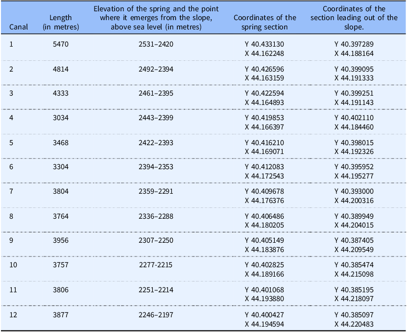

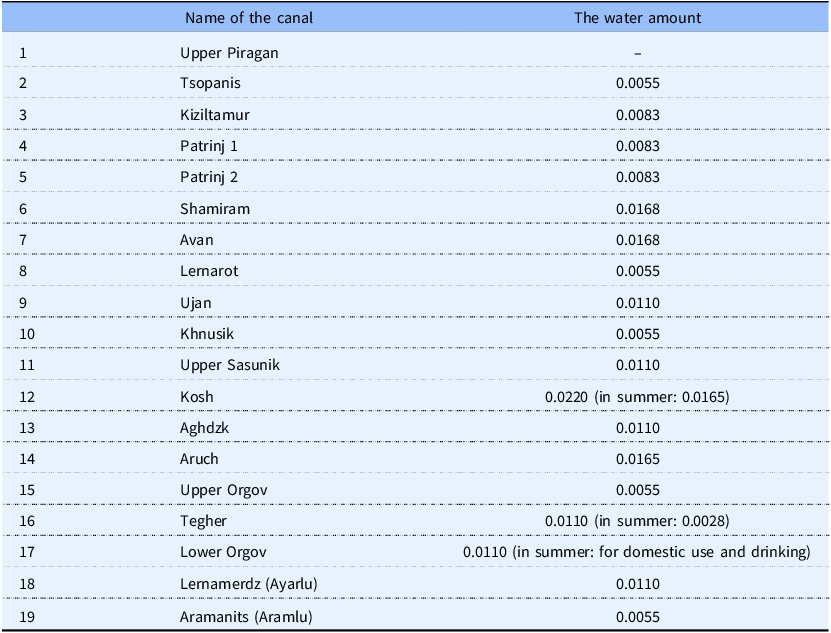
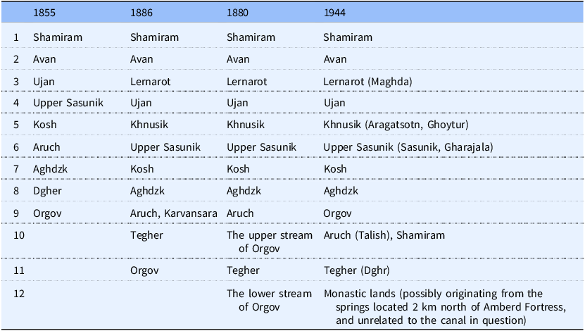
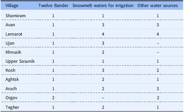
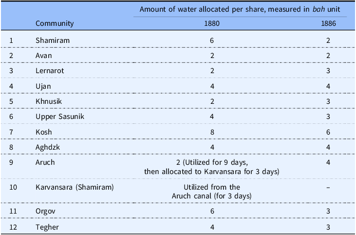


 Open access

