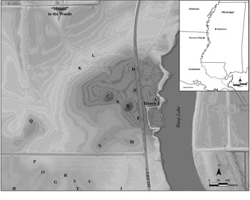
This article presents the results of recent research at Jaketown (22HU505), a Native American earthwork site in the Lower Yazoo Basin of west-central Mississippi (Figure 1). Evidence from Jaketown comprises a significant part of the material record attributed to the Poverty Point culture. As a culture-historical unit, Poverty Point is used to describe groups living in the Lower Mississippi Valley during the Late Archaic period (ca. 5800–3000 BP; Byrd Reference Byrd1991; Ford and Webb Reference Ford and Webb1956; Gibson Reference Gibson2000; Jackson Reference Jackson1989, Reference Jackson and Gregg1991; Kidder Reference Kidder and Pauketat2012; Lehmann Reference Lehmann and Byrd1991; Phillips Reference Phillips1970; Phillips et al. Reference Phillips, Ford and Griffin1951; Sassaman Reference Sassaman2005; Sassaman and Brooks Reference Sassaman and Brooks2017; Webb Reference Webb1968, Reference Webb1982). The culture is named after the Poverty Point site (16WC5), a landscape of earthen mounds, ridges, and other features covering over 5 km of Macon Ridge in the Upper Tensas Basin of Louisiana, approximately 100 km southwest of Jaketown. Unique for its region and period, the Poverty Point site has attracted considerable anthropological attention as a perceived contradiction of once-orthodox models of cultural evolution. Living in a subtropical alluvial environment, the people of Poverty Point maintained social structures responsible for complex architecture and exchange systems unrivaled in scale and elaboration for millennia in eastern North America. According to available data, they did so without domesticate-based agriculture or institutionalized social hierarchy (Gibson Reference Gibson2007; Jackson Reference Jackson1989; Kidder Reference Kidder, Sassaman and Holley2011; Ward Reference Ward1998).
Map of the Jaketown site, with locations of mounds (A, B, C, D, E, F, G, H, I, P, Q, S, V, and X), artifact scatters (K, L, M, N, O, R, and T), and other areas discussed in the text. Inset map of the Lower Mississippi Valley of the southeastern United States, with the locations of the Jaketown and Poverty Point sites. (Base map courtesy of Kelly Ervin.)

To understand the sociopolitical processes responsible for Poverty Point, archaeologists have turned to contemporary sites in the Lower Mississippi Valley and identified variation in chronology, material culture, and degree of landscape modification (Ford et al. Reference Ford, Phillips and Haag1955; Phillips et al. Reference Phillips, Ford and Griffin1951; Sassaman and Brooks Reference Sassaman and Brooks2017; Saunders and Allen Reference Saunders and Allen2003; Webb Reference Webb1968, Reference Webb1982). Jaketown is the largest of these contemporary sites. Drawing on recently recovered data, we suggest that variation in chronology and cultural practices between Poverty Point and Jaketown offers a stereoscopic view of social change in the Lower Mississippi Valley. As remains of shared practices, elements of “Poverty Point culture” exist at both places. But only in abstract do these elements come to represent the defined set of practices or shared system of social organization implied by culture-historical frameworks.
Our empirical findings at Jaketown support a broader methodological position: the multiscalar nature of social organization in the Late Archaic Lower Mississippi Valley—characterized by extensive social networks and diverse localized practices—demands closer attention to geographically dispersed and temporally staggered dynamics of social change. At Jaketown, we identify these dynamics in the following sequence of events. First, people came to the naturally elevated ridges of a point bar along an inactive channel of the Mississippi River at Jaketown around 4525–4100 cal BP (95.4% confidence interval; Table 1) and left behind distinctive clay artifacts known as Poverty Point Objects (PPOs), lithic debitage from nonlocal sources, and food remains. Second, around 3450–3350 cal BP (95.4% confidence interval), well after initial use, people intensively occupied the site, participated in lithic exchange networks, and engaged in patterns of wild-plant harvesting, processing, and consumption distinct from those observed at contemporary sites. Third, the community at Jaketown constructed extensive earthworks and post structures around 3445–3270 cal BP (95.4% confidence interval), before the apex of construction at Poverty Point. Fourth, catastrophic flooding caused by shifts in the course of the Mississippi River sometime between approximately 3300 cal BP and roughly 2780 cal BP buried most of the built landscape under alluvium (Kidder Reference Kidder2006; Kidder et al. Reference Kidder, Henry and Arco2018:Table 1) and ended Late Archaic use of the site. These site-level findings depict the history of Late Archaic Jaketown as an amalgamation of continued practice and novel events occurring over a long period of time. They support neither the adoption of a unified suite of traits particular to the Poverty Point site nor a historical trajectory aligned with a homogenous regional chronology.
Radiocarbon Dates from Jaketown.

a Radiocarbon dates are reported as Radiocarbon Years Before Present and calculated using the Libby 14C half-life (5,568 years).
b Dates calibrated using OxCal v4.4 (Bronk Ramsey Reference Bronk Ramsey2020) using the IntCal20 dataset (Reimer et al. Reference Reimer, Austin, Bard, Bayliss, Blackwell, Ramsey and Butzin2020).
c Radiocarbon results from Woods Hole NOSAMS were corrected for isotopic fractionation using unreported δ13C values measured on the accelerator.
Defining Poverty Point: A Unified Culture?
Historically, archaeologists have described Poverty Point as a unified culture with its origins at the Poverty Point site (Byrd Reference Byrd1991; Ford et al.Reference Ford, Phillips and Haag1955; Gibson Reference Gibson2000:268–274, Reference Gibson2007; Haag and Webb Reference Haag and Webb1953; Jackson Reference Jackson and Gregg1991; Lehmann Reference Lehmann1982; Webb Reference Webb1968). Following the conventions of culture history, sites are classified as “Poverty Point sites” based on evidence for one or more characteristic traits. These include the presence of PPOs, assemblages of lithic material imported from other regions, and, less often, earthworks (Ford and Webb Reference Ford and Webb1956; Webb Reference Webb1968, Reference Webb1982; Williams and Brain Reference Williams and Brain1983). A close reading of available data, however, imparts a different view. It is difficult to discern a temporally and geographically distinct, technologically uniform culture—or set of material practices, social structures, and worldviews that distinguishes one group of people from another—in the archaeological record of the Late Archaic Lower Mississippi Valley. Poverty Point–associated traits are widely distributed (Webb Reference Webb1968, Reference Webb1982:5–9), and we know little about the temporal relationships between most sites. Sites vary significantly in size (Webb Reference Webb1982:9), and earthworks are present at only a small fraction (Gibson Reference Gibson and Rees2010:80). Not all Poverty Point sites share all (or even many) of the settlement or material characteristics of the type community (Webb Reference Webb1982:Table 18). Some traits used to define Poverty Point culture have considerable temporal duration and, for this reason, are not relevant to reconstructing short-term dynamics of social change. This is especially true of PPOs, which are similar to artifacts used in preceding and subsequent periods in the region and beyond (Ford et al. Reference Ford, Phillips and Haag1955:52–53; Henry et al. Reference Henry, Ortmann, Arco and Kidder2017; Saunders et al. Reference Saunders, Jones, Moorhead and Davis1998). Taking all of this into consideration, we conclude that assemblages of PPOs, nonlocal lithics, earthworks, and other traits do not form a strong basis for building a regional typology. Instead, these features are most analytically useful when understood as archaeological manifestations of contingent events nested within larger historical processes.
This observation is informed by two sources: studies of hunter-gatherer sociopolitical variability and relational taxonomies derived from Native American philosophy. Regarding the former, culture-historical units implicitly assume a degree of geographical uniformity and temporal continuity. This in turn obscures a key feature of many hunter-gatherer societies: social structures that vary along lines of hierarchy and group size according to seasonal as well as episodic dynamics of production, settlement, and exchange (Wengrow and Graeber Reference Wengrow and Graeber2015). We identify comparable variation in aspects of Poverty Point culture as described above: smaller sites with fewer diagnostic traits contrast with large sites of aggregation and more codified practice. This poorly understood social pattern likely formed in dialogue with ecological systems and is therefore analytically linked to notions of place and human–nonhuman relatedness embodied in Native monumental landscapes across the Southeast (Bloch Reference Bloch2019, Reference Bloch2020; Howe Reference Howe2014; Sanger Reference Sanger2021). Culture-historical frameworks cannot help us understand what they are not designed to see, whether that be radically flexible social structures or—following Zedeño (Reference Zedeño2009)—permeable boundaries between humans and nonhumans.
To escape the implicit assumptions and blind spots of culture history, Feinman and Neitzel (Reference Feinman and Neitzel2020:9) recommend that archaeologists describe sites and artifacts according to “the presence/absence or frequency of specific features . . . accompanied by available absolute date ranges rather than period or phase distinctions.” Accordingly, rather than the greatest concentrations of traits used to define Poverty Point culture, we describe Poverty Point and Jaketown as the first and second largest sites (by spatial extent) in the Lower Mississippi Valley between approximately 5800 and 3000 BP. Our data indicate significant variation in the presence, absence, and frequency of certain features, including forms of architecture, material culture, and emphasis on particular plants. We suggest that focusing on this variation opens new analytical pathways by which to understand processes of social and environmental change.
Jaketown: Site Description and Previous Research
The Jaketown site occupies more than 80 ha of a relict Mississippi River point bar adjacent to an oxbow known as Wasp Lake. Material culture from the Middle Archaic (8000–5800 BP) through the historic era is present, but the Late Archaic component comprises the most intensive occupation based on volume and spatial extent of associated artifact scatters, earthworks, and midden (Ford et al. Reference Ford, Phillips and Haag1955:104; Haag and Webb Reference Haag and Webb1953; Lehmann Reference Lehmann1982:5; Phillips Reference Phillips1970:404). When Jaketown was first surveyed in the 1940s, Phillips recorded six earthen mounds, labeled A–F (Phillips et al. Reference Phillips, Ford and Griffin1951:Figure 43). Of these, only Mounds B and C are prominent on the landscape today. A paleochannel of the Stage 3 Mississippi River arcs across the site west of Mounds B, C, D, and E (Ford et al. Reference Ford, Phillips and Haag1955:18–24; Saucier Reference Saucier1994). Roughly 500 m to the southwest of Mound B on a levee forming the western edge of the relict channel, Ford and colleagues (Reference Ford, Phillips and Haag1955) located at least seven low, dome-shaped mounds during extensive survey and excavations in 1951. The largest of these, Mound G, was partially excavated and determined to be anthropogenic based on the presence of material culture and features. No radiocarbon samples were collected, but the material culture assemblage was very similar to that of the Poverty Point site, lacking ceramics but dominated by PPOs and nonlocal lithic tools and debitage (Ford et al. Reference Ford, Phillips and Haag1955:36–37). Ford and colleagues classified an additional series of low rises and artifact scatters along the levee as “locations” (Ford et al. Reference Ford, Phillips and Haag1955:Plate 1). None of the levee mounds or locations are distinct on the landscape today. Artifact assemblages similar to the Mound G assemblage—PPOs, lithic tools, debitage, Late Archaic projectile points, and very few ceramics—were recovered from the surface of the whole area of the levee mound and location group (Lehmann Reference Lehmann1982). Across the paleochannel to the northwest of Mound C, Ford and colleagues (Reference Ford, Phillips and Haag1955:Figure 5) identified and mapped a Y-shaped earthen rise. Labeled “Mound in the Woods,” the feature has been significantly altered by modern ditch digging and the construction of a large pond, but it is still clearly visible.
Following these initial investigations, researchers returned to Jaketown to conduct analyses of privately held surface collections and obtain radiocarbon dates from core samples (Lehmann Reference Lehmann1982; Saunders and Allen Reference Saunders and Allen2003). Despite this work, a lack of reliable chronometric data and differing stratigraphic analyses led to multiple equivocal interpretations of the cultural, ecological, and geomorphologic history of the site (Ford et al. Reference Ford, Phillips and Haag1955:104–117; Phillips Reference Phillips1970:528; Saunders and Allen Reference Saunders and Allen2003:162–163; Williams and Brain Reference Williams and Brain1983:354).
Methods
This article is based on the findings of several seasons of fieldwork conducted at Jaketown from 2007 to 2009 and from 2018 to 2020. Our research objectives were to (1) determine the geomorphology and paleoecology of the Late Archaic component; (2) gather new data to establish a secure chronology and better understanding of stratigraphic sequences, especially of the Late Archaic earthworks; and (3) recover and document paleoethnobotanical samples. Sediment coring conducted at the site in 2009 identified a deeply buried Late Archaic deposit between Mounds B and C. Following coring, a team from Washington University in St. Louis and Murray State University excavated a 2 × 2 m unit into the deposit and identified it as an earthwork, labeled Mound X. An additional 1 × 2 m unit was placed immediately south of Mound A, and a stepped 4 × 1 m unit was placed in a drainage cut bisecting Mound in the Woods. The rest of our data were recovered by reopening extensive trenches that Ford and colleagues excavated in 1951.
We used multiple field and laboratory methods to build a holistic dataset. Field analysis included standard stratigraphic description, systematized soil sampling, and artifact recovery by screen (6.35 mm [¼-in.] mesh) and hand excavation. We collected carbonized seeds and nutshell from contexts of interest for radiocarbon dating. We calibrated our results using OxCal v4.4 (Bronk Ramsey Reference Bronk Ramsey2020) and the IntCal20 calibration curve (Reimer et al. Reference Reimer, Austin, Bard, Bayliss, Blackwell, Ramsey and Butzin2020). Column samples collected from excavation units were analyzed in the Geoarchaeology Laboratory at Washington University in St. Louis, and they were subject to particle-size analysis, magnetic susceptibility, and micromorphological analysis of sediment thin sections. We collected flotation samples systematically by context during new excavations and from earthwork and midden contexts identified in exposed profiles in reexcavations. Samples were processed in a modified SMAP-style flotation tank. Heavy and light fractions were both recovered to 0.425 mm. Macrobotanical analysis was conducted in the Paleoethnobotany Laboratory at Washington University in St. Louis.
We chose to reexcavate rather than open new units in 2018 and 2019 in consideration of both the significant depth below ground surface of the Poverty Point component (roughly 3.5 m in parts of the site) and the persistent cultural significance of Jaketown. Regarding the latter, we prioritized the preservation of Jaketown's remaining earthworks in light of Native American critiques of archaeological practice (e.g., Atalay Reference Atalay2006; Wilson Reference Wilson2008). Furthermore, previous excavators encountered numerous burials at Jaketown, likely associated with the late precontact- and historic-era components (Ford et al. Reference Ford, Phillips and Haag1955:32). New extensive excavations would potentially disturb any burials remaining at the site. We recommend this strategy of reexcavation to other researchers working in culturally significant landscapes with histories of prior archaeological excavation.
Late Archaic Jaketown
Paleotopography and Ecology
The paleotopography of Late Archaic Jaketown is largely obscured by subsequent alluviation. Core data confirm the Mississippi River paleochannel in the western portion of the site documented by Ford and colleagues (Reference Ford, Phillips and Haag1955:18–24) and show that at least four natural swales and five sandy point-bar ridges underlie the modern surface of Jaketown. Some sections of the point bar ridges show evidence of an A horizon forming before initial cultural deposits, indicating that the sandy surfaces of the point bars were covered in vegetation before people used them.
Although some Middle Archaic material culture is present at Jaketown (Lehmann Reference Lehmann1982), there is no evidence of extensive site use prior to the Late Archaic. Researchers have offered various hypotheses regarding the interface of the point bars and initial Late Archaic cultural strata. Ford and colleagues (Reference Ford, Phillips and Haag1955:33:Figure 9) observed a sequence of stratified deposits containing PPOs, lithic debitage, and charcoal interleaved with clean loamy sediments overlying the point bar in a trench excavated into Mound A. Ford interpreted the loamy sediments as natural alluvial deposits, suggesting that the Stage 3 Mississippi River channel immediately east of the site—which became Wasp Lake—was active when people using Poverty Point–associated material culture first occupied Jaketown. Following Ford, the stratified deposits were interpreted as temporary encampments left behind by mobile hunter-gatherer groups who came and went according to the state of the river (Connaway et al. Reference Connaway, McGahey and Webb1977:91–93; Ford et al. Reference Ford, Phillips and Haag1955:22).
Phillips (Reference Phillips1970:527–529) later hypothesized that these loamy sediments were in fact cultural deposits associated with the construction of an earthwork. Our research corroborates this interpretation (discussed below). The cultural origin of the loamy sediments and lack of active levee building or other significant sedimentation indicates that the Stage 3 channel was most likely only a small underfit stream during the Late Archaic occupation. A recently formed oxbow lake was located west of the site, fostering a range of aquatic species. In this respect, Jaketown resembles the majority of other Late Archaic sites in the region, also located along the geomorphologically stable and resource-rich backwaters of the Mississippi River floodplain (Jackson Reference Jackson1989; Webb Reference Webb1982).
Early Site Use
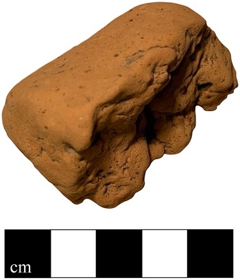
A pit cut directly into the point bar beneath Mound A represents the first known use of the site by people during the Late Archaic. A persimmon (Diospyros virginiana) seed recovered from the pit dates to 4525–4100 cal years BP (95.4% confidence interval). The sample was directly associated with a biconical PPO (Figure 2), fragments of baked clay, small pieces of unidentified fish and mammal bone, and what appears to be processed fruit pulp—likely persimmon. Lithic fragments were also recovered from the pit fill, including microflakes of novaculite (likely sourced from west-central Arkansas; Gibson Reference Gibson, Baugh and Ericson1994; Lehmann Reference Lehmann and Byrd1991). A flotation sample from the pit contained fragments of persimmon seeds, acorn (Quercus sp.) and hickory (Carya sp.) nutshell, and a small number of chenopod (Chenopodium sp.) seeds.
Biconical PPO collected from pit dug into point bar beneath Mound A. (Color online)

The presence of a biconical PPO and nonlocal lithic material in this early context is notable. Baked clay objects of varying morphologies were used during the Middle Archaic west of the Mississippi (Hays et al. Reference Hays, Weinstein and Stoltman2016; Saunders et al. Reference Saunders, Jones, Moorhead and Davis1998; Webb Reference Webb1982), but biconical clay objects are one of the common morphologies identified in large numbers at Poverty Point and during later phases at Jaketown (Ford et al. Reference Ford, Phillips and Haag1955:Table 2; Webb Reference Webb1982:Table 4). For the purposes of our study, we emphasize that PPOs found in combination with nonlocal lithics are among the most common traits used by researchers to identify Poverty Point–associated sites (Gibson Reference Gibson2007; Webb Reference Webb1982). As cooking tools, PPOs indicate a particular culinary practice with deep and varied roots (Hays et al. Reference Hays, Weinstein and Stoltman2016; Saunders et al. Reference Saunders, Jones, Moorhead and Davis1998), whereas nonlocal lithics indicate long-distance social relationships (Gibson Reference Gibson, Baugh and Ericson1994; Jackson Reference Jackson and Gregg1991; Sassaman Reference Sassaman2005). Taken together, these artifacts suggest that the people who left behind this early pit were already familiar with practices that came to characterize life at both Jaketown and Poverty Point during later periods. Micromorphological analysis indicates that an incipient A horizon developed over the pit after it was filled in. For this horizon to form, the landscape must have been stable and undisturbed—at least in this area of the site—for an extended period of time after the infilling of the pit and before the construction of Mound A began around 3445 cal BP.
Intensive Occupation and Earthwork Construction
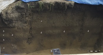
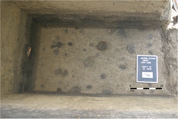
People intensively occupied Jaketown around roughly 3450 to 3350 cal BP (95.4% confidence interval), leaving behind midden and sequences of post molds near the western bank of Wasp Lake. This community harvested the same plants as the group represented by the early pit described above—again, acorn, hickory, and persimmon were the dominant taxa identified in flotation samples taken from midden contexts. When Ford's team first encountered the midden, they noted organically rich deposits containing Poverty Point material culture and post molds—including a sequence in a circular formation—beneath what they described as a stratum of natural levee sediments (Reference Ford, Phillips and Haag1955:31, Figure 8). When our team reopened this context for geoarchaeological and paleoethnobotanical sampling in 2019, we encountered two layers of midden and a sequence of four evenly spaced post molds 20–30 cm in diameter and roughly 50 cm apart (Figure 3). Based on nearly identical dimensions and stratigraphy, we interpret these post molds as part of the circular formation noted by Ford. We also observed many smaller post molds in our 1 × 2 m unit abutting Ford's original excavations, but we could discern no configurations (Figure 4).
North profile of Trench 1: (a) natural point bar, (b) midden, (c) silty clay fill, (d) post molds, and (e) alluvium. (Color online)

Floor of excavation unit adjacent to Trench 1 showing post molds in point bar beneath Poverty Point–era midden. (Color online)

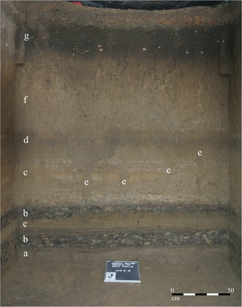
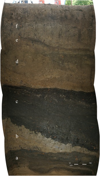
In addition to Mound G as described by Ford and colleagues (Reference Ford, Phillips and Haag1955:36–37), our research identifies Mounds A and X as Late Archaic earthworks, likely built simultaneously or in short succession between 3445 and 3270 cal BP (95.4% confidence interval). People constructed both earthworks by layering organically and culturally enriched sediments and silty clays, resulting in distinct stratiform deposits (Figures 5 and 6). The layers of enriched fill contain a mixture of PPOs, lithic debris, acorn, hickory nutshell, and persimmon and chenopod seeds, resembling the composition of samples from the early pit beneath Mound A and the midden along Wasp Lake. We collected diagnostic Poverty Point–associated material culture from the enriched fill in Mound X, including a Pontchartrain point and steatite vessel fragment. We observed no occupation surfaces, significant weathering, or natural soil formation between layers of construction fill in either earthwork, indicating that builders worked relatively rapidly, leaving no layers exposed for long.
South profile of excavation unit in Mound A: (a) natural point bar, (b) organically and culturally enriched fill, (c) silty clay fill, (d) earthwork surface, (e) post molds, (f) alluvium, and (g) late precontact midden. (Color online)

East profile of excavation unit in Mound X: (a) submound surfaces, (b) clay fill, (c) organically and culturally enriched fill, (d) silty clay fill, (e) earthwork surface, and (f) alluvium. (Color online)

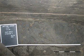
Successive surfaces directly underlying Mound X represent at least two events resulting in a rich mixture of plant and animal remains and PPOs. These surfaces included multiple concentrations of PPOs and an intact combustion feature. We also observed an assemblage of mammalian long bones (likely deer) oriented in a manner that suggests deposition in a single event (Figure 7). Flotation samples from the PPO concentrations contain persimmon, hickory, acorn, and chenopod. Due to massive rainfall shortly after we uncovered the deposits, we were unable to collect faunal material beyond small fragments and unidentified fish bones captured in flotation samples. Micromorphological analysis of the interface of the surfaces and initial layer of mound fill shows no evidence of weathering, which means that deposition events occurred in quick succession. To our knowledge, there are no comparable deposits directly underlying a Late Archaic earthwork described elsewhere in the Lower Mississippi Valley, although the deposits do resemble submound floors observed at the Middle Archaic Frenchman's Bend site in northeast Louisiana (Saunders Reference Saunders, Gibson and Carr2004:152–153). At Jaketown, we interpret these layers as the remains of communal gathering and feasting activities associated with the subsequent construction of Mound X. We discuss this interpretation in more detail below.
Sub–Mound X surface with animal bones, PPOs, and charred plant remains. (Color online)

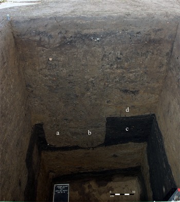
Although we cannot unequivocally interpret how Mounds A and X were used once completed, we do have evidence of some events occurring after or toward the end of construction. An area of red hardened earth with high magnetic susceptibility values near the top of Mound A indicates that a fire was built on the surface at some point, although we found no associated charcoal. People inserted posts into both mounds during or after construction. Post molds roughly 60 cm in diameter—the largest observed at Jaketown—were placed in Mound X, originating at the surface and extending down through multiple layers of fill (Figure 8). Ford and colleagues (Reference Ford, Phillips and Haag1955:34, Figure 10) noted small post molds originating within and running through layers of fill in Mound A, forming a curvilinear outline in one instance. These posts appear to be considerably smaller than the posts in the circular formation associated with the midden by Wasp Lake described above.
North profile of excavation unit in Mound X: (a and b) two adjacent post molds running through (c) organically and culturally enriched fill and (d) silty clay fill. (Color online)

Other Aspects of the Poverty Point–Era Landscape
The low mounds and locations observed by Phillips and colleagues (Reference Phillips, Ford and Griffin1951) and Ford and colleagues (Reference Ford, Phillips and Haag1955) along the western edge of the site have not been radiocarbon dated, making it difficult to associate these areas with the activities at Mounds A and X and along Wasp Lake, although most of the material culture recovered from the areas was Late Archaic. Similarly, although Mound G is definitively considered a Late Archaic earthwork, the lack of absolute dating prevents us from including it in a refined site chronology. The role of Mound in the Woods during the Late Archaic occupation also remains ambiguous. Coring and excavations conducted in 2020 suggest that the rise is a remnant of a larger natural feature serendipitously protected from alluvial erosion. However, we posit that Poverty Point–era people incorporated Mound in the Woods into the cultural landscape at Jaketown. Evidence for such use include its prominence (it is the highest natural feature in the immediate area) and the density of Poverty Point material culture on the “mound” surface observed in recent surveys.
Flooding
Sometime after 3300 cal BP, global climate change caused increased precipitation over the North American midcontinent. The Mississippi River accommodated the resulting higher flow by shifting course, moving from Stage 2 to Stage 1 of the Mississippi River system (Kidder Reference Kidder2006; Kidder et al. Reference Kidder, Adelsberger, Arco and Schilling2008; Saucier Reference Saucier1994). At Jaketown, and across much of the Lower Mississippi Valley, this stage shift caused catastrophic flooding. The higher flow inundated the backwater channel that is now Wasp Lake, breaching the levee just north of Mound A and flooding much of the site. The Late Archaic landscape—including Mounds A and X—was buried under alluvium (Kidder et al. Reference Kidder, Henry and Arco2018). This period represents a large-scale reordering of life throughout the Mississippi Valley (Kidder Reference Kidder2006).
Defining Poverty Point: The View from Jaketown
Informed by our interpretation of events at Jaketown between roughly 4500 and 3300 cal BP, we return to the nature of the relationship between Jaketown and the Poverty Point site and the analytic utility of Poverty Point as an archaeological culture. Considering both chronology and significant similarities in material culture, we are confident that the communities at Jaketown knew of and—considering hunter-gatherer sociopolitical variability—perhaps partially comprised the communities responsible for building Poverty Point. We follow Sassaman's (Reference Sassaman2005) analysis of the social geography of Poverty Point as corporate and pluralistic, and Spivey and colleagues’ (Reference Spivey, Kidder, Ortmann, Arco, Gilmore and O'Donoughue2015) interpretation of Poverty Point as a place of pilgrimage to situate Jaketown as an associated site of both localized and integrative practice. Accordingly, people at Jaketown inhabited and constructed the local environment, social history, and cultural meaning of the site while simultaneously participating in the social phenomena responsible for the earthworks at Poverty Point. Comparisons of evidence for exchange, aggregation, architectural innovation, and specialized plant use clarify the significance of intersite variability for understanding social developments in the Late Archaic Lower Mississippi Valley.
Artifacts of Exchange and Aggregation
The biconical PPO and nonlocal lithics left behind in the pit beneath Mound A at Jaketown are currently the earliest manifestations of traits used to define Poverty Point culture. They appeared at Jaketown nearly 500 years before the substantial use of similar artifacts at Poverty Point. In later phases, however, artifact assemblages from Jaketown and Poverty Point are qualitatively similar, sharing many stylistic and functional features (Webb Reference Webb1982:70–71). People at both sites crafted characteristic multiform PPOs and maintained a distinctive microlithic and lapidary industry focused on the production of blades, drills, and beads from mostly nonlocal raw material. The quantity and array of nonlocal material present early at Jaketown—including novaculite and steatite (sourced from the Southern Appalachians)—indicate that the Late Archaic community was engaged in nonlocal exchange networks before the apex of activity at Poverty Point (Johnson Reference Johnson1993; Lehmann Reference Lehmann and Byrd1991).
As stated above, the organically rich surfaces under Mound X may represent communal feasting, perhaps held in the fall given the predominance of persimmon (ripe from September to November across much of the Southeast today). The density of food remains observed and “eventfulness” of the deposition under Mound X are consistent with archaeological signatures of feasting (Kassabaum Reference Kassabaum2019; Peres Reference Peres2017; Twiss Reference Twiss2012). This event or events could be related to the gatherings described as a potential driver of the construction of Poverty Point (Hays Reference Hays2018; Spivey et al. Reference Spivey, Kidder, Ortmann, Arco, Gilmore and O'Donoughue2015) or might represent a distinct practice. We need more data to draw further conclusions, but the similarity of the sub–Mound X feasting deposit to assemblages of food remains and material culture from earlier contexts at the site suggest sustained, localized foodways focused on group food processing and shared meals.
Architecture
Although we do not know the full extent or form of the earthworks at Jaketown, geoarchaeological data discussed above demonstrate that both Mounds A and X were constructed rapidly, comparable to the construction of Mound A and the ridges at Poverty Point (Kidder et al. Reference Kidder, Kai, Henry, Grooms and Ervin2021; Ortmann and Kidder Reference Ortmann and Kidder2013). This suggests similar methods of construction at the two sites, at least in terms of the pace of labor. Whereas a number of construction methods are evident at Poverty Point (Kidder et al. Reference Kidder, Ortmann and Allen2004; Ortmann and Kidder Reference Ortmann and Kidder2013), at Jaketown so far we have evidence for only the stratified method used to build Mounds A and X. The association between posts and earthworks is a potentially more significant point of architectural variation between the two sites. The large posts erected during or after the construction of Mounds A and X are similar to those observed in the plaza of Poverty Point, but there is no evidence of posts being placed in earthworks at a similar scale at Poverty Point (Hargrave et al. Reference Hargrave, Berle Clay, Dalan and Greenlee2021; Kidder et al. Reference Kidder, Kai, Henry, Grooms and Ervin2021; Ortmann and Kidder Reference Ortmann and Kidder2013). This suggests shared (although not identical) architectural practices in terms of form and ultimate function. The use of posts at both sites may be temporally differentiated, although we cannot say this conclusively. The post circles at Poverty Point were in use during early and peak phases of earthwork construction at Poverty Point (Hargrave et al. Reference Hargrave, Berle Clay, Dalan and Greenlee2021). The posts at Jaketown are in diverse contexts that span at least the period of earthwork construction. Without more chronometric data from both sites, we cannot prove or disprove that the post circles at Poverty Point were contemporaneous with the posts at Jaketown. Although the generally earlier chronology at Jaketown suggests that the community there might have built post circles before the practice was brought to Poverty Point, the ambiguous chronology of plaza construction at Poverty Point limits further conclusions. The smaller post molds noted in association with the midden by Wasp Lake are the only ones of their kind that are well documented at a Poverty Point–associated site. If these represent domestic or utilitarian structures, they carry significant implications for our understanding of mobility and seasonality. Alternatively, given that we know little about Late Archaic monumentality in general, the smaller post configurations could be part of landscape modification practices not yet recognized in the archaeological literature.
Currently available data indicate that the construction of Mounds A and X at Jaketown preceded the construction of the ridges and Mound A at Poverty Point by several generations. Building on this temporal difference, Lee Arco speculated that the arcuate point-bar landscape of Late Archaic Jaketown formed the plan for the ridges at Poverty Point (Kidder Reference Kidder, Sassaman and Holley2011). The two sites are mirror images of one another, and the earlier dates at Jaketown could indicate that an architectural plan imported from Jaketown was used to guide the radical reconfiguration of Poverty Point after approximately 3400 cal BP (Kidder Reference Kidder, Sassaman and Holley2011, Reference Kidder and Pauketat2012). More chronometric data will elucidate the nature of this recursive—possibly ancestral—relationship. The intentional repetition of architectural layouts at different sites would not be unprecedented. We draw attention to the recapitulation of the architecture of the Anna site at the Emerald Mounds site in the Natchez Bluffs of Mississippi, as well as the concept of “moving mounds” recorded in Bloch's ethnographic work with a modern Native American community in the Lower Mississippi Valley (Bloch Reference Bloch2020:529). In the latter example, Bloch's interlocutor describes practices of transporting whole earthworks to new locations, reinforcing the connection between earthworks and theories of landscape animacy present in Native American philosophy (Miller Reference Miller2015; Watts Reference Watts2013; Zedeño Reference Zedeño2009).
Beyond the Lower Mississippi Valley, communities on the Atlantic Coast also built circular features and erected monumental posts during the Late Archaic (Russo and Heide Reference Russo and Heide2001; Sanger Reference Sanger2021). Furthermore, Middle Archaic earthwork complexes have been identified throughout the Lower Mississippi Valley (Saunders et al. Reference Saunders, Mandel, Garth Sampson, Allen, Thurman Allen, Bush and Feathers2005), and earthwork construction continued in the region—and, indeed, at Jaketown—through the historic era (Ford et al. Reference Ford, Phillips and Haag1955; Phillips et al. Reference Phillips, Ford and Griffin1951). The extent and diversity of landscape modification in eastern North America is another factor that complicates the delineation of Poverty Point culture as a distinct, exclusive unit of practices. To avoid the issue, the earthworks at Jaketown and Poverty Point should instead be understood as individual, historically particular manifestations of an enduring and diffuse architectural tradition.
Plant Use
Although only three Poverty Point–associated sites have been subject to significant paleoethnobotanical research, differences in plant use across sites suggest a dynamic of localized variation and persistent shared traditions similar to that observed in the architectural record. Paleoethnobotanical assemblages from contexts sampled thus far at Jaketown document a focus on persimmon and chenopod not present at Poverty Point (Ward Reference Ward1998) or the nearby J. W. Copes site (16MA47; Jackson Reference Jackson1989). Although nearly ubiquitous at Jaketown, persimmon is present in less than a quarter of the contexts sampled at Poverty Point and J. W. Copes; chenopod is comparably hyper-represented at Jaketown (Figure 9). Rather than reflecting variation in resource availability alone, we consider the contrasts in plant use to indicate different methods of gathering, processing, and consuming wild foods. Considering the centrality of foodways to cultural identity and processes of social differentiation (Twiss Reference Twiss2012), the emphasis on persimmon at Jaketown is significant. The charred conglomerate of fruit pulp recovered from the pit beneath Mound A bears similarities to the persimmon bread—made by baking or drying long loaves of strained pulp—central to Native American cuisine in the Lower Mississippi Valley during the historic era (Swanton Reference Swanton1911:77).
Percent ubiquity of taxa in flotation samples analyzed from Jaketown, Poverty Point (Ward Reference Ward1998:Figures 1 and 4) and J. W. Copes (Jackson Reference Jackson1989:Table 1).

At Jaketown, Poverty Point, and J. W. Copes, people conserved wild food harvesting practices despite exchange connections to regions where communities were growing domesticated members of the Eastern Agricultural Complex, including goosefoot (Chenopodium berlandieri var. jonesianum), marsh elder (Iva annua), and sunflower (Helianthus annuus). By approximately 3400 years BP, these regions of early domestication overlapped with multiple source areas for lithics found at Poverty Point, Jaketown, and J. W. Copes, including Arkansas (the source of novaculite), the Ohio River valley (Gray Northern Flint), southeastern Missouri (galena), and the Tennessee River Valley (Fort Payne, Pickwick, and Dover chert; Gibson Reference Gibson, Baugh and Ericson1994:Figure 1; Lehman Reference Lehmann and Byrd1991; Smith Reference Smith2011:Figure 1; Walthall et al. Reference Walthall, Webb, Stow and Goad1982). The lack of domesticated chenopod or other Eastern Agricultural Complex crops at Jaketown, Poverty Point, and J. W. Copes1 suggests that communities maintained a mode of food production distinct from practices known within their larger social network. This distinction could be the result of ritual rules restricting consumption to particular foods adhered to by visitors during aggregation events, comparable to situational or ideological food taboos documented in other cultures (Twiss Reference Twiss2012). Later residents of the Lower Mississippi Valley continued to emphasize wild plant gathering over the adoption of Eastern Agricultural Complex crops—despite social connections to agricultural regions—until shortly before European contact (Fritz Reference Fritz, Denham, Iriarte and Vrydaghs2007; Fritz and Kidder Reference Fritz and Kidder1993).
Although seeds in the Jaketown chenopod assemblage do not exhibit markers of domestication—mainly a significantly reduced seed coat—there is variation in seed morphology. Further morphometric analysis is ongoing. Managed or not, chenopod is a disturbance taxa—a plant that grows best in newly overturned soil—and its inclusion in archaeological contexts can indicate either alluvial or anthropogenic soil disturbance around the site at the time of deposition. This fits the contexts in which chenopod has been identified at Jaketown, including pit fill, middens, and deposits associated with earthwork construction. The plant may have thrived in the regularly disturbed earth of Jaketown's anthropogenic landscape, and, considering its edible greens and starchy seeds, people may have let it grow while clearing other species. This form of relationship, characterized by regular interaction but not necessarily domestication, remained a key aspect of peoples’ relationships with plants in the Lower Mississippi Valley for millennia (Fritz Reference Fritz, Denham, Iriarte and Vrydaghs2007). It also closely resembles the people–plant relationships characteristic of certain eras in Amazonia—another region known for social variability and multipolar social structures (Fausto and Neves Reference Fausto and Neves2018; Heckenberger et al. Reference Heckenberger, Christian Russell, Fausto, Toney, Schmidt, Pereira, Franchetto and Kuikuro2008).
Conclusion
As noted by generations of anthropologists and archaeologists (e.g., Brain Reference Brain, Dunell and Hall1978; Feinman and Neitzel Reference Feinman and Neitzel2020; Holland-Lulewicz Reference Holland-Lulewicz2021; Mauss Reference Mauss and Schlanger2006; Wolf Reference Wolf1984), culture histories and similar heuristics are only useful insofar as they help explain real social processes. Following this logic, we find that the Poverty Point culture-historical unit fails to explain—and indeed obscures—prominent social processes observed in the archaeological records of Jaketown and Poverty Point, including the maintenance of long-term exchange relationships and differential, selective engagement with shared architectural traditions and foodways. These facets of Poverty Point culture—extralocal signatures and diverse practices across sites—have long been recognized by researchers working in the region (Gibson Reference Gibson, Baugh and Ericson1994, Reference Gibson2000; Phillips et al. Reference Phillips, Ford and Griffin1951; Webb Reference Webb1982). However, the strictures imposed by the culture historical unit itself have obscured the full significance of the societies of the Late Archaic Lower Mississippi Valley to the broader scope of hunter-gatherer social theory and North American history. Poverty Point is often described as unprecedented in terms of scale, architectural elaboration, and the accumulation of exchanged resources. But it is exactly its position within a broader network of geographically dispersed and temporally staggered sites, including Jaketown, that stands to illuminate the theoretical and historical significance of what we have thus far referred to as the Poverty Point culture. Life at Jaketown incorporated links with distant communities from the first known instance of activity at the site during the Late Archaic. Built before the apex of construction at Poverty Point, the Jaketown earthworks, even in their disturbed state, represent a different era and stylistic expression of Late Archaic monumentality. Localized foodways, such as persimmon processing at Jaketown, are nested within a conservative tradition of wild plant harvesting shared by communities throughout the Lower Mississippi Valley. These practices were ordered by social relationships and historical events—kin networks and ancestries, cycles of aggregation and redistribution, landscape modification projects—that are the subject of recent and ongoing research (e.g. Bloch Reference Bloch2019; Clark Reference Clark, Gibson and Carr2004; Gibson Reference Gibson2021; Greenlee et al. Reference Greenlee, Hughes and Origer2014; Hays Reference Hays2018; Howe Reference Howe2014; Jackson Reference Jackson and Gregg1991; Kidder Reference Kidder, Sassaman and Holley2011; Sherman Reference Sherman2019; Spivey et al. Reference Spivey, Kidder, Ortmann, Arco, Gilmore and O'Donoughue2015). We look forward to following such threads beyond the constraints of the concept of Poverty Point culture.
Acknowledgments
We would like to thank several seasons of field crews from Washington University in St. Louis and Murray State University, led by Lee J. Arco and Anthony L. Ortmann from 2007 to 2009. Fellow members of the Geoarchaeology and Paleoethnobotany Laboratories at Washington University—especially Megan E. Belcher, J. Grant Stauffer, and Kai Su—contributed technical help and expertise. L. Enrique Gomez Gomez graciously provided a Spanish translation of the article abstract. Matthew Sanger, Victor Thompson, and an anonymous reviewer offered invaluable comments during the review process. Thanks to the Mississippi Department of Archives and History and to Jessica Crawford of The Archaeological Conservancy for site access and assistance. Permits to conduct fieldwork at Jaketown in 2007–2009 and 2018–2020 were obtained from the Mississippi Department of Archives and History and The Archaeological Conservancy. This research was funded by the National Science Foundation (Awards 1953636, 2032257, and DGE-1745038), the Society for Economic Botany, the Edward S. and Tedi Macias Fund, and the Graduate School of Washington University. Funding for additional radiocarbon analysis was provided by Kenneth Sassaman through the Hyatt and Cici Brown Endowment for Florida Archaeology, University of Florida. Photographs in Figures 2–8 courtesy of the authors.
Data Availability Statement
All paleoethnobotanical and geoarchaeological data and artifacts newly reported here are housed in the Department of Anthropology at Washington University in St. Louis. Technical reports and permits related to this work are held by the Mississippi Department of Archives and History and The Archaeological Conservancy.
Competing Interests
The authors declare none.