In the early 1980s, I presented a model of the emergence of the Tarascan state based largely on the legendary history of the ruling Tarascan royal dynasty, the Relación de Michoacán (Reference Tudela1956), and environmental reconstruction of the Lake Patzcuaro Basin as it was in the early sixteenth century (Gorenstein and Pollard Reference Gorenstein and Pollard1983; Pollard Reference Pollard1977, Reference Pollard1980, Reference Pollard1982; Pollard and Gorenstein Reference Pollard and Gorenstein1980). The model focused on the important role of climatic variation, resulting resource shifts, and political decision making. But it was extremely tentative since it was based solely on the Late Postclassic period Patzcuaro Basin, which was then the geopolitical core of the Tarascan state, and projected back in time. With the research of the past 20 years, Preclassic, Classic, and Early Postclassic period Tarascan history can be reconstructed based on primary data.
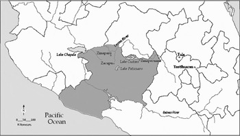
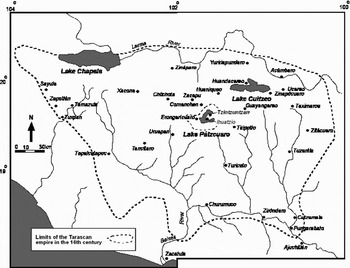
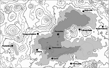
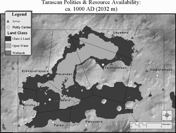
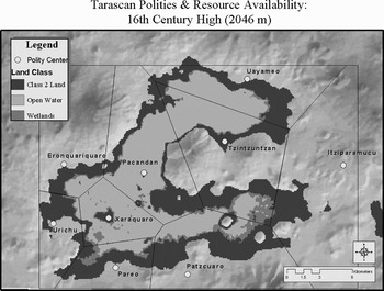
Knowledge of the state as it existed in the early sixteenth century provided an end point for the modeled transformation of the basin (Figures 1–3). I then made a series of assumptions about the nature of settlement in the centuries immediately prior to the emergence of the state, thereby establishing a set of initial conditions. I set my beginning point at a.d. 1000, based on the dynastic history that had the state already centralized by a.d. 1350, and assumed that the elite centers that played major roles in the legendary history were autonomous polities, each supporting local elites, prior to political centralization. The number and location of these centers was determined from the ethnohistoric and historical documents and limited archaeological survey (Gorenstein and Pollard Reference Gorenstein and Pollard1983). The potential agrarian and lacustrine resources available to these elites were determined by modeling with Thiessen polygons. As the environmental reconstruction indicated that the lake level in the sixteenth century was at least 10 m higher than the 1940s level, I used available aerial photos and topographic maps to determine available resources under low water conditions (Figure 4) and high water conditions (1540s [Figure 5]). As there were no appropriate demographic data for the period before the state, I modeled the impact of lake-level change under several conditions, including (1) a population at 50% of carrying capacity; and (2) a population at 50% of the Contact-period settlement estimates. The estimates of Contact-period population were based on sixteenth-century population numbers, archaeological survey of Tzintzuntzan, and the number and type of settlements located in the basin (Gorenstein and Pollard Reference Gorenstein and Pollard1983). All versions of the modeling resulted in differential stress on the agrarian resources of the proposed polities, especially on the quantity and location of irrigable land, with the greatest levels of stress associated with the centers most prominent in the legendary history and home of the major protagonists.
Western Mexico.

Tarascan territory in 1522.

The Lake Patzcuaro Basin.

Tarascan polities and resource availability at approximately a.d. 1000, with lake level at 2,032 m asl.

Tarascan polities and resource availability in the sixteenth century, with lake level at 2,046 m asl.

By the early 1990s, archaeological, geographical, and ecological projects in the Patzcuaro Basin and adjacent Zacapu Basin had produced enough new data to confirm, modify, and reject parts of the earlier model. A series of sediment cores was taken from several of the lakes and marshes of Michoacan, including more than 20 from the Patzcuaro Basin (O'Hara et al. Reference O'Hara, Street-Perrott and Burt1993). Unlike earlier cores, the episodes of lake deposits were radiocarbon dated and clearly demonstrated significant fluctuation during the past 3,000 years. Major projects in ethno-ecology and lacustrine ecology had been carried out (Chacón Torres Reference Chacón Torres1993; Toledo Reference Toledo, Oldfield and Alcorn1991; Toledo and Barrero-Bassols Reference Toledo and Barrera-Bassols1984), allowing much more accurate resource estimates, and archaeological work in the Zacapu Basin by the Centre d'Etudes Mexicaines et Centraméricaines (CEMCA) (Michelet et al. Reference Michelet, Arnauld and Fauvet-Berthelot1989) had established the first regional cultural sequence dated by 14C in Michoacan. A series of salvage and other Instituto Nacional de Antropología e Historia (INAH) projects provided additional evidence of Epiclassic and Postclassic period sites in central and northern Michoacan (Macías Goytia Reference Macías Goytia and Serret1988, Reference Macías Goytia1990; Piña Chan and Oí Reference Piña Chan and Oí1982;). By 1993, when I presented a second version of a model of the emergence of the Tarascan state, my first season of excavations at Urichu allowed me to document continuous occupation at one of the named elite centers from the Epiclassic period until the Spanish Conquest (a.d. 650–1525).
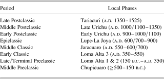
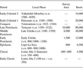
Finally, after several fits and starts over the twentieth century, the past two decades have seen the establishment of major programs of modern archaeology and ethnohistory in Michoacan. This has resulted in the first chronometrically dated and stratigraphically defined sequences of occupation from several of the lake basins of central and northern Michoacan (Table 1); regional surveys in these lake basins, with targeted surveys for salvage projects in many other parts of the state; and analysis and transcription of sixteenth- and seventeenth-century documents in Spanish and Purepecha. There are now four careful transcriptions of the Relación de Michoacán (Reference Tudela1956, 1980, Reference Franco Mendoza and de Michoacan2000, Reference Escobar Olmedo, Nacional and de Morelia2001). The 2001 edition is a complete facsimile publication with high-quality color images of the 44 drawings and an accompanying volume of analysis and commentary. These new sources of data are making it possible not just to propose but also to test models of long-term sociopolitical change, stability, and ethnogenesis.
Central-north Michoacan: Phases

PUREPECHA ETHNICITY AND STATE EMERGENCE IN THE PATZCUARO BASIN
During the Late Postclassic period, the Patzcuaro Basin was the geopolitical core of the empire, containing the imperial capital at Tzintzuntzan and major state religious complexes at Ihuatzio and Patzcuaro (Figures 2–3; Table 2). Demographic and settlement trends within the Purepecha heartland of the Tarascan core can be documented based on regional archaeological surveys in the Zacapu and Patzcuaro Basins and documents pertaining to the Patzcuaro Basin, especially Tzintzuntzan (Aguilar González Reference Aguilar González2005; Arnauld and Faugère-Kalfon Reference Arnauld, Brigitte and Darras1998; Beltrán Reference Beltrán1982, Reference Beltrán and de Lameiras1994; Esparza López Reference Esparza López1999; Fisher et al. Reference Fisher, Pollard, Israde, Garduno and Banerjee2003; Healan Reference Healan1997; Martínez Baracs Reference Martínez Baracs2005; Michelet Reference Michelet, Manzanilla and López Luján1995; Migeon Reference Migeon and Darras1998; Novella et al. Reference Novella, González and Cos2002; Phillips Reference Phillips2002; Pollard Reference Pollard1993, Reference Pollard2000, Reference Pollard, Sanders and Mastache2003; Pulido Méndez Reference Pulido Méndez2003; Silverstein Reference Silverstein2000, Reference Silverstein2001; Valdez and Liot Reference Valdez, Liot and de Lameiras1994). Together, the archaeological, ethnohistorical, and historical evidence confirm the presence of a distinguishable Purepecha cultural tradition by the Late Preclassic period in the Patzcuaro Basin and the emergence of a politically centralized and socially stratified state in the same basin during the Middle Postclassic period.
Late Postclassic period Patzcuaro Basin (Tariacuri phase) central places

aEstimated.
bCaravajal list of 1524 indicates similar population to Urichu (Warren Reference Warren1985), but others do not.
While maize pollen from sediment cores dating to 1500 b.c. indicate that the Patzcuaro Basin was probably first inhabited by sedentary or semi-sedentary farmers during the Early Middle Preclassic period, there is currently no archaeological confirmation. Evidence from the Bajio and Cuitzeo Basins, and the following period suggests that it is likely that these populations were culturally part of the Chupicuaro tradition (Darras Reference Darras2006; Darras and Faugère Reference Darras, Faugère, Williams, Weigand, Mestas and Grove2005; Darras et al. Reference Darras, Faugère-Kalfon, Durlet, Javier Reveles, Omar Cervantés, Caillaud and David1999; Porter Weaver Reference Porter Weaver and Frierman1969).
Loma Alta Phase (150 b.c.–a.d. 550)
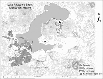
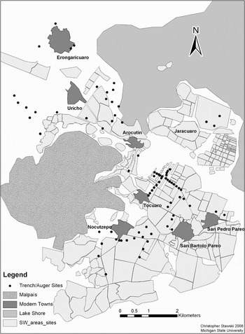
Based on recent research in the Patzcuaro Basin carried out by the Erongaricuaro Project (2001–2006), the Urichu Project (1990–1996), and the Urichu, Xaracuaro, and Pareo Polities Project (1995–1998) (Figure 6), it is possible to document Loma Alta-phase settlements at lacustrine and non-lacustrine settlements (Pollard Reference Pollard2000, 2005a), including Tzintzuntzan, based on sherds incorporated in Late Postclassic period deposits (Carot Reference Carot2001:71). Currently, Erongaricuaro is the only site of the phase with architectural remains. The survey, excavations, and local brick makers' trenches confirm a site more than 20 ha in size (Pollard Reference Pollard2005b; Pollard and Haskell Reference Pollard and Haskell2006; Figure 7). Five radiocarbon dates and associated ceramics and lithics place the stone walls, clay floors, formal hearths, and burials in the Loma Alta 2 and Loma Alta 3 phases. Loma Alta settlement also is documented in irrigation canals (Fisher et al. Reference Fisher, Pollard and Frederick1999) (Figure 8). These canals are associated with wetland cultivation and were found in trenches excavated 1.5 m below the modern surface under prehistoric soils and more than a meter of Colonial-period and modern eroded soil. During the centuries between 100 b.c. and a.d. 600, the level of the lake fluctuated between approximately 2,033 and 2,035 m asl (Fisher et al. Reference Fisher, Pollard, Israde, Garduno and Banerjee2003). The evidence of the density and size of settlements in the survey area suggests a basin population of only 5,000–8,000 people (Table 3).
The Lake Patzcuaro Basin survey zone.

The Loma Alta phase at the site of Erongaricuaro: (a) Agropecuaria trichrome with black; (b) Tres Palos red and black on cream; (c) Loma Alta 3 hearths and stone walls.

Auger and trench sampling locations within the survey zone, carried out by Christopher Fisher in 1996.

Population of the Lake Patzcuaro Basin

Note: Pre-Hispanic phases are defined by excavations at Urichu (Pollard Reference Pollard2000) and Erongaricuaro (Pollard Reference Pollard, Sanders and Mastache2003). Survey area population estimates are from Fisher et al. (Reference Fisher, Pollard, Israde, Garduno and Banerjee2003) and for basin from extrapolation of percentage of basin and ecological zones occupied (Gorenstein and Pollard Reference Gorenstein and Pollard1983). Basin population estimates for Tariacuri and Early Colonial periods are from Gorenstein and Pollard (Reference Gorenstein and Pollard1983). Survey area population was determined by site area and ceramic artifact density using the methods developed for the Basin of Mexico (see Fisher et al. Reference Fisher, Pollard, Israde, Garduno and Banerjee2003). Basin estimates for the Late Postclassic and Early Colonial periods are based on historical population figures and the archaeological surveys of Tzintzuntzan and Ihuatzio (see Gorenstein and Pollard Reference Gorenstein and Pollard1983; Pollard Reference Pollard, Sanders and Mastache2003).
At Erongaricuaro, long-distance exchange is documented in obsidian from northern Michoacan (Ucareo, primarily, and the Zinaparo complex) (Darras Reference Darras and Darras1998, 1999; Healan 1997; Pollard 2005a). All of the prismatic blades are from central Mexico (Pachuca). Instrumental neutron activation analysis (n = 50) confirms that all pottery was made of local pastes, with one exception: a Thin Orange sherd from Teotihuacan (Robert J. Speakman, MURR, personal communication 2003).
The type site for the phase is the 12 ha site of Loma Alta, located in the lacustrine zone of the Zacapu Basin (Arnauld et al. Reference Arnauld, Carot and Fauvet-Berthelot1993; Michelet et al. Reference Michelet, Arnauld and Fauvet-Berthelot1989). Excavations confirmed the existence of an architectural complex that included a sunken plaza with a central altar, walls of worked stone, and stairways (Carot Reference Carot2001, Reference Carot and Cornejo2004; Carot and Fauvet-Berthelot Reference Carot, Fauvet-Berthelot, Williams and Weigand1996; Carot and Ponce López Reference Carot and Ponce López1997; Carot et al. Reference Carot, Fauvet-Berthelot, Karl Link, Ortiz, Hesse, Avila, Emphoux, Gastélum, Ramírez, Schondube and Valdez1998; Pereira Reference Pereira, Williams and Weigand1996). The architectural complex is similar to that found in the salvage excavations at Santa María (in the suburbs of Morelia) and many others known from the Lerma River Basin in Guanajuato and Michoacan (e.g., Zaragoza [Fernández-V. Medina Reference Medina, and García2004]; Nogales [Pereira et al. 2007]).
The recent documentation of the Loma Alta phase in many parts of central and northern Michoacan has provided clear evidence of a period of transition between the earlier Chupicuaro society of 500–200 b.c. and the later societies of the Classic and Postclassic periods from which the Tarascan state emerged. Loma Alta has now been found in the Patzcuaro Basin, the Zacapu Basin (the Lomas, El Palacio, and Las Milpillas sites [Carot 2001]), Tiripitio (Igor Cerda Farías, personal communication 2006), Morelia (Santa María [Carot Reference Carot2001; Manzanilla López Reference Manzanilla López1988]), and at several sites in the Cuitzeo Basin (Querendaro, Zinapecuaro [Carot 2001]), and is closely related to the Mixtlan phase of the Bajio. At the type site in the Zacapu Basin, the appearance of sunken plaza/platform architecture in the Loma Alta 2b phase (a.d. 250–350) is associated with construction materials of basalt and clay brought from almost 10 km away and a new burial tradition in which richness of interment is directly related to proximity to platform centrality (Pereira Reference Pereira, Williams and Weigand1996). These burial deposits are currently the best evidence for the timing of the emergence of social ranking among the populations of central Michoacan. In all cases, they document the existence of small-scale, socially ranked agrarian societies. Only expanded excavation at these sites will enable us to determine the nature and degree of variation between households, and from that, the political economies that characterized the region. However, recent studies at Teotihuacan have documented Loma Alta figurines, vessels, and burial forms in one house compound in the Oaxaca barrio (Gómez Chávez Reference Gómez Chávez1998) and bone- and tooth-isotope studies indicate that the residents may have spent part of their adult lives in the Patzcuaro Basin (Michael Spence, personal communication 2006).
Lupe-Early Urichu Phases (a.d. 600–1000/1100)
During the Epiclassic period Lupe phase, at least seven settlements occupied the southwestern portion of the Patzcuaro Basin. Four were lacustrine, and three were back from the lake, including villages at Urichu and Erongaricuaro (Pollard Reference Pollard2000). The population is estimated to have been between 600–1,000 for the survey area and 6,000–7,000 for the basin (Table 3). Lake levels continued to fluctuate during this phase but were never very low. A deeply buried irrigation canal associated with maize phytoliths attests to the use of wetland agriculture. This is the only evidence of a Lupe-phase occupation near Charahuen and indicates that Epiclassic period sites are underrepresented due to later soil erosion. Trace-element studies indicate that ceramic production and use at Urichu remained localized, while the obsidian-distribution pattern changed significantly. Unlike the dominance of Ucareo gray-black obsidian in the Loma Alta phase, during the Lupe phase most obsidian artifacts tested from Urichu came from the Zinaparo complex, with only one artifact tested from any of the Lupe-phase sites of Ucareo obsidian (Pollard et al. Reference Pollard, Hirshman, Neff, Glascock, Williams and Weigand2001). Ceramics from Tzintzuntzan (Tz-59, 63, 70) indicate Lupe-phase occupation northeast of the INAH archaeological zone. The ceramic collections were part of my surface survey in 1970 and are housed at Michigan State University. At the time of the original research, this Lupe material was interpreted as reflecting ethnic variation. Stratigraphic excavations at Urichu have confirmed the material as Epiclassic period in date.
In the adjacent Zacapu Basin, archaeological survey has located 10–11 sites dated to the late Lupe phase with plazas and ballcourts (Michelet Reference Michelet1992). This was a time of major increase in settlements, especially toward the Lerma River (e.g., Zaragoza [Fernández-V. Medina 2004]; Barajas [Pereira et al. Reference Pereira, Michelet and Migeon2007]), and major expansion of obsidian mining at the Zinaparo complex (Darras Reference Darras1999). While this was also a time of expansion at the Zinapecuaro-Ucareo mines, Ucareo obsidian was primarily flowing east into central Mexico and appeared as the primary source for gray-black obsidian at, for example, Xochicalco and the Prado and Corral phases at Tula. Thus, we can clearly document a changing relationship between the political economies of central Mexico and the Purepecha polities.
Excavations at the sites of Urichu and Erongaricuaro reveal the presence of local elites during the Epiclassic period (Pollard Reference Pollard, Williams and Weigand1995, 2000). In addition, there is evidence of Epiclassic-period elite at Tingambato (Lagunas Rodríguez Reference Lagunas Rodríguez1987; Piña Chan and Oí Reference Piña Chan and Oí1982), Guadalupe (in the Zacapu Basin [Arnauld et al. Reference Arnauld, Carot and Fauvet-Berthelot1993; Michelet Reference Michelet1992; Michelet et al. Reference Michelet, Arnauld and Fauvet-Berthelot1989, Pereira 1999]), and Tres Cerritos (in the Lake Cuitzeo Basin [Macías Goytia Reference Macías Goytia1989; Macías Goytia and Vackimes Serret 1988]). While there are no chronometric dates from Tingambato or Tres Cerritos, and limited publication of results from all of the sites, these data can place the Patzcuaro evidence within a regional context.
In the period a.d. 500–700, elites residing in centers throughout central Michoacan shared a heritage from the Chupicuaro and Loma Alta societies reflected in ceramics and many aspects of mortuary behavior, including the dominance of primary extended burials and the association of shell beads with children's and, occasionally, female burials (Porter Weaver Reference Porter Weaver and Frierman1969). By the Late Classic period, the elite were buried in group tombs that were similar to each other in their use over multiple generations and in their methods of construction (Pollard and Cahue Reference Pollard and Cahue1999). At all sites, only some families had formal tombs. Those interred in group tombs were buried with preciosities imported as finished goods of raw materials derived from many parts of Mesoamerica, including Atlantic and Pacific ocean shell, turquoise, hematite, Pachuca green obsidian, jadeite, pyrites, rock crystal, and crysacolla, and locally made polychrome ceramic vessels (often with annular bases and/or resist decoration). Such grave goods, as well as cranial deformation and dental mutilation, distinguished these families. Local elite status may have been partially derived from their participation in the macro regional-exchange system by which such goods were obtained. The items' importation as finished goods reveals the connection of these elites on social/economic power embodied in ritual paraphernalia that was generated in other parts of western Mesoamerica. At both Guadalupe and Tres Cerritos, greenstone masks in Teotihuacan style and a few Thin Orange sherds (Guadalupe) and possible local copies of Thin Orange vessels (Tres Cerritos) indicate one source of prestige goods during the beginning of this period, but many of the goods are Toltec in design (flutes, censers, projectile points). The burials of these elites, including children, not only reveal their role as intermediaries with distant powers but self-define the males as warriors, with projectile points, atlatls, maces, and the costumes of warriors (Pereira Reference Pereira1999).
Despite their common cultural tradition, the elites varied in the size and architectural complexity of the centers they controlled and the degree of internal social ranking. This variation is observed in the size of tombs, range of individuals, and ratio of grave goods per person. Urichu appears to have had primarily males buried in the single excavated tomb, but females, children, and infants were buried under floors and in small stone cists. Unlike the Guadalupe tombs from the Zacapu Basin only 20 km away, which included no polychrome vessels, most vessels from Urichu had both polychrome and negative resist decoration (Pollard and Cahue Reference Pollard and Cahue1999).
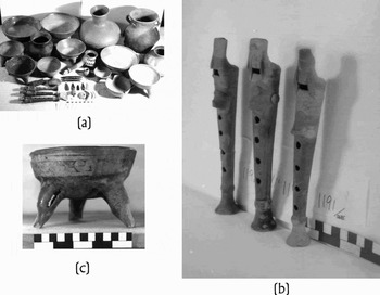
From a.d. 700 to 900/1000 the burial tradition continued at Urichu, presumably representing direct descendants of earlier elites. However, the number of grave goods per individual rose dramatically (Figure 9). Indeed, the individual with the greatest number of associated goods was buried with projectile points and whole prismatic blades, items that in the Late Postclassic period were associated with the hunter-warrior deity Curicaueri and males (Pollard Reference Pollard1993:137, 179). Whether this increase in grave goods per individual occurred at other elite centers is not known due to the disturbance of burials from repeated use of the tombs and the absence of absolute dates from the tombs at other sites. This represents at Urichu an increase in the capacity of local elites to obtain and bury exotic goods and to capture the labor of local producers of polychrome and resist ceramics.
Lupe-Early Urichu-phase burial goods. Tomb 1, Burial 13, Urichu: (a) all burial goods; (b) flutes; (c) Urichu red on beige with resist.

During the Early Urichu phase (a.d. 900/1000–1100) in the survey area, the number of sites increased, with almost a doubling of hectares occupied. The lake level began to drop, and lacustrine settlements moved to the new lake margins, as revealed by new settlements below 2,031 m asl (Figure 10). By the end of this phase, at least one settlement was at 2,028 m asl (Pollard, personal observation 2004), indicating the lowest lake levels in the past two millennia. Soil erosion was low to moderate around these newer settlements (Fisher et al. Reference Fisher, Pollard, Israde, Garduno and Banerjee2003); there is evidence of continued canal irrigation. Ten sites were located within the survey zone, including the first small settlements on islands and marsh zones that were later under water, and the first evidence of settlement in the southwestern upland zone near modern Ajuno. A new area (9) at Urichu was occupied with terraces, mounds, and retaining walls similar to those recorded from the Zacapu Basin (e.g., Mich 148). The population is estimated to have been 1,000–2,000 for the survey area and about 12,000 for the basin (see Table 3).
Settlement growth between a.d. 900 and 1522 in the survey zone: (a) Early Urichu phase, with 1,000–2,000 persons and 23–43 persons per km2; (b) Tariacuri phase, with 7,000–13,000 persons and 182–334 persons per km2.

Regionally, this phase has not been isolated in other projects, except near the obsidian source of Ucareo (Healan Reference Healan1997). However, gray-black obsidian was still primarily from the Zinaparo complex, while the Ucareo obsidian continued to flow east, probably through networks dominated by merchants from the Toltec state (Mastache et al. Reference Mastache, Cobean and Healan2002). Ceramic production and distribution remained highly localized (Pollard et al. Reference Pollard, Hirshman, Neff, Glascock, Williams and Weigand2001).
This phase marks the last use of the tomb excavated at Urichu and the end of multiple-use tombs in Michoacan. The last three burials in the tomb at Urichu are the richest, with objects imported from central Mexico, some of which may be ritual paraphernalia from Tula or in Toltec style (flutes, censer) (Figure 9).
Late Urichu Phase (a.d. 1000/1100–1350)
This phase includes the two centuries during which the Tarascan state formed and to which the legendary accounts of state emergence and ethnic affiliation pertain. Archaeological evidence comes from excavations at Urichu and survey in the southwestern portion of the Patzcuaro Basin. There is some comparative data from the Zacapu and Cuitzeo Basins, although there the phase has not been chronometrically isolated (Carot Reference Carot and Manzanilla2005).
In the Middle Postclassic period, the number of sites in the Patzcuaro Basin increased, and the area of occupation again doubled. A large proportion of the new sites were located on recently exposed islands and on fertile lacustrine soil exposed by an episode of lake regression (Fisher et al. Reference Fisher, Pollard, Israde, Garduno and Banerjee2003). The lake level was at its lowest since first human occupation of the basin; soil erosion was local and focused around new settlements.
Within the survey area 105 collection units were located, 32 of which were hamlets and towns, and the remainder were scattered household clusters located adjacent to the lakeshore or in marshes. Settlement expanded onto islands as the lake level dropped but also markedly expanded in upland zones and on to the malpaís in defensible locations. The population is estimated at 4,000–7,800 for the survey area, with up to 48,000 people for the basin. This represents major population growth in the basin and in surrounding central and northern Michoacan. Nevertheless, basic resources such as obsidian, basalt, and pottery were being produced, distributed, and consumed in patterns unchanged since the Classic period.
In the last decades of this phase, the lake level rose again, reaching its Contact-period level above 2,041 m asl. This resulted in the abandonment of low-lying communities and agricultural land and the relocation of marsh production zones. Given the population size in the basin and the existence of sociopolitical elites in the large communities, competition over expanding, diminishing, and shifting resources must have become fierce. Moreover, environmental data suggest that similar patterns would have been occurring throughout central and northern Michoacan.
In the Zacapu Basin, the Postclassic period began with an increase in the number of sites and a shift from primarily lakeshore occupation to marked increases in sites located in the malpaís above Zacapu and the uplands toward the Lerma River (Arnauld and Faugère-Kalfon 1998:16; Michelet et al. Reference Michelet, Pereira, Migeon and Manzanilla2005). In general, settlement appears to have maximized access to agricultural land; defensive position; and continued development of the nearby obsidian mines of Zinaparo. Sunken patios disappeared from public architecture and were replaced by square rooms with columns and covered porticos. On the malpaís by a.d. 1200, the density of settlement increased to urban levels, and up to 20,000 people are estimated to have inhabited the 13 sites covering 5 km2 (Migeon Reference Migeon1990, Reference Migeon, Breton, Berthe and Lecoin1991, Reference Migeon and Darras1998; Puaux Reference Puaux1989). Michelet (Reference Michelet, Manzanilla and López Luján1995) interprets this as reflecting relatively rapid movement of individual communities onto the malpaís, clustering together for defense and, shortly thereafter (a.d. 1250), each reorganizing under the control of a single authority. A similar process seems to have been happening just to the east of the Patzcuaro Basin, where a 1,200 ha clustering of communities emerged on the hill slope above modern Tiripitio (Igor Cerda Farías, personal communication 2006).
The Purepecha cultural heartland by now was composed of several competing chiefly/small state societies. This was a transition period when settlement shifted and elite mortuary patterns changed. Both the archaeological and ethnohistoric records suggest that patterns of leadership and control were in flux. While the legendary histories record several episodes of migration of non-Purepecha populations into the region, to date they are not visible in the archaeological record.
THE POLITICAL ECONOMY OF STATE AND EMPIRE: THE TARIACURI PHASE (a.d. 1350–1525)
During this phase, low-lying sites were flooded and settlement shifted to the new lakeshore and to areas of high agricultural fertility back from the lakeshore (Figure 10). The lake level was high (above 2,041 m asl), with earlier settlements below water (O'Hara Reference O'Hara1993). Soil erosion was minimal, even as settlement expanded upland due to widespread terracing and other soil-management strategies (Fisher et al. Reference Fisher, Pollard, Israde, Garduno and Banerjee2003). The data from all surveyed regions in central and northern Michoacan suggest that population density reached its highest during the Late Postclassic period. Gorenstein and Pollard (Reference Gorenstein and Pollard1983) estimated that population in the Patzcuaro Basin was located in 90–95 settlements and was about 80,000 in a.d. 1522. A number of communities were functionally differentiated, and settlements varied considerably in their area and population (Table 2). Tzintzuntzan was a regional primate center not only on the basis of population size, but also based on its control of the administrative, tributary, market, religious, and social settlement hierarchies.
Given the increasingly dense occupation, which occurred during a time of very high lake levels when previously irrigable land was flooded, new economic mechanisms were required to support local populations. That is, by a.d. 1300 lake levels began to rise again, forcing lakeshore communities and fields to be abandoned (Fisher et al. Reference Fisher, Pollard and Frederick1999; Fisher et al. Reference Fisher, Pollard, Israde, Garduno and Banerjee2003; Metcalfe et al. Reference Metcalfe, Davies, Braisby, Leng, Newton, Terrett and O'Hara2007; O'Hara Reference O'Hara1993; O'Hara et al. Reference O'Hara, Street-Perrott and Burt1993). Goods and services were imported and exported through local and regional markets and various state institutions (Pollard Reference Pollard1993). Both the type and quantity of goods imported varied within the Patzcuaro Basin by social class and community and represented changes from periods before the emergence of the state (Hosler Reference Hosler1994; Hosler and MacFarlane Reference Hosler and Macfarlane1996; Pollard Reference Pollard1993, Reference Pollard, Sanders and Mastache2003; Pollard et al. Reference Pollard, Hirshman, Neff, Glascock, Williams and Weigand2001; Warren Reference Warren1968). The emergence of a centralized state in the Patzcuaro Basin and its subsequent expansion was associated with a marked increase in the scale of production and, possibly, a restriction of (some of) the control of the technology, raw materials, and products to core elites and, especially, the royal dynasty.
The royal dynasty officially allocated access to land, water, forests, and mineral resources (Pollard Reference Pollard1993). In practice, access to land was distributed within communities by traditional kinship ties, and land was acquired by kings for support of state administrators (angámecha) and state temples. In addition, there were state copper mines, obsidian mines, forests, fisheries, and craft workshops. There were no obsidian or copper mines in the Patzcuaro Basin; the documentary record is unclear about the status of fishing and forestry rights—that is, the degree to which they were seen as resources traditionally held by specific communities or resources to which communities were allowed access by the king. Sixteenth-century documents suggest the latter, but if so, this was a change in the ideology of resource ownership that could have emerged only with the unification of the state in the Middle Postclassic period.
Socially, the division between nobility and commoner was virtually absolute. Among the nobility, distinctions were made among the royal dynasty, the upper nobility, and the lower nobility. Commoners varied by ethnicity (although overwhelmingly Purepecha), occupation, and status as slaves. Archaeological excavation has defined the material correlates of elite status in residential and mortuary contexts (e.g., Pollard and Cahue Reference Pollard and Cahue1999; Pollard Reference Pollard, Williams, Weigand, López Mestas and Grove2005a). Elites and commoners located in secondary and tertiary centers of the basin (e.g., Table 2) consumed goods identical to those from the capital, shared Tarascan elite and commoner identity, and participated in a single social system. Changes in the burial practices of local elites from the Lupe-Early Urichu phases document a transformation of these elites from highly ranked local chiefs into a socially stratified elite class. This transformation involved a shift in elite identity from one primarily associated with imported finished goods from distant powerful centers and control of prestige goods networks, to an identity primarily associated with locally produced, distinctively Tarascan, goods and control of tributary, military, political, and ideological networks (for specific evidence, see Pollard and Cahue Reference Pollard and Cahue1999). Inequalities in wealth, status, and power, as revealed by the material record, were at their greatest for the pre-Hispanic era.
The creation of the Tarascan state was accompanied by the establishment of a new ideology that made the Patzcuaro Basin the center of cosmic power (Pollard Reference Pollard1993). The roots of this ideology came from the different cultural traditions that characterized Postclassic period Michoacan populations. The patron gods of the now dominant ethnic elite were elevated to celestial power, while the various regional deities and worldviews, which themselves were products of generations of change, were elevated, incorporated, or marginalized. The clearest evidence of this process involves the joining of the ethnic Chichimec, or uacusecha, deity Curicaueri with the ethnic Islander, or Purepecha, goddess Xaratanga. In the prophetic language of a great epic, “Curicaueri will conquer this land, and you for your part will stand with one foot on the land and one on the water … and we shall become one people” (Relación de Michoacán Reference Miranda1980:40). Their joint worship at Ihuatzio and Tzintzuntzan was a direct product of this unification, reinventing them as husband (sun) and wife (moon).
This union of deities previously associated with distinct ethnic/political groups can also be seen in the ritual centers constructed in the Tarascan core. A specialized pyramid form, the yácata, consisting of a keyhole shape, was constructed at major religious centers associated with the Tarascan sun god Curicaueri. Stone chacmool sculptures were placed in front of the yácata at Tzintzuntzan and Ihuatzio, scenes of major ceremonies celebrating the state and cosmic order. The strong similarities of portions of Tarascan state religion, especially that associated with the ruling elite's patron deity Curicaueri, are due not to emulation of the Late Postclassic period Nahua traditions but to shared heritage and interaction through the Bajio from the Epiclassic to the Middle Postclassic period (Stone Reference Stone2004: 275).
For the Purepecha (commoners) of central and northern Michoacan, this new society was a massive transformation on the macro level, but with great continuities on the household and village scale. The social continuity represented by the long cultural tradition from the Preclassic to the Postclassic is visible in ceramic technology, ceramic designs, the use of negative resist on polychrome pottery, the types of figurines, mortuary patterns, basic technology, diet, and household organization of labor. Specific artifacts, such as molcajetes (chile grinders) with punctate (shallow depressions) instead of incised lines in the interior bases, and the absence of mold-made figurines throughout the sequence emphasize the degree of continuity at the level of the household, despite major changes in the political economies that took place during these 2,000 years. In addition, there is evidence of specific continuities in ideology that exist among adjacent phases. For example, the recent excavations at Chupicuaro sites reveal burials within round platforms, similar to those found at the site of Loma Alta (Carot et al. Reference Carot, Fauvet-Berthelot, Karl Link, Ortiz, Hesse, Avila, Emphoux, Gastélum, Ramírez, Schondube and Valdez1998; Darras et al. Reference Darras, Faugère-Kalfon, Durlet, Javier Reveles, Omar Cervantés, Caillaud and David1999). While it may never be directly testable, I suggest that this continuity in the material culture and ideology was matched by a continuity in language and that Purepecha was spoken throughout these two millennia in central and northern Michoacan.
THE CURRENT MODEL
What do all these data contribute to our understanding of the processes of state formation in central Michoacan? First, it must be noted that there are still huge gaps in our knowledge of the regional prehistory. Of particular note, the Patzcuaro Basin has been systematically surveyed only partially, and the Middle Postclassic period remains very poorly documented. Nevertheless, a number of points can be made.
(1) The time period during which there are competing centers with socially differentiated elites in the basin has been extended from the Early Postclassic back to the Late Preclassic period.
(2) Irrigation as a form of agricultural intensification is dated to the same time span as these elites, although the currently documented canals are associated with small village settlements.
(3) The nature and social identity of these elites changes over time. During the Loma Alta phase, elite burials are primarily distinguished by proximity to ritual spaces and are often individual. By the Lupe and Early Urichu phases, they are buried in formal group tombs, with significant variation in wealth and social status. I suggest that agnatic kin groups are now socially differentiated, with more formally restricted chiefly lineages. They show many of the characteristics of network political economies and use exotics from distant powers to the east to reinforce their social power (Teotihuacan during the Loma Alta phase; Tula during the Lupe-Early Urichu phases) (Blanton et al. Reference Blanton, Feinman, Kowalewski and Peregrine1996; Helms Reference Helms1993). As Pereira (Reference Pereira1999) emphasizes there is also a shift in the nature of leadership from primarily ritual leaders in the Loma Alta phase to warrior leaders by the Lupe phase.
(4) Demographic estimates suggest rapid population growth between the Lupe and Early Urichu phases, a time period during which climate fluctuation produced a lake regression. Many new settlements were founded on the exposed land at the same time that large centers were founded or enlarged on defensible malpaís. This indicates the growing use of warfare to mediate intergroup conflict, some of which may have involved these new agrarian resources.
(5) Between the Early and Late Urichu phase, population continued to grow as the lake levels started to rise again. The new data do not change the previously proposed model of elite competition over shifting resources, but they do limit the period of transformation to fewer than two centuries.
(6) My earlier model had included consideration of existing similar polities surrounding the Patzcuaro Basin, limiting the options of basin elites to adjust to changing resources, including elites who would form alliances, and initiate hostilities, with basin polities. I had not sufficiently valued the role of central Mexican states in directly or indirectly affecting the nature of local basin polities. While the evidence for interaction is limited and probably mediated by long-distance traders, local elites must have been embedded enough in the central Mexican world to choose to participate in the “elite exchange network” and to derive some of their local authority from that participation. Specifically, evidence exists of links between north-central Michoacan and Teotihuacan (Carot and Ponce López 1997; Filini Reference Filini2004; Gómez Chávez Reference Gómez Chávez1998; Pollard 2005a) and Tula (Paredes Gudiño Reference Paredes Gudiño and García2004; Pereira Reference Pereira1999; Pollard and Cahue Reference Pollard and Cahue1999). Of note is the absence of any evidence of significant interaction with populations farther west, such as those of highland Jalisco prior to the military expansion of the Tarascan state.
(7) The formation of the Tarascan state seems to have occurred in the context of marked demographic expansion and rising lakes levels (following a period of adaptation to falling lake levels) after several centuries of increasing social and political differentiation. Demographic expansion in this context made kinship mechanisms inadequate to manage political relations (Hammel Reference Hammel2005).
This “perfect storm” could have simply resulted in social fission with out-migration. Stone (Reference Stone2004:143–146) believes this is probably what had occurred earlier in basin history, as recounted in episodes in the Relación de Michoacán when priests and others carry their patron idols from one place to another. The two centers whose resources would have been seriously affected were Tzintzuntzan and Patzcuaro, major protagonists in the Tarascan official history. In 1982, I proposed that each center politically incorporated an immediate neighbor to seize tributaries or resources creating two supra-polities in the basin (Patzcuaro-Pareo and Tzintzuntzan-Uayameo), as appear to be indicated in the Relación de Michoacán. This would have resulted in changes in both the internal dynamics of these polities and their relationships with others of the region. In legendary terms, this is followed by a century of conquest, betrayal, and alliances within and outside the Patzcuaro Basin associated with the rise of the great warrior leader Tariacuri and the political unification of central Michoacan (Figure 11). Tariacuri's prophetic dream of a unified state mandated by his god was interpreted in the following decades as the “event” that de-legitimized all previous and competing claims to authority (Beck et al. Reference Beck, Bolender, Brown and Earle2007; Sewall Reference Sewall William and William1996).
Tariacuri's imperial dream (Relación de Michoacán).

Thus, during the Middle Postclassic period a new political economy emerged dominated by a now socially stratified society. In the language of complex adaptive systems theory, the polities, leaders, and ecosystems of the Patzcuaro Basin may have been driven to the “edge of chaos,” producing the conditions for emergence, “the idea that complex global patterns with new properties may emerge from local interactions” (Lansing Reference Lansing2003:192) (Figure 12). Whether the societies of the Early and Middle Postclassic periods represent another case of variation in prehistoric chiefdoms (Drennan and Peterson Reference Drennan and Peterson2006) or a significantly different form of society that developed into a new prehistoric state (Yoffee Reference Yoffee2005) remains to be determined in the coming years of continued research and will be a major focus of study.
Population, resources, and leadership in the Lake Patzcuaro Basin.

RESUMEN
En 1982 presenté un modelo del surgimiento del Estado tarasco basado principalmente en la historia legendaria de la dinastía real tarasca, la Relación de Michoacán (1956 [1541]), y una reconstrucción medioambiental de la cuenca del lago de Pátzcuaro como se estaba en los inicios del siglo XVI (Pollard y Gorenstein 1980; Gorenstein y Pollard 1983). El modelo enfocó en el papel importante de variación climática, cambios en los recursos resultantes y el proceso decisorio político. Pero el modelo era sumamente tentativa ya que era basado solamente en datos de la cuenca de Pátzcuaro en el posclásico tardío, cuando era el centro geopolítico del Estado tarasco, y proyectó atrás a tiempo.
El conocimiento del Estado tarasco como existió a principios del siglo XVI proporcionó un punto final para la transformación modelada de la cuenca. Entonces, hice una serie de suposiciones sobre la naturaleza del patrón de asentamientos para los siglos inmediatamente antes del surgimiento del Estado, estableciendo un grupo de condiciones iniciales para eso. Fijé el punto inicial a d.C. 1000, basado en la historia dinástica que el Estado había centralizada ya por d.C. 1350, y suponía que los centros de la élite que jugaron los papeles mayores en la historia legendaria eran gobiernos autónomos, cada uno con élites locales, antes de la centralización política. y suponía que los centros de la élite que jugaron los papeles mayores en la historia legendaria eran gobiernos autónomos, cada uno con élites locales, antes de la centralización política. El número y las ubicaciones de estos centros eran determinados de los documentos históricos y los estudios arqueológicos limitados (Gorenstein y Pollard 1983). El potencial de los recursos agrarios y lacustres disponibles a estas élites era estimado con el uso de los polígonos de Thiessen. Como la reconstrucción medioambiental de la cuenca indicaba que el nivel del lago en el siglo XVI era por lo menos 10 m superior que el nivel de los 1940s, usé las fotografías aéreas disponibles y los mapas topográficos para determinar los recursos disponibles bajo las condiciones del agua baja (1940s) y del agua alta (1540s). Modelé el impacto del cambio en los niveles del lago bajo varias condiciones, incluyendo (1) una población a 50% de capacidad agraria y (2) a 50% de la población al momento de la llegada de los españoles. Todas las versiones producían una tensión sobre los recursos agrarios de los gobiernos propuestos, sobre todo en la cantidad y la ubicación de la tierra de riego, con los más grandes niveles de tensión asociados con los centros más prominentes en la historia legendaria y centros de los protagonistas mayores.
Con tres décadas de estudios arqueológicos, ecológicos y etnohistóricos, ahora es posible proponer un modelo del surgimiento del primer estado arcaico en Michoacan. Mientras está basado en los datos disponibles de la cuenca del lago de Patzcuaro, la cuenca de Zacapu, la cuenca del lago de Cuitzeo, el Bajío, la meseta tarasca y la zona del río Balsas, este modelo se propondrá para guiar los estudios futuros de campo, de laboratorio y de archivos. Los problemas críticos para resolver en futuras investigaciones incluyen: (1)¿porqué la formación estatal ocurrió (y porqué con la estructura conocida)? (2)¿porqué la formación estatal secundaria era “retardada'” para más de un milenio? (3)¿porqué ocurrió en la cuenca de Pátzcuaro? y (4)¿cuál fue el papel de la etnicidad purepecha en el proceso?
ACKNOWLEDGEMENTS
The Lake Patzcuaro Basin research described here has been funded by many sources over the years, including the National Science Foundation, the National Endowment for the Humanities, the Wenner-Gren Foundation for Anthropological Research, the Heinz Foundation, the National Geographic Society, and Michigan State University to the author. The Consejo de Arqueología of INAH and the INAH Regional Center–Michoacan has issued permits and assisted in many ways to aid the research process. Figures 4–5 were made by Brandon Nolan; Figures 6 and 8 were made by Christopher Stawski. New satellite-based GIS mapping of Tzintzuntzan by Christopher Stawski resulted in a new area-estimate for the Late Postclassic capital (Table 2). I thank Joseph Mountjoy and an anonymous reviewer for providing valuable critiques.