Introduction and history of research in the Land behind Nineveh
The recent stabilization and regional autonomy of Iraqi Kurdistan after decades of political instability, military and civil strife and economic and humanitarian crises have resulted in significant positive developments, not only in the political, economic and social life of the region, but also in areas of education, culture and scientific research. Since 2009, thanks to the liberal policy of openness to foreign missions pursued by the Directorates of Antiquities of Iraqi Kurdistan and the State Board of Antiquities and Heritage of Baghdad, the plains of the Iraqi Zagros foothills have been the focus of numerous archaeological excavations and survey projects. As a result, Iraqi Kurdistan is emerging not only as a new frontier in ancient Near Eastern archaeology, but also as a promising laboratory for the development and testing of innovative methods of archaeological research, especially in the field of landscape archaeology and multidisciplinary research (Menze et al. Reference Menze, Mühl, Sherratt, Ooghe and Verhoeven2007; Altaweel Reference Altaweel2008; Altaweel et al. Reference Altaweel, Marsh, Mühl, Nieuwenhuyse, Radner, Rasheed and Saber2012; Mühl Reference Mühl, Hofmann, Moetz and Müller2012; Ur et al. Reference Ur, de Jong, Giraud, Osborne and MacGinnis2013).
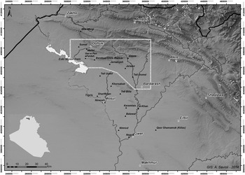
Until recently, the region of northern Iraqi Kurdistan has been the subject of only occasional and unsystematic archaeological research due to its political instability. Nonetheless, it has received some attention because of its close geographical relationship to the Assyrian capitals of Nineveh and Khorsabad which have attracted major field investigations since the mid-nineteenth century (Fig. 1). Unlike these sites, for which a significant, albeit often inadequate, amount of information has accumulated (for a recent summary, see Pedde Reference Pedde and Potts2012), the Dohuk area and the Transtigridian piedmont plains of Faideh, Al-Qosh, Ba'dreh, ‘Ain Sifni/Sheikhan and Navkur have long been archaeologically neglected. Early investigations were conducted by: Austen Henry Layard at the site of Jerahiyeh (Reference Layard1849: 33–34; Reference Layard1853: 94–95); the French consul at Mosul, Simon Rouet, who in 1845 discovered the rock reliefs at Maltai and Khinis (Rouet Reference Rouet1846; Thureau-Dangin Reference Thureau-Dangin1924); and Victor Place at both Maltai (tell and rock carvings) and Ger-e-pan (Place Reference Place1867–1870: 152).Footnote 3 At the beginning of the last century, Leonard W. King, followed by Walter Bachmann, conducted systematic studies and field observations on the Khinis reliefs (Bachmann Reference Bachmann1927), while in 1933 a team from the Oriental Institute of the University of Chicago excavated the monumental Neo-Assyrian aqueduct at Jerwan (Jacobsen and Lloyd Reference Jacobsen and Lloyd1935). Fundamental (but irregular and unsystematic) field research has been carried out since 1945 at several sites in the region connected with the massive irrigation system constructed in the Nineveh hinterland by the Assyrian king Sennacherib (Al-Amin Reference Al-Amin1948; Shukri Reference Shukri1954; Oates Reference Oates1968; Reade Reference Reade1973; Boehmer Reference Boehmer1975; Reade Reference Reade1978; Reade Reference Reade1988; Boehmer Reference Boehmer1997; Reade Reference Reade, Al-Gailani Werr, Curtis, McMahon, Martin, Oates and Reade2002; Reade and Anderson Reference Reade and Anderson2013). These archaeological, topographical and historical studies, although to some extent disconnected one from another, had the merit of drawing attention to the countryside around Nineveh and the problem of its water supply, posing for the first time important research questions on the management of economic resources (water and agricultural soils) at the heart of the Assyrian empire in the decades of its maximum expansion.
Location of the Land of Nineveh Archaeological Project (LoNAP) survey area in northern Iraqi Kurdistan (the core territory of the Assyrian empire) with major sites. © LoNAP

The first archaeological excavations conducted using modern scientific methods took place between 1981 and 1986 in advance of the construction of the Eski Mosul Dam on the Tigris. Some 149 archaeological sites were threatened, but, although excavations were conducted at many of them on both banks of the river, this led to a relatively modest number of final publications and was limited to the area of Zammar (Ball et al. Reference Ball, Campbell and Simpson2003; Simpson Reference Simpson2007), Kharabeh Shattani (Baird et al. Reference Baird, Campbell and Watkins1995; Watkins and Campbell Reference Watkins and Campbell1986), Nemrik (Kozlowski Reference Kozlowski2002), Tell Karrana 3, Tell Jikan and Tell Khirbet Salih (Wilhelm and Zaccagnini Reference Wilhelm and Zaccagnini1993), Tell Rijim (Koliński Reference Koliński2000), Khirbet Khatuniyeh (Curtis and Green Reference Curtis and Green1997), Khirbet Qasrij and Qasrij Cliff (Curtis Reference Curtis1992).Footnote 4 This work was followed, between 1986 and 1990, by an important survey of the nearby plain of the Jebel Sinjar, immediately to the west of the Iraqi Upper Tigris (Wilkinson and Tucker Reference Wilkinson and Tucker1995). For the first time, a landscape archaeology project studied systematically, and with concern for chronology, the development of settlement in a region of northern Iraq from the Neolithic until the rise of Islam (for the adjacent Sinjar and Wadi Tharthar areas, see Ibrahim Reference Ibrahim1986). However, the interruption in archaeological research since 1990 has so far prevented the full realization of the vast scientific potential of the Eski Mosul Dam rescue excavations. (DMB)
The Land of Nineveh Archaeological Project (LoNAP) goals
As a consequence of this limited excavation and publication, most of the pottery and other material culture that characterizes the northern “Assyrian Triangle” are still largely unknown. Similarly (and especially) a comprehensive and multidisciplinary archaeological picture: of settlement patterns, the use of land and resources, and the cultural dynamics the region has experienced is lacking—both during prehistoric and pre-classical epochs and the less well known period between Hellenism and the advent of Islam and the following age of the Kurdish emirates.Footnote 5 Although there has been some exploration of the Dohuk region, such as the Pre-Pottery Neolithic site of Nemrik (Kozlowski Reference Kozlowski2002), crucial questions remain concerning the economic, social and environmental changes that affected the region of the “hilly flanks” of the Iraqi Zagros between the end of the Pleistocene and the beginning of the Holocene, leading to the process of Neolithization (Braidwood and Howe Reference Braidwood and Howe1960; Braidwood et al. Reference Braidwood, Braidwood, Howe, Reed and Watson1983; Simmons Reference Simmons2007). The Zagros piedmont zone in northern Iraqi Kurdistan is a fundamental region for an understanding of the complex processes behind the economic and social transformation of human communities, as well as for investigating palaeoenvironmental changes and the biological modifications that occurred in the plant and animal populations involved in the processes of domestication. Other themes central to the historical and archaeological understanding of northern Mesopotamia, such as the appearance of the earliest urban centres and state formation during the Late Chalcolithic and Early Bronze Age, and the impact of the empires of the Iron Age and later periods on landscape and settlement patterns, have not been investigated in this region although in many cases it is here that they have their origins.
The Land of Nineveh Archaeological Project (LoNAP), initiated in 2012 by the Italian Archaeological Mission to Assyria of Udine University, is an integrated territorial project that aims through innovative strategies to understand the formation and transformation of the cultural and natural landscape of northern Mesopotamia (embracing large parts of the governorates of Ninawa and Dohuk) from the Palaeolithic to the Islamic period. The research is based on a regional archaeological surface survey in the area delimited by the plain of Dohuk and the Zagros foothills to the north, that run from the Tigris Valley west of Dohuk east to Akre and the Greater Zab, the lake formed by the Eski Mosul Dam to the west and the Navkur plain that extends from the Jebel Maqloub to the River Al-Khazir Valley and the Bardarash region to the east. Its purpose is to comprehend patterns of settlement, land use and management, especially with regard to fundamental resources: water and agricultural soils. This is accompanied by the study of population dynamics, lines of communication and the region's connections to the long-distance trade routes that crossed Upper Mesopotamia, and research into the material culture of the region and its evolution. These objectives are closely tied to the geoarcheological and bioarchaeological reconstruction of the ancient natural environment and its evolution as a result of global climatic fluctuations and human impact.Footnote 6
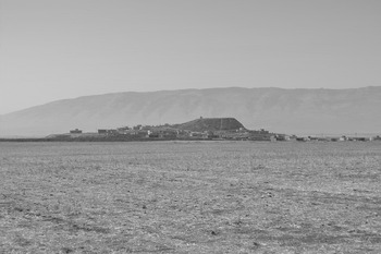
This survey work will be combined with an excavation at the site of Tell Gomel; preliminary exploration took place in 2014 and an open-area archaeological excavation is planned (Fig. 2). On the basis of the results of the field-walking survey, the site appears to have been continually inhabited between the Late Chalcolithic and the Late Islamic period.Footnote 7 It has been tentatively identified as the ancient Assyrian city of Gammagara (Reade and Anderson Reference Reade and Anderson2013: 75–76; Fales and Del Fabbro Reference Fales and Del Fabbro2014), known from Inscription B at Jerwan (Jacobsen and Lloyd: 20–21, 32), and as the later Gaugamela (Streck Reference Streck1910: 861–62; Marsden Reference Marsden1964: 20; Herzfeld Reference Herzfeld1968: 228; Seibert Reference Seibert1972: 127–30, 282–283; Schachermeyr Reference Schachermeyr1973: 268, 270; Lane Fox Reference Lane Fox1986: 228–43; Bernard Reference Bernard1990: 520; Reade and Anderson Reference Reade and Anderson2013: 76–77).Footnote 8 With its notable dimensions (a surface area of 15 hectares), continuous occupation for around seven millennia (revealed also by the height of the tell, more than 40 metres from the bed of the Gomel), its strategic position on the left bank of the river and almost at the centre of the fertile Navkur plain, Tell Gomel is the most important site in the area.Footnote 9 An excavation here will throw light on its long settlement history and yield typological series of ceramics, lithic industry and other archaeological artefacts, well-stratified and dated both relatively and absolutely, with reference to a programme of radiometric date determinations. This will give us stratigraphic and typological reference sequences, enabling us to better identify the surface finds gathered during survey work, refine the dating of surveyed sites and thus produce more reliable distribution maps of sites divided according to chronological period.
View of Tell Gomel (site 40) with the main mound and the southern lower town (September 2013). Jebel Maqlub is in the background. © LoNAP

This is the first intensive, systematic and interdisciplinary archaeological research project to be conducted in the heartland of the Neo-Assyrian empire (Morandi Bonacossi Reference Morandi Bonacossi2012–2013; Morandi Bonacossi in Reference Morandi Bonacossi, MacGinnis and Wickepress a). During the first centuries of the first millennium b.c., the region of the Transtigridian piedmont plains of Dohuk, Faideh, Al-Qosh, Sheikhan and Navkur constituted the geographic and political core of the Assyrian Empire. Little is known about the patterns of settlement and land-use in this area that provided essential support to Khorsabad and Nineveh, except for the western Assyrian homeland and along its northern frontier (Morandi Bonacossi Reference Morandi Bonacossi1996 and Reference Morandi Bonacossi and Bunnens2000; Wilkinson and Barbanes Reference Wilkinson, Barbanes and Bunnens2000; Parker Reference Parker2001; Wilkinson et al. Reference Wilkinson, Wilkinson, Barbanes, Ur and Altaweel2005; Matney Reference Matney, Steadman and Ross2010; D'Agostino Reference D'Agostino and Ströbel2011 and Reference D'Agostino and Mazzoni2012: 209–30; Ur Reference Ur and Frahmin press), but until now never in the heart of the “Land of Ashur” (but see now Ur et al. Reference Ur, de Jong, Giraud, Osborne and MacGinnis2013). In this context, one of its most important goals is the complete geo-archaeological and topographical analysis of the poorly understood canal system built by the Assyrian king Sennacherib (704–681 b.c.) to bring water to Nineveh. This massive, centrally-planned hydraulic system has been explored to date somewhat anecdotally, or on the basis of cuneiform inscriptions or remotely sensed images (Jacobsen and Lloyd Reference Jacobsen and Lloyd1935; Reade Reference Reade1978; Bagg Reference Bagg2000a and 2000b; Ur Reference Ur2005), but never by means of a field project; its extent, chronology and precise function are still uncertain. In cooperation with the Italian Ministry of Foreign Affairs and International Cooperation (Task Force Iraq), LoNAP is also engaged in the recording by laser scanning and digital photogrammetry of all rock reliefs and monuments that are connected to the canal system. Their three-dimensional recording is crucial not only for documentation and scientific research, but also for the design of an archaeological and environmental park of Sennacherib's hydraulic system, which will afford its both protection and accessibility.Footnote 10 (DMB)
Survey methodology
Archaeological field survey work in the territory assigned to LoNAP was preceded by the systematic examination of available cartographic sources and the analysis and interpretation of aerial and satellite imagery in order to identify potential archaeological sites and ancient infrastructure. Particularly useful were aerial photographs taken in 1955 by Hunting Aerial held by the British Institute for the Study of Iraq (BISI) and CORONA satellite images taken in the second half of the 1960s, at a time when urban growth and mechanized intensive agriculture had not yet radically altered and in part obliterated the archaeological landscape (Menze et al. Reference Menze, Mühl, Sherratt, Ooghe and Verhoeven2007; Altaweel Reference Altaweel2008; Mühl Reference Mühl, Hofmann, Moetz and Müller2012; Menze and Ur Reference Menze and Ur2012; Ur Reference Ur2003, Reference Ur2005, Reference Ur2010, Reference Ur, Comer and Harrower2013a, Reference Ur2013b). We also used the panchromatic images with 1 metre resolution of OrbView-3 (USGS Earth Explorer, 2003–2005), SPOT images with a resolution of 2.5 metres (2004) that may be consulted via Google Earth, and a digital elevation model (DEM) of the region with 90 metre resolution produced by the Shuttle Radar Topography Mission (SRTM) ASTER Global DEM V4 (USGS Global Data Explorer) in 2000. This intensive examination of remotely sensed images has led to the identification of numerous potential archaeological sites (about 400), which were verified on the ground by means of field survey.
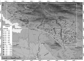
The vast size of the LoNAP study area (approximately 3000 square kilometres) led us to adopt an extensive, mixed survey strategy, based on motor vehicle survey combined with field-walking. Many low-mounded sites (even small tells of up to 0.2 hectares and with a relief of only 1 metre) and several flat sites (elevation 0–1 metres) were spotted on CORONA images thanks to the signature provided by anthrosols and confirmed on the ground (Menze and Ur Reference Menze and Ur2012). Intensive off-site field survey by means of transect walking will be used in the next field campaigns to survey intensively the upper part of the Zagros foothill rolling plains (Fig. 3, 500–700 metre altitude belt), where the analysis of remotely sensed images has proven to be largely ineffective due to countless low hillocks which are often easily confused with archaeological mounds. Similar approaches will be adopted in the environs of the largest sites, such as Ger-e-pan, Jerahiyeh, Tell Jamma Resh, Tell Gomel, Asingrian, Tell Amiyan and others (Fig. 3, sites no. 225, 1, 356, 40, 285, 29) with the aim of identifying the possible presence of sites not recognized through other techniques, to register field scatters and more thoroughly explore ancient land use (soil and water exploitation) and communications (hollow ways). A goal of intensive survey work is also to understand the degree to which results of non-intensive examination can skew the reconstruction of regional settlement, particularly with regard to small-sized sites belonging to the lower settlement hierarchy and to earlier periods, which can be deeply buried and concealed by later overburden, thus dramatically impacting understanding of prehistoric periods and the assessment of their settlement patterns.
Preliminary distribution of archaeological sites discovered in the 2012 and 2013 survey campaigns. © LoNAP

During survey, settlement sites and their boundaries were identified on the basis of three parameters: the presence of organic anthrosols, concentrations of archaeological finds and mounding. All surface ceramic collections and ground observations were recorded with a handheld Global Positioning System (GPS) receiver (Trimble Yuma Tablet) and integrated into a Geographic Information System (ArcGIS 10.1) spatial database. All settlements identified have been collected by means of full area coverage, using collection areas determined on the basis of topography. The corners and significant points on the boundaries of each unit have been visibly marked and their positions recorded via GPS in order to allow for the reconstruction of the site areas during different settlement occupation periods. The determination of occupation periods was based upon gathering diagnostic sherds (rims, bases, decorated body sherds) based on a ceramic typology established by Wilkinson and Tucker within the Iraqi ‘North Jazira Survey’ (Reference Wilkinson and Tucker1995) and later integrated by Ur (see Gavagnin, Iamoni, and Palermo Reference Gavagnin, Iamoni and Palermoin press). The Eastern Khabur Archaeological Survey, LoNAP, the Upper Greater Zab Archaeological Reconnaissance, and the Erbil Plain Archaeological Survey all use this common typology in order to achieve homogeneous—and thus fully comparable—dating for sites across this vast region. (DMB)
Natural and archaeological landscapes of the Land behind Nineveh: preliminary results
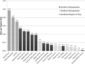
The 2012 and 2013 LoNAP survey campaigns led to the identification and ground truthing of 493 archaeological sites, 281 of which have yielded surface pottery and/or lithic assemblages and can be classified as habitation sites.Footnote 11 As may be seen from Fig. 4, the preliminary settlement density recorded in the LoNAP region is extremely high (0.70 sites per square kilometre). Together with the density documented by the Erbil Plain Archaeological Survey (EPAS: Ur et al. Reference Ur, de Jong, Giraud, Osborne and MacGinnis2013) in the Gwer and Qasr Shemamok regions, the evidence from the Land behind Nineveh is significant when compared to the other surface surveys conducted in both northern and southern Mesopotamia.Footnote 12 It shows vividly the great archaeological richness of this specific region—and, more generally, of the piedmont plains of Iraqi Kurdistan, as well as the extraordinary potential and heuristic possibilities of satellite imagery for archaeological landscape research.
Comparative site densities/recovery rates for Mesopotamian surveys, courtesy of J. Ur (based on Adams Reference Adams1965, 1981, Adams and Nissen Reference Adams and Nissen1972, Gibson Reference Gibson1972, Wright Reference Wright and Adams1981, Monchambert Reference Monchambert1984, Wilkinson Reference Wilkinson1990, Wilkinson and Tucker Reference Wilkinson and Tucker1995, Eidem and Warburton Reference Eidem and Warburton1996, Geyer and Monchambert Reference Geyer and Monchambert2003, Ur Reference Ur2010, Menze and Ur Reference Menze and Ur2012, Ur et al. Reference Ur, de Jong, Giraud, Osborne and MacGinnis2013)

A significant portion of the region explored by LoNAP is occupied by the foothills of the Zagros Mountains (1230 square kilometres, 42 per cent of the total area), an area only partially accessible due to the presence of numerous minefields and widespread unexploded ordnance. Visits made to the area, in particular in the Atrush (Upper Gomel) valley, made clear that the mountainsides are dotted with dozens of caves and rock-shelters.Footnote 13
The greatest density of ancient settlement in the Transtigridian piedmont plains is concentrated on Navkur (Fig. 3), the “plain of mud” in Kurmanji, a vast, almost level triangular plain in the eastern part of our survey area, about 30 kilometres at its widest, flanked to the north by the line of the Zagros foothills and to the south-west by the prominent outcrop of Jebel Maqloub (Reade and Anderson Reference Reade and Anderson2013: 69). The plain is well-watered by the River Al-Khazir, a major tributary of the Greater Zab, and the minor Nardush and Gomel rivers that join the Al-Khazir at the southern end of Navkur. Dozens of wadis feed these main watercourses and there are many abundant springs, making Navkur an intensively cultivated area, where cereals are grown (mainly wheat and to a much lesser extent barley, as well as rice), and fruit and vegetables.Footnote 14 The north-south axis of the River Gomel and the lower part of the plain constitute the backbone of the ancient occupation of Navkur. Many sites are arrayed in a linear fashion along the Gomel's banks, whilst a smaller number of sites are located along the Nardush and Al-Khazir. This is probably due to the higher flow rate of the Al-Khazir, which has a larger valley and a wider, meandering bed. Along its banks many modern gravel pits are located. The widespread extraction of gravel from the Al-Khazir riverbed, used directly as a building material and for the production of cement blocks, has certainly destroyed or extensively damaged numerous ancient sites on its banks. There is urgent need for recording, monitoring and conservation of sites along the riverbanks in Navkur, particularly in the Al-Khazir basin.
The plains of the piedmont belt in the western part of LoNAP, in the areas of Sumel, Dohuk, Ger-e-pan-Faideh, Al-Qosh, Ba'dreh and Sheikhan/‘Ain Sifni along the line of the Zagros foothills, are a further main (though considerably less significant) focus of settlement. Compared to Navkur, the physiographic and hydrographical situation of these foothill plains is less favourable, since they possess shallower soils, are crossed by wadis and are watered only by two significant permanent watercourses flowing westwards into the Tigris: the Rubar Dohuk and the Wadi Bandawai. The region benefits from suitable agricultural soils, mainly “Brown Soils (Deep Phase)” and locally “Reddish-Brown Soils (Deep Phase)”, which, in the presence of sufficient rainfall, can produce rich yields (Buringh Reference Buringh1960: folding chart). Mean annual rainfall in the LoNAP region is from 450 to 600 millimetres per year, dropping to 300–450 millimetres in drought years (Buringh Reference Buringh1960; Guest Reference Guest1966, figs. 5–6; Wirth Reference Wirth1962, Abb. 9–10). Cereals can therefore be cultivated using a dry-farming system, which is also locally enhanced by irrigation, particularly in the water-rich plain of Navkur, where various kinds of fruits and vegetables are grown.
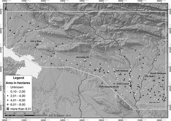
The combination of deep fertile soils and abundant water is certainly the main reason why human occupation has always been dense in the larger Transtigridian plains between Sumel-Dohuk in the west and Navkur in the east, where most of the larger sites are also located (Fig. 5): six of the eight settlements that cover more than 8 hectares are concentrated in the Navkur plain.Footnote 15 Just two large sites, Ger-e-pan (no. 225) and Jerahiyeh (no. 1), are located in the western piedmont plains, respectively at the southern end of the Ger-e-pan Plain, between the high ground of Jebel Zawa to the north and Chiya-i Dekan to the south, and in the Ba'dreh Plain on the small Rubar Dashqalan watercourse.
Preliminary assessment of settlement size classes. © LoNAP

Notwithstanding their agro-pastoral potential, however, the Transtigridian plains were not home to widespread urbanism and the size of archaeological sites remains limited throughout their occupation history. The most extensive site, Tell Gomel, with an area estimated at around 20 hectares, is not remotely comparable with the enormous cities of 100 hectares and more known from the adjacent Iraqi and Syrian Jezirah (for a summary see Ur Reference Ur2010: 152, tab. 8.1. and fig. 8.2.) and, further south, on the Erbil Plain (Ur et al. Reference Ur, de Jong, Giraud, Osborne and MacGinnis2013). In an early stage of our project we identified the principal (although not necessarily the only) cause of the lack of such urban growth as the fact that the Transtigridian plains lay within the hinterland of Nineveh, which from the second half of the fourth millennium b.c. onwards was an important urban centre that controlled the Upper Iraqi Tigris and the nearby piedmont plains (Morandi Bonacossi Reference Morandi Bonacossi2012–2013: 189–91, and in press a). It seemed plausible that Nineveh's urban growth from proto-historical times would have inhibited the emergence of comparable settlements in the immediate environs. However, an analysis of CORONA images of the plain surrounding Mosul, located directly to the south of the region investigated by LoNAP, has shown that several large urban centres are to be found in the immediate environs of Nineveh (Savioli Reference Savioliforthcoming), suggesting that no “friction factor” inhibiting the development of significant urban centres existed. The lack of urbanism in the LoNAP region has probably more to do with the rather isolated position of the Transtigridian piedmont belt in the very north of the Assyrian core area, the absence of major trade routes crossing the region, and perhaps its agricultural resources may have been less abundant than those in closer proximity to Nineveh.
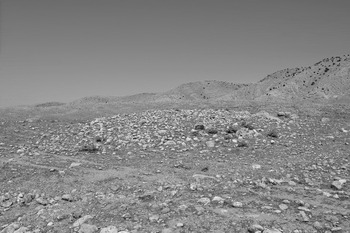
The first two LoNAP survey seasons have also gathered interesting evidence concerning a distinctive and extremely localised archaeological landscape, which has so far been isolated only in the upper regions of the Transtigridian foothill plains (500–600 metres altitude belt, Fig. 3). At the foot of the east-west oriented Chiya-i Dekan hills and the Jebel Al-Qosh and Chiya-e Zihera mountain ranges, high concentrations of cairns have been located. These tumuli may mark the burials of the pastoral nomadic groups known from cuneiform and later sources, but in the absence of excavation caution is required (Morandi Bonacossi in Reference Morandi Bonacossi, Lawrence, Altaweel and Philippress b).Footnote 16 Cairn fields dot the piedmont belt between the village of Dekan, a few kilometres east of Faideh, and Wadi Bandawai for a distance of nearly 6 kilometres along the Chiya-i Dekan slope deposits (Fig. 3, sites 444–461), indicating the existence in this area of extensive pastoral necropolises (Fig. 6). The cairn fields continue east of Wadi Bandawai towards the modern town of Al-Qosh and cover the slope deposits at the base of the mountain range of the same name. Several tumuli appear to have been looted, even in recent times. For instance the tumuli of the cairn field to the south of the village of Dekan Kabir have been systematically plundered by the villagers in recent years (site 458). Only the excavation of a significant sample of cairns will provide us with a chronological setting for these cemeteries.Footnote 17
Cairns in the Chiya-i Dekan piedmont plain (site 453). © LoNAP

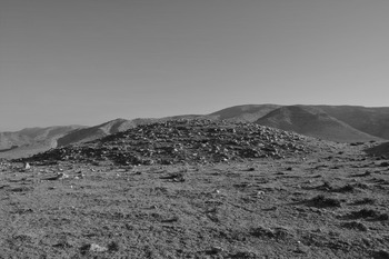
A particularly interesting cairn field (site 241) has been discovered on the same east-west axis as the Dekan-al-Qosh cemeteries, on a hilltop overlooking the modern road linking Sheikhan and Ba'dreh: a cluster of seventeen tumuli both large and small, some of which have been looted (Fig. 7). The ceramics littering the surface of this necropolis date exclusively to the Middle Bronze Age, thus possibly (but not necessarily) indicating that the cairns date to this period. These tumuli are clearly visible from the modern road running in the narrow valley at the foot of the hill, which probably follows an earlier route. The already well-known function of the tumuli as pastoral land-markers along the main overland communication routes within a tribal, pastoral landscape (Steimer and Braemer Reference Steimer-Herbert, Braemer and Guilaine1999: 178; Steimer-Herbet Reference Steimer-Herbet2004: 95–99; Charpin Reference Charpin, Ohnuma and Al-Khabur2010: 244; Morandi Bonacossi and Iamoni Reference Morandi Bonacossi and Iamoni2012: 52–53) can probably explain the location of this cairn field. Other larger cairn fields with dozens of funerary structures extending along the slope debris have been identified in the same valley, at the foot of the Chiya-e Zihera opposite cemetery 241.
Large tumulus of cairn field 241. © LoNAP

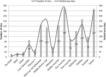
Fig. 8 illustrates the preliminary diachronic distribution of settlement in the Transtigridian piedmont plains of the Land behind Nineveh and the aggregate site area reconstructed.Footnote 18 The results of the first two survey seasons need to be integrated with additional information before any historical conclusions can be drawn. However, some preliminary observations on long-term occupation and land use processes may be made. (DMB)
Preliminary chart showing settlements and total settled area discovered in the 2012 and 2013 seasons. Numbers of sites (bars): left vertical axis; total settled hectares (line): right vertical axis. © LoNAP

The pre- and proto-historic periods
Current archaeological knowledge of Upper Mesopotamia concerning pre- and proto-historic times is somewhat uneven. The Upper Euphrates and Syrian Jezirah now offer a substantial number of case studies with regard to archaeological surveys and site excavations.Footnote 19 The Upper Tigris, on the contrary, is still noticeably lacking in up-to-date investigations.Footnote 20 Although a number of salvage excavations were undertaken during the 1980s prior to the construction of the Eski Mosul Dam, in only a few cases have these produced significant results in particular Kharabeh Shattani for the Halaf period (Watkins and Campbell Reference Watkins and Campbell1986; Baird et al. Reference Baird, Campbell and Watkins1995), Khirbet Hatara for the Ubaid and Late Chalcolithic (Fiorina Reference Fiorina1997 and Reference Fiorina2001), Tell Karrana 3 (Wilhelm and Zaccagnini Reference Wilhelm and Zaccagnini1993) and Mohammed Arab (Roaf Reference Roaf1984; Roaf and Killick Reference Roaf and Killick1987) for the final Late Chalcolithic and early third millennium b.c. None of these sites has, however, provided deep and complex stratigraphies with relative seriations of finds (especially pottery) that might have served as regional reference points. Further rescue excavations have been conducted by Iraqi archaeologists in the Ray Jezirah Project (RJP). These too furnished interesting data for the pre- and proto-historic periods (e.g. Khirbet Baguda and Khirbet Al-Akhwien, Tell Al-Dur and Tell Al-Uwaynat 15), but the lack of detailed publication has limited the impact of such investigations (Altaweel Reference Altaweel2006 and Reference Altaweel2007). As a result, the study of the material culture of the region must rely either on older excavations, e.g. Tepe Gawra (Speiser Reference Speiser1935; Tobler Reference Tobler1950; Rothman Reference Rothman2002), Arpachiyah (Mallowan and Cruikshank Reference Mallowan and Cruikshank1935), Nineveh (Campbell Thompson and Mallowan Reference Campbell Thompson and Mallowan1933; Gut Reference Gut1995), or on artefact seriations from adjacent areas, e.g. Tell Brak (McMahon and Oates Reference McMahon and Oates2007; McMahon Reference McMahon, Bonatz and Lutz2013) and Tell Hamoukar (Al-Quntar et al. Reference Al-Quntar, Khalidi and Ur2011) for the Late Chalcolithic periods. This has inevitable consequences for the identification of the ceramic diagnostics, especially for periods characterised by strong regional traditions (Gavagnin, Iamoni, and Palermo Reference Gavagnin, Iamoni and Palermoin press).
For relative chronology we follow the standard periodization for Upper Mesopotamia (e.g. Ur Reference Ur2010), but in view of the paucity of pre-Halaf finds recovered to date, we preferred for the present work to combine here all the ceramics into a single phase generally considered to precede the Halaf period (Early Pottery Neolithic and Hassuna/Samarra). The periodization of the early periods reflects actually a hybrid subdivision based on an old cultural-historical approach (Perkins Reference Perkins1949), followed by an updated relative chronology for the late fifth-fourth millennium b.c. Late Chalcolithic (Rothman Reference Rothman2001). Despite the employment of C14 determinations to correct the absolute dating of this periodization (Campbell Reference Campbell2007; Stein Reference Stein2012), it is quite clear that the system lacks internal coherence and homogeneity. It is hoped that the current projects in Iraqi Kurdistan will address this issue and help to provide a more consistent relative chronology for the region.
The pre-Halaf period: villages and seasonal occupation?
At present, the survey results show very limited occupation of the region under investigation in the pre-Halaf period, with only eight sites thus far identified (Fig. 8). This is somewhat surprising, especially given the very wide area surveyed so far and that the North Jazira Survey (henceforth NJS) indicates the presence of considerable regional settlement in this period (Wilkinson and Tucker Reference Wilkinson and Tucker1995). However, occupation in the Eski Mosul Dam region seems to have been more limited (Ball et al. Reference Ball, Campbell and Simpson2003: 9–10), and more in agreement with the LoNAP data. The total number of settled hectares seems to be very small, which suggests the occurrence of very small sites (the average number of settled hectares is slightly more than 0.5 per site), some of which may even represent seasonal occupation. But this pattern might have been affected by later and more substantial occupation that has reduced settlement visibility (see below for a discussion of this issue). Therefore, in absence of more intensive investigations based on off-site survey, these results must be considered as provisional. More intensive research carried out in key areas will help to provide a stronger body of evidence. (MI)
The Halaf and Ubaid periods: settlement expansion
The area shows an increase in settlement number during the Halaf period, apparently concentrated in specific areas, e.g. the Ba'dreh and Navkur plains (Fig. 8). The pattern may reflect the favourable environmental characteristics of the two areas. The number of sites is still small when compared with results from the NJS (Wilkinson and Tucker Reference Wilkinson and Tucker1995: 39–40; Wilkinson et al. Reference Wilkinson, Ur, Hritz, Wilkinson, Gibson and Widell2013: 37). However, data from the Tigris and Euphrates Reconnaissance Project (henceforth TERP) conducted in the Silopi province of Turkey suggest a similar pattern to that of LoNAP (Algaze et al. Reference Algaze, Hammer and Parker2012: 14–16). Population patterns in the Upper Tigris Valley and the Transtigridian plains seem to therefore vary, perhaps reflecting local trends the exact nature of which remains to be ascertained. The concentration of sites within specific areas seems to be a distinctive trait of the LoNAP region. In terms of occupied areas, the data show what may be a natural increase in settlement, with an average of less than 2 hectare per site, in agreement with evidence from both the NJS and the TERP (Wilkinson and Tucker Reference Wilkinson and Tucker1995: 40; Algaze et al. Reference Algaze, Hammer and Parker2012: 15–16). The Upper Tigris during the Halaf period was thus occupied quite uniformly by small villages in both the Tigris basin and the surrounding plains, with the modalities described above.
The settlement pattern for the Ubaid period is very similar. The number of sites continues to grow, though the increase is more moderate than in the preceding phase. In general, occupation seems to extend slightly beyond the areas occupied during the Halaf period. In contrast, the NJS shows the presence of a much higher number of sites, with the emergence of Tell al Hawa as a significantly larger site (Wilkinson and Tucker Reference Wilkinson and Tucker1995: 40–41) with an area exceeding 30 hectares (Ball et al. Reference Ball, Tucker and Wilkinson1989). The LoNAP survey has identified only small Ubaid settlements with an occupied hectare average even lower than that observed during the Halaf phase. This absence of size increase, though in agreement with TERP data (Algaze et al. Reference Algaze, Hammer and Parker2012: 17–18), is significantly different from what is known from other regions of Upper Mesopotamia, e.g. the Balikh Valley (Trentin Reference Trentin, Carter and Philip2010; Akkermans and Schwartz Reference Akkermans and Schwartz2003: 159–60). It suggests that it is in this period that the north and especially the eastern Upper Tigris area starts to follow autonomous trajectories that subsequently emerge more clearly, in particular during the Late Chalcolithic period (see below). Material culture does not seem to have local features, although a few ceramic types appear to show patterns in the painted iconography that might suggest local influences. Future research will seek to obtain a wider information base for the Ubaid period. (MI)
The Late Chalcolithic: a new model of settlement growth?
The Late Chalcolithic will be presented here as a single period because a substantial amount of pottery recovered remains unprocessed and the detailed periodization adopted in other studies (for example, Ur Reference Ur2010: Table B.1) is not yet possible. During the mid-to-late fifth and fourth millennia b.c. there is a tripling in the number of sites (Fig. 8), evenly distributed throughout almost all of the surveyed zones. In particular, the plain of Navkur has significant settlement with sites ranged along the major watercourses (River Al-Khazir and River Gomel), as well as on some minor tributaries. Sites are also located at some distance from water sources, probably evidence of the (by then widespread) ability to dig water-holes, a technique known to have been in use in Upper Mesopotamia since the late seventh millennium b.c./Hassuna period (Wilkinson and Tucker Reference Wilkinson and Tucker1995: 39). This profound change in settlement patterns has yet to be adequately explained. It seems possible however that the full occupation of the land, as well as the regular inter-site distance (usually about 5 kilometres, which would have facilitated contacts between settlements), may reflect economic concerns (e.g. commercial contacts, possibly for the acquisition of raw materials, previously little exploited) and demographic pressures. Although in the NJS region an increase in settlement number can be observed during the Late Chalcolithic (Wilkinson and Tucker Reference Wilkinson and Tucker1995: 44), which is in contrast with the pattern noted further north in the Cizre-Silopi area (Algaze et al. Reference Algaze, Hammer and Parker2012: 12–20), the estimate of settled area here shows, somewhat surprisingly, a reduction in the average number of hectares occupied. Although a differentiation in terms of site area among Late Chalcolithic sites is likely to have occurred too in the LoNAP area, the available data point to an apparent absence of a clear settlement hierarchy comparable with that developed in neighbouring regions. The Late Chalcolithic is known for the emergence in Upper Mesopotamia of massive sites, with dimensions exceeding 40–50 hectares, e.g. Tell Brak (Oates et al. Reference Oates, McMahon, Karsgaard, Al-Quntar and Ur2007; Ur et al. Reference Ur, Karsgaard and Oates2011), Hamoukar and the huge—but short lived—Khirbet al Fakhar (Al-Quntar et al. Reference Al-Quntar, Khalidi and Ur2011; Ur Reference Ur2010), Tell al Hawa (Ball et al. Reference Ball, Tucker and Wilkinson1989) and most likely Nineveh (Stronach Reference Stronach and Mazzoni1994). The preliminary data suggests that there is no evidence for the contemporaneous—and indeed sudden—emergence of large settlements in the LoNAP region pointing to the existence of an alternative, local model of urban formation in northern Mesopotamia. In this respect the almost total absence of South Mesopotamian ceramics in the region is potentially of great significance (see Gavagnin, Iamoni, and Palermo Reference Gavagnin, Iamoni and Palermoin press), suggesting very limited contacts between the two regions and further strengthening the possibility that processes of socio-economic complexity developed here along local trajectories, with a much higher degree of autonomy from the south than observed elsewhere in Upper Mesopotamia. A detailed study of the survey finds will improve our periodization of the Late Chalcolithic sites and allow an investigation of the origin of the dynamics of the Ubaid and early Late Chalcolithic. (MI)
Formation, preservation and visibility of prehistoric and proto-historic sites
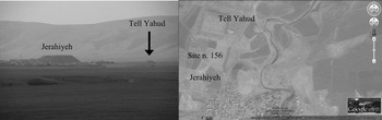
The preliminary data furnish a broad characterization of the archaeological landscape with reference to site formation, survival and visibility. The survey has detected, in at least three cases, the presence of clusters of smaller pre/proto-historic sites around major tells (usually with major occupations of the third-first millennia b.c.). An example is Jerahiyeh (Fig. 3, site 1), a mound of about 8.5 hectares which rises over the surrounding plain for about 40 metres (Fig. 9). The site has been known since the nineteenth century (Layard Reference Layard1849 : 33–34; 1853: 94–95). The recent work has demonstrated a long occupation, with traces of settlement dating to the Hellenistic, Neo-Assyrian and Middle Assyrian periods and the Middle Bronze Age. Sparse traces of pre- and proto-historic occupation were also found: these came from the very steep slopes of the mound, where significant erosion had exposed lower layers. North of the main mound, a markedly smaller site (Tell Yahud) cut by a modern road also furnished evidence of occupation dating to pre- and proto-historic times. Similar evidence, though pertaining to a much shorter period (probably just the Late Chalcolithic), was found in a neighbouring settlement (site 156) located a few tens of metres west of the main mound of Jerahiyeh.
The site of Jerahiyeh with nearby smaller mounds: Tell Yahud to the north of the main mound and site 156 (only visible in the satellite image) to the north-west (left photo taken in April 2013 © LoNAP, right satellite image Google Earth)

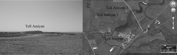
A comparable situation (though with site clusters a little more distant than those at Jerahiyeh) has been observed in the plain of Navkur in proximity to Tell Gomel (Fig. 3, site 40). Significant traces of occupation from Tell Gomel date to the second and first millennia b.c. and first millennium a.d. but earlier evidence has been recorded, thanks again to erosion, in this case of the western side of the mound. About 1 kilometre to the north, two smaller sites (nos. 475 and 476) on the eastern side of the river have evidence of proto-historic occupation. A further case of settlement clustering has been identified in the eastern area of the Navkur plain (Fig. 10). The site of Tell Amiyan (Fig. 3, site 29) covers an area of about 6 hectares, with the main settlement phase in the third and second millennia b.c. followed by significant first millennium b.c. occupation, as well as Parthian and Sasanian levels. Pre- and proto-historic periods are attested, revealed along the southern side of the mound by modern construction work exposing its lower (and inner) levels. The area around Tell Amiyan also contains two minor settlements (Tell Amiyan 2 and 3) of about 1 hectare each. Both sites are hardly visible in the plain (implying brief occupation) and are located north of the major mound. Tell Amiyan 3 shows traces of Late Chalcolithic and Ubaid occupation: its proximity to the main site corroborates the occurrence of site clustering as a feature of pre- and/or proto-historic settlements. Cyclic/sequential settlement is a model already identified elsewhere in the same area (Wilkinson and Tucker Reference Wilkinson and Tucker1995: 38–39 and 45–46; but see also Sabi Abyad for an excavated case study: Akkermans Reference Akkermans, Orthmann and Meyer2013a: 29–31). The data from LoNAP provides initial support for the model of neighbouring pre/proto-historic settlements. We cannot yet offer a more precise explanation for this phenomenon, though it is likely that the short-lived nature of many pre- and proto-historic sites is an important factor (Akkermans Reference Akkermans, Bonatz and Lutz2013b: 17–18). It seems to be a feature typical of fourth millennium b.c. settlements: future investigation by means of more intensive survey focussed on site clusters will attempt to gain a better understanding of the phenomenon.
Tell Amiyan with Tell Amiyan 2 and 3, respectively north-west and north of Tell Amiyan (left photo taken from Tell Amiyan 3 in August 2012 © LoNAP, right satellite image Google Earth)

Although a significant number of pre- and proto-historic settlements have been identified, a marked discrepancy between the numbers of sites recorded from different periods has emerged. This may depend on variations in regional settlement patterns for reasons that we are not yet able to ascertain (environmental factors, socio-economic reasons); however, site preservation and visibility are certainly key elements that must be taken also into account. Pre-Halaf and perhaps also Halaf sites on small low mounds might have been entirely destroyed by ploughing. This may be especially true in the case of small field divisions visible on aerial and satellite imagery, which may be subject to intensive ploughing and the turning of soil into slightly raised strips that can entirely destroy small flat prehistoric sites. Two case studies, Tell Gomel (discussed above) and Gir Kal, with significant occupation throughout the sixth–fourth millennia b.c. (Fig. 3, site 254), suggest that site visibility is also a factor relevant to the recognition of the earliest settlement phases. In both sites, however, the identification of pre/proto-historic occupation has been due to pure chance: erosion of the tell flanks by the River Gomel (on the west of Tell Gomel and the east of Gir Kal) has exposed the lowest and earliest occupation levels in both cases. Significantly, pottery collection from the site surfaces did not yield any diagnostic types for these phases. It is therefore to be expected that a number of small prehistoric sites have been destroyed by tilling and that others lie buried in the Navkur plain and adjacent survey regions, and that the occupation of the area during the late seventh–fourth millennia b.c. is destined to remain partially invisible. Future research will be focussed on the correction of this bias by means of intensive off-site survey in selected areas. (MI)
The Bronze Age and the emergence of an intensively ruralised landscape
After significant Late Chalcolithic settlement growth in the Transtigridian piedmont plains, the Ninevite 5 period is characterised by a marked drop in regional settlement, with less than half the number of settled sites (Fig. 8). These are scattered throughout the entire survey area, with a stronger concentration in the Navkur plain near water-sources. A similar general trend was also recorded in the NJS (Wilkinson and Tucker Reference Wilkinson and Tucker1995: 49–50, fig. 37 top), where the Ninevite 5 period marks the emergence of an initial settlement hierarchy. Substantial settlement dislocation and reorganization at the transition from the fourth to the third millennia b.c. are reported also from the Hamoukar (Ur Reference Ur2010: 104–06) and Leilan regions of north-eastern Syria (Stein and Wattenmaker Reference Stein, Wattenmaker and Miller1990). The nearby areas of the Cizre-Silopi Survey (Algaze et al. Reference Algaze, Hammer and Parker2012: 22–25, fig. 6), on the contrary, show a significant degree of settlement continuity with respect to the preceding Late Chalcolithic, suggesting the existence in Upper Mesopotamia of regionally and locally quite differentiated settlement trends. The reasons for these marked differences in demographic developments in contiguous regions have yet to be entirely understood, although the evidence gathered by LoNAP in the Transtigridian plains do not seem compatible with the hypothesis proposed by Algaze (Reference Algaze2005) and Algaze et al. (Reference Algaze, Hammer and Parker2012: 23–24), which suggests that the drastic reduction in settlement seen in several regions of Upper Mesopotamia in the early third millennium b.c. were in direct proportion to the intensity of contacts with Uruk societies during the preceding final Late Chalcolithic. In regions where during the Late Chalcolithic 4–5 phases there was greater interaction between local political entities and south Mesopotamian enclaves one might have expected a sharper decline in settlement in the late fourth/early third millennium b.c. after the demise of Uruk's presence in northern Mesopotamia. If this is consistent with the results of surveys in the Turkish and Syrian Upper Euphrates basin (Wilkinson Reference Wilkinson1990; Algaze et al. Reference Algaze, Breuninger and Knudstad1994) and the region covered by the NJS (Wilkinson and Tucker Reference Wilkinson and Tucker1995: 43–47, fig. 35), it is not with respect to the Transtigridian plains. Here, in fact, the surprisingly weak evidence of interaction between local Late Chalcolithic sites and intrusive Uruk settlements, such as Nineveh for example (Algaze Reference Algaze1986; Stronach Reference Stronach and Mazzoni1994), is not matched by a substantial continuity of settlement during the Late Chalcolithic/Early Bronze Age transition, but a drastic decline in occupation.
The second half of the third millennium b.c. saw a dramatic reversion of the occupation trend of our region, which is characterised by a striking flourishing of settlement and a fourfold increase in the number of occupied sites. A particularly distinctive development of the Transtigridian plains is the absolute lack of large expanding urban centres that absorbed surrounding villages, such as are typical of the mid-late third millennium b.c. settlement scenario of the Iraqi and Syrian Jezirah (for a summary see Ur Reference Ur2010: 152, tab. 8.1. and fig. 8.2.). This is the case, for example, in the NJS area, where the number of settled sites further dropped in comparison with the Ninevite 5 period, whereas the sites of Tell Al-Hawa and Kharaba Tibn underwent intensive urban expansion, which resulted in the extinction of the small surrounding satellite mounds (Wilkinson and Tucker Reference Wilkinson and Tucker1995: 51–53, figs. 37 top and centre, and 38). In place of the vigorous process of landscape urbanization that took place in the adjoining regions of Upper Mesopotamia, the LoNAP survey region has recorded the emergence of a ruralised landscape distinguished by a pervasive and dense system of small- and mid-sized rural sites. As mentioned above, the vicinity to Nineveh of the Zagros foothill plains may have been responsible for the lack of competing urban centres in the region immediately to the north of the city, and might instead have promoted the development of a weakly hierarchical network of agricultural villages and small towns as foci of its economic growth.
The Middle Bronze Age with its Khabur-pottery-dominated ceramic assemblage represents a further period of thriving occupation in the hinterland of Nineveh, when the region was part of the kingdom of Nurrugum (Charpin and Ziegler Reference Charpin and Ziegler2003: 97–99). During this phase settlement remains basically stable with 115 sites. Most of these were scattered in the Navkur plain or along the Zagros piedmont belt. Other minor clusters of Middle Bronze Age sites are located along the Wadi Bandawai, the wadi flowing below Ger-e-pan and the Rubar Dohuk. The dependence of habitation sites on available water resources is extremely evident in the settlement pattern of the region during the first half of the second millennium b.c.
After what seems a remarkable decline in settlement and population in the Mitanni period, a very sharp growth in settlement number characterised the Middle Assyrian epoch, when the number of occupied sites rose above the level of the preceding Middle Bronze Age (124 occupied sites). As already suggested by Mallowan (Reference Mallowan1947: 19–20), cultural and settlement continuity between the Middle Bronze Age and Middle Assyrian periods seems to have been very high in many regions of Upper Mesopotamia. Unlike the settlement and demographic trend recorded in our survey area, in the neighbouring Cizre-Silopi region (Algaze et al. Reference Algaze, Hammer and Parker2012: 31–33), the NJS (Wilkinson and Tucker Reference Wilkinson and Tucker1995: 59–60, figs. 37 bottom and 41 top) and the Eastern Syrian Jezirah (Bernbeck Reference Bernbeck1994; Morandi Bonacossi Reference Morandi Bonacossi1996; Donella Reference Donella2002; Anastasio Reference Anastasio2007; Tenu Reference Tenu2009; Ur Reference Ur2010) the number of settled Middle Assyrian sites seems to have remained significantly lower. This suggests that the areas located farthest from the core region of Assyria were characterized by less intense population growth dynamics. On the contrary, the proximity of our research area to the Assyrian capital of Ashur, and especially to Nineveh, a major centre for the cult of Ishtar in this period (Vieyra Reference Vieyra1957; Campbell Thompson and Mallowan Reference Campbell Thompson and Mallowan1932 and 1933; Beckman Reference Beckman1996; Reade Reference Reade2000: 407–09 and Reference Reade2005), may explain this flourishing of settlement in the northernmost region of the Assyrian heartland. The crowded Middle Assyrian occupation pattern, which laid the foundation for the later profound transformation of the region which occurred during the Neo-Assyrian period, clearly indicates a new interest in the northern plains of Assyria from the late fourteenth century b.c. onward, leading to a spatial shift of the ‘Land of Ashur’ from the Middle Tigris region around Ashur itself to the so-called ‘Assyrian Triangle’ and the foothill plains of the Zagros Mountains (see also Harmanşah Reference Harmanşah2012). (DMB)
The Iron Age and the planning of a new engineered Assyrian landscape
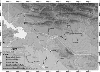
With its 189 settled sites identified so far, the Neo-Assyrian epoch represents the period of maximum expansion of human occupation in the region (Fig. 8). As observed also for the preceding periods, the largest concentration of sites clustered in the Navkur plain, an extremely densely occupied settlement pocket to the north-east of the last Assyrian capital cities of Khorsabad and Nineveh and a strategic cereal-producing region. Here the north-south alignment of the River Gomel became the principal axis of Assyrian settlement. The focus of occupation in the Gomel Valley and all of Navkur was the city-sized site of Tell Gomel. Neo-Assyrian occupation was also quite dense in the Sheikhan, Ba'dreh and Al-Qosh rolling plains and in the fertile plain of Ger-e-pan, possibly Assyrian Talmusa.Footnote 21 The preliminary site distribution obtained by LoNAP shows that the settlement pattern of a dense network of widespread small-sized sites (probably rural villages and isolated farmsteads) as recorded by previous survey projects in the western Assyrian homeland (Wilkinson and Tucker Reference Wilkinson and Tucker1995; Morandi Bonacossi Reference Morandi Bonacossi1996 and Reference Morandi Bonacossi and Bunnens2000; Wilkinson and Barbanes Reference Wilkinson, Barbanes and Bunnens2000; Wilkinson et al. Reference Wilkinson, Wilkinson, Barbanes, Ur and Altaweel2005; Anastasio Reference Anastasio2007; Ur Reference Ur2010 and in press), was also typical of the core region of the countryside near Nineveh.Footnote 22 The landscape of the study region and its settlement pattern were transformed enormously by the impressive irrigation system built by King Sennacherib astride the first Zagros foothills and the Transtigridian plains behind Nineveh (see above and Fig. 11). The recording through satellite imagery and ground survey of branches derived from the main canals (especially along the Khinis and Faideh canals) suggest that Nineveh's hinterland was intensively cultivated and that the hydraulic system was constructed to both supply the capital and to irrigate Nineveh's countryside in order to increase yield, reduce dry-farming risk across the piedmont belt of the Zagros foothills and to make this strategic and fertile region into one of Assyria's granaries.
Preliminary reconstruction of the surveyed Neo-Assyrian canals in the Nineveh hinterland. © LoNAP

Comparison between the Middle Bronze Age, Middle Assyrian and Neo-Assyrian settlement patterns in the LoNAP area reveals the fact that Assyria's appropriation and colonization of our region took place in the Middle Assyrian period, when the north Assyrian plains were incorporated into the realm, reconfiguring them politically, economically and ideologically (Harmanşah Reference Harmanşah2013). However, the Middle Assyrian colonization of the Transtigridian plains of northern Iraq did not result in the imperial imposition of a new settlement pattern, but rather consisted—after the Mitannian withdrawal—of the revitalization of the local traditional settlement network which was rooted in the Middle Bronze Age. In this region, the Neo-Assyrian period represented more a phase of intensification—albeit very strong—and spread of settlement and agricultural activity, rather than ex-novo colonization of the region. The northward shift of the empire's geographical, political and ideological core was maintained with the foundation of new capital cities at Dur-Sharrukin and Nineveh (see, most recently, Pedde Reference Pedde and Potts2012) and the building of the regional hydraulic system which changed fundamentally the economic basis of the region, transforming it from an extensive dry-farming area to a centrally planned imperial landscape based on intensive irrigation. The results of our survey emphasize that this process had its roots in the Middle Assyrian period, which increasingly appears to have been a crucial formative phase in the process of empire building.
Previous studies on the Assyrian regional canal network in the Land behind Nineveh (Oates Reference Oates1968; Reade Reference Reade1978 and Reference Reade, Al-Gailani Werr, Curtis, McMahon, Martin, Oates and Reade2002; Bagg Reference Bagg2000a and Reference Bagg2000b; Ur Reference Ur2005) and the preliminary results of LoNAP show that the making of an imperial multi-layered Assyrian landscape took place through the operation of a number of sophisticated mechanisms. The construction of this highly engineered landscape project substantially restructured this frontier zone and the adjacent territories, marking their imperial appropriation and transformation as part of the “Land of Ashur” not only through a programme of centralized landscape planning, but also by means of its ideological commemoration.Footnote 23 The latter was based on the targeted carving of commemorative rock reliefs and royal inscriptions in monumental complexes associated with the imposing hydraulic system, for example at Khinis, Jerwan, Shiru Maliktha, Faideh and Maltai (see, most recently, Morandi Bonacossi Reference Morandi Bonacossi2012–2013 and Reference Morandi Bonacossi, MacGinnis and Wickein press a), with the aim of reshaping the natural landscape so as to create a new symbolic Assyrian landscape and a new shared Assyrian memory.
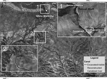
Although this is not the place to present detailed results of the on-going surveying, mapping and piecing together of the Assyrian regional canal system by LoNAP, we report briefly on two minor discoveries. David Oates identified a massive earth-built channel between Wadi Bandawai and Wadi Al-Milh, the so-called Bandawai canal (Fig. 11) (Oates Reference Oates1968; Reade Reference Reade, Al-Gailani Werr, Curtis, McMahon, Martin, Oates and Reade2002), which carried water to the Tarbisu/Sharif Khan canal (Oates Reference Oates1968: 49–52; Reade Reference Reade, Al-Gailani Werr, Curtis, McMahon, Martin, Oates and Reade2002; Ur Reference Ur2005: 330–35). However, the exact location of the canal head where the water of the Wadi Bandawai was diverted into the canal had not been identified (Fig. 12).Footnote 24 The beginning of the large earth canal is located at a higher altitude than the watercourse itself and the area of the probable canal head at Shiru Maliktha situated 4.5 kilometres upstream, at the point where the Wadi Bandawai emerges from the gorge immediately to the north of the modern village of the same name. It is not yet clear how the Assyrian engineers brought the water from the lower level of Shiru Maliktha along the water course to the higher one of the great Bandawai canal. Immediately to the north-west of the latter, a new canal stretch with a width of approximately 40 metres has been identified by LoNAP. The junction of the great Bandawai canal and the newly discovered one has been destroyed by the construction of the modern asphalted road leading to Bandawai village.
The Bandawai canals (centre) and the Shiru Maliktha rock relief and tunnel (top). CORONA 1039-2088DA032-2 and 1039-2088DA033-2 (February 28 1967) and DigitalGlobe, GeoEye (2014 Esri)

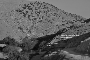
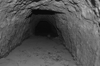
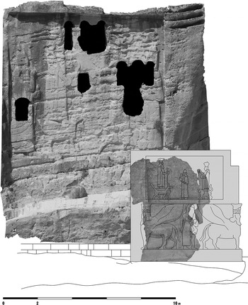
At Shiru Maliktha an unglamorous, badly preserved and still not entirely understood rock-cut niche (Fig. 13) has been known since the last century (Al-Amin Reference Al-Amin1948: 186–89; Shukri Reference Shukri1954: 92–93, pls. 5–8; Reade Reference Reade, Al-Gailani Werr, Curtis, McMahon, Martin, Oates and Reade2002). The relief representing an unknown Assyrian royal figure facing right beneath divine symbols, generally identified as Sennacherib, is carved at the back of a larger wedged-shaped niche cut into the hillside and is thought to have been connected with the Assyrian hydraulic works downstream of Bandawai village. A double row of circular pits, some of which perhaps held the wooden posts or pillars of a columned building, surrounds the niche (Reade Reference Reade, Al-Gailani Werr, Curtis, McMahon, Martin, Oates and Reade2002: 309–13). This commemorative complex was associated with the exit of a tunnel, the beginning of which has not yet been traced, hampering understanding of its exact function. Field survey conducted during the 2013 LoNAP season led to the discovery of a shaft close to the course of the Wadi Bandawai, about 600 metres upstream of Shiru Maliktha. The clearing of the shaft revealed that it gave access to an underground water tunnel which probably took water from the river at a short distance from the shaft itself (Fig. 14), where the tunnel entrance is in all probability located, and channelled it to the tunnel egress situated beside the Shiru Maliktha niche, more than half a kilometre downstream. Future fieldwork based on small test-trenches and geophysical survey is expected to reveal the tunnel's subterranean course and origin.
View of the Shiru Maliktha niche and the tunnel. © LoNAP

View of the Bandawai water tunnel (note the river sediments deposited inside). © LoNAP

The Shiru Maliktha carved niche was probably meant to commemorate this important technical achievement, similar to that of the Bastora Çay underground canal built by Sennacherib to supply Arbail with water (Safar Reference Safar1946 and Reference Safar1947; Ur et al. Reference Ur, de Jong, Giraud, Osborne and MacGinnis2013: 104) and the Neghub tunnel, which was part of the patti hegalli canal constructed by Ashurnasirpal II that provided Kalhu with water (Davey Reference Davey1985).Footnote 25 The construction of the Bastora Çay channel (partly underground) was commemorated by a royal inscription of Sennacherib, which was unfortunately stolen in 1990 (Ur et al. Reference Ur, de Jong, Giraud, Osborne and MacGinnis2013: 104). At the monumental complex of Khinis, the construction of a tunnel, by which Sennacherib's water course passed through a spur of rock, was celebrated through the carving of two rock-steles at the entrance and exit of the underground canal.Footnote 26 All the rock-cut commemorative monuments mentioned here exemplify a very typical topos of Assyrian royal rhetoric: innovative and thus symbolically charged technologies and technical achievements were part of the wide array of instruments used by Assyrian royal power to shape and memorialize a newly created landscape, and celebrated by the carved monuments (Harmanşah Reference Harmanşah2013).
Besides the construction of massive state-sponsored regional canal networks that supplied water to the Assyrian capitals, major provincial centres and their hinterlands, the Neo-Assyrian empire also created infrastructure for the purpose of facilitating river navigation and the transport of goods and materials. The building of these structures, which is described in cuneiform sources and depicted in Assyrian palace reliefs, is much less known from an archaeological perspective. Important new evidence comes now from the Land behind Nineveh, where the joint action of heavy winter rainfall and bulldozer-quarrying the Gomel riverbed for gravel has exposed an almost 30 metre long stone quay-wall running along the right river bank, opposite the village of Zinawa Ghazi (Fig. 11; Morandi Bonacossi Reference Morandi Bonacossi, Gaspa, Greco, Morandi Bonacossi, Ponchia and Rollinger2014). The quay, which represents the first extra-urban archaeological evidence that can be related to the use of the rivers of the Assyrian core region as waterways, probably dates to the Neo-Assyrian period judging from the building technique and materials used, which resemble those found in the Jerwan aqueduct. The possible presence of a second Neo-Assyrian quay on the larger Al-Khazir River (unfortunately destroyed by extensive gravel quarrying activity, Morandi Bonacossi Reference Morandi Bonacossi, Gaspa, Greco, Morandi Bonacossi, Ponchia and Rollinger2014: 452) suggests that river transport was extensively used, not only on the major streams such as the Tigris and the Upper and Lower Zab, but also on the network of seasonal watercourses of the Land behind Nineveh, and was developed through the widespread creation of suitable infrastructure.
The transformation of the region into an irrigated, intensively cultivated and highly productive landscape through the building of an impressive branched network of canals—which, due to their size, were suitable for navigation—has important implications for understanding the nature of the Neo-Assyrian staple economy. Canals as transport infrastructure (Ergenzinger et al. Reference Ergenzinger, Frey, Kühne, Kurschner, Bintliff, Davidson and Grant1988; Ergenzinger and Kühne Reference Ergenzinger, Kühne and Kühne1991; Fales Reference Fales and Kühne2008) and rivers equipped with stone quay-walls for navigation and transport (Fales Reference Fales, Zabłocka and Zawadzki1993; Morandi Bonacossi Reference Morandi Bonacossi, Gaspa, Greco, Morandi Bonacossi, Ponchia and Rollinger2014) would have made the shipping of large quantities of staple foodstuffs, in particular cereals, to Nineveh and the other major urban centres of the Assyrian core along the Middle Tigris particularly easy and convenient. (DMB)
The rural landscape in the Land behind Mosul
The planning of a multi-layered imperial landscape through the creation of a regional hydraulic system interlinked with commemorative monuments imprinted the landscape of northern Assyria with such a profound structural and ideological signature that it influenced settlement patterns in the region long after the fall of Nineveh. After the collapse of the Assyrian empire and a period of settlement reduction in the Post-Assyrian period (Fig. 8), a still elusive phase from the viewpoint of ceramic diagnostics also in the LoNAP survey area (Gavagnin, Iamoni, and Palermo Reference Gavagnin, Iamoni and Palermoin press), the Hellenistic period is distinguished by a strong recovery of settlement and the re-colonization of many Assyrian sites.Footnote 27 In the eastern Upper Iraqi Tigris plains of Dohuk, Faideh, Al-Qosh, Ba'dreh and Sheikhan in particular, the Assyrian settlement system seems thus to have determined the pattern of rural occupation for the rest of the first millennium b.c., whilst the Navkur plain shows a lesser degree of continuity with the Assyrian period.
During the Parthian period our region witnessed a second peak in occupation, when the region was part of Adiabene, a vassal kingdom of the Parthian empire (Marciak Reference Marciak2011).Footnote 28 In the following Sasanian epoch, however, there is clear evidence of significant settlement reduction, an occupation trend that has also been observed—though with a less marked decrease—in the NJS area (Wilkinson and Tucker Reference Wilkinson and Tucker1995: fig. 45 top; Simpson Reference Simpson, Bartl and Hauser1996).
The Islamic period remains largely unexplored in northern Iraqi Kurdistan. The written sources relating to the LoNAP region are essentially limited to Mosul and its immediate hinterland. Only a few villages east of Mosul are mentioned in medieval sources, such as Karmalis, Bartalla and Bashika, as active markets through which the rich agricultural production of the region flowed (Le Strange Reference Le Strange1905). Mosul, with an area of almost 300 hectares, seems to have been a thriving urban centre in the Abbasid period (Ashtor Reference Ashtor1976: 89; Robinson Reference Robinson2004). In our survey region only the site of Maltai, today incorporated into the western outskirts of Dohuk, appears to have deserved some mention in the texts of medieval travellers and geographers for its lush orchards, vineyards and hemp plantations, but also for the extraction of coal (Le Strange Reference Le Strange1905). The Transtigridian plains of northern Kurdistan may have played the role of a large productive, cereal-growing hinterland of Mosul and Balad, as they did earlier with Nineveh. In general, however, long-term decline in agricultural production and population is documented in Upper Mesopotamia by the records of the kharaj, the Islamic land tax (Ashtor Reference Ashtor1976: 63, 173; Wilkinson and Tucker Reference Wilkinson and Tucker1995: 73) with an only temporary recovery during the Ayyubid period (Ashtor Reference Ashtor1976: 230). Ottoman times were again an epoch of depopulation and rural-to-urban migration in Upper Mesopotamia (Lewis Reference Lewis1955; Hütteroth Reference Hütteroth1990). Along the Tigris, however, this decline appears to have been less intense (Wilkinson and Tucker Reference Wilkinson and Tucker1995: 73) and Mosul and other urban centres (like Balad/Eski Mosul) entered a phase of urban growth which distinguished the Abbasid, Ayyubid and also Ottoman periods. The thirty-five Islamic sites investigated during the Eski Mosul Dam rescue excavations on both banks of the Tigris attest to the dense settlement record of the river valley as opposed to the much sparser settlement of the adjacent Sinjar region (Wilhelm and Zaccagnini Reference Wilhelm and Zaccagnini1993; Wilkinson and Tucker Reference Wilkinson and Tucker1995: 71–74, fig. 45; Ball Reference Ball, Bartl and Hauser1996; Ball et al. Reference Ball, Campbell and Simpson2003; Simpson Reference Simpson2007). The pottery recovered during our survey from the numerous sites with Islamic occupation in the plains east of the Upper Iraqi Tigris still needs to be studied in depth in order to disentangle settlement patterns in the Early, Middle and Late Islamic periods in the Land behind Mosul.Footnote 29
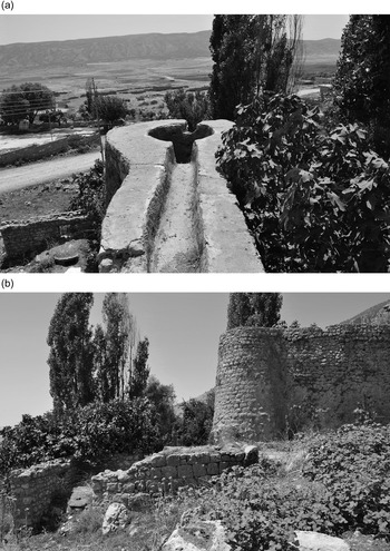
Among the non-habitation sites identified during the first two LoNAP seasons, particularly frequent and characteristic of the rural landscape of the late periods are stone “drop-tower” gristmills. Out of the thirty-four mills in varying states of conservation found to date during the survey, thirty-two are drop-tower gristmills and two horse mills, which were driven by working animals. Drop-tower gristmill technology appears to have been the leading milling technology in the region, probably because it was well adapted to the topography of the Transtigridian plains and their variable water supply. The mills were all situated on the region's permanent watercourses, such as the Rubar Dohuk, Wadi Bandawai, Rubar Dashqalan, River Gomel and the Nardush, a tributary of the Al-Khazir, which fed the canals supplying the mills with water. The drop-tower gristmills were water-powered grain-mills (Neely Reference Neely2011) that included a canal, which in its last stretch was stone-built and channelled the water to a masonry drop-tower supplying a head of water to drive the mill (Fig. 15). The tower consisted of a tall stone structure containing a large cylindrical holding-tank with an inner diameter of approximately 2 metres, from which the water fell, creating a force sufficient to drive the mill wheel and millstone. The water might then either be returned to the canal system and flow southward to the top of the next drop-tower, or be allowed to flow into the stream that fed the canal network. Sometimes the water was directed into small irrigation channels that watered orchards or fields.
a) Channel bringing water to the gristmill drop-tower (note the opening in the cylindrical holding-tank); b) channel, drop-tower and millhouse, Yekmala (site 315). © LoNAP

The best-preserved water towers survive to a height of 5–6 metres and had an internal structure of unworked medium-sized stones bound with mortar. The main (downstream) side of the towers is in most cases rectilinear (but can sometimes also be curved) and has always a revetment of well-fitted carefully dressed blocks of ashlar masonry, whilst the two lateral sides are curved and made with undressed stones. The mill house was located at the base of the drop-tower. The millstones, which were situated in the milling room in the upper floor of the mill house, were powered by means of a side-shot wheel mechanism, that is by water flowing through a hole in the drop-tower holding-tank into a subterranean room (the wheel room) located below the milling room. Here the water hit the upper edges of the wheel blades, thus driving the waterwheel in a counter-clockwise direction and powering the millstone by way of a gear mechanism (Neely Reference Neely2011: 240–43). The widespread employment of side-shot wheel technology in south-western Iran to northern Kurdistan and other regions of the Near East, such as the northern and southern Levant and North Africa, attests to its efficiency in certain environmental and topographical situations and diffusion over a large area of a shared technological know-how (Schiølor Reference Schiølor1989; Harverson Reference Harverson1993; Wilson Reference Wilson1995; Casana and Wilkinson Reference Casana, Wilkinson and Yener2005).
The chronology of these ubiquitous productive structures is difficult to ascertain without archaeological excavation. Many local informers reported that several drop-tower gristmills were still in use as late as the 1970s and 1980s. Of course substantial productive structures like these watermills may well have a long history and have been restored and partly rebuilt on older structures. A seminal study by James Neely (Reference Neely2011), based on a survey of more than twenty drop-tower gristmills in the Deh Luran Plain of south-western Iran, the excavation of one of them and comparative archaeological evidence from Iran, has shown that these structures were built early during the Sasanian period, used into the Early Islamic period and in some cases refurbished and kept in use until the last century.Footnote 30
Although a similar early origin for the gristmills of northern Kurdistan cannot be excluded, at this early stage in the project we prefer to tentatively place them in the Islamic period. A detailed study based on intensive survey and excavation of these watermills, their location, distribution, building technique and technology, in association with the reconstruction of land use patterns during the Islamic and Sasanian periods, will be an important future goal of LoNAP, which will improve the understanding of these extraordinary productive installations, their configuration within the region's rural landscape and their chronology. (DMB)
Conclusions and future work
The first two seasons of archaeological survey in the Transtigridian plains of the Land behind Nineveh in northern Iraqi Kurdistan have revealed a complex, multi-layered and extraordinarily rich archaeological landscape. The Navkur plain, with its fertile agricultural soils, as well as the river valleys of the Gomel and Al-Khazir, formed the focus of human occupation in the region since prehistoric and proto-historic times, whereas settlement in the plains crossed by perennial streams immediately east of the Tigris was less intense. The piedmont belts of the region under investigation, located at the foot of the first Zagros foothills, appear to have been intensively frequented by pastoral communities—evidenced to date only by numerous and extensive cairn fields not associated with other archaeological sites. Semi-nomadic pastoralism seems to have been an important aspect in the ancient and recent history of occupation and resource-use in the region. The finer definition of this important mobile component of the regional population in a diachronic perspective in future field campaigns will make necessary the use of dedicated survey methods and the excavation of selected burial cairns and any other pastoral sites identified, such as camps or enclosures for animals.
Following the first significant development of settlement in the Late Chalcolithic, the second half of the third millennium b.c. saw the emergence, in contrast with the adjacent regions of the Iraqi and Syrian Jezirah and the Erbil Plain (where the first large urban centres took shape), of a dense rural landscape, based on small-sized villages scattered throughout the plains of the Zagros foothills. Obtaining a more accurate picture of this idiosyncrasy of local settlement and cultural processes in the Land behind Nineveh from the Late Chalcolithic onwards will be one of the research objectives of LoNAP in following field seasons.
The gradual northward shift of the centre of the “Land of Ashur” from the Middle Tigris up to the ‘Assyrian Triangle’, which started from the Middle Assyrian period, marked the incorporation of the hinterland of Nineveh into the new imperial structure and the start of a complex political, socio-economic and ideological process of appropriation of this frontier territory, which, in little more than half a millennium, profoundly transformed the region. This included the foundation of new capital cities, first at Khorsabad and then Nineveh, and new provincial centres,Footnote 31 the arrival of new populations through the forced settlement of prisoners-of-war deported mainly from the Levant and south-eastern Anatolia (Oded Reference Oded1979: 20–21, 28), the restructuring of the region's natural hydrology through the construction of an extensive system of canals to irrigate the Land of Nineveh and supply water to the capital, and the creation of monumental rock reliefs as symbols of royal power and its divine legitimacy. The result was a dramatic transformation of the landscape and its regional production bases, its social and political structure and collective memory.
These and other issues—such as Iron Age settlement intensification rather than ex-novo colonization—will continue to be investigated in the next research campaigns which will extend the survey to include the mountainous region of the first Zagros foothills. Here the numerous caves and rock-shelters will be explored with the aim of verifying the existence of Palaeolithic, Epipalaeolithic and Pre-Pottery Neolithic sites of mobile pastoral occupation. In addition palaeoenvironmental archives will be used to investigate the evolution of the region's ancient climate and environment including natural climatic fluctuations and the impact of human activity. There will be an extension of intensive survey work around major sites identified during previous campaigns through remote sensing and extensive field walking, with the goal of locating smaller sites that have so far escaped identification due to the masking effect of subsequent archaeological overburden. In addition, an open-area excavation in the central site of Tell Gomel in the Navkur plain will be started to provide reliable sequences of archaeological materials covering a wide time span, from the Ubaid/Late Chalcolithic to the Ottoman periods. This will allow the development of regional reference sequences and the fine-tuning of our understanding of settlement and land use patterns revealed by the survey. Finally, the study of the great Assyrian regional hydraulic system will continue, with the excavation of geo-archaeological test-trenches in selected channels in order to reconstruct their geometry, flow, impact on the region's agricultural production system and abandonment processes.
In the coming decades, the economic and cultural development of Iraqi Kurdistan will be enriched by the protection and enhancement of its extraordinary cultural heritage. In this strategic context, LoNAP will continue to make its contribution through assisting with the design and establishment of an archaeological and environmental park focused on the regional Assyrian hydraulic system. This will ensure the conservation and sustainable management of the outstanding rock monuments of figurative art at Khinis, Shiru Maliktha, Faideh and Maltai and the Jerwan aqueduct connected to it, and the entire cultural landscape of the Nineveh hinterland (Fig. 16). (DMB)
3D laser scanner model of the “Large Panel” relief and the sculptured monolith at the head of Sennacherib's Canal at Khinis (Roberto Orazi, “Project of Conservation and Management of Sennacherib's Irrigation System” – Institute for Technologies Applied to Cultural Heritage, National Research Council, Rome)