The British Fisheries Society was a national improvement scheme backed by major Highland landowners that, through the establishment of planned fishing villages, was to provide permanent work and housing for the rural poor displaced by the widespread agricultural reforms that transformed the Scottish Highland landscape through the eighteenth century.Footnote 1 The British Society for Extending the Fisheries and Improving the Sea Coasts of the Kingdom of Great Britain, to give it its full name, was a quasi-governmental body incorporated as a joint-stock company by Act of Parliament in July 1786. The Act followed a period of quick lobbying by the Highland Society of London in response to the 1785 Fishery Act which, through changes to the bounty regulations, permitted large offshore fishing busses, which dominated the herring fishery, to buy directly from small boats. Throughout the early modern period a succession of parliamentary Acts were passed by Scottish, English and, post-1707, British governments determined to encourage the expansion and promotion of the fisheries to increase the national wealth. It was the British government's ambition to mount a large-scale, offshore herring fishery capable of rivalling the Dutch.Footnote 2 The geographer James R. Coull writes that
from the late seventeenth to the early nineteenth centuries the promotion of the fishery was seen as a proper field for government financial incentives, policy was for long dominated by the objective of increasing exports: this was done by giving export bounties and by exempting from the heavy salt duties salt which was to be used for curing herring for export.Footnote 3
However, despite its name, the British Fisheries Society was much more closely concerned with agricultural improvement and the management of the subsequent social and economic change within the Scottish Highlands than the national fisheries. The significance of the 1785 Fisheries Act for the group of Highland landowners who founded the British Fisheries Society was that by letting inshore boats sell directly to offshore busses it provided a legislative opportunity for economic development in the Highlands as an inshore fleet of small boats made planned coastal villages a real possibility.Footnote 4 New fishing settlements were seen as a means of regional development in the Highlands and the aims and activities of the British Fisheries Society were therefore part of the much longer process of transformation in the Scottish rural economy.Footnote 5 The eighteenth century saw the economy and culture of the Scottish Highlands transformed from that of a pastoral society centred upon the social and economic structure of the clan system into an early modern, ‘improved’ commercial agricultural economy defined by soaring land rents and the removal of traditional settlements and communities to make way for more profitable sheep walks. This process permanently altered the physical appearance and social structure of the Highlands. One of the agents of this change was the establishment of planned villages.
The process of transformation, which began in the late seventeenth century, was driven by the gradual evolution of the traditional paternalistic role of the clan chieftain into that of a commercial landlord.Footnote 6 Agricultural reforms were underway throughout the Highlands by the 1750s; however, early reforms were principally aimed at the established large tenants, the tacksmen, who had traditionally paid a low rent in lieu of military service, and other duties, to the clan chief. The settlements of ordinary Highlanders were still by and large unaffected by the economic transition underway.Footnote 7 In the mid-eighteenth century most of the Highlands were still peppered with thousands of traditional bailtean settlements (the typical bailtean was a semi-permanent settlement of 10 to 20 dwellings clustered closely together in an irregular manner). Yet, by the 1760s and 1770s, bailtean were being removed to make way for high rent paying cattle and sheep ranching. By 1802, bailtean had been erased from Perthshire, Dumbarton-shire, Argyll and the entire West Highland coast, from Oban to Loch Broom: all had been placed ‘under sheep’.Footnote 8 Faced with land enclosures, poverty and unprecedented population growth the period has been described as ‘an alarming time for the common people, a time of communal anxiety and insecurity’.Footnote 9 In the nineteenth century the brutality of forced Highland Clearances brought infamy to the process of enclosure and resettlement. However, in the later eighteenth century the Highland landlord did not seek to remove people entirely, only to less productive and less profitable land, and many deplored the depopulating effect of the ‘evil of emigration’.Footnote 10 The late eighteenth century is described by Eric Richards as the ‘Classic Age’ of the Highland Clearances, when an attempt was made to save and develop the Highlands and its population in a new modern model prior to an admission of failure and the total capitulation to sheep in the nineteenth century.Footnote 11 Planned villages were to be the centres of new non-agricultural industries, such as the herring fishery, part of a new type of dual-economy estate functioning profitably alongside large-scale sheep ranching.Footnote 12 In terms of settlement patterns, the contrast between the irregular cluster of the bailtean and the ordered geometry of the grid-plan village could not be greater: the former very much of its place, the latter designed, ordered and imposed.
The Highland planned village movement
‘The entire history of the modern Highlands is pockmarked with broken schemes for development, with dreams of economic growth, fishing, manufacturing, mining, villages and new rural enterprises, mainly dashed by the problems inherent in the region's geographical disadvantages.’Footnote 13 However, in the eighteenth century the planned village was viewed as the ‘focus par excellence’ of the dual-economy estate.Footnote 14 The geographer David Turnock has observed that, ‘like the model of agricultural improvement the planned village formula offered security and advantage to all . . . with careful promotion some of the projects were enormously successful and developed into true urban communities but there were others which failed to gain any momentum and did not grow beyond the level of a small rural settlement’.Footnote 15 The planned village movement in the Highlands was a remarkable building boom for a region with only a handful of permanent towns and villages at the beginning of the eighteenth century, particularly given that the majority of villages were founded in the brief period 1780–1850. Across Scotland, Douglas Lockhart has estimated that over 500 planned villages were founded during the long eighteenth century.Footnote 16 In a separate study Lockhart has further estimated that at least 91 were established in the Highland region.Footnote 17 This figure does not include a further 130 in the north-east region which contains considerable areas of the Highlands' eastern fringe.
Early planned villages in the Highlands followed three distinct models. The first Highland planned villages of the Age of Improvement emerged in the mid-eighteenth century. These were typical of the eighteenth-century model villages established throughout Britain as part of wider estate enclosure and improvement schemes. The first was the duke of Perth's grid-plan settlement at Crieff, 1731, but the most celebrated is Inveraray, Argyll, the seat of the dukes of Argyll. The old village of Inveraray was transplanted to the shore of Loch Fyne in 1751 from its former location adjacent to Inveraray Castle. The new Inveraray was a typical model estate village built to express architecturally the taste and grandeur of the House of Argyll. The 1751 cruciform-plan was designed by John Adam, brother and partner of Robert, and completed by the neo-classical architect Robert Mylne for the fifth duke of Argyll, 1770–1800.Footnote 18 The architectural elegance of Inveraray has been described as ‘without equal among small British towns’.Footnote 19 The aesthetic imperative which defines Inveraray was typical of the British model village and can be compared to other aesthetically driven examples such as Lord Dorchester's Milton Abbas, Dorset, 1773, designed by William Chambers (1723–96), or Harewood, Yorkshire, by John Carr (1723–1807), laid out in the 1760s.Footnote 20
Through the 1750s and 1760s the grand architectural statement of Inveraray was countered by parallel developments on the eastern margins of the Highlands where a different, utilitarian, village type emerged: industrial centres intended to be the catalysts for economic growth and the development of regional market economies.Footnote 21 In the north-eastern counties of Banff, Moray and Inverness-shire, a circle of improving landowners established villages not as personal architectural statements but as nascent centres for an anticipated regional textile industry. These villages were plain and practical places laid out on simple grid-plans on unimproved marginal land.Footnote 22 The north-east village was a particularly utilitarian form of town planning, which Spiro Kostof describes as the ‘practical model . . . factual, functional, cool, not in the least magical . . . the concept that motivates colonial towns and company towns’.Footnote 23 The first planned village in the north-east was New Keith, founded by the earl of Seafield, c. 1750: a grid-plan village centred upon linen manufacturing.Footnote 24 Perhaps the most successful and enduring was Sir Grant of Grant's grid-plan Grantown-on-Spey, Inverness-shire, laid out by the north-east surveyor Alexander Taylor, 1767, which won a prize at the Highland Society of Edinburgh.Footnote 25 The geographer Ian Adams identifies the north-east group of landowners and their shared pool of land surveyors as the influential North-East School of surveying and planning in Scotland.Footnote 26
At a national, British, level the establishment of villages in the Highlands also emerged as a matter of government policy in the 1750s. The first national programme for planned villages in the Highlands was established by the Annexed and Forfeited Estates Commission, 1752–84, in the aftermath of the Jacobite Rising, 1745–46. This was a shift in government policy in which ‘state sponsored terrorism gave way to state sponsored improvement’.Footnote 27 The commissioners were tasked by the government with the social and economic improvement of 13 of the largest Highland estates forfeited to the state by rebel Jacobite clan chiefs.Footnote 28 The post-Culloden mentality behind the commission meant that the commissioners were principally Scottish Whig non-Highland landowners, who served out of duty to the national interest, both Scottish and British. The commissioners were to have a ‘particular attention . . . to the enlargement, or new erection of towns and villages’.Footnote 29 Following the end of the Seven Years War, 1756–63, the commission's first settlements were populated with disbanded troops. Appropriately, the commissioners called these settlements coloniae after the Roman veteran settlements established to pacify conquered territory.Footnote 30 However, for the most part, the villages established by the commission were not a great success and it was decommissioned in 1784. Far from setting a civic example, the disbanded troops were found to be idle, violent and prone to drink and debt with a ‘wholly destructive’ influence upon regional development in the Highlands.Footnote 31 The sites were often chosen for their strategic location, at key loch heads and glen passes such as Kinloch Rannoch and Callendar, not for the agricultural or industrial potential of the site. Despite the commission's provision of housing settlers did not always settle: at Strelitz Coupar Angus, for example, 69 houses were built but only 9 settlers remained after 1764.Footnote 32 The money wasted on house building was a lasting lesson for those involved in the Highland planned village movement. Annette Smith neatly summarizes the Annexed Estates commission planned village programme as follows: ‘in its conception, the plan of providing for disbanded soldiers and sailors, increasing the population of the Highlands and Islands, importing necessary trades, and building houses of a higher standard than was usual, all in one step, was a splendid one. In its implementation, little can be said in its favour.’Footnote 33 Nonetheless, the commission played a ‘formative role in shaping the agenda for Highland improvement’ through the example set to Highland landowners.Footnote 34
By the later eighteenth century the memory of Culloden had receded and the British government's interests in the Highlands had principally turned to military recruitment and the growing need for new natural resources, whether slate, kelp, wool, hemp or fish. The loyalty and bravery of the new Highland regiments in the Seven Years War, 1756–63, had brought the Highland clansmen to the attention of the British Army as a vast resource of excellent and expendable troops. The Highlands were promoted by Whig polemicists, such as John Knox (1720–90), as an untapped natural resource which could supply the raw industrial materials and food produce required to maintain the factories and towns of the nascent Industrial Revolution in England and Lowland Scotland. It was a situation heightened by the British government's economic and political pain induced by the loss of the American colonies in 1783.Footnote 35 The government was therefore keen to support any private or public improvements in the Highlands that prevented emigration and increased economic productivity.
The British Fisheries Society
Following the demise of the Annexed Estates Commission in 1784, the establishment of the British Fisheries Society, 1786, was the next attempt on a national level to create a network of planned villages throughout the Highlands. By 1786 the Society's mandate for establishing planned fishing villages was to increase economic productivity in the Highlands and thereby to prevent emigration; it was not pacification. The composition of the Society's first Board of Directors reflects the change in national attitude towards the Highlands from one of suspicion to one of inclusion. The society's founding Board of Directors comprised the inner circle of the Scottish Whig political and landowning establishment; besides boasting John, fifth duke of Argyll (1723–1806) as chairman, the earl of Breadalbane was deputy chairman and other board members included the marquis of Graham, the earl of Moray, the earl of Abercorn and the earl Gower. To this august group can be added several members of parliament associated with Highland landownership, Improvement and the Scottish Enlightenment, such as Sir John Sinclair, Sir James Grant of Grant, Sir Henry Beaufoy, Sir George Dempster, Sir Adam Fergusson and Sir William Pulteney.
Andrew Mackillop has termed this type of close ‘improving’ relationship between Highland landowners and government that emerged in the later eighteenth century as ‘the patriotic partnership’.Footnote 36 For the landowner the patriotic partnership meant that estate improvement was not just a matter of personal profit but also a patriotic duty. Furthermore, it was also a duty to support and serve on government-sponsored bodies committed to Highland improvement such as the British Fisheries Society.Footnote 37 Like most landowners in Britain, the typical Highland landowner was, if not directly a member of the government through a cabinet position, then usually the member of parliament for their constituency. They also sat on government commissions relating to the Highlands and were involved in improving societies such as the Highland Society of London, founded in 1778, also chaired by the fifth duke of Argyll.Footnote 38 In the context of the Highlands, the activities of the dukes of Argyll, in both public and private, were central to the cause of Improvement. The House of Argyll set the standard with a programme of wide-ranging and innovative improvements to their Inveraray estates, such as the resetting of tenancies towards the amalgamation of small farms and the establishment of the new town of Inveraray. They also exerted considerable political influence through a favoured position with successive Whig governments. It is therefore not surprising that amongst his various improving activities the fifth duke of Argyll was the first chairman of the British Fisheries Society.
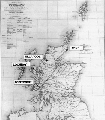
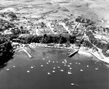
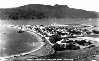
The British Fisheries Society established four villages along the coastline of the Scottish Highlands (Figure 1). Ullapool, Loch Broom, Wester Ross and Tobermory, Isle of Mull, were founded in 1788, Lochbay, Isle of Skye, 1790, and Pulteneytown, Wick, Caithness, 1808. Tobermory and Loch Broom both had established reputations amongst the Scottish fishing fleet for good harbours with safe anchorage.Footnote 39 Loch Broom was also famed for the size of its herring shoals and the Annexed Estates Commission had previously considered establishing a village there. The contracts for the purchase of both sites were exchanged on 28 February 1788.Footnote 40 The natural harbours and town plans of Tobermory and Ullapool can be seen in photographs of the two villages (Figures 2 and 3). Following the commencement of works at Tobermory and Ullapool, 1,000 acres at Lochbay, Isle of Skye, were purchased in December 1790.Footnote 41 Lochbay was considered ‘one of the first situations for a seaport town in Europe’ but despite grand designs the settlement was the Society's great failure.Footnote 42 The Society's final and most successful venture was the development of the New Town and harbour of Pulteneytown, from 1808, adjacent to the historic burgh of Wick, Caithness (Figure 4).Footnote 43 Pulteneytown, first suggested by Thomas Telford, was a change in strategy for the Society, from the establishment of entirely new settlements to the strategic development of an existing fishing town.Footnote 44
Map to show planned villages of the British Fisheries Society, Thomas Telford, Atlas to the Life of Thomas Telford (London, 1838), plate (modified detail) (National Library of Scotland).

Tobermory, Isle of Mull, 1978 (Crown Copyright: RCAHMS).

Ullapool, Loch Broom (Crown Copyright: RCAHMS).

Pulteneytown, Wick, Caithness, 1991 (Crown Copyright: RCAHMS).

The planned villages of the British Fisheries Society
From a central office in London the British Fisheries Society established and maintained a standard building programme at all its settlements. Once the purchase of land was agreed at each settlement a town plan was commissioned and then laid out by a surveyor and the Society's agent on site. The Society then built three key public works: a harbour, an inn and a storehouse. Building contracts were advertised in the Scottish press, with all contracts and works approved and reviewed by the Board of Directors.Footnote 45 Besides the public works, the Society adopted a standard policy for all its settlements regarding the domestic architecture of the settlers. The Society stipulated that all settlers were to build houses at their own expense but according to strict building regulations. In return settlers were offered long leases on favourable terms. This policy was adopted on the advice of one of the Society's directors, the north-east landowner, and founder of Grantown-on-Spey, Sir James Grant of Grant, who advised that, ‘[The Society] should interfere as little as possible with building. It will inevitably bring them into a great deal of useless expense . . . those [houses] that are provided will not be taken near so much care for or so much enjoyed as those which they [the tenants] build for themselves’Footnote 46 – a lesson learnt from the experience of the Annexed Estates Commission.
Several studies have considered the buildings of the British Fisheries Society's settlements within their different regional contexts, notably the work of Elizabeth Beaton, Jean Munro, Geoffrey Stell and the inventory volumes produced by the Royal Commission on Ancient and Historic Monuments of Scotland.Footnote 47 However, the architectural works and town planning of the British Fisheries Society have not been considered collectively as a distinct historic and architectural group. The Society's villages were planned, designed and managed centrally by a Board of Directors in London, including the appointment of architects, surveyors and building contractors. The Board's centralized control enabled a consistent and architecturally coherent programme of works to be implemented across all the settlements irrespective of their regional geographic locations. The imposition of a standardized settlement pattern and uniform architectural character across the region by the British Fisheries Society was a significant developmental factor in the emerging urban form of planned villages throughout the Highlands through the late eighteenth and early nineteenth centuries.
Taken as a distinct architectural group the Society's town planning and architectural works can be divided into two chronological periods each with their own architectural character. This dual character directly relates to changes on the Board of Directors and individual directors preferred architects and surveyors. The first design period, 1786–90, encompassed the establishment of the first two settlements of Tobermory and Ullapool and was dominated by John, fifth duke of Argyll.Footnote 48 The duke was the principal patron of the architect Robert Mylne (1733–1811) and Mylne's austere neo-classical style is very much in evidence in the design of the Society's inns and storehouses. During the same period Mylne was responsible for improvements at the Inveraray estate and designed numerous estate buildings, such as the circular-plan Maam Steading, Glenshira, 1787–89.Footnote 49
Another important figure in this first period was James Maxwell (1757–1829), the fifth duke of Argyll's chamberlain on Mull and the British Fisheries Society's first agent at Tobermory. Educated at Glasgow University and previously employed by the commissioner of Argyll Estates in Edinburgh, Maxwell was the sort of modern professional preferred by the dukes of Argyll.Footnote 50 It was Maxwell who, with no training as a surveyor or architect, was eventually responsible for the design of the town plan and several of the public buildings at Tobermory. The employment of the North-East School surveyor and former Annexed Estates Commission employee, David Aitken, for the survey and town plan of Ullapool, reflects the Society's close links with the wider Scottish landowning establishment. Overall, the first period of the Society's activities can be interpreted as a model of the patriotic partnership at work. Influenced by the architectural style of Mylne and the planning model of the early industrial villages of the north-east, the urban design of this period is characterized by a plain, often austere, classicism well suited to the rational and efficient pursuit of industry.
The second architectural period of the Society's activities, 1790–1817, encompassed the establishment of the latter two settlements of Lochbay and Pulteneytown and was dominated by Sir William Pulteney (1729–1805). Pulteney was appointed a director of the Society in 1790 and chairman in 1800, when he succeeded the fifth duke of Argyll and assumed control of the Society's architectural patronage. Pulteney was the principal patron of the architect and civil engineer Thomas Telford (1757–1834) whose contemporary style and engineering skill characterize Lochbay and Pulteneytown. Pulteney was the Whig member of parliament for Shrewsbury, 1768–1805, and husband to Lady Bath, heiress of the fourth earl of Bath, which made Sir William one of the richest commoners in Britain. Like his protégé, Pulteney was born in the Scottish Borders and had close links with the Scottish Enlightenment (he was one of Adam Smith's pall-bearers).Footnote 51 Through Pulteney's influence Telford came to dominate all aspects of the design process at Lochbay and Pulteneytown.
Town planning
The British Fisheries Society's first two settlements, Tobermory and Ullapool, were laid out on grid-plans, the archetypal planning model of the eighteenth-century estate village or company town.Footnote 52 However, the Society's immediate design source was Sir James Grant of Grant who suggested that ‘it may be proper at the first establishment to line out the intended town on a regular plan according to the characteristic situation of the ground that the streets may be regular and convenient’.Footnote 53 The town plan of Tobermory was drawn up by James Maxwell following the duke of Argyll's rejection of a rather confused radial-plan submitted by a Campbeltown surveyor, George Langlands.Footnote 54 Maxwell's deceptively simple plan of 1790 placed the town's core public buildings on the harbour front along the town wharf below the site's steep bank (Figure 5). This arrangement included the storehouse and customs house, which were located on the edge of the Society's land and together formed a small U-shaped yard open to the seaward side. Above the bank Maxwell laid out a hierarchical, grid-plan of rectangular blocks aligned in two columns three blocks deep. This formed a street system of three streets and a central cross-street. The front two blocks on Argyle Terrace were further subdivided into five settlers' plots, three facing the sea and six plots facing inland on to Breadalblane Street. A parallel service lane separated the garden plots of the two streets. Another two blocks enclosed Breadalbane Street on the landward side, this time divided into seven plots. Therefore, moving inland from the harbour, each block consisted of one more plot than the one before it. As the landward plots decreased in size their rental value decreased correspondingly.Footnote 55
James Maxwell, Sketch Attempting to Show the Design for a Port and Village which Has Been Projected and Partially Executed at the British Society's Station of Tobermory in Mull, 1790) (Crown Copyright: RCAHMS).

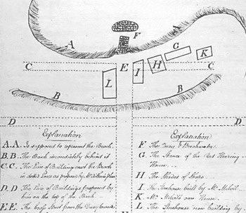
Ullapool was laid out to a simpler grid-plan by the surveyor David Aitken in 1789. David Aitken (active 1763–1804) had previously worked for the Annexed Estates Commission, as well as numerous private landowners in Ross and Cromarty and Inverness-shire. Aitken had trained under the north-east surveyor Alexander Sangster, who trained under John Forbes with the best-known surveyor of the North-East School, Peter May.Footnote 56 These associations put Aitken at the heart of the North-East School of surveyors. David Aitken's town plan for Ullapool has been lost but a sketch of the plan was made by Donald Macleod of Geanies, Sheriff of Ross-shire, who inspected the village in 1789 on behalf of the Society.Footnote 57 Macleod of Geanies' sketch shows that the plan was intended to be a regular grid, as at Tobermory, with a similar adaptation to the practicalities of the site (Figure 6). The main street, Shore Street, marked ‘C.C.’, runs parallel to the shore and features a terrace of housing and public buildings. As the bank along the foreshore was smaller than at Tobermory, the rising ground was incorporated into the rear gardens, or kail yards, of the building plots on Shore Street. Argyle Street, immediately above the bank, marked ‘D.D.’, runs parallel. These two parallel streets are intersected at the mid-point by a central cross-street named Quay Street, marked ‘E.E.’, which runs down to the town pier. Potential expansion of the grid was restricted to the west by the mouth of the Ullapool River but to the east the grid could be, and later was, expanded by a further block and cross-street, Ladysmith Street. As the sketch shows, Shore Street was laid out parallel to the shore, not parallel with Argyle Street as intended by Aitken, upsetting the uniformity of the grid-plan blocks. This was the lasting result of an error by one of the early building contractors at Ullapool, Robert Melville, who ignored the town plan when building the stores and herring-houses.Footnote 58
Donald Macleod of Geanies, Sketch of David Aitken's Plan of Ullapool, 1789, depicting the builders' divergence from the laid out street line (National Archives of Scotland).

The Society's links with the north-east through Sir James Grant of Grant and David Aitken are evident in the utilitarian planning and architecture of Ullapool and Tobermory. The high public profile of the Society subsequently ensured that Ullapool and Tobermory became the design template for the proliferation of planned villages founded in the Highlands through to the mid-nineteenth century. Of the thirty-five eighteenth- and early nineteenth-century Highland planned villages listed in Nic Allen's Gazetteer of Highland Planned Villages, only three, Grantown-on-Spey, 1769, Portree, 1763, and Lochboisdale, 1786, pre-date Ullapool and Tobermory.Footnote 59 All of those that post-date Ullapool and Tobermory were laid out on the standard British Fisheries Society grid-plan. In terms of function, twenty-one were established as fishing villages, whilst the remaining twelve were intended as centres for textile manufacturing.Footnote 60 The dual purpose of all these Highland planned villages was to turn a profit through the industrial exploitation of natural resources and to provide employment for estate subtenants, thereby preventing emigration. The specific focus of that industry, whether the herring fishery, slate quarrying or the manufacture of linen, was a matter of opportunity. To the twenty-first-century visitor to the Scottish Highlands the straight terraces of the typical planned village appear bleak and contrast unfavourably with the perceived romance of the Highlands. This has much to do with our romantic image of the Highlands inherited from the nineteenth century, which ignored the true, predominantly eighteenth-century, industrial character of the built environment in the Highlands.
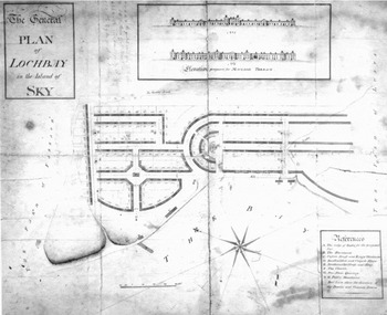
Thomas Telford's, largely unexecuted, 1790, plan for the Society's third settlement at Lochbay, Isle of Skye, marked a radical departure from the industrial grid-plan villages of the Society's first phase of activity. In contrast to the imposed grid-plan, Telford's plan for Lochbay is a sophisticated scheme based upon a system of interlocking crescents and squares which engage with the natural topography of the site (Figure 7). The two main focal points of the plan are the church square and the market square. In contrast to the early settlements, the two squares offer a focus for civic life inland, away from the sea and the fishery. In justification of his rejection of a standard grid-plan drawn up for the site by the north-east surveyor, James Chapman, Telford gave the following description of his plan for Lochbay:
The bottom of the rising ground with the middle street for a centre the market is made of a semi circle shape with street of the same surrounding it; this form is chosen in order to render the market place warmer, to help the ascent of the streets that communicate with the higher ground and to prevent a current of air from the streets above. The streets of the higher ground are laid out on the same principles of gaining easy ascent and preventing cross drafts of air for which purpose there is a row of houses which defend the ends of each of the streets. The large reversed crescent is made to suit the form of the ground, and to get the easiest possible ascent from the lower to the higher ground. On the top of the rising ground in the centre of a lozenge is the church.Footnote 61
Telford describes the scheme solely in practical terms of climate and geography with no reference to the contemporary, fashionable nature of the design and its novelty in the context of the industrial Highland planned village.Footnote 62 Of course, by the late eighteenth century, crescents and squares were no longer considered a radical invention, even on the small scale of the model estate village, but the British Fisheries Society villages were remote industrial settlements not model estate villages built to be admired. It is frustrating that Telford makes no reference to his design influences, only his intent, in either his correspondence or later biographical writings.
Thomas Telford, The General Plan of Lochbay in the Island of Sky, 1790 (National Archives of Scotland).

It can be inferred from Telford's diverse national work schedule during this period that he took his inspiration from markedly similar street forms he encountered on his travels elsewhere in Britain. For example, the crescent terraces and unified elevations with terminating pavilion wings in the proposal for Lochbay are reminiscent of Robert Adam's Lowther Village, 1766, which Telford visited when working in Cumbria in 1789.Footnote 63 As an avid follower of contemporary architecture, it is also likely that Telford had a second-hand familiarity with John Wood the Younger's widely celebrated Royal Crescent, Bath, completed in 1775, though he did not personally go to Bath until 1792 when he worked as a surveyor at Sir William Pulteney's Bathwick estate.Footnote 64 A familiarity with the plans and elevations of Georgian Bath would explain the strong similarities between Lochbay's proposed lozenge-shaped church square and Thomas Baldwin's, Laura Place, 1788–92, and its semicircular colonnaded market square with Baldwin's Cross, Bath, 1786.Footnote 65 However, Telford's deployment of the crescent as an enclosed street with its void filled by the semicircular central market-place was an innovation. The crescent in this period was still only employed as an open form and Telford's proposal for the ‘crescent-street’ had no British precedent.Footnote 66
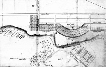
Following the high costs which mounted up at Ullapool, the directors of the Society were unwilling to invest money in Lochbay and Telford's plan remained largely undeveloped. Pulteneytown, therefore, was Telford's greatest contribution to the British Fisheries Society and to urban planning in Scotland. Pulteneytown was the Society's final venture and differed from the previous settlements as it is a New Town adjunct to the historic burgh of Wick not a pioneer settlement. Telford drew up a preliminary town plan in 1807, which featured a large shallow crescent facing away from the sea, similar to Peter Nicholson's 1806 plan for the ferry port of Ardrossan, Ayrshire, which Telford had visited (Figure 8). However, Telford substantially remodelled the plan for the final version of 1810.Footnote 67 The town plan of Pulteneytown is essentially a simple cross-plan running roughly east–west with a central open square, Argyll Square. Telford enhanced the scheme by designing the central square as a chamfered rectangle (Figure 4). Argyll Square is bisected lengthwise by the east–west axis of Grant Street and Dempster Street. The square is also flanked by enclosed angular, or canted, crescents, Breadalbane Terrace and Brown Street. All the residential streets were named after directors of the Society.
Thomas Telford, initial scheme for Pulteneytown, 1807 (National Archives of Scotland).

As with Lochbay, Telford explained his fashionable departure from the industrial grid-plan established by the Society purely in terms of geography and climate, ‘one great objective in forming the new plan was to exclude the north wind. At present the wind blows right across the flat evenly but it will hit the wall of the crescent and be forced down a side street.’Footnote 68 Telford's presentation of a fashionable and aesthetically considered plan to the practical and money-minded Directors of the British Fisheries Society in language which extols only its practical benefits is a fascinating example of the civil engineer's self-presentation and understanding of his clients.
As with Telford's proposed scheme for Lochbay there are strong formal similarities between the urban spaces of Pulteneytown and Thomas Baldwin's scheme for the Bathwick estate, Bath. The chamfered rectangle of Telford's Argyll Square is very close to the chamfered rectangle of Thomas Baldwin's Sydney Gardens, Bath, 1788–92.Footnote 69 In contrast to the Lochbay scheme, the probability of Bath having had a direct influence upon Telford is high as he had worked as a surveyor at Bathwick since 1792 and had overseen the completion of the scheme following Baldwin's dismissal as city surveyor.Footnote 70 And, Telford was impressed with what he had seen at Bath:
Modern Bath has been created by a Mr. Wood, an Architect, a man of very superior talents to whom, if I will, I hope do justice . . . I know of no instance in Ancient or Modern History of the conjunction of so many favourable circumstances . . . far excell'd the Bath of Diocletian or any of the Roman Works.Footnote 71
Telford's use of the fashionable urban forms of the crescent and square in the context of a planned industrial settlement in the Highlands – and selling it to practically minded clients – was a unique contribution to Scottish urban history. It also demonstrates that in his work for the British Fisheries Society though his designs may have been largely imitative their social application was innovative by providing enclosed civic spaces for industrial workers away from the centre of industry. Perhaps of greatest significance in terms of urban design was Telford's use of zoning to separate work from leisure: the clear division of Pulteneytown into a residential zone and an industrial zone each with a distinct architectural character. The genteel urbanity of the residential zone's crescents and squares juxtaposes with a strict geometric grid-plan in the separate industrial zone. Telford's architectural zoning has no eighteenth-century British precedent and should be more widely recognized. The industrial zone, known as Lower Pulteneytown, was laid out on ground close to the harbour and planned as a grid of nineteen plots grouped into four rectangular blocks, each block comprising two plots facing the harbour and four plots facing those of the next parallel block. The grid, and the correspondingly austere warehouses and depots, were built according to strict building regulations, which emphasized the functional and industrial nature of the zone. The industrial aesthetic was further emphasized by the original street names: Salt Row, Herring Row and Cask Row.Footnote 72 The repetitive geometry of Lower Pulteneytown was a forerunner of Telford's unrealized London Docks scheme for a monumental warehouse and embankment complex on the Thames, 1800, and pre-empted his later schemes for Gloucester Docks, 1826, and St Katherine's Docks, 1827–28, built ‘to rival the London Dock Company and the West India Docks’.Footnote 73 Pulteneytown is the most innovative example of eighteenth-century town planning in northern Scotland and the most complete example of Telford's work as a town planner. The historic significance of Pulteneytown was recognized by Historic Scotland when designated ‘Group Category A’ in 2002.
Harbours
The Society's harbour developments are matters of civil engineering not architectural history; however, the capital investment in harbour works was considerably greater than any amount invested in architecture or planning (Telford's creative town planning at Lochbay and Pulteneytown were only accepted by the Board of Directors as they cost no more to design or lay-out than a basic grid). For example, Robert Mylne's elegant neo-classical inn at Tobermory cost £792 whereas the harbour works cost £8,000, whilst the harbour works at Pulteneytown cost over £10,000 against no financial investment in buildings.
More than any architectural work, the completion of the harbour was the primary factor in the eventual success or failure of a settlement. The 700ft breastwork at Tobermory, quickly well built by Stevenson's of Oban, 1791, allowed the settlement to develop its fishery and its status as a trading port immediately (Figure 2).Footnote 74 In contrast, the harbour works at Ullapool were poorly constructed by the contractors Melville and Miller, and required expensive ongoing alterations immediately from completion. By the early 1800s Ullapool had declined into poverty as larger vessels could not use the harbour, which cut off the village from the offshore herring busses upon which an inshore fleet depended (Figure 3).Footnote 75 Despite a harbour scheme drawn up by Sir John Ronnie and Thomas Telford in the early 1790s, the harbour at Lochbay was not actually completed until 1802.Footnote 76 The large numbers that were initially willing to settle at Lochbay eventually emigrated to North America, citing the Society's unwillingness to commence works at Lochbay that led to their decision to emigrate.Footnote 77 In contrast, Telford's massive double-harbour complex at Pulteneytown, 1807–13, was the principal cause of the settlement's success, providing the infrastructure for an existing town and fishery to expand (Figure 4). Telford's first biographer, Samuel Smiles, wrote in the mid-nineteenth century:
Wick is now, we believe, the greatest fishing station in the world. The place has increased from a little poverty-stricken village to a large and thriving town . . . The bay is at times frequented by upwards of a thousand fishing-boats and the take of herring in some years amounts to more than a hundred thousand barrels.Footnote 78
Pulteneytown harbour was funded by the British Fisheries Society and the Commission for Highland Roads and Bridges. This joint enterprise was born out of Telford's highly influential Survey and Report on the Coasts and Central Highlands of Scotland, produced for the Treasury in 1802, in which he recommended the construction of harbours along the northern coastline of Scotland. Pulteneytown harbour was the British Fisheries Society's last project and the first harbour project by the Highland Roads and Bridges Commission, marking the transition to the next phase of the patriotic partnership in the Highlands, in which the emphasis shifted to government infrastructure schemes for canals, roads, bridges and harbours not planned villages, which were left to private landowners. From 1806 to 1821, the Highland Road and Bridges Commission was prolific in the construction of harbours and piers in northern Scotland.Footnote 79
Inns
In 1789 the fifth duke of Argyll wrote to his factor, James Maxwell, regarding the works at Tobermory. He stressed that the inn was ‘a building that ought to be very particularly studied and attended to . . . strangers will of course set the edge of their criticism upon the Inn in the first place’.Footnote 80 This was a deliberate design strategy previously employed by the dukes of Argyll at Inveraray. The Argyll Arms Hotel, Inveraray, Argyll, 1751–55, was built by William Douglas to an amended plan by John Adam.Footnote 81 At three-storeys high and nine-symmetrical-bays wide, it is the inn on a grand scale, described by Samuel Johnson as ‘not only commodious but magnificent’.Footnote 82 The inn at a newly established planned village was not just a functional building it was an architectural landmark, a statement of respectability, comfort and modernity, a deliberate and specific cultural indicator that the village, however remote, was an outpost of British society. The inn was intended as a place for the accommodation of travelling gentlemen, not the use of the village residents. Accordingly, the inn was the only building in which the Board of Directors expressed an interest in appearance beyond the uniform late eighteenth-century commercial classicism implied by the phrase much-used in the period: ‘neat and regular’. Accordingly Robert Mylne's work for the Society was almost entirely focused upon the design of inns. Robert Mylne was a contemporary of Robert Adam and a fellow Scottish émigré resident in London. Mylne is known for his innovative, early career design for Blackfriars Bridge, London, and a handful of country house commissions, such as Pitlour House, Fife, 1787, executed in a severely restrained neo-classical style reminiscent of Ledoux.Footnote 83 Much of Mylne's practice was devoted to infrastructure improvement schemes (canals, river navigations, roads, bridges) notably for the fifth duke of Argyll at Inveraray.
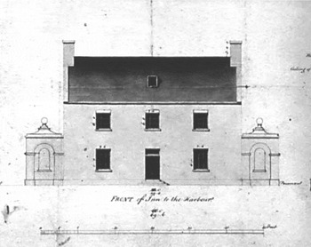
The Tobermory Inn, 1790–91, was Mylne's first and principal design for the Society; illustrated in Mylne's plan and elevation, the inn was an archetypal post-Palladian, Improvement-era small-scale house: a plain but well-proportioned two-storey, three-bay classical building flanked by single-storey pavilion wings (Figure 9). The pavilions were ornamented with blind arched-niches and ball-finials. Small-scale houses of this type were widely built throughout rural Britain, disseminated to regional craftsmen through architectural pattern books such as the Rudiments of Architecture, published in Edinburgh, 1773.Footnote 84 Laudale House, for example, was built c. 1770 for John Campbell of Ardslidgish, an improving tacksman-cum-tenant farmer of the improving fifth duke of Argyll. Laudale House is located just across the Sound of Mull from Tobermory on the Morvern peninsula and is one of the finest improved farmhouses in Scotland.Footnote 85
Robert Mylne, Front of Inn to the Harbour, Tobermory Inn, 1790–91 (Crown Copyright: RCAHMS).

An inn of identical design was planned for Ullapool. An initial plan drawn up by the contractor, Roderick Morrison, outlined a two-storey, three-bay building, ‘built of stone and lime, roofed with slate . . . and two wings one for the kitchens and servants the other as a byre and hay loft’.Footnote 86 Morrison's plans were sent to Mylne who produced ‘a new elevation and section of the Inn . . . only enlarging the Inn by addition of a sunk storey and drawing it's wings closer up to the body’.Footnote 87 Completed before the inn at Tobermory in 1790, the inn, which was heavily altered in the early twentieth century, was considered by Macleod of Geanies to be ‘an excellent one, but the Reporter fears will come to a much greater expense than the situation can afford any equal return from it’.Footnote 88 Telford surveyed the building in 1790 and concurred that ‘there seems to be an excellent inn and offices at Ullapool, too good perhaps for the probable resort to that place’.Footnote 89
At Lochbay only a temporary inn was built during the Society's period of ownership; the present building dates from the 1840s. The lack of a landmark British Fisheries Society inn at Lochbay is symptomatic of the general lack of development at the site. The Pulteneytown Inn, designed by Thomas Telford, stands on a prominent position overlooking the main harbour. The Round House, as it is known locally, was built by a local contractor, George Burn, in 1808.Footnote 90 The intended Pulteneytown Inn demonstrates that, as with the town plan, Telford liked to experiment with contemporary trends in architecture. The fashionable Picturesque-style of the early nineteenth century, disseminated by a new generation of architectural books, such as Robert Lugar's The Country Gentleman's Architect, 1807, is evident in features such as the hipped roof with over-sailing eaves, central roof-ridge chimneystacks and advanced, bowed window bays. Telford considered the completed building ‘an example of neatness’.Footnote 91 However, on completion Burn decided to make the landmark building his own house thus depriving Pulteneytown of a quality inn, although many small private whisky-shops and cook-houses sprang up around the harbour to meet demand.
Storehouses
A storehouse for the storage of equipment and materials relating to the fishery such as nets, salt and barrels was the third of the British Fisheries Society's three core public works. Essentially, the warehouses erected by the Society were plain functional buildings typical of eighteenth-century commercial classicism, and similar to the bonded warehouses of Scottish ports such as Leith, Edinburgh and the Port of Glasgow: well-ordered, two- to three-storey, stone-built and slate-roofed, buildings of regular elevation and rectangular-plan.Footnote 92 Again, the Rudiments of Architecture includes a design for this ordinary, functional building type (Design XX). Similar examples can also be found at many of the smaller Caithness fishing stations that sprang up in response to the success of Pulteneytown, such as Lybster, Staxigo and Clyth.
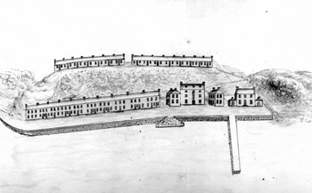
The size and quantity of storehouses built by the British Fisheries Society varied considerably from one settlement to the next. The first storehouse to go up was the three-storey King's Warehouse at Tobermory in 1789.Footnote 93 This building was designed and built by contractors Richards and Rodgers of Perth following alterations by Robert Mylne, who considered the original plans for a four-storey building ‘much too lofty for that climate’.Footnote 94 James Maxwell's 1791 sketch of the harbour shows a regular, gabled, three-storey building with a segmental-arched door to centre similar to that illustrated in the Rudiments of Architecture (Figure 10).Footnote 95 The sketch also shows the Tobermory Customs House and Lodgings, 1789–91, flanking the storehouse to form a U-shape complex facing the wharf. The symmetrical two-storey buildings with hipped roofs were a revised version by Maxwell of an elegant but costly design by Mylne.Footnote 96 The U-plan arrangement created a small public space for official and commercial transactions.
James Maxwell, sketch of the town of Tobermory, 1790 (Crown Copyright: RCAHMS).

In contrast to the regular scheme at Tobermory, the presence of two competing contractors at Ullapool resulted in a straggling street-line of mismatched stores and curing houses along the shore. The principal building along the shore remains the three-storey Great Storehouse with a first-storey forestair, built by William Cowie of Tain, 1789–90, marked L on Geanies' sketch map. A smaller storehouse for salt and casks had been previously completed in 1788 by Melville and Miller of Dunbar and roofed with pan-tiles shipped from Aberdeen. Geanies' sketch shows how Melville's poor alignment of the storehouse, marked I, with Aitken's street plan forced Cowie to build the Great Storehouse with an asymmetrical floor plan.Footnote 97 These buildings were supplemented with a further three-storey curing house and a large workshop with a pyramidal roof, both by Melville and Miller.
A small, single-storey storehouse designed by Thomas Telford was built at Lochbay in 1795 but it soon fell into disrepair. In contrast, the industrial archaeologist John Hume has commented that ‘the finest group of curing depots [in the Highlands and Islands] is at Pulteneytown’.Footnote 98 The store and curing houses of Pulteneytown's industrial zone were built by private investors. The uniformity of materials, construction and design was controlled by building regulations stipulated by Telford. Plots were initially sold at roup auction in 1808 with 11 taken; by 1817 all 20 plots were taken. Ever fashionable, the repeated blocks of storehouses built under these regulations relate Telford's Lower Pulteneytown to the contemporary architectural trend for ‘relentless repetition and obsessive geometry . . . of heroic geometry’ in large building complexes such as docks, prisons, barracks or asylums.Footnote 99
Domestic architecture
The design and construction of settlers' houses at Tobermory and Ullapool were controlled by building regulations designed to ensure uniformity of materials and design. The Society's strict building regulations ensured that the same design principles of regularity and order that governed the town plan and public buildings of each settlement would prevail in the settlers' houses, but at no cost to the Society.Footnote 100 Both villages still predominantly comprise uniform straight terraces of stone-built, slate-roofed, single- or two-storey, three-bay symmetrical cottages. Telford initiated a change of strategy at Lochbay, providing two elevations for the proposed Macleod Terrace, which was to have been built along the main shorefront. Both designs were for unified Palladian façades as pioneered by John Wood in Bath, Queen's Square, 1736, and Grand Circus, 1754 (Figure 7).Footnote 101 As initiated by John Wood in Bath the continuous façade was intended to allow the individual property owner or builder, who bore the cost of building, to design the internal plan as they saw fit whilst maintaining the overall architectural unity of the row. ‘Elevation No. 1’ was for a three-storey central block flanked by pedimented pavilions linked by plain single-storey terracing. ‘Elevation No. 2’ was designed on the same principle but arranged for two-storey terraces.Footnote 102 Again, the similarity of these elevations with Robert Adam's Lowther Village, Cumbria, 1766, is notable.Footnote 103 The flaw in Telford's scheme was that the intended occupants were neither the wealthy seasonal residents of Bath nor the recipients of a landowner's largesse as in the case of a model estate village such as Lowther. Later at Pulteneytown, Telford achieved a workable synthesis of the continuous façade and the Society's self-build regulation by removing the hierarchical Palladian element and prescribing the same plain and symmetrical, two-storey, three-bay elevation for all houses.Footnote 104
Conclusion
The early planned villages of the British Fisheries Society had an impact upon the urban development of the Scottish Highlands far out of proportion to their small number demonstrating the ability of a national body to impose remotely a consistent and, more or less, uniform ‘modern’ planning and design model upon distant and unconnected areas irrespective of regional building and settlement traditions. A high profile and influential national body's adoption of Robert Mylne's restrained neo-classical architectural style and the industrial planned village model developed in the north-east of Scotland set both the aesthetic and operative agendas of the subsequent Highland planned village boom in the late eighteenth to mid-nineteenth centuries. The planned villages of the British Fisheries Society and their successors had little success in establishing a sustainable dual economy in the Scottish Highlands. But in terms of the built environment the Highland planned village totally superseded the traditional bailtean as the typical Highland settlement pattern and continues to define the character of the Highland built environment today. In contrast, Thomas Telford's later innovative planning for the British Fisheries Society at Lochbay and Pulteneytown was of little wider influence. However, Pulteneytown was the Society's singular success becoming the greatest fishing port in Britain in the nineteenth century and Telford's town plan is today recognized as the most original and architecturally significant example of Georgian town planning in the north of Scotland.