

Introduction
This article examines the role of Chinese revenue farmers in defining the borders of the various colonial territories and the states of Southeast Asia during the nineteenth century. The role of these individuals has largely been neglected in the current writing on the formation of state boundaries. Nicholas Tarling, in his Southeast Asia: A Modern History, notes, ‘Between the late eighteenth and the early twentieth almost all southeast Asia was divided into colonies or protectorates held by the Western powers, and new boundaries were drawn with the object of avoiding conflict among them’ (Tarling, Reference Tarling2001:44). His view is typical of most who have studied the period.
While his comment acknowledges the role of the Western powers in surveying the boundaries, drafting treaties and map making, it really says nothing about how those divisions were actually policed and made real on the ground. This aspect of ‘border making’ was left to the independent Chinese monopolists who worked on behalf of the colonial regimes. This paper examines their role during the middle years of the nineteenth century and attempts to give an account of their significance in the organization of colonial governance and in giving substance to the formalistic pronouncements of remote diplomats and statesmen.
Borders and Populations
Southeast Asia presents a unique case historically because despite the fact that the major states have long-standing historical traditions, until the nineteenth century, most lacked clearly defined borders. It can be considered to have been a region without borders or clearly defined frontiers between major political units.
This situation seems to have been the result of a number of environmental factors. On the one hand, the region is almost uniformly tropical and thus was originally covered by dense tropical rainforest. This forest, to a great extent, remained uncut and uncleared until the second half of the twentieth century. Likewise, the coasts and great river valleys of the region were covered by large tracts of swampy lowlands, which required considerable inputs of manpower before being available for cultivation. Coastlines in many areas were marked by vast expanses of mangrove swamp, and even inland, by swamp forest.
These conditions and the warm, moist temperatures of the equatorial and sub-equatorial areas militated against the settlement and growth of large concentrations of human beings. Even where it may have been possible to bring large numbers of people together at any one time, continued residence in one spot would ultimately create considerable sanitation problems which would lead to the proliferation of parasites and the outbreak of epidemics. As a result, population densities throughout the region tended to be historically low.
Historically, throughout most of Southeast Asia, land by itself has not been a scarce resource. The most valuable productive resource before the nineteenth century was manpower. Manpower was necessary to man armies, to build monuments and to produce exportable commodities, and especially to produce more food to produce more manpower. The natural accumulation of manpower, however, was a long, slow and irregular process. Anthony Reid estimates that the population of the region in 1600 was just over 22 million. Vietnam, the largest, had only about 4.7 million, concentrated in the north and the centre. Java (4 M), Burma (3.1 M), Sumatra, (2.4 M) and Siam (2.2) followed. None of these represented a single political unit. By 1800, the entire region had increased by a little under 50% (Reid, Reference Reid1988:15), but compared with Europe, China, India and even the Middle East, this was still an area marked by ‘demographic immaturity’. Reid comments:
Its overall density of population of about 5.5 persons per square kilometer contrasted with densities for South Asia of about 32 and for China (excluding Tibet) of about 37 (after McEvedy and Jones 1978). Further away Europe had roughly double the Southeast Asian population density.
Reid argues that the main reasons for the extraordinarily low populations were warfare and religion (Reid, Reference Reid1988:16).
Even though there were areas of extremely fertile soils, such as the volcanic islands of Java and Bali, and many fertile alluvial areas, land clearance and intensive agriculture required inputs of labour, and this key factor of production was always in short supply. As a result, where powerful political units did develop, they often did so by the means of ‘capturing’ a population and subjugating it to labour in the service of the king.
One area where populations tended to grow was near the seacoasts where smaller river valleys and coastal lowlands, such as those along the coasts of the Malay Peninsula and the Gulf of Siam existed. These were more manageable than the larger river deltas such as those of the Irrawaddy/Salween, the Chao Phraya and the Mekong. With such areas under rice cultivation, and the nearby sea and rivers as sources of protein, pockets of population could flourish. It was necessary, however, to be able to defend themselves from enemies that might arrive by the sea.
It is well known that Southeast Asian waters were periodically dominated by ‘pirates’ from the earliest recorded times. The phenomenon of piracy in this area needs to be understood in relation to the demographic situation. One of the main targets of sea-borne raiders was the people themselves. James Warren's discussion of the activities of the Illanun raiders during the late eighteenth and early nineteenth centuries in the Philippines and around the coasts of Borneo and the Malay Peninsula shows the political and economic utility of such activity. Captives could be sold, and they could also be brought back to the home base and employed in the business of producing export commodities to trade with Chinese and other foreign traders who visited the Sulu Sultanate (Warren, Reference Warren1981).
It is probable that the first major Indianized state of the region, Funan, located near the mouths of the Mekong River managed to establish itself by means of such raids on nearby populations. Likewise, the chronicles of Ayutthaya constantly refer to the practice of ‘sweeping up’ populations by armies moving between the Siamese heartland and the Cambodian population centres around Angkor in the fifteenth and sixteenth centuries. Later, during the nineteenth century, we see the same sort of activity along the eastern shore of the Gulf of Siam between the mouth of the Chao Phraya and the Bassac. Warfare in eastern and central Java in the sixteenth century reduced populations in that area, as did warfare in central Sumatra during the eighteenth and nineteenth centuries (Reid, Reference Reid1988:15). The goal of every political leader or leadership group was to draw population, whether by transport, intimidation or by enticement.
Reid points out that lives were not necessarily lost in warfare, rather he points to the ‘instability created by constant low-level warfare’ (Reid, Reference Reid1988:17).
The larger states mobilized a substantial proportion of their male population into vast, ill-organized armies, without providing adequate supplies either for the soldiers or for their families left behind. Thousands of captives were marched back home by the victorious armies of Burma and Siam, or shipped home by Aceh and Makassar, with incalculable losses on the voyage. Perhaps an even more important factor demographically was the need to be constantly ready for flight in troubled times. This probably meant avoiding births at least until the older children were able to run by themselves (Reid, Reference Reid1988:17).
The resulting demographic situation was that not only did overall population densities remain quite low, but that populations were generally concentrated in pockets of intensive wet-rice agriculture or else in maritime trading cities that, according to Reid, were ‘surprisingly large in relation to the overall population’ (Reid, Reference Reid1988:18). Such groupings provided safety in numbers, since large population concentrations were better able to defend themselves. As such, these groupings also served the ends of the rulers as well, since it placed their key resource within easy reach.
I argue here that one of the results of this demographic situation has been a particular style of political and geographical imagination that was characteristic of ruling groups in the region. Benedict Anderson's pioneering article on the idea of power in Java speaks to the demographic and historical reality of most of Southeast Asia (Anderson, Reference Anderson1990). Anderson argued that power was seen as something to be concentrated and accumulated around the person of the ruler. This is the way in which Southeast Asian rulers handled their subject populations. They brought them close to the capital and worked to prevent the growth of the outlying accumulations, which might challenge their own centrality.
Mandalas and Maps
This principle applied even to provincial towns, which were regularly cut down to size, often as staging areas for wars, or as outlying buffers that could be sacrificed to defend the capital. In fact, provincial towns, far from the centre could just as easily either fall into enemy hands, or, even worse, change sides and join forces with an enemy. The Burmese invasions of Siam in the 1760 were certainly facilitated by the defection of these outlying centres such as Chiang Mai. This led to a policy of centralization, which is explained in Pornpun Futrakul's thesis on Siamese provincial towns before the twentieth century (Futrakul, Reference Futrakul1989).
As a result, borders or frontiers between countries, such as those between Siam and Burma, or Siam and Cambodia, were generally nothing more than extensive tracts of wasteland or forest. They were largely uninhabited except for the few hunter-gatherers who dwelt in the deep interior well away from marauding armies and slave catchers. In the Malay world, the key geographic limit of a ‘country’ a negri was normally a river valley. To be technical, the border was the watershed, but in practice the border was an extensive area of ulu, or simply the ‘up-river’ area, which was empty of people.
The centripetal state structure that emerged from these conditions is expressed in the ‘mandala’ theory of interstate relations, a concept elaborated both by Anderson and by O. W. Wolters (Wolters, Reference Wolters1999). Anderson points out that the mandala presupposes that one's immediate neighbour is one's enemy, because power is not distributed equally in the kingdom, but is concentrated at the centre and is weakest at the edges, on the border. This is just where, as Anderson says, a ruler's . . .
. . . sphere of Power merges into the perimeter of his neighbour's. Thus, if his control is not to be diminished and weakened by the pull of his neighbour's Power, he must first exert his own Power against the neighbour. We may recall how the idea that the total quantity of Power in the universe is constant implies that any increase of Power in one place means an equivalent diminution elsewhere. Since Power is also fluid and unstable, always ready for dispersal and diffusion, interstate aggression necessarily becomes a basic assumption about interstate relations (Anderson, Reference Anderson1990:44).
A border, as we understand it today, was never a site of negotiation or regulation between congenial neighbours, rather it was either a site of conflict or else, a wasteland.
Along with this political principle, Wolters also argues that a ruler's mandala was not necessarily territorial. Rather, the mandala could easily be somewhat interrupted. Political power did not need to be contiguous over a piece of territory. What mattered were networks of relationships and bonds of loyalty. This was particularly true of island Southeast Asia where the port-polities of the Malay world could maintain far-flung alliances with other quite distant political units. (Kathirithamby-Wells and Villiers, Reference Kathirithamby-Wells and Villiers1990) This model applied to states as diverse as eighth-century Srivijaya, fifteenth-century Melaka, seventeenth-century Banten and nineteenth-century Sulu. Even seventeenth- and eighteenth-century Ayutthaya seems to fit their model.
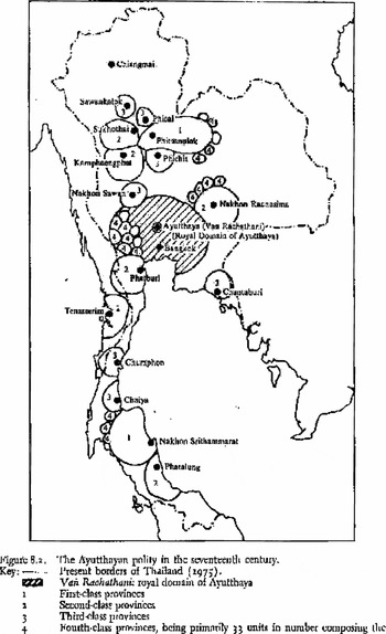
If we look at Stanley Tambiah's mapping of pre-modern Siam's ‘galactic polity’ as it may have existed in the seventeenth century, we get an idea of the manner in which Southeast Asian kingdoms were organized (Tambiah, Reference Tambiah1976:134–7). (Figure 1) The state was really composed of the capital area and its immediate dependencies, smaller principalities and towns that were under the direct control of either the royal family or powerful groups within the court. Beyond them, both in distance and levels of central control were the first-, second- and third-class provinces. The first- and second-class provinces were principalities that were nearly autonomous tributary kingdoms in their own right, some of which had their own dependencies, such as Phitsanulok, Nakorn Rachasima (Khorat) or Nakorn Srithammarat (Ligor). Beyond these were even more autonomous political units such as Cambodia, the Malay states of Patani, Kedah, Kelantan, etc. and Chiang Mai. These latter ones were only occasionally under the control of Ayutthaya and merely sent the gold and silver flowers as tokens of their subsidiary status. In times of war, they might be called upon to provide troops, but they could just as easily be won over by alien powers in the next circle such as Vietnam, Burma and Aceh or Johor.
Tambiah's galactic polity of Ayutthaya c. 1700.

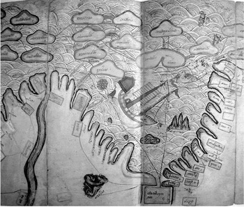
Although based on a reading of Siamese chronicles discussed in terms of Siamese ideas of statecraft, Tambiah's maps are his own creation and represent a construct that is informed by the late-20th-century concepts of geographical space. Thongchai Winichakul, on the other hand, has tried to explain what he sees as the contemporary Siamese concepts of space. His study, Siam Mapped looks at a number of early ‘maps’ of the kingdom (Winichakul, Reference Winichakul1994). The earliest ones appear to be more concerned with a cosmic vision (i.e., the Traiphum, or the Buddhist cosmology) rather than any kind of realistic representation of a portion of the earth's surface. One of the early maps does, however, seem to offer some degree of representation, that is what he calls the Coastal map (Winichakul, Reference Winichakul1994:Fig. 4) which dates from the time of Taksin (1767–1782), but it appears to come from an earlier period since it is an Ayutthaya-centred map and does not show Bangkok or Thonburi. This is Thongchai's description:
There is another fascinating map in the Thonburi version of the Traiphum pictorial manuscript: a coastal map from Korea to Arabia which was incorporated into the description of the human world in the Traiphum scheme . . . In this map, all the coasts are lined up along the bottom part of the map and all the seas are in the upper part. It begins with Korea and Japan situated in the sea, followed by the Chinese coast opposite Taiwan rightward to Canton. The Vietnamese coast appears like a peninsula jutting into the sea with the mouth of the Mekhong River at its peak and the coast along the Gulf of Siam in a trough (panel 2). At the bottom of panel (3), Ayudhya appears as the biggest city in the gulf (Winichakul, Reference Winichakul1994:29).
It is of interest too, that the map, even though a Siamese map, does not really show Siam as a kingdom or as any kind of a unitary entity, rather it simply shows Ayutthaya as a bigger and slightly more elaborate square than all of the other polities shown there. Also, while the various polities around the Gulf of Siam appear to be in the more-or-less the correct location, in terms of their north–south orientation along the shore, there is no scale of distance (although the distances between towns are given in notations) nor is there any attempt to represent landforms as anything other than blobs. The Gulf is a large ‘trough’ with Ayutthaya at its base. The Malay Peninsula, to the west of Ayutthaya is simply a wide wedge of land similar to the Indochinese Peninsula to the east. The various principalities along the coast are represented by rectangles with the name written inside. Schematic indentations along the coastline show river mouths (Figure 2).
Coastal map from Vietnam to the Malay Peninsula. Source: Klemp et al., Reference Klemp, Wightman and Wightman1989; Map 42.

In other words, Southeast Asian kingdoms, or states, or polities, or whatever we want to call them, were not seen to exist, either substantively or figuratively as contiguous blocks of territory surrounded by sharply defined borders. Rather they were towns surrounded by undefined territory. Borders, or frontiers, were broad zones of emptiness, and to some extent were systematically kept that way. What counted were the towns and areas where population was concentrated. On the maps, all we really see are the towns.
In a very real sense, this sort of geographical thinking was quite appropriate. The blank spaces in between the kingdoms were, to the contemporary peoples, simply spaces of undifferentiated forest and wasteland, inhabited only by forest savages or wild beasts. There would be no real reason to change their thinking about frontiers until such time as there were people to fill them up. There would, of course, be even more pressing reasons to demarcate clear borders when Europeans began to seize territories in the region and draw the borders themselves. This is perhaps the most well-recognized reason for the institution of borders in the region.
This line of causation is the one adopted by Thongchai. He sees the ‘mapping’ of Siam as an enterprise that grew out of pressures on the Siamese state by both the British and the French. British activities on the Malay Peninsula and Burma led to the demarcation of a border between Siamese and British territories there. French interest in Cambodia called for a line in the east. As late as the 1880s, Siam still had no border and had not been mapped in such as way as to show the actual shape of the kingdom with a clear line drawn around it. Lines had only been drawn to mark out the borders of Siam with Kedah and Kelantan in the south, and another line between Battambang and Siem Reap cutting through the Great Lake. The north-eastern borders with Cambodia and the borders with Laos and Burma in the east, north and west did not yet exist.
I would like, however, to look beyond these well-documented colonial actions and to dwell on another, perhaps subsidiary factor that supported the border-making process in Southeast Asia. There is no doubt that European expansionism was one of the key factors driving the creation of maps and the demarcation of frontiers in the region. Another aspect of the frontier issue in Southeast Asia that needs attention is the role of the Chinese. I would argue that Chinese were important in a number of ways that have been largely overlooked.
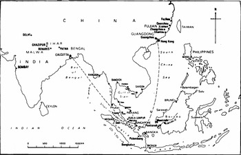
The first role played by Chinese was as pioneers. Their role has generally been ignored in the mainstream discourse of growth and economic development in the region. In my own work over the past few years, I have begun to develop an argument that would shift the focus, at least partially, to the activities of the Chinese. If we go back to the eighteenth century, to a time and place when European activities within Southeast Asia were rather limited, it is clear that a new era of Chinese settlement in the region was already underway. A glance at the map of the region as of about 1780 shows that 20 or so settlements, a number of them exclusively Chinese, had been established in the region since the beginning of the century. This included places like Hatien, Trat, Chantabun, Songkla, Trengganu, Sambas, Pontianak, Riau, Phuket and Bangka. These settlements can be seen as a part of what we have come to call the ‘water frontier’ (Cooke and Li, Reference Cooke and Li2004) (Figure 3).
Indian Ocean and South China Sea showing major sites of Chinese settlement in the 18th century.

Southeast Siam, particularly the towns of Bang Plasoi (now Chonburi), Rayong, Chantaburi and Trat—all ranged along the coast of the Gulf of Siam, between the eastern coast of the Bight of Bangkok and the Cambodian border—was a key area of the water frontier. Together with Hatien, founded around the 1680s or 1690s, they seem to have been among the first settlements of Chinese labourers in Southeast Asia. By the mid-eighteenth century, we hear of tin-mining settlements appearing at a number of places in the Malay Peninsula: Chumphon, Nakron Srithammarat and Songkhla in southern Siam; Kelantan and Trengganu in the Malay states on the east coast. On the west coast, there were Chinese tin miners in Perak and Phuket (Junk Ceylon). There were pepper and gambier planters on Bentan Island in the Riau Archipelago, gold miners in Pontianak, Sambas, Mempawa and other sites on the Kapuas river in western Borneo; pepper planters in Brunei; and tin miners in Bangka. All of these were established during the eighteenth century, and all were characteristically commercial establishments. In general, they had little or nothing to do with European trade or colonialism and were purely a part of the expansion of the mainland Chinese economy at the height of the Qing boom during the reign of the Qianlong emperor.
There were earlier Chinese settlements in Southeast Asia, but these were almost exclusively in important European colonial capitals (e.g., Melaka, Batavia, Manila, etc.) or else in Southeast Asian state capitals such as Ayutthaya, Hue, Kedah, Palembang, Tanjong Pinang and other significant port-polities in the region. Except for limited Chinese populations of craftsmen, mariners and some urban labourers, these were primarily merchant settlements. The new development in the eighteenth century was marked by the establishment of colonies of Chinese labourers. These settlements were ‘economic’ in nature in that they were rooted in commercial production for export. They produced commodities that were saleable in China. The key commodities in question at the outset, in the eighteenth century, were pepper, sugar, gambier, tin and gold.
How did these settlements spur the demarcation of borders? First of all, it is worth noting that the places chosen for settlement were in areas that were not heavily settled. Mineral deposits, in particular, are almost always found in sparsely populated hinterland areas, and in the mountains or foothills. Agricultural settlements, while often close to earlier Southeast Asian settlements, were not always near the largest ones. In many respects, the new Chinese settlers were moving into those blank spaces on the map that had previously been uninhabited. Moreover, these new settlers were now making them economically significant regions, providing taxable commodities produced by taxable subjects.
Chinese Settlers on the Siamese Border
One area that has drawn my interest is the Siam–Cambodian border region along the Gulf of Siam. In the towns of Chantaburi (formerly Chantabun) and Trat (formerly Tung Yai), we can see the process of border formation in action. Before the eighteenth century, Chantabun, the largest and oldest town in the area, was one of those border principalities that typically got overrun and reduced by marauding armies from both the east and the west. The earliest mentions of the town are in the Chronicles of Ayutthaya where it is claimed as one of the dependent kingdoms of Ayutthaya in 1351, during the reign of King Ramathibodi, the first king of Ayutthaya (Cushman, Reference Cushman1996:10–11).Footnote 1
However, during his reign, the city was sacked by a Cambodian army and depopulated. The population was restored some years later by King Ramasuen (1388–1395) who, after defeating Chiang Mai, deported its population to Chantabun and other cities on the Malay Peninsula (Cushman, Reference Cushman1996:12–3). The chronicle mentions a second depopulation of Chantabun at the end of the sixteenth century during the reign of King Thammaracha (1569–1590). In fact, the Cambodians ‘swept up’ the population of the entire coastline.
At that time the King of Lawaek [Cambodia] repeatedly organized troops to scout about, both by land and by boat, and the inhabitants of Chanthaburi, the inhabitants of Rayong, the inhabitants of Chachoengsao and farmers were speedily lost to the Lawaek enemy in great numbers (Cushman, Reference Cushman1996:77).
These are the only two mentions in the Chronicle of the systematic relocations of population that happened on the Thai–Cambodian border during the Ayutthaya period. No doubt there were more. There are other reports that tell of a major Thai invasion of Cambodia in about 1720. While Chantaburi is not mentioned in the accounts, one might be safe in assuming that the city's male population was targeted for conscription into the military, if nothing else. The invasion was described as a failure, and so it is probable that not many of them came home. British country trader Alexander Hamilton visited Siam and other countries in the region around the beginning of the eighteenth century reported:
In 1717 the King of Siam made war against Cambodia & sent an army of 50,000 by land and 20,000 by sea and committed care of his Armies to his Barkalong [Prah Klang] a Chinese, altogether unacquainted with War. The China man accepted of the Charge with much Reluctancy, but the King would not be denied. The War proved unsuccessful . . . (Hamilton, Reference Hamilton1739:97).
At the time, Hamilton remarked on the desolation of the Siamese–Cambodian coastline: ‘. . . for 50 Leagues and more along the Sea-shore, there are no Sea-ports, the Country being almost a Desert’ (Hamilton, Reference Hamilton1739:104).
Fifty years later, however, conditions had undergone a major transformation. The towns of Chonburi (Bang Plasoi) Rayong, Chantaburi and Trat (Tung Yai) were all thriving settlements, populated by a highly variegated mix of peoples that included Siamese, Chinese, Vietnamese, Malays, Cambodians and other indigenous groups. Where had these people come from and what were they doing there?
It is clear that one important group which had settled there was a community of Chinese pepper planters. Indications are that these were mostly Teochew agriculturalists that probably had some links to the Teochew pirates who were said to roam the coasts of south-eastern Siam. Other reports also suggest that there was a similar settlement of pepper planters further east at Tung Yai.
There was also a community of Cochinchinese Christians who had fled from persecutions in Dang Throng. They were under the leadership of the French missionaries of the Missions Étrangéres de Paris (MEP) who had established missions in various parts of Vietnam, Siam and Burma. They do not appear, however, to have been the first Vietnamese to arrive in Chantaburi. There were also many non-Christian Vietnamese in the town.
The presence of Malays, Bugis, Orang Laut, Chams and other Southeast Asian seafarers would have been a common thing in the region for many centuries before. French and Dutch reports from the early eighteenth century indicate that a large proportion of the population of Ayutthaya were Malays. It seems clear that Malay seafarers were active throughout the Gulf of Siam before the nineteenth century. The Natuna and Anambas islands were important rendezvous sites for the Orang Laut of the Johor–Singapore straits and the Bugis (Ali Haji ibn Ahmad, Reference Ali Haji ibn Ahmad1982).Footnote 2
This portion of the water frontier was anchored by the port of Hatien, also known as Cancao and Puntaimas. Founded by the Chinese seafarer, and perhaps pirate, Mac Cuu in about 1690, the settlement had grown into a flourishing entrepot by the middle of the eighteenth century. Although the town was listed as a tributary by the courts of Vietnam, Cambodia and Siam, it was largely autonomous during the eighteenth century. It too had a mixed population of Siamese, Cambodians, Chinese, Vietnamese, Malays, etc. (Mantienne, Reference Mantienne2003:45).
It was sacked by the Siamese in the 1720s, but the port recovered and continued to be important in the newly emerging economy of the Gulf of Siam and the mouth of the Bassac. Records from Macau indicate that Hatien shipped considerable quantities of rice, timber, tin and pepper to China. Since none of these goods were produced in Hatien, one assumes they must have been drawn there through a shipping network that linked it to the Gulf, the Straits of Melaka and even Java. Mantienne notes that it had a prosperous trade and welcomed Chinese junks from Batavia, China, Melaka, Siam and Cochinchina. During the 1760s and 1770s, while Siam, Cambodia and Vietnam were disrupted by civil war and invasion, Hatien was a place of refuge. It was here that the French priests of the MEP moved their base as did the Franciscans who had been active in Vietnam. The missionaries and their flocks were welcomed by Mac Thein Tu who had succeeded his father as the ruler of Hatien (Mantienne, Reference Mantienne2003:41–48).
Although the populations in towns such as Chantabun were mixed, one must assume that it was the Chinese who were largely responsible for the increase. The large numbers of labourers were producing new wealth and thus a spurt in economic activity that created a general wave of prosperity. In fact, Paul Van Dyke, working on the Canton trading system has actually been able to trace the money. He shows a pattern of European company merchants in Canton and Macau (British, Danish, German, etc.) advancing money or participating in joint ventures with the Hong and other Canton merchants. This cash not only helped work the tea trade, but also financed the Chinese merchants' trade to the Nanyang, much of which was in search of commodities that were accessories to the tea trade (e.g., rattan, tin, lead, rice, etc.) (Van Dyke, Reference Van Dyke2005).
As the Chinese filled up the blank spaces on the map, the regions drew the interest of nearby Southeast Asian rulers and colonial powers. Chantabun, by way of example, with a thriving population of Chinese planters and others became an important site in the 1760s. Particularly, in 1767, after the Burmese had sacked Ayutthaya, the region of southeast Siam along the eastern shore of the Gulf was one of the few areas that had been spared the ravages of war. It was thus to Chantabun that Phrya Taksin retreated. He was a Sino–Thai trader and tax farmer who had helped to defend the capital. He fled to Chantabun in June of 1767 with a force of about 500 men. He left from there six months later with an army of 5,000 men and 100 ships (some of which he built and others he confiscated from Chinese traders/pirates in Trat). With this force, he returned to the Chao Phraya and defeated the Burmese at Bangkok and established his new capital across the river at Thonburi.
The Chinese of Chantabun and Trat were vital resources in restoring the kingdom. Not only did he recruit much of his new army from the region but also, for much of Taksin's reign, the Chinese merchants and mariners whom he had recruited there played key roles in building up his treasury and reconstructing the Siamese state. These were mostly Teochews and Taksin's patronage gave them key positions in the Thai state even after he was deposed (Aeusrivongse, Reference Aeusrivongse1986:135–138). Even though the most prominent Chinese during the Ayutthaya period were Hokkiens, the power of numbers and influence shifted to the Teochews from then on until the present time.
The earlier connection between the southeast coast and Hatien was, from the very beginning, a major issue for Taksin. As it turned out, a major competitor for the kingship of Siam was Mac Tien Tu, the ruler of Hatien. The latter was actually named as the ruler of Chantaburi in one Thai source (Chaowatratanawong, Reference Chaowatratanawong1997:111). This was probably an error, but it indicates the level of power in the region that Hatien had come to exercise by the end of the Ayutthaya period.
There was, however, a greater threat from Hatien. Mac Tien Tu had given refuge to two princes from the Ayutthaya court who, according to Chinese ideas of legitimacy, should have been the legal successors to the Siamese throne. Chen Ching Ho has written at length on the issue and has shown sources that tell us Mac Tien Tu wrote to the Chinese court challenging Taksin's right to succeed. Indeed, it was not until the very end of his reign that Taksin's control of Siam was recognized by the Qing court.
In the immediate wake of Taksin's conquest of the Burmese garrison at Bangkok, Mac launched an attack on Siam's southeast coast and took both Chantabun and Trat. The following year, in 1769, Taksin retaliated, retaking Chantabun and Trat and then going on and sacking Hatien. These struggles between Taksin and Mac Tien Tu have been interpreted in a number of ways. Yumio Sakurai has seen it as a struggle between Teochews and Cantonese (Sakurai, Reference Sakurai, Cooke and Tana2004). Chen Ching Ho has seen it as a struggle between two Chinese warlords (Chen, Reference Chen1977) and Puangthong Rungsawadisab has called it a struggle for control of the Gulf of Siam and the Trans-Mekong trade (Rungswasdisab, Reference Rungswasdisab, Cooke and Li2004). Whatever the case, certainly an underlying factor in the continuing struggle in this area would be the real lack of a recognized border between the Siamese, Vietnamese and Cambodian realms, together with the possibility that Chinese adventurers like Mac Cuu, his son and Taksin could all hope to carve out a kingdom of their own in the region.
It would be more than another century before the border dispute in this region would be decided. Taksin and Mac Tien Tu fought again in the 1770s when Taksin captured Tien Tu and brought him back to Thonburi to die in prison. In the 1780s, the Tayson rebels moved into the region and further reduced the power of Hatien. The town was henceforth a part of the battleground where Gia Long, in his extended struggle, defeated the Tayson brothers in the 1780s and 1790s. In the 1830s, a new war erupted between Rama III and the Vietnamese Minh Mang emperor, which would lead to further devastation in the region. On the other hand, Bangkok strengthened its command of the south-eastern shore of the Gulf throughout the period from 1820 to the 1860s. Crawfurd reports that taxation of Chantaburi's pepper crop had increased significantly in the Bangkok period over what it had been before 1767. The real border, however, would not be finally drawn until the early twentieth century. Chantaburi and Trat were seized by the French in 1893 in their final imperial push in the region to expand the frontiers of Cambodia and Laos at Siamese expense. The territories were not returned to Siam until the treaty of 1907, which forced Siam to give up all of the eastern Cambodian provinces (Siem Reap, Sisiphon, Battambang and the western end of the Tonle Sap) that it had held since the 1840s (Tuck, Reference Tuck1995:Ch. 9).
Borders and Kangchus
Clearly, the borders were finally hammered out as the result of political power plays by both, the French and the Siamese, but it was the presence of Chinese settlers who made this border a contested area in the first place. If we turn our attention to the Malay world, we see similar border-drawing activities inspired by the Chinese presence. During the nineteenth century, the state of Johor came to be populated by Chinese pepper and gambier planters moving there from Singapore. Here it is somewhat difficult to distangle Chinese systems of boundary drawing from those of the Malays.
The first Chinese settlements in the region had been made at Riau in the mid-eighteenth century. While the evidence is not entirely clear, it appears that territories on Bentan Island were parcelled out to Chinese headmen known as kangchus (Lord of the port). About the time Raffles signed the treaty with Temenggong Abdul Rahman and took possession of Singapore, Chinese pepper planters were already establishing themselves there. By the 1840s, the cultivation was exhausting the available land in Singapore and began to move across the strait to the Peninsula. I have argued in my earlier work that this was simply the same system of cultivation moving from one place to another (Trocki, Reference Trocki1979).
In Johor each kangchu was given a small river valley and allowed to bring in labourers to develop the land within his watershed. He was also charged with managing the revenue farms, that is, the tax concessions. He was given the right to sell or provide smokeable opium (chandu), spirits, gambling, prostitution, betel nut and even theatrical performances.
It seems natural that the Malay rulers would have divided their territories up according to river valleys and watersheds. The river was the established focus of the Malay negri, and under the Malay political system, these riverine states were divided by subsidiary tributaries, each one under a pengulu, literally, the headman of the ulu, or up-river area. The unique thing about the kangchu system was that all of the nomenclature was Chinese, rather than Malay. The Chinese headman was a kangchu, and his place of residence was the chukang, and the place was usually named with the surname of the headman. Thus the kangchu's settlement on the Tebrau river in Johor was Tan Chukang, named after Tan Kye Soon, who founded it. The names of the old pepper and gambier settlements on Singapore island are still in use: Lim Chukang, Yio Chukang, Chua Chukang, etc.
This use of Chinese names suggests that the system actually owed more to the Chinese settlers than to the Malay rulers. In Singapore, it seems that the system was entirely of Chinese creation and management, since the Malays were not in possession of the island when the Chinese planters occupied those portions of it. It is difficult to say how much the system may have owned to Malay/Bugis management when it began in Riau. By the time the Chinese reached Johor, (in the 1840s) the system seems to have become fixed and under the Malay ruler was more formally systematized with the issuance of written documents to the kangchus and overall management of the system by Malay bureaucrats (Trocki, Reference Trocki1979).
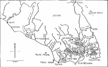
There are two issues that concern us here. One is that the system of land division and border marking seems to have owed something, if not everything to Chinese initiative. Beyond that, it owed a great deal to Chinese management. The second thing is that in addition to being a division of territory for settlement and exploitation, it was also a division of territory for the taxation regime: the revenue farms. In fact, the question of control of the revenue seems to have been one, if not the key matter of concern in the issuance of the surat sungai, or ‘river document’ which the Sultan issued to the kangchu. The fact that the kangchu controlled the revenue concession on his river was mentioned in every single surat sungai in the collection of these documents in the Johor archives. If we look at the map of the kangchu settlements as of the mid 1860s, we get some idea of the areas under settlement and the regions controlled by Chinese tax farmers (Trocki, Reference Trocki1979) (Figure 4).
Johor Kangchus as of 1860.

In another example from Johor, a few decades later we find a Malay explication of how land was divided. In this case, after a number of disputes among Chinese tin miners in the territory of Bukit Mor, the Sultan had sent his brother, Ungku Abdul Rahman along with the Dato Bentara Dalam, Ibrahim bin Munshi Abdullah. In his memoir, Ibrahim explained the principle of territorial division according to watersheds.
What I have described as rivers are not like most rivers, big and deep and flowing into the sea, but are merely creeks or rivulets. Every stream invariably flows to low ground or a swamp (kuala), and always runs between two hills, and rises on a hill. Whenever a stream flows down from a hill, passes between hills and reaches a swamp, it ceases to flow and empties itself there. This point is called its mouth, and outlets of this sort always have hills to the left and right of them. It has been decided that the limits of a river-mouth are where the hills on either side come to an end. It has also been decided where the boundaries of the rivers are, and that each river shall be owned by one towkay. Each river shall extend from the farthest point upstream to the mouth, excluding the hill in which it rises. The width shall be 300 feet from the river-bank to the left and right, and no more. If there is another river or stream nearby, then the boundary must be half-way between the two. The boundaries of a swamp must not go beyond the foot of the hills on either side of it nor must its length exceed 1,800 feet square (Ibrahim, Reference Ibrahim1975:23).
For nineteenth century Malays, hilltops and watersheds were the keys of land division. On the whole, these were not lines on a map, but tended to be rather remote and thinly populated zones, where travel was slow and difficult, and the rule of the raja was rarely exercised with much effect. However, when it was clear that those using the land would be occupying the entire territory, these principles could be refined to actual lines on a map as they were later in Borneo.
Singapore's Opium Farmers
If we look at the revenue farming systems that operated in Singapore, we see the much larger superstructure of which the Johor chukangs were merely a component. The opium and spirit farms for Singapore island, during the nineteenth century were the largest and most lucrative tax regimes in British Malaya. They were managed by the wealthiest and the most powerful Chinese businessmen in the colony and, in Singapore, regularly constituted between 40% and 60% of the entire revenue. The entire colonial enterprise in Southeast Asia was financed by revenue farms. Every colony, every state farmed out the bulk of its revenues to Chinese tax farmers.
We cannot understand the nature of European colonialism in Southeast Asia without acknowledging the role of opium. In virtually every colony, the revenue collected from the sale of chandu, or smokeable opium, was one of the mainstays of the colonial revenue. If Singapore was, perhaps, an extreme case, this was only because of its commitment to free trade and to its lack of taxable exports. Other colonies drew revenues from taxing the export of tin, pepper, rubber, rice, etc. or from head taxes on Chinese or other Asian immigrants. Even in them, however, opium revenues rarely constituted less than 30% of the gross state income (Trocki, Reference Trocki1999).
For the purpose of this study, the important issue is that the tax farms were territorially based. That is, each tax concession was issued after competitive bidding, to a specific individual (usually to his company or syndicate) for a limited period of time (usually 3 years) over a specific piece of territory. This left to the Chinese businessman who collected the revenue, the task of maintaining the boundary of that territory and of preventing the smuggling of opium, or spirits, or whatever commodity was being controlled across that boundary. Europeans may have drawn and surveyed the borders, but it was the Chinese businessmen who policed them and gave them reality on the ground.
If we look at the Dutch and French settlements in the region, the story is very much the same. It may be that the Chinese who ended up controlling the opium farms of French Indochina controlled some of the same territories before the French arrived. Whether they did or not is immaterial, the fact is that as soon as the French began to define their boundaries, they began to employ Chinese farmers to patrol them and give them substantial meaning.
If we return to the territories of the old Water Frontier during the 1860s, we find that after a disastrous attempt to allow the farms of Cochinchina to be managed by Europeans, the French had given the revenue farming contract to a syndicate of Cantonese led by a merchant known as Wangtai (his trade name), but his syndicate only held it for the year of 1864. The following year it was taken over by a group of Singapore Chinese led by one Banhap (also a trade name). He and his partners, the three Tan brothers, (Tan Keng Ho, Tan Keng Hoon and Tan Keng Seng) held the Cochinchinese farms for nearly two decades, from 1865 to 1882 (Dumarest, Reference Dumarest1938:44–45). It was these Chinese businessmen and their employees who policed the new boundaries of Cochinchina and divided it from Cambodia on the west and from ‘Annam’ on the north and east. French sources report that the rivalry between the transplanted Singapore Hokkiens and the Cantonese shifted off and on into the 1870s. Sometimes the Cantonese came into a partnership with Banhap, other times, they were rivals. In 1871, another Cantonese, Watseng, was able to take control of the Cambodian farms. Apparently, both syndicates launched smuggling operations against each other and, to a certain extent, patrolled the newly drawn border between French Cochinchina and the protectorate of Cambodia. A French official in Cambodia wrote warning of the threat of armed clashes between the forces of the two farmers (Moura, Reference Moura1871).
The key point of interest here is that the major smugglers were usually other opium farmers, very often the rival competitors for the same farm. The best means of retaliating after being defeated in the bidding for a particular farm was to obtain the concession for a neighbouring farm. Even if the neighbouring territory was not really a very lucrative opportunity as such, it offered the possibility for the losing syndicate to both stay in business and to get revenge on their rivals.
This was a common strategy and it provided the occasion for opium farmers to both define and violate the newly created colonial borders. In Singapore, it was always necessary for opium farmers to go to pains to obtain the similar farms for the Dutch islands of Riau, and those of the Malay state of Johor. In Penang, the farmer had to be sure to obtain the farms for Kedah. In Hong Kong, the strategic offshore territory was Macau. Beyond that, Hong Kong itself was a prime smuggling location for the China market. Almost every major colonial city had an adjacent ‘suburb’ of sorts that lay in another jurisdiction and thus lent itself to smuggling. It was in these areas that the Chinese businessmen who managed the revenue farms showed their mettle by both defining and violating the border.
This phenomenon of cut-throat competition between revenue farmers was a paradoxical thing. While it was often seen as a ‘problem’ by colonial governments, it was actually an integral part of the system. In order to obtain the highest possible price for the farm, the government relied on a process of competitive bidding. But, that always left a loser. Moreover, it left a loser who, if he was a serious competitor, already possessed wealth, power, influence and the necessary infrastructure to run the farms. That infrastructure was expensive to maintain, and so smuggling was not just an opportunity for revenge. It was a necessity for survival.
James Rush has told the story of the revenue farms of Java, and he too has called attention to the propensity of rival farming syndicates to smuggle against one another there (Rush, Reference Rush1990). In my earlier work, I have shown that these smuggling contests could be the cause of considerable social unrest. Normally, the various revenue farmers had alliances with one or another secret society, and once they were armed the propensity for serious violence was very high. In Singapore, individuals such as Tan Seng Poh and Cheang Hong Lim had shown they could provoke significant disruptions in their struggles through the 1860s (Trocki, Reference Trocki1990). Similar violence periodically erupted in French Cochinchina, in Penang, southern Siam and in Java.
If these conflicts were seen as a problem for the colonial governments, there was one thing that was worse. That was collaboration. In Singapore, Penang, Cochinchina and even Hong Kong, the syndicates ultimately came to terms with one another. They decided to create joint farms, amalgamate the adjoining territories (despite political boundaries) and split the profits. This led to the situation of the same syndicates policing both sides of the various borders. While this created social peace, it also meant that the farmers could present the government with an offer that it could not easily refuse: an offer that was usually far below the real value of the farms.
The loss of revenues led to further internationalization of the revenue farms. The first steps had already been taken by the farmers in amalgamating adjacent territories under the same farming syndicate. The farming syndicates were thus not just states within states, but states that transcended states. In 1879, the governor of Hong Kong John Pope Hennessey (a man who had formerly served in the Straits), invited the Singapore revenue farmers to bid for the Hong Kong farms. He was dissatisfied with the low bids being offered by the local Cantonese joint farm and decided to force their hand. The result was something far more sweeping than he had expected.
One of the Singapore farmers formed a combine with the above-mentioned Straits-born farmers of French Indochina and took over the Hong Kong farms. In 1879, Banhap joined his Saigon partner, Tan Keng SengFootnote 3, the Singapore opium farmer, Cheang Hong Lim and a few other Hong Kong Cantonese. Apparently, the aim here was to create a truly global opium monopoly. By this time, small groups of Straits-born Chinese had come to control both the Singapore and Saigon opium farms. It appears that they also dominated the traffic in coolies from Fujian and the Chaochou region of Guangdong to Singapore and much of western Southeast Asia. The two rival opium groups in Hong Kong also controlled the traffic in Cantonese coolies to the United States, Australia and the other parts of the Pacific Rim. Together with the coolie traffic, they also controlled the flow of prepared opium to those settlements. Had Banhap and his partners succeeded in keeping their company and their concessions together, they would have been in a position to dominate the entire world market in opium and Chinese coolies.
Although it seems ironic, the Straits-born Chinese of Singapore had moved beyond the mere business of maintaining colonial borders and were attempting to create networks and alliances that not only spanned those borders, but also violated them. It was an attempt to create an empire within an empire. Like many over-ambitious enterprises, the vast Banhap syndicate collapsed almost as soon as it was born. It was attacked from virtually every angle. The ousted Hong Kong company adopted the usual strategy of securing the Macau farm and began to smuggle into the markets that Banhap had hoped to dominate (Consul de France, 1879). Moreover, their business to the California and Australian coolies was in prepared opium (chandu) rather than raw opium and opium farming. What commanded the market was brand recognition. In this case, the rival Cantonese syndicate still owned the brand names that were favoured in those markets. They also attacked the combine from the inside by having some members join and then file lawsuits when financial difficulties arose.
Europeans also moved to destroy the business of this combine, although it is probable that they had other aims in mind. Opium shipments and the coolie trade to California and Australia were both discouraged by restrictions on Chinese immigration, newly enacted in those countries—another aspect of border maintenance. In Saigon, the French finally decided to take the farms away from Banhap and create a state-run monopoly, and in Singapore, Cheang Hong Lim's company lost the farms to an outsider from Penang. So, by 1881, the entire venture had collapsed.
It was inevitable, perhaps, that the colonial governments would tire of these games, and from the 1880s onwards, as they gained resources and as attitudes against revenue farming hardened, governments created their own monopolies. In 1882, the French were the first. They took the farms from Banhap and company and created the first régie (Descours-Gatin, Reference Descours-Gatin1992). In the 1890s, after a series of smuggling squabbles and excessive bidding by potential farmers, the Dutch in Java followed the French and created a monopoly (Rush, Reference Rush1990). Finally, in 1910, after a spectacular financial debacle in which the Singapore farms collapsed and the farmer went bankrupt, the British too, decided to take the opium business into their own hands (Trocki, Reference Trocki1990).
The creation of government monopolies marked the end of an era in Southeast Asia. Throughout the nineteenth century, opium farms and opium farmers had been the key instruments of border maintenance for the colonial states. With the system of monopolies, the colonial governments not only undertook the business of manufacturing and retailing prepared opium to their populations, they also undertook the police functions of protecting their monopolies, which included the whole business of border maintenance. It is no accident that Eric Tagliacozzo focuses his study of smuggling and smuggling prevention on the period between 1870 and 1910, for these are the years in which we see the internationalization of opium farms and the first moves by colonial powers to take direct control of their borders.
Conclusion
This has been a wandering excursion on the ins and outs of Southeast Asian mapping and border making, along with a discussion of Chinese settlement and opium farming. The aim here is to bring together all these disparate threads.
The overall point is that Chinese migration and business development have been an important part of the ‘bordering’ of Southeast Asia. It might be possible to argue that in the beginning, even though there were states, there were no borders. This was largely because there was an insufficient population. While indigenous Southeast Asian populations were probably beginning to increase by the beginning of the eighteenth century, it is clear that major increases came from Chinese migration. It is also important to note that a significant portion of this Chinese migration was exactly to the border areas that had previously been empty. This process of migration to Southeast Asia continued throughout the nineteenth and into the twentieth century, not slowing until the 1930s.
From the 1830s, Southeast Asia entered a period when the newly established colonial governments came to rely largely on Chinese opium farmers to aid them in the management of their new states. The middle years of the nineteenth century up to the 1880s, is generally recognized as a period of laissez-faire colonial rule in the region. Even in directly ruled territories such as the Straits settlements, Hong Kong and Cochinchina, much power and many functions of government were delegated to private actors. To the revenue farmers fell much of the task of border maintenance and tax collection. In fact, it was during these years that most of the borders were actually defined, if not precisely surveyed and mapped.
The years after 1880 saw the progressive rationalization of the colonial states throughout the region. Colonial bureaucracies were professionalized and the functions of government, particularly tax collection, policing and border control were gradually taken fully into the hands of the state. Professional surveyors, on both sides of the notional borders precisely defined the lines. Police forces and coast guards were deployed to man the borders and to regulate the movement of goods and people across the newly established frontiers. By 1910–1915, much of this process was complete, and the need for Chinese business people to carry out the functions of the colonial state was no longer as necessary as it had once seemed.
Finally, it is necessary to draw attention to the fact that these new borders have, for the most part, defined the current nation-states of Southeast Asia. Within the ‘histories’ of these nations, the role of the Chinese and of the revenue farmers is generally ignored. National history should be made by national actors, and the Chinese do not generally qualify for that role.