

In December 1959 two brothers, Arthur and William Houghton, made a remarkable discovery whilst ploughing a field near Isleham in Cambridgeshire. They reported the discovery to A R Edwardson, the curator of the Moyses Hall Museum in Bury St Edmunds,Footnote 1 and he and some students from Oxford (Dennis Britton, Mike Tite, Jeffery May and Richard Linington) then organized a small investigation in March 1960. From this work some 6,500 bronze pieces were recorded (weighing c 90kg), the largest founder’s hoard in the country, consisting of cut-up bronze items, casting debris and the small-scale waste (‘the sweepings’Footnote 2) from a metalworker’s floor. The metalwork had been found with parts of a large ceramic container and appeared to have been buried in a pit in the chalk.
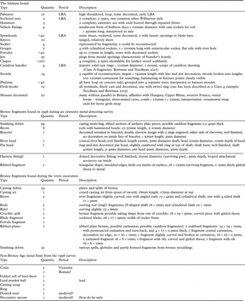
The immediate discovery and first overview of the contents of the hoard were published by Dennis Britton in 1960, and an initial catalogue produced by A R Edwardson in 1970 (table 1). Since that time the contents of the hoard have attracted a number of studies that were intended to analyse and catalogue the finds in a more detailed manner,Footnote 3 and some of these have come to publication.Footnote 4 From these studies the understanding and significance of the hoard has increased so that it can be characterized as Wilburton phase c 1150 to 1000 cal bc,Footnote 5 with c 2,500 items from weapons and related martial equipment, but also featuring 2,600 plate ingots, as well as cauldron fragments, horse-harness decorations and a number of tools. Analysis of the metallurgy has shown that much of the metal is of ‘S’ type (characterized by impurities such as arsenic and nickel), continental in origin, which is similar to other Wilburton hoards,Footnote 6 with central Europe being the probable source. The Isleham plate fragments, however, are of ‘H’ type metal, typified by arsenic as the only impurity but with some added lead that would therefore suggest a source more characteristic of the British Isles, and these conclusions have been further refined by lead isotope analysis.Footnote 7 Some items included within the hoard are rare, if not unique, within Britain, such as vehicle fittings,Footnote 8 flesh-hooksFootnote 9 and three draw-plates that are amongst the earliest surviving evidence of this method for manufacturing wire, a technique more commonly associated with the Scandinavian Viking period.Footnote 10
The Isleham hoard as classified in the Moyses Hall Museum Catalogue (see Edwardson Reference Edwardson1970) and further finds made during metal-detector survey and excavation during 1998 and 2000

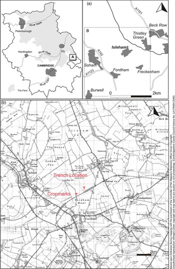
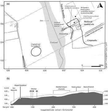
There was, however, considerably less attention paid to the exact location and context of the hoard (Britton refers to a ditch and an old soil with burnt and worked flint), and its findspot became diffused over time (figs 1 and 5). Britton’s original report gave a six-figure national grid reference of 52/635728, the Cambridgeshire Sites and Monuments Record had a location for it of tl 633727, whereas a 6in. map at the Moyses Hall Museum had two locations, one of which (tl 633725) was marked as ‘verified’ by Edwardson. He had also written this grid reference as a correction into the margin of a letter received from Christopher Hawkes where he quotes Britton’s grid reference. A letter in the museum archives, from Elizabeth Owles to the Ordnance Survey in 1976, explains the confusion: ‘the site was in the middle of a 30-acre field and as he only had a 60-ft tape and 1″ to the mile map, he couldn’t pinpoint the site accurately. I see his point!’ Edwardson also provides a topographic description in his catalogue: ‘The site lay at map reference 52/633726 approximately on the 20-foot contour where the land imperceptibly slopes to the level Fen land and clearly marks the eastern shore line of the Fen’. This description accords very well with the actual location as re-discovered in 2000.
Site location showing the position of the trench: the 1954 map shows the landscape as it was when the hoard was found in 1959

David Hall of the Fenland Survey made an attempt to locate it accurately on the ground with the help of the Houghton brothers, the original finders of the hoard, but unfortunately this failed because the landscape itself had changed significantly since 1960: what had then been a 15-ha field had become a 50-ha one by the 1980s. The location for the hoard (ISL26) given in the Fenland Survey was thus taken from the SMR, although Neolithic blades, cores and flakes (ISL5) are recorded as coming from the approximate site of the hoard at tl 63337262.Footnote 11 Hall also notes that a discoidal knife was found at this location in 1964 and records the presence of a dark area with calcined flint to the north. The soil mapping in the Fenland Survey volume, however, places the area of the hoard on dry land, at least 1km south of the nearest fen edge. In addition to the hoard other finds had been made on the Houghton brothers’ land, such as the discoidal knife mentioned above, and at least two large pits (in 1963) that showed as black patches in the field, one of which contained four to five barrowloads of calcined flint, although no scorching was apparent on the chalk.Footnote 12 The pits were stepped and flat-bottomed and, apart from the flint, there is also mention of pot sherds, the coarse ones resembling those of the vessel in which the hoard had been found. The implication of these finds could suggest that burnt mounds existed adjacent to the channel of the River Snail, and close to the hoard.
Analysis of other evidence for the area surrounding the hoard include aerial photographs, which reveal a possible cropmark enclosure and field boundary (also shown on the 1st edition Ordnance Survey map), as well as a sinuous course of the dried-up River Snail, which was followed by the parish boundary between Isleham and Fordham. In the surrounding landscape around the reputed hoard site a number of ring-ditches have also been seen on air photographs, as well as a much larger circular feature 70m in diameter with a 50m long ‘tail’ attached to it located c 500m west of the hoard in Fordham parish.Footnote 13 The flint assemblage from this site, described by Hall as an earthwork, was assigned a Bronze Age date, and was also noted to contain some blades and fire-cracked flint (FOR12). Further finds of worked flint were recovered close by at tl 629732, but such finds were not exceptional within the wider landscape of the Fordham–Isleham area. This lies within a peninsula of the mainland that jutted out into the fens, which David Hall remarks upon as containing prolific spreads of lithics from Mesolithic to Iron Age times.Footnote 14
In 1989 I was appointed to undertake an archaeological survey of the Cambridgeshire County Farms Estate,Footnote 15 on whose land at Chalk Farm the Isleham hoard had been found, and on my first visit to the area worked and fire-cracked flints and some soil marks were all that were visible within an apparently bleak expanse of ploughed farmland just north of the redundant Isleham railway line. The micro-topography of the area, however, clearly showed a slope down to the west, to what must have been a tongue of fen that had formed running inland along the lowest course of the River Snail, and that had been canalized by a modern drainage ditch. The location and context of the hoard became a personal research project, stimulated by my supervision of the Fengate Power Station excavation with its timber ‘avenue’ and associated Bronze Age and Iron Age metalwork, and the on-going debate about the siting and function of hoards within ‘wet’ areas. Over the following decade several methods were employed to try to pinpoint the hoard site accurately and to investigate the area around it in some greater detail. This paper presents that story and also gives an account of related studies that help to provide a context for this important hoard.
The management of the County Farms Estate was in a state of change during the early 1990s owing to increasing demands on it to provide benefits to the general public well beyond its original remit of enabling people to get started in farming. At Isleham, for example, one particular area was allocated for tree planting in 1993; this area coincided with one of the locations for the Isleham hoard as listed on the Sites and Monuments Record. In response to this, Geophysical Surveys of Bradford undertook magnetometer prospecting of the area to see if the hoard site could be located and thus appropriate management implemented before trees were planted over it.Footnote 16 A general scan around the SMR location at tl 633725 covered an area of 250 by 250m; within this area, three blocks, totalling 0.5ha, were selected for detailed survey. The results of this work showed two intermittent linear responses, which tied in with slight undulations surviving in the field surface consistent with a medieval field system. No signal was detected that showed a potential site for the hoard, although some weak anomalies might have derived from archaeological features such as pits.
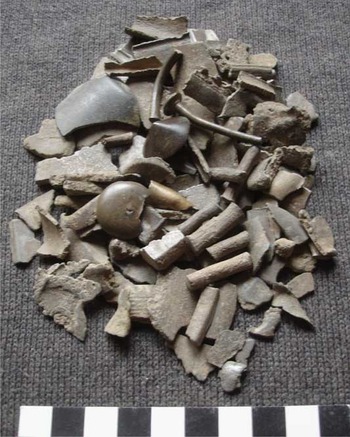
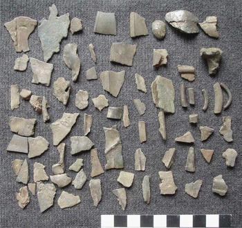
The next initiative was a gridded metal-detector survey conducted by Chris Montague of the Archaeological Field Unit, Cambridgeshire County Council, with the aid of the St Neots and District Artefacts Club and the East Cambridgeshire Metaldetecting Club. This was undertaken after harvest in September 1998 and an area of 220m east–west by 90m north–south centred on tl 63237254 was gridded out in 20m squares. All signals were investigated and artefacts retrieved, identified and plotted on to a plan of the area. A concentration of small scraps of bronze was defined, totalling 115 pieces over an area of 40sqm, with a dense area of finds of 20sqm within the more extensive concentration (fig 2; table 1). The surrounding area was largely devoid of metal finds, apart from some eighteenth- to nineteenth-century ironwork, a Charles I groat and a bronze ‘finger’ ring with overlapping tapering terminals of possible Bronze Age date. Burnt flint and waste flakes, as well as a barbed and tanged arrowhead, were also found.
Bronze objects recovered during the 1998 survey

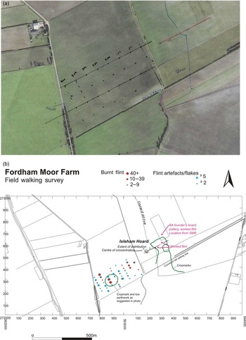
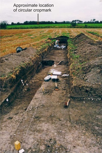
This very successful episode of structured prospecting was followed in March 2000 by a fieldwalking survey of the field further west, across the lower lying land and modern drain that separated Chalk Farm, Isleham, from Moor Farm, Fordham. Within this field lay the large circular earthwork first identified by David Hall, and also an area of peat that lay between the earthwork and the concentration of bronze scrap (figs 3 and 5). An area of 400m east–west by 200m north–south was gridded out into 50m squares and a total of 137 flint tools and waste flakes were collected (of earlier Neolithic and Bronze Age date), with an additional 447 pieces of burnt flint (fig 3b). The distribution appeared to have some focus over the circular earthwork, which could also be seen distinctly on the ground as a soilmark, but in particular there was a concentration of burnt flint along the edge of the peat deposit in the low-lying eastern part of the field. The cropmark was trenched in 2001 and was recorded as lying at 5.43m AOD; although ploughing had severely eroded the monument (which was clearly visible as a circular bank and ditch on air photographs) there was sufficient evidence surviving in the southern part to reveal the base of a bank and ditch and associated pits. The ditch was almost 5m wide and, although extremely shallow, was filled by a sandy-silt deposit with worked flints, flint-tempered pottery and pieces of antler.Footnote 17
(a) Air photograph showing a circular cropmark and a darker area to the east along the course of a prehistoric stream (now a straight drain); (b) fieldwalking results and the location of the trench in relation to the cropmarks

Within one and two kilometres to the north, excavation as part of a water pipeline has provided further Bronze Age context for the hoard. In 1993–4 the Cambridge Archaeological Unit discovered a complex of inter-cutting pits located within hollows created by the undulating chalk.Footnote 18 The pits contained a large faunal assemblage with worked and burnt flint and Bronze Age pottery. On one of the raised chalk areas a round-house, 25m in diameter, was found, and further away a natural pond infilled with large quantities of burnt flint was identified, although no evidence for burning at this location was found.Footnote 19 Further investigation where the pipeline crossed the Crooked Drain (the dry channel of the River Snail) revealed large quantities of burnt flint on the west side associated with four pits, and worked flint on the east where a post-built structure lay, as well as human bone within peat deposits beside the river channel. A sequence of samples and a monolith were taken from the deposits filling the River Snail palaeochannel and pollen analysis, combined with radiocarbon dating, showed an environmental sequence that began with pine dominance during the Mesolithic, giving way to oak and elm, and then mixed deciduous woodland, including lime and ash, in the early Neolithic, with evidence for interference leading to woodland glades of ash, willow and ivy. This was followed by woodland clearance and alder decline and some cereals in the middle–late Neolithic, before extensive woodland clearance during the Bronze Age led to a fully developed pastoral and arable landscape during the mid–later Bronze Age.Footnote 20
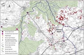
The wider Bronze Age landscape setting for the Isleham hoard, including other hoard sites, contemporary watercourses and wet fenland, and major routeways, is superimposed over the 1st edition OS mapping in fig 4.
Bronze Age sites in Isleham and Fordham and adjacent areas, and the extent of Bronze Age fen

Methods And Summary Of Excavation Results
The successful metal-detecting survey in 1998 had found a possible location for the hoard (a concentration of small pieces of scrap bronze) which was worthy of further investigation. In August 2000 access was agreed with the farmer, Phil Boon, to evaluate the land after harvest employing a very simple strategy consisting of trial trenching and metal-detecting.Footnote 21 The aims of the research were: to locate the 1960 excavation and hoard findspot; to investigate any associated evidence that might help to provide a contemporary context for the hoard (in particular the peat deposit and former wetland area in the west of the field); and to provide further detail to help in the beneficial management and future research of the site.
The first stage was excavation of a single 235m trench by mechanical excavator from the east side of the field directly through the cropmark ditches and river channel seen on air photographs, through the concentration of bronze finds as plotted from metal-detecting and further west into a lower-lying area of peaty soil (fig 5a). This previously wet area lay on either side of the drain that separated the hoard field from the field with the circular earthwork at Moor Farm. The field sloped from east to west with a drop of 1.94m in the field surface over the length of the trench (fig 5b). In addition to the trial trench, two metal-detectorists (Chris Montague and Roger Allison) scanned the area on either side using a hoard hunter, tuned for all metal signals. Oral history reported that a plough share had been placed in the pit in 1960 after it was excavated, and it was therefore expected that this would produce a good clear signal if the story were true.
(a) Trench layout, associated features and their relationship to previously recorded locations for the hoard site; (b) topographic trench profile

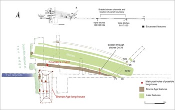
At the east end of the trench a depth of c 0.35m of topsoil was found overlying the chalk, but at the west end the wetland sequence of deposits was over 1.3m in depth before degraded chalk was found. The trench revealed a number of archaeological features, ditches and gullies in the first 90m from the east, with a series of dry water channels for the next 40m (fig 6). Solid chalk alternated with an orange-brown subsoil at 0.4m depth, and some ditches crossed the trench over the length 130–200m from the east end. The chalk levelled out at this point and dark filled features were evident, together with a distinct zone of fire-cracked flint along the edge of the silts, which dipped down into the wet area. At the western end of the trench, 215–235m from the eastern end, deep deposits of silt and desiccated peat were encountered.
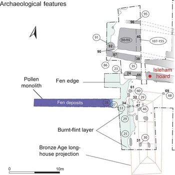
After the initial trench was complete a small area was opened to the south of the trench, around the 200m mark, as small finds of bronze scrap were being found in this area by the metal-detectorists (fig 7; table 1), perhaps the spillage from sieving in a potato-riddler that had been undertaken during the 1960 excavation. This was also the area where the trench had revealed a post-hole and fire-cracked flint along the ‘fen edge’ and seemed a possible area of occupation (fig 6). Indeed, as the area was opened up it revealed further archaeological features and layers located on a slightly raised ‘terrace’ of chalk at 4.5m AOD.
Plan of the trench and a detail of the western end, with hoard and occupation features, and a plan of the Barleycroft Farm long-house superimposed

Metal-detected finds from the 2000 survey

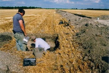
In addition to the bronze scrap, a number of strong iron signals were detected by the hoard hunters, and the second of these that Peter Northover and I excavated was just 4m north of the trench between the 216 and 218m mark from the east end. Beneath 0.35m of topsoil our test-pit uncovered a 0.9m-wide slot filled by tan-coloured friable silt, a slot that had been cut through a compact black ‘greasy’ silt containing flint nodules, which filled a feature cut into chalk natural. The tan-coloured soil proved modern and within this matrix a galvanized bucket was found, inside which were the remains of a newspaper and a counter-sink from a seed drill (fig 8): the paper was dated March 1960, so there was absolutely no doubt that we had found the location of the hoard at tl 63197253. Approximately thirty pieces of bronze were found within the spoil from our test pit (table 1). A second area was then opened up to connect the hoard spot with the main area of excavation just to the south (fig 9).
Relocating the hoard: finding the bucket and counter-sink weight that had been left in location in 1960

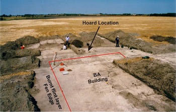
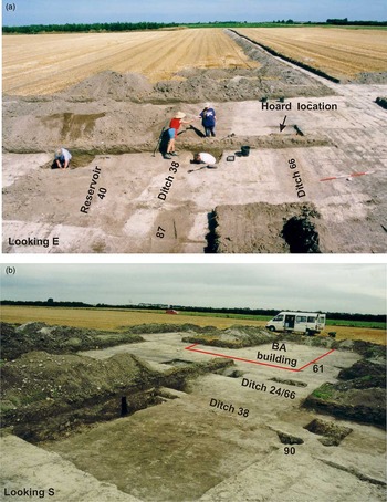
The main area of the excavation (looking north) with a possible building in the foreground

At the east end, a second trench was excavated, parallel to Trench 1 and 35m to the south, to investigate a ditched enclosure originally identified from air photographs. This was also clearly visible on the ground in the field itself as a linear depression and colour difference in the stubble. The wide ditch enclosed a platform containing gullies, and both soft brick and green-glazed pottery (c 1200–1350 in date) were found. This enclosure was therefore interpreted as a moated site, possibly one that has been referred to as ‘Little Isleham’.
The subsequent cleaning, planning, sampling and excavation of the features and deposits exposed in the trench area around the hoard have provided a considerable amount of information as to the immediate context of the hoard, and the detail of this is presented in the ‘Location’ section below. In summary the hoard appears to have been deposited in a ditch, one that had already been at least partly infilled when the pit for the pot containing the scrap bronze was dug into the ditch fill. The location of the hoard was 5m east of where the ditch terminated on the fen edge. The ditch was not isolated, but lay within a landscape of concentrated features, with a second ditch lying 3m to the north, and beyond this a 5m-wide flat-based artificial channel (at first interpreted as a ‘tank’ or reservoir), and then a further ditch (figs 7, 11 and 14). These features all converged with, and cut, the ditch containing the hoard, some 20 to 30m to the east, and therefore post-dated it. Along the fen edge a solid zone of fire-cracked flint existed, and to the east of the wet deposits and south of the hoard lay several post-holes and pits that could have formed part of a structure, resembling the plan of a long-house.Footnote 22
One of the aims of the investigation was to establish the context of the hoard, and therefore the concentration of features around it afforded an excellent opportunity to gather much important data on this context. Within the short period available, therefore, as many features as possible were sample excavated (fig 14; tables 2 and 3). All artefacts were collected during this hand-excavation of the features, which were, in general, only sampled so as to obtain dating evidence and to provide a profile and section through their infill, and thus parts of every feature have been left in situ. Particular attention was paid to the ditch in which the hoard had been hidden (it had been placed in a pit cut through the infill sequence). Fire-cracked flint was not retained, but it was weighed and counted from all excavated features to act as a measure of its relative frequency.
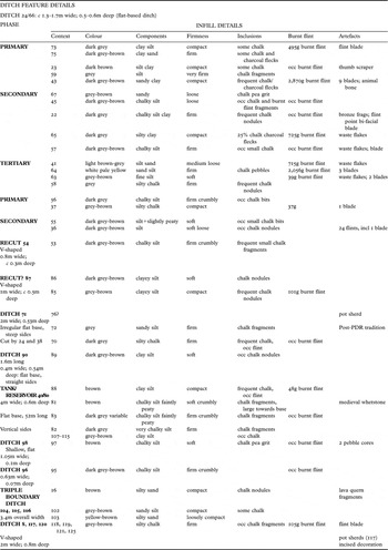
Details of ditch features

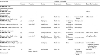
Post-hole and pit details

Of particular research interest was the local environment contemporary to its deposition. Within the machine-cut trench a deeper hand-dug section along the south side of the trench was taken from the fen edge 6m into the wet deposits to investigate this key interface zone, and to trace the sequence of wet deposits as they had lapped up over the chalk (fig 10). Sampling was undertaken of the fen deposits at the western end of the trench by means of a 0.7m soil monolith (primarily for pollen and peat characterization). Bulk soil samples were taken from the ditch containing the hoard, from the large rectangular ‘channel’ feature, and from other selected features for molluscan analysis. The hope was to find overlap between the results from the wetland sequence and those from the ditch fill.Footnote 23
Looking south west: in the foreground, a section cut through the fen edge sequence (see fig 13); in the middle ground, taking soil samples for the peat monolith from a sondage; in the background, the drain and ring work in the field beyond

Following the excavation the trench and hoard location were backfilled, with the galvanized bucket placed back in the hoard pit. Coins contemporary with the excavation and labelled plastic bags were left in various features as time capsules and to help with relocating the site for future investigation. The site continues to be used for arable cultivation and its condition of preservation would benefit from periodic monitoring through a programme of trial pitting, and a specific agreed management plan. It is not protected as a scheduled monument or through any incentive scheme and the plough-scar marks seen during excavation demonstrate active erosion.
The location of the hoard
The bronze hoard had been stored within a ceramic container, and this had been placed within a pit excavated into the fill of a ditch. The original description of the find was reported by Britton but the extent of the 1960 investigation was very limited (a 5 by 6m area) and therefore the fact that the hoard was dug into a ditch was not obvious: ‘within the area excavated were patches of an old soil and a ditch, with traces of human activity … a flint industry, quantities of fire-crackled flints, and a few scraps of pottery. But none of this could be connected with the hoard’.Footnote 24 Throughout his report Britton refers to the hoard as having been found in a pit: ‘At the bottom were parts of a large pot which seemed to have served as a lining of the sides and floor … The rate at which finds of pottery and bronze decreased away from the pit was recorded and suggests that only a few fragments have not been recovered’. In 2000 our rediscovery of the findspot allowed us to expose its context and to trace the ditch for a considerable length, as well as uncovering an open area adjacent to the findspot.
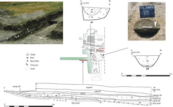
The ditch (24/66) was found to be at least 40m in length, ranging from c 1.3 to 1.7m wide and 0.5 to 0.6m deep (table 2), orientated south west–north east (figs 6 and 11). Its western terminal was located on the eastern edge of a lower-lying area of ancient wetland and approximately 5m west of the hoard. Its eastern end probably originated near the braided channels of the ancient River Snail, but this lay outside the area trenched and was therefore not confirmed. It was investigated by sections cut across it in three locations, plus a longitudinal excavation in the southern side of the ditch terminal which revealed a sub-rectangular, near-vertical-sided profile at the end, and a slight depression in the base (fig 12). The cross-section of the ditch showed a flat-based, steep-sided profile, with a primary infill of frost-talus chalk in the corners covered by a dark grey-brown silty clay with a high chalk (lump) content. Secondary fills graded from chalky silts to a silty sand with chalk pea grit in the upper (tertiary) fill, becoming lighter in colour towards the top of the sequence. Although burnt flint was found in all layers, it was predominant in the primary and tertiary fill episodes. Flint blades were found in these two layers, plus a thumb scraper in the primary fill (fig 18.23); waste manufacturing flakes were found in the secondary and tertiary fills. An unidentified concretion with mica-rich shaley surface was found in one of the secondary fills (45).
The main area of the excavation, with the plan of the Barleycroft Farm long- house superimposed over a feature plan

Sections and photographs of the hoard ditch (24/66)

This evidence would suggest that the ditch was never used for drainage, as the flat base and steep profile show little sign of water erosion, and the terminal was not designed to allow the water to flow into the wet area beyond. In fact its abrupt end, the depression in the base and the slightly more complex pattern of fills (including some charcoal) could indicate the presence of a post in this location. It was probably intended as a boundary ditch, which accumulated deposits through natural erosion of its upper sides and small soil particles that washed in from the surrounding land. The final fill contains sand and this could have derived from overflow of the ancient River Snail during high-velocity flooding. The burnt flint and few diagnostic flint tools, including residual artefacts, suggest that this ditch could be Bronze Age in date.
The pot containing the hoard appears to have been placed on to the base of this ditch, presumably within a pit cut through the infill sequence. Unfortunately, no evidence of the pit cut remained for recording in 2000 as the backfill of the 1960 excavation consisted of light brown silty clay, filling a slot 0.9m in width across the ditch. The implication is that the ditch was still visible in the landscape when it was chosen as a suitable location for burying the hoard, and it was presumably chosen because it would have been easier to dig through the silt fills rather than excavate a pit into the hard chalk. The depression of the partially filled ditch would have been visible and reasonably easy to relocate, with the hoard just five paces east from the ditch terminal. The interpretation of what Britton wrote in his 1960 report suggests that parts of a large vessel were used to line a pit that had been dug specially for the purpose of storing the metalwork, implying the container was incomplete when used for this purpose. However, the pit had already been excavated by the Houghton brothers by the time Britton arrived on the scene, and there is no known photographic evidence to show the pit, vessel and hoard in context. The 1960 excavation recovered further sherds from the vessel as well as metalwork in close proximity to the pit, and also alludes to scraps of pottery (from an old soil and ditch) which were not connected to the hoard.
Other ditches and linear features
Several of the other ditches ran parallel to one another and to a large rectangular flat-based feature (40/80) 4m wide and 0.6m deep, which extended for 52m in a south west to north-easterly direction (figs 6 and 14b; table 2). The fills of this large vertical-sided feature were a succession of greyish-brown clay and chalky silts. No burnt flint was found, but a whetstone of probable medieval type was recovered from within the fills. A 0.4m-wide channel leads out of this feature at its south-western corner (90), 0.54m deep and 1.16m long, with vertical sides and flat base; this was filled with similar deposits to those found in the large rectangular feature. These are therefore tentatively interpreted as a water tank or reservoir with overflow channel, and are probably of medieval or later date.
Ditch 38 ran parallel to the tank feature (40/80) on its southern side. It was 1.7m wide and c 0.8m deep with a flat base and steeply sloping sides. It ran for at least 50m and had two sets of fills: a primary deposit of chalky silt and a secondary one of soft silts with peaty inclusions (fig 12). Cut into the secondary fill was a U-shaped ditch (54/87), 0.8 to 1m wide and c 0.3 to 0.5m deep. Burnt flint was found in one area of the clay-silt fill of this recut. Ditch 38 was stratigraphically linked to the Bronze Age boundary ditch (24/66) where the two ditches intersected and it cut through the Bronze Age fills some 40m east of their western terminal. By the nature of its fills, association with the tank feature and its physical relationship (stratigraphically later than the Bronze Age), ditch 38 and its recut are also assumed to be medieval in date. In this same location a ditch (71) running north to south appears to have been cut by both ditches. A sherd from a plain handmade vessel of neckless ovoid or ellipsoidal form (suggested below as possibly deriving from a PDR Plainware or Decorated assemblage)Footnote 25 probably came from the fill (fig 18.76).
Ditch 96 ran parallel to the tank feature on its northern side; it was 0.63m wide and very shallow (0.07m deep), filled with a dark grey-brown chalky silt and some burnt flint. This is also assumed to be medieval in date because of its spatial relationship to the tank feature (40/80).
Of more potential interest to the prehistoric history of the site were two triple ditch arrangements, both apparently orientated north west–south east (fig 6). The first of these (104/105/106) was c 80m east of the eastern terminal of the tank feature and consisted of an original flat-based steep-sided ditch, 0.75m wide, cut by a shallow 2.6m-wide U-shaped ditch, which in turn was cut on its western edge by a 0.8m-wide U-shaped ditch. The fills of all were silty sands, but each was distinct in colour and compactness. Some 50m further east a second group consisted of a V-shaped ditch arrangement (8/117/120) some 2m wide and 0.8m in depth overall. The limited area in which this was exposed and investigated leaves little that can be said about the ditch complex, except that each ditch was filled by a very similar deposit of firm greyish-brown silty chalk (117), that yielded a small body sherd displaying along its rounded shoulder three parallel, deeply cut, narrow grooves (fig 18.117), which it is suggested below may derive from a vessel of the PDR Decorated tradition.Footnote 26 Other ditches of various shapes and sizes were found (mainly further east) but little of value to the present report can be added by their detailed description.
Pits, post-holes and rectangular building
An open area 7m wide was examined extending 14m south of the hoard location, and a zone of burnt flint c 2m wide was found running along the edge of the wetland in the western part of this area (figs 10, 12 and 14b; table 3). The flint band was so dense that it crunched loudly under the bucket of the JCB and was clearly visible as a dark grey and crimson colour. Within this open area were a number of pits and post-holes visible as dark fills cut into the chalk. There were also some spreads of soil and burnt flint that may have been features (probably more pits), but it was only possible to excavate and record a selection of these.
Two post-holes (61 and 69) located close to the hoard were investigated and proved to contain fills similar to the primary fills of the Bronze Age ditch (24/66). Burnt flint was found in the later infill of one of these post-holes. They were c 0.5 to 0.6m in diameter and cut c 0.25m deep into the chalk (fig 13). A further post-hole (31), of similar diameter but severely damaged by ploughing, was found at the southern end of the open area. Between these features, two smaller-diameter post-holes were found lying beneath a spread of burnt flint and soil (29/32). Context 29 yielded a tiny (3g) moderately abraded, plain body sherd in a coarse quartz-gritted fabric from a vessel of uncertain form and of unknown typological affinity. The two post-holes (34 and 47) were c 0.2m in diameter and filled with chalky silts and burnt flints. Several more features in this open area could have been post-holes but were not investigated, and another spread of burnt flint (25) could have masked more.
Sections and photographs of the fen-edge sequence and post-holes

With such limited evidence it is difficult to make conclusive interpretations, but if the two larger northern post-holes were seen as corner posts lying 6 to 7m apart, the rest of the possible post-hole configuration runs south-eastwards and could together form part of the ground plan for a rectangular building. A baulk lies in the area of the hypothetical northern wall, but by using the two corner posts as anchors, when the plan of the Barleycroft Farm long-house is superimposed,Footnote 27 an almost identical match to the arrangements at Isleham can be detected (figs 11 and 14b). The similarity of fill between these post-holes and the Bronze Age ditch to the north has already been mentioned, and the wider organization of the landscape should not be ignored. The western wall would have run parallel to the edge of the wetland, and burnt flints seem to have accumulated as a deposit against this hypothetical wall. This wall is exactly in line with the ditch terminal for the Bronze Age ditch (24/66), and the two northern corner posts are equidistant, at 2m from the ditch, presumably respecting its alignment and using it as a baseline from which its layout was determined.
(a) Excavation in progress looking east; (b) the completed excavation of the main area looking south

Along the trench to the east a number of other pits and post-holes were found. It is impossible to give any interpretation to these or any particular date based on the evidence of a single narrow trench, and those near the eastern end are more likely to be related to medieval activity rather than earlier periods. Within the fills of post-hole 100, however, small fragments of prehistoric pot were found, and near the eastern end of the trench a pit (5) produced a small, plain girth sherd which, it is suggested below, derives from a carinated bowl or jar of a type common in eastern English Plainware and Decorated assemblages (fig 18.5).
Palaeochannel, wetland and fen-edge activity
To the west of the possible rectangular building and the hoard, a low-lying area of dark peat existed between the excavation and the large circular enclosure investigated at Moor Farm, Fordham (fig 5). The surviving peaty area was about 180m wide east to west, and could be seen lying either side of a drainage channel that had been cut along the lowest part of the landscape. The presence of this wet area strongly suggested the proximity of localized fenland when the hoard was deposited, in spite of the fact that the main Bronze Age fen edge was c 1km to the north. In order to investigate this area and to obtain samples for palaeoenvironmental analysis and radiocarbon determination, the trench was taken approximately 15m into it (fig 10). A sondage was dug with the mechanical excavator (c 60m east of the drain and the lowest part of the area, 18m west of the edge of the wetland) to the base of the organic wetland sequence, and a 0.7m long column sample (peat monolith) retrieved. Bulk soil samples were also taken every 0.5m through the sequence for macrofossil analysis. In addition a hand-dug section was excavated for a distance of c 5m into the peat and silt deposits from the interface of the wetland with the chalk terrace on which the rectangular building was located. This hand-dug trench (50) (fig 13) went through the burnt flint layer on the edge of the wetland and provided a detailed record of the sequence that had lapped up against the dry land.
Peter Murphy provided a description of the wetland sequence, which he interpreted as a palaeochannel following his visit during the excavations (a more detailed analysis can be found below in Steve Boreham’s pollen analysis). The base consisted of degraded chalk rising through tufaceous silt to a broad deposit of brown humified peat, separated by a lens of laminated sand. The peat was overlain by alluvium, with a loam topsoil above, and the palaeochannel probably extended 1m below the earliest formation of peat. The full sequence exposed in this sondage was 1.33m deep, with the base of the trench being located within the tufa layer at 2.24m AOD.
On the edge of this palaeochannel, flooding layers were clearly evident as a series of grey-brown silty layers deposited over the chalk (fig 13). The alluvial nature of these were demonstrated by the fine silts at the top, but with a coarser and increasing sand content lower down the sequence. The middle levels (rather than the latest alluvial episode) in the zone, where they lapped the edge of the chalk, included a high percentage of fire-cracked and burnt flint. Some animal bone and charcoal, shells and five small pot sherds were recovered from these deposits. These included a Bronze Age flint tool (fig 18.77) and (from 52) six sherds deriving from a moderately abraded fragment of an Early Bronze Age urn (fig 18.52).
Soil, Pollen And Mollusc Analysis And Dating
The wetland sequence
A 700mm-long monolith from the Isleham hoard site, with a base at 2.24m OD, was recovered in September 2000. The stratigraphy of the sequence was:
• Top: 650–700mm buff silt (interpreted as alluvium)
• 400–620mm brown/black (upper) peat (transition 620–650mm)
• 320–380mm buff sand (transition 380–400mm)
• 150–300mm brown/black (lower) peat (transition 300–320mm)
• 50–120mm grey clay (transition 120–150mm)
• Base: 0–50mm cream-coloured tufa
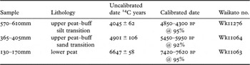
Three samples of sediment for bulk radiocarbon dating (14C) were taken from 130–170mm (grey clay–lower peat transition), 365–405mm (upper peat–buff sand transition) and 570–610mm (upper peat–buff silt transition). The samples were submitted to the University of Waikato Radiocarbon Dating Laboratory. Eight 1cm3 volumetric samples of sediment for pollen analysis were taken from the core at the following points: 80mm, 150mm, 380mm, 420mm, 480mm, 545mm, 580mm, 620mm. This sampling strategy included the basal grey clay, lower peat, upper peat and upper buff silt. The samples were prepared for pollen using the standard Department of Geography method involving the treatment of the samples with hydrofluoric acid to remove silicate material. The pollen residues were mounted on glass slides in silicon fluid and counted at ×400 magnification using a high-power stereo microscope. Where possible counts of 300 pollen grains were made from each slide.
Radiocarbon dating
The radiocarbon results from the Isleham hoard monolith are shown in table 4.
Radiocarbon dates from the sequence of wetland deposits

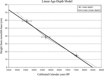
The radiocarbon dates were ‘in order’ (not reversed) and produced a plausible linear age-depth model. The implication of this is a sediment accumulation rate of c 150mm per thousand years. There is a disagreement between the linear age-depth model (fig 15) and the observed data, although this is only a slight difference. However, it means that the base (0mm) of the monolith might date from 8500–8700 years bp, and that the top (700mm) might represent 3600–4000 years bp. It is of course likely that each sediment unit has its own accumulation rate, and that this simple linear interpolation is inaccurate. Despite this, the dating of the main part of the sequence (150–590mm) is secure. If we take the start of the Bronze Age as c 4000 years bp, then it becomes clear that certainly most of the sequence preserved in the monolith had been deposited before that time. These sediments appear to record tufaceous (spring-fed) deposits at the beginning of the Holocene and a period of peat overgrowth spanning the mid-Holocene, starting at c 7500 years bp.
Graph showing the correspondence between 14C dates and sediment accumulation at c 150mm per 1,000 years

Pollen results
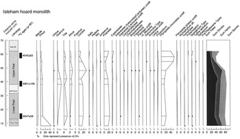
In general the pollen sequence is typical of a mid-Holocene vegetation succession from southern England, recording the rise of mixed-oak woodland (fig 16). The grey clay from the basal part of the sequence (80mm) is characterized by high frequencies (c 45 per cent) of pine (Pinus), with subordinate birch (Betula), hazel (Corylus), grass (Poaceae) and fern spores (Pteropsida). This is interpreted as an early Holocene assemblage, representing scattered hazel and birch scrub with stands of boreal woodland, in otherwise open grassland. A pool with open water c 2m deep is indicated by the presence of water-lily (Nymphaea); the presence of bur-reed (Sparganium) suggests that emergent marginal vegetation grew close by.
Pollen diagram

At the base of the lower peat (150mm) (7420–7620 cal bp), pollen of hazel and lime (Tilia) dominate the arboreal signal, accompanied by oak (Quercus) and elm (Ulmus). Pollen of grass and fern spores are abundant and there is a little herb pollen. This pollen spectrum indicates broad-leaved woodland on higher ground close by, and a shallow mire with some open water is suggested by the presence of pond-weed (Potamogeton). Emergent marginal vegetation is inferred from the presence of bur-reed.
At the transition of the buff sand and upper peat (380–420mm; 5450–5950 cal bp) oak has attained dominance, accompanied by hazel, lime and alder (Alnus). This mixed-oak woodland signal is that expected from mid-Holocene sediments and can be interpreted as representing a landscape clothed by closed-canopy broad-leaved woodland. The wooded environment is confirmed by spores of the polypody (Polypodium), an epiphyte of trees in damp places. Wet woodland (carr) is indicated by the present of both alder and willow (Salix). Pollen of sedges (Cyperaceae) and a variety of herbs suggest riparian and meadow habitats adjacent to an infilling fen. A small peak in reworked pre-Pleistocene spores suggests modest local erosion of soils at this time.
The pollen spectrum from 480mm in the upper peat is similar in many ways to the two previous samples, except that hazel reaches c 32 per cent and becomes more dominant, perhaps as an under-storey shrub in the oak woodland. This might represent a response to clearance or disturbance of the woodland.
At the top of the upper peat three samples (545mm, 580mm and 620mm; 4850–4300 cal bp) are characterized by the dominance of fern spores. Oak, lime, alder and hazel are all present in these samples, and woodland again indicated by polypody spores. Sedge, bur-reed and a range of herb pollen is also present. This assemblage seems to be dominated by a local pollen signal, and is interpreted as representing the succession of ferns and terrestrial plants onto the surface of an infilled fen.
The overlying buff silt has been interpreted as over-bank alluvial deposits, and could conceivably be much younger than the top of the upper peat. However, no evidence for sub-aerial exposure was seen in the sediments at the boundary of the peat and silt. (SB)
Molluscan summary
In order to try to see whether there was any connection between the palaeoenvironmental data from the wet area and the Bronze Age features discovered during excavation, soil samples from the fills that had contained the Bronze Age hoard (of ditch 24/66) were floated to extract molluscan remains. These were examined by Richard Preece of the Zoology Department at Cambridge, who reported that thousands of molluscs were available from the samples that had been processed.
In summary the results suggest a wet, open environment with one rare key species no longer found in Cambridgeshire and intolerant of prolonged winter cold that indicates a transient habitat between wetland and woodland, chalky/forest margins. The ditch may have been water-filled, as one species was more aquatic and its habitat is on floating vegetation. Other molluscs suggested scrubby, woody shade-demanding environments, as are often found in ditch contexts, as well as those that thrive in well-drained chalky soils.
Molluscan analysis
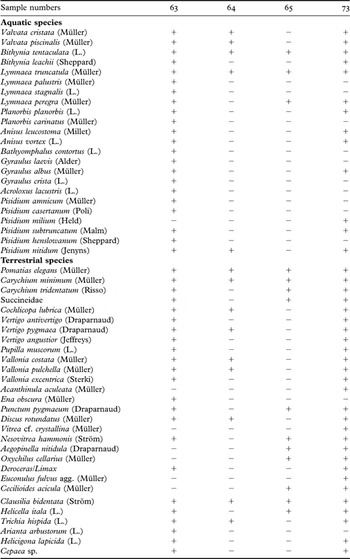
Four samples were analysed for molluscs. These were selected from six 2kg bags taken at 50mm vertical intervals as a column through the four fills of ditch 66. The samples were located 1.5m west of the hoard in the same ditch in which it had been placed. The sediments – which ranged from clayey silts at the base of the ditch, through chalky silts to sandy silts at the top – had been wet-sieved using a 0.5mm mesh. The fauna was rich, consisting of twenty-three aquatic and twenty-nine terrestrial taxa (table 5). Samples Islbahoo <7> 63 and Islbahoo <7> 73 yielded the most diverse assemblages, which included a substantial number of freshwater molluscs that would have lived in the adjacent river. The terrestrial species included hygrophilous taxa (such as Vertigo antivertigo, Succineidae) that inhabited marshland adjoining the river, as well as other species (such as Pomatias elegans, Helicigona lapicida and Vallonia excentrica) that would have lived on drier ground further away. The occurrence of Vertigo angustior is noteworthy, since this is now rare in Britain.Footnote 28 This species lives in transitional habitats that are neither very wet nor extremely dry and which are generally unshaded by trees. (RP)
Isleham molluscs

The Isleham Vessel
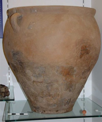
As reconstructed by the Moyses Hall Museum (fig 17), the ceramic vessel in which the hoard was discovered is a very large, wide-mouthed container (c 525mm high; c 450mm diameter at the mouth; c 220mm diameter at the base) with at least one strap handle springing from the bottom of a short everted neck and joining to the ovoid body. The rim is ‘thick and flattened’.Footnote 29 The vessel preserves a flat base, pinched out slightly externally Immediately above the base angle, Britton observed a ‘row of small holes’.Footnote 30 The outer and inner surfaces of the vessel are of variable colour, ranging from buff to light and dark grey. Britton recorded that the ‘paste is hard and rather gritty, with flint tempering … [and that] … its colour varies from buff to grey’.Footnote 31 During the analysis programme a further consideration of this ceramic vessel began to appear beneficial, and so David Knight kindly agreed to review the current understanding of it. (TM)
The Isleham hoard pottery container reconstructed. Photograph: courtesy of the Moyses Hall Museum

Vessel reconstruction
The author (DK) was not able to examine at first hand the jar in which the bronzes had been deposited and the following comments are based upon an assessment of the photograph reproduced here as fig 17 and observations made by Dennis Britton at the time of its discovery.Footnote 32 Additional specialist analysis is recommended to investigate whether all of the sherds that form part of the reconstructed vessel derive from the same pot and to assess the reliability of the reconstruction. Specialist analysis would also permit a more detailed characterization of the fabric, although the absence of breaks would limit the scope of further investigations. These analyses could usefully be combined with detailed specialist analysis of the pottery recovered during recent excavations in the vicinity of the hoard, with the particular aim of investigating similarities in vessel fabrics.
Typological parallels and affinities
Most of the surviving sherds derived from the lower body of the vessel and the author would share Britton’s concern that too little has survived of the upper profile to establish the vessel profile beyond doubt. The problem is compounded by the discovery of other pottery in the vicinity of the hoardFootnote 33 and, as noted above, by the difficulty of establishing beyond doubt that the reconstructed vessel does not contain sherds from more than one vessel.
The vessel in its reconstructed state may be compared with pots of the PDR Plainware tradition identified some thirty years ago by John Barrett.Footnote 34 The high-shouldered ovoid profile, combined with the flat base and the everted neck terminating in a simple ‘thick and flattened’ rim, may be paralleled widely in Plainware assemblages, and the pot was included by Barrett in his review of PDR pottery in eastern England.Footnote 35 Few examples approach the size of the Isleham container, but from the regional perspective it is worth drawing attention to a particularly close comparison (minus handles) from another East Anglian site near Barham, Suffolk.Footnote 36
Parallels for the strap handle which, in the reconstruction, is shown to spring from the base of the neck, are less frequent. Complete or fragmentary strap handles comparable to that retrieved from Isleham have been retrieved in association with Plainwares on a number of sites in southern England, but these are never abundant and the forms of the vessels to which they were attached remain largely a mystery. Examples include the Thames Valley site of Aldermaston Wharf, Berkshire, where a range of classic Plainware vessels was recovered from a pit together with a fragment of a strap handle thought to form part of the same assemblage.Footnote 37 Closer to Isleham, handled Plainware vessels have also been reported during excavations of a later Bronze Age double-ditched subrectangular enclosure at Lofts Farm, Essex,Footnote 38 providing useful evidence that handled vessels had formed a minor element of the Plainware tradition of eastern England.
The row of perforations above the base is extremely unusual and, to the author’s knowledge, lacks close parallels in any Plainware assemblage. An ellipsoid PDR jar from Green Lane, Farnham, Surrey, preserves a single perforation immediately above the base,Footnote 39 but searches of other PDR Plainware assemblages have so far yielded no examples with a row of perforations above the base. Neither have searches of other prehistoric ceramic assemblages from eastern England yielded close parallels, and these curiously placed holes rank as another unusual feature of this most remarkable vessel.
A relationship to PDR Plainwares would, on current evidence, imply a chronological range from around 1150 to 800 bc,Footnote 40 which would fit well with the date for the associated Wilburton metalwork. The OSL date seems on first sight rather early, but the date range of 1460 ± 230 bc at 1 sigma does, in fact, just overlap the proposed period of currency of the metalwork. (DK)
OSL dating of the vessel
Discussions were held with the Luminescence Dating Laboratory at the Research Laboratory for Archaeology and the History of Art, University of Oxford, to assess the practicality of thermoluminescence (TL) dating of the burnt flint. Dr E J Rhodes suggested, however, that it would be better to date the pot directly using optically stimulated luminescence (OSL). With the kind assistance of Chris Mycock of Moyses Hall Museum, a small sample was sent to the Oxford Laboratory in July 2002 and prepared and analysed by Dr Jean-Luc Schwenninger.
A subsample for luminescence dating was obtained by removing minute amounts of material from the central portion on the edges of the sherd, leaving no visible damage to the specimen. In order to determine the environmental dose rate, the concentration of radioactive elements within the sherd and the surrounding sediment was determined by neutron activation analysis (NAA) of subsamples (table 6). For the pot, a time-averaged moisture content of 5 ± 3 per cent was factored into the age calculation. For the sediment the measured water content was determined to be 20.35 per cent and an average value of 20 ± 5 per cent was used for making appropriate corrections to the external gamma dose rate. A burial depth of 40 ± 10cm was used in the calculations for the cosmic dose rate based on the knowledge that the sherd used for OSL dating was derived from the upper part of the ceramic vessel. Dose rate calculations incorporated dose conversion factorsFootnote 41 and an absorption coefficient for water content.Footnote 42 Estimations of the cosmic dose rate followed the calculations of Prescott and Hutton.Footnote 43 A total dose rate of 2.06 Gy/ka was calculated for the sample.
OSL dating results and radioactivity data (concentrations of radioactive elements were determined by neutron activation analysis)

OSL measurements were made using an automated single-grain system (Risø TL/OSL-DA15 reader) equipped with a bialkali photomultiplier tube. Sample irradiation was provided by a built-in sealed 90Sr/90Y source and luminescence was detected in the UV region using Hoya U340 glass filters (290–370nm). Optical stimulation was carried out by filtered blue diodes (emitting ∼410–510nm). Measurements were obtained using a modified single aliquot regenerative dose (SAR) protocol,Footnote 44 which incorporated a post-IR blue stage in which each OSL measurement is preceded by an infra-red stimulated luminescence measurement to reduce the effects of any residual feldspar grains.Footnote 45 The analyses of the results provided a mean palaeodose of 7.12 ± 0.05 Gy which translates into a mean luminescence age estimate of 3460 ± 230 years before 2002 (1460 ± 230 bc).
On typological grounds the hoard would seem to lie within the date range 1150–1000 bc; there is nothing post-Wilburton included in it. Thus the range of date for the pot obtained by OSL analysis could coincide at its late end with the date of the hoard established by typology. Alternatively the pot could have been an heirloom or ancient specimen that was used to contain the hoard when it was deposited in the ditch. No further sherds of this pot were recovered by our excavations within the ditch in 2000, and it therefore seems unlikely that the pot consisted merely of sherds that had become mixed into the ditch fills as part of rubbish accumulation.Footnote 46 (TM and J-LS)
Pottery, Animal Bone, Lithics And Bronze
Ten small sherds deriving from an Early Bronze Age urn and from at least three vessels that are attributed below to the PDR Plainware or Decorated traditions were submitted to the author for examination. A brief report on these is provided here, employing the descriptive conventions recommended by the Prehistoric Ceramics Research Group.Footnote 47 Fabrics were defined following examination of the sherds by eye and with a binocular microscope (×20 magnification) and are summarized briefly below (detailed sherd descriptions are in the archive). Variations in the size and frequency of inclusions are described using the following terminology:
• Frequency: rare (<3%); sparse (3–10%); moderate (11–25%); common (26–40%); abundant (>40%).
• Size: fine (<0.25mm); medium (0.25–1mm); coarse (>1–3mm); very coarse (>3mm).
Early Bronze Age
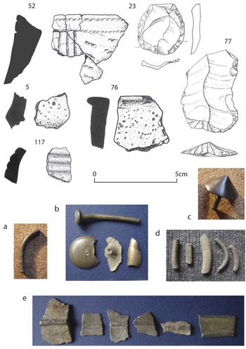
The burnt flint layer extending along the eastern edge of the palaeochannel yielded five (21g) moderately abraded joining sherds (fig 18.52) and another small body sherd (3g) in similar condition from an Early Bronze Age urn with an internally concave rim (52). It incorporates common, medium, moderately well-sorted angular grog fragments (plus occasional grog up to 3mm, containing visible shell inclusions), together with sparse medium, moderately well-sorted angular fossil shell. Both the inner and outer surfaces are oxidized to a buff colour, contrasting with the dark to light grey unoxidized core. The zone beneath the rim is embellished with an elaborate rectilinear pattern of linear twisted-cord impressions, combined with at least six closely spaced and diagonally aligned elongated impressions formed by pressing a short length of twisted cord into the clay prior to firing.
Too little of the vessel survives for its precise typological affinities to be established, but the sherds most probably derive from an Early Bronze Age collared or cordoned urn.Footnote 48 Such vessels were commonly embellished with comparable twisted-cord decoration,Footnote 49 although an exact parallel for the pattern on the Isleham urn has yet to be located. (DK)
Post-Deverel-Rimbury
The excavations yielded three handmade sherds that may be paralleled in PDR Plainware or Decorated assemblages from southern and eastern England.Footnote 50 All yielded variable quantities of fossil shell, which is unusual for later Bronze Age and earlier Iron Age assemblages in East Anglia, but not without parallel. Variable proportions of shelly pottery have been recorded in assemblages of these periods from several other sites in Cambridgeshire – notably Lingwood Wells, Cottenham,Footnote 51 and more recently FordhamFootnote 52 – and the few sherds described below provide a useful addition to our knowledge of early fabrics in the region.
• Small, moderately abraded body sherd (4g) deriving probably from the shoulder of a small bowl fractured immediately above the girth (fig 18.117; ditch 117). The shoulder profile suggests a pot with a pronounced rounded girth or a small round-bodied vessel, but too little of the wall survives for the profile to be established with certainty. Three parallel and closely spaced deeply cut grooves run around the shoulder, immediately above the girth. The sherd includes moderate, medium, angular fossil shell with rare coarse shell up to 3mm. All visible surfaces are unoxidized (black to dark grey).
• Small, slightly abraded girth fragment (2g) deriving from a plain carinated bowl or jar (fig 18.5; pit 5). The sherd incorporates sparse, angular, medium, moderately well-sorted fossil shell, together with rare, medium, angular flint and rare, fine to medium, sub-rounded quartz. The inner and outer surfaces are oxidized to an orange-brown colour, contrasting with an unoxidized dark grey to black core.
• Slightly abraded rim sherd (8g) from a plain bowl or jar of neckless ovoid or ellipsoidal (‘barrel’) form with a pinched-out rim of approximately triangular section (fig 18.76; probably from ditch 71). The sherd incorporates common, medium to coarse, poorly sorted angular fossil shell. It displays an oxidized exterior (buff), unoxidized core (dark grey to black) and an irregularly fired interior (buff and black).
Close parallels for the sherd with linear grooved decoration (fig 18.117) are difficult to establish, not least because of its small size and the difficulty of determining the body profile. It is most plausibly interpreted as part of a round-shouldered or round-bodied vessel, broken along the girth, and is best paralleled by examples of an East Anglian ceramic tradition characterized by round-shouldered and carinated bowls with multiple deep horizontal grooves around the shoulder. Vessels of this type, grouped by Cunliffe within his Darmsden-Linton ‘style-zone’,Footnote 53 first occur within assemblages spanning the transition from the Plainware to Decorated tradition between c 850 and 750 bc.Footnote 54 At Lofts Farm, Essex, for example, excavation of the outer ditch of a double-ditched enclosure unearthed Plainwares stratified beneath a rich Decorated assemblage, including sherds with horizontally grooved shoulder decoration above carinated girths.Footnote 55 Other round-shouldered and carinated vessels with horizontally grooved shoulder ornament were recorded in a Decorated assemblage retrieved from the lower fill of a well,Footnote 56 some comparing closely with the Isleham sherd.Footnote 57 A later date for this sherd would also be possible in view of the longevity of the Darmsden-Linton style,Footnote 58 but, with respect to its typological affinities, the link with this regional variant of the Decorated tradition seems securely based.
The remaining sherds derive from plain carinated and ovoid/ellipsoid vessels characteristic of PDR Plainware assemblages from a wide area of southern and eastern England,Footnote 59 and may provide additional material evidence for activity at Isleham during the period of deposition of the bronze hoard and its ceramic container. Plainware and Decorated assemblages are often difficult to disentangle, however, and a significantly larger collection of pottery would be required before we could demonstrate beyond doubt that these sherds derived from a Plainware assemblage rather than from a Decorated assemblage incorporating plain carinated bowls and other form elements derived from the ceramic tradition from which it had evolved.
Mention should be made finally of a small, moderately abraded plain body sherd (3g) from a handmade vessel of uncertain form that was recovered from the layer of burnt flint and soil extending along the edge of the palaeochannel (context 29; not drawn). This incorporates moderate, medium, sub-rounded to sub-angular quartz and is unoxidized with black surfaces and core. The sherd preserves no typologically diagnostic features and its relationship to the PDR wares discussed above, especially in view of its distinctive quartz-gritted fabric, must remain in doubt. (DK)
Animal bone
Animal bone was found in a range of features and fen-edge deposits. A total of 419 fragments (2,807g) were recovered, and although not all of these can be attributed a Bronze Age date, much of the assemblage came from the boundary ditch and other features related to the Bronze Age use of the site. A detailed study of this material has not been undertaken but the distribution and relative abundance of this assemblage would seem to be consistent with food residue, lending support to the evidence for domestic occupation at the site. The remains from Bronze Age features were generally smaller and much more fragmented than bones from the probable medieval features, and some evidence for cut marks and splitting of long bones was apparent. Easily identifiable species from the Bronze Age features included sheep/goat and cattle, mostly represented by teeth and parts of jaw and cranium, but with some long-bone and foot fragments. In addition, at least two horse teeth were present, as well as pig teeth and mandible.
Lithics
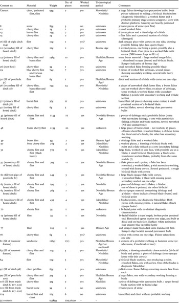
An assemblage of lithic tools, cores and waste flakes was recovered during the excavations and a summary of their provenance and characteristics is presented in table 7.
Worked lithic material from the 2000 investigation

Despite this site revealing predominantly Bronze Age archaeology, the flint assemblage revealed a much earlier history, dating from the Late Mesolithic period (6500 to 4000 cal bc). Incorporated into this small collection of lithics is a small blade technology, including bladelets and points.Footnote 60 Other diagnostic types are also reported upon from later periods.
Flint was examined from thirty-five contexts, weighing 1,562g. Within this assemblage are a number of pieces that are chronologically diagnostic, including a Bronze Age thumbnail scraper from context 23 (the primary fill of the ditch in which the hoard had been deposited) (fig 18.23), and an end scraper from the fen-edge deposits (fig 18.77).Footnote 61 In addition, further worked flints, diagnostic of the Bronze Age, have been found in contexts 22, 43 and 57 (secondary fill of the ditch in which the hoard had been deposited, in which some bronze fragments were also found). Other contexts from the hoard ditch (63, 64, 65 and 73) demonstrate that the flintwork from the ditch is typologically of Neolithic/Bronze Age date, as were the few diagnostic flints recovered from post-holes (contexts 31, 61 and 100), and so would not have been contemporary with the Late Bronze Age hoard. The range of tools suggests that a number of different economies were in practice in and around this site and is not untypical for the morphology of sites such as this.
The material from each of the contexts varies in type and lustre and may be the result of local importation of flint. The predominant material is cherty flint. This opaque white to blue material occurs as flaking (both primary and secondary) and as diagnostic tools. Dispersed within the assemblage are a number of primary and secondary worked flakes that are made from flint, usually from dark brown translucent material, possibly imported. The period range is from Mesolithic to Bronze Age, with the assemblage including a number of blades and bladelets that are probably of Mesolithic origin. The flaking technique, however, can be considered as simple, with much of the worked flaking being Neolithic and Bronze Age in date, utilizing larger cores and primary flakes. Flaking struck from these pieces comprises large secondary flakes, probably utilized as blades and points. This flake scarring is indicative of Late Neolithic/Early Bronze Age lithic production.
The weight and number of pieces varies per context. The majority of the flint dates from the Neolithic and Bronze Age. However, up to seven contexts contain Mesolithic flint (36 and 84, for example). This diagnostic flint appears to be mixed with later material. The presence of Mesolithic and Neolithic material occurring on a predominantly Bronze Age site may be the result of residual action (disturbance of earlier deposition during the Bronze Age) and clearly shows that Isleham is a multi-phased prehistoric site. The probable residual nature of the in situ lithic assemblage is partly mirrored in the diverse spread of unstratified material recovered from field walking around the site.
One also has to consider that some diagnostic material that is considered Mesolithic may have been produced by people practising hunting, fishing and gathering economies during the Neolithic or even the Bronze Age. (GN)
Bronze scrap
A total of 187 pieces of bronze, weighing 531g, were found from metal-detecting survey and excavation in 1998 and 2000 (figs 2 and 8; table 1) Although much of the bronze was found as small surviving fragments from large artefacts, nevertheless it has been possible to identify a number of partial objects, and to assign many of the other pieces to broad types.
The only pieces of personal adornment consist of a fine bracelet (3mm diameter) decorated with chevron pattern, and with three incised rings around the terminal end, and a pin head with ring and dot decoration (fig 18a). Two decorative studs or rivet heads were found – one conical and one of a domed shape (figs 18b and 17c). Martial equipment consists of various small parts of blades (some showing cut marks), many with ribs (fig 18e), and thirteen rivets from probable sword handles (figs 2 and 17d). There are seven plate-bronze fragments, possibly from cauldrons (fig 7e), and a number of other thin pieces of bronze and ribbed fragments too small to give a reasonable typological attribution. The vast majority of the assemblage, however, is derived from casting debris and smithing waste.
Artefact drawings and photographs

Discussion
The local context of the hoard
The relocation of the Isleham hoard actually places it just within Fordham parish at tl 63197253. The parish boundary appears to have followed an extinct course of the River Snail east and slightly uphill from the hoard location. This channel showed as a series of braided sand and gravel spreads alternating with dark organic-rich deposits within the trench. The interpretation for the apparent illogicality of a river uphill from the low-lying wetland area adjacent to the hoard is that during post-Roman times the rate of peat growth within the shallow valley of the Snail was such that, by the medieval period, it had covered the hoard site and extended east uphill, with the river migrating in the same direction on the edge of this tongue of fenland. The moated site at ‘Little Isleham’ would have been located close to the edge of the medieval fenland.Footnote 62 The river during the Bronze Age would have lain west of the hoard, within the low-lying wetland currently kept dry by a drain which effectively canalizes the course of the ancient river.
The hoard had been deposited either within an exceptionally large pot, or within sherds that had been used to line a pit cut into an infilled boundary ditch, immediately next to a rectangular building (a possible long-house), and within 5m from the edge of a tongue of fen. Burnt flint was found in abundance along the fen edge and within some of the fills of the features, including the ditch, but not within the primary fill of post-holes from the putative rectangular building. Burnt flint was found instead, spread along a potential wall-line of this building.
In the surrounding landscape there is considerable evidence for intensive activity of the same broad period as the hoard; it is not possible to be precise about the exact date or contemporaneity of this activity, but the density of surviving evidence gives an indication to suggest that it would have been fairly continuous during the Late Bronze Age. Settlement evidence has been recovered as well as large deposits of burnt flint adjacent to the ancient River Snail.Footnote 63 Bronze metalwork (reported by Fowler in 1949) and other artefacts, such as a miniature antler bow,Footnote 64 have been found, and a number of barrows are known from the vicinity.Footnote 65 In addition, close to the hoard there is an unusual circular feature some 70m in diameter which might once have formed a possible enclosed settlement. Few such ringworks are known from eastern England,Footnote 66 and a large gap appears to lie between West Harling, Norfolk, and Thrapston, Northamptonshire, or Sandy Lodge, Bedfordshire.Footnote 67 They vary in size from relatively small examples of around 30m diameter, such as the West Harling Enclosure III,Footnote 68 and one more recently excavated at South Hornchurch, Essex,Footnote 69 through those at Mucking North Ring, Essex, at c 60m and Springfield Lyons, Essex, at c 80m,Footnote 70 to the massive example in Yorkshire at Thwing.Footnote 71 The 70m diameter of the Fordham site would fit comfortably within this range, and the scale of the ditch (width and depth) compares well with excavated parallels (such as Hornchurch and West Harling). At Springfield Lyons, evidence for metalworking, in the form of clay moulds, was found in the ditch terminals, and the proximity of the Fordham enclosure to the Isleham hoard suggests a possible similar connection. Extra-mural settlements have been associated with such ringworks, identified from ceramic and metalwork distributions and other excavated evidence apparently congregating around them.Footnote 72 Without further excavation of the enclosure it is impossible, however, to confirm this interpretation.
In addition to pottery and animal bone, there is some structural evidence for settlement from the immediate proximity of the hoard (fig 11), evidence that relates to a series of post-holes that replicate part of the pattern for long-houses of the period.Footnote 73 Without wider open-area excavation, it is not possible to confirm this possible building for certain, but circumstantial evidence, such as the distribution of burnt flint against one wall and its orientation in relation to the boundary ditch, helps support such an interpretation. Within c 1km of the hoard site, roundhouses were found during investigations for the Ely to Isleham water pipeline,Footnote 74 and the pottery found during the excavations in 2000 are comparable to the 1997 assemblage.Footnote 75 The density of burnt flint beside the fenland corridor of the ancient River Snail testifies to the concentrated activity within the local area during the Late Bronze Age, and such associations of burnt flint with watercourses, settlement and metalwork all in close proximity has also been noted in other regions such as the West Sussex coastal plain,Footnote 76 as well as in the fens. In addition the small assemblage of pottery recovered from Isleham in 2000 would suggest a probable Late Bronze Age date can be attributed for the boundary ditch and field system surrounding the location of the hoard.
The general environmental development of the area has been verified by the pollen analysis and radiocarbon dating of the wetland sequence adjacent to the hoard site, comparing very well with the results obtained from a site within the River Snail c 1km further north.Footnote 77 From this we can conclude that the Late Bronze Age landscape would have been relatively clear of woodland, used for both pasture and arable agriculture, and that the wet area had been extensively colonized by ferns and terrestrial species of vegetation. The molluscs from the fill of the ditch in which the hoard had been deposited provided data from later in the Bronze Age to complement the earlier pollen evidence. The mollusca included a mixed fauna, with communities from the wet fenland area as well as from drier land, and a rare example of a species (Vertigo angustior) that likes neither too wet nor too dry conditions, but one that prefers unshaded areas.
Although no direct evidence was obtained for the environment contemporary with the deposition of the hoard, it would seem reasonable to assume that this had not changed dramatically from the conditions prevalent when the ditch was infilled. We can therefore suggest an open landscape with some woodland, proximity to a wet area, but predominantly a dry-land environment.
Isleham and its regional context
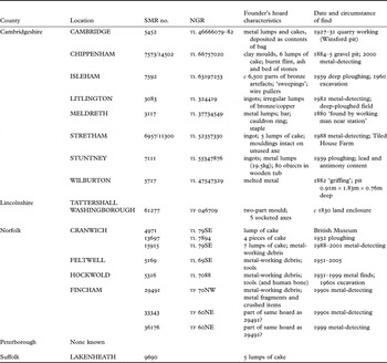
The Isleham ‘founder’s hoard’ is so-named because of the evidence for smithing revealed by unfinished objects, sweepings of tiny fragments from the smith’s floor, plate-ingots and cakes, clay moulds and wire pullers. The original report has photographs of the latter, as well as referring to casting jets and part of a mould.Footnote 78 There are a number of other Late Bronze Age founder’s hoards identified from the fens and South Cambridgeshire, and it is worth reviewing the context of these discoveries as a comparison to Isleham.
Distribution maps can be too simplistic for discussing the question of wetland or dry-land deposition, as a far more detailed local context is necessary to determine exactly what environmental conditions existed at the location of a hoard when it was deposited for such a dynamic environment as the fen edge. There are nonetheless some interesting aspects regarding the general distribution of founder’s hoards in the region, although using information from Historic Environment Records (HERs) is clearly tempered by the variety of ways in which sites have been labelled and described. Some will actually refer to founder’s hoards directly, as a discrete class in their own right, whereas others will only list hoards, or metalwork.
The concept of different types of hoard, and the interpretation given for their deposition, has been debated since modern archaeological study began. Founder’s hoards were concisely defined by Evans: ‘the hoards … appear to have been the stock-in-trade of some bronze-founder of ancient times, as they comprise worn out and broken tools and weapons, lumps of rough metal, and even moulds in which the accumulation of bronze was destined to be recast’.Footnote 79 I have tried to refine the search of fenland HERs by selecting hoards that included cakes, ingots, small scrap, broken-up items and mould fragments in order to obtain a slightly more objective corpus of comparable material, and have correlated this with published sources.Footnote 80 The results of this study suggest that founder’s hoards are largely unrecorded within the Lincolnshire (except possibly Washingborough and very recently in Tattershall), Peterborough, or northern Cambridgeshire fens: they appear in general to be a south-eastern fen and upland phenomenon.Footnote 81 Six definite founder’s hoards, and one possible one, are recorded within the Cambridgeshire HER (table 8). There is also a possible founder’s hoard from the River Snail in Fordham, just to the north of the Isleham hoard,Footnote 82 but it is possible that the ‘founder’s metal’ or ‘cakes’ referred to in this hoard actually came from the main site itself.
Late Bronze Age founder’s hoards

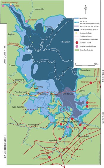
Closer scrutiny of the locations for these founder’s hoards does suggest a common thread in that most, if not all, are situated in the proximity of prehistoric routeways (fig 19). Those at Meldreth and Chippenham lie close to one of the routes of the Icknield Way (The Street Way or Ashwell Street),Footnote 83 which follows the springline at the base of the chalk hills. Stuntney lies close to the route that led to an ancient causeway to the Isle of Ely, and Wilburton lies close to the isthmus that connected the island with the Cambridge mainland during the Bronze Age and was a possible access route, now also followed by a modern road. The possible founder’s hoard at Tile House Farm, Stretham, lies adjacent to another of these causeways to the Isle, whilst that at Cambridge comes from a general area of a routeway heading north east towards the gravel isthmus that connected the mainland with the Isle of Ely until late Iron Age times. The two possible Lincolnshire founder’s hoards would also appear to be located near routes.Footnote 84
Fenland regional routeways and the distribution of founder’s hoards

In Norfolk there are ninety-four Late Bronze Age hoards and in Suffolk seventy-eight; many of those listed appear to be potential founder’s hoards. Only three Norfolk founder’s hoards, however, appear to be fenland ones (Hockwold, Feltwell and Cranwich), and in Suffolk only one (Lakenheath). A little inland to the south another founder’s hoard lay at Exning, through which Street Way (the summer route for the Icknield Way) passed;Footnote 85 further possible founder’s hoards are recorded near this routeway and that of the Icknield Way itself at Freckenham, Eriswell and Icklingham.Footnote 86 Another Norfolk hoard is set back a little inland at Fincham, and this is on the continuation of the Fen Causeway eastwards on its way to meet with the Peddar’s Way.
Isleham itself lies on a route that Cyril Fox identified as the Lark to Gipping corridor, a route that gave potential contact with the continent.Footnote 87 The route continued along the Rivers Lark and Snail towards the Isle of Ely via Quanea.
Dating the hoard
Fine dating for the deposition of the hoard remains uncertain. Current thinking based on typological grounds would place the artefactual assemblage within a period of 1150 to 1000 bc.Footnote 88 The results of the OSL dating of a sherd of the pot in which the hoard was found provides an age estimate of 1460 ± 230 bc, which brings the pot plausibly close to the dates suggested by the typological comparisons with Plainware vessels from Barham and elsewhere.
Conclusions
The hoard was deposited in the Late Bronze Age, within a feature that would have been easily discernible in the landscape, a partially infilled boundary ditch close to an area of former fen that was being colonized by terrestrial vegetation. There are potential parallels for this type of context, such as other hoards that have been found in ditches, perhaps within organic or ceramic containers, such as the two hoards from Runnymede,Footnote 89 or the palstaves and bracelet found in the enclosure ditch for South Dumpton Down, Kent.Footnote 90 These examples suggest there had been a deliberate act of selection and careful placement in their deposition, whereas the evidence from Isleham would not suggest a similar type of selective deposition. However, the circumstances of the 1959 discovery included emptying of the pit by the Houghton brothers before Britton arrived, and thus the exact arrangement of the hoard as it lay in the ground is unknown.
Burnt flint was found in abundance within the Isleham ditch infill layers, but whatever activity the flint was used for appears to have been contemporary with the occupation of a timber structure, a rectangular building and possible long-house. There is no evidence for salt-working in the vicinity and the worked flints that have been found are probably residual artefacts that have found their way into later features. Whether it was intended for recovery or not, the hoard remained in its hiding place, and over the succeeding centuries it became buried beneath peat as the fenland corridor along the River Snail expanded during the Iron Age and again within the medieval period.
In respect of a wider perspective, the Late Bronze Age founder’s hoard at Isleham can be studied in relation to others of a generally similar period, and their distribution suggests a possible association with prehistoric routeways. This hypothesis certainly deserves a more in-depth analysis than is possible within the present article, but the implications are worth raising now. It is perhaps not surprising to suggest such a link, as the workshop and stores of a bronzesmith would need to be located at convenient places to service his industry, an interpretation that has been presented in the past.Footnote 91 If we presume that a bronze artisan was at least semi-itinerant, then the sense in having a series of workshops and material stores handily located along the routes on which he travelled is self-evident. Such locations and itineraries might well have been passed on from one generation to another, but the replenishment of the raw material might have varied over time. There are no ore outcrops or smelting sites in the eastern region, and British sources for copper, lead and tin are located further west, in Cheshire and North Wales, Derbyshire and the Mendips, and Cornwall respectively. In many ways an easier source of raw material would have been provided by recycling local products,Footnote 92 and also through importation from the continent. The fenland rivers provided an easy access route from the North Sea via the Wash, and the Essex and Suffolk rivers – such as the Rivers Stour and Gipping – would have allowed other means of egress for shipments of continental scrap. Isleham is well placed to take advantage of all these communication routes.
Perhaps it would be no coincidence if, according to Edwardson,Footnote 93 the Isleham hoard contained twelve possible flesh-hook terminals, including a bronze shaft.Footnote 94 Flesh-hooks were a high-prestige item, with classes 3 and 4 often made in a technologically complex manner.Footnote 95 Although rare, they are an artefact that has been found elsewhere in the fens, at Feltwell and Eriswell, Little Thetford, where one of the routeways crossed by a timber causeway to the Isle of Ely,Footnote 96 and at Fengate, where the Fen Causeway crosses Flag Fen to the mainland. Although other mechanisms of distribution are possible, this could lend support to the supposition of itinerant smiths travelling established routeways, producing and receiving articles for the elite of society, and perhaps acting as the tangible distribution network for pan-European cultural traditions, such as feasting.Footnote 97 Although the Isleham hoard contains a mixture of high-prestige items it also contains more utilitarian tools, in contrast to many other non-founder’s hoards. The sheer numbers of swords, chapes, spearheads and ferrules, harness and vehicle fittings – and possible flesh-hooks – poses many questions. These valuable high-quality items, associated with elite use, including some from the continent, are found broken up, ready for melting down and reuse. In economic terms it would suggest that these articles had lost much of their value, that there was no need to repair or display them, nor to offer them to deities in ostentatious and public ceremony as has been suggested as explanation for many concentrations of metalwork, especially in wet environments. Does this perhaps indicate that, by the Late Bronze Age, these articles were, in fact, far more common than has been assumed previously, because of their relative rarity as survivals within the archaeological record? They were clearly items of great beauty and craftsmanship with intrinsic value attached, but the potential universality of social and symbolic significance with which swords and flesh-hooks (for example) have been imbued, as part of trends in modern academic thinking, may have dulled the keenness for alternative hypotheses. The theory of disposable wealth which has been suggested as another possible factor in the deposition of bronze hoards during a period of transition from predominance by one technology (bronze metalworking) to another (manufacture of iron) has offered a socio-economic explanation for such deposition.
But what of the negative evidence? How much greater was the potential volume of recycled luxury items that were re-smelted (and therefore lost from the archaeological record) than we have assumed until now? We will never know, and also we cannot be sure if such recycling was a factor derived from loss in value, and thus loss in prestige in ownership, or a more symbolic act to give rebirth to once greatly prized items;Footnote 98 the cycle of birth, death and rebirth transferred from the living world to the mercurial and magical world of metal.
Acknowledgements
This research has been made possible by the kind assistance of many colleagues and friends. Peter Northover has been supportive throughout and has supplied many useful details about the hoard and the circumstances of its discovery. He also offered to pay for the machine hire to open the trenches! Aileen Connor and Tony Baker were stalwarts of the excavation programme, and much of the success of the digging and recording of the site is due to their tireless efforts. Chris Montague and Roger Allison contributed their prowess with metal-detectors to locate the site accurately, and Chris devised the original metal-detecting survey that helped pinpoint the general area of the hoard. Phil Boon kindly allowed us access to fieldwalk, survey and excavate on his fields, and the County Farms Managers of Cambridgeshire County Council were instrumental in allowing the work to proceed and in financing it. English Heritage funded initial stages of the investigation through the support of Philip Walker, and the Regional Science Adviser, Peter Murphy, characterized the soil monolith. The sampling, analysis and radiocarbon dating of the pollen from the soil monolith was undertaken by Steve Boreham of the Department of Geography, University of Cambridge, and Richard Preece, Department of Zoology, examined the mollusca from the soil samples. Steve Macaulay and Rachel Fosberry of the Archaeological Field Unit processed the samples, Elizabeth Popescu commented on the draft text, and Jon Cane produced the initial illustrations.
The final plans, sections, fenland routeways and hoard distribution maps are all by Caroline Malim, and artefact illustrations are by the author. Chris Mycock, Curator of the Moyses Hall Museum in Bury St Edmunds, has been very helpful throughout the duration of this research, whilst Ed Rhodes and Jean-Luc Schwenninger, of the University of Oxford’s Research Laboratory for Archaeology and the History of Art, kindly took samples from the pot and processed them for OSL dating. Mike Allen was very helpful in advising on possible parallels for the pot, and I am grateful to David Knight, who wrote a reassessment of it as well as identifying several sherds of prehistoric pottery, and to George Nash, who undertook a detailed examination of the lithics and photographed the bronze artefacts for publication. Carol Allen, Matt Brudenell, Elaine Morris, Sarah Percival and Ann Woodward also kindly commented on the prehistoric pottery. Ben Robinson (Peterborough City Archaeologist), Sarah Poppy (Cambridgeshire), Alice Cattermole (Norfolk), Colin Pendleton (Suffolk) and Mark Bennet (Lincolnshire) assisted in provision of data from their respective HERs about the locations of hoards. Finally, my thanks to Stuart Needham for his useful comments on the draft text.