

CEREDIGION
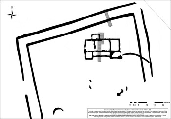
(1) Abermagwr (SN 6688 7416): trial excavation confirmed the presence of a small late Roman villa (fig. 2).Footnote 1 The building comprised a main block of three rooms, measuring 22 m east–west by 8 m north–south, with a veranda and two projecting alae or wings on the south side. A small room, measuring 5 m by 4 m, was appended to the rear of the building at a later date. The villa was roofed with local slate, cut with five sides and a fine point to form a highly decorative roof, common amongst villas in South-West England and the Isle of Wight. The walls were built of local stone on cobble foundations, though the upper storey, if such existed, may possibly have been timber-framed and plastered. The villa, fronted by a cobbled yard, occupied the upper north-east corner of the bivallate enclosure, strongly suggesting the presence of pre-villa structures, as yet undetected, in the upper north-west corner.
Key to numbered sections of Part I (Sites Explored).

Abermagwr Roman villa: plan of the villa and the northern part of the bivallate enclosure derived from geophysical survey, showing the location of two trial trenches excavated in 2010. (© Crown Copyright RCAHMW)
All the masonry from the wall bases had been systematically robbed, with trenches dug down to the clay and stone-packed foundations. Discarded quarried stone and quantities of complete and broken roofing slates from the robbing episodes characterised the upper levels of the site, intermixed with original collapse layers. Robbing may have occurred for the nearby Trawscoed mansion constructed in the sixteenth century, as place-name evidence indicates that the villa was probably a standing ruin into medieval times. No convincing evidence has yet been found of any tessellated floors or wall-plaster. The principal, central, room (Room 2) was floored with clay, as was the veranda, into which was set a stone-edged hearth at the west side. Evidence of several other hearths was uncovered in Room 2, comprising areas of intense burning on the clay floor. These may be attributed to later squatting activity, although one yielded a Roman cooking vessel, broken in situ, together with drops of lead, perhaps resulting from industrial activity.
Finds, which include sherds of black burnished ware and fine ware bowls from Oxfordshire, indicate occupation in the late third and early fourth centuries. Three coins of Constantine I, minted in the first quarter of the fourth century, were all found lying on or near late clay floor surfaces underneath the collapsed slate roof.Footnote 2
ISLE OF ANGLESEY
(1) Tai Cochion and Trefarthen Roman settlement (SH 4792 6560): geophysical survey detected an extensive Roman settlement on the shore of the Menai Strait (fig. 3). The settlement consisted of a road flanked by rectangular and sub-rectangular plots many of which contained rectangular buildings. A late prehistoric bivallate enclosure was also detected, adjacent to the road, at the western end of the settlement, suggesting that the Roman road adopted a pre-existing trackway.
Tai Cochion and Trefarthen Roman settlement: plan derived from geophysical survey. (Background map © Crown Copyright Ordnance Survey)

40 m by 20 m area of trial excavation was carried out in order to test the interpretation of the geophysical survey results. This revealed a 7.5 m-wide road of compacted gravel and silt and a rectangular building with dimensions of 20.5 m by 6.5 m. The building had light stone foundations, and a superstructure of wood and wattle-and-daub. The rectangular plots were delineated by shallow ditches, 0.6 m deep. Preliminary analysis of finds from the site indicates activity from the end of the first century until the late third century with a peak of activity in the second century.
The site presumably developed around a crossing point from Segontium Roman fort. It does not resemble the ribbon development of the vicus settlements found elsewhere in Wales. The closest parallels are the small towns and non-villa settlements found throughout much of central and south-eastern Britain.Footnote 3 This type of settlement was, however, previously unknown throughout most of Wales and the western seaboards of Britain.Footnote 4
MONMOUTHSHIRE
(1) Monmouth: (a) The Barton (SO 50803 12853): a trial trench on the frontage of the site revealed a ditch which produced early Roman pottery. The straight-edged, presumably V-shaped, flat-bottomed ditch, very similar to others found in the upper parts of Monmouth, was some 0.65 m deep and was cut into undisturbed natural. The sandy fill of the ditch produced a small assemblage of Roman pottery which included two very small fragments of samian ware from southern Gaul. These fragments support the suggestion that the ditch was a first-century military feature, possibly a drainage ditch, inside the Roman fort. There was a thin deposit of charcoal in the upper fill of the ditch together with lumps of burnt clay, presumably daub, and a large stone. A small gaming-counter was also recovered from the ditch fill.Footnote 5
(b) 20 Monnow Street (SO 50725 12762): trial excavation confirmed that the site lies over the frontage of an early Roman fort. The natural horizon was reached at 2.1 m below ground level overall, with the Roman ditch reaching a depth of 3.3 m below ground level. There was no sign of a rampart on the north-east side of the ditch which supports evidence from the adjoining property to the south-west that this was the front rampart of the fort. The V-shaped ditch ran at a slight angle across the trench and appeared to be steeper on the outside, south, edge, although the true angle was obscured as there had been a slump on the south-western half and a later post-hole had cut through the south-eastern side. The main ditch-fill produced two sherds of South Gaulish samian ware of the middle to late first century. There was an area of iron-working over the surface of the natural to the east of the ditch, including a hollow similar to the shape of the base of a furnace, although the fired clay was not vitrified as is often the case in bloomery furnaces. The slag was rather drossy and more like that from a smithing rather than a bloomery furnace. The slag from this feature appeared to be lightly spread over the back-fill of the Roman ditch, indicating that it was of a later period.Footnote 6
NEATH, PORT TALBOT
(1) Neath, Dwr y Felin School (SS 746 978): (a) the internal corner of the southernmost gateway tower of the north-east gate of the fort of Nidum was discovered (SS 7479 9780). It took the form of two substantial masonry blocks and part of its adjoining wall. Part of the associated road was also revealed.Footnote 7 (b) Immediately to the north of the Roman fort (SS 7464 9789), in an area presumed to be part of the vicus, a series of pits, post-settings, stake-holes and a probable timber structure, associated with evidence for nearby metalworking, were excavated. They lay on the eastern side of a former natural watercourse, with much more limited evidence for occupation on the western side. The date was Flavian-Hadrianic. However, evidence from this and previous excavations suggests that the greater part of the north-west quarter of the extramural area was undeveloped.Footnote 8
NEWPORT
(1) Caerleon (Isca): (a) Priory Field (ST 33930 90410): excavations continued on the site of a large courtyard horreum, or warehouse, on the dextral side of the praetentura at the front of the fortress.Footnote 9 The trench uncovered a total area of 480 m2, revealing approximately 70 per cent of the building's western or front range, including the main entranceway, a guard chamber with an opus signinum floor, a possible stairwell, and four small storerooms. The entrance passage had been resurfaced, with the flagging identified in 2008 lying on top of an earlier cobbled surface laid across the wall footings of the inner north–south wall. Most of the building's walls had been extensively robbed, but enough of the cobbled foundations survived to show that there was some variation in how these had been constructed. There was no evidence for a timber phase preceding the masonry building, although thin layers of burnt material in the northern part of the trench could have been either the remains of earlier occupation, or perhaps deposits associated with clearance of the site prior to construction. Further remains of later structures were identified, including another dry-stone or earth-bonded wall without foundations, apparently built up against the front wall of the store, but it is not yet certain if these are late or post-Roman in date. The excavations produced large quantities of finds from throughout the Roman period, including a scatter of at least 40 pieces of military equipment that lay above a beaten-earth floor in one of the storerooms. These objects were block-lifted and are currently being excavated in the laboratories of the National Museum of Wales, although it is already apparent that among them are pieces of lorica segmentata as well as fragments of bronze parade armour.Footnote 10
(b) Broadway Farm (centred on ST 338 902): geophysical surveys of an area of approximately 9 ha to the south of Broadway Farm, between Broadway and the River Usk, revealed Roman structures over most of the area of the raised gravel terrace (fig. 4).Footnote 11 These buildings can be divided, from west to east, into four zones: (i) from a point approximately 100 m north-east of the quay excavated in 1963,Footnote 12 and extending for at least 230 m towards the fortress, the south-east side of Broadway was marked by a development of buildings, mainly of strip form, and running back some 50 m from the road frontage. Close to Broadway Farm, this roadside development was bounded to the south-east by a road on an oblique alignment, oriented towards the west gate of the fortress. (ii) To the east of the oblique road, large masonry buildings, imaged very strongly by the gradiometer survey, cover an area of approximately 100 m by 120 m. They include what is interpreted as a large courtyard, approximately 40 m square, with surrounding portico. This is bounded to the south by a range of large rooms, to the west by a smaller courtyard, to the east by further buildings obscured by spoil, and to the north by what may be a large basilican structure. These features are on the same oblique alignment as the two bath-house fragments uncovered in 1926–27 and the monumental entrance excavated in 1955 (Building D). The extent of this complex corresponds broadly to the ‘quadrangular area’ which Nash-Williams recognised to the south of his 1955 excavation.Footnote 13 (iii) East of these structures is a zone, approximately 60 m wide, with rather poor imaging in the geophysical surveys, corresponding to an area in which it is believed much of the spoil from the 1926–27 amphitheatre excavations was dumped. Sufficient traces of structures were imaged to indicate that this zone was also covered by buildings, although of currently unknown plan. (iv) The eastern part of the area shows evidence for a large structure comprising a courtyard approximately 80 m square, with ranges of rooms on the north and west sides.Footnote 14 The courtyard contains at least one internal structure. Despite the size of this structure, the geophysical anomalies associated with its walls are of rather low amplitude, perhaps suggesting that there is little occupation debris associated with the structure, or that the walls were of rather modest construction. To the east of the courtyard a zone close to the bank of the Usk with strong magnetic anomalies was subsequently investigated with two test trenches (see (c) below).
2007 and 2010 magnetic gradiometer surveys of Broadway Farm, Caerleon, greyscale −9nT (black) to +9nT (white), with known and interpreted Roman structures. (© GeoArch)

The evidence for Roman buildings stopped abruptly at the foot of the elevated terrace. The survey revealed multiple small ditches on the floodplain immediately to the south, at least some of which are likely to be of Roman date and probably indicate small-scale agricultural or horticultural activity.
The opportunity was taken for the examination of recently-cleaned sections in drainage ditches running across the floodplain within the surveyed area and to its south. These showed thin dark deposits rich in Roman pottery, possibly cultivation soils, intercalated between two units of flood-plain silt, within an embayment in the margin of the terrace to the south-west of Broadway Farm (corresponding to the area divided by the small ditches described above) and bounded to the south by a curvilinear boundary marked as a trackway on the nineteenth-century OS map. Further southwards onto the floodplain, the dark deposit was absent and the upper, post-Roman, floodplain deposit lay directly on the lower, pre-Roman, silt. The boundary between the two silts could, however, be traced throughout the drainage ditch system, with a fairly constant elevation of 6.0 m to 6.21 m OD. At a point (ST 338 898) 90 m to the west of the Roman ‘street’ reported by Boon from a section in the bank of the Usk,Footnote 15 there was a substantial thickness, up to 0.5 m, of gravel above a layer of large flagstones that rested on the top of the lower silt. This deposit produced a small quantity of Roman pottery and tegulae, including one with a legionary stamp. An interpretation as a flood defence of probable Roman date appears more likely than as a road. A possible continuation of the gravel bank was observed in another ditch 270 m west-north-west. Smaller gravel deposits, again locally associated with finds of tegulae, occurred 180 m to 240 m south of the courtyard building (see (ii) above) and may represent raised trackways across the floodplain. The apparently simple stratigraphy across all the available sections on the floodplain indicates that there has been no migration of the Usk across this region since a pre-Roman period. There has been one previous radiocarbon date indicating a Neolithic age for an organic deposit close to the top of the lower floodplain silt,Footnote 16 suggesting the stability of the meander may be very long-lived.Footnote 17
(c) Southern canabae (ST 339 901): two 4 m by 2 m test-pits were excavated across the strong linear magnetic anomaly running alongside the west bank of the River Usk (see above). A narrow wall constructed of clay-bonded tegulae fragments was located in both test-pits. The tegulae had been deliberately broken along their lengths and then laid so that the intact edge-ridges formed both faces of the wall, while the wall's core was packed with clay and smaller fragments of broken tile. Nine courses of this wall were revealed, but it continued below the base of the excavated test-pits. The ground on the landward, western, side of the wall appeared to have been made up with large quantities of clean river clays, while the side facing the Usk produced evidence for the dumping of rubble and domestic or industrial debris into the river channel. The rubble in the northern test-pit was overlain by a surface of roughly-hewn stone flagstones. Assuming that this wall, and its associated deposits, account for the geophysical anomaly, it must have extended for at least 90 m towards the fortress. At present it is believed that the structures identified in these test-pits are the remains of a riverside quay and projecting landing-stages that formed part of a port complex at Caerleon.Footnote 18
PEMBROKESHIRE
(1) Wolfscastle, Upper Newton Roman villa (SM 9497 2648): a small excavation, adjacent to the 2006 excavations, was carried out in the expectation of more evidence of a building.Footnote 19 However, with the possible exception of several fragments of possibly Roman roof slate, no artefacts or features were revealed to suggest that this was the location of a Roman villa. Although the excavation results do not suggest a villa stood in the excavated location, agricultural activity and past stone robbing could have spread material from a villa site some distance from its original location. The possibility, therefore, remains that there was a Roman building near by. This possibility is supported by the results of another geophysical survey of the surrounding area, which identified several additional features to the south of the excavation areas, including a previously unknown sub-oval enclosure, and to the east several linear features that may suggest the remains of buildings and enclosures.Footnote 20
POWYS
(1) Caersws, New House (SO 0380 9140): geophysical survey revealed what appeared to be a rectangular enclosure immediately east of New House.Footnote 21 An excavation in an adjacent areaFootnote 22 demonstrated the presence of a series of ditches, gullies and pits which, in conjunction with the results from the geophysical survey, suggest potentially significant activity. Although no dating evidence was recovered, the V-shaped profile of one ditch, together with the rectilinear nature of the features, could suggest a Roman date.Footnote 23
(2) Four Crosses, Eagles Glen (SJ 2694 1893): pre-planning evaluation excavations revealed a series of shallow ditches and gullies of likely Roman date, probably associated with a field-system identified to the south and east through earlier aerial reconnaissance and excavation. Archaeological excavation of foundations produced further, albeit limited, evidence for activity in the area, although without any conclusive indication of the date. Apart from a range of post-medieval pottery from later deposits and features, the only artefacts recovered consisted of two possible hobnails and two small sherds of pottery, all of which could be Roman in date, although the pottery fragments were too small to allow a positive identification. The shallow gullies and pits were of a similar nature to those revealed during the evaluation, and it is not unreasonable to assume that the two sets of features might be related.Footnote 24
(3) Nantmel (SO 019 665): aerial reconnaissance recorded earthworks of two small Roman camps or practice works, one well-preserved and one fragmentary, lying some 335 m south of The Gaer, Dolau, defended enclosure.Footnote 25 The main camp is 27 m square, with a broad rampart, rounded corners, and central gateways. The second lies just to the south-east but only the northern part survives. The occurrence of these two Roman camps so close to The Gaer, Dolau, may be seen to support the idea that this larger earthwork is indeed Roman.Footnote 26
SWANSEA
(1) Llangennith, Lower Hardings Down Farm (SS 448 905): excavation of one of the more complete rectangular structures was finished.Footnote 27 This building, which had been badly damaged by ploughing, was 3.8 m wide and 22 m long externally. It was divided into three unequally-sized chambers. The floor surfaces, in places rubble sealed, were usually identifiable as a brown layer containing charcoal, burnt clay and occasional bone. Two post-holes were found at the gable end: one in the north-eastern corner and one adjacent to a likely doorway. A spread of crude cobbling lay inside and outside this entrance. No tiles were found and the roof was, therefore, probably of thatch or turf. A small quantity of metal-working debris was recovered.
A second partially rectangular structure and a small ‘banjo’ enclosure in the same field were also examined, although severe plough damage made excavation difficult. The structure appeared to have been 4.5 m wide externally, its length was not determined. Three post-holes, two positioned in the corners of the structure, were excavated. The ditch of the enclosure had a U-shaped profile and was 1 m wide and between 0.6 m and 0.7 m deep. The fill of the ditch was brown and gritty in composition with some medium-sized stones. In contrast the natural, into which the ditch had been cut, was a uniform, stone-free, dark yellow-brown clay.Footnote 28
NORTH OF THE ANTONINE WALL
HIGHLAND
(1) Belladrum (NH 52 41): ten denarii, the latest of Antoninus Pius, from a scattered hoard.Footnote 29
MORAY
(1) Birnie (NJ 210 585): the concluding season of excavationsFootnote 30 on this Iron Age settlement produced a single Flavian as, sherds of samian and coarseware, and further denarii from the scattered hoard.Footnote 31
ANGUS
(1) Cardean (NO 289 460): gradiometer surveyFootnote 32 of the fort and environs (fig. 5) revealed what is probably a series of barrack blocks in the south-eastern half of the fort, with hints of similar in the north-west; magnetic noise in this area suggests industrial activity, but this could be much later. An intriguing anomaly north-east of the fort might be a building.Footnote 33 The southern annexe was magnetically quiet.
Gradiometer survey of Cardean fort. (By courtesy of Dr P. Morris)

PERTH AND KINROSS
(1) Inchtuthil (NO 125 397): (a) geophysical surveyFootnote 34 of the stores compound (or ‘redoubt’) east of the fortress revealed no internal features, but extensive pitting was confirmed in the temporary camp to the south-west. The small rectangular enclosure on the tip of the promontoryFootnote 35 appears to lack entrances on three sides, with no ditch at all on the eastern side, casting doubt on identification as a camp. (b) Women's Knowe (NO 1279 3968): a radiocarbon date of 20 b.c.–a.d. 130 was obtained on human remains from this tumulus, which lies immediately outside the eastern rampart; interpretation is complex, but one possibility would see it as a Roman burial contemporary with the fortress.Footnote 36 (c) Delvine Gardens (NO 12890 39415): a watching-briefFootnote 37 immediately south of the ‘redoubt’, adjacent to the road line, found no surviving trace of Roman remains.
(2) Lintrose (NO 2187 3779): an evaluationFootnote 38 within the marching camp found no traces of Roman activity, nor of a linear earthwork recorded on early maps.
(3) Woodhead (NO 144 347): excavationFootnote 39 of this double-ditched, slightly sub-circular site (26 m in diameter) revealed two V-sectioned ditches with a single entrance to the north-west; four features in the interior form a slightly irregular square c. 4 m across. This is best interpreted as a watch-tower similar to those at the southern end of the Gask system,Footnote 40 with an excellent outlook over Inchtuthil and the tower at Black HillFootnote 41 to the mountains of the Highland fringe (fig. 6). No finds were recovered.
The Woodhead watch-tower. (By courtesy of Dr D.J. Woolliscroft)

STIRLING
(1) Doune: (a) (NN 7280 0132): excavationFootnote 42 in the north-east corner of the fort revealed remains of buildings, the via sagularis and the defences (fig. 7). The triple ditches had been partially backfilled when the fort was abandoned. The turf base of the rampart was 6 m wide, with revetting cheeks. Evidence of iron-working and a timber building lay against the rampart. Remains of the via sagularis were rather scattered, with a cobbled core and extensive gravel spreads to either side. To the south was a timber building (18.2 by 9 m) aligned north-west–south-east and split into five pairs of rooms. Drains in the more southerly rooms suggest identification as a cavalry barrack of unusual plan. Part of an adjacent building, apparently separate but on the same alignment, ran out of the trench to the east. Deep secondary pits had been dug into many of the rooms while the building was still standing. Among a rich range of finds, over 130 clay slingshots and a remarkable large harness mount decorated with ‘mirror-style’ Celtic art were of special note. (b) (NN 727 012): geophysical surveyFootnote 43 over the undeveloped part of the site confirmed triple ditches ran round all sides of the fort and located the south-west gate; its position suggests the fort faced south-east.
Excavations in the north-east corner of Doune fort. (From a plan supplied by Headland Archaeology)

FIFE
(1) Kirkton Barns (NO 45 26): 16 denarii from a scattered hoard were recovered,Footnote 44 the latest of Marcus Aurelius. Cropmarks testify to later prehistoric settlement in the vicinity.
THE ANTONINE WALL
WEST DUNBARTONSHIRE
(1) Old Kilpatrick, 20 Kirk Crescent (NS 46085 73238): a watching-briefFootnote 45 immediately north of Old Kilpatrick fort found a few sherds of samian and coarseware in a disturbed context, but no structural remains.
EAST DUNBARTONSHIRE
(1) Bearsden, 1 Glenburn Road (NS 54154 72134): a watching-briefFootnote 46 immediately north of the Wall located no Roman remains.
(2) New Kilpatrick, 33 Boclair Road (NS 5557 7224): a watching-briefFootnote 47 immediately south of the Wall located no Roman remains.
(3) Auchendavy (NS 6788 7485): a watching-briefFootnote 48 c. 150 m ESE of the fort revealed no Roman remains.
FALKIRK
(1) Castlecary (NS 7900 7818): trenches were excavatedFootnote 49 in an area where fieldwalkingFootnote 50 had produced a scatter of box-flue tile fragments just south of the fort. A clay raft over peat formed a causeway c. 9 m wide supporting the main road running NNW–SSE over an extensive moss;Footnote 51 survey evidence suggests it may also have carried an aqueduct for the bath-house. The fieldwalking finds had been displaced during railway construction, but box-tile fragments within the clay raft represent debris from building the bath-house, suggesting its construction (or repair) was contemporary with establishing this road. Subsequently, material (including Antonine pottery) was dumped to consolidate the causeway.
(2) Falkirk: (a) Woodside House, 37 Arnot Street (NS 8902 7963): a trial trenchFootnote 52 confirmed the location of the Ditch at this point. (b) Elgin Place (NS 8903 7961): trial-trenchingFootnote 53 just south of Woodside House confirmed that the Ditch turned to the south for an easier descent into the valley of the East Burn.
(3) Mumrills, Fort Knowe (NS 9180 7936): two small trenchesFootnote 54 exposed part of the south rampart (of puddled clay with a stone kerb) and via sagularis, a road perpendicular to this, and part of a building, probably a barrack block, with a hearth.
SOUTH OF THE ANTONINE WALL
CITY OF EDINBURGH
(1) Cramond, 45B Cramond Glebe Road (NT 1892 7690): test-pittingFootnote 55 within the south-west corner of the fort confirmed the presence of well-preserved Roman deposits.
EAST LOTHIAN
(1) Inveresk: (a) Lewisvale Park (NT 3508 7212): excavationFootnote 56 under the former cricket pavilion on the east edge of the park exposed part of a sub-rectangular sunken feature aligned north-west–south-east, 6.1 m long, at least 4.1 m wide and 0.65 m deep. Buried face-down at its north-west edge were two intact altars, both dedicated by the same person (fig. 8).Footnote 57 One is dedicated to Sol and bears a bust of the god, his pierced eyes and radiate crown allowing light to shine through from a recess carved in the rear; the capital carries busts of the four seasons. The other is dedicated to Mithras, with imagery linked to Apollo (lyre, plectrum and griffin) and sacrificial implements carved on the sides. Close by was an altar base. This sunken feature may be a timber-built mithraeum. A ditch and gully lay to the north, along with a scatter of other features, some prehistoric. (b) Brunton Wireworks (NT 3428 7224): evaluationFootnote 58 immediately to the north of the fort revealed a range of Roman-period features. A rich midden deposit overlay a series of ditches (perhaps from field-systems) and cobbled features of uncertain character. A cremation burial lay adjacent to one ditch.Footnote 59 (c) Kirkpark (NT 34045 72235): evaluationFootnote 60 immediately west of the former Wireworks revealed areas of cobbling and gullies associated with Roman finds.Footnote 61 (d) 2 Grannus Mews (NT 34563 71963): a watching-brief on the southern edge of the vicus Footnote 62 revealed no Roman remains. (e) 3 Smeaton Grove (NT 3495 7150): further evaluationFootnote 63 revealed a large pit containing Roman pottery. (f) 40 Carberry Road (NT 35040 71250): an evaluationFootnote 64 close to the known field-system found the area was heavily disturbed, and no Roman remains were located.
Altars from Lewisvale Park, Inveresk, in situ. (By courtesy of AOC Archaeology)

SCOTTISH BORDERS
(1) Castlecraig (NT 1244 4437): monitoring of small-scale stripping within the temporary campFootnote 65 located no Roman remains.
(2) Channelkirk (NO 48012 54537): an area within the temporary camp examined in a watching-briefFootnote 66 proved to be heavily truncated, and no remains survived.
(3) Kippilaw (NT 55 29): a hoard of 79 denarii to a.d. 207 and a single dupondius of Marcus Aurelius was foundFootnote 67 in a stream valley. ExcavationFootnote 68 indicated the area had been drained in the Improvement period, and the hoard scattered by cultivation. A high proportion of the coins are Severan, including die-linked groups which suggest they were military pay; a connection to Severan military activity in the area seems likely.
DUMFRIES AND GALLOWAY
(1) Lochrutton (NX 893 731): inspection of a 1984 CUCAP photoFootnote 69 revealed two conjoined temporary camps occupying a low rise to the west of Lochrutton, together measuring c. 340 m ESE–WNW by c. 290 m, with several conjoined, possibly associated annexes to the WSW. RCAHMS aerial survey in June 2010 added further detail.
(2) Kirwaugh (NX 406 549): inspection of a 1984 CUCAP photoFootnote 70 revealed a Roman fortlet with a triple-ditch system situated on a bluff above the south bank of the River Bladnoch.Footnote 71 Geophysical surveyFootnote 72 showed it measures 75 m NNW–SSE by 63 m over the main ditch, with opposed entrances on the short sides and an additional inner ditch on the more vulnerable western half. An outwork (or outermost ditch) provides a staggered gap at the SSE entrance, and runs off at an angle to the north (fig. 9). There are hints of a rectilinear building in its eastern half. Metal-detector surveyFootnote 73 produced a Roman-period terret but no closely datable finds; the unusual outworks might suggest a first-century date.Footnote 74 It is the first evidence of permanent Roman occupation on the Machars of Wigtownshire, and poses questions about the nature and location of Roman activity in this area.
Magnetometry survey of the Kirwaugh fortlet. (By courtesy of Dr T. Poller)

SOUTH TYNESIDE
(1) South Shields fort (Arbeia) (NZ 365 679): excavation continued in the area opened last yearFootnote 75 outside the southern angle of the fort (fig. 10). At the north-west side of the area, at a distance of 30 m from the south-west fort wall, was found the corner of a building. The walls were of clay-bonded sandstone and probably represented a 9 m length of the side wall and 2.2 m of the rear wall of a strip-building fronting onto a road known to lie 40–50 m south-west of the fort, running north towards its south-west gate. The interior contained a deposit of burnt daub from some element of the superstructure. A 4.5 m-wide yard of rough paving and metalling separated the building from a WSW–ENE-aligned road, partly uncovered along the south-east side of the excavation area. This was accompanied on its north-west side by a gully c. 0.5 m wide and 0.3 m deep. The road had a reasonably long period of use: it had been resurfaced at least twice and the gully filled and completely recut at some time.
South Shields: plan of the 2010 excavations.

If projected straight ENE the road would intersect with the ditches at the west angle of the extended Severan supply-base and fort. The gully, however, had a slight curvature to the east and the road probably curved in this direction to avoid the ditches. To the west the road probably formed a T-junction with the road south-west of the fort already mentioned. The road perhaps linked the south-east gate of the extended fort (the only way in and out of the accommodation part of the fort) with the vicus area outside the south-west gate, the latter only giving access to the supply-base part of the fort. As such the road would be a Severan introduction.
The terminal of a ditch running in from the north-west for a distance of 5 m, 3–3.2 m wide and 0.7 m deep, with gently sloping sides and a flat base 0.75 m wide, was found in the eastern part of the area. This probably represents an outer defensive ditch along the south-west side of the extended (Severan) fort, 24 m distant from the fort wall, possibly to be equated with Ditch C found during excavations in 1985–87 outside the south-west gate.Footnote 76 The ditch terminal had been dug to respect the WSW–ENE road just described. This confirms that the road was contemporary with the extended (Severan) fort and supply-base. The ditch had been dug through earlier stone structures which will be examined in 2011.Footnote 77
Lying on the road was a spread of demolition material which contained fragments of tubuli covered with opus signinum and therefore from a bath building. None of the pottery or finds from the plough-disturbed demolition levels associated with the building and road was later than the third century. However, the pottery in the ditch terminal indicated that this had remained open until the late fourth century. The ditch had never been extended across the road line, which may imply that the WSW–ENE route remained in use in the fourth century, but any surfacing of this date had been ploughed away.
NEWCASTLE
(1) 1–7 Westgate Road and Arches 23/24 Queens Lane (NZ 2497 6387): excavations conducted ahead of service installations as part of a refurbishment scheme for a series of accommodation arches associated with the railway viaduct east of Central Station. Six main sub-phases of Roman activity were identified, spanning the period between the late second/third century and the late third/fourth century, with the remains likely to be within the vicus of Pons Aelius fort. The first four Roman sub-phases represent activity and structural development associated with the construction and usage of a roughly north–south-orientated street, with remains of street frontage buildings recorded. Current knowledge of the location and layout of the fort suggests that this street lay c. 25–30 m beyond the west wall of the fort, although this has never been identified. Activity in the final two Roman sub-phases post-dated disuse of the street, with the final sub-phase associated with the use of another street orientated east–west. If the proposed line of the west wall of the fort is correct, this later street lay only c. 10–15 m to the west of that wall, although given its position it probably did not run towards a west gate, if one existed. The later street probably dates to the third or fourth century, a period which earlier excavations have demonstrated witnessed redevelopment within the fort, with some buildings being rebuilt and resurfacing of the via praetoria and at least one of the intervallum streets.Footnote 78
NORTHUMBERLAND
(1) Gilsland (NY 6430 6618): a small evaluation trench east of Gilsland village was excavated in advance of improvements to access on the Hadrian's Wall Path National Trail. It revealed the north face of Hadrian's Wall. This was located at a depth of 0.38 m below the ground surface and comprised an upper course of roughly squared stones, measuring a maximum of 0.38 m by 0.35 m by 0.19 m in size, tapering slightly towards the Wall core. This had been laid upon a foundation course of roughly shaped sub-rectangular masonry, measuring up to 0.50 m in length. The post-medieval boundary adjacent to the trench had evidently been constructed directly on top of the southern side of Hadrian's Wall, and followed its line. The wall was covered by a permeable membrane prior to backfilling the trench, and the post for the new gate was installed immediately to its north, leaving the masonry in situ.Footnote 79
(2) High Rochester (Bremenium) (NY 8321 9858): two trenches and three test pits excavated in the south-western part of the fort interior showed that significant Roman military remains survive in a part of the fort previously thought to have been largely devoid of such remains. Trench 1, in the scheduled area of the fort, uncovered the remains of substantial walls of Roman origin at a very shallow depth. The date of origin and function of these buildings was not established, although their substantial nature is suggestive of something other than barracks and the presence of associated burnt remains implies domestic use, or possibly a bath-house rather than granaries or stores. Three test pits opened adjacent to Trench 1 in order to investigate the course of a proposed soakaway also provided evidence for archaeological remains of indeterminate character and function at shallow depths.
Trench 2, excavated in an unscheduled area, revealed a complex of walls, floors, drains and other features of Roman origin, some at very shallow depths. Although it was not possible to disentangle the sequence of these remains in an evaluation of this sort, the nature of the remains revealed emphasises the archaeological significance and potential of such areas immediately behind the fort defences, as recently discussed for HousesteadsFootnote 80 and also revealed at Vindolanda and Birdoswald. Finds of pottery, tile — including stamped and decorated roofing tiles — and worked stone — including a window-head and a stone with ‘scalloped’ decoration — did not provide secure evidence for either very early occupation or activity later than late third/early fourth century, as evidenced by finds of pottery and coins from previous excavations.Footnote 81
(3) Risingham (Habitancum) (NY 891 862): geophysical surveys were undertaken within and over the defences of the fort. The magnetometry (fig. 11) suggested that it is possible that the fort was extended to the west, as suggested by Richmond,Footnote 82 although the evidence for this is limited. The possible site of an earlier west gate can be seen midway between the south-west corner and the extant west gate. A road leading from it runs towards Dere Street, also branching towards the south. The curtain wall is known to have been rebuilt at least once. The original fort evidently initially faced south and had a conventional layout, with the latera praetorii running across the narrowest dimension of the fort. It is significant that the postulated position of the earlier west gate (see above) runs along the line of a possible street. A building seen on the line of the earlier via praetoria could be the site of the principia. It may have been necessary to re-orientate the fort due to a change in the course of the River Rede, the palaeochannels of which can be seen clearly on aerial photographs.
Risingham: magnetometry survey.

According to Richmond the present west gate is a fourth-century insertion, as is the principia on its axis. He states that in a previous phase, a re-used fourth-century gate had been built into an earlier curtain wall with the west gate occupying another position.Footnote 83 The revised dimension of the later latera praetorii is so great that additional barrack/store buildings were inserted at both the north and south extremities. Certainly, a peristyle courtyard building which is likely to be the Commandant's House appears to block access to the north gate, with rebuilt granaries situated to the south. If this was so, it would appear that the granaries were demolished and the site cleared, although the building unmistakably defined to the south could be an extant granary. The site of the principia to the north of the granaries has also been partially cleared.
Three possible ditches are seen to the west of the fort with three to the south and one or more to the north. Some of these ditches, however, may be the result of later re-cutting, whilst the apparent ditches to the east of the fort may be later ridge-and-furrow. Two drains (or ditches) can be seen running out of the fort to the north connecting to a single drain approximately 30 m north of the fort. It is likely that these ran from a toilet block to the north-east corner of the fort and possibly from the bath-house of the Commandant's House. A further drain can be seen running from the previously excavated bath-house in the south-east corner of the fort.
Three gates are plainly evident: the north gate with one rectangular tower, the south gate with two towers, and the west gate with two towers. Within the fort, the road leading to the south gate appears to have been blocked in the final phase of the fort. There was no apparent east gate and no evidence of a road leading east out of the fort. The buildings seem to be very tightly packed and the absence of an east gate and the road leading to it would leave more space for construction. Structures appear to have been built within the turf rampart backing to the curtain wall. The buildings to the north of the fort between the later phase via praetoria and the now absent via decumana would seem to be of a different character to those in the south and would suggest back-to-back barracks. The buildings to the south of the via praetoria and of the praetentura with their strongly defined walls could suggest well-preserved deposits of two lines of either barracks or stores, from a later building phase.
The resistivity survey shows different features to those of the magnetometry survey. It highlights predominantly the surface stonework, evident as earthworks, and the final phase(s) of the fort. These features may well be post-military, medieval or even later in origin. The road leading from the west gate to the interior of the fort appears to be defined on each side by a stone wall leading to a walled enclosure, approximately 20 m square, adjacent to a possible building. If this interpretation is correct, it draws a comparison with the stone building and enclosure (barmekin) seen inside the fort at Birdoswald. A large rectangular structure, approximately 15 m by 38 m overall, lies to the east of the principia, to the east of which was a cleared space. Lines of barracks/stores can be identified to the north of the south gate as well as the road leading up to the south gate. Within the fort there are several small stone buildings.Footnote 84
(4) Shield-on-the-Wall (NY 835 706): the earthworks of a temporary camp, much reduced by ridge-and-furrow, were revealed, on a LiDAR image,Footnote 85 immediately alongside the south mound of the Vallum, to the south-east of Milecastle 33. Measuring 98 m from north to south by 138 m transversely, the camp has its long axis aligned with the Vallum. The horizontal stratigraphy of the earthworks suggests that the camp was established in the construction phase, after the line of the Vallum had been determined but before the latter was constructed. A sandstone quarry on the summit appears to post-date the camp but to have preceded the building of the south mound and that of the marginal mound (which is here very substantial). Although there was post-medieval activity, the quarry seems to have been opened to supply facing-stones for the Wall itself.Footnote 86
(5) Vindolanda (NY 768 663): (a) following on from the 2009 season's workFootnote 87 the excavations inside the fort,Footnote 88 continued to uncover the third- and fourth-century buildings situated within the north-eastern quadrant of the stone fort (fig. 12). As the excavation moved towards the centre of the fort it became obvious that the level of preservation was not as good as in the areas explored during the 2009 season. A combination of stone robbing and ploughing had removed many of the floor surfaces and walls of post-third-century remains, leaving patchwork evidence behind of the occupation from the fourth to fifth centuries. The outline of the former third-century barrack was very clear, and the majority of its primary floor surfaces remained intact. This proved to be a standard barrack block consisting of nine rooms (including the centurion's quarters) some 48 m in length. It is very likely that this standard barrack was constructed by the Fourth Cohort of Gauls for their new fort in c. a.d. 213, as in part it was built over the demolished remains of Severan roundhouses (c. a.d. 208–211), three of which were uncovered during the course of work in 2010. Although modified in the early fourth century (c. a.d. 302–305), including an obvious rebuild of its eastern wall, this barrack block endured in its basic form until final demolition and replacement at the end of the fourth century.
Vindolanda: plan of third- to fourth-century barracks within the north-eastern quadrant of the stone fort showing underlying Severan roundhouses.

The most remarkable discovery of the 2010 work inside the fort was the burial of a child, aged between eight and eleven, in a shallow grave inside one of the barrack rooms. The extremely shallow burial (0.35 m below the stone-flagged floor) had been dug into the corner of a barrack room, directly beneath the earth and flagstones of the primary floor surface of the room. Although initial analysis of the remains cannot prove the cause of death, the lack of grave goods, respect and the unusual location of the grave would suggest that this burial must have been the consequence of a crime. Oxygen analysis of the teeth suggests that the child had been brought up on the Continent (probably somewhere near the Mediterranean basin) and had moved to Britain from the age of seven, two to three years before death.
(b) Trial excavations in the field to the north of the Stanegate, opposite the current Admissions Building, revealed two deep military ditches, apparently the southern defences of early forts or construction camps. Pottery in the bottom of the ditches indicated pre-Hadrianic dates, but there was insufficient to associate the construction with the known periods of occupation on the main site.Footnote 89
(c) Excavations in the western part of the vicus, west of the third-century stone fort, examined more of the street network, first traced in 2009, and fragments of two small stone-built structures were traced on the north-east side of a major road running north-west from the vicus. Post-Roman disturbance meant that the function of these could not be established, although coinage, ceramic evidence and material culture suggested the vicus was unoccupied by the later third century.Footnote 90
Also examined were fragments of earlier timber buildings ranging in date from the early second century to the Antonine period. At least one of these had an industrial function, with several items of metal being apparently gathered prior to reuse; these included a small copper-alloy gryphon (an almost direct parallel to the gryphon on the Crosby Garrett cavalry helmet) and two inscribed lead mirror frames from the workshops of Venator and Q. Licinius Tutinus of Arles respectively.Footnote 91
CUMBRIA
(1) Bewcastle (NY 568 742): a temporary camp was discoveredFootnote 92 on LiDAR, 300 m south-east of the fort. Measuring 150 m from north to south and from east to west, the camp encloses an area of about 2.25 ha. It is not square as its east and west sides are slightly convex: they alter course one-third of the distance from the northern angles, on a slight change of slope now followed by the track to High Grains. The way that this track changes direction as it crosses the east and west ramparts (and especially when this is taken together with the angular convexity of the sides) strongly suggests that — as so often elsewhere — the track developed through the gates of the camp when these were still extant as earthworks, and also that the former existence of internal claviculae should be presumed. Ridge-and-furrow and pasture improvement have levelled most of the north and west ramparts, but the eastern angle of the south side (positioned so as to eliminate the dead ground here) and part of the east rampart still stand to a height of 0.5 m. The traditional line of the Maiden Way lies adjacent to the east side. An altar (RIB 985), apparently much later in date than the camp, was discovered just to the south-east in 1867.Footnote 93
CUMBRIA
(1) Eden Valley: a fused lump of c. 600–700 base-metal coins, possibly representing a purse group. 62 loose coins included types dating between a.d. 321–324 and a.d. 355–340.Footnote 94
(2) Gossipgate, near Alston (NY 7246 4704): the site is the most impressive example, and so far the best dated, of c. 20 native settlements surviving as earthworks in the vicinity of Whitley Castle Roman fort (NY 6949 4868)Footnote 95 and identified by English Heritage's ‘Miner – Farmer Landscapes of the North Pennines AONB’ project. It occupies a south-facing slope overlooking the River Nent, around 3.5 km south-east of Whitley Castle as the crow flies. It had previously been identified as a possible prehistoric settlementFootnote 96 and photographed from the air by RCHME in 1999. In 2007, English Heritage carried out further oblique aerial photography and in 2010, a detailed, large-scale analytical field survey was completed (fig. 13).
Gossipgate: detailed analytical field survey of the village and its environs, reduced from original at 1:1000. (© English Heritage)

The settlement comprises an organic agglomeration of c. 18 small, irregular compounds, each containing evidence for several small circular buildings, in most cases facing into a central yard. The site is extremely unusual in that the compounds are laid out on either side of a ‘street’. The settlement is surrounded by a field-system of former arable plots including, on the steep south-facing scarp below the settlement, cultivation terraces so narrow that they can only have been worked by hand, all overlooked by enclosed pasture. A fragment of beehive quern built into an overlying field wall could point to occupation before about 50 b.c. and, at face value, the form of the compounds and their associated buildings is typically ‘prehistoric’. However, two sherds of Roman pottery recovered from molehills, both within house sites, seem to indicate that occupation continued at least into the second and third centuries a.d.Footnote 97
(3) (North of) Lancaster I: 12 silver and bronze coins including a denarius of Mark Antony and Imperial issues ranging in date from Vespasian to Antoninus Pius found with a first- or second-century silvered copper-alloy plate brooch and a copper-alloy stud of possible Roman date.Footnote 98
(4) (North of) Lancaster II: 36 silver and base-metal coins dating from Nero to Allectus found with two copper-alloy button-loop fasteners, an openwork mount of first- or second-century date, and a late Roman pin with a projecting head ring.Footnote 99
(5) Maryport, land off Netherhall Road (NY 0406 3692): the majority of features were of Roman date. Roman pottery of second- to third-century date was recovered from a probable Romano-British enclosure, which is paralleled by other sites of similar morphology in the wider area.Footnote 100 At 3600 m2 (60 m by 60 m), this site falls between Bewley's Sub-Group 13 (2900–3400 m2) and Sub-Group 14 (3850–4140 m2) of square and sub-square enclosures, but is morphologically similar to the smaller Romano-British sites in Sub-Groups 11 and 12 and may be part of a hierarchy of farm sites. A farm at this location may have served the Roman fort of Alavna located c. 250 m to the north. However, there was no evidence of Roman-period field boundaries.
A previously unknown Roman-period cremation cemetery was discovered in two trenches on a flat-topped hill immediately to the north-east of the line of the possible Roman road. The pottery indicates a third-century date for the cremation burials, possibly a century later than the formation of the Romano-British enclosure.
Trial trenches excavated across the line of a ‘Roman road’ depicted on the Ordnance Survey 1st edition map produced no clear evidence of a metalled surface within the hollow-way. It is conceivable that the hollow-way is of medieval or later date; however, it is considered that the hollow-way is more likely to be a natural feature. A sherd of second-century date was recovered from two parallel ditches, but could be residual.Footnote 101
(6) Maryport area: 308 base-metal radiates from the joint reign of Valerian and Gallienus to Tetricus I and Tetricus II. Some of the coins were stuck to a ceramic vessel base and it is therefore possible that the hoard had been contained within it. A flat, circular shale disc was also found in the same area.Footnote 102
(7) Warton Sands: 30 base-metal radiates from the joint reign of Valerian and Gallienus to Tetricus I and Tetricus II.Footnote 103
COUNTY DURHAM
(1) Binchester (Vinovia) (NZ 2101 3134): the second season of the new five-year campaign of excavation took place in 2010. Work continued in the area in the dextral half of the praetentura close to the east corner of the fort interior begun the previous year.Footnote 104 In the east corner of the fort a clearer picture has emerged of the structural history of the latest phases of the long, narrow building tentatively interpreted as a barrack block. In its very latest phases occupation took the form of distinct areas of activity within the footprint of the earlier building. The latest phase included two areas of heavy block paving and two sunken areas with level floors each measuring approximately 5 m square. The area of paving closest to the east end of the building incorporated a circular, clay-lined pit c. 2 m across. Animal bone and fragments of worked antler were recovered from the fill of this, while resting on the floor of the pit was a cattle skull. This pit was in fact one of a series found across the area. Both the areas of heavy stone paving and the pits are highly reminiscent of similar features encountered during the 1980s excavations on the site of the commanding officer's house (praetorium).Footnote 105 There the areas of paving were interpreted as platforms for industrial activity including iron-smithing, the manufacture of jet/shale jewellery and the working of bone to produce a range of everyday items such as knife-handles, while the pits were used for soaking bone and perhaps also animal skins, the latter obviously processed into leather goods. On the praetorium site this phase of activity was dated to the first half of the fifth century. Although no longer the base of a Roman military garrison, Binchester clearly continued to exist as a thriving community for many decades into the fifth century, perhaps continuing to function both as a market centre and a power base.
A second area was opened in 2010, located immediately north-east of Dere Street in the vicus beyond the south-east gate. A number of ‘strip-buildings’ fronting onto the opposite side of Dere Street at this point were examined by The Rev. Richard Hooppell in 1878–80.Footnote 106 The outlines of several rectangular buildings were revealed by the new work along with at least one industrial structure — an oven, kiln or furnace. The southernmost building explored has a number of interesting features. The edge of a substantial concrete floor is visible disappearing into the southern face of the excavation, while the front wall of the building and that of a porch-like structure attached to it incorporate splayed window embrasures. These structures may be connected with the extramural bath-building partially examined by Hooppell. Evidence for jet/shale and animal bone working occurs in this area as well as inside the fort.Footnote 107
(2) Butterwick Moor, near Sedgefield (NZ 3940 3010): an excavation in advance of the construction of a wind farm revealed elements of a Romano-British farmstead/small settlement and accompanying ditched enclosure system. The enclosures were rectangular and had clearly been remodelled several times. The base of a small beehive quern was found at the bottom of the ditch terminal. The quern was carved from an adapted sandstone boulder, most likely sourced locally. Some polishing of the stone (through wear) had occurred, suggesting it had been well used since its last reworking. Soot and ferruginous concretions on the grinding face suggested that it had been used to grind iron ore. Several small pits or post-holes were uncovered, but no definite timber structures could be identified. A stone structure was uncovered in the north-east corner of the trench consisting of two parallel alignments of stone, including large slabs overlying several small post-holes and a possible beam-slot. A further stone structure, probably the base of an oven, was recorded near the centre of the trench. This survived as a stone-flagged floor with two up-turned stones forming a possible flue at one end. Fragments of two quernstones had been reused in the construction of the floor. Pottery included a large quantity of Local Traditional ware that could be either Iron Age or Roman in date.Footnote 108
NORTH YORKSHIRE
(1) Aldborough (Isurium Brigantum) (SE 4061 6632): geophysical survey was undertaken as a continuation of the project initiated in 2009.Footnote 109 The project is combining survey techniques to explore sub-surface features of the landscape. To date magnetometry has proved successful in identifying a range of feature types. Previous work had begun to show details of both intra- and extramural areas of the town. The grounds of Aldborough Manor (SE 40424 66380) were surveyed, with mixed results. Where landscaping had occurred throughout the twentieth century, any features of the Roman town were faint or obscured. However, towards the southern part of the town, walls and roads were plainly visible, linking with possible terracing of the upper town. In the north of the town (SE 40614 66720), an area of pasture was surveyed that stretched over and beyond the town walls. High quality results revealed insulae of the town, roads and details of building interiors, as well as the town wall and ramparts, and the contrasting nature of feature types outside the walls.
Work in an area of pasture to the west of the town revealed a road, with field enclosures, and evidence of the pattern of agricultural landscape use.Footnote 110
Future work will concentrate on areas within the town walls and on more detailed ground-penetrating radar and contour surveys in the centre of the town. It will also draw together previous work on the site, including the evidence from a large-scale fieldwalking survey undertaken in the 1980s,Footnote 111 and other accumulated data.Footnote 112
(2) (Near) Flaxton (addenda): two nummi of Constantine I.Footnote 113
(3) Hensall, Hensall Quarry (SE 588 225): a second phase of archaeological excavation was undertaken in advance of sand extraction. The site forms the continuation of a cropmark landscape in which to the east features are rendered invisible to remote sensing by the geology within the mineral extraction area and were only seen following stripping of the topsoil. Initial work in 2008Footnote 114 identified three phases of development and this has been upheld by the more recent work that has clarified the extent of the enclosure complex. A rectilinear field-system was established in the pre-Roman Iron Age and incremental sub-division of one of these fields saw the evolution of an enclosure complex in the late first and second centuries a.d., the use of the enclosures seemingly having ceased by the third century. No dwellings have been found and the site appears to have been used for crop-processing and livestock management.Footnote 115
(4) Knaresborough (2nd addenda): 46 base-metal radiates from Gallienus to Allectus.Footnote 116
(5) Tadcaster (Calcaria) (a): Jackdaw Crag Quarry (SE 4650 4100): archaeological evaluation in advance of the proposed extension of the quarry. Geophysical survey revealed, in an area of the Magnesian Limestone with no cropmark record, a complex of enclosures, field boundaries and trackways. Subsequent trail-trenching revealed two broad phases of occupation: the pre-Roman Iron Age and the Roman period of the late first to second century a.d. An extended human burial in one of the trackway ditches has been radiocarbon dated in the range 400–210 cal. b.c. The body appears to have been placed upon the primary fill of the ditch and then covered with large stones, the later ditch fills then accumulating around it. On the basis of the pottery evidence the enclosures seem to have been established between c. 100 b.c. and a.d. 100 and carried on into the early second century but no later.Footnote 117
(b) 1 base-metal radiate (a.d. 260s/70s), 72 nummi (a.d. 330–340) and a Theodosian nummus of a.d. 388–402.Footnote 118
YORK
(1) York (Eboracum): (a) Heslington East I (SE 641 509): excavation during 2008 and 2009 identified a third- to fourth-century Roman masonry building, a substantial rectangular cobbled foundation and significant landscape features, including terracing, boundary ditches and trackways.Footnote 119 Work in 2010 sought to investigate an area immediately to the north of the masonry building and an area of previously identified waterlogged deposits and associated features c. 300 m to the east. The former part of the work revealed evidence for another building, c. 15 m north of the previously excavated building, represented by a substantial collapsed roof, clay and cobble pads, and a kiln. To the east, a series of organic deposits filled ditches and pits on the spring-line and was associated with structural oak timbers. A final season of work is planned for 2011.Footnote 120
(b) Heslington East II: eight base-metal nummi (a.d. 348–350 to a.d. 350–353) found clustered in a single group within a 0.10 m radius, recovered during archaeological investigation of an earlier prehistoric feature (spring head?). An iron object (possibly a lynch-pin) was found in association, lying underneath the coins.Footnote 121
EAST RIDING OF YORKSHIRE
(1) Driffield, Auchinleck Close (TA 0095 5595): excavation of a 3.4 ha site was undertaken between 2003 and 2008 in advance of housing development. The site lay 200 m to the south-west of the location of excavations which identified part of a Late Iron Age site, including a crouched burial. Seven phases of activity were identified from the Neolithic and Bronze AgeFootnote 122 through to the post-medieval period, Phases 3–5 being attributed to the Romano-British period. Excavation revealed the earliest Roman-period element to be a rectangular ditched enclosure (first detected by geophysical survey), appended to an axial boundary ditch. A further, slightly smaller enclosure, containing a large pit which produced most of the finds, was later added to the south-east. This enclosure was later widened and internally sub-divided by gullies which had cut through the fill of Pit 12. Most of this complex was not excavated as it was preserved as public open space within the development.
The Roman pottery ranged in date from the late first or early second century a.d. to the late fourth century. Overall, the floruit for depositional activity appears to have been the later second and earlier third centuries. Nothing in the samian assemblage points to a particularly high status for the site, which appears to have enjoyed access to good quality greywares, many of them probably from south of the Humber.Footnote 123
(2) Easington–Paull Natural Gas Pipeline (TA 395 194–TA 185 253): the 23.5 km-long route ran close to the north bank of the Humber Estuary from the landfall of the Norway undersea gas pipeline at Easington (TA 395 194), just to the north of Spurn Head, to Paull (TA 185 253), on the outskirts of Hull. Remains of certain Roman date were excavated at six sites. (a) Easington Parish, Site 15 (TA 389 195): comprised an unenclosed ring-ditch, possibly of Late Pre-Roman Iron Age date, and several generations of a rectilinear field-system, the ditches of which contained pottery dating to as late as the fourth century a.d. (b) Skeffling Parish, Site 4 (TA 374 200): comprised a 40 m-wide, funnel-shaped enclosure, within the narrow confines of which had stood a succession of roundhouses inside three single-entrance ring-ditches, each 13–17 m in diameter. The pottery assemblage indicated activity from the Late Iron Age to the early third century a.d. (c) Skeffling Parish, Site 14 (TA 374 199): lay very close to Site 4, and comprised an enclosed settlement of unknown size, as its boundaries extended beyond the excavation area. Pottery indicated that it was occupied between the early first and third centuries a.d. (d) Welwick Parish, Site 5 (TA 339 199): comprised a substantial rectangular enclosure, 56 m wide. Artefact evidence indicated activity in the first to second centuries a.d. (e) Patrington Parish, Site 7 (TA 304 217): lay to the north of Patrington Haven, and comprised a series of rectilinear enclosures of unknown size, spanning several phases dating to between the first and later fourth centuries a.d. It also produced two burials (one of which was supine), pits filled with domestic refuse and a putative single-entrance ring-ditch. (f) Patrington Parish, Site 10 (TA 312 215): was to the east of Patrington and an unenclosed ring-ditch appears to have been associated with a possible funnel-shaped droveway and a 50 m-wide sequence of several rectilinear enclosures, the use of which continued into the second half of the fourth century a.d.Footnote 124
DONCASTER
(1) Adwick-le-Street, Roman Ridge (SE 5238 0941–SE 5536 0488): in 2009 a topographic survey was undertaken of a 5.6 km section of the Roman road known as the Roman Ridge (Margary 28b)Footnote 125 in advance of the creation of a new cycle path and to inform future management of this part of the monument. The survey revealed the agger to be generally well-preserved, although it has been affected by twentieth-century industrial and residential developments that have seen the width of the agger both reduced by encroachment and widened through accumulation and dumping, the width varying overall between 15 m and 10 m. The variations in the height of the agger appear to be original designs to take account of the natural topography, although the upper (metalled) surface has clearly been eroded in places, sometimes causing a slight ‘hollow way’. One enigmatic curving section of the earthwork runs through Hanging Wood, in an arc with the apparently straight section of road running parallel to it. Its agger-like form suggests that it was part of the Roman road, perhaps an earlier course that was subsequently straightened out, but its points of intersection with the straight section have been destroyed or confused by later modification.
Subsequent to the topographic survey, seven trial trenches were excavated in 2010 to ascertain the depth of overburden on the road surface. Only one of the trenches was excavated manually through the agger, across the full width of the road. This was at a point to the south-east of Adwick-le-Street, where the agger was less than 1 m high, and revealed the remains of a rubble road make-up deposit up to 0.3 m deep. It was proposed that the curving earthwork in Hanging Wood be investigated in order to confirm its authenticity, but access was not possible. A shallow trench was, however, dug on the adjacent straight section. The absence of evidence for the agger here might suggest that this straight section is a later fabrication and that the curved section in Hanging Wood is indeed the Roman road.Footnote 126
(2) Hatfield: 16 base-metal radiates dating from Gordian III to Victorinus.Footnote 127
CHESHIRE
(1) Newbold Astbury, land at Bent Farm Quarry (SJ 8380 6170): desk-based assessment, geophysical survey, fieldwalking, trial-trenching and watching-brief were conducted in connection with proposals for an extension to a sand quarry.Footnote 128 The quarry is situated immediately to the south of a scheduled Roman fort, which it was thought might extend into the site of the proposed extension. Two sections excavated across the fort defences in 1967 and 1970 Footnote 129 found a V-shaped ditch 2.4–3.4 m wide and 1.2 m deep with a clay rampart not less than 2.4 m wide which had been used to backfill the ditch. Traces of the rampart survived as a spread of large river pebbles sealed below a band of yellow clay. Trenching in the interior found post-holes and foundation slots for buildings aligned with the ramparts, though no datable finds were present.
A geophysical survey conducted for the present study found no evidence for the fort, though there were anomalies which potentially represented in-filled pits. Some linear anomalies were also present which were interpreted as field boundaries pre-dating the field-systems which until recently sub-divided the farmland. Fieldwalking located a small scatter of prehistoric flint tools and a single sherd of Roman pottery. A ditch investigated during trial-trenching and identified on the geophysical survey may relate to medieval agriculture. The archaeological features found during a subsequent watching-brief were confined to ditches which related to field boundaries shown on mapping from the early eighteenth century onwards. Evidence for a four-post structure of unknown date and function was also uncovered in close proximity to the southern field boundary towards the south-western edge of the watching-brief area. Although no datable finds were discovered during excavation of the post-holes, the compacted consistency of the fills indicated that the feature is unlikely to be recent.
The lack of any significant quantities of Roman material culture in an area adjacent to the fort suggests that it was either occupied for a very short period of time before being abandoned, or that the enclosure defined by the ditches excavated in 1967 and 1970 represents a different class of monument.
(2) Warburton: seven Republican (130–43 b.c.) and one Augustan denarii.Footnote 130
LINCOLNSHIRE
(1) Deeping St Nicholas, Pinchbeck South Fen, Willow Tree Farm (TF 178 218): archaeological work including geophysical survey, fieldwalking and trial-trenching was undertaken in advance of the land being re-wetted. The site lies on farmland in an area of dense cropmarks of predominantly Romano-British date, including trackways, fields and settlement features. Numerous sites of Iron Age and Romano-British date are known in the immediate vicinity of the site. The geophysical survey matched the known data from aerial photograph plotting and identified buried ditches and a salt-making site. Trial-trenching revealed ditches of Romano-British enclosures and a salt-making site of probable Late Iron Age/early Roman date. Fieldwalking revealed a previously unknown small Romano-British habitation site and extensions to two known Romano-British settlements recorded in the adjacent field, and confirmed the locations of two previously-known salterns of Late Iron Age/early Roman date. Finds retrieved included sherds of amphora, a cheese-press lid and various samian vessels.Footnote 131
(2) East Kirkby: two denarii fused through the action of heat, deposited in the first to third century a.d.Footnote 132
(3) Horncastle: 36 base-metal nummi (a.d. 350–353 to Theodosius and Valentinian II), mostly forgeries and representing the residue of forging activity.Footnote 133
(4) Keelby: two denarii of Septimius Severus.Footnote 134
(5) Lincoln (Lindum): (a) Lincoln Castle (SK 9739 7175): an archaeological evaluation was undertaken in the north lawn area of Lincoln Castle consisting of two trenches each measuring 10 m by 1.5 m, which were excavated to the first significant archaeological horizon. An entirely residual assemblage of Roman material was recovered from both interventions and included ceramics, ceramic building material (CBM), a single fragment of painted wall-plaster, and a coin. The ceramic assemblage consisted of 197 sherds, the majority of which were of later Roman date from reworked fourth-century deposits. A Huntcliff jar rim, local Swanpool mortarium, greyware wide-mouthed bowls, flanged bowls and double lid-seated jars were typical of an assemblage dating to the later fourth century a.d. The CBM included a range of tile and brick typical of that recovered from other sites in the upper city. Forms identified included brick (146), some dimensions of which were typical of bessales, pedales or sesquipedales suggesting that they may have come from a hypocaust system, tegulae (76), box-flue tiles and imbrices (18). A limited range of fabrics was present, suggesting that the material may have originated from a single source. The coin was identified as a copper-alloy barbarous radiate, prototype c. a.d. 330–347.Footnote 135
(b) The Old Palace, Minster Yard (SK 9775 7171): evaluation excavation to inform a Scheduled Monument Consent application in advance of a proposed new attenuation tank and associated drainage. The palace is located adjacent to the cathedral, with the site of the proposed works being immediately to the south of the Roman defences of the legionary fortress that was constructed in the 60s a.d. The two 2 m by 2 m test pits in the car park of the palace revealed 2.8 m of archaeological deposits dating mainly from the Roman and Saxo-Norman periods. The earliest remains comprised a stone foundation for a substantial or monumental Roman building with adjacent stone cobble surfaces; refuse that had formed over the surface suggested it was in use in the third century, although other material in later contexts indicated activity dating back to the second century, and continuing into the very late fourth century. The pottery included a fragment with clear or pale green glass adhering to it, perhaps indicative of local glass production or recycling. An early and rare face pot fragment was also recovered on which the potter appeared to have employed mica-dust to create a hairstyle.
These remains correlate with current views that there was extensive development outside the walls of the legionary fortress from the second century onwards, mainly comprising commercial structures, with burial grounds beyond. The potential for glass production is therefore of interest, as is a single fragment of human bone. In common with much of Lincoln, after the Roman period the site appears to have been abandoned until the ninth to early eleventh century when a series of robber pits and trenches was dug to remove elements of the ruined Roman buildings, presumably to repair the defences, and possibly instigated by the arrival of the Viking army in a.d. 873/4.Footnote 136
(c) Newport (SK 9762 7277): mitigation excavations were carried out following earlier evaluation.Footnote 137 Two additional inhumations were uncovered together with further evidence for ditched boundaries defining land parcels along the Roman road. The area is somewhat removed from the Ermine Street frontage and not apparently densely occupied, although excavated Roman cess-pits presumably relate to nearby occupation on the street frontage.Footnote 138
(d) Land off Long Leys Road (SK 9721 7050): an archaeological excavation was carried out in advance of a change of use of the site from pasture to a burial ground. The site is situated on gently sloping ground some 1.8 km north-west of the Roman city, in an area where previous investigations have exposed Roman stone buildings and burials in wooden coffins. Previous trial-trench investigations on the site identified a significant potential for Roman settlement remains of second- to fourth-century date.
The excavation identified eight phases of activity on the site. Phase 1: there was no evidence for activity predating the mid- to late second century, when a series of large ditches was excavated upslope, with a number of smaller intersecting boundaries further downhill. Phase 2: the established boundaries were maintained with evidence for recutting in the late second century but little other activity.
Phase 3: the early to mid-third century is marked by a sudden increase in activity that included the construction of stone buildings and associated hearths or ovens towards the west end of the site, with a stone drying-oven also constructed further upslope. Several new drainage ditches were also excavated upslope to channel rainwater away from the buildings located further downhill. The palaeoenvironmental evidence showed the area to be open grassland with traces of wetter ground near to the settlement at this time. The presence of fine tablewares, glass vessels and hypocaust tiles suggested some high-status domestic activity on or near to the site. Part of one of the stone structures also included foundations of an apsidal wall, possibly representing part of a triclinium. A fragment of moulded stone architrave or cornice was recovered from associated demolition layers.
Phase 4: in the late third century the first corn-drier was modified and a second drying-oven added immediately to its west, with large quantities of charcoal and burnt cereal grains recovered from adjacent ditches. This phase appears to represent the peak of activity on the site. Phase 5: the fourth century saw the continued maintenance and recutting of existing drainage and field ditches as well as the destruction or abandonment of some of the stone structures on the site, although large quantities of domestic pottery and food waste continued to accumulate during this period. Phase 6: the end of the fourth century saw a series of curvilinear drainage gullies being dug in the south-western area of the site around the stone buildings, perhaps for localised drainage following abandonment of the majority of the site. The ceramic evidence indicated occupation of the site until the very end of the fourth century.
Phase 7 was represented by features that could only be broadly attributed to the Roman period, and Phase 8 was represented by a small scatter of medieval pottery from manuring of the site and traces of ridge-and-furrow.
The excavated evidence indicates a clear continuity of settlement and the use of a system of field boundaries and drainage features that was maintained for over two centuries. The lack of earlier settlement evidence indicates that the site may be a plot of land within the territorium of the Roman city of Lincoln, being granted to a retired legionary or other local citizen, and managed by a single family group over successive generations. The presence of stone buildings on the site, with samian and other imported finewares, window glass, vessel glass and hypocaust tile indicates a moderately wealthy site, which appears to have extended at least 50 m to the west, where stone building remains of third-century date were recorded in 1985. The site appears to have been occupied until the end of the Roman period, although the later fourth century sees a marked change on the site. Several structures had been demolished and abandoned by this stage, and the complex of large drainage ditches used in previous centuries to channel water away from the site appears to have been abandoned in favour of small localised drainage gullies much closer to the buildings. This reflects a major contraction in the level of activity occurring on the site, mirroring changes in Lincoln nearby and the province of Britain as a whole.Footnote 139
(6) Market Deeping, Godsey Lane (TF 1403 1076): excavations in advance of housing development were undertaken on part of an extensive enclosure complex adjacent to the line of the Car Dyke on the north side of Market Deeping. A sequence of occupation from the mid- to late Iron Age through the Roman period was identified with plentiful evidence of domestic activity in the shape of quernstones, spindle-whorls, loomweights, whetstones and large quantities of late Iron Age and Roman pottery, including various stamped samian forms. Several examples of Iron Age swan-necked, ring-headed pins in copper alloy and iron were also recovered as well as Roman brooches. A number of inhumations, including infant burials, were also recorded, but scattered and isolated. Work is ongoing.Footnote 140
(7) Osbournby (addenda): a clipped late Roman silver siliqua of Julian II.Footnote 141
(8) Welton, land between 17 and 21 Lincoln Road (TF 0112 7972): previous trial-trenching on the site in 2007 had exposed part of a curving stone wall and associated mortar floor, as well as a ditch, all of which produced pottery of third- to fourth-century date. In 2010 two further trenches were excavated, each 10 m long and 1.6 m wide, to the north of the earlier trenches. There was significant evidence of modern truncation in both trenches, with the result that no pre-modern features were observed in Trench 1. In Trench 2, however, a series of small post-holes of potentially later Iron Age or early Roman date was recorded. No finds were recovered from these features but they were sealed by a soil horizon containing late first- to early second-century pottery, which was in turn cut by further post-holes and stake-holes. These features were subsequently sealed by a stony demolition horizon containing fourth-century pottery and roof tile, as well as hypocaust tile, indicating a high-status structure on or near to the site. To the north of the post-hole group was a wide, shallow possible trackway, aligned broadly east–west, but turning to a north-west to south-east alignment within the trench. The fill of the feature contained small quantities of late second-century pottery.Footnote 142
(9) Wragby (TF 142 776; 143 775; 138 771; 136 777; 134 770): the second year of a three-year intensive fieldwalking programme in the modern parish of Wragby has identified five dense scatters of Roman pottery, building material and artefacts that are located to the south of the modern village along the route of the Stainfield Beck. The artefactual material indicated five Roman structures that were each occupied from the second to the fourth century a.d., with four of the sites indicating the presence of hypocausts. Two of the sites (TF 142 776 and TF 143 775) situated to the south-east of the village, flank both sides of the Stainfield Beck and may be an extended settlement. The third site (TF 138 771) is situated on a slight ridge adjacent to ancient woodland that contains several upstanding earthworks. The fourth site (TF 136 777) lies beneath the medieval manorial earthworks and surrounding deserted medieval village. The final site (TF 134 770) lies along the southern limits of the parish and modern agricultural cultivation techniques have brought to the surface a rich artefactual assemblage that includes painted wall-plaster and tesserae. Other finds include metalwork, a bone hairpin and architectural fragments. It is planned that following the completion of the fieldwalking programme, a second phase of fieldwork will target various sites highlighted in the survey, initially through geophysical surveys and subsequently trial excavations.Footnote 143
WORCESTERSHIRE
(1) Bredon's Norton, Manor Lane, Gloucester SoS Pipeline (SO 9295 3878): excavation revealed evidence of middle to late Iron Age settlement and occupation throughout the Roman period. Enclosures were present from the late Iron Age onwards and one contained a circular structure of late Iron Age–early Roman date. Part of a substantial Roman building, perhaps built in the later third century, was uncovered at the southern end of the site. It had been built over the top of a pair of large ditches which had possibly drained a spring. The building was partly terraced into the hillside and incorporated a sunken room. The latter had a flagged floor with a stone-lined sump or small cistern in the middle (fig. 14). A deposit of charred grain on the floor was associated with other burnt destruction debris. Adjacent rooms are poorly preserved and the interpretation of the building remains uncertain, although it may have been an isolated bath-house not obviously associated with other structures. Associated finds are relatively sparse. Pottery evidence indicates that activity continued into the late fourth century, but the building had been demolished by that time. Other finds included four adult crouched inhumations which were recorded along the 100 m pipeline strip to the north of the building; one of these was cut by the masonry wall foundation. There was also a tight group of at least eight neonatal burials in the top of a late Iron Age–early Roman enclosure ditch some 50 m north-west of the masonry building.Footnote 144
Roman building at Bredon's Norton, Worcestershire.

(2) Chaddesley Corbet: 434 base-metal nummi, found with sherds of heavily abraded Severn Valley ware, probably the pot in which they were originally deposited, are additional to an earlier find of 419 coins. The hoard was deposited after c. a.d. 317–318.Footnote 145
(3) Hindlip: six denarii and ten AE radiates to c. a.d. 260, found with a lump of molten gold and one of molten silver.Footnote 146
WARWICKSHIRE
(1) Alcester, Arrow Fields (SP 0897 5705): excavation of a 4 m by 4 m trench within the Scheduled Roman town, the ‘blacklands’, between Bleachfield Street and the River Arrow, revealed 1 m of stratigraphy. Two large pits cut into the gravel were sealed by successive layers of burnt material, probably derived from some kind of industrial process, interleaved with pebble surfaces. Some of the layers were penetrated by a mass of stake-holes, presumably used to support a framework or lattice over a fire. The burnt layers were sealed by a limestone rubble surface and the footing for a wooden structure of uncertain dimensions. Pottery from the site was mainly of late first- to second-century date with a small possible pre-Conquest component.Footnote 147
(2) Rugby, Rugby Sustainable Urban Extension (SP 551 746): an area in the southern part of the site contained a series of inter-cutting ditches. These dated to the first or second century and are likely to represent field boundaries, possibly paddocks. There was also evidence for light industrial activity of a similar date in the form of pits with rudimentary stone lining and fills containing iron slag and significant quantities of charcoal.Footnote 148
LEICESTERSHIRE
(1) Burrough on the Hill, Burrough Hill hillfort (SK 7605 1195 centre): geophysical survey of the hillfort interior and adjacent land to the east of the rampart earthworks revealed a range of anomalies likely to represent pits, houses and a variety of enclosures and other boundaries both within and outside the hillfort. A trench in the hillfort entrance (Trench 1) located to coincide with a previous excavation,Footnote 149 examined inter alia a possible guard-chamber. Activity covered a broad mid- to late Iron Age time-span, but a few Roman sherds were found in the final backfill deposits of the room. Trench 2 examined a section of the rampart and immediate interior on the northern side of the hillfort, another area examined previously.Footnote 150 In the northern part of the trench, adjacent to the rampart, was an extensive layer of rubble tumble which had accumulated as the hillfort gradually fell into disrepair. A refuse layer rich in Roman pottery indicated intermittent activity on Burrough Hill between the first and fourth centuries a.d. The pottery was dominated by a range of drinking vessels, so it may be that in the Roman period the hillfort was used for festivities at certain times of the year. A third trench located outside the hillfort produced no Roman evidence.Footnote 151
(2) Castle Donington: (a) Park Lane (SK 434 270): evaluation revealed a Romano-British ditch.Footnote 152 (b) Land north of Park Lane (SK 436 276): evaluation targeted a series of geophysical anomalies suggesting enclosure ditches across much of the area, which lies to the east of an area containing known prehistoric, Roman and Anglo-Saxon deposits. Many of the less pronounced geophysical anomalies appeared to be of agricultural origin, or responses to a complex geology. However, two areas containing ditches and gullies of probable late Iron Age/early Roman date were identified in the north-east and south-west corners, some of which were not apparent in the geophysical data. One feature to the north of the site contained Anglo-Saxon pottery. In the south-west corner many of these features, including a ring-ditch containing late Iron Age/very early Roman pottery, lay beneath varying depths of colluvium.Footnote 153
(3) Great Dalby, land west of Moscow Farm (SK 751 126): a watching-brief recorded a north-west–south-east ditch with a wide V-shaped profile, 2.10 m wide and 0.72 m deep. Its fills contained animal bone and third- to fourth-century Roman pottery.Footnote 154 Fieldwalking survey of ‘Top Sics’ field, to the west (SK 749 125), by the Melton Fieldworker Group recorded a concentration of Roman material.
(4) Great Glen, Stretton Road (SP 6630 9856): evaluation revealed a concentration of features in the north-western part of the area. A small quantity of pottery suggests that occupation began in the middle to late Iron Age, perhaps in the first century b.c. Subsequently, the site seems to have been in continuous use through the first to fourth centuries a.d. as a small agricultural settlement. Ceramic building material indicates the presence of a substantial building in the vicinity.Footnote 155
(5) Hungarton, Village Farm (SK 684 075): a large amount of Roman material, including third- to fourth-century pottery, was discovered during the digging of a trench.Footnote 156
(6) Kibworth Harcourt: (a) Kibworth Harcourt and Smeeton Westerby (SP 684 943 centre): 43 test pits were excavated in 2009 in Kibworth. Roman pottery was found in just two of these test pits: one at the junction of the A6 and Main Street in Kibworth Harcourt (c. SP 682 944); the other in Smeeton Westerby, just north of the point where the east–west road through the southern part of the village turns north (c. SP 679 928).Footnote 157 (b) Mill Field (SP 678 950): the primary aim of geophysical survey on the site of a Roman villa was to establish its limits. The survey identified a large Roman complex as well as probable Iron Age features.Footnote 158
(7) Leicester (Ratae): (a) Blackfriars, Bath Lane (SK 550 046): a second phase of trial-trenching ahead of a residential development indicates that a significant length of the Roman defences cross the north-west corner of the development site, including the earthen rampart and associated ditches, and the later addition of the city wall into the top of the rampart. No rampart deposits were encountered within Trenches 8, 9 or 10, indicating that the alignment of the city defences alters considerably between the locations of Trenches 2–8. This realignment is confirmed in excavations to the west of Bath Lane, where the defences have been recorded.Footnote 159 It is likely, therefore, that the route of Bath Lane shadows these earlier defences. Evidence of the Iron Age defences or the early Roman fort may be preserved below the main earthen rampart deposits in the form of a possible early ditch-cut containing first-century pottery. Extensive robbing and demolition of the ramparts appears to have taken place during post-Roman periods; however there was also evidence to suggest the re-use of the defences by the medieval occupants of the city. Within the central portion of the site, evidence of 2 m-deep stratified Roman deposits, including several phases of building, was recorded within Trench 2, while the eastern end of Trench 3 contained evidence for timber-framed structures and stratified archaeological deposits reaching a depth of 3 m below the present ground surface. Towards the southern end of the site, beam-slots in Trench 10 contained pottery dating to the first century a.d. In Trench 9, three parallel vertically-sided ditches were probably large beam-slots, indicating the presence of a large timber building, possibly of early Roman date. The most significant structural evidence uncovered was in Trench 7, where a large stone column base remained intact, providing evidence of an extremely substantial and important building with at least two distinct phases of use. Trench 6 contained evidence for the east–west-aligned Roman road thought to pass through the area, although Trenches 9 and 10 showed no further signs of this road system to the west. It is known that the road alignments were altered during the second century, and as first-century pottery was recovered from the unexcavated deposits seen in section below the road surface, it is likely that evidence of the earlier first-century street frontages is preserved beneath. Evidence for fourth-century activity included a crossbow brooch and two bone pins, as well as numerous features and finds, including Roman coins, located in Trench 12, in the north-east of the site.Footnote 160
(b) Bosworth House, Southgates (SK 583 041): excavation revealed a predominantly Roman sequence beginning with post-Conquest activity in the form of a single gully or shallow ditch, followed by timber buildings, possibly in two phases, spanning the later first to late second century a.d. and likely associated with external hearths and yards. These structures appear to have been demolished in order to make way for the earth-and-timber town defences in the late second century, the clay rampart of which sealed at least one timber building. A masonry wall to the rear of the defensive rampart was built during the later Roman period.Footnote 161 (c) General Hospital, Coleman Road (SK 623 038): a watching-brief revealed a single Roman ditch yielding pottery with a probable terminal date in the mid- or late first century a.d.Footnote 162 (d) 61 Oxford Street (SK 5865 0391): excavation outside the south gate of the Roman town revealed remains of the Roman road to Tripontium, with contemporary pits, post-holes and layers representing associated roadside suburban settlement.Footnote 163 (e) Peacock Lane/Carey's Close (SK 5830 0440): excavation revealed potential Roman yard surfaces, a masonry building foundation and pits.Footnote 164 (f) 100 Vaughan Way (SK 5850 3048): evaluation revealed evidence for a robbed Roman building associated with yard surfaces of early and late second-century date.Footnote 165
(g) 40–46 Western Road (SK 578 038): part of an extensive late Roman cemetery situated between the Fosse Way and the River Soar was examined. Nine trenches were excavated across the site between 19 July and 6 August 2010 and a larger area already containing exposed human remains was cleaned in order to establish the extent of the inhumations in the site's south-west corner. In all, 15 out of 17 exposed inhumation burials were excavated and a further 19 probable grave-cuts were identified, on north–south and east–west alignments. All appear to provisionally date to the late third or fourth century a.d. Some graves were easily distinguishable as wide, deep rectangular cuts and at least one adolescent had been buried in a tapered coffin. Thirteen burials were in a supine position and two had been laid prone, although one of the latter may have been buried in this position accidentally. The burials comprised seven males, two females, two adolescents, one child, one infant and two adults of indeterminate sex. Three individuals were buried with hobnailed shoes and two with ceramic vessels. One male had been buried with an enamelled copper-alloy seal-box resting on his chest and an adolescent had been buried wearing a buckle near the pelvis. The most elaborate grave was that of an infant. During burial a pair of hobnail shoes had been placed next to the feet and a shale bangle and a bead necklace were draped over the left tibia. The necklace contained 181 small glass and jet beads and a single, large tubular jet bead; the glass beads were black, blue, olive-green and turquoise. With the exception of one individual with shoes it was noticeable that the grave goods were only found in the north–south-aligned burials.Footnote 166
(8) Loughborough, Dishley Grange (SK 5125 2147): evaluation showed that features of late Iron Age–Roman date were concentrated in the northern part of the area. The settlement comprised a complex of intercutting enclosure/boundary ditches and related features. Pottery suggests that occupation began in the mid-first century a.d. and continued through the second century. Later pottery was found in smaller quantities, perhaps suggesting that there was a decline of activity after the late second century.Footnote 167
(9) Market Harborough, Airfield Farm (SP 7188 8844): evaluation identified two areas of occupation. The first comprised Iron Age sub-rectangular enclosures with internal pits and gullies, with unenclosed ring gullies dated to the fourth–first centuries b.c. To the east a Roman settlement comprised enclosure ditches and internal features. The small pottery assemblage indicated a second- to fourth-century a.d. date.Footnote 168
(10) Medbourne, Gartree Roman road: geophysical survey has been carried out in various areas along the supposed route of the Gartree Roman road running south-eastwards towards Medbourne. Surveys have been done on fields adjoining the road at Glooston (SP 742 957 and SP 744 955) and near Crossborough Hill (SP 750 951). At the Slawston/Medbourne boundary (SP 786 933), survey identified a double-ditched feature approximately 20 m wide south of the Slawston Road. Two sub-rectangular features lie on a different alignment from that of this possible trackway and further features have been identified to the north.Footnote 169
(11) Quorn, land at 40, Unitt Road (SK 5686 1593): evaluation and small-scale strip, map and sample excavation revealed evidence of Roman settlement to the south of the River Soar. A ditch/gully, a ditch, an inhumation burial and a pit were dated to the first half of the second century a.d., but also contained residual late Iron Age and first-century a.d. pottery, suggesting pre-Roman activity on or near to the site. The evaluation also identified unstratified pottery of third-century date. The inhumation burial was in a north–south-aligned grave and was accompanied by a jar dated c. a.d. 60–130.Footnote 170
(12) Ratby, land off Ferndale Drive (SK 513 064): excavation revealed an early Roman enclosure of which only one corner survived, the rest having been destroyed by the cutting for the M1 motorway adjacent. There was evidence for an associated Roman masonry building.Footnote 171
(13) ‘South Leicestershire’: a hoard of approximately 7,065 base-metal radiates, many in concreted state, within a globular greyware jar, mostly intact but missing the neck, rim and part of the shoulder, which was probably sheared off when struck by a plough (surviving height c. 235 mm). Date of deposition c. a.d. 290.Footnote 172
(14) Swinford, wind farm (SP 575 815): evaluation following geophysical survey on the site of a proposed wind farm revealed a number of later first- and early second-century Roman ditches, gullies and other features at Turbine 4.Footnote 173
(15) West Langton (SP 7148 9207): evaluation of the site of a Roman villa consisted of nine machine-excavated trial trenches, combined with geophysical, landscape and topographic surveys. The earliest feature discovered was a long sinuous ditch on the hilltop to the south of Langton Brook, probably part of an enclosure or other landscape boundary of later prehistoric date. North of the brook, the results of 1970s trial-trenching were confirmed, establishing the presence of substantial, though poorly-preserved, Roman structures with stone walls and tessellated floors, and associated field boundaries and garden plots on regular, rectangular alignments. These remains are predominantly of late third- or fourth-century date. One badly truncated inhumation burial was discovered in an area where previous finds had indicated the possible presence of an Anglo-Saxon cemetery. This burial was not conclusively dated and may be late Roman. At least seven Anglo-Saxon inhumation burials, plus other features, were found on the hilltop to the south of the brook.Footnote 174
(16) Witherley, Roman villa site (SP 328 978): fieldwalking on the site of a Roman villa north of Witherley produced 776 pieces of Roman material, comprising c. 642 sherds of pottery, 95 pieces of ceramic building material, including 15 pieces of flue tile, 4 pieces of possible opus signinum, and 35 tesserae.Footnote 175
RUTLAND
(1) Ayston, ‘Ayston Close’, ‘Hopkins’ and ‘Toll Bar’ (SK 847 011): fieldwalking was carried out on these three fields. A Roman iron-smelting site was marked by a surface concentration of iron slag about 150 m in diameter associated with over a hundred sherds of Roman pottery and tile.Footnote 176
(2) Oakham, Vale of Catmose College, Cold Overton Road (SK 8518 0914): excavation revealed two areas of settlement with origins in the middle Iron Age. One of these settlements was subject to full excavation, the other has been preserved in situ. The excavated site was a small open settlement, probably containing four roundhouses, although not necessarily all contemporary. The final arrangement included a D-shaped enclosure. Occupation probably spanned the second to first centuries b.c. In the early first century a.d. a boundary division was introduced. At least two roundhouses were present into the early Roman period. The dividing ditch was retained until the mid-second century, when a new arrangement was created respecting the earlier alignment. In the third and fourth centuries a small Roman settlement comprised a rectangular sub-enclosure, layers of domestic debris and two wells. These were probably related to a timber house for which all direct traces had been lost. A small assemblage of ceramic roof tile survived. A single inhumation burial lay nearby. Domestic items included a scalpel, tweezers, a lead weight and fragments from rotary querns.Footnote 177
(3) Rutland Water, near Egleton, Lagoon B (SK 881 080): two sites were excavated prior to the construction of a new lagoon to the west of Rutland Water, near Egleton. Site 1 was a large, sub-rectangular Iron Age enclosure with a small ring-ditch, probably the remains of a roundhouse, outside the entrance on its eastern side. Pottery from the enclosure ditch suggests that it dates to the end of the middle Iron Age, the second and first centuries b.c. Site 2, c. 150 m to the south-west, comprised the remains of a circular stone building, probably a Romano-British shrine, built in the second century a.d. and surrounded by a rectangular enclosure. The building contained over 200 Roman coins, part of a bronze figurine, probably of the goddess Minerva or the god Mars, a lead curse tablet, pottery vessels, and animal bone, some of it articulated. At the end of the second century the enclosure was replaced by a more substantial ditched enclosure and an additional, smaller enclosure, containing a small rectangular timber building, was constructed to the north. The shrine fell out of use towards the end of the fourth or early in the fifth century. A grave in the centre of the circular building, containing the remains of a young adult male, probably dates to the fifth or sixth century.Footnote 178
(4) Thistleton, Top Yard, Silverwood Farm (SK 9100 1830): evaluation in 2008 had located a number of small, shallow gullies, only one of which provided dating material — a single sherd of shell-tempered pottery that probably dated to the late Iron Age. In 2010 a large area was stripped as part of the groundworks for the corn-store foundations and yard on the west side of the farm. A complex of parallel trenches, spaced between 3 m and 4 m apart, was revealed. These parallel trenches were the same type of shallow gully-like features as those revealed in the evaluation, and appeared to be laid out in two separate areas of varying orientation. The larger concentration of parallel ditches covered an area of c. 945 m square and was located towards the eastern half of the stripped area. These lay on a south-west–north-east alignment, although the full extent of the complex could not be determined as it extended eastwards beneath the existing farmyard. A smaller and apparently separate area of parallel trenches, covering an area of c. 105 m square, was exposed immediately to the west and comprised a series of similar trenches aligned north-west–south-east. These trenches had been extensively truncated, so their full extent could also not be fully determined. The trenches had varied profiles and ranged in size from 0.30 m wide by 0.10 m deep to over 1 m wide by 0.30 m deep, although the variation was probably due to truncation. The pale yellowish clay silt fills of the trenches were often cut by narrow linear slot features running down the centre of the trenches. These slots had near-vertical sides with a rounded base and contained dark greyish slightly humic clay fill mixed with occasional charcoal flecks. Only occasional second-century pottery sherds were found within the fills of the trenches, and these were fairly abraded.
Very similar features have been found at Wollaston, Northants., where excavations exposed an area of parallel trenches thought to be the remains of Roman vineyardsFootnote 179 and similar cultivation trenches have also been identified at Grendon, Northants.Footnote 180 The exact function of the Thistleton features remains uncertain.Footnote 181
NORTHAMPTONSHIRE
(1) ‘Northamptonshire’: a hoard of 20 Roman Republican and Imperial denarii, the latest dated a.d. 111.Footnote 182
(2) Deanshanger, Stratford Road (SP 7693 3977): evaluation recorded a possible ring-ditch and two ditches, all of which contained Roman pottery. A probable Roman trackway was also identified. A wide and shallow feature which was not fully exposed contained a sherd of probable early Anglo-Saxon pottery.Footnote 183
(3) Kilsby, DIRFT expansion (TL 0135 1532): Roman rectangular ditched enclosures and drainage ditches were found, as well as large irregular or ovoid depressions filled with weathered clay and soil, probably ponds or water-holes.Footnote 184
PETERBOROUGH
(1) Bretton, Bretton Way (TF 1605 0080): excavation of a rural settlement revealed ditches and a late Roman aisled barn. Close by the latter was an enigmatic well-like feature dug down to the natural clay geology. This feature was 2.2 m square and 2.5 m deep, and was lined with enormous pieces of reused stonework, apparently from a monumental building (fig. 15). Nothing comparable of this date is known to have been recovered within the region. While the site lies 5.5 km from the Roman town of Durobrivae and 4 km from the villa/palace in the village of Castor, these are quite large distances over which to transport such large pieces of masonry. Preliminary examination of the items retrieved from the ‘well’ backfills has identified over 80 kg of animal bone, four complete pots, up to six leather shoes, and perhaps the earliest bone sledge runners known in Britain. The pottery assemblage seems unusual in that a large number of trimmed pot bases were recovered. The function of the feature is currently unclear, although further analysis of potentially votive items and an interesting environmental assemblage are expected to aid interpretation.Footnote 185
Bretton, Peterborough, stone-lined tank.

(2) Castor, St Kyneburgha's church (TL 1247 9853): an evaluation comprising the excavation of five trenches and a geophysical survey was undertaken by Channel 4's ‘Time Team’ around St Kyneburgha's church to investigate the remains of a massive complex of Roman buildings, originally investigated in the 1820s by antiquarian Edmund Artis and interpreted as a single unified structure subsequently termed a praetorium. Four of the five trenches were positioned in areas which had previously been excavated and so there was a lack of stratified datable artefacts which could be used to phase the different elements of the building complex. Owing to the small size of the trenches it was unclear whether the building remains represented a single unified structure or a series of detached buildings. The work confirmed that substantial building remains survive in and around the church of St Kyneburgha and the accuracy of Artis' records in the 1820s.Footnote 186
CAMBRIDGESHIRE
(1) Haslingfield, 30 New Road (TL 4085 5249): part of an Iron Age and early Roman farmstead was examined. Elements of a droveway and adjacent fields were found, with two small structures lying in the fields. Related domestic occupation evidently lay beyond the site to the west. Moderate quantities of pottery, animal bone and other items were found, including a late Iron Age coin and a copper-alloy bead. The site was re-occupied in the late Saxon period and settlement continued into the medieval period.Footnote 187
(2) Linton, Village College (TL 5565 4696): a further phase of archaeological excavation and watching-briefs took place, revealing activity of prehistoric to post-medieval date. A series of Roman ditches and several structural features were recorded, along with the burial of a neonate.Footnote 188
(3) March, The Hundred (TL 4075 9848): excavation of a multi-period site revealed evidence for a Roman phase suggesting that the site lay in the agricultural hinterland of a nearby settlement dating to the first and second centuries a.d.Footnote 189
BEDFORDSHIRE
(1) Bedford, Eastcotts (TL 0710 4794): open area excavation was undertaken on 16 ha of land either side of the Elstow Brook (a tributary of the River Great Ouse) in advance of flood compensation measures on the south-east outskirts of Bedford. Two Roman settlements, no more than 150 m apart, were identified on opposing sides of the brook. The more significant lay on the north bank (fig. 16). It had initially been investigated in 1977–78,Footnote 190 with more extensive investigations undertaken in 1994 in advance of the construction of the Bedford Southern Bypass.Footnote 191 The settlement is now known to extend over c. 4 ha and to comprise c. 15 narrow, rectilinear enclosures c. 15–25 m wide and 110 m long. Its western limit was defined by an Iron Age triple-ditched boundary. Buildings, pottery kilns, a drying-oven, a possible threshing-floor, water pits, and a small number of human burials have been discovered within the settlement area. Approximately 30 kg of ferrous smithing slag were recovered, mostly from two adjacent enclosures. The extent of the settlement, the regular layout of its constituent enclosures and the lack of activity beyond its boundaries suggest that it is a planned village, established in the early second century a.d. The extent of the c. 1.2 ha settlement south of the Brook is indicated by cropmarks; only its northern periphery was investigated. It comprised a series of rectangular enclosures associated with possible trackways and, in layout at least, is similar to other farmsteads in the Ouse Valley.Footnote 192
Eastcotts, Bedford, simplified plan of Roman settlement north of the Brook showing major boundaries and possible buildings in black.

(2) Marston Moretaine, Marston Park (SP 9995 4212–TL 0001 4170): area excavation was undertaken on land adjacent to the Elstow Brook, a tributary of the River Great Ouse, in advance of housing construction. In Area 1 (5.18 ha) 200 m north of the brook, Roman settlement remains overlay an Iron Age enclosed settlement. The earliest phase of Roman activity re-used late Iron Age ditches. These were replaced by a north-east–south-west-aligned, rectilinear, ladder-type enclosure system with an associated north-west–south-east-aligned ditched routeway, likely to date to the late Iron Age/early Roman period. This was superseded by a series of irregular, D-shaped enclosures defined by deep ditches and associated with ditch-flanked routeways likely to have been used for stock control. The enclosures gradually shifted to the north-west, away from the Elstow Brook. They were also characterised by increasingly large and more elaborate drainage ditch systems — probably a response to an increase in flooding during the Roman period. Associated features included a series of deep clay-extraction pits (one of which contained access steps made of stone and re-used Roman timbers), five cremation burials, and a large, square-shaped cistern containing waterlogged structural timbers and leather artefacts. Pottery largely comprised late Iron Age/early Roman forms and fabrics with smaller quantities of second-, third- and fourth-century types. Area 2 (0.49 ha) contained a late Iron Age–Roman cremation cemetery, located c. 30 m south of the Elstow Brook. It featured four urned burials (including a rare double burial) and two unurned burials with accessory vessels. Two poorly preserved, undated inhumation burials were associated with the cemetery.Footnote 193
HERTFORDSHIRE
(1) Bricket Wood, M25 widening, Bricket Wood Bund (TL 126 028): an area of c. 4.7 ha south-east of Junction 21a of the M25 was examined. The majority of the excavated features were of the Roman period. On the higher, western side of the site a series of ditches probably formed part of a field-system aligned NNE–SSW, perhaps with associated trackways. They showed evidence of recutting and realignment, indicating use over a fairly long period. A beam-slot structure about 4 m square, with a south-west-facing entrance, lay towards the centre of the largest field enclosure. Further south in the same field three intercutting pits seemed to surround a small, centrally-placed hearth pit and may have been associated with the square structure.
East of the Roman field-system a concentration of Roman features included the remains of a mid-first-century pottery kiln. The kiln measured 2.5 m by 1.5 m and 0.4 m deep and consisted of an ovoid firing chamber, lined with heavily-fired clay, with a stoke-hole at the southern end. There was evidence of patching, repair and remodelling, suggesting repeated use. The firing chamber contained several upright, roughly cylindrical kiln supports which may have been used by themselves to support some of the kiln load — there was no evidence for fire bars. Associated pottery formed a homogeneous group, principally in sand-tempered fabrics, consisting mainly of jars. The area surrounding the kiln contained a concentration of small pits or post-holes, with several larger pits nearby, many of which were backfilled with burnt clay, charcoal and pottery wasters from the kiln. A smaller and less well-preserved possible kiln, a clay-lined, shallow, round cut 1.24 m in diameter and 0.23 m deep, lay south-east of the main kiln. Two or three of the larger pits appeared kiln-shaped in plan and it is just possible that these too were robbed-out kiln structures. Some 50 m south of the kilns a group of five large intercutting pits covered an irregular area c. 16 m in diameter and up to 1.56 m deep. They may have originally been dug for sand and gravel extraction. They showed evidence for periodic recutting and enlargement and in one of the pits a post and wattle revetment was constructed to hold back the steepest face.
North of the kilns a series of ditches formed small enclosures. In addition, a single ditch ran c. 200 m WNW–ESE along the entire northern end of the site, from the kilns to the valley bottom, and continued beyond the limit of excavation to the east. In the immediate vicinity of the kilns a high concentration of pottery wasters, some of which were almost complete vessels, was found in the backfill of the ditches. It is likely that these ditches were related to the pottery production, possibly originally for holding or draining water away from the area.Footnote 194
(2) Chorleywood, M25 widening, Chorley Wood Bund (TQ 0355 9470): an area of 0.45 ha was excavated. One of a group of tree-hole features seems to have been cut by a post-hole which contained an as of Vespasian, dated to a.d. 71, in good condition. A number of large pits measuring up to 2.5 m in diameter were found. Seven of these contained late Iron Age–early Roman pottery, burnt clay and charcoal. One of two small pits on the south-western side of the site contained late Iron Age or early Roman pottery. Other features may have survived beneath unexcavated colluvial deposits.Footnote 195
(3) Puckeridge, Mentley Lane East (TL 3858 2367): an evaluation recorded evidence of Roman activity in the northern half of the site beginning in the first/early second century a.d., with at least five urned cremation burials recorded in the centre of this area. One of these had multiple vessels and may have been buried in a wooden casket. A number of other Roman features, including ditches and pits, were recorded to the north of the cemetery area, illustrating multi-phase Roman occupation between the first and third centuries a.d.Footnote 196
(4) St Albans, Westminster Lodge Leisure Centre (TL 1435 0649): evaluation trenches north of the existing Leisure Centre buildings identified a roughly east–west-aligned ditch which produced moderate quantities of Roman pottery dating from the late first to the fourth century. The base of a flint and mortar wall and associated features were recorded in the north-east of the site. A further flint and mortar wall in Trench 10 was on a similar alignment. A second ditch south of and parallel to the first one was recorded in a subsequent excavation within the footprint of a proposed new building. This contained a range of Roman pottery and two late third-century coins. It is possible that the ditches somehow relate to the Roman masonry building identified in the north-east of the site, which is possibly a mill.Footnote 197
(5) Standon area: a hoard of two AE radiates and 36 nummi to a.d. 340.Footnote 198
BUCKINGHAMSHIRE
(1) Denham, The Lea (TQ 0490 8600): six late Roman bustum burials were found, four of which were aligned in a row. One may have been deliberately sited within a Bronze Age barrow. A pit adjacent to one of these was potentially the setting for a grave marker. Several of the bustum burials contained at least partially anatomically discernible skeletons overlying pyre debris. Three inhumations were also encountered, one of which cut through a bustum burial. One of the burials contained a possible Roman coin and a fragment of unburnt wood, and another lay within a small enclosure.Footnote 199
(2) Little Missenden: one Roman Republican and one Roman Imperial denarius, deposited c. a.d. 14.Footnote 200
MILTON KEYNES
(1) Groveway, Schering Plough Campus (SP 888 366): three evaluation trenches revealed ditches and post-holes relating to Roman activity of the first to fourth centuries, predating the earthwork remains of the medieval village of Walton.Footnote 201
OXFORDSHIRE
(1) Abingdon, Old Gaol (SU 4984 9694): excavation examined a former car park area to the rear of Twickenham House (Area 1) and a second area (Area 2) beneath the former Sports Hall. Sealing Iron Age features were successive Roman yard surfaces composed of thin layers of small rounded pebbles. These survived most consistently across the western part of the site but were also present in small patches at the eastern end of the site in at least two different locations. A large quarry pit, backfilled with successive layers of waste material, cut one of these layers. Other Roman pits with similar fills were located across the area. The structural remains of a stone-walled building first identified to the rear of Twickenham HouseFootnote 202 were further investigated and re-examined. The building was only partly exposed within the excavation area; it measured 11.5 m in length and had a minimum width of 9.5 m. The structural remains were composed of partially robbed wall footings constructed of loosely compacted stone rubble and areas of in-situ floor surfaces of fine gravel overlaid by compacted clay. The building was in part constructed through the fills of the large Roman quarry pit, where the rubble wall footings were set deeper in order to reach more stable ground.Footnote 203
(2) Banbury, flood alleviation scheme (SP 464 431): a multiple circular-ditched enclosure represents an animal enclosure or combined domestic dwelling and livestock pen. Pottery retrieved from the fills of the ditches was dated to the late Iron Age or early Roman period. A large ditch, containing mid- to late first-century pottery, was cut across the site. A farmstead developed by the third century. This comprised at least one rectangular dwelling, and a circular ancillary building containing the remnants of a corn-drier. Other enclosures and a probable trackway were associated with the settlement.Footnote 204
(3) Dorchester on Thames: (a) Watling Lane (centred at SU 577 941): excavation continuedFootnote 205 in a 30 m by 20 m area within the walled Roman town, with the main north–south Roman road through the town at its eastern margin.Footnote 206 It now seems likely that in the late Roman period most of this was an open area, at least partly surfaced with gravel, and perhaps serving as a market place or other public open space. Fragmentary remains of the east side of a building of uncertain date, c. 5.5 m wide, probably of timber construction on a rubble foundation and fronted by a gravel surface, were found at the west edge of the site some 25 m from the road line. A considerable number of pits and shallow hollows had been dug in the area between the road and the building. Some of these features, and the building itself, were cut by a late Roman ditch. The ditch was aligned west–east at this point, but eventually curved to the south-east to run alongside the Roman road in the south-east corner of the site. The ditch may define the north-eastern part of an oval or sub-rectangular enclosure, probably established after a.d. 350 at the earliest. Its fill contained a buckle of Hawkes type IB, the third such piece from this excavation. Later features to the north included more pits and a substantial north–south-aligned ditch at the west end of the site. This feature projected some 7 m from the northern margin of the excavation, butt ending just north of the putative enclosure ditch and apparently respecting its alignment. Although certainly late Roman in origin, its uppermost fill produced early Saxon pottery. The position of the ditches suggests that the layout of this part of Dorchester underwent a significant change in the later fourth century. Another aspect of this was the accumulation of the substantial deposits of midden-like character which lay largely if not entirely within the area potentially enclosed by the curvilinear ditch, although they may have spread across its line after the ditch had infilled. The midden layers contain very large amounts of Roman finds but have also consistently produced early Saxon pottery. Not only did these deposits continue to accumulate after the end of the Roman period, but it is possible that most if not all of this sequence of deposition occurred then. Just to the north of these deposits and at the western edge of the Roman road, lay a small early Saxon sunken-featured building, c. 3.2 m by 2.4 m, of more typical plan than the example excavated by Professor Frere in 1962 roughly 50 m south of the current site and in an exactly corresponding location on the west side of the Roman road.Footnote 207
(b) Dyke Hills (SU 576 936): a small excavation was carried out on part of the inner bank of the major late Iron Age earthwork after earlier disturbance had revealed human remains, subsequently radiocarbon-dated to the late Roman period, raising the possibility that these might be analogous with the famous late Roman burials recovered in 1874.Footnote 208 The disturbed area was re-examined prior to consolidation. No grave or other in-situ features were identified, but more of the adult male skeleton was recovered, along with fragments of a child. Key artefacts also recovered were a large buckle of Hawkes type IIIA, an associated belt-plate, fragmentary copper-alloy belt ?reinforcement strips, and an iron axe of late Roman (‘francisca’) type. Both buckle and belt-plate have chip-carved decoration. This ensemble makes it almost certain that the disturbed burial was indeed of military character like the 1874 burial, found some 250 m to the south-east, and can be dated provisionally around the end of the fourth century. The axe is particularly important because, although a well-known late Roman type, examples from British contexts are not usually associated with graves. The burial is also significant for demonstrating that the 1874 find was not a ‘one-off’.Footnote 209
(4) Faringdon, land off Coxwell Road (SU 2806 9425): an evaluation revealed linear features, pits and post-holes dating to the late Iron Age–early Roman period.Footnote 210
(5) South Leigh, Gill Mill (centred SP 380 069): fieldwork at Gill Mill Quarry continued at three discrete locations.Footnote 211 To the north-west (SP 370 080) in Reserve Area 13 settlement was indicated by irregular gullies and other features of late Iron Age and early Roman date. Two clusters of fairly regular intercutting pits of early Roman date may have been for gravel extraction. Excavation of Tar Farm Area 5 (SP 386 058) was completed, without adding any significant features to the Roman plan. To the south-east, in Tar Farm Area 6 (SP 388 067) a concentration of poorly-dated, but probably early Roman, gullies was separated from other features relating to the major Roman settlement to the west by a sinuous but roughly north–south trending stream. The stream course seems to have been partly straightened and then infilled at some time after the second century a.d. Other Roman features included a ditched trackway at the eastern margin of the area and related field boundaries running between this and the stream course, on an ENE–WSW alignment quite different from those of boundaries adjacent to the settlement elsewhere.Footnote 212
(6) Standlake, Brighthampton, Malthouse Farm (SP 3822 0334): evidence of Roman settlement of mid-third- to fourth-century date was revealed in the southern part of the site. It comprised enclosure ditches and numerous pits and post-holes. The pottery suggests a fairly low-status settlement and no roof tile was found.Footnote 213
(7) Wendlebury, Langford Lane (SP 5705 1965 centred): evaluation of the line of a projected new road around the south side of the Scheduled Monument of Alchester Roman town revealed the ditches of large enclosures fronting the Dorchester–Alchester road and artefactual evidence which suggested a bias towards the second century a.d. Further east, ditches defining a track that led to the military parade groundFootnote 214 were excavated and a single casket cremation burial was found adjacent to one of the ditches. Further north-east surfaces of another road approaching Alchester from the south-east were also encountered. These were associated with a flanking ditch and a channel that probably diverted or canalised a stream alongside the road. Other localised areas of surfacing indicate roadside activity within this area, although the nature of this could not be established within the confines of the evaluation.Footnote 215
NORFOLK
(1) Bradenham: four AR denarii, the latest dated a.d. 149.Footnote 216
(2) Broadland area: 18 sestertii, from Domitian to Hadrian, the latest dated a.d. 121.Footnote 217
(3) Caistor St Edmund (Venta Icenorum), Caistor Roman Town Project (TG 230 034 centred): the University of Nottingham research programme focused on Caistor Roman town carried out new excavations in three separate areas of the walled town.Footnote 218 These excavations were aimed at investigating features identified by the earlier geophysical survey and thought to be possibly of pre-Roman date and were also intended to provide further dating evidence for the street grid. Excavations were also carried out to the south of St Edmund's church in advance of construction of a kitchen and toilet facility, but produced no significant Roman evidence.
The largest of the trenches within the walled town was focused on the diagonal street in the north-east of the site. This street has often been thought to reflect the alignment of a pre-Roman route (suggested also by earlier finds of Iron Age material in this area of the town). It also appeared to cut a circular feature revealed by the geophysics. The excavations, however, showed no sign of pre-Roman activity in this area. The earliest level of the street (made of rammed gravel) was laid directly onto sand with no sign of any earlier trackway. Although no dating evidence was recovered from the street itself, a cobbled surface to the south, also laid directly over sand, was apparently not much earlier than a.d. 150. Other evidence from the town suggests that the street grid is much later than the foundation date of c. a.d. 70 that is often suggested. A complex, although chronologically short, occupation sequence relating to the Roman town was revealed. The street itself was made of successive layers of rammed gravel and was at least 6 m wide in its earliest phase with a pronounced camber. It had been resurfaced on a number of occasions, although its earlier phases showed little sign of wear. A series of extensive cobbled surfaces lay to the south of the road, laid down over a fairly short period from the mid-second to early third centuries. By the early third century, however, a series of silt deposits developed over the cobbled surfaces. These were cut by several third-century pits that contained a number of complete or semi-complete vessels, including a large mortarium with a hole resulting from wear or deliberate breakage. The 1929–35 excavations of the temple area found a number of pits with similarly complete or near-complete vessels and it is tempting to interpret these as structured ritual deposits rather than simply rubbish pits.
During the late third to fourth century, the road was remade, with the new surfaces extending over the silt deposits of the third century. The new road was at least 9 m across and without the camber of the original road. The uppermost levels of the south side of the road were pierced by at least three large post-holes that were also driven down through the earlier cobbled surfaces and may indicate a major post-built structure fronting onto the road. A series of gullies or ruts also cut into the uppermost levels of the road. The post-hole fills contained third- and fourth-century material, and the quantities of material present suggested intense activity during this period, although there was no evidence to suggest that occupation extended beyond the fourth century.
The second trench, in the north of the town immediately west of the cardo maximus, also showed activity of short duration with only one clear feature earlier than the third century. This was a pit of early to mid-second-century date. Interestingly the pit contained a coherent group of Flavian samian ware and had the dating relied on samian (as did much of Donald Atkinson's dating on the site) the pit would have probably been ascribed an earlier date. It was overlain by deposits of mid- to late third-century date, cut by four pits or post-holes that were in turn overlain by further sandy deposits of the mid- to late third century. These were cut by a curvilinear gulley with interspersed post-holes that is almost certainly a feature identified by the geophysics when it was thought to be of possible pre-Roman date. This feature was sealed by a thick dark deposit that contained large quantities of domestic rubbish dating to the later third century. This deposit acted as the base for a small keyhole-shaped furnace, possibly a smithing hearth, which gave a calibrated radiocarbon date of a.d. 230–380. A small stone-lined tank, which ran under the western section of the trench, may be associated with this feature. As in the first trench, the occupation sequence does not seem to extend beyond the fourth century.
In summary, the Roman town that is being revealed by the Caistor excavations is significantly different to that envisaged by Donald Atkinson. The excavations have uncovered no features earlier than the second century, with all early material occurring in later contexts. The early town, as suggested by the geophysics, seems to have been sparsely occupied, with the most intensive occupation occurring in the later third and early fourth centuries following the construction of the defences.
(4) Dereham: three denarii are addenda to a hoard now numbering 1,123 coins deposited c. a.d. 241.Footnote 219
(5) Old Buckenham: a denarius of Julius Caesar of 47–46 b.c. was found in the same location as a hoard of 21 silver coins to a.d. 45 recovered in 1994–95.Footnote 220
(6) Quidenham: four AR siliquae and 70 AE nummi to a.d. 408.Footnote 221
(7) Swanton Morley: four copper-alloy nummi are addenda to a scattered hoard deposited c. a.d. 353.Footnote 222
(8) Wighton: a hoard of 11 sestertii and fractions, to a.d. 178.Footnote 223
SUFFOLK
(1) Alderton, Mill Lane (TM 344 416): evaluation trenching and subsequent monitoring of ground works on a small residential development revealed evidence for settlement activity of later Iron Age and early to mid-Roman date.Footnote 224
(2) Coddenham, Shrubland Quarry extension (TM 1240 5334): an area of 2.8 ha was stripped of its topsoil under archaeological supervision. Prehistoric and Roman features were identified. These included a series of intercutting ditches towards the north-east edge of the excavation area which were of Roman date.Footnote 225
(3) Eye area: seven Iron Age silver units and one Roman Republican denarius, deposited c. mid-first century a.d.Footnote 226
(4) Ipswich, land west of Westerfield Road (TM 166 468 centred): evaluation of a 43.4-ha site was carried out in advance of a planning application for a housing development. This involved excavation of 395 trenches which produced 17 Roman features amongst multi-period activity. Roman sherds in field ditches indicate the continuity of a small part of an Iron Age field-system into the early Roman period. Roman pottery and ditches may indicate a small settlement (TM 1670 4691). Fragments of Roman roof tile and a tessera show that there was a high-status Roman building somewhere in the vicinity, but there is no evidence that it lay within the boundaries of this site.Footnote 227
(5) Mildenhall, West Row Primary School (TL 6726 7641): an evaluation identified evidence of Roman activity in the second to fourth centuries. A dense spread of features indicates relatively intense activity. The finds assemblage and environmental evidence suggest domestic occupation, probably a rural, agricultural farmstead, and indicate that a building with a tiled roof lay in the immediate vicinity. Later Roman deposits or occupation soils may have been removed by subsequent activity such as ploughing.Footnote 228
(6) Mildenhall area: seven AR siliquae are addenda to earlier finds. The hoard now totals 62 coins with a deposition date of c. a.d. 402.Footnote 229
(7) Monks Eleigh, CEVC Primary School, Church Field (TL 964 478): evaluation of a proposed football pitch revealed ditches of late Iron Age/early Roman date with one good pottery group and some evidence for a local landscape of short-turfed grassland.Footnote 230
(8) Wherstead, land north of Vicarage Lane (TM 162 401): evaluation in advance of the construction of an agricultural reservoir on a 2.2-ha site revealed one Roman pit, and a small amount of Roman material was recovered from the subsoil.Footnote 231
(9) Witnesham, Nelson Farm, Ashbocking Road (TM 1801 5356): monitoring of post pits for an agricultural storage barn within an area that has already produced metal-detector finds indicating later Iron Age/earlier Roman activity recorded one feature — a probable pit, containing first- to second/third-century pottery. The surface of the adjacent field was also scanned and a moderately dense scatter of Roman-period sherds noted.Footnote 232
(10) Near Woodbridge: two denarii are addenda to a hoard dated a.d. 176.Footnote 233
ESSEX
(1) Colchester (Camulodunum): (a) Roman Barracks (TL 9950 2215 centred): evaluation revealed a gravel trackway and nine field ditches defining a farmed landscape which generally shares the north-west–south-east alignment of the Roman landscape revealed previously at Colchester Garrison. The gravel trackway was cut by wheel ruts. The general lack of large quantities of Roman (or earlier) finds indicates that this was essentially a rural landscape, although finds such as quern fragments show that a farmstead or other settlement cannot be too far away. (b) Goojerat Barracks (TL 9951 2451 centred): excavation of selected areas confirmed the presence of a Roman enclosure and a masonry building, and also identified a post-built structure and a well. A number of field ditches confirms the presence and layout of the Roman field-system recognised in recent evaluations and excavations at the Garrison. (c) Hyderabad Barracks (TM 0020 2440 centred): Hyderabad Barracks lies within the belt of cemeteries around the south side of the Roman town, and to the east of the Roman circus site. Evaluation revealed thinly-spread archaeological material, including a group of inhumation burials and two ring-ditches which will be examined further at the excavation stage.Footnote 234
(d) Colchester Royal Grammar School, 6 Lexden Road (TL 98686 24834): the site lies in an area of cemeteries, north of a Roman road, and immediately south of the ‘walled cemetery’ discovered in the CRGS grounds in the 1940s. The evaluation trenches should have revealed the road gravel, but instead located a robber trench. There may be two reasons for this. First, the cemetery has been plotted too far to the north and this robber trench marks its south wall. Second, the road gravel has been removed by gardening or landscaping activities, and the robber trench is not part of the walled cemetery. No Roman burials were found.Footnote 235 (e) Lower Castle Park (TL 9982 2560): monitoring of foundation trenches for a temporary art installation, 45 m north of the Roman town wall and 60 m south of the River Colne, revealed a post-medieval pit and ditch, the latter containing a residual fragment of Roman tegula mammata tile.Footnote 236 (f) 12 St Clare Road (TL 9746 2497): this site lies east of Lexden Dyke and within the area of the Lexden cemetery, where late Iron Age and early Roman burials have previously been recorded. Monitoring of the construction of a rear (eastern) extension resulted in the discovery of three Roman cremation burials.Footnote 237 (g) St Helena School, Sheepen Road (TL 9651 5590): the site lies on the eastern side of the important late Iron Age and early Roman Sheepen site, which is the northern focus of the oppidum of Camulodunum. Evaluation on the site of a proposed new building revealed a gravelled surface and a Roman pit. The gravel surface may have been associated with the adjacent Roman Temple 2, whose eastern temenos wall lies 35 m to the west, or (less likely) it may have been the surface of a minor gravel road running along the eastern side of the temple temenos.Footnote 238 (h) University of Essex (TM 0242 2424): a watching-brief in connection with the development of a new science park on a site where a number of ring-ditches are recorded identified a Roman cremation vessel.Footnote 239
(2) Great Warley, M25 widening, Codham Hall Farm (TQ 583 892): an area of c. 4 ha was examined. In the south-west corner of the site, ditches of late Iron Age date appear to have enclosed an area of activity which is likely to have extended beyond the western edge of the site under the existing M25. The presence of fired clay and a possible metalwork mould in the fills of the ditches suggest that activities such as metalworking and/or pottery production may have taken place nearby. Pottery from the ditches dated not later than c. a.d. 70, while material in a series of adjacent pits, also with charcoal-rich fills, could be as early as the middle Iron Age. The only later Roman feature was a small pit more than 100 m to the north of the Iron Age deposits containing what may have originally been a complete Roman greyware jar. Although suggestive of a burial, no cremated remains were identified.Footnote 240
(3) Harlow: (a) land at West Sumners (TL 4287 0725): a fieldwalking and metal-detector survey recorded evidence of Roman activity towards the south-east and the south central edge of the site. The material recovered consisted mainly of bricks and tiles.Footnote 241 (b) Prentice Place, Carter Mead (TL 47149 08661): a watching-brief during topsoil stripping, ground reduction and drainage works on an area of approximately 504 m2 in advance of construction of a new play facility revealed a rectangular structure, comprising an external wall of Roman tile and brick, and four internal wall fragments aligned east–west and each formed from one large Roman brick. The north-east corner of the external wall was more substantial in plan than it was at its southern end. Pottery of the third to fourth centuries, CBM, animal bone and burnt flint were retrieved from the fills within the wall make-up and from inside the structure. Along the eastern and southern edges of this structure, and extending eastwards, was a large spread of CBM with concentrations of pottery, again of third- to fourth-century date, including two pieces of mortaria of a.d. 240–300, and charcoal. A slot excavated through part of this deposit recorded the base and sides of a possible drain lined with tiles. Large quantities of over- and under-fired CBM suggested that the structure could have functioned as a tile kiln but the varying fabric types present and the several styles of combing on the box-flue tiles are not typical of a single point of manufacture. It is possible that the structure may have functioned as a bath-house.Footnote 242
(4) Tendring district: a single AE nummus of Magnentius (two Victories) is additional to an earlier hoard of nine coins.Footnote 243
(5) West Hanningfield, Hanningfield water treatment works (TQ 726 988 centred): an evaluation in advance of the construction of reed beds revealed late Iron Age or Roman activity in the eastern part of the site. Only pits and ditches were identified, and there were no contemporary structures.Footnote 244
CITY OF LONDON
(1) 15–16 Great St Helens, EC3 (TQ 3322 8133): monitoring of engineering test pits revealed a dumped deposit of probable Roman date above natural gravels and brickearth.Footnote 245
(2) St Bartholomew's Hospital, Phase II, EC1 (TQ 3193 8148): following earlier evaluations in 1999 and 2005, two trenches were excavated in the basement of the Horder Building on the south side of the hospital. These revealed a linear drainage ditch cut into natural brickearth and gravel, and a later re-cut. The fill of the re-cut contained the majority of a fragmented amphora. Other features and dumping were also recorded. To the south, part of the city ditch was excavated, of which at least one phase was probably Roman, although dating evidence was very sparse.Footnote 246
(3) 1–14 Cornhill Exchange, EC3 (TQ 3287 8112): excavation of a new drop-shaft and gully adjacent to the Royal Exchange Buildings was monitored. Although the archaeological sequence was almost entirely truncated, deposits within the drop-shaft and gully contained Roman pottery and building materials dated overall to the first to second century a.d.Footnote 247
(4) 5–7 Giltspur Street, EC1 (TQ 3180 8150): potential Roman activity was identified in the form of tesserae and the possible remains of a clay-and-timber building which were recorded within auger cores, while a single sherd of residual Roman pottery was retrieved from one of eleven trial pits.Footnote 248
(5) 8–10 Moorgate, 3–4 Kings Arms Yard, 8–10 Telegraph Street and 16–17 Tokenhouse Yard (TQ 3271 8135): evaluation involved the monitoring of 30 geotechnical test pits dug to assess the foundations of the existing buildings on the site. In addition six archaeological auger holes were sunk in the central and eastern parts of the site. A tributary of the Walbrook crossed the eastern half of the site, and deposits associated with the tributary, including Early Holocene gravels, alluvium and channel marginal deposits were observed within the auger holes. Roman land reclamation dumps overlay the deposits associated with the Walbrook. A timber-lined drain, possibly a roadside drain, was recorded to the west of the site (TP40). Previous archaeological work has been undertaken on the site under the site codes MGX06 and TEL83. The excavation encompassed access and façade retention areas prior to demolition. 17 auger holes were also sunk across the site. In the west, in Trenches 1 and 4, three phases of Roman clay-and-timber buildings were found. The earliest of these are provisionally dated to the late first or early second century a.d. The walls of these buildings were constructed on timber base plates supported by timber piles. Various techniques were used in the wall construction: mud brick, plank and post, wattle and daub. In the south an alley separated the two buildings from the first phase and along this alley were the preserved remains of timber steps. In the south-east corner of the site (Trench 17) at least two phases of timber revetment were found along with associated Walbrook water management features, such as ditches and timber leats.Footnote 249
(6) 12–14 New Fetter Lane, 43 Fetter Lane, EC4 (TQ 3132 8141): although this site is located within the ‘western cemetery’ of Roman London and a cremation burial and other artefacts were found here in 1922, no remains earlier than the nineteenth century were identified during evaluation.Footnote 250
(7) Watling Street dropshaft, EC4 (TQ 3241 8105): excavation of a new dropshaft and gully adjacent to St Mary Aldermary at the east end of Watling Street was monitored. The site was within the projected alignment of the Roman street (not to be confused with the major Roman road of that name). A small quantity of Roman pottery and building material was retrieved from deposits at the base of the shaft. These deposits were dated to the period a.d. 250–400. The site was much truncated by a modern basement and no evidence for the road was found.Footnote 251
(8) London Wall and Liverpool Street, EC2 (TQ 3294 8154): ten utilities trenches were monitored in roads from London Wall, west of the Moorgate junction, to Old Broad Street, at the junction with London Wall, and along Liverpool Street. Remains of the Roman and medieval city wall were exposed and recorded in London Wall, east of the junction with Moorgate, while a second fragment of the city wall was found in London Wall south of the junction with Blomfield Street. Both fragments were sealed by modern make-up, services, concrete and tarmac. These results substantially confirm a reconstruction of the line of the city wall in this area previously produced by MoLA for Crossrail, which differs from the English Heritage Schedule mapping in the area around Blomfield Street.Footnote 252
GREENWICH
(1) Roman temple, Olympic equestrian cross-country course, Greenwich Park, SE10 (TQ 3928 7741): work on deturfing, relevelling and reseeding, and on the construction of a ditch-jump was monitored but no archaeological features were observed. A single fragment of worked stone which may have been derived from the temple was recovered from the topsoil.Footnote 253
HARROW
(1) Stanmore, Green Cottage, Brockley Hill (TQ 1734 9416): an evaluation revealed a large circular first- to second-century pit. The majority of the finds assemblage recovered from the pit consisted of sherds of Verulamium region whiteware, some of which were either burned or misfired, and also fragments of kiln lining, suggesting that the pit may have been used for dumping of manufacturing waste.Footnote 254
HILLINGDON
(1) Sipson Farm, Sipson Lane, Sipson, UB7 (TQ 0780 7746): a ditch in the north-east part of the site was tentatively dated to the Roman period on the basis of a single potsherd.Footnote 255
MERTON
(1) Wimbledon, 50 Somerset Road (TQ 2370 7196): a watching-brief recorded two Roman pits and a linear cut, sealed by subsoil. A large concentration of first- and second-century building material collected within deposits and features may suggest that a substantial structure either occupied the site or was located close to it during the early Roman period.Footnote 256
SOUTHWARK
(1) Thameslink Programme: Borough Viaduct, SE1 (TQ 32624 80212): excavations were carried out on six pile caps (K1, K2, L1, L2, M1, and M2) in Borough Market. Natural sands and gravels were recorded in all areas. On the west side of the market in pile caps K1–K2, hollows within natural sand were filled with organic clay, which was sealed by a series of early Roman levelling dumps prior to the construction of a Roman clay-and-timber building on a north–south alignment. In K1, the building was evidenced by a considerable spread of wall-plaster with herringbone keying of at least three different styles. A further sequence of first- to second-century a.d. levelling dumps sealed the building, after which another north–south-aligned clay-and-timber building was constructed during the second century. To the east, in pile caps L1–L2 and M1–M2, the Roman remains consisted of east–west and north–south-aligned ditches and a few rubbish pits, with the absence of buildings suggesting that this was an external area. The Roman remains were sealed in all areas by post-Roman dumping.Footnote 257
(2) Thameslink Programme: Green Dragon Court/Bedale Street (corner of), SE1 (TQ 3267 8023): two pile cap locations were excavated. In the first, natural brickearth and gravel were cut by two possible beam-slots and a feature which may represent the robbed wall of a Roman building. These remains were sealed by a fire horizon, which in turn was sealed by a series of brickearth and silt layers which appear to be floors and occupation surfaces of Roman date. These were cut through by a series of later Roman pits which were overlain by a dumped ‘dark earth’ deposit. In the other, the natural gravels were cut by a deep Roman feature which was filled with possible waterlain deposits containing some Roman pottery. The gravel was also cut by a beam-slot and a possible drain, both of Roman date. Above these was a series of possible external surfaces, at the top of which was a brickearth layer cut by an east–west line of post-holes which may represent the remains of the wall of a building. These were overlain by a series of surfaces and demolition deposits, in turn cut by five pits of which at least one was post-Roman.Footnote 258
(3) Thameslink Programme: 16–26 Borough High Street, 1–7 Green Dragon Court, SE1 (TQ 3270 8024): work continued from 2009, consisting of the excavation of six pile positions and a watching-brief on limited ground reduction for a pile cap. Natural sand and gravel was sealed by a thin alluvial deposit in the east of the site. A Roman road, consisting of compacted gravel, was found above the alluvium along the east edge of the site. This appeared to be the main Roman road leading towards London Bridge. Along the west edge of the road was a ditch, while cut into the edge were the fragmented remains of a partially robbed Roman masonry foundation. On the west side of the site, the remains of a Roman clay-and-timber building and Roman dumping were recorded.Footnote 259
(4) Thameslink Programme, Arches 12–16 Park Street (TQ 3243 8024): the earliest deposits revealed by excavation and watching-brief comprised a dump/levelling layer, brickearth floor slabs, a pit and a brickearth hearth. The deposits suggest that a building lay in this part of the site during the earlier Roman period. Later Roman activity comprised brickearth floor slabs, a possible beamslot, a tile hearth and demolition deposits. The tile hearth was located directly above the earlier one. A series of pits and post-holes, also of Roman date, truncated the deposits. The Roman activity was sealed by layers of dumping/levelling.Footnote 260
(5) Thameslink Programme, 2–3 Bedale Street (TQ 3255 8027): excavation and watching-brief revealed dump or levelling layers, and occasional cut features such as shallow pits. Finds were scarce, but this activity is thought to date to the early Roman period. The remains of a clay-and-timber building, comprising clay floors, brickearth walls and post-holes, lay above the putative early Roman deposits, while roughly gravelled surfaces were recorded in the south of the site. A demolition layer within the building contained significant quantities of undecorated wall-plaster. A number of later Roman pits post-dated the building. One pit contained a complete pot. The pits were in turn post-dated by episodes of dumping or levelling, which represented either a period of late Roman disuse or ground preparation for further construction, evidence of which has since been lost.Footnote 261
(6) Thameslink Programme, Green Dragon Court (TQ 3259 3028): a sequence of deposits, attributed to the Roman period, was observed in a watching-brief. They represent a partial section through the western edge of the road running through Southwark towards the Thames bridgehead and included levelling layers, overlain by a compacted gravel road surface. A roadside ditch was recorded on the western side and subsequent levelling and road layers were observed. Repairs to and recutting of the ditch were recorded. The road was sealed by silty sand.Footnote 262
(7) Thameslink, Railway Approach, Vaults 2 and 5 (TQ 3266 8031): excavation of four 2.5 m by 2.5 m test pits revealed pits of Roman date cutting waterlogged deposits in Vault 2 South. One pit contained a large piece of timber. Dumped or levelling layers and possible surfaces were recorded in all four test pits. Pits, linear features and post-holes were cut into these layers.Footnote 263
(8) Guy's Hospital, Great Maze Road, SE1 (TQ 3282 7990): in 1958 and 1960, two portions of a well-preserved carvel-built Roman sailing barge were uncovered at Guy's Hospital. An unpublished excavation over the site of the south part of the vessel in 1965 apparently revealed an ex-situ frame. The vessel was abandoned in the Guy's channel c. a.d. 190–225 and then preserved by burial under moist fluvial sediments.Footnote 264 Work in 2010 revealed more of the mid-ships section of the vessel (fig. 17). The wooden remains were well preserved and appeared to be oak. They consisted of four parallel sets of rectangular frames and their attached hull planking. All the frames were single timbers with a rectangular cross-section (about 140 mm wide and 60–80 mm thick) except the southernmost one, which consisted of two superimposed timbers (both 65 mm thick). Short lengths of six keel planks (21 mm thick, 190–235 mm wide) were exposed. All the planks were tangentially-faced, straight-grained oak and fitted very closely together carvel-wise (butt joints), which made identifying the joints difficult. No caulking material was visible along the joints, although the 1960 work revealed that hazel shavings and pine resin or tar were used. After recording, the ship timbers were reburied in situ, using the same material that had been dug out from around them, and compacted to exclude air.Footnote 265
Roman boat timbers at Guy's Hospital, Southwark.

(9) 150 Spa Road, SE16 (TQ 34229 79246): a number of north-west–south-east-aligned Roman ditches were excavated, one of which potentially cut across the entire site. These were shallow and wide and were cut directly through the natural brickearth. They appear to have been backfilled concurrently and possibly soon after they were dug since little or no silting had accumulated in them. Similar ditches excavated on nearby sites have been interpreted as field boundaries of small farmsteads.Footnote 266
(10) Bermondsey Spa: Site F, Jamaica Road, SE16 (TQ 3407 7942): on Site F, south of Jamaica Road, on the east side of Abbey Street, a substantial north–south-aligned Roman ditch containing pottery of a.d. 270–400 was recorded on the east side of the site. This was interpreted as a possible field boundary.Footnote 267
(11) Brandon House, 170–194 Borough High Street (TQ 3241 7982): an evaluation recorded a series of Roman alluvial deposits sealed by medieval agricultural soil.Footnote 268
(12) Whitstable Day Nursery, Stevens Street, SE1 (TQ 3342 7941): an evaluation recorded a possible Roman pit underneath a Roman/Saxon deposit.Footnote 269
GLOUCESTERSHIRE
(1) ‘Cotswold area’: a hoard of c. 1,500 radiates within a ceramic vessel. A sample of 25 contained radiates of the Central and Gallic Empires dating from a.d. 260 to 282 and one stray Valentinianic nummus. The hoard was contained within a small globular ‘New Forest’ type pot deposited as grave goods alongside a cinerary urn (possibly of Severn Valley ware). The pots are yet to be fully excavated.Footnote 270
(2) Ashford: (a) Fiddington, Gloucester SoS pipeline (SO 9280 3115): excavation of a fairly narrow easement revealed a number of curvilinear ditched enclosures as well as features perhaps representing a trackway and field boundaries. Other features included occasional pits and post-holes and a probable oven, but there were no significant structural remains, although domestic activity on or very near the site is certain. Pottery indicates activity from the early Roman period, and possibly slightly earlier, up to at least the middle of the fourth century. A single early Anglo-Saxon sherd was also recovered.Footnote 271 (b) Pamington, Gloucester SoS pipeline (SO 9457 3304): a limited excavation examined parts of two small sub-rectangular enclosures with few internal features. An east–west boundary ditch lay north-east of these. Most of the activity was of middle to late Iron Age date but pottery suggests that the occupation sequence may extend into the mid-first century a.d., though probably not later.Footnote 272
(3) Bishop's Cleeve, Cleevelands (SO 9500 2836): evaluation identified small Iron Age enclosures or roundhouses. Two zones of intensive Roman settlement remains were also present, including a possible drying-oven and a stone-founded building.Footnote 273
(4) Blockley, Five Mile Drive (SP 139 353): a watching-brief was conducted during the laying of a new gas pipeline. A number of ditches and a pit were found. In the southern part of the pipe trench a silver coin of Caracalla was recovered.Footnote 274
(5) Brockworth, Court Road (SO 8920 1680): evaluation exposed a ditch containing first- to second-century a.d. pottery on a similar alignment to that of ditches within an early Roman settlement previously discovered to the south.Footnote 275 Medieval features, comprising a pit, ditches and an area of compacted limestone rubble, were also recorded, along with undated ditches, post-holes and pits.Footnote 276
(6) Cirencester, Tar Barrows (SP 031 025): a fieldwalking survey was undertaken over an area of approximately 12 ha around Tar Barrows after the fields were ploughed in February 2010. This work follows the magnetometer and resistivity surveys in 2007–8, which located a large settlement apparently centred on the barrows.Footnote 277 The survey recovered quantities of Roman pottery, most of which dates to the late first to fourth centuries, as well as Roman roof tiles, box-flue tiles, brick and fragments of opus signinum.Footnote 278
(7) Quedgeley, Hunts Grove (SO 809 117): excavation revealed four north-west–south-east or north-east–south-west-aligned shallow ditches containing pottery dated to the late first or second century. Pits, post-holes and a ring-ditch or penannular gully were also recorded. These were undated, but may have been contemporary with the ditches.Footnote 279
(8) Sevenhampton (SP 0500 2260): excavation recorded early Roman occupation, including up to two roundhouses and two drying-ovens. Roman stone building foundations and surfaces were also identified, along with post-holes, small pits, larger quarry pits, field boundaries and a possible trackway. Residual Iron Age pottery was also recovered.Footnote 280
(9) Stonehouse, Ebley Road (SO 8208 0478): excavation revealed a small number of late Iron Age features, but most remains dated to the Roman period and were located within a rectilinear enclosure. The enclosure contained 13 inhumations in various body positions, including one double burial. The presence of hobnails in some graves suggests that these date to the late Roman period and one burial was found with a coin of a.d. 324–330 close to the mouth. The enclosure also contained a stone-built crop-drying structure, gullies and a large number of pits and post-holes. Four of the pits were associated with burning and might represent small-scale industrial activity. Complete pottery vessels were recovered from three small pits. A circular post-built structure measuring 6 m in diameter was also present and had apparently been burnt down. Other Roman features included wheel ruts and a trackway.Footnote 281
(10) Uckington: a hoard of ten AE nummi to a.d. 348.Footnote 282
(11) Withington: (a) (SO 9955 1667): three pits were identified. One contained Iron Age pottery and a dog skeleton, whilst neonate remains were found in the other two pits, one dating to the late Iron Age/first century a.d. and the other to the early Roman period.Footnote 283 (b) (SO 9850 1690): a probable sub-rectangular Roman enclosure ditch was identified. The enclosure measured 33 m in width and contained no archaeological features. A spread of material containing Roman pottery sealed several small areas where the natural substrate had been burnt, and a small pit showing signs of in-situ burning lay nearby.Footnote 284
SOMERSET
(1) Frome: (a) Frome I: a hoard of 52,503 denarii and radiates in a large black-burnished ware vessel, some 55 cm high and 45 cm in diameter. It had been carefully buried in the ground and traces of organic matter, straw and perhaps withies, have been recovered from the soil immediately surrounding the pot. The hoard includes 14,788 identifiable coins of the Central Empire, 28,377 of the Gallic Empire, and 766 of Carausius, with a closing date of a.d. 293.Footnote 285 (b) Frome II: a hoard of 61 AR siliquae and one half-siliqua, to a.d. 395, found in the same field as the large radiate hoard, Frome I. This end date is relatively early for British siliqua hoards, but the fact that few of the siliquae in this hoard are clipped (c. 18 per cent), and then only lightly clipped, supports this earlier date for the deposition of the hoard.Footnote 286
(2) High Ham, Langport Ranges (ST 4229 2950): geophysical survey (carried out in 2008) and evaluation were undertaken at the site of the High Ham Roman villa, partly excavated in 1861 by W.W. Munckton and C. Fry. The villa proved to be a much larger complex than initially thought, and at least two phases of construction were identified. The first phase may date to the late second to early third centuries. The major phase of construction and occupation dated to the later third to fourth centuries, coin and pottery evidence corresponding with the stylistic dating of the exposed mosaic pavements.Footnote 287
(3) Lufton (ST 51628 17606): geophysical survey (magnetometry) of the large field known as ‘Hungerford’ to the south of the Roman villa site has revealed a complex multiphase landscape of ditched field-systems and trackways (fig. 18).Footnote 288 This landscape predates field boundaries visible on the nineteenth-century tithe map and, by analogy with other local sites like Sigwells,Footnote 289 may be of late prehistoric or Romano-British date. A large penannular enclosure c. 40 m in diameter is probably prehistoric. Reported metal-detector finds from the area of the survey include two early fourth-century folles and a nummus of a.d. 330–335. Work in progress is examining fields immediately south of Hungerford in the hope that this may shed some light on the so-called ‘Ilchester territorium boundary’ — a feature hypothesised from cartographic evidence.Footnote 290
Lufton, Somerset, geophysical survey of Hungerford field.

(4) Weston-Super-Mare, land at Bristol Road (ST 37120 62540): evaluation revealed two areas of probable late Iron Age/early Roman salt-making, correlating with anomalies identified during a geophysical survey. Both occupied localised areas of raised topography. The fills of associated drainage ditches and pits/pools yielded fired clay, fuel ash and briquetage, including fragments of pedestals which would have supported salt evaporation pans. A palaeochannel and two Roman drainage ditches were also noted. Post-Roman alluvial/intertidal deposits sealed all pre-medieval archaeological features.Footnote 291
(5) Yeovil, Lyde Road (ST 5767 1782): a gradiometer survey and evaluation trenching were carried out on a sloping site overlooking the valley of the River Yeo. Enclosures and field systems of several periods included evidence for foci of settlement/industrial activity, connected through a complex network of fields, enclosures and tracks with a chronological emphasis in the late Roman period.Footnote 292
DEVON
(1) Exeter (Isca Dumnoniorum): (a) North Gate Court, Lower North Street (SX 9179 9271): excavation just within the walls in advance of a housing development revealed a previously seen road of the first century and elements of the later Roman town defences.Footnote 293 The work focused on three separate areas (1–3) where disturbance by development was proposed and/or where the foundations of the protected Roman city wall were to be exposed. In Area 1 a road was encountered which had previously been identified to the east of the site at Paul Street running parallel to and immediately outside the Punic defensive ditch of the mid-first-century fortress and early town.Footnote 294 Overlying the road following its disuse were rampart deposits associated with the defensive bank of the expanded town of the early second century. Little was found in Area 2, but in Area 3 the stone foundations of the late second-/early third-century city wall were exposed along with deposits of the earth-and-clay rampart raised behind the wall during or immediately after its construction; the city wall and its associated rampart had previously been recorded at this site in 1978 in an earlier phase of development.Footnote 295
(b) Former St Loye's College, Topsham Road (SX 9363 9073): evaluation in 2008 in advance of proposed development found evidence for two closely-spaced defensive ditches characteristic of Roman military design.Footnote 296 Open area excavation of the 1.6 ha site in 2010 revealed archaeological evidence stretching from the prehistoric to post-medieval periods.Footnote 297 A late pre-Roman Iron Age settlement was represented by at least two successive enclosure ditches, both of which appeared to have surrounded a single, centrally placed roundhouse approximately 7 m in diameter. The earlier of the two enclosures was somewhat banjo-shaped with an entrance on its east side (although this lacked a true ‘funnel’). The later enclosure was larger and rectangular and retained an entrance in a not dissimilar position to its predecessor. The ditch of the later enclosure, following what appears to be a short period of abandonment, was deliberately infilled to ground level during the Roman military period (c. a.d. 55–75). The enclosure ditch fill deposits contained a Roman military pottery assemblage, including samian ware and other imported fine wares, contemporary in date with material from the legionary fortress at Exeter some 2.6 km to the north-west.Footnote 298 The pottery finds included a samian vessel with the potter's stamp of NESTOR (a.d. 55–65).Footnote 299 This discovery provides rare evidence of direct contact between the Roman army and the indigenous Iron Age population.
A post-trench Roman military workshop building was constructed on top of the infilled ditch. The most likely scenario for this was the establishment of a ‘fort’ or supply base which almost certainly would have stood astride the Roman road which led from the fort or fortlet at Topsham (on the navigable estuary of the River Exe) to the legionary fortress at Exeter.Footnote 300 Thus, the two military-style ditches seen in the primary evaluation were found to be the inner (Punic) and outer (V-shaped) defensive ditches of the base, the south-west corner of which was recovered in plan and an unbroken length of almost 200 m of the southern defences exposed (fig. 19). The recorded remains of timber buildings within the base included a workshop, arranged around three sides of a courtyard (a) with an aisled hall (fabrica) to the west and an accommodation block forming the north range, and the rear of a series of timber buildings of more than one phase (b) which would have stood alongside the Roman road where the modern Topsham Road now runs. The presence of open spaces within the ditches and the apparent random nature of the building plan suggest that the establishment was not a standard auxiliary fort. Nor is it likely to have been another legionary fortress in such close proximity to the known fortress at Exeter.Footnote 301 A supply base perhaps serving the Roman army presence in the South-West peninsula might therefore offer a reasonable interpretation given that the fortress at Exeter is known to have had its own sizeable extramural compound or stores-base just outside the porta principalis sinistra.Footnote 302 The base at St Loye's was probably decommissioned as part of the apparent withdrawal of the Roman army from the forts in the South-West by a.d. 90 at the latest, but military timber buildings adjacent to the road may have continued in use into the Roman civil period and a well, thought to be of military origin and provided with substantial supports for a winding mechanism, appears to have remained serviceable until the late second century.
Exeter, St Loye's College, site plan.

A number of industrial features considered to be of the Roman civil period were recorded in the western part of the site whilst to the east were the parallel boundaries of a Roman field-system. Five inhumation burials were found towards the bottom of the site well away from the route of the Roman road. Although none of them contained any trace of human bone, this is not unusual for the local soil conditions and there can be little doubt that they were graves; hobnails were recovered from one example and coffin nails from two others. No direct dating evidence was found but a mid- to late Roman date for the cemetery is suspected.
Part of a wooden stilus writing-tablet re-used for an ink text was recovered from a well; this is reported on elsewhere in this volume.
WILTSHIRE
(1) Avebury, Silbury Hill, fields south of the A4 (SU 100 685): geophysical survey of two fields south of Silbury Hill took place in 2006 as part of English Heritage's Silbury Hill Conservation Project.Footnote 303 Roman Silbury was probably a roadside settlement or small town along the London to Bath road (the modern A4). Immediately south of the road, any surviving features were masked in the magnetic survey by pipelines. In the arable field sloping down to the Kennet, the surveys indicated an extensive settlement, including a minor road or trackway running south from the road with three large subdivided rectangular enclosures to its west. In 2010 five evaluation trenches were opened concentrating on one of the enclosures and avoiding the large stone buildings identified by ground-penetrating radar. On two sides, the enclosure boundary seems to have had two phases, with a smaller earlier ditch (which did not show on the magnetic survey and had fewer finds) lying inside the main ditch. In the largest trench, on the trackway frontage, there was a fence line between the two ditches. A large well (3.4 m diameter at its top) lay inside the south-east corner of the enclosure: only its top fills, containing redeposited rubbish, were investigated. An infant burial lay close by. Several Roman wells have previously been found in this field: one, similar in its size and location close to the trackway boundary, was excavated in 1908.Footnote 304 A wall trench for a rectangular timber building was situated in another part of the enclosure; no floor surface or internal features survived. Pottery and the few coins collected date from early/mid-second century to at least the later fourth century. The later ditch fills and the redeposited material in the well included iron-smithing debris.Footnote 305
(2) Durrington, MoD Headquarters, High Street (SU 1540 4470): evaluation confirmed the presence of significant concentrations of archaeological features, the majority of which were of late Iron Age/early Roman and late Roman date. A large enclosure ditch in the north-west of the area was up to 8 m wide and 4 m deep. A possible continuation of this ditch was traced across the site and into the south-east corner. This feature may have been cut in the late Iron Age; finds from the upper fills suggest that a substantial part of the ditch was open in the late Iron Age/early Roman period. Large numbers of pits/post-holes and possible sub-enclosure or boundary ditches were found.Footnote 306
(3) Malmsbury, St Paul: 6 Constantinian base-metal nummi are addenda to a hoard which now comprises 43 coins with a deposition date of c. a.d. 329.Footnote 307
(4) North Wraxall, Truckle Hill (ST 8370 7624): a fourth season of excavation and an outreach programme to elucidate the sequence of buildings which lie beneath a recently discovered Roman bath-house were undertaken. Excavation focused largely on the area immediately to the west of the bath-house and its predecessors, both now thought likely to be nymphaea, revealing structural remains associated with the Period 1, rather than the Period 2 building as had been anticipated. These comprised a paved corridor roofed with stone tiles, which extended upslope to the west and overlooked a courtyard to the south with what is now thought to be a statue base (rather than a column base) in a central location. Within the courtyard was clear evidence for a landslip which was responsible for the collapse of a large part of the Period 1 building. Limited investigations within the main sequence of buildings to the east unexpectedly revealed the north-east corner of a further room on the north side of the Period 1 building, little of which had survived the landslip. The extent of the southern bath or tank in the Period 2 building was confirmed, but the northern bath or tank was larger and appeared to incorporate the surviving north-east corner of the Period 1 building. No formal entrance arrangements were identified on the west side of the Period 2 building, though this is the most likely location for the entrance, as it was in the Period 3 bath-house.Footnote 308
(5) Pewsey: 17 silver siliquae, mostly clipped, are additional to earlier finds and bring the hoard total to 25 coins, deposited c. a.d. 402.Footnote 309
(6) Salisbury, Rowbarrow, Downton Road (SU 1508 2818): evaluation subsequent to geophysical survey of an area of 1.8 ha identified a series of ditches, forming the remnants of a field-system with a broad early Bronze Age to Roman date.Footnote 310
(7) Stapleford, Druid's Lodge Polo Club (SU 0937 3930): geophysical surveys covering two areas, 8.7 ha and 9.5 ha respectively, were followed by selective evaluation trenching. In the south-east corner of the site features adjacent to an Iron Age enclosure dated mainly to the Roman period with diagnostic pottery of second- to fourth-century date.Footnote 311
(8) Swindon, Triangle Site, South Marston (SU 1770 8886): a strip, map and sample excavation in advance of development was undertaken in two areas. Area 1, c. 2.5 ha in area on the eastern side of the site, revealed an enclosure complex with elements dating to the later prehistoric and early Roman periods. One of two crouched burials from this area was of early Roman date.Footnote 312
(9) Warminster: a hoard of 1,660 nummi to a.d. 354, with fragments of a black burnished ware jar.Footnote 313
DORSET
(1) Gussage All Saints: (a) Gussage All Saints I: a hoard of 9 AR miliarenses and 653 AR siliquae to a.d. 402, tightly packed within a small flagon. The hoard includes a siliqua of Valentinian II minted in Siscia with a previously unknown reverse type of a chi-rho within a wreath without additional legend. The mintmark SISCP suggests minting between a.d. 375 and 378.Footnote 314 (b) Gussage All Saints II: a hoard of 58 denarii to a.d. 161 was found by metal-detecting, and in a subsequent excavation which also revealed a small surviving fragment of flint foundation and a tumble of flint nodules from a wall of a building. Sherds from a pottery vessel were found with the coins; a single silver Iron Age stater also found during the excavation was not thought to be part of the hoard.Footnote 315
(2) Owermoigne: four silver uninscribed Iron Age staters and eleven AE and AR Roman coins, including eight of Claudius, the latest dated a.d. 41–50.Footnote 316
(3) Tarrant Valley II: a hoard of 27 uninscribed silver staters of type VA 1246 / BMC 2728, deposited c. late first century b.c.Footnote 317
BERKSHIRE
(1) Reading, Emmer Green Children's and Community Centre, Grove Road, Caversham (SU 7162 7655): evaluation revealed a 1.75 m length of a north–south-aligned ditch containing several sherds of late Iron Age/early Roman pottery.Footnote 318
HAMPSHIRE
(1) Alton, Treloar College (SU 7299 4080): evaluation revealed four Roman ditches aligned with existing field-systems, suggesting that a fossilised Roman landscape may have directly influenced the current field patterns. A subsequent watching-brief confirmed the alignment and Roman date of the easternmost ditch.Footnote 319
(2) Andover, RD Site (SU 3300 4570): a watching-brief on soil stripping revealed a ditch containing late Iron Age or early Roman pottery.Footnote 320
(3) Itchen Abbas, Sunnybank (SU 5364 3292): evaluation aimed to establish the potential for the site to contain evidence of a Late Roman and Anglo-Saxon cemetery that is known to exist immediately to the north. Three north–south-aligned inhumation graves, one containing a cremation vessel, and all almost certainly of Roman date, were found close to the western side of a probable Bronze Age pond barrow in Trench 1.Footnote 321
(4) Kingsley, Groom's Farm extension, Frith End Quarry (SU 8125 3882): excavation of an area of c. 1.3 ha was undertaken in advance of sand quarrying. The truncated remains of a single-chambered, twin-flue kiln, typical of the Alice Holt pottery industry (dated to the late third to fourth centuries a.d.), was recorded in the south of the site, associated with pits, post-holes and an east–west-aligned ditch. A series of erosion features post-dated the activity associated with Romano-British pottery production. At the base of two coombe-like features in the east and west of the site, a charcoal-rich horizon, probably deriving from kiln waste, was sealed by numerous colluvial deposits. These erosion features may have been caused by deforestation resulting from intensification of production in the Alice Holt industry which reached its peak in the mid- to late fourth century a.d.Footnote 322
(5) Silchester (Calleva Atrebatum) (SU 64 42): the fourteenth season of excavation of Insula IX revealed the first clear evidence of pre-Claudian occupation (Period 0) in the western half of the trench. A substantial boundary ditch on a north-west/south-east orientation was revealed, flanked on one side by a palisade and fencing comprised of parallel rows of post pits, all underlying the course of the ‘street’ reported last year.Footnote 323 A cluster of pre-Claudian pits produced macro- and micro-slags characteristic of iron-smithing. In the eastern half of the trench excavation beneath the Period 2 timber buildings revealed remains of pre-Flavian timber buildings (Period 1) oriented on the cardinal points and fronting on to the north–south street whose origin can now be shown to be considerably earlier than that of the east–west street which borders the trench on its northern side. The early date and orientation of the north–south street recalls that of the substantial Claudian timber building beneath the forum-basilica, which also over-rode the late Iron Age occupation and layout.Footnote 324 A Claudian military context seems an increasingly likely explanation for these developments.Footnote 325
(6) Winchester (Venta Belgarum): (a) Francis Gardens (SU 4860 3118): evaluation and subsequent excavation of two areas revealed multi-period features. Roman features included a V-shaped ditch and associated remnant metalled surfaces, two small pits and a post-hole in Area 1. The metalled remnant surfaces of well-sorted flint are possibly the remains of the Roman road leading out of the North Gate of Winchester toward Silchester, with its V-shaped roadside ditch. Residual Roman artefacts were also retrieved from Saxon sunken-featured buildings and included bronze coins dating to the third and fourth centuries, roof tile fragments, pottery and a pair of bronze tweezers.Footnote 326 (b) Bushfield Camp (SU 4697 2719): a detailed gradiometer survey and subsequent evaluation were carried out. A series of Roman enclosures in the eastern part of the site appeared to be aligned with the Roman road now followed by the St Cross Road to the east.Footnote 327
ISLE OF WIGHT
(1) Carisbrooke: 24 sestertii and fractions supplement earlier finds; the date of the latest coin is now a.d. 184.Footnote 328
(2) Newport: a hoard of ten uninscribed silver staters of type VA 1235 / BMC 2525 ff, deposited c. late first century b.c.Footnote 329
(3) Shalfleet: a hoard comprising an uninscribed gold stater, four bowl-shaped ingots and six small fragments of silver, deposited c. mid-first century b.c. The coin is an uninscribed British B (or ‘Chute’) stater (Van Arsdell type 1205 and BMC type 35), deliberately cut on both faces. The ingots were found flat face down, in close proximity to one another and in a linear formation on a roughly east–west axis.Footnote 330
(4) Shorwell: three AR clipped siliquae to a.d. 402.Footnote 331
WEST SUSSEX
(1) Bognor Regis, proposed Eco-Quarter (SU 9120 0085): two areas of Roman occupation were found on localised areas of higher ground and associated with extensive field-systems.Footnote 332
(2) Chichester, Osborne House, Stockbridge Road (SU 8587 0409): features located in a five-trench evaluation included one certain Roman ditch, other possible Roman features and residual Roman pottery in the fills of later features.Footnote 333
EAST SUSSEX
(1) Barcombe, Church Field (TQ 4190 1425): in 2009 and 2010 further research and training excavations were undertaken on the site of a Roman bath-house in Church Field.Footnote 334 These continued to reveal the plan of the foundations of this heavily ‘robbed’ and plough-damaged complex. At least two, and possibly three, phases of baths have been noted. Of particular interest amongst the finds recovered in 2009 are four large stone weights which have been provisionally identified as anchors. Also of interest is a single piece of roller-stamped (die 9) box-flue tile dating to c. a.d. 120–250. Coin finds indicate that the large drainage ditch associated with the baths went out of use in the late third century. Other coin finds, however, include two examples dating to the 320s a.d. and may thus either indicate that the baths continued after the drainage ditch had gone out of use, or perhaps relate to a period of demolition/stone robbing. Other important discoveries included additional traces of a major palaeochannel along the south-western side of the field and very close to the southern end of the bath-house complex.
Nearby, on Culver Farm, the programme of survey and excavations in order to establish the routes of the Roman roads in the vicinity of the baths and nearby villa was continued. An unclipped siliqua of the emperor Honorius was found in 2009 near an excavation trench in Courthouse Field which revealed a length of Roman road. Minted at Milan between a.d. 395 and 402, this is the latest Roman coin found at Barcombe.Footnote 335
SURREY
(1) Abinger, Cocks Farm villa (TQ 106 474): a second season of work was carried out on the villa and its surroundings.Footnote 336 Magnetometer survey is ongoing but the very good results already obtained are helping to place the villa in its context. A series of rectangular fields has been recorded with a main east–west ditch running more or less parallel with the spine wall of the later range of the villa. Other features included a particularly marked kiln-type anomaly approximately 300 m east of the villa. Test pits early in the year were followed by formal excavation in June. A section across the main east–west field ditch produced a considerable amount of pottery, indicating that it had probably been deliberately backfilled in the third century, implying a change of land use (finds associated with the villa indicate that occupation continued well into the fourth century). A smaller linear feature ran parallel to the ditch on its southern side. It seemed to be stratigraphically earlier than the main ditch fill, and may have been a palisade or perhaps a hedgerow trench.
The large anomaly proved to be a limekiln. It was partly excavated (probably about a third), revealing a circular pit about 5 m across cut deep into the natural greensand. The sides were marked by a band of sand burnt a deep purplish red, with occasional small pieces of red burnt clay and some burnt ironstone, although this last was possibly just part of the natural subsoil. The pit was also lined with small chalk lumps, partially burnt, especially lower down. This chalk lining was encompassed in one area within a feature mostly made out of shaped burnt clay, probably placed green and burnt in situ. This was not fully examined but seems to have been some kind of flue. The trench probably cut partially along the centre line of the kiln and at what is likely to have been the centre half of a circular feature was presumably the ‘eye’ of the kiln. It was marked by a roughly circular stone capping which overlay a small pit whose rim was lined with small chalk lumps. The capping was roughly at the same height as the clay feature, but the base of the kiln proved to be much deeper. The kiln is currently undated as the fill produced only three undiagnostic pottery sherds. A Roman or medieval date is most likely.
On the site of the villa an area of nineteenth-century disturbance included a deep trench that is almost certainly the eastern of the two dug for Charles Darwin in 1877.Footnote 337 It was placed alongside a north–south wall to the west of which was the remains of the make-up for a tessellated floor (presumed to be Darwin's ‘atrium’). Two other wall lines were located and it is now possible to link the current work directly to that carried out in the 1990s, and place the 1876–77 discoveries in their correct location.
(2) Addlestone, Franklands Drive (TQ 04075 63326): a strip, map and sample excavation revealed a Roman cremation cemetery on the west side of the site, consisting of 25 urned cremations in a cluster together with a further nine possible unurned cremations. An earlier evaluation by Wessex Archaeology had found a single example of each.Footnote 338
(3) Ashtead, Ashtead Common villa and tileworks (centred TQ 1775 6017): a fifth season of work has been undertaken,Footnote 339 comprising survey, test-pitting and excavation to amplify knowledge of the villa and its surroundings. At the south-east corner of the main house it was possible to examine earlier levels because later levels had been robbed out. The early chalk-floored building was found to extend this far and indeed beyond the eastern side of the later villa. It was also seen that, in this area at least, the eastern outside wall of the later house was in existence only in the final phase. The building's, possibly unique, surrounding late drain survived well in this area with its half-tegula bonding courses still in place. The results throw light on the earlier reports concerning this end of the house in terms of the way a clearly substantial demolition episode precedes the latest period of the occupation (itself probably of at least two phases). There are at least three main periods in the area of the house: a chalk-floored structure with beam-slots that extended south and east of the later building footprint; then an earlier stone-founded structure; and finally a later house probably re-using some but not all of the middle period building, constructed at a deliberately raised level created by using yellow clay and in places substantial amounts of demolition material, including wall-plaster. It is not yet clear if the latest period also saw the addition of the rooms on the north side of the building.
The villa enclosure wall was recorded along the north side well to the west of the main house, but it is still not possible to locate the west and south sides, if they ever existed. About 50 m south-west from the house, the north-west corner of a new building was found and partially examined. It had well-built flint foundations, probably for a timber-framed building, and a less substantial lean-to structure to the north. The building had at least two internal walls and an odd configuration in part of the main wall: there were two well-finished gaps either side of a 1.72 m stretch of wall which had a covering tile course (there was no sign of such a course anywhere else on the wall). The gaps were of different lengths, 470 mm and 610 mm, and there was no evidence for posts. A considerable amount of pottery was found; one greyware pot apparently smashed in situ may have been a foundation deposit (there are now several examples from the site). A separate trench between the new building and the main house revealed further evidence for occupation, including two large post-holes, which if they are part of the new building suggest a large aisled structure.
East of the main house, more evidence for a rough tiled base was found near the clay quarries; a good parallel would be the ‘brickyard’ found by Goodchild next to the tile kiln at Wykehurst Farm near Ewhurst in Surrey.Footnote 340 If so, it may cover most of the area towards the tile kiln found last year, although immediately outside this side of the kiln (the rear) a properly laid tiled surface was found. The kiln itself was further examined and sufficient evidence survived to show that it measured internally about 3.5 m long and 3.25 m wide, with probably eight side flues, almost certainly of the inclined type, each being about 150 mm wide. The position of the side flues and a collapsed arch indicate that the oven floor must have been above the existing (and presumed contemporary) ground level. The central flue was about 650 mm wide and had been backfilled with burnt clay and tile fragments over a relatively thin charcoal level presumed to be left from the final firing. The stokehole end of the flue had been cut into by a later feature that was packed with kiln and tile waste, making the whole area extremely difficult to excavate. The exact position of the eastern end of the central flue and of the stokehole therefore remains to be established.
The side flues sat on a tiled surface, itself based on a thick layer of clean yellow clay. This overlay a lower tiled base that was rather roughly laid and had not been subjected to heat. Further testing demonstrated that there seems to have been a lower kiln, with a narrower flue, which had been sliced off horizontally at about the point where the arching over of its central flue would have started. The surviving part of the flue was then packed with kiln and tile waste and new walls were built to raise it to a new height and make it wider. The side chambers were raised by making a rough tiled base over the remains of the old side flues and packing the space above with the thick layer of yellow clay on which, as noted above, tiles were laid to serve as the base for the new kiln's side flues. Probably the thickness of the clay was intended to serve both as a strong enough base for the new side flue walls and to prevent overmuch heat loss into the area under the new kiln. Confirmation of this interpretation must await further work. The upper kiln must have been robbed of much of its materials after it went out of use, but it is not yet possible to date when this was done. Nor is it possible to be sure about the nature of the final kiln load; many types of tile are represented in the backfill.
The upper kiln's flue was sampled for archaeomagnetic dating by a team from Museum of London Archaeology by courtesy of English Heritage. A confirmed date is awaited but it is likely that the final firing was in the first quarter of the third century, which is close enough to the likely dating of the last phase of the main house to suggest that the raising of the level of the kiln and the similar raising of the house might be contemporary. If so, it is legitimate to wonder if it was a response to a period of unusually wet weather around the end of the second century.
(4) Headley, Headley Court cable route, Pebble Lane (TQ 1904 5592): two trenches were excavated during replacement of an electricity pole on a bridle path running along the line of Stane Street (Margary 15, Scheduled Ancient Monument 40). A 0.2 m-thick layer of tightly-packed pebbles lay over a 0.12 m-thick bedding layer of clay with chalk inclusions. The underlying geology consisted of a deposit of sandy clay with pebbles 1 m deep, overlying the natural chalk, presumably the origin of both the pebble surface and chalk bedding layer. Evidence of a similar pebble surface was observed at the surface in other banked areas along the west side of the bridleway suggesting that the Roman surface is present, but may be being eroded by newly created footpaths and has probably been completely eroded within the main 2 m width of the bridleway, which lies some 0.3 m below the bank.Footnote 341
KENT
(1) Canterbury (Durovernum Cantiacorum): (a) 18 High Street (TR 1480 5800): excavation prior to extension of the Beaney Institute revealed a succession of buildings close to a north-east–south-west-aligned decumanus and the Forum. The earliest deposits encountered were layers of compacted gravel, perhaps laid to consolidate marshy ground before the construction of a timber building and courtyard opposite the street flanking the north-east side of the Forum. This decumanus was seen in the adjacent Kingbridge Villas during watching-brief work in 1980 and again in a trench cut in the basement during the present project. A preserved wooden drain or revetment associated with late surfacing against the northern edge of the road was recorded beneath the water table. The timber building was dated by a sizeable pottery assemblage to c. a.d. 50–70 and was rebuilt later with mortared flint dwarf walls. A second building to the north-east was a more substantial, and possibly two-storey, stone structure; an extended footing may have been for a staircase. The two buildings may have been subsequently united to form a single complex, the whole extended by a corridor or portico. This complex was eventually replaced by a number of small timber buildings, which appeared to be workshops and included a kitchen or bakehouse with oven, flanking a narrow lane. These were in turn replaced by a building with timber floors which was destroyed by fire in the late second century. The destruction horizon associated with this burnt building was cut by a series of large post-holes and post-pads indicating that later buildings were present on the site, but no floors or associated deposits were identified. The destruction horizon was sealed beneath brown loam containing pottery of eleventh- and twelfth-century date.Footnote 342 (b) Thanington Road, land adjacent to playing field (TR 1354 5679): evaluation ahead of slip road construction located a pit and a post-hole of potential Roman date, 150 m north of the Roman road between Canterbury and Ashford.Footnote 343
(2) East Farleigh, Oaklands, Lower Road (TQ 7280 5359): further workFootnote 344 on Building 5 has revealed the complete floor plan of the third- to fourth-century building which ended its life as a kitchen. Two bread-ovens, one rebuilt, were located together with a stokehole-like furnace which may have heated a cauldron or a spit. Several small ovens 450 mm in diameter, built of stakes and daub, were also built in the two main rooms. A hoard of 153 nummi (all but one irregular) to c. a.d. 355 was located on the floor.Footnote 345 An Iron Age ditch running under the north wall was also investigated.Footnote 346
(3) Folkestone, East Wear Bay villa (TR 2410 3704): re-excavationFootnote 347 was undertaken ahead of cliff erosion, of the north-east wing of villa Block A, previously excavated by S.E. Winbolt in 1924.Footnote 348 The presence of two successive buildings here, the earliest with an apsidal end, was confirmed. Below the villa foundations were important pre-Roman deposits and structures, mostly dating to the late Iron Age and largely untouched by the previous digging. A curving gully may represent the drainage ditch enclosing a late Iron Age roundhouse. It was overlain by rough chalk flooring, probably relating to a subsequent building, cut through by the earliest villa foundations. Trenching to the north of the villa established that archaeological deposits on the site are considerably more extensive and complex than previously realised. Finds recovered included a Classis Britannica stamped tile, ten Roman coins, thirteen Iron Age coins, many fragments of locally manufactured quernstone,Footnote 349 and pieces of imported Italian wine amphorae of Dressel 1 type.Footnote 350 The villa had clearly been established on the site of an important late Iron Age settlement, which seems to have been acting as a port of trade with the Roman world well before the Conquest.Footnote 351
(4) Gillingham, The Manor Farm Public House, Rainham (TQ 8132 6604): excavation revealed two Roman ditches and a pit sealed by post-medieval agricultural soil.Footnote 352
(5) Hernehill, High Street Road, Waterham (TR 0759 6244): evaluation trenching prior to horticultural development identified an enclosure seemingly located at the head of a former creek in the eastern corner of what is now a water meadow. The full extent of the enclosure is unclear with only the northern and western boundaries evident. While a ditch forms the western side, an apparent water course was modified to form the northern boundary. Internal features include potential structural elements in the form of post-holes and gullies. A large quantity of cultural material was present, specifically pottery, brick, tile and animal bone, suggesting domestic settlement activity within the immediate vicinity, probably on the higher ground to the south. The processing of cereal crops and shellfish took place on the site. The finds suggest a main period of occupation between the mid- to late second century and the fourth century a.d.Footnote 353
(6) Kingsnorth: four gold quarter staters (1 uninscribed Kentish ‘Double Torc’; 2 of Eppillus, VA 437 = BMC 1130; 1 of Cunobelin, ‘Wild’ series, VA 1935 = BMC 1841), deposited c. mid-first century a.d.Footnote 354
(7) Medway, Kingsnorth, Isle of Grain (TQ 8134 7431): evaluation revealed a post-hole containing Roman pottery and a pit of Roman date which was cut by a Roman or post-Roman trackway, probably used to move livestock for seasonal grazing.Footnote 355
(8) Minster, land fronting Tothill Street (TR 3112 6568): evaluation produced substantial evidence of Romano-British settlement in the western part of the site, including at least one sunken-featured building and associated features, many of which were structural in nature. A large enclosure ditch, which bisected the site and was possibly defensive in function, was probably associated with this settlement and may have been late Iron Age in origin. Dating evidence suggests that the settlement and associated ditch fell into disuse by the late second to third century. A single inhumation burial was found in the north-west of the site. This is not thought to pre-date the late Iron Age and is likely to have been directly associated with the settlement.Footnote 356
(9) Thanet District, East Kent Access Road: the 6.5 km route was divided into archaeological zones running from the south end of the Ebbsfleet peninsula north and north-eastwards towards Ramsgate (Zones 1–16, 26 and 28) and north and then westwards along the southern edge of Manston Airport to a point just north of Minster in Thanet (Zones 17–25 and 29).Footnote 357 In Zone 1 (TR 336 623) two adjacent pairs of ditches, one shallow and the other larger but more irregular, lay close to the southern edge of the Ebbsfleet peninsula and were probably of Roman date. In the northern part of Zone 4 (TR 333 630) recuts of a substantial late Iron Age ditch probably extended its use into the early Roman period. Smaller late Iron Age ditches to north and south, probably enclosure or field boundaries, may have predated the major ditch. A number of Roman inhumation burials were inserted into the top of the latter. In Zone 5 (TR 333 631) shallow ditches and gullies probably indicated a northerly continuation of the field boundaries seen in Zone 4. In Zone 6 (TR 333 633) dense settlement of middle to late Iron Age date was defined at the northern edge of the area by a very substantial WNW–ESE ditch which may, in combination with the ditches recorded further south in Zone 4, have enclosed part of the peninsula. The major enclosure ditch was recut in the early Roman period and the southern boundary of the dense settlement area was also redefined. The settlement area extended c. 300 m north–south within the northern part of the putative peninsula enclosure. It included a trackway and enclosures, some adjacent to the trackway. A large number of pits and three wells were associated with these enclosures, some of which may have been used for stock control, while others contained domestic structures. These included roundhouses but also at least three sunken-featured buildings, all towards the southern end of the zone, which were certainly of Roman rather than late Iron Age date. Occupation was most intensive in the early Roman period, although some activity continued into the fourth century. Roman features in Zone 7 (TR 334 636) were confined to the southern part of the zone, adjacent to the major settlement focus in the northern part of Zone 6. The roughly SSW–NNE-aligned trackway seen in Zone 6 in both the Iron Age and Roman period extended northwards into Zone 7 — a recut of the large enclosure ditch respecting its position. Several inhumation burials lay on the western side of the trackway.
At the south end of Zone 8 (TR 336 638) were several ditches probably forming part of a field-system of early Roman date. Further ditched field and enclosure systems of late Iron Age to early Roman date were seen in Zone 9 (TR 338 641) and the southern part of Zone 10 (TR 337 643). The latter were on a broad north-west–south-east alignment, and associated features included up to four four-post structures and a possible crop-dryer in the south, all potentially of early Roman date. The late Iron Age system in Zone 10 was succeeded by a broadly similar layout in the early Roman period. A roughly east–west-aligned trackway had associated enclosures to north and south. Two possible sunken-featured buildings were identified, and one of the enclosures south of the trackway contained a group of nine inhumation and three cremation burials.
Zone 11 had two arms, one aligned north–south (centred TR 339 647) and one west–east (centred TR 341 646). At the south-western end of the area, north–south-aligned ditches (also partly seen in Zone 10) may have formed the eastern side of a large enclosure lying to the west outside the area on a slight knoll. North of this, in the north–south arm, a series of field boundaries and small enclosures of more than one phase had fairly well-defined limits to north and south and probably represented a farmstead, which may have originated in the late Iron Age. Two possible sunken-featured buildings, one containing a hearth or oven, lay in the centre of the complex. Two four-post structures were also present. In Zone 12 (TR 344 646), east of Zone 11, a north–south hollow-way, originating in the Iron Age, continued in use into the early Roman period, with remains of metalling surviving in its base. At least 12 inhumation burials were placed in the upper fills along the western edge of the hollow-way. Further south the fill of the hollow-way produced the iron rim of a cartwheel. In Zone 13 (TR 348 646) east of Zone 12 the principal feature was an unusual trapezoidal enclosure, c. 80 m long, of Iron Age date. Just outside the ESE-facing entrance of this enclosure was a sunken-featured building, probably of first-century a.d. date. This had an entrance ramp and internal oven and hearth. A further similar Roman building lay within the enclosure and a few pits were found in the same area. In Zone 14 (TR 350 647) to the east a sub-rectangular enclosure with several internal divisions was of more than one phase. Within and adjacent to the enclosure were a few Roman pits, but Anglo-Saxon features were also located in this area, including an inhumation cemetery of 22 graves of late seventh- or eighth-century date. Zone 26 (TR 349 645) was a narrow area to the south of Zone 13. The few Roman features in the south-west part of the area included parts of an enclosure ditch and a possibly associated ring-gully.
Zone 19 (TR 334 654) lay at the eastern end of the east–west stretch of the East Kent Access route, along the south edge of a ridge of high ground occupied by Manston Airport to the north. A hollow-way that may have originated in the Iron Age ran north-east–south-west across the zone and formed the south-eastern boundary of Roman activity in this area. West of the hollow-way were two cemeteries. The more northerly one comprised sixteen north–south and mostly accompanied inhumation burials and eight cremation burials (some half a dozen burials had been recorded previously).Footnote 358 An associated small enclosure may have been a cenotaph. The second cemetery lay further south-west. A group of nine inhumation burials and an isolated burial further east were again north–south-aligned and mostly accompanied by grave goods. Zone 20 (TR 325 655) extended westward along the ridge from Zone 19. Roman activity concentrated in the vicinity of Ivy Cottage Hill, where a metalled trackway on a north-west–south-east alignment had mid- to late Roman settlement features on both sides, of very similar character to those excavated at Monkton some 1.3 km further west.Footnote 359 North-east of the trackway were at least four sunken-featured buildings and a further example lay west of the trackway. Possible ancillary buildings and pits were also present, and one of the sunken-featured buildings had an associated yard surface. Rectangular enclosures were most clearly defined on the north-east side of the trackway; one of them contained a group of six inhumation and cremation burials, all with grave goods. On the south-west side of the trackway a rather different, circular enclosure was perhaps for stock. Zone 22 (TR 316 656) contained limited evidence suggesting that later prehistoric fields and enclosures were replaced by similar features in the Roman period. Zone 23 (TR 314 656) produced a single large shallow Roman pit cutting the fills of a Bronze Age ring-ditch, and Zone 24 (TR 312 657) contained a single inhumation burial of late Iron Age or early Roman date, amongst earlier features.
(10) Westerham: six gold staters (five uninscribed and one attributed to Dubnovellaunos), fifteen uninscribed gold quarter staters, and a middle Bronze Age gold torc fragment, deposited c. early first century a.d.Footnote 360
(11) Whitfield, Honeywood Parkway (TR 3130 4425): evaluation trenching ahead of the construction of new industrial units on high, clay-capped downland just north of Dover revealed evidence for prehistoric and Roman activity.Footnote 361 One trench on the western edge of the site contained two second-century cremation burials and a number of flint-packed post-holes which might relate to a contemporary timber building or fence line. In an adjacent trench a broad ditch produced second-century pottery, including decorated samian ware, and Roman tile. Three early Roman pits were recorded further to the south. Other evidence for Roman occupation had previously been discovered a short distance to the west in 1998Footnote 362 and 2004.Footnote 363
(12) Worth, Worth Hill (TR 3370 5650): ground disturbance caused by the replacement of fruit trees on the summit of the hill revealed a scatter of early Iron Age, late Iron Age and Roman pottery, together with a few pieces of tegula roofing tile and part of a rotary quern. Previous metal-detector searches in the area have yielded fifteen Iron Age coins and a number of Roman ones.Footnote 364 The finds indicate the presence of a hilltop settlement overlooking the eastern entrance to the former Wantsum Channel.Footnote 365
(13) Wouldham, Warren Road, Chatham (TQ 7488 6086): a watching-brief and sample excavation undertaken in advance of a new driveway uncovered a metalled trackway leading from the Roman road between Maidstone and Rochester. Ceramic building material and pottery recovered from colluvial deposits confirmed the presence of a masonry building nearby dating from the first or second century to the late third or early fourth century.Footnote 366


