Introduction
Snow avalanches are active geomorphological processes on slopes, contributing to denudation of slopes in arctic and alpine environments (see, for example, Luckman Reference Luckman1978). Snow avalanches are also a major natural hazard in several mountain areas throughout the world, affecting settlements, recreation areas and traffic corridors (Hewitt Reference Hewitt, Owens and Slaymaker2004). To counter the risk such a devastating hazard might cause, governments and populations have proposed several mitigation and prevention measures (McClung and Schaerer Reference McClung and Schaerer2006). These efforts focus on developing a record of snow-avalanche activity, locating snow-avalanche prone paths and determining the occurrence and magnitude of past avalanches to infer the potential frequency of snow avalanches reaching a given runout distance in a given area. However, most studies investigating snow-avalanche hazard and risk have been restricted to the surveys in the direct vicinity of the threatened areas. These surveys rely on written sources and the memory of the inhabitants and do not analyse the evidence left by the furthest snow-avalanche events in the distal part of the path. Indeed, some of the geomorphological evidence of snow avalanches, such as boulders transported into the distal runout zone, are removed from inhabited areas, limiting the application of this technique. The best evidence for analysing hazard due to snow avalanches may be located not in the populated areas of highest risk, but in the more remote areas (Decaulne and Sæmundsson Reference Decaulne, Sæmundsson and Brebbia2006a); results on past runout distances reached by snow avalanches can then be transferred to inhabited threatened areas using topographical models (Decaulne and others Reference Decaulne, Sæmundsson, Jónsson, Jónsson and Jóhannesson2008).
In the fjord areas of northwestern, northern and eastern Iceland, coastal villages and urban nuclei have been severely affected by recurrent snow-avalanche activity during the last century and these catastrophic effects have increased over time, causing at least 166 deaths (Sæmundsson and others Reference Sæmundsson, Pétursson, Decaulne, Rickenman and Chen2003). The increasing risk after the 1980s is mainly due to a combination of an increased number of inhabitants and the occupation of new sites without information about past events that have affected these sites. In most of these sites, the knowledge of snow-avalanche events rarely goes back beyond the 1960s.
This article aims to highlight the relevance of geomorphological studies at different scales to document snow-avalanche activity at long, mid and short timescales from uninhabited sites from which the evidence has not been removed by human activity.
Study area
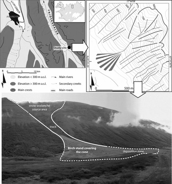
The study was carried out in northern Iceland, in the southern Fnjóskadalur valley, on one of the largest colluvial cones on the eastern side of the valley (65°35ʹ30ʹʹ N, 17°44ʹ17ʹʹ W). The topography is characterised by steep slopes ranging from 200m asl to 820m asl. Talus and colluvial cones form below 350–300m asl (Fig. 1). The cone itself, exposed southwestwards, exhibits a downy birch tree and shrub cover (Betula pubescens Ehrh.), as previously described in Decaulne and others (Reference Decaulne, Eggertsson and Sæmundsson2012) (Fig. 1), while the valley bottom is covered with an arctic heath, heavily grazed, mainly by sheep. In the Fnjóskadalur area, only a few snow-avalanche events have been reported as the area is remote from human activities. However, the valley is well known to be dangerous during snowy days due to its avalanche reputation, and the winters 1994–1995, 1995–1996, 2000–2001 and 2008–2009 were specifically reported to have avalanches in this area (Icelandic Meteorological Office, personal communication, 2010). In this valley, several avalanche paths were clearly identified in the field by the abundance of scattered boulders in the runout zone and the presence of severely tilted trees. The cone investigated here has a concave profile, clearly marked by snow-avalanche activity (Decaulne and Sæmundsson Reference Decaulne and Sæmundsson2010): debris distribution reveals longitudinal sorting with coarser material located mainly at the most distal part of the profile and the orientation of boulders attests a strong correlation with the direction of the cone main axis. The basal accumulation of rocks (up to 250cm in a-axis) is diffuse and lies over 2° to 1° slopes of grass and low shrubs, clearly marking out preferential deposition areas. The accumulation, exclusively built by snow-avalanche recurrence, extends 350m beyond the edge of the cone.
Location of the study area (Photo: A. Decaulne).

Mean temperature at the closest weather station (Akureyri, 17km northwestwards, at sea level) is +3.2°C, the coldest month being only −2.2°C on average; average total precipitation is 489mm.yr−1, but snow never represents the full precipitation amount, even during the coldest months. In the valley, avalanche weather typically gathers strong northerly to easterly winds with heavy snowfall (Haraldsdóttir and others Reference Haraldsdóttir, Tracy, Jensen and Ólafsson2006), associated with sensitive orographic enhancement and strong gradients of snow amounts leading to local extremes of snow accumulation over more or less short periods of time (Brynjólfsson and Ólafsson Reference Brynjólfsson and Ólafsson2009).
Methods
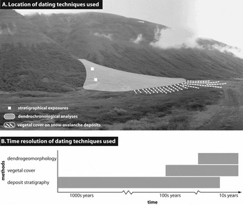
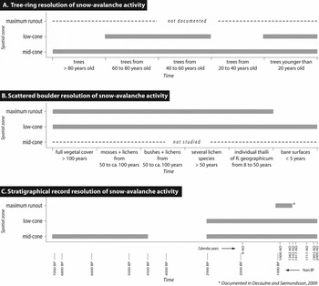
This study combines several methods, focussing spatially on the lower parts of the snow-avalanche path (that is, the lower track and the depositional zone), to characterise (i) the occurrence of snow avalanches through time, and (ii) the maximum reach of the most extreme snow avalanches (Fig. 2a).
Spatial distribution of dating techniques used (A) and time resolution of dating techniques (B).

The dating of the snow-avalanche events is suggested by using dendrogeomorphology, vegetation cover and stratigraphic records. The chronological context in which snow-avalanche activity occurs is therefore analysed at three timescales (Fig. 2b): (i) short timescale (10 years to dozens of years), (ii) mid timescale (secular to pluri-secular), and (iii) long timescale (pluri-millenial).
Dendrogeomorphology is applied within the forested part of the investigated snow-avalanche path. Dendrogeomorphological evidence examines both external evidence of snow-avalanche activity (the visible deformation and shape of trunks) and internal evidence based on analysis of tree rings (for example, Alestalo Reference Alestalo1971; Schweingruber Reference Schweingruber1996; Szymczak and others Reference Szymczak, Bollschweiler, Stoffel and Dikau2010). Dendrogeomorphology applied to snow-avalanche studies of birch examines: (i) tension wood occurrence (structural response of the tree to being tilted on the upslope face of the trunk) identified from cross-sections of the trees or tree cores; (ii) significant eccentricity of growth; (iii) death of trees sheared or damaged by avalanches; and (iv) wound events (see, for example, Germain and others Reference Germain, Hétu, Filion, Stoffel, Bollshweiler, Butler and Luckman2010; Luckman Reference Luckman, Stoffel, Bollshweiler, Butler and Luckman2010; Speer Reference Speer2010) produced by debris transported within the avalanche (snow, rock and/or vegetal debris). Most often, evidence from tree rings is used to date the external damage, easily visible on the trunk.
Dendrogeomorphology therefore extracts a yearly record of snow-avalanche activity. This study focuses on tilted trunks, significant eccentricity of growth (only the first year of tension wood formation is taken into account) and death date, involving 39 trees.
Vegetation cover on 68 boulders deposited by snow avalanches in the distal deposition zone provides information on the time elapsed since their deposition, inferring the relative age of the snow avalanches that deposited these boulders. Six stages were identified. The most recent stage includes boulders with bare surfaces (no vegetation is present on the boulder) and the earliest one includes boulders fully covered (the boulder is buried under vegetation, grass and/or shrubs). Intermediate chronological stages are distinct: only Rhizocarpon geographicum thalli are visible; presence of several lichen species; partly covered by neighbouring bushes; and presence of mosses on the rock surface (Decaulne and Sæmundsson Reference Decaulne and Sæmundsson2010). This simple method discriminates the diachronic deposits and gives information about the snow-avalanche magnitude variability through time.
Stratigraphic records are investigated through natural exposures within the snow-avalanche path. The succession of colluvial accumulations was interpreted in terms of potential slope dynamics, according to the thickness of the layers, the size of the material, the structure of sediments and the organisation of debris within each unit, following Blikra and Nemec (Reference Blikra and Nemec1998). Dating of the stratigraphic records is carried out using tephrochronology, taking advantage of the known tephrochronological record in the volcanic Icelandic environment. Geochemical analyses have been carried out to identify the volcanic eruption responsible for the ash fallout (Jakobsson Reference Jakobsson1979).
By combining these dating methods, one highlights either the runout or the lower track zone, in addition to documenting different timescales.
Imbrications of timescales in snow-avalanche activity research
Short-timescale evidence of snow-avalanche activity
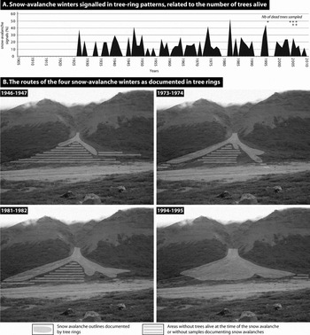
During the last few decades, the downy birch stand that covers the cone which is part of the investigated path has been repeatedly stressed by numerous snow avalanches, some crossing the whole stand and spreading over the pseudo-flat bottom of the valley, and some stopping within the stand. Examination of the path revealed: (i) extensive damage to trees in the upper parts of the cone where snow-avalanche activity is expected to be more frequent; (ii) trees tilted downslope on the cones, showing the recurrent stresses they had faced; (iii) clear eccentricity in tree growth, with the upslope side producing much more wood than the downslope radius; this is a common feature of the 39 trees that were sampled in this path (Decaulne and others Reference Decaulne, Eggertsson and Sæmundsson2012). The dendrogeomorphological results supplement satisfactorily the poor historical records of snow avalanches in the area (only four winters being formally reported as avalanche-rich at the valley scale, not even at this precise location), by identifying 52 winters in which snow avalanche(s) affected the stand, either partly or totally (Fig. 3a). Among those 52 winters, four are regarded as major, as they are signalled in the tree-ring patterns (strong increase in the ring growth on the strained face of the trunk, associated with a clear decrease of ring growth on the opposite side) of more than 40% of the sampled trees alive (from 12 to 38 trees sampled) on the cone at this time. Those winters are 1946–1947, 1973–1974, 1981–1982 and 1994–1995 (Decaulne and others Reference Decaulne, Eggertsson and Sæmundsson2012). One more year, 1926–1927, appears but is signalled in only half of the eight trees alive at this time, the number of old trees being limited on the cone. Two of the four winters that were reported for the number of avalanches they triggered within the valley (1994–1995, 1995–1996, 2000–2001 and 2007–2008) are clearly identified within the tree-ring records (1994–1995 and 2000–2001). The signals of the winters 1995–1996 and 2007–2008 are weak, even if a long-tension wood event appears, which may mask the occurrence of additional events in subsequent years; then, either the sign of avalanches during winter 1995–1996 is diluted in the tree rings because of the previous winters when the trees faced strong snow-avalanche stress, or snow avalanches reported during those winters did not affect the cone.
Identification of the 52 winters with attested snow avalanches through tree-ring analyses (A); and spatial representation of the routes of the snow avalanches during the main active winters (B).

Dendrogeomorphology is able to decipher the preferred routes of the snow avalanches on the lower cone during these few winters according to the position of trees signalling snow avalanche (Fig. 3b). However, the spatial extent of the snow avalanches over the cone, within the lower track and the distal runout zone, is limited to clear tree-ring documentation, as the results are restricted to the tree-cover part of the path. The absence of trees might anyway be interpreted as the preferred path of snow avalanches, the recurrence of the process, associated with debris transfer, being a strong impediment to tree development within the main track and runout zone. Therefore, even if return periods are calculated and might be mapped (Decaulne and others Reference Decaulne, Eggertsson and Sæmundsson2012), the maximum runout distance of the potentially most severe snow avalanches, those with low return period and large magnitude that overpass the cone, cannot be highlighted using dendrogeomorphology at this specific site. Scattered boulders in the depositional zone, however, are able to deliver answers regarding the furthest reach of snow avalanches.
Short to mid-timescale evidence of snow-avalanche activity
Scattered coarse and angular boulders located at the toe of the slope were evidence of the main visible geomorphological work of snow avalanches in Iceland (Decaulne and Sæmundsson Reference Decaulne and Sæmundsson2006b). In the Fnjóskadalur site discussed here, the diffuse accumulation in the distal zone shows poor sorting and a large amount of debris, confirming observations made by previous researchers (Luckman Reference Luckman1978; Jomelli Reference Jomelli1999; McEwen and others Reference McEwen, Owen, Matthews and Hiemstra2011), although such deposits in the distal downslope, on sub-flat areas, are poorly described in the literature. Systematic measures on all 68 boulders over 60cm in a-axis (size ranging from 60cm to 250cm, with the majority in the range from 80cm to 160cm) show a preferred orientation parallel to the cone main axis (Decaulne and Sæmundsson Reference Decaulne and Sæmundsson2010), which is thought to be strong evidence of snow-avalanche origin. The strict parallel orientation is occasionally altered by ground topography after melting, and by the snow-avalanche dynamic while reaching flat areas, developing distinct lobes due to multiple sliding planes (Mears Reference Mears1980; Bertran and Jomelli Reference Bertran, Jomelli and Bertran2004). In addition to the angular and subangular clasts, and to the scatter of clasts, which has clear boundaries, the very location of these boulder accumulations excludes all other possible transport processes, even if snow avalanches have redeposited material reworked from other landforms (Ward Reference Ward1985). Therefore, the snow-avalanche origin of the rock deposit is suggested by the tendency for parallel orientation.
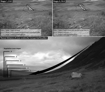
The vegetation cover on all 68 boulders was surveyed: 4.1% present bare surfaces; 8.2% have a lichen cover of Rhizocarpon geographicum only; 38.5% have several lichen species; 8.2% are partly covered by neighbouring bushes; 24.5% present mosses on the rock surface; and 16.5% are fully covered with vegetation. These six stages of vegetation cover on the rock surface indicate the relative age of the depositions (Fig. 4). Estimating this age is feasible for some stages, even approaching absolute dating, but trickier for others. It is estimated that bare rocks were deposited within the last five to ten years, as deduced from the time needed by Rhizocarpon geographicum to be visible on the rock surfaces. This time-period estimate is based on previous studies carried out in the Icelandic Westfjords (Decaulne and Sæmundsson Reference Decaulne, Sæmundsson, Rickenman and Chen2003), at locations from 25m to 100m asl, which emphasised that lichen thalli are not visible on the surface of rocks that settled less than eight years ago; and in northern Iceland, where Kugelmann (Reference Kugelmann, Maizel and Caseldine1991) built a lichen-growth curve that defines a time span for lichen colonisation of about five years. Boulders showing individual thalli of Rhizocarpon geographicum are aged from about eight years (thalli of only a few millimetres in diameter) to about 50 years old (thalli diameter over 15–20mm), according to the existing lichen-growth curves (Kugelmann Reference Kugelmann, Maizel and Caseldine1991; Decaulne and Sæmundsson Reference Decaulne, Sæmundsson, Rickenman and Chen2003; Decaulne and others Reference Decaulne, Sæmundsson and Pétrusson2005). The age of stage 3 deposits is estimated to be over 50 years old, and the age of stage 6 deposits is estimated to be over 100 years old (Decaulne and Sæmundsson Reference Decaulne and Sæmundsson2010), depending on their size (smaller boulders are covered faster; huge boulders are never covered, but the necrosis of lichens and mosses, the weathering of the boulder surface, indicates their great age). While boulders partly covered with bushes and boulders partly covered with mosses are easily distinguished in the field, their age is more difficult to decipher, as both forms of vegetation cover are highly dependant on local conditions (size and shape of the boulder, local topography, humidity and other factors). However, when the boulder deposits within the runout zone are mapped, age distributions show the magnitude and temporal trends of snow avalanches with geomorphological impact within the lower flat runout zone (Fig. 4); even all stages of vegetation development on mineral surfaces are mixed. Boulder accumulations presenting bare surfaces are spatially very limited, indicating a rather restricted dispersion of the most recent snow-avalanche events transporting boulders. In comparison, accumulations of boulders belonging to stages 6 and 3 are much wider. This indicates two major periods of active erosion and associated deposition by snow avalanches: one that ended around 1950 (stage 3), and another one that ended around 1900 (stage 6); this last one reached even longer runout distances. It also corresponds to the mid-twentieth century records of a return of snow avalanches that caused material damage but no severe injury to people, in the 1940s and 1950s (Decaulne Reference Decaulne2005), and the post-Little Ice Age period of increased snow-avalanche activity that has been previously identified in the Alps (Jomelli Reference Jomelli1999). Stages 2, 4 and 5 are more limited spatially, but nevertheless reach longer runout distances than the most recent snow avalanches, indicating a clear waning of the capability of snow avalanches to deposit large boulders at long distances in the last decades.
Spatial distribution of snow-avalanche transported boulders in the distal runout zone, discriminated by vegetal coverage to propose the relative age of the deposits from oldest (stage 6) to youngest (stage 1) boulders.

Long-timescale evidence of snow-avalanche activity
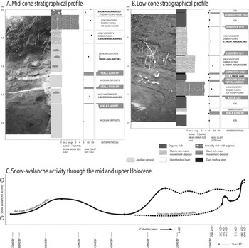
Stratigraphic profiles are valuable, as they highlight snow-avalanche activity on long timescales. Within the profiles, ‘one clast thick overall scatter of debris’ (Blikra and Nemec Reference Blikra and Nemec1998) marks the avalanche deposit, as it does on the surface for present-day activity. In natural exposures along the snow-avalanche path (Fig. 5), unsorted scattered clasts, coarse and angular, are observed, embedded within much finer material rich in organic matter. Fig. 5 shows two stratigraphic profiles from the investigated colluvial cone, where scattered rock debris (>20cm in long axis) within the deposit is associated with former snow-avalanche activity that seemed to be a relevant dynamic on slopes at different periods according to tephrochronologic dating that time-marks the slope dynamic sequences. This makes it possible to track snow-avalanche activity through the mid and upper Holocene period. According to the position of the stratigraphic profile on the cone, the record of past snow-avalanche activity differs temporally and spatially (Fig. 5c). On the mid-cone profile, the period previous to 6900 bp seems to have been rather unfavourable to snow-avalanche activity, as no evidence is observed. The contrary is true between 6900 bp and 4500 bp, in which isolated boulders are clearly visible within aeolian deposits; snow avalanches are then evidenced with scattered boulders after 2900 bp up to the present, sometimes undistinguishable from open-work debris-flow deposits. Boulders scattered over the present-day surface of the cone, with the well known, typically numerous perched boulders, attest the activity of snow avalanches during recent years and decades. The lower stratigraphic profile exposes fewer large boulders, but indicates snow-avalanche deposits before and after 1332 ad, and after 1417 ad; also, the scattered boulders at the surface of the cone show the present-day snow-avalanche activity.
Stratigraphic profiles from the cone, showing evidence of snow-avalanche activity that contributed to the cone. The tephra layers that provide dating in the sequences are shaded in grey. A: mid-cone stratigraphic profile; B: low-cone stratigraphic profile; C: snow-avalanche activity through the Holocene.

Discussion and conclusions
In this study area, clear evidence indicates the recurrence of snow-avalanche activity, from the source area to the distal runout zone; that is, the morphology of the rock wall, the concave profile of the colluvial cone, the abundance of scattered boulders far within the sub-flat area and the deformed shape of the trees on the cone. Most of the previous work dealing with geomorphological impact of snow avalanches concentrates on the cone (for example, Luckman Reference Luckman1978; Jomelli Reference Jomelli1999; Bertran and Jomelli 2000), omitting the distal runout zone, perhaps because this zone is often poorly developed in mountain areas due to local topography. In addition, stratigraphic profiles are seldom used in avalanche research. Dendrogeomorphology is increasingly used to date active winters (see, for example, Corona and others Reference Corona, Rovéra, Lopez Saez, Stoffel and Perfettini2010; Germain and others Reference Germain, Hétu, Filion, Stoffel, Bollshweiler, Butler and Luckman2010; Szymczak and others Reference Szymczak, Bollschweiler, Stoffel and Dikau2010; Corona and others Reference Corona, Lopez Saez, Stoffel, Bonnefoy, Richard, Astrade and Berger2012), and the technique has proved successful.
However, the accuracy of the results obtained at different scales of time and space based on natural investigation should be discussed (Fig. 6). Dendrogeomorphology can deliver a chronology of snow-avalanche events in the investigated paths that could be extended to a regional scale when snow-avalanche events are known from given years. From this step, frequency and magnitude can be derived. However, the results are limited by the age of the stand and species investigated: for example, young birches are very flexible with tilting, branch trimming, or ring-width releases due to loss of neighbouring trees, which may be caused by other natural processes acting on slopes, such as rock-fall or debris flows. These processes are active in Iceland even during winter and it is necessary to be very aware of the local geomorphological setting when sampling trees in the upper cones. The method also fails to provide information on the number of snow avalanches in a single winter as it cannot discriminate between the effects of one or several events in the same winter. Furthermore, the pressure of the snow avalanche passing the tree or the pressure of the snow-avalanche deposit resting on the tree may result in tilting. Neighbouring trees may react differently to the same event: in some the stress will cause a decrease in tree-ring growth, whereas in others it will provoke a tree-ring release. The duration of the release varies between one and several growing seasons; therefore, long-tension wood formation may mask the occurrence of additional events in subsequent years. In Iceland, the lack of trees in the distal runout zone of the snow avalanches does not offer records of extreme events. Therefore, tree rings are not fully reliable to decipher snow-avalanche winters; Corona and others (Reference Corona, Lopez Saez, Stoffel, Bonnefoy, Richard, Astrade and Berger2012) estimate at about 43% the number of events recorded by snow avalanches in a well documented area from historical sources in the Alps. In places lacking complete historical records, dendrogeomorphology remains an appreciated alternative.
Synthesis of the spatial and temporal contribution of each method, also highlighting their respective limits.

Scattered boulders deposited in the distal part of the snow-avalanche paths can be used at sites where snow avalanches contain rock debris and can therefore provide a minimum extent of the maximum runout distance of snow avalanches. However, relatively clean avalanches may extend beyond the zone of rock deposition. Different types of avalanches have different geomorphological impacts, and the time and period of occurrence are very important (Keylock Reference Keylock1997): focussing on snow avalanches that transport debris does not encompass all snow avalanches. The vegetal cover on the boulders provides relative ages that are more accurate than the estimates provided from stratigraphic evidence. However, stratigraphical data can provide evidence of snow-avalanche magnitudes over the last 100 years. These results may be used to develop simple topographic models that can be used for inhabited communities at similar sites. As Decaulne and Sæmundsson (Reference Decaulne, Sæmundsson and Brebbia2006a, Reference Decaulne, Sæmundsson, Schaefer, Schuster and Turner2007) and Decaulne and others (Reference Decaulne, Sæmundsson, Jónsson, Jónsson and Jóhannesson2008) illustrated, large areas of the coastal villages of northwestern Iceland are at risk, as most of the built-up areas might be located within the runout zone of snow avalanches, even on cones, which are often the only sites available for settlements. Models built on geomorphological evidence from adjacent sites could be used to assess whether some of the major events reported recently are among the largest that might be expected, while other areas have not yet released the major potential events.
Stratigraphical analyses provide quite a good spatial distribution of the extent of past snow-avalanche events over very long periods. However, due to the location of the profiles on the colluvial cones, reachable by other dynamics than avalanches, isolated boulders might have some rock-fall origin; also, identifying the contribution of snow avalanches to the edification of debris flow levees is very difficult on such a timescale. Therefore, the stratigraphic analysis of cone-deposit sequences is interpretative. The dating of the events is rough, and depends on tephrochronological or radiocarbon dating. Age estimates either pre-date or post-date the snow-avalanche deposits and, based on tephra date, are between 85 and over 2,300 years old. The method is unsatisfactory for dating recent snow-avalanche events, but identifies areas that have encountered snow-avalanche activity in the past.
Separately, each of these methods has limitations as a tool to map the extent of snow avalanches and to date the most dangerous events (Fig. 6). Combining these methods may offer a significant improvement over the results of any single technique. They enhance significantly our knowledge of the recurrence of snow avalanches, and improve our understanding of natural hazards and suitable defences.
This article proposes that an overview of geomorphological, dendrochronological and stratigraphical evidence can be used to analyse the extent of former snow-avalanche events and thereby contribute to mitigation of the risk for communities, by transferring the results there (Decaulne and others Reference Decaulne, Sæmundsson, Jónsson, Jónsson and Jóhannesson2008). The Icelandic case study clearly demonstrates that several forms of geomorphological and tree-ring evidence are worthwhile from this perspective. In addition, knowing that severe snow-avalanche winters are quite common in Iceland, at least at a regional scale, and may occur on several slopes in the same winter (see, for example, Jóhannesson and Jónsson Reference Jóhannesson and Jónsson1996; Vedurstofa Íslands 2005), the knowledge acquired for one area might be useful in others.
Acknowledgements
Financial support for this study was received from the French Arctic Research Group CNRSGDR3062 at Besançon, France. Technical facilities were received from the Natural Research Centre of Northwest Iceland, Saudárkrókur, Iceland, and from the Icelandic Forest Service, Research Branch, Mogilsá-Reykjavík.