

The Kingdom of Dahomey emerged on the Slave Coast of West Africa in the second quarter of the seventeenth century. Following nearly a century of Fon expansion across the Abomey Plateau, King Agaja (1708–40) conquered his southern neighbors, the kingdoms of Allada and Hueda. Over the course of the eighteenth century, subsequent Dahomean kings solidified control over their conquests in the face of multiple contests for power within Dahomey, as well as constant threats from the Yoruba Kingdom of Oyo. Dahomey continued to expand despite a potentially destabilizing shift from slave trade to ‘legitimate’ commerce in agricultural products in the mid nineteenth century. Thus Dahomey rose and flourished just as many of its contemporaries weakened and collapsed.Footnote 2
How Dahomey achieved order in this period of dramatic political and economic instability has been the focus of historical research since the eighteenth century. Contemporary scholarship has examined whether Dahomean government institutions represented a dramatic ‘revolution’, or rather reflected general ‘continuity’ in political order on the Slave Coast.Footnote 3 To date this discussion has been based upon period documents and more recent oral traditions. Archaeology can contribute to this discussion, and research in southern Bénin is beginning to do just that. Archaeological research in the region has focused largely on the royal palace sites of Allada and Hueda.Footnote 4 Such sites were important centers in the political, ritual and economic life of kingdoms on the Slave Coast and thus present ideal contexts in which to explore the nature of political order archaeologically.
Initiated in the year 2000, the Abomey Plateau Archaeological Project integrates documentary, oral and archaeological evidence to address the nature of Dahomean political order over time.Footnote 5 Specifically, this research explores the regional distribution and internal layout of royal palace sites identified across the Abomey Plateau in light of anthropological models of political and economic organization. Construction programs identified at the regional level indicate that Dahomey significantly expanded state control throughout its territories over the course of the eighteenth and nineteenth centuries as a response to changing opportunities presented by both the Atlantic trade and internal economic growth. Transformations in the layout of palace sites highlight the evolving nature of Dahomean government and the strategies employed by its kings to foster stable political control. These data suggest that, although Dahomey shared a number of important qualities with its predecessors, it responded flexibly to the challenges presented by Atlantic commerce, achieving real administrative advances in the eighteenth and nineteenth centuries. An example of neither political ‘continuity’ nor ‘revolution’ exclusively, Dahomean government represents dramatic ‘evolution’ in the nature of political order on the Slave Coast of West Africa.
THE PROBLEM OF POLITICAL ORDER ON THE SLAVE COAST
Drawing from seventeenth- through nineteenth-century travelogues, correspondences and more recently collected oral traditions, modern scholarship has attempted to account for the nature of political organization on the western Slave Coast.Footnote 6 Scholars once argued that the three major kingdoms of the region, Allada, Hueda and Dahomey, were ideologically united by the belief in divine kingship and the practice of royal ancestor worship.Footnote 7 Dahomey was thus seen as ‘a development and extension of an institution already widespread amongst a people of similar culture’.Footnote 8 The lion's share of contemporary research, however, has emphasized how Dahomey differed from its predecessors. A detailed discussion of this recent historiography is unwarranted here, yet a number of common trends can be identified in the writings of select authors.Footnote 9
In 1967, for example, Isaac Adeagbo Akinjogbin published a compelling argument for dramatic political transformation on the Slave Coast.Footnote 10 Akinjogbin argued that, prior to the eighteenth century, polities in this region were made up of federations of autonomous lineages united under a hereditary ruler who served essentially ritual functions.Footnote 11 He suggested that it was precisely the loosely centralized nature of these kingdoms that led to their demise and the emergence of Dahomey as the major power in the region.Footnote 12 Dahomey developed a revolutionary political system in which power was based on centralized military might rather than traditional rules of royal descent. Military power allowed Dahomey to construct a centralized bureaucratic apparatus that broke radically with the kin-based institutions of the past, and was thus better able to resist collapse.Footnote 13
To varying degrees this argument was met with heavy criticism in subsequent publications. David Ross, for example, drew attention to the problematic use of source material by Akinjogbin, who often ignored contradictory evidence within the sources he cited.Footnote 14 Ross argued instead that existing source material paints Dahomey as essentially ‘an Abomey-based “banditti”’.Footnote 15 Ross thus echoed the sentiments of various eighteenth-century authors who emphasized the central role of a military ethos in Dahomean political strategies.Footnote 16 In turn, however, Robin Law questioned altogether the ‘revolutionary’ qualities of Dahomean government, drawing attention to important continuities between Dahomey and its predecessors.Footnote 17 These included elements of royal ideology that Dahomey shared with Allada, as well as similarities between the administrative structures of Allada, Hueda and Dahomey.Footnote 18 Although Law suggested that the manner in which power was symbolically legitimized and structurally organized was similar in these kingdoms, he agreed, however, that centralized military authority was, in fact, the defining characteristic of Dahomean statecraft. Except in the military sphere, therefore, Dahomean administration differed from its predecessors only in degree rather than in its overall quality.Footnote 19
Scholarly concern about the role played by militarism in fostering political order in Dahomey can be linked, arguably, to the nature of the sources commonly cited to reconstruct the history of this West African kingdom. European visitors to Dahomey were rarely given leave to roam freely, and were normally permitted to visit the capital only during the annual state-ceremonial cycle. Thus period descriptions tend to draw attention to the more dramatic aspects of Dahomean court life, including public displays of state militarism and human sacrifice. As Robert Norris observed in the eighteenth century, however, because ‘it is criminal in the natives of this country to discourse on politics, or to make any remarks upon the administration of public affairs, it is difficult to acquire any extensive knowledge of facts and the little information which can be obtained, is but imperfect’.Footnote 20 It is likely, therefore, that many of the less conspicuous aspects of Dahomean government went largely undocumented by foreign observers.
Historians have recognized for some time that this fact places certain limits on the interpretive value of written documents for reconstructing precolonial African history, limits that can be balanced by the careful use of oral evidence.Footnote 21 Drawing from extensively collected oral traditions, Edna Bay presented an additional perspective, which complemented, and sometimes contradicted, historical reconstructions of Dahomean political organization based largely upon written sources.Footnote 22 Bay documented the evolution and growth of a state apparatus, which, by the nineteenth century, established expansive palatial control over its territory. Like Law, Bay argued that the dynamics of state-building in Dahomey were strongly influenced by existing political principles. However, she presented compelling evidence that the structure of political relationships within Dahomey was shaped significantly by the need to balance the power of emerging political factions within the kingdom. Militarism was, according to her, a by-product of broader attempts at establishing political stability in the era of the slave trade.Footnote 23
Oral traditions, however, have their own interpretive limits. Royal oral traditions tend to project orthodox histories promulgated by political ‘victors’ and thus are often cast to serve the interests of those in power. Unfixed in time, oral traditions can also change from generation to generation to suit evolving political agendas. Thus although oral traditions are exceedingly valuable as a counter-balance to documentary evidence, reliance on such sources also may result in a skewed perspective on political dynamics in precolonial Africa.
Despite a history of intellectual ‘sibling-rivalry’ between archaeologists and historians in Africa,Footnote 24 the integration of written, oral and archaeological data can contribute valuable new perspectives to our understanding of this period. The challenges faced by Dahomean kings in establishing political order would, in fact, sound quite familiar to archaeologists working in many world regions. Indeed, archaeologists have long wrestled with the question of how stratified societies in which power is based on rules of descent – or what anthropological archaeologists typically refer to as chiefdoms – transform into strong centralized states.Footnote 25 Anthropological and archaeological research has also largely supported the argument that kin-based power structures are particularly fragile and prone to fission or collapse under stress.Footnote 26 It is commonly argued that regular cycles of expansion and collapse can be avoided only if anti-fission mechanisms are implemented that successfully quell internal dissent and minimize the likelihood of segmentation, a point recognized long ago by Africanists of various intellectual pedigrees.Footnote 27
Centralized control over military might is a cross-culturally observed phenomenon in early state formation.Footnote 28 As Bay noted in reference to Dahomey, however, this process was often symptomatic of much broader administrative tactics designed to facilitate long-term stability. Indeed, early states often sought centralized control over most spheres of social interaction, drawing from multiple sources of power.Footnote 29 As the Mesopotamianist Norman Yoffee recently put it, ‘all three main dimensions of power and the different means of achieving power – the struggle for control of economic resources, control of knowledge, ceremonies and symbols, and control of armed forces – need to be co-evolving for states to emerge, since these three sources of power all reinforce one another’.Footnote 30 Thus although the design of early state institutions was quite variable cross-culturally, archaeologists commonly argue that such polities sought centralized control over a broad range of military, ritual and economic sectors.
Political integration in emerging states was fostered by the creation of institutions designed to project authority outwards from political centers, breaking the kin-based power structures of local chiefdoms.Footnote 31 States accomplished this level of control by constructing specialized and centralized apparatuses for direct regional administration.Footnote 32 Ideally, this allowed the efficient flow of information and commands throughout state spheres, permitting effective central management. In practice, however, this often led to bloated and rigid political apparatuses in which positions were granted in exchange for allegiance. This bound the interests of potentially competing factions to those of the king, mitigating the likelihood of political fission. In reality, this process was rarely as smooth as idealized anthropological models suggest. Indeed centralized polities were often riddled with internal conflicts that were constantly negotiated in the process of establishing ‘stable’ political authority.Footnote 33
Historical sources suggest that this was, in fact, the case in Dahomey. Specifically, the available historical evidence suggests significant expansion in two variables in the eighteenth and nineteenth centuries: the level of bureaucratic specialization and the extent of regional control. For example, following the arrival of the Fon in the early seventeenth century, Dahomean expansion across the Abomey Plateau began in earnest, and by the reign of Akaba (1680–1708) the entire plateau was effectively under Dahomean control. Oral traditions referring to this period, however, suggest that Dahomey largely depended upon elites originating from within conquered towns to administer its territories.Footnote 34 Early Dahomean government, therefore, appears to have been weakly centralized and governance was rooted in local lineage-based power.
Following the conquest of Allada and Hueda by King Agaja, the nature of government appears to have changed dramatically in this region. Historical sources unequivocally agree that force was a significant component of early Dahomean strategies for integrating its conquests. Indeed Robert Norris suggests that Agaja initially sought to create order ‘by the expedient of firing the towns, and slaughtering the inhabitants’.Footnote 35 Other sources suggest, however, that subsequent rulers experimented with novel political strategies, including the expansion of bureaucratic control over Dahomean territories.
For example, eighteenth-century sources identify a core group of high ministers, or bonugan daho, who provided support for the expanding state. Under King Gezo, the palace became the residence of additional female officials, or begani, who corresponded to the major male dignitaries and their subordinates. In all, these officers, male and female, were state-appointed officials, charged with directly administering various political, economic, military and religious sectors of the kingdom. Additionally, whereas eighteenth-century sources are relatively silent on the nature of regional governance, by the nineteenth century, towns throughout Dahomey were clearly managed by officials sent from Abomey. Indeed, major centers like Whydah and Allada, as well as minor towns such as Whegbo, were divided into quarters, each of which was controlled by lower-ranking officialsFootnote 36 ‘who regulate their own departments, and distribute justice except in some extraordinary cases which are referred to Abomey’.Footnote 37
In the years following Agaja's conquests, therefore, the emergence of an increasingly complex administrative apparatus is hinted at by historical sources, and, by the mid nineteenth century, sources clearly indicate the presence of centralized bureaucracy with extensive regional control. The relative lack of eighteenth-century documentary references to administrative organization, however, makes it unclear how different this system was from those of Allada and Hueda, and how much it changed over time. Indeed, it is possible that our perspective is skewed by the abundance of descriptions of Dahomey's infrastructure dating to the nineteenth century. Archaeology can provide a material perspective to corroborate, qualify or reject the hypothetical reconstruction presented above. The fallen remains of palace complexes are examined below to address the nature of Dahomean regional administration and bureaucratic integration over time.
BUILDING REGIONAL INTEGRATION
Archaeologists have long recognized a relationship between regional settlement patterns and political organization.Footnote 38 The relative size and regional distribution of settlements is strongly influenced by the nature of political and economic organization.Footnote 39 Additionally, expanding political power is often reflected archaeologically by the presence of state facilities (palaces, garrisons, check-points, etc.) at key resources, along major trade routes or near markets.Footnote 40 Such facilities allow governments to efficiently move goods collected as tribute, to garrison troops and to administer activities at a distance from the capital. Understanding the distribution of such facilities across the landscape, therefore, allows broad interpretations about the nature of political order to be made.
In Dahomey, political life was centered around a series of royal palaces that were charged with symbolic references to royal authority.Footnote 41 Oral traditions indicate that Wegbaja (1650–80) built the first Fon royal residence in Abomey over the entrails of a conquered Guedevi chief named Dan. Often-cited modern accounts claim that it is from this event that the kingdom purportedly earned its name Dan-xo-me, or ‘in the belly of Dan’ (xo – stomach, me – in).Footnote 42 In later years, the Abomey palaces were the venue for the Annual Customs or Xwetanu, during which wealth was distributed to the masses and human captives were sacrificed to the royal ancestor cult. Blood from human sacrifices was mixed with the earth used to build the palace walls. They were decorated with bas-reliefs depicting symbols of state power, and were often lined with the heads of enemies slain in battle.Footnote 43
In addition to these salient reminders of royal power, however, palaces served more mundane administrative roles in Dahomey. These structures served as the primary residences of the king and his dependants, who may have numbered from 2,000 to 8,000 at Abomey alone.Footnote 44 Indeed as Le Herissé states, ‘the palace formed a true city within Abomey’.Footnote 45 Many of the royal wives, officials themselves, were placed in palaces throughout Dahomey to manage the interests of the monarchy. Agaja may have built nine palaces during his reign,Footnote 46 and references to additional palaces at Allada, Cana and other towns are common in eighteenth- and nineteenth-century sources. The presence of these structures across the landscape clearly facilitated political integration in Dahomey.
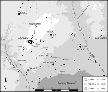
Understanding where Dahomean palace construction was focused would thus shed much light on the question of interest here. The combined use of documentary sources, Beninese informants, aerial photographs and on-the-ground survey located 25 precolonial palace sites across the Abomey Plateau (Fig. 1). These structures ranged in size from approximately 1 to 34 hectares. Oral traditions, limited documentary references and artefacts collected both on the surface and in test excavations allowed these palace sites to be dated to within a particular century, and quite often to the reign of a particular king. Observed changes in the pattern of palace construction suggest broad transformation in the nature of Dahomean regional political order in response to the changing dynamics of Atlantic commerce.
Historically documented settlements (black) and royal palaces (white) identified by the Abomey Plateau Archaeological Project.

The pattern of royal palace construction across the landscape in the seventeenth century supports the argument that regional control was relatively indirect in this period. The first palace constructed by Fon kings was that of Dakodonu (1625–50) at Houawe, the launching point for subsequent expansion across the plateau. Royal palace construction for all subsequent kings of the seventeenth century, however, was limited to Abomey. This supports the argument that, like Allada and Hueda, administrative control in Dahomey was largely limited to the capital at this time. The pattern of royal palace construction changed dramatically over the course of the eighteenth and nineteenth centuries, however.
Following Agaja's conquests, large complexes were increasingly constructed at a distance from Abomey suggesting an elevated level of regional control in this period. Indeed, eighteenth-century palace construction was focused along the road through Cana to Agrimey, the dominant trade route to the coast.Footnote 47 Control over the rest of the plateau in this period, however, appears not to have been a priority. This suggests that royal control over those areas off the major north–south trading axis may have remained relatively indirect at this time, and reflects Dahomey's primary concern for centralizing control over the main artery to the coast.
In contrast, palaces constructed by Kings Gezo, Glele (1858–89) and Behanzin (1889–93) are located largely in areas to the north, east and west of this main road, indicating that centralized control expanded to areas off the major north–south trade axis in the nineteenth century.Footnote 48 A number of factors may explain this observed shift in the direction of palace construction. The roads from Abomey and Cana to Zagnanado provided access to eastern Yoruba kingdoms, constant military concerns for Gezo and Glele. Palace construction, therefore, would have facilitated military action in this direction. However, this pattern may also reflect a general concern with both facilitating and profiting from various economic activities across the region in the nineteenth century.
Indeed palace construction along these roads would also have facilitated royal control over trade with these eastern Yoruba kingdoms. Archaeological evidence supports the notion that the construction of palaces to the east of Abomey was contemporary to growing economic interaction with the Yoruba world. Polished black ceramics, most commonly bowls decorated with horizontal incisions, are common in excavated palace contexts at Cana dating to the nineteenth century. These ceramics strongly resemble pottery that appears across the periphery of the Oyo Empire by the eighteenth century.Footnote 49 At present it is not known whether these were produced locally or imported from Yoruba territories. The importing of ‘Yoruba-style’ ceramics in the nineteenth century would indicate Fon–Yoruba trade, despite ongoing military conflict in this period. If produced within the kingdom, however, these ceramics might indicate the growing presence of Yoruba artisans in Dahomey following the collapse of the Oyo Empire.Footnote 50 Ongoing ceramic analysis attempts to resolve this issue.
Palaces constructed in Abomey's countryside would also have facilitated the state's growing interest in managing local production in this period as well. Indeed historical sources suggest that numerous officials in the nineteenth century were charged with agricultural zoning, parceling out land to farmers and keeping track of the limits of local land holdings. This development was contemporary with the decline in royal revenue from the slave trade, and the increasing importance of palm products to the national economy.Footnote 51 Palaces built to the southwest and east of Abomey are located in what are today considered the most agriculturally productive regions of the plateau, and both documentary and oral sources suggest that a number of royal palaces were used to centrally manage palm oil production. Skertchly, for example, documented a palace on the Cana road devoted to the production of this commodity.Footnote 52 Da Amousou Folly, King of Agbanhizoun, also proposed that this was the explicit function of a palace built by Gezo in his town.Footnote 53 Other goods were produced in these complexes as well. Documentary sources indicate, for example, that the production of millet beer (pitto), ceramic vessels, cowry beads, cloth and clay tobacco pipes was monopolized by the royal palace.Footnote 54 Limited archaeological excavation has identified evidence for the production of shell beads and palm oil within the palace of Kings Gezo and Glele at Cana-Gbengamey, as well as a well-developed tradition of ceramic production.Footnote 55
Spatial analysis of this nineteenth-century regional pattern appears to reflect regional market-spacing norms as well, suggesting that the state sought to profit from an expanding domestic economy in this period.Footnote 56 Archaeologists have a number of powerful analytical techniques for interpreting how sites functioned within a region. These generally involve identifying the relative area of influence around sites distributed across a landscape, and linking observed patterns to ethnographic examples with known causes. In Bénin today, as in other areas of West Africa, the major weekly markets, held every four days, tend to be spaced approximately 10 kilometers from one another, servicing an area with a radius of approximately 5 kilometers, or a single day's walk to and from.Footnote 57 Larger towns with royal palaces on the Abomey Plateau are spaced an average of 10·75 kilometers from one another. Additionally, oral sources suggested the presence of large markets at or near many of these sites in the precolonial period.
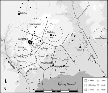
Drawing Thiessen polygons around archaeological sites, a method derived from locational geography and central-place theory, clarifies the relationship between these palace sites and regional markets.Footnote 58 Thiessen polygons are composed of lines drawn perpendicular to the mid-points between adjacent sites. Connecting these lines yields a pattern of polygons that predicts the area of influence for individual sites within a constellation of similar sites. Thiessen polygons drawn around palace sites, or clusters of palaces, within towns on the Abomey Plateau are represented in Fig. 2. Rings of a 10-kilometer diameter drawn around such towns match up quite well with these polygons, suggesting a strong correspondence between regions of palace influence and the market-spacing norms described above.
Thiessen polygons and 10-kilometer-diameter service areas drawn around Dahomean palaces, or clusters of palaces, across the Abomey Plateau.

The historical record illuminates exactly how the expanding state profited from these local markets. Historical sources mention the presence of multiple Dahomean officers charged with monitoring the state's trading interests in the precolonial period. At Whydah, for example, officials called akhisino, described as the ‘merchant princes’ of Dahomey, were responsible for overseeing and collecting duties on trade there.Footnote 59 It is doubtless that similar officials were devoted to collecting taxes on goods exchanged through local or long-distance networks elsewhere in the kingdom as well.Footnote 60 According to Duncan, this was facilitated by the placement of customs houses on the major roads leading into the kingdom.Footnote 61 Palace sites may have served, therefore, as higher-order collection points for goods produced and taxes collected throughout the region in the nineteenth century. Future excavation at these sites will illuminate their specific roles within the regional economic system. The data presented above, however, strongly support the argument that market spacing was a major factor in determining palace placement in the nineteenth century, and would have facilitated Dahomey's ability to profit from a growing domestic economy in this period.
These structures, therefore, facilitated the expansion of the Dahomean political economy and dynastic regional control over the course of the eighteenth and nineteenth centuries. Additionally, however, these structures would have made powerful symbolic statements about royal power and authority. The role played by the Abomey palaces in underwriting elite claims to authority during the Xwetanu is clear from the description of these ceremonies presented above. Historical sources indicate that additional Annual Customs were performed at Cana as well, presenting the possibility that public rituals were performed at other palace sites in the region. This would have contributed to legitimating dynastic authority at the local level.
In addition to the possible ceremonial functions of these structures, however, palaces would have been constant reminders of the presence and the power of the state. In our own contemporary societies, we are often unfamiliar with the labor costs of the buildings in which we live and work. In contrast, it is said that each ‘Dahomean man must know three things well: how to cut out a field, how to build a wall, and how to roof a house’.Footnote 62 With such intimate familiarity with the construction process, non-elite members of the communities living near these structures doubtlessly would have been impressed with the level of investment in these statements of royal authority. In addition to the economic functions described above, therefore, Dahomean construction campaigns across the countryside served the equally valuable role of symbolically materializing elite authority at the local level.Footnote 63
The kings of Dahomey, therefore, strategically built royal palaces across the countryside to expand state control over key economic sectors and to symbolically project the power of the ruling dynasty. The rate of palace construction over time was, however, inconsistent. Palaces were constructed by a combination of labor sources. Slaves of the king, as well as those of various officials, were often put to the task of building or renovating the king's palace walls annually.Footnote 64 It is likely that local labor collectives, or dokpwe, also provided labor for palace construction at times.Footnote 65 The ability to construct palaces was thus limited by relative royal access to these sources of labor.
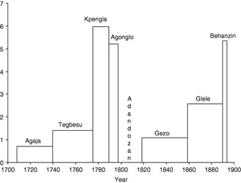
Archaeologists can estimate labor investment in monumental structures such as these by calculating the total volume of earth moved, based on field observation.Footnote 66 In this case, however, such an analysis would require detailed maps of all palaces identified, which are not presently available. Gross palace area, therefore, can be used as an approximate measure of labor investment in each structure. Dividing the total area of identified palaces attributed to each king by the number of years of each king's reign, one gains an approximate index of annual labor investment (in hectares per year) in royal palaces over time (Fig. 3).
Annual labor investment (hectares/year) in royal palace construction during the eighteenth and nineteenth centuries.

Labor investment in royal palace construction rose contemporary with political expansion and consolidation, or during the reigns of Agaja, Tegbesu (1740–75) and Kpengla (1775–89). However, the rate of construction dropped somewhat under Agonglo (1789–97), and fell to nothing under Adandozan (1797–1818). Numerous contests for power within the palace community are documented during the reigns of Kpengla, Agonglo and Adandozan.Footnote 67 These challenges culminated in at least one coup d'état, possibly two. The best-documented case involved Gezo, supported by the Brazilian slave trader Francisco de Souza and various ministers, in his seizure of the royal stool in 1818.Footnote 68 The declining rate of royal palace construction in the late eighteenth and early nineteenth centuries thus provides material evidence that these contests seriously weakened the monarchy. Palace construction rates recovered only later in the nineteenth century, just as Gezo and Glele successfully reconstituted royal power in Dahomey.
It is notable that not a single royal palace identified on the Abomey Plateau can be attributed, based on either historical or archaeological evidence, to the reign of Adandozan.Footnote 69 To date, archaeological data from excavations at these sites are admittedly limited. The lack of oral evidence may reflect well-documented royal attempts at erasing this king from Dahomey's historical memory.Footnote 70 Indeed royal traditions generally present Adandozan as a regent, an ideological strategy designed to legitimize Gezo's seizure of the royal stool.Footnote 71 However, despite attempts at shrouding Adandozan's place in Dahomey's dynastic history, he is still remembered by some traditional historians in Abomey as a legitimate king.Footnote 72 If royal propaganda failed to erase Adandozan's legacy within Abomey, it is very unlikely that these royal traditions would have done so in communities at a distance from Abomey. This suggests the real likelihood that Adandozan was unable to marshal the labor required to build a single royal palace on the Abomey Plateau while king.
It is commonly argued that Adandozan's fall was the product of dissatisfaction amongst the royal family and merchant traders because of undesirable royal policies initiated during his reign.Footnote 73 The archaeological evidence presented above begs us to ask whether or not he was relatively weak throughout his reign. This decline in construction rates coincides with a radical decline in royal profits from the slave trade. Indeed, Patrick Manning estimates that, from the 1780s to the 1790s, slave exports from Dahomey declined from approximately 102,000 to only 49,000 per decade, the lowest level in the eighteenth century. This must have represented a major blow to the legitimacy of the royal dynasty, contributing to the political disorder that characterized the period.Footnote 74 Given intense competition for power in the Dahomean court and declining revenue from Atlantic commerce in the last quarter of the eighteenth century, it is probable that Adandozan's chances of political success were slim from the start.
The pattern of palace construction outlined above permits a number of conclusions to be made about Dahomean regional control from the seventeenth through nineteenth centuries. Like Allada and Hueda to the south, Dahomey was only weakly centralized in the seventeenth century, yet expanded significantly during the eighteenth and nineteenth centuries. Dahomey was focused on centralizing control only over the slave route to the coast in the eighteenth century, however, and was relatively disinterested in managing activities in its general countryside. It is only in the nineteenth century, and more specifically by the reign of Glele, that we have archaeological evidence for significant state control across the plateau. Dahomean building programs in this period may have been geared towards centrally managing war, production and long-distance as well as local exchange, reflecting a growing domestic economy as well as an expanding state sphere. This archaeological pattern supports the argument that, despite periodic instability, Dahomey increasingly centralized its territories over the course of the eighteenth and nineteenth centuries in response to the changing demands of Atlantic commerce.
CONSTRUCTING BUREAUCRATIC ORDER
Archaeological research has suggested that elite architecture transforms dramatically with the development of centralized state institutions. As political organization becomes increasingly centralized and bureaucratic, archaeologists often witness an increase in spatial segmentation and control in elite facilities.Footnote 75 Segmented space serves to demarcate the large number of administrative, ritual or economic activities performed within such facilities. More importantly, however, manipulating the built environment is a particularly useful strategy for controlling social interaction. Politically centralized societies often materialize social hierarchy by regulating movement within state facilities, and by creating zones that are restricted to all but the highest-ranking members of society.Footnote 76 Because elite architecture is so sensitive to the nature of political order, the analysis of spatial patterns within royal spaces may shed light on political transformation in Dahomey.
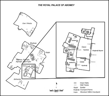
Historical references to the organization of space in the Abomey palaces support this argument. Oral traditions and period sources indicate that the various political, economic and ritual activities that took place within Dahomean palaces were, indeed, spatially segregated from one another.Footnote 78 A public area, which consisted of a large open courtyard called the singbodji, existed outside the southeast gates of the royal palace (Fig. 4). It was within this area that public ceremonies such as the Xwetanu were performed before the general populace. Behind the high walls of the royal palace, space was divided into two zones. A private zone, accessible by private gates in the rear palace wall, housed the king and his dependants and was generally off-limits to visitors. A second semi-public zone is also clear. This area is characterized by a complex series of courtyards, clustered against the palace walls, which served as a buffer zone between palace residents and visitors.
The Royal Palace of Abomey showing areas constructed by successive kings from the seventeenth through nineteenth centuries.Footnote 77

It was within the courtyards of this semi-public zone that the king received visitors, held court, resolved disputes and performed sacrifices before ancestral shrines. It was here that most matters of state were discussed and resolved, and elements of the state's ritual cycle were performed. These activities were restricted to discrete courtyards within the semi-public zone, reflecting a great deal of spatial segmentation. Additionally, of the male officials, only the highest-ranking were allowed into the deepest recesses of this area. Those of lower rank were generally restricted to courtyards adjacent to the palace gates, and members of the general populace were refused access entirely. The semi-public zone thus may be considered a region for inter-elite discourse, one that materialized political order in Dahomey.Footnote 79 An observed increase in the nature of spatial control and complexity in this zone would suggest parallel changes in the political sphere. The ground plans of four Dahomean royal palaces at Cana, spanning the reigns of Agaja through Glele, are examined here to evaluate this proposition.Footnote 80
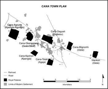
Cana was chosen over Abomey as a study site for a number of reasons. First, the royal palace at Abomey was the product of three centuries of accretionary growth. It would be a major undertaking, though one of considerable value, to attempt to reconstruct archaeologically the spatial layout of each successive palace wing at Abomey. In contrast, six detached palaces were constructed in Cana (Fig. 5). Oral traditions, period sources and archaeological evidence suggest that these palaces were built and briefly occupied by successive kings from the early eighteenth to the late nineteenth centuries.Footnote 81 Each palace thus represents a thin slice of time, relatively undisturbed by later occupation. Second, Cana became marginalized under French colonial rule. Its population declined dramatically, and its palace remains have been impacted little by settlement growth. Additionally, unlike the Abomey palaces, Cana has avoided extensive renovation projects in the twentieth century. Such projects at Abomey have, until recently, caused more destruction than preservation.Footnote 82 As a result I surmised that the palaces at Cana would be more useful for exploring architectural change over time in their ruinous, yet relatively unmolested condition.
Royal palaces (black) and the limits of modern settlement (grey) at Cana.

Most importantly, however, Cana played a central political role in Dahomey throughout its history. This town may have been the center of political authority on the plateau prior to the arrival of the Fon dynasty. Under Dahomey, Cana was widely cited as the usual residence of the king. Dalzel claimed, for example, that he resided there year round and only left for Abomey when the Xwetanu approached.Footnote 83 This led some to consider Cana the ‘country capital’ of the kingdom.Footnote 84 Each minister had a residence at Cana, permitting the entire administration to be available to the king at any given time.Footnote 85 Cana was also a centrally important site of interaction between Dahomey and the Oyo Empire for much of the eighteenth century, and Oyo maintained an ambassador there in this period. As J. A. Skertchly wrote, ‘Kana, next to Whydah, is the most important town in the kingdom’.Footnote 86 Thus Cana presented an ideal context in which to examine the nature of Dahomean political organization over time.
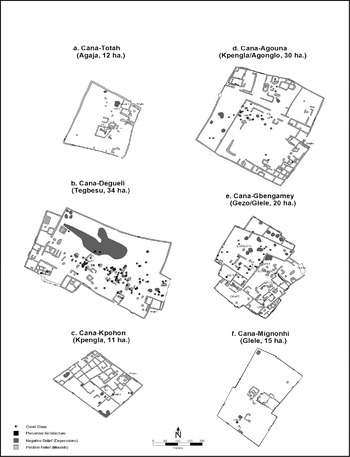
Oral traditions indicate that the earliest palace constructed at Cana was built during the reign of Agaja at Cana-Totah (Fig. 6a).Footnote 87 Documentary evidence supports this claim. Agaja reportedly resided at a palace called ‘Tota’ in 1733.Footnote 88 Bulfinche Lambe also indicated that ‘his majesty has ordered another house to be built for me at a town he mostly resorts to when he is preparing for war’,Footnote 89 and Cana served as a major launching point for many military campaigns in later years. Da Langanfin Glélé Aïhotogbé suggested that this structure was primarily a royal residence, but was also used to house slaves en route to the coast.Footnote 90
Plans of the royal complexes at Cana.

The palace of Agaja at Cana-Totah has a very simple ground plan characterized by a few small courts that appear to contain temple complexes and reception halls. The two interior zones of the palace, defined above as semi-public and private, are clearly visible. Specifically, the cluster of courtyards located in the northeast corner is quite similar to the semi-public zone described above for the Abomey palaces. Undulating and indistinguishable low mounds and depressions, as well as a few identifiable courtyards and structures characterize a large open area inside this palace. Composed of refuse mounds, borrow pits and the collapsed walls of smaller buildings, this area represents the private zone described above. The central features of this zone were three unconnected walled courtyards, two of which contained rectilinear I-shaped structures that may have served ritual functions.Footnote 91 Overall, however, the ground plan of this structure is relatively simple and undifferentiated.
The palace of Cana-Degueli is attributed to the reign of King Tegbesu (Fig. 6b).Footnote 92 Oral sources suggest that in addition to serving residential and administrative functions for the king, this structure also housed slaves en route to the coast on a regular basis.Footnote 93 Excavations within this palace did not yield datable European artefacts. However, decorative elements on locally produced ceramics suggested a mid-eighteenth-century construction and occupation date.Footnote 94
Although much larger than the palace at Cana-Totah, Cana-Degueli's ground plan indicates that Tegbesu's approach to palace construction was similar to that of his predecessor. Note the large domestic zone characterized by numerous mounds and depressions and a continuous scatter of fragmentary grinding-stones, a strong indicator of domestic activity. Numerous semi-public courtyards are also located along the southern, eastern and western walls of this palace. If these courtyards, like their counterparts at Abomey, served specialized political or ritual functions, then it is likely that the palace at Cana-Degueli accommodated a growing number of these activities. Although the specific nature of these activities remains unascertainable based on existing archaeological or oral evidence, this pattern is generally consistent with the argument that the government apparatus expanded under Tegbesu.Footnote 95
Royal informants suggested that Agonglo built the palace at Cana-Agouna (Fig. 6d).Footnote 96 Multiple informants living in compounds adjacent to the palace at Cana-Agouna, however, proposed that Kpengla built this complex.Footnote 97 One source suggested that the palace was constructed in two phases, the northern half by Kpengla and the southern half by Agonglo.Footnote 98 Oral sources also suggested that Cana-Agouna was abandoned ‘before Gezo’.Footnote 99 These sources present the strong likelihood that Cana-Agouna was constructed by Kpengla and abandoned after the reign of Agonglo or under Adandozan. An assemblage of European artefacts excavated from a low refuse mound near the center of Cana-Agouna dated tightly between 1775 and 1780, or early in the reign of Kpengla, firmly placing this structure in the late eighteenth century.Footnote 100
Spatially, the royal palace at Cana-Agouna clearly has much in common with the other complexes at Cana and Abomey. Note the large domestic zone in the center of the palace. Like the palaces of Agaja and Tegbesu, this area contained an undulating terrain of indistinguishable mounds and depressions, and a scatter of fragmentary grinding-stones. The semi-public zone, however, is characterized by a greater degree of internal complexity as well as formally segmented space. The semi-public zone itself is composed of a larger number of courtyards than at Cana-Degueli, particularly in the southeast corner. Furthermore, unlike that of Degueli, multiple large walls internally divide the palace at Cana-Agouna. These divisions formally separate the semi-public courtyard complexes from one another, as well as from the private zone as a whole. It thus appears that the palace at Cana-Agouna served a greater number of specialized activities than its predecessor and that these activities were formally demarcated, a pattern that may reflect similar transformations in the political sphere.
The palace of Cana-Gbengamey is attributed to both Gezo and Glele (Fig. 6e). Royal sources suggest that, like Cana-Agouna, Cana-Gbengamey was constructed in two phases, a northern section by Gezo, and a second section by Glele to the south.Footnote 101 Burton attributed Gezo with the construction of a palace called ‘Banyamme’, which was still occupied by Glele in 1863.Footnote 102 Skertchly also visited Glele at the ‘Banyanemme’ palace at Cana, and identified Gezo as its builder.Footnote 103 An assemblage of European artefacts excavated within a large refuse mound in this palace dated between 1828 and 1870, within the reigns of both kings.Footnote 104
Like its predecessor, the ground plan of the palace at Cana-Gbengamey is also complex. Numerous courtyards as well as major and minor dividing walls are again clear throughout this palace. Grinding-stones are limited to a single large area containing multiple mounds and depressions and walled off from the rest of the palace. Oral traditions from Cana support the argument that these clusters of courtyards served specialized functions. Based on recollections passed to him from his father, the King of Cana, Da Langanfin Glélé Aïhotogbé, proposed the locations of six functionally specific areas within this structure that served specific domestic, ritual, military, craft and administrative functions.Footnote 105 There is a near-perfect correlation between these areas and demarcations in the ground plan of Cana-Gbengamey. Oral evidence thus supports the argument that spatial segmentation reflects the quantity of specialized activities performed, as well as an attempt at formally demarcating such activities within Dahomean royal palaces. Future excavation at these sites will seek to validate this proposition.
Thus, available evidence suggests that space within Dahomean royal palaces became increasingly complex and controlling over time. Quantitative spatial analysis performed on the ground plans of the Cana palaces, reported elsewhere, supports this argument.Footnote 106 The rising spatial complexity of these palaces may reflect a similar rise in the quantity of specialized activities undertaken by the king and his officials. This interpretation complements historical evidence for an expanding bureaucratic structure over time. Additionally, the presence of monumental walls dividing and segmenting the private and semi-public zones by the late eighteenth century suggests greater control over internal access over time.
Bay's discussion of the growing importance of the Kpojito (queen) and a staff of female officials, or begani, by the late eighteenth century is relevant here.Footnote 107 Organized into a palace bureaucracy that duplicated that of the male officials of the outside, these women were particularly important for balancing the growing power of this latter group by the late eighteenth century. Indeed, Skertchly noted in the late nineteenth century that the king ‘effected the balance of power by creating she-officers, corresponding to the “outside” ministers, thereby checking any rebellious intentions that might enter the mind of any ambitious subject’.Footnote 108 Given the important role played by palace women in government affairs by the late eighteenth century, one would expect the king to seek to control interaction between his palace dependants and outsiders. This is exactly what the architectural ground plans introduced above suggest. It is probably not coincidental that the emergence of this architectural pattern in the late eighteenth century coincides with a period of major political change described above, namely a decline in relative royal power and its subsequent recovery and reconsolidation. Rising spatial control within the semi-public zone probably would have restricted contact between officials of the outside and those of the inside, diminishing the likelihood that these factions might effectively collude against the sitting king. This strategy may have contributed to the emergence of a more stable bureaucratic apparatus by the nineteenth century.
The architectural evidence presented here complements historical perspectives on the nature of Dahomean government in the eighteenth and nineteenth centuries. Documentary sources describe a complex bureaucratic apparatus, consisting of numerous officers distributed throughout the kingdom, which expanded dramatically over the course of the eighteenth and nineteenth centuries. In so much as the layout of Dahomean royal palaces can be used as an index of bureaucratic order, architectural patterns also suggest dramatic evolution in the political sphere. The sheer volume of activities taking place within royal palaces grew, and the staff of officers, both male and female, was formally integrated into a centralized administrative hierarchy.
CONCLUSION
Competing ideas have been presented regarding the nature of Dahomean political order in the era of the trans-Atlantic slave trade. On the one hand I. A. Akinjogbin highlighted the qualities Dahomean government had in common with the nation-state. For Akinjogbin, Dahomey created a bureaucratic government dependent upon a military ethos for maintaining order soon after its expansion to the coast. Dahomean government was thus a revolutionary innovation on the Slave Coast of West Africa. This argument has been revisited by a number of scholars in subsequent publications. David Ross, for example, also argued that Dahomey was radically different from its predecessors. However, Ross echoed the arguments of a number of eighteenth- and nineteenth-century observers, who concluded that Dahomean power was despotic in nature and rooted in militarism rather than administrative sophistication. In contrast, Robin Law has convincingly argued that, although Dahomey was, in fact, more militaristic than its predecessors, its government apparatus in the mid eighteenth century differed only in degree from those of Allada and Hueda. Furthermore, Edna Bay has illustrated how Dahomean political structure continued to evolve significantly over the course of the eighteenth and nineteenth centuries, and that growing militarism was only a secondary product of the general processes involved in Dahomean state-building.
The archaeological evidence outlined above suggests that royal control was limited to the capital prior to Agaja's conquest of the coast, yet expanded throughout the countryside in the eighteenth and nineteenth centuries. In support of the latter arguments, however, Dahomean government appears to have expanded in fits and starts. Indeed the distribution of royal palace sites in the eighteenth century indicates that regional control was initially directed towards controlling the slave route, and direct administrative control was not fully established across the Abomey Plateau until the reign of Glele. Thus, rather than a process of wholesale political realignment, regional expansion in Dahomey appears to have targeted the specific economic interests of the monarchy over the course of the eighteenth and nineteenth centuries. Furthermore, the process of regional expansion and consolidation was clearly wrought with potential for failure. Indeed the dramatic decline in palace construction in the late eighteenth and early nineteenth centuries is a powerful reminder of the diminishing ability of kings to maintain centralized control in this period.
Patterns identified in the spatial layout of Cana's palaces also suggest that Dahomey's bureaucracy expanded and transformed over the course of the eighteenth century. The number of specialized palace activities appears to have expanded in this period, and control over movement within palaces rose dramatically by the end of this century. This latter transformation was contemporary with a period characterized by major political upheaval and subsequent recovery. These architectural patterns suggest that regulating interaction between increasingly influential male and female official factions contributed to political recovery and long-term order in Dahomey.
Arguments for radical political change immediately following the reign of Agaja are, therefore, clearly not in agreement with the archaeological evidence presented, yet dramatic governmental realignment did take place over time. Although administrative rather than military strategies for achieving order have been highlighted here, it has not been the intention of this essay to refute the importance of militarism in Dahomey. Dahomey may indeed have been, at least in part, a military state. Yet it was much more than that as well. Indeed, as Bay suggested, ‘Dahomey was neither a military state nor a state with warring as its raison d'être. A military spirit was part of a larger pattern of ritual and political strategies to promote the well being of the state’.Footnote 109
Long-term political stability in Dahomey was facilitated by the creation of a centralized state bureaucracy designed to project royal control over critical economic interests. This bureaucracy was built upon existing political foundations, flexibly redesigned and expanded to deal with the changing dynamics of internal Dahomean politics as well as the shifting tides of the Atlantic trade. By the nineteenth century, Dahomey emerged from this tumultuous era with a government system clearly more effective at centralizing administrative control over its interests than its predecessors on the Slave Coast. Thus, although Dahomey may not have brought about a ‘revolution’ in political order, it clearly represents dramatic ‘evolution’ in the nature of administrative organization on the Slave Coast of West Africa.