Introduction
The latitudinal gradient approach is predicated on comparisons of otherwise similar habitats across a range of locations (Howard-Williams et al. Reference Howard-Williams, Hawes and Gordon2010). Maximizing the probability of identifying differences between locations requires that sites are well enough constrained to allow inter-location differences to be identified as distinct from intra-site variations. Selection of habitat types that are simple and common enough to be replicated across a range of geographic scales facilitates this. For inland aquatic systems, which are often foci of biological production and diversity (Quesada et al. Reference Quesada, Fernández-Valiente, Hawes and Howard-Williams2008), this excludes the relatively rare but large lacustrine samples, but is met by the comparatively simple rock- and ice-based meltwater pond systems that are common across the Ross Sea latitude gradient.
Two of the key questions of the Latitudinal Gradient Project (LGP) can be applied to inland, meltwater ponds as aquatic habitats: 1) how does ecosystem function change with latitude and why, and 2) how does climate affect the availability and composition of free water (Howard-Williams et al. Reference Howard-Williams, Peterson, Lyons, Cattano-Vietti and Gordon2006). In order to make a meaningful comparison between latitudes, however, the habitat and ecology of meltwater systems needs to be adequately characterized for representative catchments at each latitude. The diversity of meltwater pond biology and geochemistry observed in various catchments of the ice-free areas of Victoria Land (e.g. Webster et al. Reference Webster, Brown and Vincent1994, Healy et al. Reference Healy, Webster-Brown, Brown and Lane2006) means that such characterization requires the sampling of a significant number of representative ponds, preferably across different years and seasonal conditions.
Limited access to remote field areas such as the Darwin Glacier Valley (80°S) make characterization difficult. We were fortunate enough to be able to visit this area in two consecutive field seasons (2007/08 and 2008/09), to undertake biological and geochemical characterization of the meltwater ponds in this region. Previously the only data from this region were from a limited number of ponds in the Lake Wilson/Diamond Hill area sampled in 1991 and 1993 (Vincent & Howard-Williams Reference Vincent and Howard-Williams1994, Timperley Reference Timperley1997), and from the large proglacial lake east of Diamond Hill, Lake Wilson (Hendy Reference Hendy1975, Webster et al. Reference Webster, Hawes, Downes, Timperley and Howard-Williams1996, Reference Webster, Webster and Hawes1997). The purpose of this study was to augment these data sufficiently to provide a regionally representative dataset for pond aquatic systems at 80°S, which can then be compared with the better-characterized inland meltwater systems in northern Victoria Land (e.g. Webster et al. Reference Webster, Brown and Vincent1994, Jungblut et al. Reference Jungblut, Hawes, Mountfort, Hitzfeld, Dietrich, Burns and Neilan2005, Healy et al. Reference Healy, Webster-Brown, Brown and Lane2006, Taton et al. Reference Taton, Grubisic, Balthasart, Hodgson, Laybourn-Parry and Wilmotte2006).
Study sites
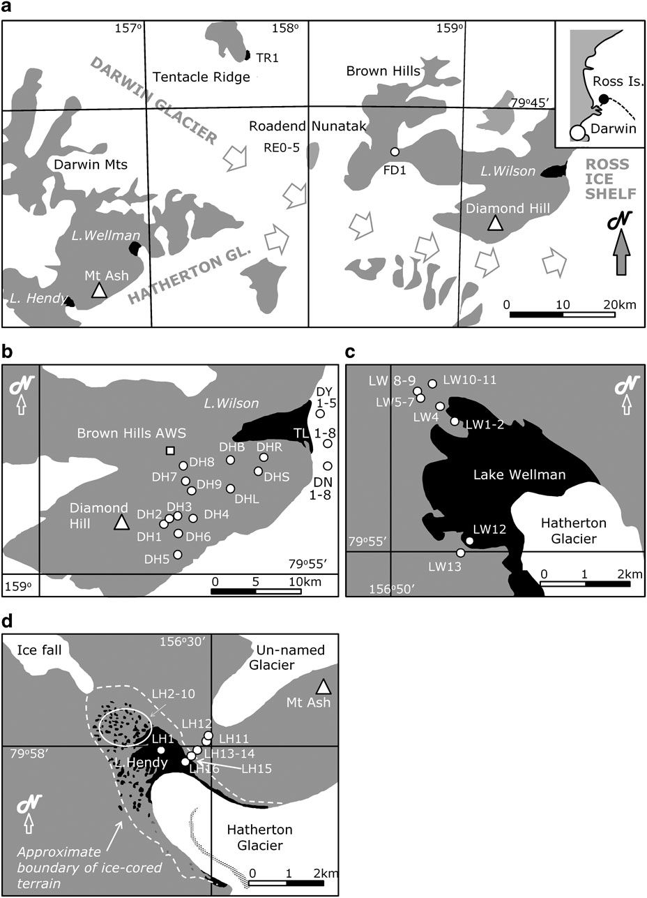
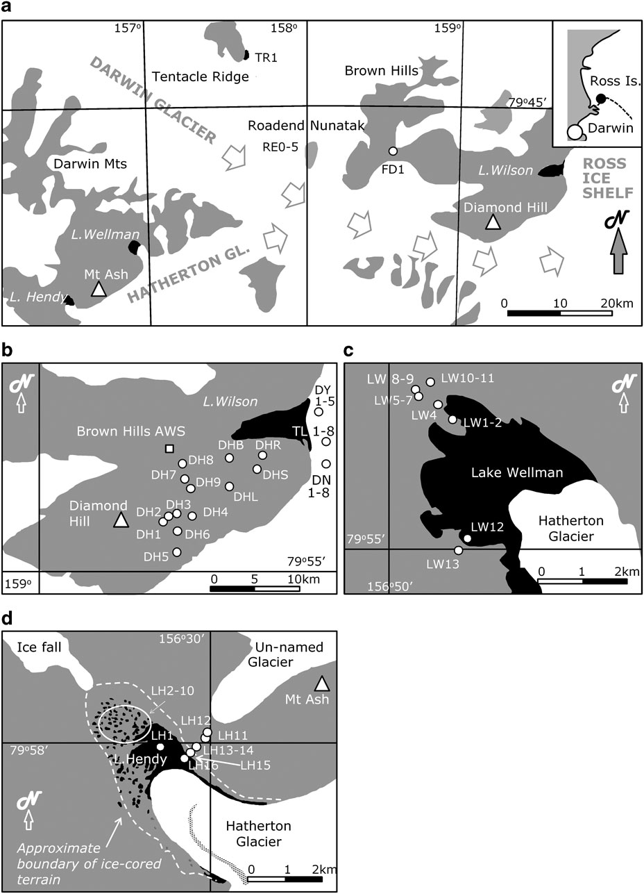
The ice-free areas of the Darwin Glacier region border the Darwin and Hatherton glaciers (Fig. 1a). Ponds were sampled from the south-east flank of Diamond Hill and the surface of the lower Darwin Glacier (Fig. 1b), the Lake Wellman area (Fig. 1c), and the Grant Valley (Fig. 1d) which includes Lake Hendy. These last two sites are glacial valleys extending from the north side of the Hatherton glacier, and have a glacial tongue extending onto a named “lake” feature at the terminus. Both lakes are believed to be permanently frozen to their base (Hendy Reference Hendy2000), an idea supported by the authors’ own observations of lake ice behaviour in Lake Hendy, and recently completed GPR seismic profiles of Lake Wellman (Mette Riger-Kusk, Gateway Antarctica, personal communication 2009). The meltwater ponds occurring around the margins of these lakes are in ice-cored terrain (glacial moraine resting on remnants of glacial ice). A single pond at the glacier margin at Tentacle Ridge was included (Fig. 1a), and samples of snow and glacial ice were collected at Roadend Nunatak (RE0–5), the location of the LGP camp in the 2008/09 field season.
a. Location of sampling sites in the Darwin Glacier region, with enlargements of b. Diamond Hill/lower Darwin Glacier, c. Lake Wellman, and d. Lake Hendy in the Grant Valley. Note that names used for features in this area are those in standard usage, and may differ from those officially sanctioned. White = ice-covered, grey = ice-free areas and black = large water features (may be frozen solid).
Supraglacial ponds were sampled from the surface of the lower Darwin Glacier, from three distinct, but possibly interconnected, drainage systems; the “Dreary”, “Tropical” and “Darwin” (unofficial names) pond systems. Each system included at least one large pond, surface stream systems, and abundant cryoconites. Cryoconites are vertical, cylindrical melt holes on the glacier surface (e.g. see Hawes et al. Reference Hawes, Howard-Williams and Fountain2008), usually < 1 m in diameter, and with a sediment layer at the base. They are an abundant and widely distributed habitat type and host consortia of microorganisms (e.g. Bagshaw et al. Reference Bagshaw, Tranter, Fountain, Welch, Basagic and Lyons2007).
All catchments areas were characterized by an arid, windy climate. Between November 2003 and November 2007, an Automatic Weather Station (AWS) stationed in the Brown Hills (position shown on Fig. 1b) recorded mean monthly temperatures ranging from -2 to -29°C, wind speeds from 4–17 m.sec-1 and relative humidity from 33–60.5%. January and February were consistently the months with the highest temperatures, and lowest wind speeds. The basement rocks of the Darwin Glacier region are granitoids of Cambrian age (Simpson & Cooper Reference Simpson and Cooper2002). However, the valley floors are almost entirely covered by glacial moraine and a “soil” substrate of pebbly gravels, sands, silts and evaporite salts. A high salt content in the soils of other ice-free inland environments has been previously reported (e.g. Keys & Williams Reference Keys and Williams1981, Webster et al. Reference Webster, Brown and Vincent1994) and attributed to salt concentration caused by evaporation and ablation in the drainage basin. Because pond geochemistry is likely to reflect ongoing dissolution of the abundant soil salts, adequate characterization of the soil salts, both close to and at a distance from ponds, was undertaken as part of this study.
Methods
Sample collection and field measurements
Location of study areas and all sampled ponds are shown on Fig. 1a–d. Meltwater ponds were variable in shape, ranging from 2 cm to > 2 m in depth and < 1–100 m diameter or distance across. Ponds on Diamond Hill were sampled between 22–26 December 2007 (DHR, DHS, DHB, DHL) and in January 2009 (DH1–9). Supraglacial ponds and cryoconites on the lower Darwin Glacier were sampled, between 22–26 December 2007, for the three distinct drainage systems; Dreary Pond (DY1–10), Tropical Pond (TL1–10) and the Darwin Pond (DN1–10). In 2009, ponds in the Grant Valley were sampled between 19–21 January, those at Lake Wellman between 23–25 January, and the Tentacle Ridge pond was sampled on 26 January. Pond elevations (a.s.l.) ranged from: 55–70 m for the lower Darwin Glacier ponds and 90–530 m for the Diamond Hill ponds, to 740–980 m for the Grant Valley, Lake Wellman, Roadend Nunatak areas and for Tentacle Ridge pond.
All ponds were either entirely thawed, or had marginal moat melt at the time of sampling, except for those at the Grant Valley which had a 1–10 cm ice cover even at the margins, and were often evidently frozen solid at the centre, and Tentacle Ridge Pond (10 cm ice cover at margin). Also, all cryoconites were ice-covered. Where an ice cover was present this was either drilled using a ice auger (5 cm diameter hole), or broken carefully with an ice axe.
Upon reaching a pond, the first samples taken were for dissolved inorganic carbon (DIC). Triplicate samples (2 ml) were taken directly from the undisturbed water using a surgical syringe and dispensed into gas tight tubes (details below). Then temperature, pH, dissolved oxygen and conductivity were then measured in situ using calibrated portable meters. Water samples were extracted from the pond using a hand vacuum system, or by direct collection in the absence of ice cover, into clean, rinsed HDPE containers. Macroscopic morphology of the cyanobacterial mats was noted where visible. Cores of microbial mat were collected from near the edge of the ponds, in triplicate, into 15 ml sterile Falcon tubes using a 60 ml syringe corer (area 6.6 cm2). Further sediment samples were also collected into a 60 ml Falcon tube, and where mats were not observed, this was the only substrate collected.
Soils (100 g), soil salts and pond salt precipitates were collected into airtight vials. Samples were transported back to the camp facilities for further sub-sampling and processing.
Major ions, trace elements, isotopes and salts
Unfiltered water samples (50 ml) were analysed for Na, K, Ca and Mg by atomic absorption spectrometry (AAS), for which detection limits were 0.01 mg.l-1 for K, 0.03 mg.l-1 for Mg, and 0.05 mg.l-1 for Ca and Na. For Cl, NO3 and SO4, samples were analysed by high performance ion chromatography (HPIC), for which detections limits were 0.05 mg.l-1 for SO4 and NO3 and 0.1 mg.l-1 for Cl. Excellent agreement was observed between HPIC NO3 and NO3 recalculated from the nutrient analyses described in the following section. Therefore HPIC NO3 has been used for those ponds for which nutrient samples were unable to be collected (e.g. as in the Lake Wellman area).
For samples for which dissolved inorganic carbon (DIC, see below) had been determined, HCO3 concentrations were calculated from DIC, as HCO3 would be the dominant carbonate ion over the pH range observed in the ponds. For ponds for which DIC analysis was not undertaken, analysis for HCO3 was by titration against standardized HCl on a 50 ml unfiltered water sample, which had been collected without air inclusion and kept sealed until the moment of titration. The detection limit was 1.0 mg.l-1 HCO3. A comparison of duplicate samples which had been titrated, and analysed for DIC, showed titration HCO3 concentrations consistently 10 mg.l-1 higher, reflecting uptake of CO2 from the atmosphere during the titration. Thus, where the titration data was used (e.g. for ponds in the Lake Wellman area) an appropriate correction was made. The charge balance for the major ions (including nitrate) was always within 10%, and usually within 5%.
Stable isotopes were determined using mass spectrometry (by GNS, Wellington, New Zealand) on unfiltered water samples; 50 ml for 18O, 2H (deuterium), and 1000 ml for 3H (tritium). Finally, the mineralogy of salts precipitated in pond sediments and in soils was identified using X-ray diffraction (XRD) and scanning electron microscopy (SEM).
Dissolved and particulate nutrients
For DIC determinations, 2 ml samples were injected into gas tight tubes (12 ml) containing pre-dispensed aliquots of phosphoric acid (0.2 ml) and sealed with injectable stoppers. Prior to water sampling, a volume of air equivalent to the anticipated sample volume was withdrawn from the tubes to ensure pressure equilibrium. After equilibration between liquid and headspace, DIC was measured as CO2 by injecting a sub-sample of the headspace directly into a stream of nitrogen gas, which then passed through the measuring channel of a Li-Cor Infra Red Gas Analyser (IRGA). DIC concentration was estimated from peak height using suitable calibration standards and blanks.
Dissolved species of N and P were determined on samples which had been filtered through acid-rinsed GF/F filters, then frozen for return to New Zealand. Nitrate + nitrite, ammoniacal N (NH4-N) and dissolved reactive P (DRP) were measured using an Astoria autoanalyser. Nitrite was not determined separate from nitrate as previous studies showed this to be a small proportion to the total nitrogen budget (Vincent & Howard-Williams Reference Vincent and Howard-Williams1994). Dissolved organic N (DON) and organic P (DOP) were analysed as NH4-N and DRP respectively, after persulphate digestion using a Lachat flow injection analyser (FIA). Samples for dissolved organic carbon (DOC) were also filtered (precombusted Whatman GF/F) and stored refrigerated in pre-cleaned amber glass bottles for return to New Zealand. DOC was determined by catalytic oxidation and IR detection according to the standard APHA method 5310-B (Eaton et al. Reference Eaton, Franson and Clesceri2005).
Detection limits for N, P, DIC and DOC were 1.0, 1.0, 100 and 500 μg.l-1 respectively. DRP and DOP concentrations were commonly at or below the detection limit of 1 μg.l-1. However, data are reported to 0.1 μg.l-1 precision for comparison with other literature.
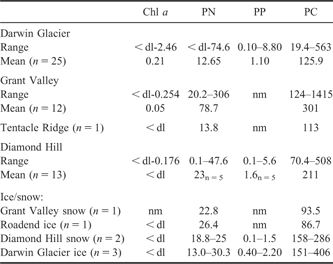
Suspended particulates for determination of chlorophyll a (chl a), and of particulate carbon (PC), nitrogen (PN) and phosphorus (PP), were collected from known volumes of water onto Whatman GF/F filters and frozen for up to three months prior to analysis. Chlorophyll a was determined fluorometrically after grinding in 90% acetone, according to the method of Strickland & Parsons (Reference Strickland and Parsons1968) with an effective detection limit of 0.01 μg.l-1. Samples for PN and PP (collected onto acid-washed filters) were digested by micro-Kjeldahl with concentrated H2SO4 and analysed as NH4-N and DRP by FIA. PC collected onto precombusted filters was determined using an Elementar Vario EL III CHN analyser. Detection limits were 1 ug.l-1 for PN and PC, and 0.1 ug.l-1 for PP.
Species identification and community structure analysis
Samples for identification of phytoplankton composition were preserved in unfiltered 2.5% glutaralehyde (for the 2007 samples) and Lugol’s Iodine (for the 2009 samples) and enumerated at 400x magnification using an inverted microscope (CKX41, Olympus). Sub-samples (100 ml) were allowed to settle for > 4 days in measuring cylinders, then the top 90 ml was aspirated off and the remaining sample re-settled in Ütermöhl settling chambers (Ütermöhl Reference Ütermöhl1958). Species identifications were made primarily by reference to Prescott Reference Prescott1982, Komárek & Anagnostidis Reference Komárek and Anagnostidis2000, Reference Komárek and Anagnostidis2005, John et al. Reference John, Whitton and Brook2002).
Total bacterial numbers were determined by flow cytometry using a FACSCalibur instrument (Becton Dickinson) with CellQuest ver. 3.3 software, using glutaraldehyde-preserved samples for 2007 sampling, and triplicate unfiltered samples, snap frozen and stored in a liquid nitrogen dry shipper, for 2009 sampling events. Samples were prefiltered through a 5 μm filter, stained using SYBRII stain (Molecular Probes Inc.) and incubated in the dark for 10–15 min before analysis following the methods described in Lebaron et al. (Reference Lebaron, Parthuisot and Catala1998). The sheath fluid contained 0.2 μm filtered de-ionized water and the sampled volume was calculated using tracer TrucountTM (Becton Dickinson) beads added just prior to analysis.
Samples for assessment of bacterial community structure by Automated Ribosomal Intergenic Spacer Analysis (ARISA) were collected onto sterile Acrodisc filters (0.22 μm) by filtration using a sterile 60 ml syringe. Disks were stored frozen until analysis (see below).
Microbial mat and sediment samples were stored frozen prior to analysis. On return to New Zealand, the dominant cyanobacterial genera in microbial mats or sediment samples were identified using an Olympus light microscope (BX51, Olympus). A subset of samples were used to describe bacterial and cyanobacterial community structures using ARISA (see below) and a second subset freeze-dried for pigment and elemental analysis.
Pigments were extracted from known weights of freeze-dried benthic material, at 4°C for 4 hr in 95% acetone after pulsed probe sonication (15 sec; Downes et al. Reference Downes, Hrstich and Vincent1993). A Dionex HPLC system, with PDA-100 diode array detector (300–800 nm), separated pigments according to the chromatographic method of Zapata et al. (Reference Zapata, Rodriguez and Garrido2000). Particular attention was paid to chl a and readily identifiable pigments that are diagnosic of specific taxonomic groupings; chl b and chl c, fucoxanthin, diatoxanthin, myxoxanthophyll, lutein and zeaxanthin. Pigments were quantified at 436 nm by reference to commercially available standards; chl a, chl b, lutein and β,β-cartoene (Sigma); alloxanthin, butanoyl-oxy-fucoxanthin, chl c3, c2, diadinoxanthin, hexanoyl-oxy-fucoxanthin, peridinin, fucoxanthin, myxoxnathophyll, prasinoxanthin and violaxanthin (DHI). Uncalibrated pigments were quantified using published extinction coefficient data according to the method outlined in Wright & Mantoura (Reference Wright and Mantoura1997). An internal standard (trans-β-Apo-8′-carotenal – Fluka) was added to the extraction solvent to monitor recovery.
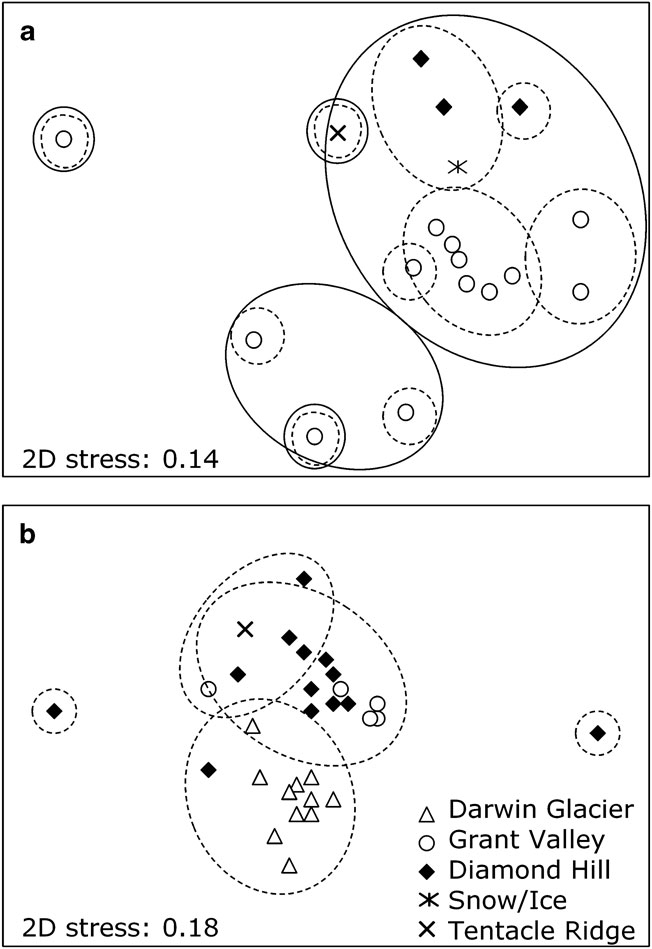
For samples collected in January 2009, ARISA was used to assess bacterial community structure in both planktonic and benthic samples. Planktonic DNA was extracted from Acrodisks using a PureLink™ Genomic DNA kit following the gram negative bacteria protocol (Invitrogen, CA, USA). DNA was extracted from sediment or microbial mat material using a MoBio Power Soil™ kit (Carlsbad, CA, USA). ARISA PCR reactions followed the protocol described in Wood et al. (Reference Wood, Rueckert, Cowan and Cary2008), using cyanobacteria-specific primers described therein, and the universal bacterial primers ITSF and ITSReub from Cardinale et al. (Reference Cardinale, Brusetti, Quatrini, Borin, Puglia, Rizzi, Zanardini, Sorlini, Corselli and Daffonchio2004). Amplicon lengths were resolved on a Megabace 500 series capillary sequencer (Amersham Pharmacia, Sunnyvale). ARISA fragment lengths (AFL) that were less than three standard deviations above the baseline ‘noise’ were removed from the analysis using the software T-RFLP Stats (Abdo et al. Reference Abdo, Schüette, Bent, Williams, Forney and Joyce2006). ARISA fragment lengths were then analysed using nonmetric multidimensional scaling (MDS) based on Bray-Curtis similarities using the PRIMER 6 software package (PRIMER-E, Ltd., UK). Nonmetric MDS was undertaken with 100 random restarts and results were plotted in two-dimensions. Agglomerative, hierarchical clustering of the Bray-Curtis similarities was undertaken using the CLUSTER function of PRIMER 6 and plotted onto the two-dimensional MDS’s.
Fresh or frozen mat/sediment samples (after thawing) under a dissecting microscope. Individual animals were isolated using a small plastic syringe and transferred to a microscope slide for further study. Animals were identified by comparison with illustrations in the literature (rotifers: Murray Reference Murray1910, Dartnall Reference Dartnall2000, tardigrades: Dastych Reference Dastych1991, Pilato & Binda Reference Pilato and Binda1999, Binda & Pilato Reference Binda and Pilato2000, nematodes: Andrassy Reference Andrassy1998).
Results
In the following text pond FD1, a pond near the terminus of the Foggy Dog Glacier (Fig. 1a) has been included within the Diamond Hill Pond group, due to its similar setting and characteristics.
Physical properties
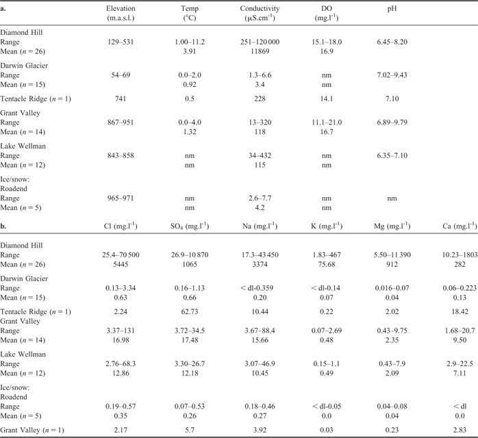
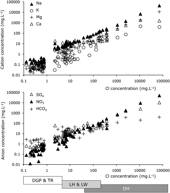
The physical properties and concentrations of major ions for meltwater ponds, snow and ice are summarized for each area in Table I and plotted in Fig. 2. Terrestrial ponds on Diamond Hill typically had the highest conductivities, followed by those of Grant Valley, Tentacle Ridge and Lake Wellman, and then by the recent ice melt in the supraglacial ponds on the Darwin Glacier, in which conductivities were very similar to those of snow and ice collected from the surface of the Darwin Glacier (Table Ia, also shown at base of Fig. 2). Some of the Diamond Hill ponds showed the salinity stratification that has been reported from other inland pond systems of Victoria Land. Pond DHR on Diamond Hill (Fig. 1b), for example, showed an increased salinity at the base of the water column, with conductivity changing from 1830 to 2800 μS.cm-1 (depth 350 cm). Similarly pond FD1 (Fig. 1a) showed an increase from 3180 to 7450 μS.cm-1 (depth 3.1 m) and pond DHL (Fig. 1b) an increase from 770 to 3740 μS.cm-1 (depth 1.75 m). In all except FD1 pond, however, this brine layer was thin and could not be reliably sampled separately from the rest of the water column.
a. Summary of field parameters, and b. major ion concentrations for ponds (unless noted otherwise), ice and snow of the Darwin Glacier region. Refer to Fig. 1 for site locations. nm = no measurement made. Concentrations below detection are denoted “< dl”, and for mean calculations < dl values have been assigned a zero value.

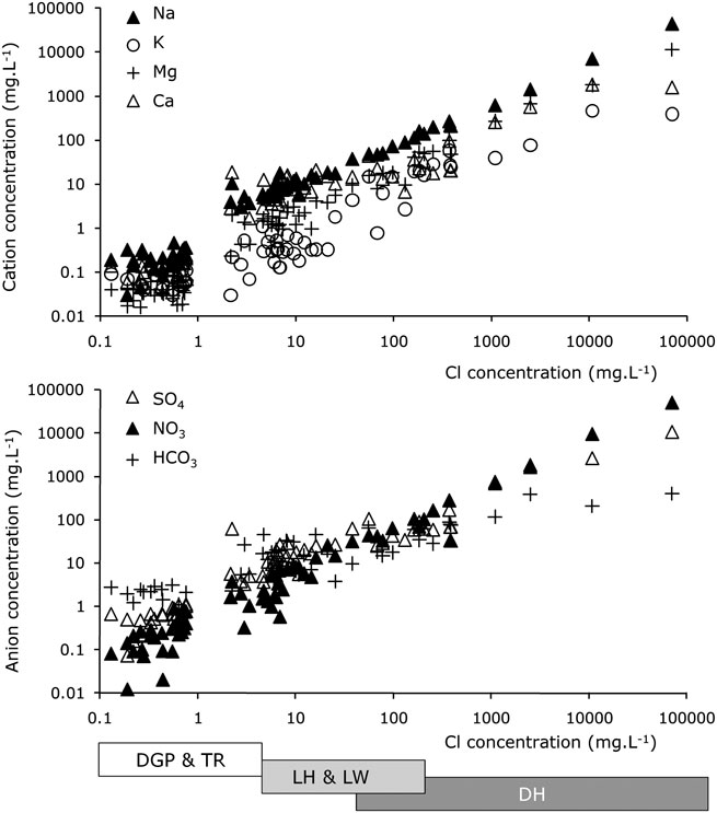
Major ion vs Cl relationship for pond waters of the Darwin region. The range of Cl values exhibited in each catchment sampled is also shown.
The pH values ranged from 6.6–9.5 and did not demonstrate any consistent trend with conductivity, although elevated pH occurred most frequently in the dilute waters of the Grant Valley (Fig. 1b) and in the supraglacial pond systems on the lower Darwin Glacier (DY, TN and DL on Fig. 1c). All ponds were well aerated, and saturated or oversaturated with respect to dissolved oxygen, which ranged from 14.1 mg.l-1 to > 20 mg.l-1 (the operational upper limit of the meter), with the highest concentrations occurring in the supraglacial ponds on Darwin Glacier, when measured in late December 2007 (the warmest period).
Major ion and isotope geochemistry
Major ion concentrations reflected the conductivity, with a positive linear relationship between Cl, a conservative ion not readily precipitated or removed during freeze thaw or evaporation processes, and major cation and other major anion concentrations (Fig. 2). Strong linear relationships with Cl were seen for Na and NO3, indicating that very similar processes control the concentrations of these ions. The poorest linear relationships with Cl were seen for K and HCO3. For K this could be due to generally low concentrations, which increased the analytical error of measurements in the most dilute waters. For HCO3 this is likely to reflect atmospheric exchange of CO2 and/or photosynthetic depletion.
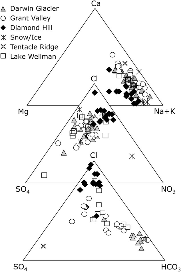
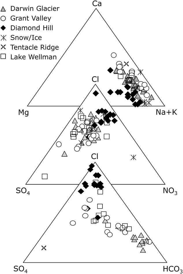
The proportional contribution of each ion to cationic chemistry (Fig. 3) indicated that all ponds were Na-dominated, although Ca was also a relatively abundant ion, particularly in the ponds associated with the glaciers and glacier margins (Lakes Hendy and Wellman, Tentacle Ridge and the supraglacial pond systems). For the anions there was a clear distinction between the Cl-dominated terrestrial ponds of Diamond Hill, and glacier-associated water bodies, which included a more significant HCO3 contribution, or were HCO3-dominated. Only Tentacle Ridge showed a Na-SO4 composition. Although not usually a dominant ion in meltwaters, NO3 makes a significant contribution to anion chemistry in many of these waters (Fig. 3), and has therefore been included as a major ion in these discussions.
Major ion concentrations (as mole % of total anion or cation concentrations) plotted as ternary diagrams for meltwaters features of the Darwin Region.
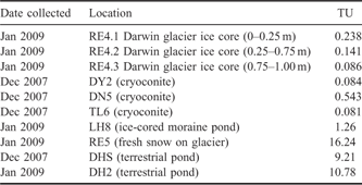
Tritium isotopes (Table II) fall mainly into two distinct ranges:
Tritium (TU units) in selected water features of the Darwin Region.
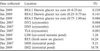
i) Those with > 9 TU, indicating a derivation from precipitation that has occurred in years since the first nuclear bombs (i.e. < 60years old). This group includes the freshly precipitated snow on the Upper Darwin Glacier (at RE5), and ponds on Diamond Hill.
ii) Those with < 1 TU, indicating derivation from pre-nuclear age precipitation. This group includes the ice of the Darwin Glacier (RE4.1–4.3), and the three cryoconites sampled.
Pond LH8 in the Grant Valley, in ice-cored terrain, had an intermediate TU value, possibly indicating a mixed glacial ice and recent snow origin for the pond waters.
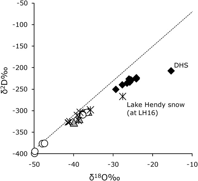
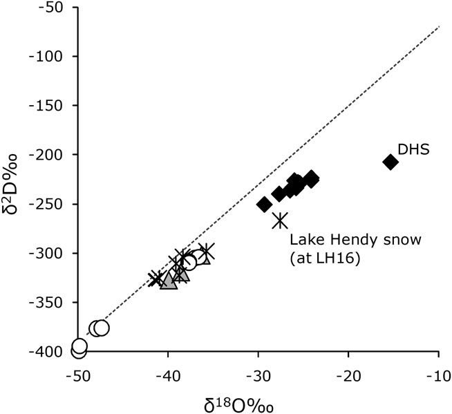
Stable oxygen and hydrogen isotopic ratios covered a considerable range over the region (see Fig. 4). The lightest isotopic signatures were from the ponds in ice-cored terrain at the north-west end of Lake Hendy in the Grant Valley (LH1–10; δD < -370‰ and δ18O < -47‰). However, ponds in the same valley but at higher elevation and near the terminus of a small glacier (LH11–15) had somewhat heavier isotopic signatures, similar to those of snow (RE0 & RE5), ice (RE4.1–4.3), supraglacial ponds of the Darwin Glacier and the pond at Tentacle Ridge (TR1). These samples remained close to the SMOW line. The terrestrial ponds of Diamond Hill had the heaviest isotopic signatures and also deviated from the SMOW fractions line. The highly saline DHS pond was the most extreme example, with δD -207‰ and δ18O -15.3%. Similarly snow collected from the surface of Lake Hendy (LH16) was enriched in 18O.
Stable isotopes δ18O and δ2D for Darwin regional waters. The dashed line represents the fractionation line for SMOW, along which water samples undergoing fractionation (only) due to evaporation and meteoric precipitation are expected to plot. Legend as for Fig. 3.
Salt mineralogy
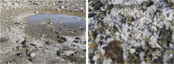
Mineral salts collected from the margins of the ponds at Diamond Hill were mainly nitratine (NaNO3) with some gypsum (CaSO4.2H2O) and halite (NaCl). Cubic crystals of nitratine at the margin of Saddle Pond (DHS) are shown in Fig. 5. Saline DHS pond was also actively precipitating coarse crystals of pink gypsum at the centre of the shallow brine pool.
DHS pond near Diamond Hill. The pond is very saline, and c. 3 m across. The enlargement below shows crystals of nitratine (NaNO3) salt in the evaporite salts at the pond margin. Crystals are typically 3–4 mm in size.

In the Grant Valley and at Tentacle Ridge, pond margin salts were predominantly thenardite (Na2SO4), accompanied by gypsum, particularly as encrustations on exposed rock surfaces in the shallow margin of the pond. Minor occurrences of other salts, such as darapskite (Na3(NO3)(SO4).H2O and hexahydrite (MgSO4.6H2O) were noted. Away from the immediate vicinity of ponds, soil salts and salt encrustations on rock surfaces were either gypsum or calcite (CaCO3).
Nutrient chemistry
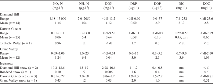
Dissolved inorganic and organic nutrient concentrations are summarized in Table III. After nitrate (NO3-N), the next most abundant nutrient was dissolved organic nitrogen (DON), followed by ammonia (NH4-N), then DIC and DOC. The concentrations of organic and inorganic phosphorous nutrients (DOP and DRP respectively) were extremely low.
Dissolved nutrients concentrations in waters of the Darwin Glacier region. Means have only been calculated when n > 3, and values of < dl have been allocated a zero value for mean calculation.
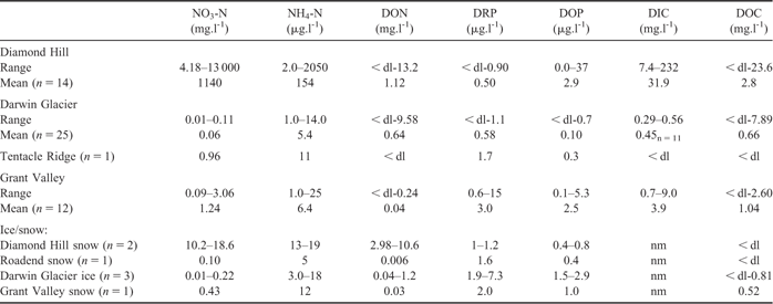
Nitrate concentrations were highest in the more saline ponds of Diamond Hill, intermediate in ponds of ice-cored terrain around Lakes Hendy and Wellman, and lowest in the supraglacial systems of the Darwin Glacier. Concentrations were often higher than 2 mg.l-1; a value considered high by Vincent & Howard-Williams (Reference Vincent and Howard-Williams1994), with a maximum concentration of 13000 mg.l-1 found in DHS pond. The linear correlation between NO3-N and conductivity reported by Vincent & Howard-Williams (Reference Vincent and Howard-Williams1994) was also apparent in the data from this study data (Fig. 2). Highly elevated concentrations of DON occurred throughout the region, particularly in both Diamond Hill and supraglacial ponds but also in snow/ice samples from these locations. Maximum DON concentrations were 13.2 mg.l-1 in Diamond Hill ponds, and 9.58 mg.l-1 in the supraglacial ponds.
By contrast, ammonia concentrations were only significantly elevated above the concentrations found in ice and snow (maximum 19 μg.l-1) in the terrestrial ponds of Diamond Hill (maximum 2050 μg.l-1). P concentrations were universally low, although ponds in ice-cored moraine in the Grant Valley had elevated DRP and DOP relative to many of the terrestrial rock-based ponds and to the supraglacial ponds, cryoconites, ice and snow. Of the ponds on Diamond Hill, only the most saline pond (DHS) had a DOP concentration significantly above 1 μg.l-1, at 37 μg.l-1, although DRP remained below detectable levels.
DIC concentration ranges were relatively constrained, from very low values in supraglacial meltwaters (< 0.6 mg.l-1) to an order of magnitude higher in terrestrial ponds (> 10 mg.l-1), with marginally elevated concentrations observed in the Grant Valley (also see Fig. 2, where DIC is represented as HCO3). DOC was generally higher in the terrestrial ponds compared to supraglacial ponds and cryoconites. However, relatively high DOC concentrations were measured in two streams feeding the large supraglacial pond systems: 7.89 mg.l-1 in the Darwin Pond (DN) system, and 1.95 mg.l-1 in the Dreary Pond (DY) pond system on the Darwin Glacier surface. Traces of biological material and foam were observed on the surface of the Darwin Pond stream water.
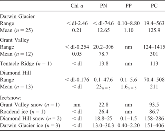
Particulate nutrient concentrations (PN, PP and PC) and ratios of PC:PN and PN:PP are typical of those present in a dilute water, in which suspended material is predominantly of biological origin (Table IV). The PC:PN ratios are consistently low (< 10), as might be expected for these high N (NO3 and DON) systems. It is, however, interesting to note that concentrations in snow and ice are comparable to those of the pond waters, suggesting perhaps wide distribution of wind-blown particulate nutrients from the beds of the ponds than have recently dried out, such as those on Diamond Hill. The low chl a in the ice and snow (Table IV), however, suggest that these nutrients have not been exported in an active autotrophic unit (e.g. active benthic mat detritus). Chlorophyll a concentrations were low throughout the catchment, indicative of predominantly oligotrophic, even ultra-oligotrophic conditions, in all waters. Chlorophyll a was either below detection, or at barely detectable levels (< 0.02 μg.l-1) in all SGP ponds except the cryoconites and ponds of the Dreary Pond system, where concentrations of up to 2.46 μg.l-1 (meann = 4 = 1.2 μg.l-1) were measured. The Diamond Hill ponds had a maximum chl a of only 0.176 μg.l-1, and those of the Grant Valley, a maximum of 0.25 μg.l-1.
Meltwater chl a and particulate nutrient concentrations (μg.l-1). nm = not measured.
Phyto and bacterio-plankton
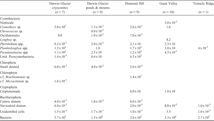
Although of low abundance, phytoplankton were present in the water columns of all ponds sampled (Table V). Cyanobacteria were the most abundant group of organisms in the plankton, and showed greatest diversity, followed by cryptophytes, chlorophytes and diatoms, the last of which were rare. Dominant cyanobacteria were filamentous, motile species of the Oscillatoreaceae and included species of Planktolyngbya, Pseudanabaena but also included unicellular picocyanobacteria and a large (> 20 μm) Cyanothece. Cyanothece was particularly abundant in cryoconites, where it was the most abundant phototroph, though there were marked differences in concentrations among groups of cryoconites. For example, cryoconites in the Dreary Pond system had much higher concentrations of Cyanothece sp. than those of the other Darwin Glacier pond systems, an observation supported by the chl a data described above.
Maximum plankton concentration found in any pond of the area, in cells.ml-1 or units.ml-1. In Roadend snow, only picocyanobacteria cells (3 x 10⁻²) and unidentified cells (1.1 x 10) were observed. Bacteria numbers are derived from flow cytometry, all others from microscope enumeration.
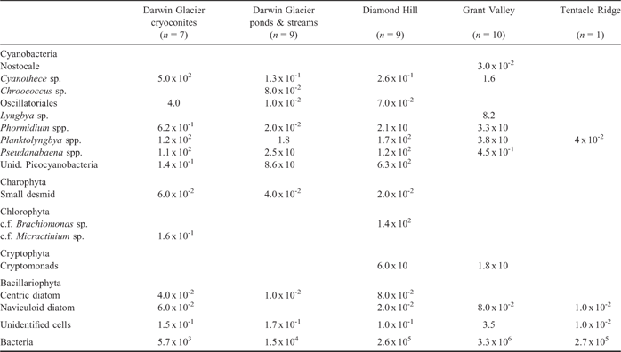
The highest planktonic bacteria concentrations (Table V) were recorded in Grant Valley Ponds (3.3 x 10⁵ cells.ml-1), followed by Diamond Hill and Tentacle Ridge ponds (∼ 2.6 x 10⁵ cells.ml-1). Bacteria numbers found in Roadend snow and ice were similar (1.3–1.6 x 10⁴ cells.ml-1), and similar to the maximum found in the Darwin Glacier ponds (1.5 x 10⁴ cells.ml-1). The greatest contribution of cyanobacteria to the total bacteria count is in the Diamond Hill ponds, but this is still small at < 0.5%.
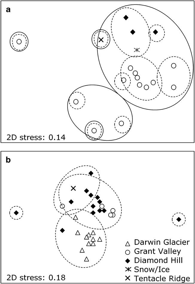
Analysis of the bacterial ARISA data for 17 water samples from the 2009 sampling event (only) identified a total of 552 distinct ARISA fragment lengths (AFL, i.e. peaks). When AFL were totalled across locations, the highest diversity and average AFL per sample was observed in the Grant Valley samples (520 and 90, respectively, n = 13). This was markedly higher than Diamond Hill, Roadend, and Tentacle Ridge (between 30–40 AFL). Two-dimensional multidimensional scaling (MDS) ordination of the AFL from the 17 samples showed a clustering of samples around the Roadend snow sample, indicating similar bacterial assemblages, with only a single pond in the Grant Valley (LH11) being a significant outlier (Fig. 6a). Notably, there was no correlation between the number of bacterial AFL and bacterial cell concentrations (data not shown).
Two-dimensional non-metric multidimensional scaling ordination (stress=0.19) based on Bray-Curtis similarities of ARISA fingerprints of a. bacterial communities in water samples from various Darwin water features sampled in January 2009 (no supraglacial ponds were sampled in 2009, and the points enclosed by solid line cluster at 30% similarity, points enclosed by dashed line cluster at 20% similarity), and b. cyanobacterial communities in sediment and microbial mat samples from various water bodies sampled in both December 2007 and January 2009 (all supraglacial ponds were cryoconites, and points enclosed by dashed line cluster at 25% similarity).
Microbial mats and sediments
Microbial mats were better developed in the terrestrial ponds than in the supraglacial systems, where distinct mats were never seen. Brown/green/grey mats were visible in Diamond Hill ponds, with dessicated mat often surrounding ponds which had experienced a degree of water volume loss. Mats in the Grant Valley ponds were thinner (< 1 mm) and discontinuous, usually grey-pink in colour and tended to accumulate in depressions in the pond floor. These thin mats were dominated by oscillatoriacean cyanobacteria. The fine sediment at the margin and below the ice layer of LH5 in the Grant Valley was the only sediment in which where Naviculoid diatoms were noted in high numbers. Although, mats were not visible on the sediments in cryoconites, or in the larger supraglacial ponds, microscopic analysis of the sediment identified abundant Cyanothece in the cryoconites.
HPLC analysis indicated the presence of chl a in all mat and sediment samples, and chl a concentrations were highest and most variable in the ponds of the Grant Valley (0.8–15.3 μg.cm-2, mean 6.5n = 6). By comparison, chl a in Diamond Hill terrestrial ponds ranged from 0.04–5.07 μg.cm-2 (mean 1.8n = 22) and that of the cryoconites from 0.10–0.93 μg.g-1, (mean 0.29n = 12). Note that sediments from the cryoconites had to be collected using a suction tube and therefore these data have been expressed per gram of sediment, rather than per cm2 of mat.
Chlorophyll b was detected in all samples, but chl c was largely absent. This supports the microscopy data that showed a virtual absence of diatoms, and is further confirmed by the absence of other indicative diatom pigments such as fucoxanthin and diadinoxanthin. The ubiquitous presence of chlorophyte algae was supported by chl b, lutein and zeaxanthin in most extracts. With the tendency for the dominant cyanobacteria and algae to be shared, ratios of pigments across habitat types tended to be rather similar, and no distinct clusters could be identified on the basis of pigment composition. We noted that scytonemin, a cyanobacterial sheath pigment usually associated with screening from excess irradiance was present in almost all extracts from all habitat types.
Bacterial ARISA identified a total of 583 distinct AFL in the benthic samples. When AFL were totalled across locations, the highest diversity and average AFL per sample was observed in the Diamond Hill samples (472 and 93, respectively, n = 15). This was followed by the Darwin (319, 67, n = 10), Grant Valley (260, 72, n = 6) and Tentacle Ridge (113, n = 1). The cyanobacterial ARISA data contained a total of 176 distinct AFL and the average number of AFL per sample was 36. There were several prominent patterns in the two-dimensional MDS ordination. For both the bacterial and cyanobacterial MDS analysis (shown for cyanobacteria in Fig. 6b) all cryoconite samples formed a homogeneous cluster that was clearly separate from the other samples. With the exception of two samples from Diamond Hill, all other samples clustered loosely together.
Metazoa
A total of 10 species of invertebrates were identified in samples of microbial mat from the ponds (see Table VI). These included six species of rotifer, the most common of which was Philodina antarctica Murray, which occurred both in the Diamond Hill region and Grant Valley. Less common species, including Philodina gregaria Murray, Habotrocha cf constricta (Dujardin), Adineta vaga (Davis), and a further, unidentified Adineta species with a narrow head, were only observed in samples from the Diamond Hill area. A further species, Philodina alata Murray, was also present in samples from Grant Valley Philodina antarctica was the only rotifer species recorded from the ice-based, supraglacial ponds on the Darwin Glacier.
Metazoan species observed in ponds of the Darwin region.

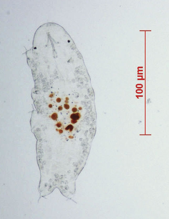
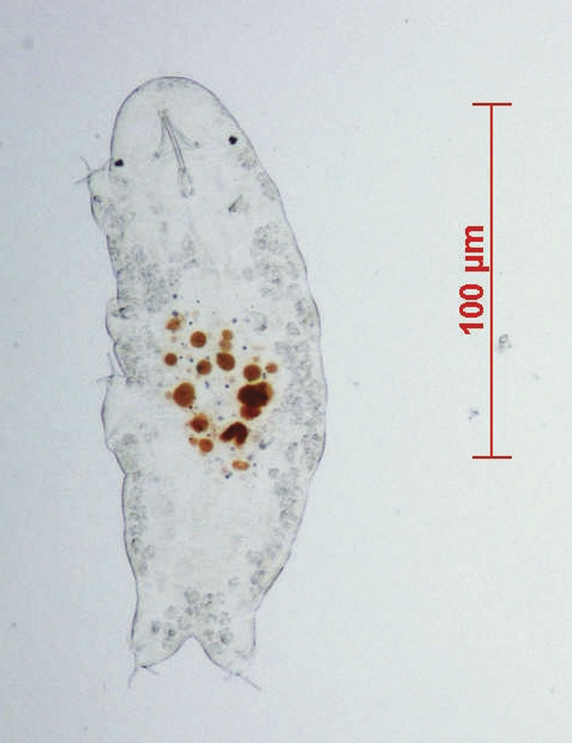
Two tardigrade species were observed, and were present in most ponds in the Diamond Hill area and Grant Valley. The more common species was Acutuncus antarctica (Richter) (Fig. 7), a species known from throughout Antarctica (Dastych Reference Dastych1991). The other species was from the genus Diphascon, which is also well represented in Antarctica (Pilato & Binda Reference Pilato and Binda1999). This species could not be positively identified, but it was morphometrically similar or identical to D. dastychi (Pilato & Binda), which was originally described from further north on the Victoria Land coastline (Pilato & Binda Reference Pilato and Binda1999).
Photomicrograph of tardigrade species: Acutuncus antarcticus from LH8 pond in the Grant Valley.
Only a single species of nematode was observed: Plectus frigophilus Kiryanova, an Antarctic endemic recorded from ice-free areas from around the East Antarctic coastline. The body length (1.61 mmn = 2) separated these animals from the other commonly-occurring member of the genus in East Antarctic ice-free areas, the distinctly shorter Plectus murrayi Yeates. Plectus frigophilus was observed in samples from both rock and ice-based ponds.
The final animal observed was probably a platyhelminth that was approximately 500 μm in length. This species was only recorded from DHL pond in the Diamond Hill region, and was observed to predate on Philodina gregaria. While the taxonomy of this species is unknown, it was different to platyhelminthes recorded from the McMurdo Dry Valleys and elsewhere in Antarctica (J. Gibson unpublished observations). Further samples of this animal are required to confirm its identity.
Discussion
The Darwin Glacier region contains a range of meltwater features, from supraglacial cryoconites to rock based ponds occupying an altitude range from near sea level to 1000 m. The region includes systems that were very close in composition to snow and glacial ice, as well as others where the water quality has been significant altered by evaporation or freeze concentration and biogeochemical processes. All supported biota, which comprised bacteria, eukaryotic algae (though rarely diatoms) and a small number of metazoans, the overall biomass and diversity of which was rather low.
The water bodies sampled are largely at low elevations, but because of the presence of the Ross Ice Shelf, they are effectively inland, being over 200 km from the nearest open seawater. The water features of this region demonstrate many of the characteristics previously noted for inland drainage systems of the Dry Valleys, including high nitrate and DON concentrations (even in snow and ice) and a lack of N-fixing bacteria (e.g. Vincent & Howard-Williams Reference Vincent and Howard-Williams1994).
The aquatic biota of the Darwin Glacier region had a reduced biodiversity compared to that recorded at similar altitudes in the larger McMurdo Sound region to the north. The diversity and biomass of cyanobacteria and diatoms in ponds of the McMurdo Ice Shelf at 78°S was much higher than that reported here, with benthic chl a concentrations of > 30 μg cm-2 and multiple morphotypes of cyanobacteria (Hawes et al. Reference Hawes, Howard-Williams and Pridmore1993, Sutherland Reference Sutherland2009). A picture is beginning to emerge of unexpectedly low diatom abundance and diversity at some inland sites in Antarctica (e.g. Broady Reference Broady1989, Wagner et al. Reference Wagner, Cremer, Hultzsch, Gore and Melles2004). Compared to diatoms, the taxonomy of cyanobacteria is notoriously difficult but the low diversity at the Darwin region is also apparent in groups with well-defined species. For example, while six species of nematode have been recorded in the McMurdo Sound region (Andrassy Reference Andrassy1998), only Plectus frigophilus was recorded in the Darwin Glacier region. This species has been recorded from lake and pond samples from throughout East Antarctica (Andrassy Reference Andrassy1998, Andrassy & Gibson Reference Andrassy and Gibson2007). Of those species that typically inhabit lakes and ponds of the McMurdo Sound region, the genus Eudorylaimus, which occurs widely in East Antarctica (Andrassy Reference Andrassy2008), was absent from Darwin Glacier samples.
Most of the other metazoan species observed at the Darwin Glacier region have been reported previously from East Antarctica, and more particularly from the Victoria Land coast (e.g. Andrassy Reference Andrassy1998, Dartnall Reference Dartnall2000, Adams et al. Reference Adams, Bardgett, Ayres, Wall, Aislabie, Bamforth, Bargagli, Cary, Cavacini, Connell, Convey, Fell, Frati, Hogg, Newsham, O’donnell, Russell, Seppelt and Stevens2006). Philodina antarctica was most abundant species here and is well known from the McMurdo Sound region as well as many ice-free areas of East Antarctica (Dartnall Reference Dartnall2000, Gibson unpublished data). Of the two tardigrade species observed, Acutuncus antarcticus occurs in ice-free areas throughout Antarctica in both moss and pond communities. The genus Diphascon is also widespread in Antarctica. The exceptions to the general picture of a depauperate fauna were the unexpected presence of the rotifers Encentrum sp. and Adineta sp., and the probable platyhelminth, which have not previously been reported from Victoria Land.
The ponds of the Darwin region appear to fall naturally into three distinct groupings, as defined by their physical setting and geochemistry, and to some degree, their biological structure and composition:
i) Terrestrial rock-based ponds, isolated from each other and usually fed by melt from a local snow bank, which may or may not still be present. Such ponds display a range of salinities, depending on their evaporative history, neutral pH and have the most developed microbial mat communities.
ii) Ponds in ice-cored terrain, close to a glacier system, often apparently linked by surface or subterranean meltwater flow and typically with dilute water chemistry. Such pond have thin, but visible, microbial mats.
iii) Supraglacial meltwaters including isolated cryoconites, and larger interconnected open ponds and streams on the surface of the glacier. Such meltwaters have a extremely dilute chemistry having had little or no opportunity to react with soils and salts of the ice-free land surface. Microbial mats were not visible.
The biogeochemical linkages and characteristics which shape and define the three principal habitat types are further discussed below.
Terrestrial ponds
The rock-based, terrestrial ponds of the Darwin region share some similarity with other inland pond systems in that a large range of salinities are shown, stratification is evident in some cases and although predominantly Na-Cl chemistry, the nitrate concentrations is relatively high; high enough to behave as a major ion. High NO3 in inland meltwater ponds occurs throughout the Victoria Valley (Webster et al. Reference Webster, Brown and Vincent1994, Healy et al. Reference Healy, Webster-Brown, Brown and Lane2006), and further south at Pyramid Trough and has also been reported previously for the Darwin region (Vincent & Howard-Williams Reference Vincent and Howard-Williams1994, Timperley Reference Timperley1997). Nitrate-bearing salts such as nitratine are clearly a readily available, immediate source of NO3 to these ponds (likewise salts such as thenardite and gypsum are an immediate source of SO4). Stable isotope data show a heavier oxygen isotopic signature than for ponds more directly derived from ice or snowmelt, due to the loss of the lighter isotope during periods of evaporation. The oxygen isotopic ratio may also be influenced by dissolution of oxygen-bearing mineral salts in the soils, which would be enriched in the heavier isotope.
The fully terrestrial ponds are dependent on snow rather than ice melt to replenish water lost by ablation and evaporation. This balance is a dynamic one, and many ponds on the Diamond Hill Peninsula (on the south side of Lake Wilson) that were water-filled when previously visited by the authors (JWB & IH) in January 1993, were completely dried out when revisited in December 2007. Their position in 2007 was only evident in the shading of the rocks, salts in the soil and dessicated remnants of microbial mats. This suggests this region has cooled (overall) over the last 15 years. The terrestrial ponds appear to have been the most responsive to the recent changes in climatic conditions and are perhaps best thought of as ephemeral ecosystems. The tritium data confirm both a snowmelt origin for this water, and also a relatively recent age. Using data for tritium in Antarctic snow from Fourre et al. (Reference Fourre, Dapoigny, Baumier, Petit and Jouzel2006), which identifies a peak in snow tritium in 1966 of 1000 TU, the snow which fed terrestrial ponds such as the evaporated, saline DHS pond fell < 20 yrs ago.
These are also the ponds showing the highest nutrient concentrations, greatest biological diversity (albeit still low) and the most obvious microbial mats. The apparent ephemeral nature of these snow-dependent systems may in part be responsible for the relatively low diversity and biomass in these ponds. Nitrogen-fixing genera such as Nostoc and Calothrix were absent from the mats and phytoplankton in the Darwin region, a trend also noted by Vincent & Howard-Williams (Reference Vincent and Howard-Williams1994). This is in stark contrast to the well-characterized ponds of the East and West Antarctica where these species are abundant (Jungblut et al. Reference Jungblut, Hawes, Mountfort, Hitzfeld, Dietrich, Burns and Neilan2005, Taton et al. Reference Taton, Grubisic, Balthasart, Hodgson, Laybourn-Parry and Wilmotte2006). These ponds contain high NO3 concentrations and extremely low phosphates levels (Table III), creating conditions that favour non-nitrogen fixing species.
Diatoms were present only in very low concentrations, a trend also observed by Vincent & Howard-Williams (Reference Vincent and Howard-Williams1994) in this region and by others in remote Antarctic sites (e.g. Broady Reference Broady1989). Vincent & Howard-Williams (Reference Vincent and Howard-Williams1994) suggested that diatoms may be less well adapted to survive the hasher environmental extremes of this region and/or not as well suited to long-range wind dispersal as cyanobacteria.
The bacterial ARISA data indicates diverse bacterial communities within these ponds. Bacterial densities were similar to those found in lakes in the Taylor Valley (Takacs & Priscu Reference Takacs and Priscu1998). Further phylogenetic work is underway to explore whether species in these ponds are similar to those found in other Antarctic aquatic systems.
Ice-cored terrain ponds
Ponds in the ice-cored terrain of the Grant Valley (LH2–10) also appear transitory, but for different reasons compared to the rock-based, terrestrial ponds. In the ice-cored terrain, glacier ice provides an additional source of water to that from snowmelt, and there is evidence of dynamic, short term changes in water levels, and subsurface connections between ponds. This suggests less stable hydrological conditions, consistent with a dynamic underlying glacial ice layer.
These ponds generally have a lower salinity than terrestrial ponds, and a more variable pH range. Major ion chemistry again tends toward Na-Cl-HCO3 or Na-HCO3 chemistry (Fig. 3). The reduced role of Cl is a function of their more dilute nature, and derived (at least partly) from glacial ice rather than recent snow fall. Nutrient concentrations in these ponds were largely similar to the concentrations in snow and ice. Tritium and stable isotope data indicate a mixed snow and glacial ice origin for such ponds, and only limited isotopic exchange with mineral salts. Notably LH16, a snow sample from the ice surface of Lake Hendy itself, had elevated major ions and nutrients and a heavier δ18O ratio than other snow and ice in the region. This snow sample may have been affected by sublimation, or by the incorporation of windblown salt, soil and biological debris that accumulate on the surface of large frozen lake features such as Lake Hendy.
Although no high salinity ponds were sampled in this group, it is not improbable that pockets of saline brine may exist in the base of some ponds, even those predominantly frozen at the time of sampling, as liquid brine can persist at the base of the pond depression under such conditions (e.g. Schmidt et al. Reference Schmidt, Moskal, de Mora, Howard-Williams and Vincent1991, Webster et al. Reference Webster, Brown and Vincent1994, Hawes et al. Reference Hawes, Howard-Williams, Schwarz and Downes1997, Healy et al. Reference Healy, Webster-Brown, Brown and Lane2006, Wait et al. Reference Wait, Webster-Brown, Brown, Healy and Hawes2006).
Cyanobacteria also dominated the phytoplankton and microbial mat communities of these systems and with the exception of a small Nostocale fragment, nitrogen-fixers were again absent. Diatoms were in extremely low abundance in all the phytoplankton and mats of all ponds with the exception of LH5 where naviculoid diatoms were present in high concentrations These cells appeared healthy with intact chloroplasts. This “pond” was an anomalous sample in that the feature contained no water, but only a frozen thin ice layer (c. 5 cm thick), which had slightly lifted away from the fine sediment in the base of the pond. The reason for the presence of diatoms in only this pond remains unknown, but these data do suggest that they can survive in these regions and indicates that other factors may limit their abundance.
Supraglacial ponds
The supraglacial ponds were the most dilute pond systems, with a similar chemical composition to the glacial ice from which they are derived. Tritium and stable isotopes support an almost exclusive ice melt origin, with little contribution from recent snowfall. No open cryoconites were observed, and it appears that they may remain almost permanently ice-covered at this latitude. Certainly, the very low tritium values indicate little contribution from surface snowmelt, suggesting very limited contact with snow on the glacier surface. Their chemistry is Na-HCO3 dominated, although NO3 concentrations are comparable to those of other ions, as in the snow and ice of the glacier itself. High DO and pH testify to active photosynthetic processes at the time of sampling (December 2007).
Although bacterial abundance is low (similar to that of the snow and ice) the phytoplankton data and ARISA analyses show that high microbial diversity in both the sediment and overlying water of cryoconites. Previous studies of Antarctic cryoconites in the Dry Valley regions have shown close similarities between microbial assemblages within the cryoconites and nearby aquatic habitats (e.g. Christner & Kvitko Reference Christner and Kvitko2003, Fountain et al. Reference Fountain, Tranter and Nylen2004, Foreman et al. Reference Foreman, Sattler, Mikucki, Porazinska and Priscu2006). Our microscopic observations and ARISA data indicates that a portion of the cyanobacteria and bacteria within the sediment is distinctively different from the ice-cored terrain ponds and terrestrial ponds. The Darwin Region experiences fewer days above freezing than the Dry Valley region (Howard-Williams et al. Reference Howard-Williams, Hawes and Gordon2010) and it is plausible that these cryoconites have been closed to the atmosphere for longer than the 2–11 years suggested for the cryoconites studies in the Taylor Valley (Fountain et al. Reference Fountain, Tranter and Nylen2004). Under isolated and unique chemical conditions it is probable that distinct communities have developed, and survive in these specialized environments.
The cyanobacterial assemblages also differed from those reported in the Dry Valley cryoconites (Mueller et al. Reference Mueller, Vincent, Pollard and Fritsen2001, Christner & Kvitko Reference Christner and Kvitko2003, Foreman et al. Reference Foreman, Sattler, Mikucki, Porazinska and Priscu2006), in that N-fixing cyanobacteria were absent and a large (> 20 μm) Cyanothece sp. was the most abundant species. To our knowledge this species has not previously been reported from cryoconites in Antarctica. This species was also observed in low concentrations in the ice-cored terrain ponds and terrestrial ponds of the Darwin region. Only two species of metazoan were recorded in these ice-based ponds; the rotifer Philodina antarctica and the nematode Plectus frigophilus. Populations in the cryoconite holes and larger ice-based lakes have probably been maintained through aquatic connectivity during melt, or through constant recruitment (to the open larger pond and stream systems) through propagule transport through wind transport from nearby rock-based ponds and lakes.
Conclusions
The substrate of the pond (terrestrial rock, ice-cored moraine or supraglacial) proved to be a major driver of pond biogeochemistry, rather than altitude, pond size or apparent climate conditions. All ponds showed the NO3-N enrichment observed in other inland drainage systems of Victoria Land, and were significantly elevated in DON, but very low in P. Pond chemistries were either predominantly Na-Cl (terrestrial) or Na-HCO3 (ice-core terrain and supraglacial). The phytoplankton communities and microbial mats did not include nitrogen-fixing cyanobacteria and had a generally low abundance of diatoms. Molecular analysis highlighted distinct differences in the sediment/mat prokaryotic community structure between cryoconites and other water body types, but major similarities between terrestrial ponds up to 50 km apart. This may be related to the relatively short life of many terrestrial ponds. Wind-dispersion of particulate nutrients and dried biological material might be an efficient mechanism for seeding meltwater ponds all over the region. Of the 11 species of metazoan identified most were rotifers, followed by tardigrades, a single nematode and a possible playthelminth.
Acknowledgements
This research is funded by the Foundation for Research Science and Technology of New Zealand, under contract CO1X0306. The authors would like to acknowledge the logistic support of Antarctica New Zealand and to thank another regular participants of the K081 event; Drs Clive Howard-Williams and Brian Sorrell for their support. We would also like to acknowledge field events; KO64, KO56 and KO72 for contributing to our water sample collection, Rachel Skews for major ion analysis, Dr Charlie Lee (University of Waikato) for assistance with ARISA data analysis, Daniel List and Janet Adamson (Cawthron Institute) for technical help, and Chris Cunningham and Mike Crump from Christchurch and Hamilton NIWA laboratories respectively for nutrient and pigment analysis.