

Introduction
In the summer of 2011, I was sitting in the office of Professor Suzuki Kazuyoshi of the National Museum of Nature and Science in Tokyo, admiring a space that looked like a cabinet of technological wonders. As we talked, Professor Suzuki pulled out object after object, ducking behind a pile of old books and emerging with a flint, which was carved so ingeniously that it perfectly fit all the miniscule curves of one's hand, or suddenly leaning forward to produce a piece of baleen, said to have been used for making spring mechanisms during the Tokugawa period.Footnote 1 At a certain point he fetched a round wooden box, which he did not seem to handle as a valuable object, saying “I have plenty of those.” “Open it,” he said. “Do you notice something strange here?” I shifted my gaze to the object he was holding and saw a compass. Looking closer, I noticed to my great astonishment that the directions were written counterclockwise, placing east where I expected to see west and vice versa. The seemingly nonsensical design surprised me: why would somebody create an orientation device that contradicts the very basis of our understanding of directions?
One possible answer could be that these “reverse compasses” represented a uniquely Japanese way of dealing with space. And one Japanese scholar indeed arrived at this conclusion, referring to rather dubious origins myths, and coining the term wajishaku – Japanese compasses (Namba Reference Namba1966, 45).Footnote 2 The fact that English-language scholarship is mostly silent on the topic of reverse compasses may support this assertion as well.
Yet there are manifold reasons not to accept this conclusion. First, there is a high likelihood that reverse compasses were not invented in Japan. The authors of most of the primary sources discussed in this essay identified themselves with schools of surveying that claimed Chinese, Portuguese, or Dutch origins.Footnote 3 This is not to say that these sources provide hard evidence that reverse compasses were imported, since foreign origin was assigned rather loosely. “Portuguese” and “Dutch” in Tokugawa discourse were often conflated,Footnote 4 while the only apparent difference between “Chinese” and “Western” methods of surveying was the mode of dividing the circleFootnote 5 (Suzuki and Yoshikazu Reference Suzuki and Yoshikazu2009, 42). Still, there is a real possibility that reverse compasses originated outside of Japan and hence cannot represent a uniquely Japanese perception of space.
Second, reverse compasses could not be representative of Japanese perception of space because they were not the norm in Tokugawa Japan either. The sources describe those devices as having a “structure [that] is the opposite of usual, with the [directions] written to the left and not to the right,” or as having a “reverse” order (Murai [Reference Murai Masahiro1733] Reference Murai Masahiro1978; Hosoi Reference Hosoi1717; Shimada Reference Shimada1725; Okumura Reference Okumura1838 and Reference Okumura1839; Yoshimura [Reference Yoshimura and Shōichi1800] Reference Yoshimura and Shōichi1929–1931; Torikai Reference Torikai1770; and Hattori Reference Hattori1810). Some authors like Murai Masahiro ([Reference Murai Masahiro1733] Reference Murai Masahiro1978) even specifically advised that in order to use the compass, one needed to “ignore the convention” and look at the compass in an “unusual” way. The compasses’ unusual characteristic also found its way into the very names used to describe them. The standard term for a compass in Japanese is jishaku (磁石), meaning “magnet stone”; colloquially, compasses were often referred to simply as “needles” – hari/shin (針). Consequently, reverse compasses were referred to as “compasses turning in the opposite direction” (坂巡り磁石), “reverse needles” (逆針), or “backward needles” (裏針).
Finally, even if somebody in Japan independently invented a reverse compass, such devices were not unique to Japan. Several early modern European surveying manuals, such as those by William Leybourne Reference Leybourne1674, or George Adams [Reference Adams1790] Reference Adams1803, mentioned in passing that many instruments have their degrees and directions inversed. The physical science collection at the National Museum of American History holds numerous reverse compasses, most of which belonged to the famous eighteenth-century American polymath, David Rittenhouse.Footnote 6 The Deutsches Museum in Munich displays a nineteenth-century surveyor's compass with a reverse dial, which was used by miners.Footnote 7 Some modern ships and planes, too, rely on navigational instruments with reverse dials.
The special thing about the Japanese case, thus, was not the presence of reverse compasses, but their use beyond narrow professional circles. Similar to their American and European counterparts, Japanese surveyors used reverse compasses for their measurements. And indeed, several museums in Japan possess exquisite brass reverse compasses that belonged to surveyors’ toolkits.Footnote 8 However, according to Professor Suzuki (personal communication), Japanese collections also have numerous simpler, wooden compasses. Given the fact that the majority of Tokugawa-period wooden artifacts were lost to frequent fires and woodworms, such a collection suggests that the actual number of reverse compasses was rather large – well beyond the number required by professional surveyors alone. Moreover, we find frequent references to reverse compasses in amateur surveying guides, such as Hosoi Kōtaku's Reference Hosoi1717 Hiden chiiki zuho taizen (Complete and Illustrated Private Instructions about Land Surveying), Mao Tokiharu's Reference Mao Tokiharu1722 Kikubuntōshū (Collected Materials on Land Surveying), Murai Masahiro's famous Reference Murai Masahiro1733 Ryōchi shinan (Introduction to Land Surveying), and others.
Why was this type of compass known beyond professional circles in Tokugawa Japan? How did people know how to make sense of the apparently nonsensical, “backward” dial? What advantage did these compasses provide for Tokugawa users? And was there something beyond practicality that can explain the choice of a “backward” compass over a regular one?
In order to answer some of these questions I bring in a methodological tool that has not been a standard one in the historians’ toolkit – cognitive science. The questions of what advantage these compasses provided and why a large number of people were familiar with them can be answered by analyzing the relationships among the practices, needs, and historical circumstances of the Tokugawa period. Such a methodology, however, proves to be limited when it comes to drawing conclusions concerning individual reasoning and understanding. Sources that discuss in detail the reasoning of artisans, for example, are extremely rare. Partially this is because artisans seldom had the opportunity or motivation to write down their thoughts. More importantly, however, is the fact that artisans’ work is often habitual, and hence even artisans themselves cannot always answer why they are doing what they do. This is where cognitive science becomes handy. It allows us to search the sources we do have for footprints of cognitive processes, creating a link between social practices, material environment, and individual perceptions.
The specific approach I adopt as a methodological tool is distributed cognition theory. Developed by Edwin Hutchins in the 1990s, this approach maintains that individual cognition is not contained in one's brain but rather distributed in the society and embedded in one's material environment (Hutchins Reference Hutchins1995 and Reference Hutchins2005; Clark Reference Clark2008). The theory suggests that rather than computing all available information each moment anew, humans conserve cognitive effort by delegating information processing to other people and tools, and relying on existing categories. In other words, humans form their perceptions by building on information passed down from previous generations; by listening to instructions they receive from other people, reading signs, and using computational instruments; and by inferring from their previous experience. Consequently, each act of individual cognition is determined by a historically specific environment.
There are two main reasons why this approach is particularly suitable to the analysis of reverse compasses. First is the fact that Hutchins's case study in the book that introduced the distributed cognition approach focused on navigation and spatial perception (Hutchins Reference Hutchins1995). In addition to conducting an ethnographic observation of ship operations, Hutchins also pointed out the role of culture-specific assumptions and material culture in forming one's perception of space.Footnote 9 Although he did not discuss reverse compasses per se, his analysis is particularly fitting for making connections between historical context, material environment, and individual cognition in the study of compass orientation.
The second reason that makes the distributed cognition approach compelling is its similarity to methodologies already employed by historians of science and technology. In particular, this approach is compatible with the notions of tacit knowledge (Polanyi [Reference Polanyi1958] Reference Polanyi2015; Collins Reference Collins1974 and Reference Collins and Schatzki2001; Turner Reference Turner1994 and Reference Turner2013) and material epistemology (Baird Reference Baird2004; Daston Reference Daston2000, Reference Daston2004, and Reference Daston2008; Mahoney “Reading a Machine”). Like the concept of tacit knowledge, the distributed cognition approach maintains that acts of knowing rely on numerous inferences from one's own past experiences, which extend well beyond those sources of information that are explicitly acknowledged.Footnote 10 Like material epistemology, distributed cognition theory takes artifacts to be a crystallization of human experiences, and hence repositories of cultural cues that could be potentially interpreted by other humans as sources of knowledge.Footnote 11 Finally, distributed cognition theory confirms the findings of scholars who explore technological design and claim that our sense of “convenience” and “usability” mostly relies on our pre-existing habits and the “common sense” we develop based on our lived experience (Norman Reference Norman1988, Reference Norman1992, and Reference Norman1993).Footnote 12 The advantage of the distributed cognition approach is that it corroborates the insights gained through both the framework of tacit knowledge and material epistemology by using cognitive psychological methods that are largely inaccessible to historians. Namely, it has the capacity to back up historical claims that cannot be supported by explicit statements in primary sources. Furthermore, it widens the extent to which human experience of the world could be seen as socially constructed from the realm of practice and interpretation to the very core of human cognition.
Using the approaches described above to analyze available sources from the Tokugawa period, this essay explores what made reverse compasses in Tokugawa Japan not only useful to a narrow circle of professions, but also compelling and comprehensible to a broader audience. In the first part of this essay I focus on the practicality of reverse compasses. I argue that reverse compasses allowed users to conserve cognitive effort while assessing their targets, and that this relatively minor advantage was particularly appealing for mariners relying on the coastal sailing practices characteristic of the mid-to-late Tokugawa period. The second half of the essay investigates the factors that made reverse compasses “visible” in the popular discourses of the Tokugawa period. I claim that the popularity of reverse compasses was fueled by a flourishing publishing industry that profited from popular interest in “professional secrets” and from the vicarious thrill of the potentially dangerous situations in which reverse compasses were used. Furthermore, I show that reverse compasses were relatively easy for even nonprofessionals to understand because the heuristics required for their reading were already familiar to Tokugawa Japanese from mapping conventions and timekeeping practices.
Reverse Compasses and Cognition
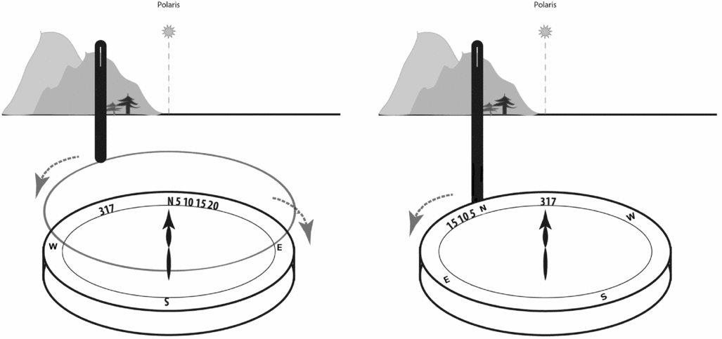
Why would one need a compass showing east as west? (See figures 1, 2, 3, 5, 11 below.) There are two important hints in the construction of the compass. First, at the bottom of the compass there is a notch, indicating that it was mounted on something stable rather than being held in the hand. Second, it is not only the east and the west that are reversed: the whole compass rose is written in a counterclockwise rather than clockwise order. The explanation is that the needle does not indicate north but rather the direction of one's target, and in order to use it one does not look at the general direction the needle is pointing to but rather at the needle's precise location on the dial itself.
In position 1 a ship with a regular compass moves north. Position 2 shows the compass when the ship turns. When using a reverse compass, as shown in position 3, the tip of the needle will indicate the direction the ship is going.

Left: surveying with a regular compass and a separate alidade. Right: surveying with a reverse compass where the alidade is attached.

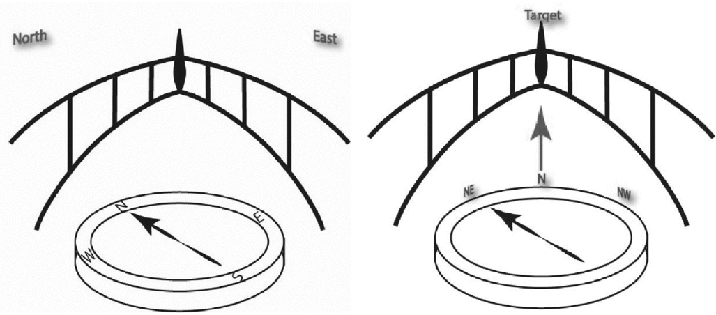
Left: space perception with a regular compass. Right: space perception with a reverse compass.

Many readers may find this explanation rather unsatisfactory, especially if they have not had the experience of working with reverse compasses. The idea that the needle does not point north reads as an affront to common sense. This is because even though the above explanation was technically correct, it lacked two important components – visualization and context. So let us discuss several examples of the use of reverse compasses in situ.
The first example comes from the world of navigation, describing the way these compasses were used on Tokugawa period merchant boats.Footnote 13 Imagine that we are on a ship. A conventional compass is stable on the bridge (hence the notch mentioned above), with the north on the dial aligned with the prow.Footnote 14 In this position, the needle, pointing to the magnetic north will also point to the north indicated on the compass dial (see figure 1, position 1). Our ship then turns northeast. The compass needle will still be pointing to the magnetic north, but since the compass is affixed to the deck, the needle will now rest on the compass dial between north and west.Footnote 15 The ship is going northeast, but the needle is between N and W (figure 1, position 2). However, if we reverse the directions on the compass dial, the needle will be resting between N and E, indicating the actual direction we are traveling (figure 1, position 3).
Another example shows similar use of reverse compasses, this time for the purpose of surveying (Murai [Reference Murai Masahiro1733] Reference Murai Masahiro1978). When determining the position of a landmark with a regular compass (or theodolite), a surveyor would first align the compass needle with the north, then rotate the alidades (or sighting devices) until he can see the landmark through the slot, and then calculate the angle between the two (fig. 2, left). With a reverse compass, however, the surveyor would only need to find the target through the alidade and then glance at the tip of the compass needle to find the angle. The act is shorter and simpler because alidade is attached to the compass at the N point, so that rotating the alidade results in the rotation of N; when the degrees are written in a reverse order, the rotation of N effectively places the degree indicating the angle of the target under the compass needle (fig. 2, right).
Space Perception with Reverse Compasses
In addition to requiring a different sequence of actions, reverse compasses also inform our cognition of space in a manner different from regular compasses. On a regular compass, the needle points to the assumed North Pole, which lay well beyond the compass dial and not visible to the person operating the compass (fig. 3, left).Footnote 16 In order to take the assumed North Pole into account, a regular compass requires one to adopt a bird-eye view, and imagine looking at oneself from above, seeing one's own movement on a map-like plane or globe-like sphere (Hutchins Reference Hutchins1995, 62). In other words, regular compasses inform our perception of space as a stable geographic reality that is external to us. Reverse compasses, on the other hand, make us see space as it is experienced at eye level, from our own point of view. The reverse compass and the user form one unit – whenever the user turns, the compass indicates their direction; whatever target the user decides to look at, the compass follows.Footnote 17 One does not look at the reality that exists beyond the dial, only at the tip of the needle indicating one's own actions. For those using reverse compasses, wherever they turn, they are still going straight ahead (fig. 3, right).Footnote 18
Because compasses inform, rather than represent, one's perception of space, users can choose which perception is the most fitting for their activities. It is thus not surprising to find that many reverse compasses also had a regular dial. By switching one's gaze from one set of letters to another, the user could also switch from seeing the space from a bird's-eye perspective to a personal point of view and back again. It is, of course possible to create a mental vision of one's space, and even to defy the suggestion of the particular compass one is using – but choosing an appropriate compass makes this task easier.
Advantage of Using Reverse Compasses – Cognitive Perspective
This brings us to the main reason behind using a reverse compass – in some situations they make life easier. First of all, using reverse rather than regular compasses simplifies measurement, reducing the possibility of error as well as the calculation time. With regular compasses, a navigator must find two points (the north and the target), then note the intersection between the devices used to make the sightings (the compass and the alidade), and then make a calculation from the two data points. Calculation errors can creep in at each one of these three steps, and even a slightest one can seriously distort the data. With the reverse compasses, however, the navigator only makes one step – to sight the target with the alidade. Since the alidade is attached to the dial, once the sighting has been made the reverse compass needle automatically provides the sought value.Footnote 19 The navigator does not need to make any further calculations or adjustments; the needed value is there, at the tip of the compass needle.Footnote 20 As one Tokugawa-period author put it, reverse compasses, unlike humans, “never mix up the degrees” (Kaichū hidokei 1820).
In addition, reverse compasses allow one to concentrate on measurement by temporarily ignoring everything in the surrounding geographical space. With regular compasses the calculations require finding intersections between several points of reference, which necessitates maintaining awareness of these external factors. Reverse compasses only require one to be aware of the tip of the needle, without exerting mental energy on other, potentially confusing, factors.
In sum, reverse compasses allow one to conserve cognitive effort. Eliminating a couple of steps from the calculation process and blocking off possible cognitive “noise” may not sound like much in normal conditions. After all, most compasses aren't reversed, suggesting that their users are doing just fine without a reversal. However, there are some situations where all one's attention is needed – sometimes to assure the precision of the measurement and sometimes to save one's life. As we shall see in the following section, the particular historical circumstances of the Tokugawa period in Japan made the advantages offered by reverse compasses especially appealing.
Reverse Compasses in Tokugawa Japan
One of the crucial factors shaping the use of reverse compasses in Tokugawa Japan was the lack of experience with sea voyages. Although contrary to the popular notion, Japan was never “secluded” during the Tokugawa period (Kazui Reference Kazui1982; Toby Reference Toby1984; Hellyer Reference Hellyer2009), the fact remains that citizens of Japan could not travel to other countries.Footnote 21 Those who decided to leave were not allowed to ever return. Since ships never had the goal of reaching a foreign destination, there was no need to endure the hardship and the dangers of the open sea.
On the other hand, domestic commerce was mainly conducted by water. Japan being an archipelago already necessitated that at least some goods be transported by sea. The impassible mountain ranges that run through the islands made boats an even more reasonable choice. As commercial activities grew exponentially in the seventeenth and eighteenth centuries, Japanese sailors developed two well-established routes that circumnavigated the islands – one clockwise and the other counter-clockwise. Given the abundance of manpower and the relatively low cost of sending out boats for short trips, merchant boats during the Tokugawa period were rather small, albeit numerous (Frumer Reference Frumer2018).
One side effect of this situation was that Tokugawa sailors mostly relied on coastal sailing. Hopping from port to port along their route, they found their way by identifying terrestrial landmarks during the day and observing the position of the stars during the night. Whatever mistakes they made were soon corrected by identifying the next familiar landmark.
However, these practices did not work when the conditions were not favorable. Cloudy skies and stormy weather made it difficult not only to see the stars and spot the landmarks but also to simply step outside the cabin. With no outside information available, Tokugawa sailors would be left to sail blind until conditions improved. It was in such situations that they resorted to the use of reverse compasses, which they also called “darkness needles,” or yami hari (闇針) (Yoshimura [Reference Yoshimura and Shōichi1800] Reference Yoshimura and Shōichi1929–1931). Regular compasses could be of some help but, as one observer reported, “even with a favorable wind, the compass does not just show the direction . . . rather, the tip of the needle moves to the right and to the left,” and during a storm the needle wobbles incessantly (Bikei [Reference Bikei and Shōichi1841] Reference Bikei and Shōichi1929–1931). In such conditions the multiple-step calculations required by a regular compass meant more possible mistakes, and any mistake required that everything be calculated all over again. Reverse compasses were much easier. As mentioned above, the characteristic quality of reverse compasses was that they formed one unit with the user. In the case of the boat, they were positioned stable on the boat with the north aligning exactly with the prow. Consequently, in order to sail in a desired direction, all that the sailors needed to do was to steer the boat so that the tip of the needle rested on the target direction (Kaichū hidokei 1820). Even when nobody was looking, the needle continuously pointed out the direction of the movement, never confusing the directions regardless of how many turns the ship took (Hosoi Reference Hosoi1717; Mao Reference Mao Tokiharu1722). And even if the compass needle moved away because of the trembling of the boat, one could still keep the boat on its route by rotating the ship until the tip of the needle returned to its desired place. More importantly, one could do all this “without even looking outside!” (Hosoi Reference Hosoi1717).
There was also a much more serious danger. The Japanese archipelago is often subjected not only to ordinary rains and storms but also to lethal typhoons. Having only a vague sense of how strong a storm they faced was going to be, Tokugawa sailors hoped for the best, knowing all the time that their shallow boats could not withstand a typhoon. Their fears were exacerbated by the policies of the Tokugawa shogunate, which dictated that those who left Japan could never return. This meant that even if a boat survived the storm by finding safe haven in foreign lands, those on board gave up the hope of ever seeing home again. Those castaways who were returned – by the Russians, for example – were treated with suspicion, interrogated at length, and sometimes confined for the rest of their lives.Footnote 22 Staying in foreign lands forever was a scary prospect in another sense – the lands north of Japan were perceived in the Tokugawa period as bizarre and barbaric, and Japanese sailors saw themselves as culturally superior to the northern savages. The possibility of being swept away by a typhoon was therefore the ultimate fear for Tokugawa mariners.
When the sailors found themselves in the middle of a raging typhoon, their problem was not only that they did not know where to go, but also that they completely lost control of the ship. Swept by the winds into the middle of the sea (or the ocean) and drifting for days with ever-changing winds, they could easily lose their way home (Yoshimura [Reference Yoshimura and Shōichi1800] Reference Bikei and Shōichi1929–1931). And without knowing where they were, and which direction home was, a regular compass would be no help.
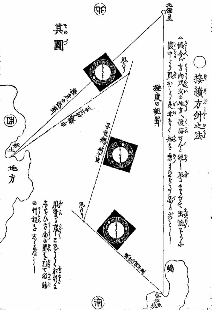
It was in anticipation of such situations that Tokugawa mariners used reverse compasses: not to direct the ship, but to note where the ship was being taken (Hosoi Reference Hosoi1717; Murai [Reference Murai Masahiro1733] Reference Murai Masahiro1978; Bikei [Reference Bikei and Shōichi1841] Reference Bikei and Shōichi1929–1931; Kaichū hidokei 1820; Yoshimura [Reference Yoshimura and Shōichi1800] Reference Yoshimura and Shōichi1929–1931). By recording every turn that the boat took and estimating how much time the boat sailed in any given direction, sailors could gain a very rough approximation of their location (Murai [Reference Murai Masahiro1733] Reference Murai Masahiro1978) (see fig. 4). According to one author, “no matter how much you drift away, if you keep watching [the reverse compass] from the moment you leave the harbor until you reach another place, you [won't lose a thing]. . . . even if you drift away for several hundred thousand ri 里,Footnote 23 there is no way you would not be able to return back to Japan” (Yoshimura [Reference Yoshimura and Shōichi1800] Reference Yoshimura and Shōichi1929–1931). Today, this method may seem far from precise, but for Tokugawa sailors drifting into a sea, it was the best shot at trying to find the route back home.
The image uses the bird's-eye view map with stable directions in order to show the use of reverse compasses. The lines indicate the ship's route, while the turning points indicate where the wind changed. The white round dot indicating the north target on the compass is always aligned with the direction of the ship's movement, while the index needle, although stable from the bird's-eye view, is pointing out the ship's direction with its every turn. (From Yoshimura's Outline of Compass and Useful Things to Remember in Sailing, Reference Yoshimura and Shōichi1800).

Making Reverse Compasses Visible
An additional question, however, is why do we know that Tokugawa period sailors on merchant boats used reverse compasses and how did they do so? After all, sailors’ skills were mostly passed on through apprenticeship; sailors only rarely left detailed documentation of their practices and when they did, they passed that information on only to those involved in the trade.
Here again, we can point to a particular constellation of historical circumstances that made reverse compasses “visible” in Tokugawa Japan – albeit in the realm of publishing and popular literature. There were very few completely illiterate people in Tokugawa Japan, especially in the eighteenth and nineteenth centuries. The levels of literacy, of course, varied a lot, and only a few could claim to be proficient in what was considered to be the highest level – freely composing prose in Classical Chinese. Yet almost everybody could read at least the basic kana alphabet and enjoy fiction (Kornicki 1998, 272–4). Thus, for example, when a Russian navy captain was held hostage in a remote northern location in Japan in the early nineteenth century, he was amazed by the fact that his prison guards spent their time reading books (Golovnin Reference Golovnin1894, 132). People of every stratum of society consumed written and printed materials – they bought books at book shops, borrowed them from traveling libraries, and copied by hand the ones that were difficult to come by. Such extensive readership was assisted by the fact that books could be printed in quantity using woodblock technology. Woodblock printing was cost-effective and allowed printed material to include pictures, maps, tables, and any other form of illustration in addition to text.
One of the most popular – and profitable to publishers – genres of books was “how to” manuals. These manuals promised readers quick insight into the “tricks” and “shortcuts” of specialized professions – such as flower arrangement, the keeping of horses, Noh theater performance, martial arts, poetry, mathematics, medicine, or land surveying – while sparing them the extensive training required to actually learn the profession. Publishers often described such books using the Japanese term hiden (秘伝), which may be translated as “secret transmission,” enticing readers with the promise of insights into knowledge otherwise available to the select few. It did not matter that these “secret” books were, in fact, purposefully written for the mass market, became bestsellers, and were reprinted numerous times – readers nevertheless enjoyed the sense of being invited into an exclusive club.
One of the best examples is Murai Masahiro's Reference Murai Masahiro1733 Ryōchi shinan (Introduction to Surveying). In explaining the motivation behind writing his bestseller, Murai stated:
In surveying, there is a distinction between theory and practice.Footnote 24 Theory is what you study daily in the privacy of your room until you fully fathom it. Practice is when you go outside into the fields and gradually learn by trial. . . . Even though we say that theory and practice are intertwined, the learning of the art of measurement does not come from books.Footnote 25 If you do not meet [professionals] and learn things orally [from them] you will not be able to understand it. There are many things that [professionals] know very well, but I went ahead and put them into a book. (Murai [Reference Murai Masahiro1733] Reference Murai Masahiro1978; author's translation)
This may sound paradoxical: there are things that cannot be learned from books, and here is a book about them. But the promise of quick insight into knowledge that “would [otherwise] take half a lifetime to learn on your own” (Yoshimura [Reference Yoshimura and Shōichi1800] Reference Yoshimura and Shōichi1929–1931) had great appeal for amateur readers.
Surveying was one of the hottest topics for popular guides. With government management of the taxation system and a growing number of large-scale infrastructure projects, surveying began to bloom as a profession in the late seventeenth century and had developed into a major industry by the early eighteenth (Brown Reference Brown1987). Surveying appealed to general audiences for several reasons. First, it was seen as a step up from mathematics, which was already considered a fashionable hobby in the seventeenth century. Second, it required traveling, which was both a work-related necessity and a favorite leisure activity of Tokugawa Japanese. Thus, for example, the famous surveyor Inō Tadataka (1745-1818) started as an amateur, who learned from the library of popular guides he amassed so that he could survey the lands he passed on his numerous business trips.Footnote 26 The guides were written by professional surveyors, who thought that publishing a popular book would earn them fame and money. Therefore, the information they contained was largely up-to-date on a professional level, even if simplified.
These surveying guides were where the first descriptions of reverse compasses appeared. One such guide even contained a fanciful origin myth that attributed the invention of reverse compasses to a surveyor sent to survey the damage of the Meireki fire that destroyed the city of Edo (Tokyo) in 1657. According to the legend, finding no remaining landmarks to orient himself, the surveyor invented an orientation device that could be operated blind (Namba Reference Namba1966, 45). Although the myth is doubtfully true, it portrays the seventeenth-century perception that reverse compasses were inherently connected to surveying. Surveying guides listed reverse compasses as one of the tools of the trade, usually in a list of all kinds of possible compasses. Unlike other instruments, however, reverse compasses offered not only the excitement of measurement but also the possibility of adventure.
One of the ways surveying guides enticed potential readers was to offer them an adventure. In some cases, the adventure was a spying game. In 1733 Murai Masahiro wrote that reverse compasses were also sometimes called “concealed compasses” (shinobu jishaku 忍磁石). This sort of compass was used, the author wrote, “when you want to assess the land or the geography secretly, without being noticed” (Murai [Reference Murai Masahiro1733] Reference Murai Masahiro1978). About a century later, another famous Japanese surveyor of the Tokugawa period, Ishiguro Yoshinobu, recommended using a reverse compass when one was trying to survey a foreign territory while remaining unnoticed by the locals (Matsuzaki Reference Matsuzaki1979). From the surveyor's point of view, a concealed reverse compass required only minimal bodily movements, and even allowed one to take surveying notes from the comfort of one's palanquin (Torikai Reference Torikai1770). Since the Tokugawa period was characterized by its long-lasting peace and its prohibition of international travel, actual opportunities to survey enemy territory were limited to cases of neighborly disputes or suspected tax fraud. Nevertheless, imagining surreptitious surveying likely offered many readers a sense of adventure.
Another kind of adventure offered by the popular guides was dangerous seafaring. Most of the readers of popular guides had little need to go aboard merchant boats, but the thrill of storms and the danger of becoming a castaway were enough to ignite the imagination. Even territories as near as Morioka and Aomori (both on the main island of Honshu) were considered to have indigenous and bizarre cultures. The northern island of Ezo (present-day Hokkaido) was seen as occupied by savages. And anything beyond that was a mystery. Reading about how mariners could use reverse compasses to find their way home allowed the readers to experience the excitement and the danger of being cast away in a strange and frightening territory, under the pretense of engaging with a “useful” hobby.
Popular surveying and navigations guides were therefore a genre of thrillers. The authors of these guides did everything they could to strike fear into the hearts of their readers before telling them about the “secret” solution to a given narrative's precarious situation. Okumura prefaced his treatise by stating that “[Japan] is surrounded by sea from the four directions. But in spite of the many ships we use in recent years, every year we lose so many lives because people drift away, and valuable things are lost. . . . How can we prevent disasters while sailing?” (Okumura Reference Okumura1838). Bikei offered advice about what to do if “you are taken by the wind, and you are in the middle of the open sea, not knowing where you are” (Bikei [Reference Bikei and Shōichi1841] Reference Bikei and Shōichi1929). And Yoshimura straightforwardly declared: “Let's say you left the port and got into the open sea, the wind changed three times, and you drifted for three days; or the sea is running high, or it rains and the skies are covered by clouds, and it is impossible to measure the angle of the stars. This is how you lose your way back home. If you come to this, you better use the art of the compass. Without that, there is nothing that can save you!” (Yoshimura [Reference Yoshimura and Shōichi1800] 1929–1931).
By the nineteenth century the Japanese public was more and more aware of the world outside of Japan, and scholars began contemplating sea voyages to Europe – like the ones taken by the Dutch who arrived at Dejima. Such scholars began pondering about the rudimentary state of Japanese navigation techniques and sought to learn about Western seafaring practices. But many preferred to start by learning about the existing practices of Japanese mariners. Thus, for example, in the early years of the nineteenth century, the famous economics scholar Honda Toshiaki (1743-1822) went on merchants’ boats in order to learn the art of navigation (Frumer Reference Frumer2018). Owing to the popularity of navigation as a subject, the tools of mariners – especially the “trick” tools such as reverse compasses – became visible to the general public.
Interestingly, the descriptions in the Tokugawa-period guides never went into a lengthy explanation of the rationale behind the reverse compass. Rather, they simply stated the dial was reversed, “the opposite of usual” (Murai [Reference Murai Masahiro1733] Reference Murai Masahiro1978) and then explained the situations in which such compass might be useful. Neither did they resort to the sort of visualization that I offered at the beginning of this article. Even when the guides provided a picture, it was simply a picture of a reverse dial, without any other context. Given that Tokugawa-period books were made by using a woodblock technique, producing images in books was not more difficult than printing text, and most of the manuals were accompanied by numerous pictures. Therefore, we can conclude that the lack of images was not an unfortunate result of technical constraint, but rather of authors’ conscious decisions that those images were not needed. Our task in the next section is to understand why Tokugawa-period readers did not require a lengthy explanation or visualization.
Understanding Reverse Compasses in Tokugawa Japan
Like any other humans attempting to decipher a previously unfamiliar device, Tokugawa Japanese understood reverse compasses by interpreting their structure in light of heuristics they acquired through their lived experience. Unlike a modern-day reader, however, even non-surveyors and non-mariners among the Tokugawa Japanese possessed a cognitive toolkit of cultural knowledge that enabled them to recognize the rationale behind the reversal of compass directions. Relying on their accumulated experience with cultural symbolism, map-making conventions, timekeeping practices, and habits acquired in handling other devices, they could read the potential reversal from the cultural cues embedded in the design of contemporaneous reverse compasses.
Correspondence System
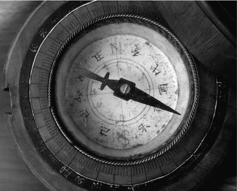
One major factor that facilitated Japanese understanding of reverse compasses was the fact that directions on Tokugawa compasses were indicated using the twelve animal signs (fig. 5). Often mistakenly referred to as “zodiacs,” due to their use for prognostication purposes, the signs have no relation to the stellar constellations on the zodiac belt.Footnote 27 Rather, they derive from ancient Chinese cosmology, according to which there is correspondence between a yearly cycle of birth and decay and other natural phenomena. The twelve animal signs derive from the twelve lunar months and correspond to the twelve hours and the twelve directions. Thus, the darkest month of the winter solstice was associated with midnight and with the north; the month of the summer solstice was associated with noon and the south; the equinoxes corresponded to the times of dawn and dusk, as well as to the east and the west. The twelve signs then became associated with animals – Rat, Ox, Tiger, Rabbit, Dragon, Snake, Horse, Sheep, Monkey, Rooster, Dog, Boar – although the difference between the characters for signs and those used for the actual animals betrays the fact that this association was a later construct.Footnote 28 The Chinese cosmological system surrounding the twelve animal signs was imported to Japan in the eighth century and crystallized into a conventional representation of both hours and directions. Despite the fact that the signs were usually written clockwise, however, there were several practices that allowed for the possibility of using an orientation device with the directions written counterclockwise.
Japanese reverse compass from the early twentieth century. The smaller inner circle of Japanese characters shows the twelve animal signs written in a clockwise manner. The outer circle shows the twelve signs written counterclockwise. N replaces the sign of the Rat (visible on the inner circle), and S replaces the sign of the Horse. Only the north and the south are the same in both circles. (Author's collection)

Maps
One such practice was allowing flexibility of the assumed point of view in maps. Although in ancient Chinese cosmology north was identified with the winter solstice and the midnight hour, there was no assumption that the north, the winter, and the midnight should be placed at the top of the page when these concepts were represented visually. Rather, the bottom of the page represented the assumed position of the viewer (Frumer Reference Frumer2018). Since ancient Chinese map-making was a government-led enterprise, numerous ancient maps assumed that this viewer was the ruler. And since tradition demanded that the ruler sit at the north of the capital city, to protect the citizens from the harmful northern winds, the bottom of state maps represented the assumed viewpoint of the ruler, namely southward.Footnote 29 Accordingly, the latitudes were counted from the North Pole towards the equator, and the first orientation device invented in ancient China was said to point south, as seen in the name it was given – the South Pointing Carriage. In Japan, the southward orientation had lost its primacy by the eighteenth century, because by that time the Japanese had gotten used to Western maps where the north was positioned at the top, and because map making had long ceased to be a prerogative of the state. Nevertheless, cues signaling the primacy of the south still permeated Tokugawa culture. Even in the nineteenth century, Tokugawa astronomers who practiced Western style astronomy sometimes used the traditional word for “latitude” which literally meant “distance from the north pole.”Footnote 30 The words for “guidance” or “introduction” literally meant “pointing south.” And numerous maps still placed the north at the bottom.
What Tokugawa period maps retained from the ancient tradition was the possibility of assuming the users’ point of view.Footnote 31 There were, of course, maps that assumed a bird's-eye view. There were also astronomical diagrams, maps, and celestial globes that necessitated a bird's-eye view of the whole earth. However, there were numerous other maps that assumed the user's perspective. Thus, for example, a map might show the outline of a temple from the main gate, the path through the mountain pass from the entry, a map of a tourist destination from the main road, etc. In these maps, north could be located anywhere on the page as long as the top indicated “straight ahead.” While trying to find their way using such a map, Tokugawa users did not need to physically – or mentally – rotate the map to align with what they saw in front of them. Nor did they need to imagine themselves from above, walking on the map. The map simply told them what they needed to expect when they proceeded forward.
Other maps did not abide by the north-at-the-top rule for practical reasons. Maps were often printed in a size and format determined by the woodblock technology and the medium – such as a book, for example. In this sense, the map of the Japanese archipelago was representative. If one wanted to achieve as much detail as possible and also fit the map onto two adjacent pages of an open book, one had to rotate Japan on its side. When maps of Japan came to include the northern island of Hokkaido in the nineteenth century, the challenge grew, as even an open book could no longer contain all the islands. To solve the problem, some printers added a fold-out page with the map of Hokkaido, which was rotated to a different degree than the main island. In order to read such a map, the reader would look separately at Hokkaido and at the main island of Honshu. Or, if push came to shove, the reader could cut the book and rotate the map to align everything together.Footnote 32
Similar flexibility in assumed point of view was prevalent in painting. Western perspectival painting – as Tokugawa observers noticed – assumed that the viewer would stand a short distance from the hanging picture, looking at it from eye level.Footnote 33 European viewers were so accustomed to assuming this position that Hans Holbein, in his famous work The Ambassadors, surprised his viewers by including a hidden meaning that could only be seen when the painting was viewed from the side. In Tokugawa Japan, however, the painter knew that viewers could look at a painting from different positions and that it would not necessarily be hung on a wall – it could be placed on the floor (as many people did while looking at a painting in a book). There could even be numerous people viewing the same painting at once. Consequently, many paintings included multiple perspectives, sometimes multiple vintage points, and sometimes text written in different directions. It was up to a viewer to find and adopt a desirable point of view, as the painting did not predetermine one (for a variety of maps, see Yonemoto Reference Yonemoto2003, and Wigen et al. Reference Wigen2016)
These practices of mapping and visual representation in paintings provided Tokugawa users with the cognitive preparation needed for reading reverse compasses. Being accustomed to the fact that there was more than one way to orient a map or to view a painting, Tokugawa users were also open to the possibility of having more than one way of using an orientation device. When reading a map oriented towards the north they learned that in order to use it they had to imagine that they were looking at themselves from above. However, using a map that was oriented according to the presumed observer's view taught them another tactic – to take the top of the page to be “straight ahead,” the target, and to imagine oneself moving forward regardless of the turns one has to make. And having had experienced working with maps of different kinds and viewing paintings drawn according to different perspectival approaches, Tokugawa users already knew that the first thing they needed to figure out when encountering an orientation device was to decide which approach was the optimal for the particular situation they were in.
Time Telling
Tokugawa-period surveying and navigation guides also show that readers gained cognitive preparation for deciphering a reverse compass from the world of timekeeping. Indeed, the idiosyncratic practices of the Tokugawa period made the similarities between timekeeping and spatial orientation particularly important. None of the authors, of course, made an explicit statement about the use of timekeeping practices as a cognitive tool. Yet their writings are telling in what they implicitly suggest. Not only did they discuss timekeeping and orientation practices in the same terms, but they also discussed them in immediate proximity.Footnote 34 Seeing this structure in multiple texts, we can conclude that the authors of surveying and navigation guides themselves saw the practices of reading a timepiece and reading a compass as related, and that they wanted to reinforce this conceptual connection for their readers.
In the Tokugawa period, the correlation between hours and directions was obvious. As mentioned above, both hours and directions were referred to by the twelve animal signs, and both derived from the same system of ancient Chinese cosmology. Consequently, the midnight hour was marked by the sign of the Rat (子) and associated with the north; noon was marked as Horse (午) and associated with the south. The hour of dawn, the Rabbit (卯), was associated with the east, and the hour of dusk, Rooster (酉), with the west.
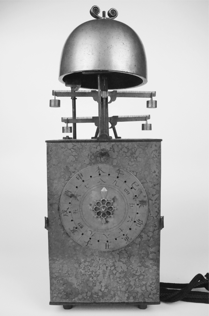
Another peculiarity of the Tokugawa period timekeeping system reinforced the sense that there was no predetermined place for directions on a two-dimensional surface. Unlike our modern system that makes all hours of equal length, Tokugawa society used a system in which hours changed their length with the seasons. Every day was divided into twelve hours – six of light and six of darkness; and since the relative amount of daylight and darkness varied throughout the year, the length of the hours changed accordingly. This meant that when represented on a dial, hours did not necessarily have a predetermined place, but rather moved along the dial. Such an arrangement can clearly be seen in ancient timekeeping technologies such as the clepsydra, the sundial, and incense clocks. However, when in the sixteenth century Europeans imported mechanical clockwork technology to Japan, Japanese artisans invented mechanical designs that maintained similar flexibility. Thus, for example, in some clocks, the midnight hour was placed at the bottom of the clock dial – similar to the north in maps or to circular hour charts (Frumer Reference Frumer2018, 55–6). In other clocks midnight did not have a stable place at all as the whole dial rotated (see fig. 6). Sometimes digits were placed on a movable plane, so that the owner could physically change the length of the hours. And yet another kind of clock replicated the scale of the clepsydra with a vertical rather than circular dial. Consequently, the association between hours and directions did not reinforce an automatic arrangement of left and right, or top and bottom. Quite the opposite, it reinforced the sense that the direction one was looking for could be anywhere.
Tokugawa period clock with a rotating dial and a stable index hand. In the current position of the dial, the “now” that the index hand indicates is just before the hour of the Sheep, which is the next hour after noon. The digit of the noon hour (Horse) is a bit to the right of the top, in a position that today we would define as about four minutes past the hour. (The Seiko Museum Collection)

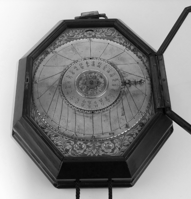
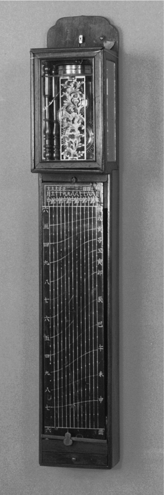
The practices involved in reading mechanical clocks in the Tokugawa period were the same as those required for reading a reverse compass. In particular, some mechanical clock designs relied on the same cognitive actions needed to read a reverse compass – to identify the top of the dial as “right now” (i.e. the value one is seeking) and to look at where the tip of the needle rests instead of the direction it points. In some types of Japanese clocks, the index hand was always stable, pointing upwards, while the dial with hour digits rotated at different speeds during the day and the night. Since the index hand was always in the same position, reading the hour required not locating the position of the hand, but rather looking closely at what lay beneath it. Whatever digit or fraction of the hour was underneath the hand was “now.” The cognitive habit developed by using such clocks was to look underneath the stable, forward-pointing index in order to identify the value one was looking for. Another clock-reading habit similar to that of reading a reverse compass was looking at the tip of the index. On one particular kind of clock (fig. 7), the index hand did rotate, but it also grew and shrank over the course of the year, while the field allocated to each hour was demarcated not by straight lines but by curvy ones that signified the changing length of the hours in different seasons. Consequently, even though the needle was rotating, one could not just look at the general direction it was pointing, since the same degree of inclination could mark one hour in summer but a different hour in winter. In order to read the hour one had to locate the precise place where the tip of the index was resting. Other clocks were not circular at all, but rather structured as a graph, in which one had to spot the exact intersection between seasons and hours in order to know what time it was (see fig. 8). In these clocks too, one had to look at the specific spot where the tip of the index was resting, rather than a standard place or general direction.
A round graph-like clock. The curving lines indicate the hour, and the needle grows and shrinks depending on the season indicated on the central disk. In the current position, the season is past the summer solstice, and the needle is extended all the way to the edge. The tip of the needle rests just past the afternoon hour of the Monkey. However, we can see that during another season, when the index is not as extended, the same angle of the index hand would indicate something closer to the hour of the Rooster, which was the dusk hour that separated daytime and nighttime. And in the dead of the winter, the needle would be barely visible and the same angle would indicate the hour of the Boar, which was a nighttime hour. (For more details on the allocation of seasons and the convention of numbering the hours, see Frumer Reference Frumer2018). (The Seiko Museum Collection)

A graph-like clock. The straight vertical lines on this clock indicate the seasons, and the curved lines indicate the hours. The horizontal bar (at the very bottom of the dial in the picture) moves downward over the course of the day. The knob on the bar would be adjusted according to the season (in the current position, it is two months before the winter solstice). In order to know the time, the owner of this clock would look at the precise spot where the knob is resting, and judge which of the curving lines it is closest to. (The Seiko Museum Collection)

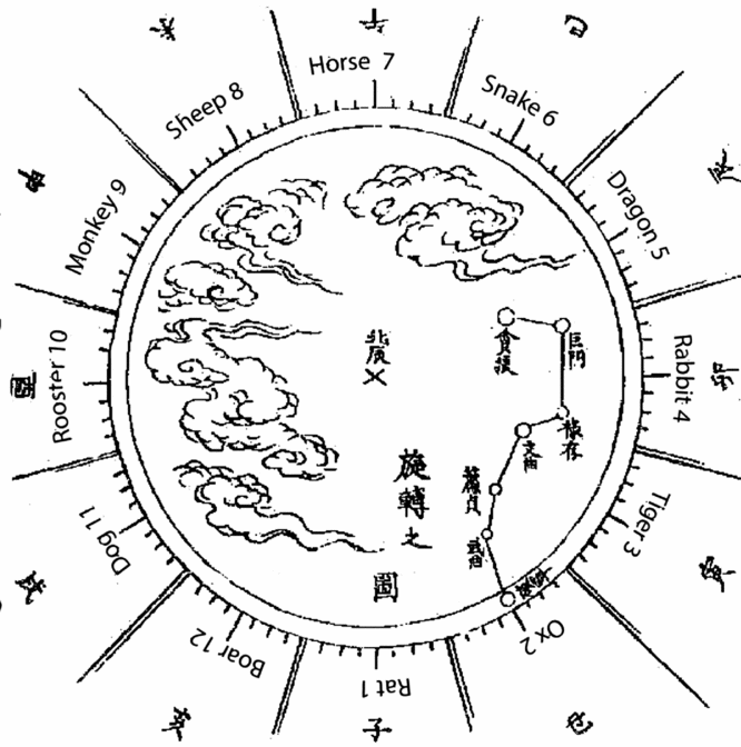
Other timekeeping practices required the reversal of the order of hours. One such practice was the use of so-called “star clocks,” or hoshidokei (星時計). Although during the Edo period mechanical clocks were increasingly popular, people also used non-mechanical timepieces and were still familiar with how to tell time by looking at the stars. In manuals that claimed to provide practical “shortcuts,” non-mechanical modes of timekeeping were an especially popular theme. According to these sources, the apparent rotation of the Big Dipper around the North Star could be seen as a one gigantic clock dial (fig. 9), with the tail of the Big Dipper serving as an index hand, and the seventh star as its tip.Footnote 35 The skies around the North Star could then be mentally divided into twelve sections corresponding to the twelve hours, with the midnight hour (the hour of the Rat) placed at the bottom, directly underneath the North Star (Yoshimura [Reference Yoshimura and Shōichi1800] 1929–1931; Hosoi Reference Hosoi1717; Ishiguro Reference Ishiguro1833). However, since the Big Dipper rotates counterclockwise, in order to read the time off the stars, one had to imagine the skies as a clock dial with the hours written in reverse order.Footnote 36 Even if over the course of the Tokugawa period fewer and fewer people actually needed to use this kind of clock, it was still plausible to look at the skies in such a manner. Moreover, some mechanical clocks with rotating dials imitated the movement of the stars, with leftward-rotating dials on which the digits were arranged in a counterclockwise order. Whether one used mechanical timekeeping devices exclusively, or (more likely) a variety of timekeeping means, this kind of reverse order of the hours was not uncommon. And familiar as they were with this practice, Tokugawa users could see how a similar reversal could make sense in reverse compasses.
The author imagines the northern skies as one giant clock dial with the Big Dipper serving as an index hand. The numbers indicated in the image are the order in which the sequence is recited, starting with the hour of the Rat (midnight). In the image, the tail of the Dipper indicates the hour of the Ox, one hour past midnight. (From Yoshimura's Outline of Compass and Useful Things to Remember in Sailing, Reference Yoshimura and Shōichi1800).

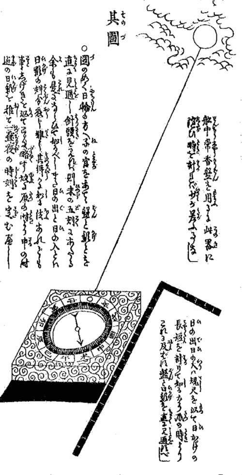
One could even use reverse compasses to tell the time. Measuring time with sundial required one to face directly north, so portable sundials of the Tokugawa period were usually equipped with a compass. However, reverse compasses could be used as timepieces by themselves (fig. 10).Footnote 37 In order to tell time using the reverse compass, one had to align the “North/Midnight” mark on the compass with the sun. Since looking directly at the sun is not particularly advisable, the user verified that “North” was indeed aligned with the sun by making sure that the shadow cast by the compass fell directly behind it (Yoshimura [Reference Yoshimura and Shōichi1800] 1929–1931). When aligned in this manner, the tip of the compass needle, pointing towards magnetic north, rested on the direction that was associated with that hour of the day. However, this only worked if the directions, i.e. the hours, on the dial were reversed.
Similar to the compasses used on a boat, in this reverse compass the round circle indicates the target – in this case the sun. After verifying the compass is properly aligned with its shadow, the owner of the compass would look at the tip of the needle and see that it rests on the hour of the Sheep (past noon). (From Yoshimura's Outline of Compass and Useful Things to Remember in Sailing, Reference Yoshimura and Shōichi1800).

This method of telling time called for a series of practical steps that were strikingly similar to using the reverse compass for orientation. First, it called for treating the “North” mark not as a signifier of magnetic north, but as a signifier of a target: in this case the sun. Second, it required overcoming the association between the passage of time and the movement of the sun, as well as disregarding the “usual” signifier of the passage of time – the shadows cast by trees and mountains. Instead, ignoring everything else, one had to focus on the tip of the needle alone. And finally, of course, one had to reverse the directions/hours on the dial. Consequently, the two practices involving reverse compasses – the reading of time and of directions – required similar ways of looking at both the device and the environment.
Timekeeping practices of the Tokugawa period were representative of a larger set of learned cognitive habits that assisted potential users of reverse compasses in understanding these devices. Timekeeping practices did not necessarily precede the direction-reading practices, since the artisans who designed them likely relied on existing assumptions about how one locates hours and directions. However, each new design – each new practice that required flexibility of spatial perception, the identification of the sought value with “straight ahead,” the looking at the tip of the index, and the reversal of the order of the hours or directions – reinforced the body of knowledge that provided the heuristic basis for reading reverse compasses. Drawing on these heuristics, Tokugawa users could then easily see the rationale for reversing the order of directions, assumed that it was possible to treat the “North” mark simply as a target, and knew how to look at the tip of an index needle instead of in the general direction it pointed.
Conclusion
There are several possible ways to tell the story of Tokugawa-period reverse compasses. One story would explain reverse compasses as a derivative of the particular political and material conditions of their users. In this story, Tokugawa period sailors who circumnavigated the archipelago in shallow boats were particularly vulnerable to the possibility of being swept away into the ocean and becoming castaways, forbidden from ever returning home. Trained to sail their boats by identifying visible landmarks on shore, these sailors did not have sophisticated navigational methods and instruments, and thus embraced cheap and simple reverse compasses that offered them at least a faint hope of finding a way home.
Another story would focus on the surprising visibility of a piece of technology, the actual use of which was restricted to a very narrow, and far from socially prestigious group of people. This story would explain the popularization of reverse compasses by referring to the state of Tokugawa period media. Flourishing print culture, exceptionally high literacy rates, the proliferation of travel-related literature, and particularly the popularity of the “secret knowledge” genre that allowed readers the thrill of professional endeavor without long training or actual danger: all these together positioned reverse compasses as a good topic to write about.
And there is yet another story – the story of the very ability to recognize the rationale and the mode of use of reverse compasses. In this story, Tokugawa Japanese could read reverse compasses because they were already familiar with the spatial perception and cognitive practices the devices required. Owing to the prevailing flexibility in map orientation and perspective reading, the Tokugawa Japanese were ready to choose among different possibilities of space perceptions. And having had experience with timekeeping devices – whether mechanical or not – they already had the habit of looking at the tip of the index hand, identifying it with the target, and perceiving the device as showing one's own perspective. In other words, Tokugawa Japanese had a cognitive toolkit, which they accumulated in the course of their lives, which enabled them to read a device that in other cultural circumstances might be deemed incomprehensible.
The implications of the last story go well beyond one obscure instrument and touch upon the relationship between human cognition and the objects we use. Reverse compasses show that artifacts inform our very cognition. They do not determine how we perceive our surroundings, but they channel our perceptions, making one way of seeing the world easier than another. Seeing how Tokugawa Japanese deciphered reversed compasses also illuminates the way that our own approach to new objects is shaped by our previous experience with other artifacts. The bodily and cognitive habits we develop as we use a variety of artifacts in the course of our lives form a toolkit of potential approaches we draw upon when we encounter something new or unusual. And since the artifacts we use are products of the culture in which we live, this means that not only our practices but also our very cognition is socially constructed.
Afterword: Cultural Knowledge and Intuitive Understanding
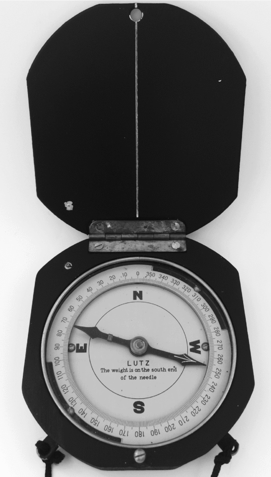
Reverse compass dials did not disappear from the world in the twentieth century. In fact, once I started working on Tokugawa reverse compasses, I began seeing reverse dials everywhere – in field orientation kits and surveying equipment, on navigation dials on ships and in small planes, and many other places (fig. 11). But these reverse dials are like a secret hiding in a plain view – they are not understood by people who have not been trained to work with them and therefore remain invisible.
“Lutz” reverse compass, twentieth century. This compass was made in Japan and sold to American instrument-distributing companies. (Author's collection)

Identifying the factors that allowed Tokugawa Japanese to more easily read reverse compasses also suggests why modern-day users may initially perceive these objects as counterintuitive and requiring a step-by-step explanation. The practices that allowed Tokugawa Japanese to develop the cognitive habits necessary for reading reverse compasses are foreign to the modern world, including Japan. The assumptions about ways of viewing space, which we develop by using our maps and clocks, are contrary to the approaches required for operating a reverse compass.
Today, we have a firm association between a specific hour and a specific place on a two-dimensional circle: even if there are no numbers on the dial, we know that a small index hand pointing ninety degrees to the right indicates three o'clock. Since the position of the digits is stable, it does not matter how close or how far they are located from the center – the index hand points in the general direction of the hour, not to a specific spot on the dial. Knowing that this is how we perceive the relationship between hours and directions, we can ask our interlocutors to look at their “three o'clock” and assume that most of them will understand what we mean. But this also means that in our tacit understanding of how pointers work there is only one option – looking in the general direction it is pointing.
Modern day maps, too, inform us that the bird's-eye view is the only possible option. Most of our maps are north-oriented (and those that aren't throw us off). These maps require us to imagine seeing ourselves from above, moving within a stable space. People who are deemed to be poor at map-reading – i.e. who have difficulty adopting a bird's-eye view – are often looked down upon as lacking a basic skill. We even place a normative value to such perception of space, equating the phrase “bird's-eye view” with a broad, well informed, and objective perspective – the opposite of the detested “tunnel vision.” In short, our life experiences guide us to assume a stable layout of space and to default to a bird's-eye perspective on it.
We deem reverse compasses counterintuitive because we lack the kind of life experience that could have prepared us for reading and understanding them. The common sense that we developed through experience with other direction-related objects channels us to the cognitive approach demanded by a regular compass. We have not seen that there could be other options and thus cannot imagine them.
Recently, however, a one notable exception seems to have emerged. In my experience explaining the rationale and the advantages of the reverse compass, I noticed that after my interlocutors understood the concept, they often remarked that the perception required to use a reverse compass was similar to that required by modern-day mobile navigation applications. Like with the reverse compasses, the user and the application he or she uses form a single unit – wherever the user turns, so does the phone displaying the map. The default setting of the app interface is the personal point of view, so that no matter how many turns the user takes and which direction the user is headed, the arrow still shows “straight forward.” Navigation application relieves the user of complicated cognitive tasks by concealing potentially confusing information in the environment, allowing the user to focus on the targeted path. In short, looking at navigation instructions on one's smartphone requires a cognitive approach similar to that required by reverse compasses. Perhaps, as navigation applications become more and more popular, they will also prepare modern-day humans for reading reverse compasses.