The pages of the Mixtec screenfolds—created in Oaxaca, Mexico, from the fourteenth to sixteenth centuries—are painted with hundreds of place signs. Only a handful of these signs have been linked to specific locations on the ground (see Byland and Pohl Reference Byland and Pohl1994; Jansen Reference Jansen and Bricker1992:25–27; König Reference König1979; Smith Reference Smith1973a:55–82). One challenge for interpreting Mixtec place signs has been uncertainty about the geographic scales involved. Do the Mixtec screenfolds tell pan-Mexican stories, stretching from Teotihuacan to Chichen Itza (Jansen and Pérez Reference Jansen and Jiménez2007; Taube Reference Taube, Carrasco, Jones and Sessions2000:314)? Or are their narratives much more local, focused on specific regions within Oaxaca (Byland and Pohl Reference Byland and Pohl1994; Pohl Reference Pohl, Hendon and Joyce2004; Smith Reference Smith1973a)?
This essay addresses the scale of Mixtec screenfold geography through reference to Yanhuitlan's 1544–1547 inquisitorial proceedings. These colonial, alphabetic records are filled with place names. They allow us to understand how sacred locations surrounding Yanhuitlan were connected in practice, through the visits of nobles and religious specialists. In addition, it has long been recognized that six of the “idols” said to be worshipped by the nobles of Yanhuitlan appear together, personified, in sequential pages of the Codex Vienna (Codex Vindobonensis Mexicanus I 1974) and Codex Nuttall (Codex Zouche-Nuttall 1987). These painted deities are, in turn, linked to specific sacred locations: they stand or sit on different place signs. In other words, screenfolds and court records provide parallel lists of divinities, and potentially parallel lists of sacred locations as well.
In the following pages, I propose identifications for seven place signs which appear in the Codex Vienna and Codex Nuttall. Core evidence from the Mixtec screenfolds and Yanhuitlan proceedings is supplemented with the findings of a FAMSI-funded study of colonial and independence-era land documents (Hamann Reference Hamann2008a), data from archaeological surveys (Byland and Pohl Reference Byland and Pohl1994; Kowalewski et al. Reference Kowalewski, Balkansky, Walsh, Pluckhahn, Chamblee, Rodríguez, Espinoza and Smith2009; Spores Reference Spores1972), and on-the-ground reconnaissance. By considering the sequential relations of place signs painted in the Mixtec screenfolds, the spatial relations of geographic features visible today (features whose names and recent history are recorded in archival documents), and the sacred relations revealed by the actions of nobles and religious specialists in the Yanhuitlan idolatry investigation, strong proposals for the identification of particular place signs can be made.
In turn, these identifications have broader implications for understanding colonial transformations of space. Over the course of the sixteenth century, sprawling pre-Hispanic polities were atomized. The land documents their leaders then created mapped out visions of political space far more circumscribed than those we see in pre-Hispanic books, and indeed in alphabetic documents—such as the Yanhuitlan idolatry investigation—that date to the first half of the sixteenth century. Pre-Hispanic images of the landscape, like pre-Hispanic genealogical records, present complex regional chains of connectedness. Single documents record the lineage histories of a number of different royal families, and traverse complicated paths across the landscape. In contrast, after the second half of the sixteenth century, Mixtec documents tend to focus on single towns, single lineages, and landscape boundaries viewed from a central point. This, as I argue in the final pages, suggests that different types of research methods are needed for studying landscape representations created before and after the middle of the sixteenth century.
LANDSCAPE, DIVINITY, AND IDOLATRY IN YANHUITLAN
From 1544 to 1547, an inquisitorial investigation was conducted against three indigenous nobles from the Oaxacan town of Yanhuitlan: cacique Don Domingo and gobernadores Don Francisco and Don Juan. These men were accused of performing sacrifices, worshipping non-Christian gods, and encouraging their subjects to do the same (Cervantes Blengio Reference Cervantes Blengio and Airoldi1999; Hamann Reference Hamann2011; Jiménez Moreno and Mateos Higuera Reference Jiménez Moreno and Higuera1940; León Zavala Reference León Zavala1996; Pérez Ortiz Reference Pérez Ortiz2003; Piazza Reference Piazza2005; Sepúlveda y Herrera Reference Sepúlveda y Herrera1999). Witness testimonies describe a number of places where “idolatrous” acts were supposedly performed, and provide the names of six Mixtec deities: Guacusachi, Gauguisacuhu, Quaquxio, Quacuxiq, Siquiui, and Quequiyo. The nobles of Yanhuitlan were said to worship these divinities in the form of stone “idols.”
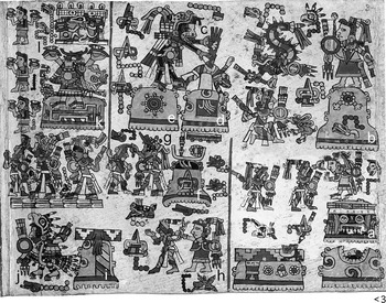
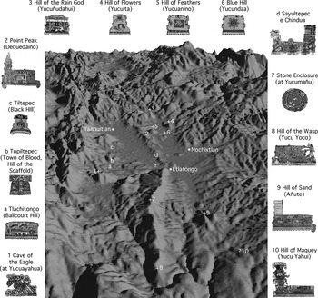
The importance of these six names was noted in one of the first publications to discuss the Yanhuitlan trial: Wigberto Jiménez Moreno and Salvador Mateos Higuera's El Códice de Yanhuitlán (Reference Jiménez Moreno and Higuera1940:48). In 1982, Maarten Jansen translated the names of these deities as Lord 7 Wind, Lord 7 Motion, Lady 11 Serpent, Lord 10 Lizard, Lord 11 Crocodile, and Lady 9 Reed. He linked these names to images of deities with the same names that appear in the Codex Nuttall and Codex Vienna (Jansen Reference Jansen1982:284–285). Significantly, on both Codex Nuttall page 3 and Codex Vienna pages 4 to 1, these gods and goddesses are associated with a set of related place signs (Figures 1 and 3). Jansen proposed identifications for two of the place signs on Codex Nuttall 3: Yucuñudahui (Hill of the Rain God) and Yucuita (Hill of the Flower, or Flowers). Both hills are located quite close to each other in the northern Nochixtlan Valley (Jansen Reference Jansen1982:269; Pohl Reference Pohl, Hendon and Joyce2004:227–229) (Figures 4 and 5). More recently, John Pohl (Reference Pohl, Hendon and Joyce2004) has proposed identifications for a number of other place signs that appear on Codex Nuttall 3 and Codex Vienna 4 to 1.Footnote 1 He offers several possible correlations for Hill of the Jewel, including Sayucunda, located just to the southwest of Yucuita. He identifies Hill of the Ballcourt as Tlachitongo (about 12 km southwest of Yucuita), since the name of that town in Mixtec is Yucu Yuhua (Hill of the Ballcourt). He identifies Insect Hill and Spiderweb as Sayultepec (Yucu Tiyuq, Hill of the Fly) and Chindua (Spiderweb), both a few kilometers northeast of Tlachitongo.Footnote 2 And he identifies Black Hill as Tiltepec (Yucu Tnoo), about 6 km north of Tlachitongo. Again, all of these places are in the northern Nochixtlan Valley (Figures 4 and 5).
Codex Nuttall page 3. The reading order begins in the lower right-hand corner and moves from right to left. Details include: (a) Hill of the Rain God, (b) Hill of Flowers, (c) Lord 7 Motion, (d) Hill of Feathers, (e) Blue Hill, (f) Black Hill, (g) Lord 7 Wind, (h) Lady 8 Deer, (i) Town of Blood, (j) Lord 7 Wind, (k) Ballcourt Hill, and (l) name glyphs for Lady 11 Serpent and Lord 11 Crocodile.

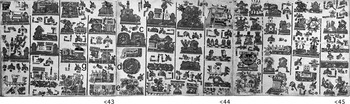
Codex Vienna pages 45 to 43. The reading order begins on page 45 and moves from right to left. Details include: (a) Hill of the Rain God, (b) Ballcourt Hill, (c) Blue Hill and Hill of Feathers, (d) Stone Enclosure, (e) Cave of the Eagle, (f) Town of Blood, Hill of the Scaffold, and (g) Black Hill.

Codex Vienna pages and 4 to 1. The reading order begins on page 4 and moves from right to left. Details include: (a) Blue Hill, (b) Hill of Feathers, (c) Lord 7 Motion, (d) Stone Enclosure and Lady 9 Reed, (e) Cave of the Eagle, (f) Ballcourt Hill, (g) Lady 11 Serpent, (h) Lord 10 Lizard, (i) Town of Blood, Hill of the Scaffold, (j) Lord 7 Wind, (k) Lady 8 Deer, (l) Black Hill, (m) Lord 7 Wind, (n) Point Peak, (o) Hill of the Fly and Spiderweb, (p) Hill of the Wasp, (q) Hill of Sand, and (r) Hill of Maguey.

Places in the Nochixtlan Valley with identified place signs from the Codex Nuttall and Codex Vienna. Settlements are labeled with letters; geographic features with numbers (with a plus sign placed over the highest point of identified hills). The locations of Yanhuitlan, Etlatongo, and Nochixtlan have been added for orientation. The view is from the south, toward the north.

Location of Nochixtlan in Mesoamerica (top) and map of the Nochixtlan Valley (bottom).

As part of his 2004 essay, Pohl makes some important comments on the methods he used to link place signs in the Mixtec screenfolds to geographic locations on the ground. Many place names are quite common. For example, there are dozens of Yucu Dzaa (Hills of the Bird) in Oaxaca. Because of this, it is risky to take an isolated place sign in a Mixtec screenfold and claim that it correlates to a singular place on the ground. Instead, stronger arguments can be made by linking groups of place signs shown together in the screenfolds to groups of geographic features found together on the ground. This is the method Pohl used for making new identifications of sites in the northern Nochixtlan Valley (Pohl Reference Pohl, Hendon and Joyce2004:230–232, 235–235; see also Jansen Reference Jansen and Bricker1992:25). Pohl does recognize that some of the signs he discusses could be linked to places with the same names found elsewhere in the Mixteca. However, since there are a number of places in the northern Nochixtlan Valley that can be correlated to a number of signs shown together in the Codex Nuttall and the Codex Vienna, these other possibilities, located outside the Nochixtlan Valley, are less convincing.
My own essay follows the basic method proposed by Pohl: studying not single places in isolation, but groups of interconnected locations. As with previous studies by Jansen and Pohl, my identifications focus on three sections of the Mixtec screenfolds: above all Codex Nuttall page 3 and Codex Vienna 4 to 1, but also Codex Vienna 45–43 (Figures 1, 2, and 3). Page 3 of the Codex Nuttall appears at the beginning of that document, and is part of an origins story about the foundation of the first Mixtec polities (Anders et al. Reference Anders, Jansen and Jiménez1994). Ten place signs are shown on page 3, and gods and goddesses stand and fight at many of them. Pages 45 to 43 of the Codex Vienna occur near the beginning of that screenfold, and pages 4 to 1 are at its very conclusion (the Codex Vienna has 52 pages, numbered in reverse order). The text as a whole deals with the creation of the world, the ordering of its geography, and the placement of gods and goddesses in their proper locations (Anders et al. Reference Anders, Jansen and Jiménez1992; Furst Reference Furst1978; Jansen Reference Jansen1982). Pages 45 to 43 show dozens of the places newly-revealed when Lord 9 Wind lifted up waters from the primordial ocean to create the sky. In contrast, pages 4 to 1 depict a mature and ordered landscape. Each page contains four large place signs, and named deities stand on most of these 16 signs. Because six of the gods and goddesses shown on Codex Nuttall 3 and Codex Vienna 4 to 1 are named in the Yanhuitlan documents, I propose that many of the place signs associated with these painted deities are themselves locations named by Yanhuitlan witnesses. Together, overlapping information from pre-Hispanic screenfolds and colonial litigation provides the foundation for a new understanding of sacred geography in the Nochixtlan Valley.Footnote 3
Briefly, the following pages identify (1) “Hill of the Jewel” as Yucundaa or “Blue Hill,” just southwest of Yucuita; (2) “Hill of Feathers” as Yucuanino, just west of Yucuita; (3) “Cave of the Eagle” as the Peña del Águila in the mountain of Yucuayahua, just south of Tlatayapan and Nejapilla; (4) “Town of Blood, Hill of the Scaffold” as a place near Topiltepec; (5) “Stone Enclosure” as the Cueva del Señor in the mountain of Yucumañu; (6) “Point Peak” as Dequedaiño, just north of Yucucui; and (7) “Hill of Maguey” as Yucu Yahui, between Jaltepec and Santa Inés Zaragoza. Taken together, these seven locations form an itinerary of basically contiguous sites, beginning west of Yucuita in the northern Nochixtlan Valley and ending southeast of Jaltepec in the southern Nochixtlan Valley. This full itinerary is depicted across pages 4 to 1 of the Codex Vienna, and traces an initially clockwise path across the Nochixtlan Valley. A smaller segment of this itinerary appears on page 3 of the Codex Nuttall, and traces a counter-clockwise route.
WEST OF YUCUITA, SOUTH OF YUCUÑUDAHUI: YUCUNDAA AND YUCUANINO
In 1982, Maarten Jansen suggested that the Hill of Flowers and Hill of the Rain God which appear together on Codex Nuttall 3 correspond to adjacent Yucuita and Yucuñudahui in the northern Nochixtlan Valley (Jansen Reference Jansen1982:268–269) (Figures 1a, 1b, 4, and 5). Yucuita was a town subject to Yanhuitlan in the sixteenth century, and is repeatedly named as an “idolatrous” location by witnesses in the Yanhuitlan documents. It was the site of a periodic market where sacrificial offerings could be purchased, and nearby were two caves in which sacrifices were performed. For example, in October 1544, Juan de Naveda testified that “in the town of Suchitepeque [the Nahuatl name for Yucuita] which is subject to Yanhuitlan, they have, where they hold the market, a cave which they believe is sacred.”Footnote 4 Archaeological investigations in the 1970s and 1980s documented both of the caves mentioned by Yanhuitlan witnesses, which are located in a low hill (Totohuada) just north of the community of Yucuita (Plunkett Reference Plunkett1983:176; Spores Reference Spores1972:119–120). Curiously, although the representation of Hill of Flowers on Codex Nuttall 3 is associated with two named deities (Lord 7 Serpent and Lady 6 Eagle), neither of these beings are referenced in the Yanhuitlan documents.
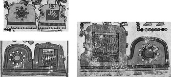
However, immediately to the left of Hill of Flowers on Codex Nuttall 3 there appears a god who is indeed named in the Yanhuitlan documents: Lord 7 Motion (Jansen Reference Jansen1982: 284). On both Codex Nuttall 3 and Codex Vienna 4, Lord 7 Motion is associated with a pair of hills, hills that also appear together on Codex Vienna 44 (Figure 6; see also Figures 1c-f, 2a-c, and 3c). One hill is always ornamented with a red rectangle, on which (or in which) is painted a bundle of feathers. On Codex Vienna 4, the feathers take the form of a cape. The other hill is ornamented with a round jewel sign. On Codex Vienna 4, the hill itself is actually painted blue. In his 2004 essay, John Pohl offered a number of possible identifications for this location. One of the options he suggests is a hilltop archaeological site just to the southwest of Yucuita (Pohl Reference Pohl, Hendon and Joyce2004:230–231). According to survey work conducted by Ronald Spores in the late 1960s, and to maps created by Mexico's Instituto Nacional de Estadística y Geografía (INEGI) in the early 1980s, this hill is called Sayucunda (Spores Reference Spores1972:115). Pohl translates this as Sa[ha] Yucu Ndaa, At the Foot of the Hill of the Jewel. In this section, I argue that the Hill of the Jewel place sign does indeed correlate to the Sayucunda near Yucuita, and that the Hill of Feathers consistently paired with Hill of the Jewel in the Codex Nuttall and the Codex Vienna represents Yucuanino, the tall hill immediately to the northwest of Sayucunda (screenfold representations are shown in Figures 1d, 1e, 2c, 3a, 3b, and 6; Figure 7 shows a photo of both hills). Yucuanino can even be seen from the mouth of the larger cave in the low hill north of Yucuita.
Hill of the Jewel and Hill of Feathers on Codex Nuttall 3 (upper left), Codex Vienna 44 (lower left), and Codex Vienna 4 (right).

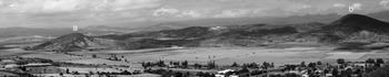
(a) Yucundaa and (b) Yucuanino, as seen looking west from the top of Yucuita. Photo by the author.

The name Sayucunda means At the Foot of (saha) the Blue (ndaa) Hill (yucu). Since the sixteenth century, saha has been used in Mixtec to describe both literal feet and the metaphorical position of being “at the foot of” something (saha: Alvarado Reference Alvarado1593:2r, 167r; sa'a: Caballero Morales Reference Caballero Morales2008:419, 421). Similarly, yucu has meant “hill” or “mountain,” and ndaa has meant “blue” for at least four hundred years (yucu: Alvarado Reference Alvarado1593:62r; yuku: Caballero Morales Reference Caballero Morales2008:755; ndaa: Alvarado Reference Alvarado1593:31r; Caballero Morales Reference Caballero Morales2008:279).
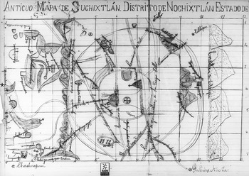
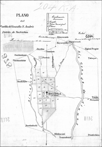
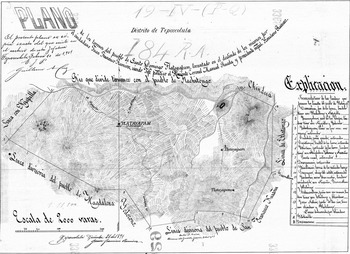
But why does this place name refer to the Foot of a Blue Hill? By looking at land documents housed in Mexican archives, we can see—not surprisingly—that the hill named Sayucunda in INEGI maps is more properly called Yucundaa (Blue Hill), and that Sayucunda refers to a location at its base. A map of the boundaries of Suchixtlan in the Archivo General de la Nación in Mexico City portrays this hill with the associated name “Yucundua” (Figure 8). The map is hard to date. It is labeled as having been copied in 1900 from an older map (which may explain the Yucundua misspelling), and is filed with a series of documents dating to the 1700s. However, the map represents more places than are listed in the eighteenth-century documents it accompanies, and so may not be as old. A 1907 map of the boundaries of Sinaxtla (a southern neighbor of Yucuita), now in the Mapoteca Orozco y Berra in Mexico City, has the hill labeled “Dequeyucunda” (Summit of the Blue Hill); nearby boundary markers are Sayucunda and Satayucunda (Figure 9).Footnote 5 A 1925 boundary map in the Municipio of Yucuita itself shows the hill labeled as the “Cerro de Yucunda” (Hill of the Blue Hill).Footnote 6 Incidentally, the name of this place, Blue Hill, probably relates to a specific geologic feature: a vein of greenstone visible on one side (Plunkett Reference Plunkett1983:157).
“Anticuo Mapa de Suchixtlán.” AGN, Títulos Primordiales 2, Exp. 1. Image reproduced courtesy of the Archivo General de la Nación, Mexico City. The map is oriented with south at the top. The hill labeled “Yucundua” is located near the left edge of the map; I have placed an asterisk by hill and label to make them easier to locate.

“Plano del Pueblo de Sinaxtla.” Mapoteca Orozco y Berra Map 3418-CGE-7272-A. The map is oriented with north to the top. The boundary locations of Dequeyucunda, Satayucunda, and Sayucunda are located near the top of the map, just under the box labeled “Explicación.” Image reproduced courtesy of the Mapoteca Orozco y Berra, Servicio de Información Agroalimentaria y Pesquera, Secretaría de Agricultura, Ganadería, Desarrollo Rural, Pesca y Alimentación, Mexico.

We know from sixteenth-century sources that the Mixtec word blue, ndaa, was often represented in place signs by using the “jewel” sign (Smith Reference Smith and Benson1973b:81; cf. Smith and Parmenter Reference Smith and Parmenter1991:21–24). For example, the Mixtec name for the town of Tejupan (28 km to the northwest of Yucuita, in the next valley over) is Ñundaa, Blue Land or Blue Town. In a map of the town created around 1580 (in response to the Relaciones Geográficas survey), a green hill sign was ornamented with a round jewel nearly identical to the symbol adorning the Hills of the Jewel in the Codex Nuttall and the Codex Vienna pages discussed here (Mundy Reference Mundy1996:79–80, 158–159; Smith Reference Smith1973a:239). Indeed, a land document from 1718 names a hill on the border between Tejupan and Tamazulapan as “Yucundaa,” Blue Hill.Footnote 7 As Pohl (Reference Pohl, Hendon and Joyce2004:231) notes, one could interpret the Hill of the Jewel place in the Codex Nuttall and the Codex Vienna as Tejupan. But a number of pieces of contextual evidence argue against this.
First, in the Codex Nuttall image, Yucundaa is painted just after the signs for Yucuita and Yucuñudahui. Similarly, in the northern Nochixtlan Valley, Yucuita and Yucuñudahui and Yucundaa are all within a few kilometers of each other, intervisible. The closeness of these places on the ground and in the screenfolds argues against the identification of this particular Hill of the Jewel as Tejupan. Furthermore, spatial interconnectedness is reinforced by political interconnectedness. As mentioned above, Yucuita was a community subject to Yanhuitlan in the sixteenth century, and Hill of Feathers and Blue Hill are linked in both the Codex Nuttall and the Codex Vienna to Lord 7 Motion, who was named as one of the deities worshipped by the nobles of Yanhuitlan. As far as we know, no such political or ritual connections tied Yanhuitlan to Tejupan.
Another point arguing against the Tejupan identification is that the Blue Hill in the Codex Nuttall and the Codex Vienna is always paired with a Hill of Feathers, and this second hill does not appear in the 1580 map from Tejupan.Footnote 8 Indeed, on both Codex Vienna 44 and 4, the Blue Hill is actually connected to the Hill of Feathers place sign (Figure 6). Turning to physical geography, the Yucundaa near Yucuita is also connected to a second hill. Both rise from the same limestone foundation, and are joined by a low ridge called La Palmita (Plunkett Reference Plunkett1983:284) (Figure 7). This second, taller hill is currently called Yucuanino, and from archival documents we know this name dates back to at least 1778.Footnote 9 But the name Yucuanino does not contain any of the Mixtec words for feathers, or even cape. In the late sixteenth century, feathers were dzoo or tnumi; a “manta guarnecida có[n] pluma” was translated in 1593 as dzoo indaa tnumi and dzoo caa tnumi (Alvarado Reference Alvarado1593:168v, 145r). Nevertheless, Yucuanino is almost certainly the Hill of Feathers shown in the Codex Nuttall and the Codex Vienna, because the Hill of Feathers sign includes another important feature.
Etymologically, Yucuanino has three parts. I mentioned above that yucu means “hill.” As Mary Elizabeth Smith pointed out long ago, in and around the Nochixtlan valley a- is a locative prefix, and can be translated as “place of” or “place where something exists” (Smith Reference Smith and Benson1973b:80, 86). Finally, nino, according to Francisco de Alvarado's 1593 dictionary of Mixtec, means “tall, or up high” (“Alto. l, en alto, nino,” Alvarado Reference Alvarado1593:17v; see also more recent examples in Alexander Reference Alexander1980:237; Caballero Morales Reference Caballero Morales2008:378).Footnote 10 In its most famous uses, the a- prefix is combined with a noun: Atoco, Place of Cochineal; Añute, Place of Sand; Ayuu, Place of Stone; Achuchi, Place of Gravel; Andutu, Place of Paper (Hermann Lejarazu Reference Hermann Lejarazu2003:144, 152, 153; Smith Reference Smith and Benson1973b:42, Reference Smith, Flannery and Marcus1983). However, recent work on Mixtec place names in and around the Nochixtlan Valley has shown that the a- locative prefix is sometimes combined with an adjective: Andutu, Brilliant Place (Lugar Brillante); A Yichi, Always-Dry Place (Lugar Siempre Seco); A kama, Fast Place (Lugar Rápido) (Geurds Reference Geurds2007:248, 249, 251). Another recently discussed example prefaces the a + adjective combination with itnu, a topographic term meaning low hill: Itnu achito, Low Hill of the Full Place (loma del lugar lleno) (Hermann Lejarazu Reference Hermann Lejarazu2003:196). Following these models, the translation of the hill name Yucuanino would be Hill of the High Place. “High” is a relational property, difficult to express visually (compare with Teozacoalco's Mixtec name: Chiyo Cahnu, Wide Platform; Smith Reference Smith1973a:58). However, because Yucuanino is connected on the ground to the lower Yucundaa, Mixtec scribes were able to represent this “high” quality visually, at least in the Codex Vienna. On both pages 44 and 4, the Hill of Feathers is drawn significantly taller than its companion, the Hill of the Jewel (Figure 6). This intentional spatial contrast, I argue, is meant to represent that the Hill of Feathers is a nino, a High Place.
But what are the feathers doing there? I suspect that Yucuanino once had a longer, two-part name, which has now been forgotten. We know that many places in Mesoamerica had multipart names. The most famous example in the Mixteca is Tilantongo. In the town's answers to the circa 1580 Relaciones Geográficas survey, Tilantongo's full name was given as Ñutnoo Huahindehui: Black Town, Temple of Heaven (Acuña Reference Acuña1984:234; see also Stuart and Houston Reference Stuart and Houston1994). I suspect that the hill now known only as Yucuanino was once known as something like Hill of Feathers, Hill of the High Place. The earliest securely datable document I have found listing a name for Yucuanino is from 1778—that is, over 250 years after the Europeans arrived, plenty of time for complex pre-Hispanic names to have been shortened or forgotten.
PEÑA DEL AGUILA AND YUCUAYAHUA
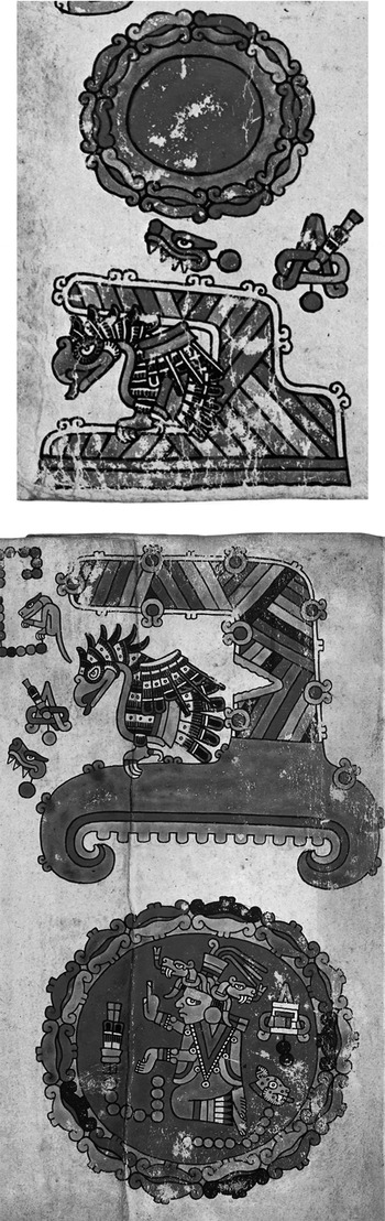
On both Codex Vienna 44 and Codex Vienna 4 to 3, the Blue Hill/Hill of Feathers pair is followed by the same two place signs (Figures 2d, 2e, 3d, 3e, and 10). The first is a red circle surrounded by stones. This is a complex sign to interpret, and we will deal with it towards the end of this essay. The second is a curved stony hill with an eagle: a Cave of the Eagle. I identify this sign with a cave, now called Peña del Águila, located a few kilometers southeast of Nejapilla and a few kilometers southwest of Santo Domingo Tlatayapan (Figures 3 and 4).Footnote 11
Stony Enclosure and Cave of the Eagle on Codex Vienna 44 (top) and Codex Vienna 3 (bottom).

To understand this identification, we turn again to the Yanhuitlan idolatry investigation. On October 16, 1544, two Europeans living in the Mixteca gave related testimonies about supposedly-idolatrous acts being committed near Tlatayapan. Like Yucuita, Tlatayapan was a town subject to Yanhuitlan according to various sixteenth-century documents (Jiménez Moreno and Mateos Higuera 1940:3; Sepúlveda y Herrera Reference Sepúlveda y Herrera1999:62). The testimony given by Juan de Naveda (who was serving as mayordomo in the town of Huautla for its encomendero, Joan Ochoa) is fairly brief: “and he also learned from the Indians about how in another cave which was in the subject community of Yanhuitlan which is called Tlataloyotepeque which they said had a great sacrifice inside, and he arrived with some Indians from Huautla to see it and three or four Indians went in to see it and they found two dead doves and a lot of blood, feathers and two hearts, human and rotten….”Footnote 12 The testimony given later the same day by Juanes de Angulo (vicar of the town of Apoala) is more extensive:
And similarly he heard tell from Juan de Naveda that he had gone to a cave which was in the subject community of Tlatalotepeque with some Indians, going to search for the sacrifice which they had said was there, and that he had found many sacrifices of feathers, doves, and other things and two human hearts as if they had been sacrificed and this witness saw some of the said sacrifices, and in the said community and town, this witness going to Chachoapan, an Indian who went with him and with Juan de Naveda told him that there in the said small mountain the people of the community of Tlatalotepeque sacrifice and they went there (this was a year ago) and found in a small mountain that the Indians call q u i a v g y signs of how their poles for the flying ceremony had been there, from which he who is the indigenous religious leader suspends himself to call for rain, as the Indians say and indicate, and he found lots of parrot feathers and blood and other birds and things and some stone idols on top of a flat stone, like an altar, and other sacrifices and images of the devil.Footnote 13
According to these testimonies, somewhere near the town of Tlatayapan (“Tlatalotepeque”) was a cave in which sacrifices were performed, as well as a small mountain where the volador ceremony was held to call for rain. Juanes de Angulo attempted to name the small mountain, and the way his words appear in the original transcript is quite striking. Unlike the surrounding fluid cursive prose, the name of this mountain is written out letter by letter: q u i a v g y. Angulo became more confused as he went on: the letter “g” is crossed out, and followed by a tentative letter “y”. It is as if Angulo were struggling, sound by sound, to remember a Mixtec name he heard over a year earlier. Angulo was a priest, and so it is quite possible that he knew some Mixtec. Indeed, he is one of the few European witnesses to include Mixtec words in his testimonies. Deciphering this half-remembered place name is difficult, but not impossible.
The first two letters, “q” and “u,” are probably the half-remembered half of the Mixtec word for hill. As we saw above, this word was usually written as yucu in the sixteenth century. However, early modern Castilian orthography was not standardized, and there was a great deal of flexibility in spelling. In a testimony from the Yanhuitlan investigation dated to May 11, 1545, the word for hill is spelled not yucu but yuqu, using a “q” instead of a “c.”Footnote 14 Not surprisingly, then, the sacred mountain near Tlatayapan where sacrifices were performed was called Yucu-something. This leaves us with four more half-remembered sounds: “i,” “a,” “v,” and “y.” I argue these were originally part of the word yahua. The letter “i” often substitutes for “y” in early modern Castilian, so the i-a string could have been pronounced ya-. Similarly, the letter “v” was often used to represent a glottal stop or glide in sixteenth-century Mixtec, followed by a vowel (Terraciano Reference Terraciano2001:77). For example, the Mixtec term for rain (lluvia in Castilian), often written savi or sawi in twenty-first century orthography, was in the early Colonial period written both dzavui and dzahui (Alvarado Reference Alvarado1593:141r; Caballero Morales Reference Caballero Morales2008:433; Stark Campbell et al. Reference Stark Campbell, Peterson and Cruz1986:124; Terraciano Reference Terraciano2001:403, Note 1).Footnote 15 The word for “like this, thus” (asi in Castilian), which in its current forms always includes a glottal stop (ja'va, su'a, du'wa, du'va) was in 1593 written as dzavua (Alvarado Reference Alvarado1593:28r; Caballero Morales Reference Caballero Morales2008:472). This reading gives us Yucu Yavu- or Yahu- something. As it happens, one of the peaks in the mountain range directly to the south of Tlatayapan is named as Yucuayahua in a number of archival documents, the earliest from 1862.Footnote 16 One of these records, a map copied in 1907, is drawn to scale and includes rivers and topographic information; this allows us to specify exactly where the Yucuayahua peak is located in the mountains south of Tlatayapan (Figure 11). Not surprisingly—given the testimonies of Naveda and Angulo—two caves are located beneath this particular summit.
“Plano de los Terrenos del Pueblo de Santo Domingo Tlatayapam.” Mapoteca Orozco y Berra Map 3369-CGE-7272-A. The map is oriented with north to the top. The hill of Yucuayahua is located near the left edge of the map, and is labeled with a number 2. Note that “Tlatayapan” is sometimes spelled “Tlatayapam.” The summit of Debueyuculuchi is not labeled on this map, but it is located between points 3 and 4 (closer to 4) and represented as an elongated figure-8-shaped space framed in hatch lines. Image reproduced courtesy of the Mapoteca Orozco y Berra, Servicio de Información Agroalimentaria y Pesquera, Secretaría de Agricultura, Ganadería, Desarrollo Rural, Pesca y Alimentación, Mexico.

According to Origins of the Ñuu, caves called Crag of the Eagle and Crag of the Virgin (Peña del Águila and Peña de la Virgen) are located in the mountain south of Nejapilla called Debueyuculuchi (Kowalewski et al. Reference Kowalewski, Balkansky, Walsh, Pluckhahn, Chamblee, Rodríguez, Espinoza and Smith2009:43). By superimposing the 1907 map of Tlatayapan over more recent INEGI maps, it is clear that the Debueyuculuchi peak is just east of the Yucuayahua peak; both are part of the same promontory (see Figures 4 and 5; the Debueyuculuchi summit is indicated but not labeled in Figure 11). Debueyuculuchi is slightly higher than Yucuayahua, which is no doubt why the former name was used by INEGI cartographers. Thanks to GPS coordinates kindly shared with me by Laura Stiver Walsh, I have been able to confirm that the Eagle and Virgin caves are indeed located right below the peak named Yucuayahua on the1907 map.
The very name Yucuayahua suggests tantalizing connections to one of the caves contained within this hill. One possible translation of Yucuayahua is Hill (Yucu) of the Place (a-) of the Frog (teyahua in sixteenth-century orthography, ja'va diva and sa'va today) (Alvarado Reference Alvarado1593:178r; Caballero Morales Reference Caballero Morales2008:436). A second, and perhaps more likely translation is Hill of the Place of the Eagle (yaha in sixteenth-century orthography and ya'a or ya'va or tiya'va in contemporary orthography) (Alvarado Reference Alvarado1593:12r; Caballero Morales Reference Caballero Morales2008:731). This translation is quite similar in meaning to the name of one of the caves located beneath this summit: Peña del Águila. In Mixtec place names from the Nochixtlan Valley the word cavua can mean both peña (crag) and cueva (cave) (Byland and Pohl Reference Byland and Pohl1994:68, 85–87; Smith Reference Smith1973a:47). This suggests that the cave now called Peña del Águila in Spanish may have once been called Cavuayaha in Mixtec, that is, Cueva del Águila. I therefore propose that the sacred cave near Tlatayapan discussed in the Yanhuitlan investigations is the cave called Peña del Águila today, and that the Cave of the Eagle place shown on Codex Vienna 44 and 3 is this same cave.Footnote 17 Further on-the-ground research is needed to find out if Mixtec names for these two caves, and the peak they are located beneath, are still known today. At the very least, we do know that a number of Mixtec place names were translated faithfully to Castilian during the Colonial period (see Hamann Reference Hamann2008a), and so it is quite possible that the cave called Peña del Águila today was called Cavuayaha in the sixteenth century.
Indeed, the presence of a Cave of the Eagle (Cavuayaha) in a Hill of the Place of the Eagle (Yucuayahua) may explain why volador ceremonies were held here. According to Alvarado's Reference Alvarado1593 vocabulary, the artificial flight achieved by the volador ceremony was described as yosicoyahandi: “I fly like an eagle” (Alvarado Reference Alvarado1593:36r; Terraciano Reference Terraciano2001:267). Eagles are known for their wide circular flight paths, using outspread wings to catch rising air currents.Footnote 18 In turn, the spiraling volador ceremony was linked to sacrifice and rainmaking throughout pre-Hispanic Mesoamerica (Beekman Reference Beekman2003; Urcid Reference Urcid2006). In the 1540s, in front of the Cave of the Eagle, below the Hill of the Place of the Eagle, indigenous priests soared round and round like eagles to call for rain.
As a final point, note that contextual evidence in the Codex Vienna further strengthens this identification. On Codex Vienna 3, Cave of the Eagle is the place sign shown directly before Ballcourt Hill (Figure 3e-f). As John Pohl has pointed out, Ballcourt Hill (Yucu Yuhua) is the Mixtec name of Santo Domingo Tlachitongo, which is the town immediately to the northeast of Tlatayapan (Pohl Reference Pohl, Hendon and Joyce2004:230, 233; cf. Jansen and Pérez Jiménez Reference Jansen and Jiménez2007:137). Ballcourt Hill appears on both Codex Nuttall 3 and Codex Vienna 3. In both instances Lady 11 Serpent appears at the site. On Codex Nuttall 3 she is joined by Lord 11 Crocodile (name glyph only), and on Codex Vienna 3 she is joined by Lord 10 Lizard (Figures 1k, 1l, and 3f-3h). All three of these deities are named in the Yanhuitlan documents (Jansen Reference Jansen1982:284).
TOWN OF BLOOD, HILL OF THE SCAFFOLD
If the Ballcourt Hill shown in the Codex Nuttall and the Codex Vienna is indeed Tlachitongo, then we can expect that the Town of Blood, Hill of the Scaffold (shown immediately before Ballcourt Hill on Codex Nuttall 3 and immediately after Ballcourt Hill on Codex Vienna 3) is somewhere nearby (Figure 12; see also Figures 1i and 3f-3i). This should be a place connected to Yanhuitlan as well. The Town of Blood sign is associated with Lord 7 Wind in both the Codex Nuttall and the Codex Vienna, and he is another one of the deities named in the Yanhuitlan investigation.
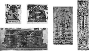
Town of Blood–Hill of the Scaffold on Codex Nuttall 3 (top left), Codex Vienna 3 (top right), Codex Vienna 43 (bottom left); scaffold sacrifice on Codex Becker 10 (center); scaffold sacrifice on the Cross of Topiltepec (far right). Drawing by Agustín Villagra (from Caso Reference Caso1956:175).

The representation of the Town of Blood, Hill of the Scaffold place in the Codex Nuttall is somewhat simpler than that in the Codex Vienna. In the Codex Nuttall, only a ñuu (town or place) frieze with a gush of downflowing blood is shown, perched atop a hill glyph that is half green, half striped with stone. In contrast, on both page 43 and 3 of the Codex Vienna the hill with the bloody ñuu frieze is further decorated with an elaborate scaffold of lashed poles (Figures 2f and 3i). These two iconographic details probably indicate a two-part name: Town of Blood, Hill of the Scaffold is a likely candidate (compare with the Yucuanino discussion above). What is especially striking about the combination of scaffold with gush of blood in both of the Codex Vienna representations is how much it resembles Mixtec depictions of scaffold sacrifices (Codex Zouche-Nuttall 1987:84; Taube Reference Taube, Benson and Griffin1988:332). The lower part of the scaffold sacrifice shown on page 10 of Codex Becker I (1961) looks uncannily like the place signs on Codex Vienna 43 and 3 (Figure 12).
If this place sign were meant to visually recall the iconography of scaffold sacrifices, and if it represents a place near Tlachitongo, then perhaps it represents a place located within the boundaries of Topiltepec, the town directly to the north of Tlachitongo (Figures 4 and 5). Like Yucuita and Tlatayapan, Topiltepec was a town subject to Yanhuitlan in the sixteenth century, and is named a number of times in the Yanhuitlan documents. For example, in October 1544 Don Cristóbal, gobernador and alguazil of Nochixtlan, testified that “one year when it did not rain, in a subject town of Yanhuitlan which is called Topiltepec they sacrificed and killed many precious stones and doves and to this festival went Don Francisco and Don Juan and Don Domingo [the three accused nobles from Yanhuitlan].”Footnote 19
Today, Topiltepec is most famous for its carved stone monolith, which depicts a scaffold sacrifice on one side and the ascent of the sun and moon into the sky on the other (Callaway Reference Callaway1990a, Reference Callaway1990b; Caso Reference Caso1956) (Figure 12). In the Colonial period, this monolith was topped with two additional stones, transforming it into a cross. This modification therefore transformed the bleeding sacrificial victim into Jesus Christ. Overall, the iconography of the cross probably relates to ideas about the primordial sacrifices needed to create the sun and moon at the beginning of time. In central Mexican beliefs, the sun and moon were created at the ruins of Teotihuacan when two gods sacrificed themselves and then rose, reincarnated as celestial bodies, into the sky. We know that parallels to central Mexican narratives about Teotihuacan are recorded in the Mixtec screenfolds (Hamann Reference Hamann and Blomster2008b:125–127; Taube Reference Taube, Carrasco, Jones and Sessions2000:314), and so the two sides of the Topiltepec cross probably relate to a similar narrative. A sacrifice on one side allows, on the other, the sun and moon to ascend into the heavens. Alternatively, the depiction of the sun and moon together may indicate an eclipse. In the Colonial period, this would have merged quite well with Christian narratives about the crucifixion, which describe how the sky went dark at Jesus' death.Footnote 20
Perhaps, then, a hill near Topiltepec was associated with the primordial sacrifice that helped create the sun and moon. After all, according to Codex Nuttall 3, neighboring Tlachitongo (Ballcourt Hill) was the site where a primordial decapitation created pulque from divine blood (Figure 1k and ll). The victim was the goddess Lady 11 Serpent, who again is one of the deities mentioned in the Yanhuitlan documents (Furst Reference Furst1978:167–168; compare with Taube Reference Taube1993:4). However, none of the archival documents about Topiltepec that I have seen—documents focused above all on the town's boundaries—mention any place called Town of Blood or Hill of the Scaffold. The Mixtec name for Topiltepec itself translates as Hill of the Staff (Yucutagno) (Martínez Gracida Reference Martínez Gracida1883; Pohl Reference Pohl, Hendon and Joyce2004:232). Maps of Topiltepec's boundaries from 1961 and 1964 identify a large hill due north of the main town as “Cerro de la Cantera o de la Cruz.” Perhaps this Hill of the Cross was once called Hill of the Staff?Footnote 21 More research is therefore needed to find out if any geographic features within Topiltepec's boundaries have sacrificially-associated names. This highlights one of the limits of using boundary documents: these texts focus on places that occur between towns. Important locations within town boundaries are seldom named.
One final piece of visual-contextual information further strengthens the connection of Topiltepec to the Town of Blood, Hill of the Scaffold sign. At the beginning of this section, I mentioned that the Town of Blood place should be near Ballcourt Hill, since the two signs are next to each other in both Codex Nuttall 3 and Codex Vienna 3. This is in fact the case: Topiltepec is just north of Tlachitongo. Furthermore, in both the Codex Nuttall and the Codex Vienna the Ballcourt Hill-Town of Blood sequence is continued by a third sign: a Black Hill. Black Hill appears at the center of Codex Nuttall 3, and is in the lower-right corner of Codex Vienna 2 (Figures 1f and 3l). John Pohl (Reference Pohl, Hendon and Joyce2004:231) argues that this sign represents Tiltepec, located 5 km to the south of Yanhuitlan and directly north of Topiltepec (Figures 4 and 5). The sequential on-the-ground order of Tlachitongo-Topiltepec-Tiltepec is therefore matched by the sequential screenfold order of Ballcourt Hill-Town of Blood-Black Hill. Tiltepec is frequently mentioned in the Yanhuitlan documents. Among other things, when Tiltepec's ruler died, his brother Don Domingo (who was the cacique of Yanhuitlan) went to perform the sacrifices associated with burial rites.Footnote 22 In addition, one of the gods worshipped in Yanhuitlan, Lord 7 Wind, is painted next to Black Hill on both Codex Nuttall 3 and Codex Vienna 2 (Jansen Reference Jansen1982:284) (Figures 1g and 3m).
YUCUMAÑU
An arc of adjacent places can now be traced through the Codex Nuttall and the Codex Vienna and across the landscape of the northern Nochixtlan Valley. Retracing our steps, this arc moves counterclockwise from Tiltepec, to Topiltepec, to Tlachitongo, to Yucuayahua and the Peña del Águila, to connected Yucundaa and Yucuanino, to Yucuita, and finally Yucuñudahui (Figures 4 and 5). But as I mentioned above, there is another location to study in this circuit. On both Codex Vienna 44 and Codex Vienna 3, a stone-bordered red circle is painted between Blue Hill and Hill of Feathers, on the one hand, and Cave of the Eagle, on the other (Figure 10). I argue that this stone-circled enclosure, associated with the goddess Lady 9 Reed, is the cave now called the Cave of the Lord (La Cueva del Señor), located on the high mountain ridge that runs north to south down the center of the Nochixtlan Valley.
Once again, this identification begins by turning to the Yanhuitlan idolatry investigation. Perhaps the most important sacred location in the Yanhuitlan documents is a hill called Yucumaño, Yuqumeñu, or Yucumayo. It is mentioned in 10 different testimonies. Some sacrifices were said to be performed at its base, and others were performed in a cave within it. The cave is said to be located “on the boundaries of Etlatongo, behind a large hill of the said town.”Footnote 23
No Yucumaño-like place name is listed on maps of the Nochixtlan Valley published by INEGI in the late twentieth century. Fortunately, older sources—archival documents and maps— include a half-dozen references to this place, the earliest from 1717.Footnote 24 As the Yanhuitlan testimonies claim, Yucumañu (also spelled Yucumaño) is indeed adjacent to Etlatongo. It is part of the long mountain ridge that runs down the center of the Nochixtlan Valley. This ridge rises up just south of Chindua and Etlatongo and ends near Tilantongo and Jaltepec (where its final promontory is called Hill of the Wasp) (Byland and Pohl Reference Byland and Pohl1994:57, 94–98).Footnote 25
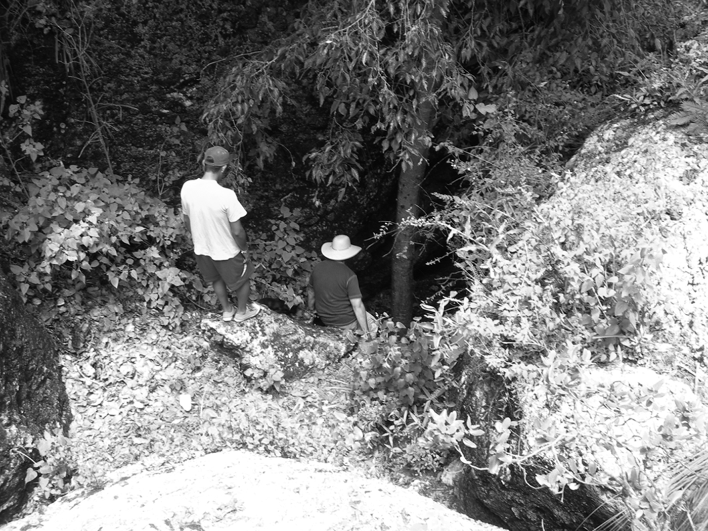
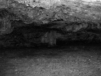
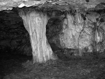
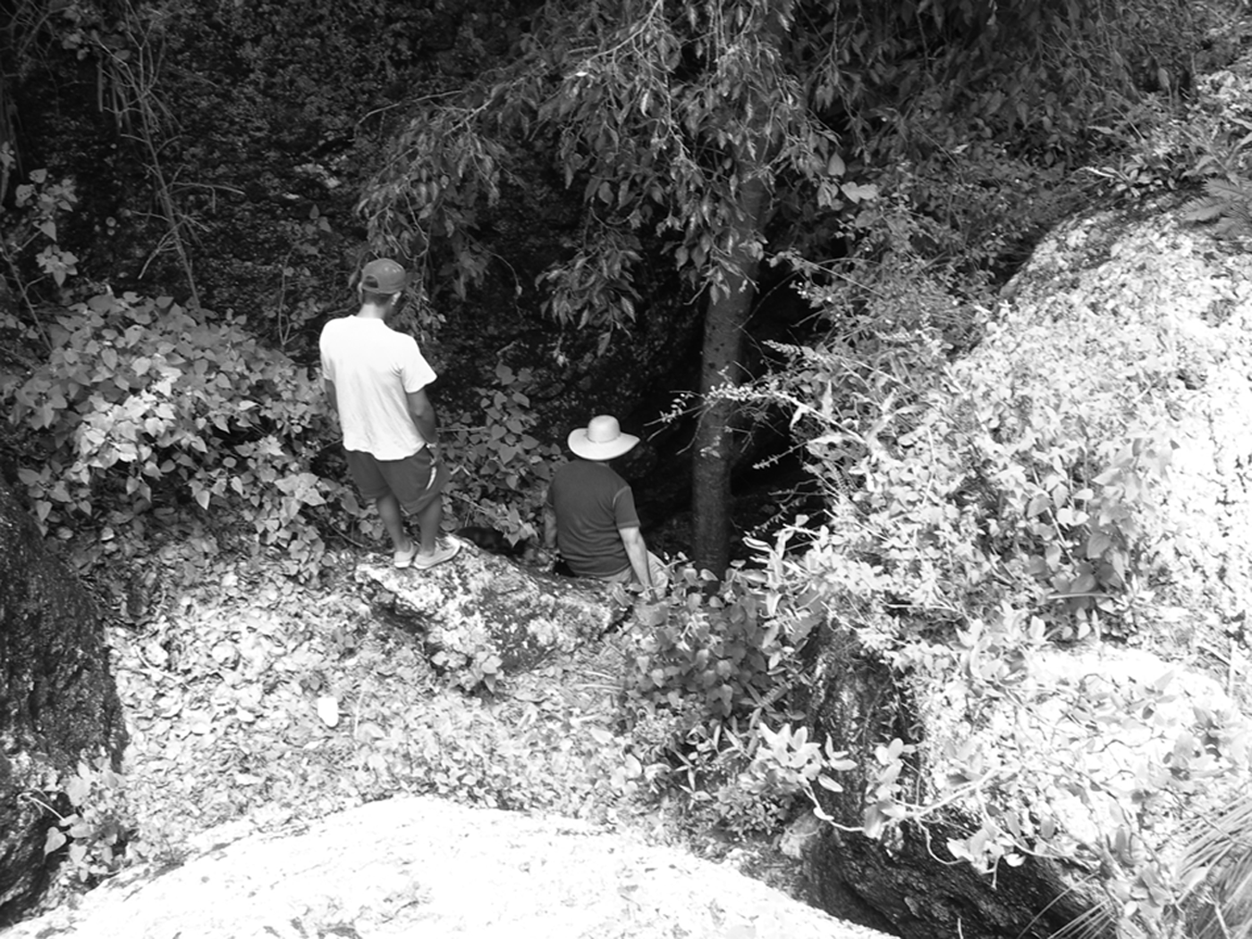
On the basis of this information, I went to see Yucumañu in the summer of 2007. Thanks to the advice of Jeff Blomster and some of his friends from Etlatongo, I was able to confirm the existence of a cave on the top of Yucumañu, and to visit it. Geologically, this Cueva del Señor (Cave of the Lord, “el Señor” often referring to Jesus in Spanish-speaking Catholicism) is quite interesting. Unlike the more famous caves of Mixtecan archaeology—the Cavua Cuee near Jaltepec (Byland and Pohl Reference Byland and Pohl1994:68), the two caves just to the north of Yucuita in Totohuada (Plunkett Reference Plunkett1983:176; Spores Reference Spores1972:119–120), and the Ndaxagua natural bridge in the Coixtlahuaca Valley (Rincón Mautner Reference Rincón Mautner2005:5; Urcid Reference Urcid2004)—the Cueva del Señor is not horizontally burrowed into the side of a hill or a cliff face. Rather, the Cueva del Señor is at the bottom of a sinkhole. One has to climb vertically down into the earth before entering the underground chamber (Figure 13). The cave itself is about 5 m deep by 7 m wide, with a roof currently 1.5 m high at its tallest points. The most interesting feature of this cave is a thick white column of mineral deposits that connects the floor to the ceiling (Figures 14 and 15). This stalactite-stalagmite combination is almost directly in front of where the cave mouth opens. The site is still used to make offerings, and this mineral column is a focus for them. On my visit, I saw a number of votive candles, a shell cross smeared with blood, a prayer card, a water-damaged photo, and a closed plastic bottle partially filled with liquid (probably mescal).
Descent into the Yucumañu sinkhole. Photo by the author.
Yucumañu cave, general view. The mineral column is in the center of the photo at the back of the cave. Photo by the author.

Yucumañu cave, mineral column and votive offerings. Photo by the author.

Given that so many of the deities mentioned in the Yanhuitlan investigation appear on Codex Nuttall 3 and Codex Vienna 4 to 1, and given that these pages also show many places in the northern Nochixtlan Valley, I was puzzled why Yucumañu—one of the most important sacred locations in the Yanhuitlan testimonies—was not obviously represented. Yucumañu means Middle Hill (mañu: Alvarado Reference Alvarado1593:67r, 69r; ma'ñu: Caballero Morales Reference Caballero Morales2008:250). I assume this name relates to the ridge's physical location, running north to south down the middle of the Nochixtlan Valley. Yet I could not find any candidate for a Middle Hill sign in either the Codex Nuttall or the Codex Vienna. However, I now believe that the screenfolds depict the cave of Yucumañu. This is the round red circle enclosed by stone glyphs that appears on Codex Vienna pages 44 and 3 (Figures 3d and 10).
How are we to interpret the stone-circled red sign in Mixtec? What kind of geographic feature does it represent? These are difficult questions to answer. This sign shows up only three times in the Codex Vienna (the third example is on page 23), and has no direct equivalent in any other Mixtec screenfold. However, its distinctive color scheme (a circular red center framed in a gold band, surrounded by stones) does appear elsewhere. This is how “earth openings” are depicted in the screenfolds, but they are normally shown in profile. Consider the first page of the Codex Nuttall (Figure 16). Above, Lord 8 Wind stands upon the rounded green-and-black shape of a hill glyph. Behind him is the cleft in the earth from which he has just stepped: it appears as a semicircular opening in the hill, with lobed yellow lips surrounding a red center. Directly below this scene (and this is probably where the narrative of page 1, and the screenfold as a whole, actually begins) Lord 8 Wind emerges from another such cleft. Once again, this cleft has a red center, surrounded by lobed yellow lips. But in this case, the earth opening is not set in a green and black hill. Rather, it opens from an oblong stone banded in green, red, blue and orange. The round place glyph on pages 44 and 3 of the Codex Vienna, I argue, is meant to represent such an earth opening, but represented from above, not from the side. This is why it is circular, nor semicircular, and why the yellow lips surrounding the red opening form a circle, not a lobed half-circle. Indeed, small red circles surrounded by yellow rims are probably meant to indicate caves on Codex Vienna 21, 14, and 10. The red and yellow circles of the sign on Codex Vienna 3 are themselves enclosed in a circle of stone glyphs, indicating that this opening is breaking through rock—again, a “from above” version of the stone-emergence iconography seen in the lower right-hand corner of Codex Nuttall 1. This earth-orifice in stone, I argue, perfectly portrays the sinkhole structure of the Cueva del Señor. Again, this is not a cave which opens into the side of a mountain or cliff. Because of its unusual geologic structure, the artists who created these two round place signs in the Codex Vienna did not use the standard cross-sectioned “cave” glyph found throughout the Mixtec screenfolds. The standard cave sign, as we saw above, is used in the Vienna to represent the Cave of the Eagle (Figure 10). But the Cueva del Señor is a very different type of geologic formation, and the earth-orifice-based place sign on Codex Vienna 44 and 3 was likely meant to indicate its unusual physical form.
Lord 8 Wind emerges from earth openings on Codex Nuttall 1.

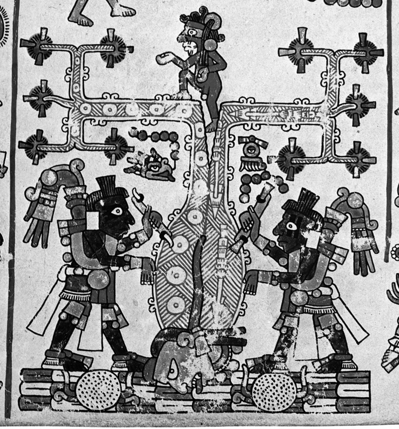
The representation of this place on Codex Vienna 3 shows it to be the home of Lady 9 Reed, yet another deity named in the Yanhuitlan documents (Jansen Reference Jansen1982:285). This goddess is the personification of the white-barked Mixtec birth tree from which—according to page 37 of the Codex Vienna—the Mixtec ancestors emerged at the beginning of time (see Furst Reference Furst1977; Geurds Reference Geurds2007:229; Ibach Reference Ibach1980) (Figure 17). I argue that the creamy white mineral column in the Cueva del Señor was viewed by pre-Hispanic Mixtecs as an incarnation of Lady 9 Reed. In other words, despite centuries of Christian iconoclasm, she is still present in the Yucumañu cave.
Carving the white trunk of Lady 9 Reed, the Birth Tree, on Codex Vienna 37.
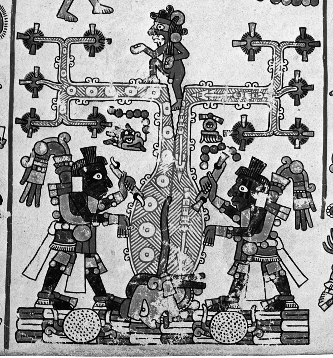
Multiple lines of evidence support this interpretation. First, according to the testimony of Juanes de Angulo (introduced above),
this witness has heard tell from Juan de Naveda calpisque of Huautla and from other Indians of Huautla that the said Don Francisco governor, when there was a drought last year, had sacrificed one of his slaves in a large cave in the border of Etlatongo, behind a large hill of the said town, where they say that he has a great idol that they adore and to whom they sacrifice.Footnote 26
The so-called “idol” in the Yucumañu cave was probably the column still there today. It is over a meter and a half in circumference, and certainly existed 500 years ago. As Janet Fitzsimmons Steele (Reference Steele1997) has shown, rock formations in caves—especially stalactites and stalagmites—have been regarded as divine beings throughout Oaxaca for centuries. Perhaps the most famous sacred speleothem in the Mixteca today is the Archbishop, a stalagmite in Apoala's Yahui Coo Maa cave (Jansen Reference Jansen1982:92; see also Heyden Reference Heyden, Brady and Prufer2005). During the sixteenth and seventeenth centuries, Christian missionaries referred to these formations in their writings as idols, ídolos. As idols, of course, these sacred manifestations were the targets of Christian desecration (Steele Reference Steele1997:3). Francisco de Burgoa even describes an attack on the ice formations in a high-altitude cave by a Friar Gerónimo de Abrego as an act of iconoclasm (Terraciano Reference Terraciano2001:267). Abrego broke up the caves' icicles and melted them into water, which he then drank. Abrego's action was clearly inspired by the Old Testament. In the biblical book of Exodus (32:19–20), when Moses discovered the Israelites worshipping a golden calf, he ordered that the idol be ground into powder. The gold dust was mixed with water, which Moses then forced his people drink. Consumption of an “idol”—whether of gold or of ice—proved that it was not a god (Cummins Reference Cummins2002:125–126).
The rock formation in the Yucumañu cave is a floor-to-ceiling column, and its ribbed irregular sides look a great deal like the trunk of a white-barked tree (Figure 16). Such underground columns have been identified as underworld trees by other Mesoamerican peoples (MacLeod and Puleston Reference MacLeod, Puleston, Robertson and Jeffers1978:74–75; Pohl and Pohl Reference Pohl and Pohl1983; Tate Reference Tate1992:132). As I mentioned above, Lady 9 Reed—who is shown inside the earth opening sign on Codex Vienna 3—was a personification of the white-barked birth tree. This rock formation, then, may be the “great idol” in the cave behind Etlatongo that Juanes de Angulo mentioned in 1544. Indeed, as John Pohl (personal communication 2010) pointed out to me, Lady 9 Reed is shown emerging from the jaws of a cave on bone 174a from Monte Alban's Tomb 7 (see Caso Reference Caso1979:308). A year date in front of her carved image may be 2 House—which would be the same date associated with her stone-enclosed appearance on Codex Vienna 3.
BEYOND YANHUITLAN: YUCUDAIÑO AND YUCUYAHUI
Up until now, I have focused on a set of place signs (and associated deities) that appear on both Codex Nuttall 3 and Codex Vienna 4 to 1. Many of these places were said to be sites for sacrifice in the mid-1540s, and many of the beings depicted at them in the screenfolds are named as “idols” by inquisitorial witnesses. In this final section, I propose two more correlations for place signs depicted in the final pages of the Codex Vienna. Neither location is connected to deities named in the Yanhuitlan documents, but my identifications build on the spatial and ritual contexts established in the previous sections of this essay.
As I have argued, Codex Nuttall 3 and Codex Vienna 4 to 1 present the same basic place signs. However, the sequential order of these place signs is different. The path traced on Codex Nuttall 3 runs as follows (places not shared by both sequences have been placed in italics):
In contrast, the path on Codex Vienna 4 to 2 runs
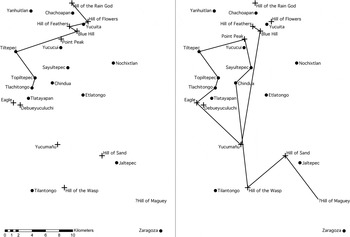
By comparing the order of place signs in these two sequences with my on-the-ground identifications, we can understand why these two lists are different. They track different paths across the same landscape (see Figure 18). Geographically, the Codex Nuttall account moves counterclockwise: from Hill of the Rain God south to Hill of Flowers, then west to Hill of Feathers and Blue Hill, then west again to Black Hill, then south to Town of Blood, and finally south again to Ballcourt Hill. In contrast, the path on Codex Vienna 4 to 2 runs clockwise: from Hill of Feathers and Blue Hill south to Stone Enclosure, then west to Cave of the Eagle, then north to Ballcourt Hill, north again to Town of Blood, and north again to Black Hill. Note that these paths are not necessarily routes for walking. The Nochixtlan Valley has incredible inter-site visibility; it is possible to see both Monte Negro and Jaltepec, far to the south, from Yucuñudahui, far to the north. The routes in the Codex Nuttall and the Codex Vienna, then, could be traced in the eyes and mind from mountaintop locations, above all from the summit of Yucuñudahui.Footnote 27
Mapped comparison of the itineraries on Codex Nuttall 3 (left) and Codex Vienna 4 to 1 (right).

In other words, my on-the-ground correlations explain why the parallel place signs shown in both the Codex Nuttall and the Codex Vienna are not listed in the same order. These screenfolds depict two different routes though the same geographic space. This is an additional piece of evidence supporting my correlations. If my on-the-ground identifications were incorrect, it is unlikely that the relative positions of these different hills would match so perfectly the different sequential relations of signs in the Codex Nuttall versus the Codex Vienna. My identifications are therefore consistent with, without contradiction, three different sets of data: the order of place signs in the Codex Nuttall, the order of place signs in the Codex Vienna, and actual physical geography.
I now want to carry the journey begun on pages 4 and 3 of the Codex Vienna a bit further. The Black Hill of Tiltepec is painted in the lower-right corner of Codex Vienna 2 (Figure 3l). It is followed by two currently unidentified places, an Enclosure of Pulque (?) and a Blue Point Peak (cf. Byland and Pohl Reference Byland and Pohl1994:100) (Figure 3n). The fourth and final sign on page 2 is a compound sign with an insect, a spider web, and a stone building (Figure 3o). Pohl argues this sign represents Sayultepec (Yucu Tiyuq, Hill of the Fly) and Chindua (Spiderweb). Both towns are a few kilometers southeast of Tiltepec. What this page 2 sequence suggests is that Enclosure of Pulque (?) and Blue Point Peak should be between Tiltepec and Sayultepec-Chindua.Footnote 28
Blue Point Peak may be a hill just north of Yucucui (a town itself just north of Sayultepec). This place is called “Tende da iño” in the map of Suchixtlan we looked at above (Figure 8) and “Dequedaiño” in late twentieth-century INEGI maps. Tende and deque are both variant spellings for dzeque or peak (Smith Reference Smith1973a:51). Iño, in turn, is a spine, or pointed thing (“Espinoso arbol. yutnu iño:” Alvarado Reference Alvarado1593:104v; “Punta de cosa aguda. Dicoiño:” Alvarado Reference Alvarado1593:175r). Whatever the pointed blue object in the hill sign on Codex Vienna 2 is supposed to represent, it is a pointed thing, an iño. The da linking tende/deque and iño is probably a variant of the a- locative discussed above, with possible connections to the interrogatory ndaa, “where” (Alvarado Reference Alvarado1593:10r; Caballero Morales Reference Caballero Morales2008:279). For example, when a place name featuring an embedded da was translated into Spanish in the early 1700s, the da was ignored: “Yucha dayaha” was explained simply as River (yucha) of the chile (yaha) (see also Geurds Reference Geurds2007:250, 251; Hermann Lejarazu Reference Hermann Lejarazu2003:222).Footnote 29 In sum, “Tende da iño” and “Dequedaiño” can be translated as Peak of the Pointed Thing, a reading that corresponds fairly well to the sign on Codex Vienna 2.
Picking up our itinerary, then, Codex Vienna 2 travels from Black Hill east to Point Peak, then moves south to Chindua and Sayultepec. Chindua, as I mentioned above, is located just to the north of the northern end of long mountain ridge that contains the Cueva del Señor. The southern end of this ridge is a place called Yucu Yoco, Hill of the Wasp, and this is the next sign depicted in the Codex Vienna, in the lower-right corner of page 1 (Figure 3p). In other words, between the lower-left corner of Codex Vienna 2 and the lower-right corner of Codex Vienna 1 we travel down the Yucumañu mountain ridge to the southern end of the Nochixtlan Valley. The sign after Hill of the Wasp on Codex Vienna 1 is the Hill of Sand, or Jaltepec (Figure 3q). On the ground, this is a few kilometers northeast of Hill of the Wasp (Figures 4 and 5). It is also mentioned as a sacred location in the Yanhuitlan investigation. In October 1544, Juan de Naveda testified that “in a mountain which is above Jaltepec which is called ‘of sand’ they bring their offerings to the devil of feathers and slaves and greenstones and blankets and other things….”Footnote 30 The third sign on Codex Vienna 1 is a Hill of Maguey (Figure 3r). This probably corresponds to the Yucu Yahui (Hill of Maguey) listed in eighteenth-century land boundary documents for Jaltepec.Footnote 31 According to these records, this Yucu Yahui is to the southeast of Jaltepec, probably on the ridge of mountains that separates Jaltepec from neighboring Santa Inés Zaragoza.
Taken together, these identifications allow us to trace two parallel, contiguous paths, one in textual space and the other in topographic space. The first traverses the final four pages of the Codex Vienna, and the second traverses the Nochixtlan Valley: beginning in the north, moving south and west, then north again, then east and south, and finally east again (Figure 18).
CONCLUSIONS
This essay was written with two basic goals. First, I wanted to outline proposals for the identification of seven place signs in the Codex Nuttall and Codex Vienna. At the same time, I wanted to highlight a specific method for deciphering Mixtec place signs. Following the example of John Pohl, I have considered a series of related place signs in the Mixtec screenfolds and connected them to a series of geographically proximate places on the ground. From the records of the Yanhuitlan idolatry investigation, we know that in the 1540s these places were connected through ritual practice, political alliances, and association with specific named deities. Thinking about these seven places together, and their multiple pictorial, alphabetic, and geographic connections, allows for a far stronger argument to be made than simply asserting identifications for each separate place in isolation in separate publications. By drawing on the rich (and underused) land records available in Mexican archives, long-term geographic histories have been revealed, histories that avoid the problems (and gaps) created by leaping directly from the pre-Hispanic past to the academic present.
The identifications proposed here open up a number of possibilities for future research. Some of this research is screenfold-specific. As Ferdinand Anders, Maarten Jansen, and Gabina Aurora Pérez Jiménez (Reference Anders, Jansen and Jiménez1994:182) have shown in an excellent chart, many of the places which appear in the final pages of the Codex Vienna also appear earlier in the same screenfold, on pages 47 to 38 (see Figures 2 and 3). However, whereas the final four pages of the Codex Vienna present sixteen large place glyphs, pages 47 to 38 include over one hundred small signs. This earlier section shows a landscape newly-revealed after Lord 9 Wind raised primordial waters into the sky. This is a complicated geographic vision: the world is still being put in order. Using the fairly straightforward connections between places on Codex Nuttall 3 and Codex Vienna 4 to 1 as a framework, future researchers will have a better foundation from which to approach the dense geographies of pages 47 to 38.
These identifications also have implications for future research combining archaeology and history. We have long known that the Classic-period ruins on top of Yucuñudahui (Hill of the Rain God) were sacred to Postclassic-period Mixtecs, who visited them to leave offerings (Spores Reference Spores, Flannery and Marcus1983). The narratives recorded in the Codex Vienna and the Codex Nuttall, both of which prominently feature the Hill of the Rain God, suggest why those ruins were important. Many of the geographic features I have discussed here were occupied in both the Classic and Postclassic periods, or were near important Postclassic settlements. Both Yucuanino and Yucundaa, for example, were the locations of large Classic and medium-sized Postclassic period occupations (Spores Reference Spores1972:115–116). Future archaeological work at these locations will be able to consider the implications of screenfold accounts for occupational history. Is an awareness of sacred events at these places reflected in the archaeological record, as it is at Yucuñudahui? A specific field project is also suggested. Only a small portion of the mountain ridge where the Cueva del Señor is located has been surveyed: the southernmost tip at Hill of the Wasp (Byland and Pohl Reference Byland and Pohl1994:57, 94–98; cf. Spores Reference Spores1972; Kowalewski et al. Reference Kowalewski, Balkansky, Walsh, Pluckhahn, Chamblee, Rodríguez, Espinoza and Smith2009). The remainder of Yucumañu could be studied in a fairly short field season.
Besides opening up possibilities for specific future research, a second implication of this essay concerns the conceptualization of landscape and polity in the pre-Hispanic past, and the ways this had changed by the end of the sixteenth century. A number of anthropologists have studied the impact of Western colonization on pre-Colonial spaces. Old cities and buildings were often destroyed by colonizers, who then imposed new architectures. Whole communities were displaced and resettled. Conquered territories were mapped using novel techniques. Overall, these spatial reconfigurations were meant to encourage new ways of living (Abercrombie Reference Abercrombie1999; Bourdieu Reference Bourdieu1979; Bourdieu and Abdelmalek Reference Bourdieu and Sayad2004; Comaroff Reference Comaroff1985; Comaroff and Comaroff Reference Comaroff, Comaroff, Comaroff and Comaroff1992; Mitchell Reference Mitchell1988). Brinkley Messick (Reference Messick1993) shows that these spatial transformations could extend to the very documents produced by colonized people. As with Messick's study, I am able to compare texts created in the same region both before and after colonization. In these final paragraphs, I consider how colonial spatial transformations are reflected in Mixtec pictorial writing, and the implications this has for our research methods.
Mary Elizabeth Smith (Reference Smith, Marcus and Zeitlin1994:121), in a brilliant essay on the Codex Selden, shows that while pre-Hispanic genealogical documents from the Mixteca combine the records of a number of different royal families, colonial-era genealogies tend to center on the bloodlines of single towns. Smith argues that these changes relate to demands posed by the Spanish legal system. Similarly, while pre-Hispanic Mixtec images of geography traverse the landscape in peripatetic fashion (as we have just seen), colonial-era land documents usually limit themselves to the boundaries surrounding single towns. This one-point-perspective view continued after Mexican national independence in the early nineteenth century (see documents in Hamann Reference Hamann2008a). Because of this, some of the strongest geographic interpretations of Mixtec pictorial documents have centered on texts created after the second half of the sixteenth century: texts focused on single towns and linked to the fully alphabetic records provided by that town's land litigation documents (Anders et al. Reference Anders, Jansen and Jiménez1992:39–53; Hermann Lejarazu Reference Hermann Lejarazu2003; Smith Reference Smith1973a:84–161, Reference Smith and Benson1973b; Smith and Parmenter Reference Smith and Parmenter1991:102–105).
In contrast, as I mentioned in the opening of this essay, the identification of place signs in pre-Hispanic documents has been much more difficult. The geographic visions presented to us by pre-Hispanic Mixtec screenfolds are very different from the geographic visions recorded in Colonial and independence-era texts. For example, the Yanhuitlan polity encompassed a vast range of territory in the early sixteenth century, and its nobles and religious specialists traversed the entire Nochixtlan Valley to perform sacrifices. Because of this, the study of Yanhuitlan in the 1540s—and before—must take a regional approach. Whereas the spatial perspective of most later colonial land documents focuses on a single center and the contiguous lands which surround it, Yanhuitlan controlled a scattered patchwork of communities.Footnote 32 As we have seen, these included Yucuita, Tlatayapan, and Topiltepec. Sacred places mentioned in the Yanhuitlan documents are generally not located in the immediate vicinity of Yanhuitlan's town center. As this essay has demonstrated, some are over 20 km away. Studying the Yanhuitlan investigation, and its connection to screenfold images, cannot be approached by using a one document, one closed-corporate-peasant-community method. While this style of research has been very effective in the study of later colonial documents, it is of limited value here. A much broader vision is required to deal with the extended spatial nature of Yanhuitlan's pre-Hispanic and early colonial influence.
Abbreviations
- MOyB:
Mapoteca Orozco y Berra, Mexico City
- ADAAO:
Archivo del Departamento de Asuntos Agrarios de Oaxaca, Oaxaca City
- AGEO:
Archivo General del Estado de Oaxaca, Oaxaca City
- AGN:
Archivo General de la Nación, Mexico City
- Leg.:
Legajo
- Lib.:
Libro
- Exp.:
Expediente
RESUMEN
Las páginas de los códices mixtecos contienen cientos de glifos que hacen referencia a lugares. Sólo unos pocos de estos signos han sido descifrados. Una de las dificultades con la interpretación de estos topónimos es la incertidumbre sobre la escala geográfica de los códices. ¿Son historias pan-mexicanas, que van desde Teotihuacan hasta Chichen Itza? ¿O son historias mucho más locales, centradas en zonas específicas de la Mixteca?
Este ensayo intenta resolver un aspecto de la escala geográfica de los códices mixtecos. El hilo conductor de mi análisis es el proceso inquisitorial contra tres nobles indígenas del pueblo de Yanhuitlan entre 1544 y 1547. Estos documentos hablan de la geografía sagrada del Valle de Nochixtlan en la primera mitad del siglo XVI. También nombran seis dioses y diosas que los nobles de Yanhuitlan adoraban en la forma de estatuas—“ídolos.” Estos dioses también aparecen en dos secciones de dos códices mixtecos: en la página 3 del Códice Nuttall y en las páginas 4 a 2 del Códice Vienna. En ambos documentos, estos seres divinos están relacionados con una serie de topónimos muy similares. En este ensayo, combino los datos del proceso inquisitorial de Yanhuitlan, las imágenes de los códices mixtecos, los resultados de un proyecto de investigación sobre documentos de tierras en archivos mexicanos, los informes de exploraciones arqueológicas, y reconocimientos geográficos. Desarrollo un argumento, y un método, basado en los paralelos entre diferentes fuentes de evidencias: relaciones políticas y sagradas atestadas en el siglo XVI; relaciones visuales entre glifos de lugar en las páginas de los códices mixtecos; y relaciones espaciales en la geografía del Valle de Nochixtlan que hoy en día se pueden observar.
Por medio de este análisis, que combina evidencias visuales, alfabéticas, geográficas, y arqueológicas, planteo la correlación de siete jeroglíficos topográficos con sitios en el paisaje. Los lugares identificados son 1) “Cerro de la Joya” como Yucundaa o “Cerro Azul”, al poniente de Yucuita; 2) “Cerro de Plumas” como Yucuanino, también al poniente de Yucuita; 3) “Cueva del Águila” como la Peña del Águila en la montaña de Yucuayahua; 4) “Lugar de Sangre – Cerro del Cadalzo” como un lugar cerca de Topiltepec; 5) “Cercado de Piedras” como la Cueva del Señor en la montaña de Yucumaño, detrás de Etlatongo; 6) “Peña del Punto Azul” como Dequedaiño, al norte de Yucucui; y 7) “Cerro de Maguey” como Yucuyahui, entre Jaltepec y Santa Inés Zaragosa. Estos siete lugares forman un itinerario de sitios básicamente contiguos, comenzando al poniente de Yucuita en la zona norte del Valle de Nochixtlan, y terminando al sureste de Jaltepec en la zona sur del mismo valle. Este itinerario completo aparece en las páginas 4 a 1 del Códice Vienna; una sección más corta aparece en la página 3 del Códice Nuttall.
ACKNOWLEDGMENTS
The archival research used in this essay was funded by a Dissertation Fieldwork Grant from the Wenner-Gren Foundation (2005–2006) and Grant #07002 from the Foundation for the Advancement of Mesoamerican Studies (2007–2008). The topographic projection map in Figure 4 was created thanks to advice from Arik Ohnstad (and inspired by maps he had created). The essay overall has benefited from help and comments by Jeff Blomster, Jeanne Gillespie, Scott Hutson, John Pohl, Carlos Reyes, Laura R. Stiver Walsh, Javier Urcid, Marc Winter, an anonymous reviewer, and Carlos Vidali Rebolledo of the Mapoteca Orozco y Berra.