

Introduction
Eighty-two year-old Dao told me how her farm in Dinh Mon, a Khmer village in the Mekong delta of Vietnam, had been stolen during the war:
In the 1940s, my parents owned two and a half hectares of rice fields and orchards along the banks of a river in the interior of this district. The river was one of many in the district populated in those days almost exclusively by Khmer Krom people. In late 1945 fighting broke out between the French [expeditionary troops attempting to reclaim control of the Mekong delta following their ouster by the Japanese] and Vietnamese forces [who had established an alternative administration in the district]. The shelling, bombing and gun battles grew so intense that frequently I had to take shelter in a bunker dug under our house. Local Khmer people were also fighting to retain control of our country. I recall hearing their cries, ‘Cambodge! Cambodge!’ as I huddled in the dark. By 1947, my village had become so dangerous that my family fled to the capital of O Mon district.
At war's end in 1954 my parents returned home to find a Vietnamese family occupying our house and farming our fields. Unable to return home, my family members resettled in various locations. I went to work as a cook for a French family in Saigon. In the 1960s, fighting raged once more in our village, making it dangerous to live there. By the time peace was restored in the early 1970s, the people who had stolen our land somehow had obtained official title over it. Over the next twenty years my family attempted several times to regain possession of our land. We had the original land title documents from the French era, but the new authorities were not prepared to act on them. On our last attempt to reclaim our land, in 1999, the new occupants offered me by way of compensation twelve dollars, two bushels of rice and a feast, an offer so poor that I refused it.Footnote 1
Dao is part of an exodus of Khmer KromFootnote 2 people who fled rural areas of the Mekong delta during the First Indochina War (1945–1954). The tragedy she relates of the flight from her village and loss of her family farm is not a singular occurrence. Similar stories are told by residents of a network of ethnic Khmer villages that once lined the freshwater rivers at the centre of the delta. They point to a significant land-grab and ethnic reorganization of the Mekong delta that took place during the wars and their aftermath.
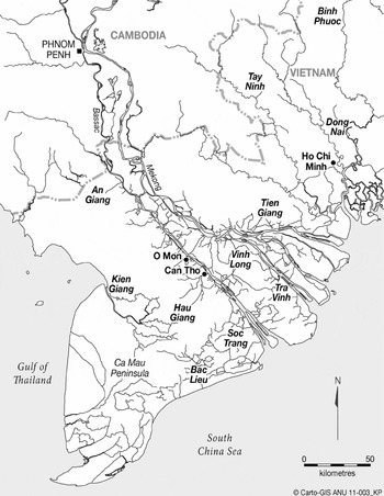
This paper describes the displacement of Khmer people from the rivers of O Mon, a district in Can Tho Province in Vietnam's Mekong delta (Figure 1). It relies on the oral testimony of elderly Khmer people such as Dao to relate a tale of modern day dispossession. Documenting the existence of a network of Khmer riverside villages in the prosperous heart of the Mekong delta, the paper challenges prevailing wisdom about the ethno-linguistic configuration of the lower Mekong basin. The displacement of entire Khmer communities from the waterways of the delta during Vietnam's wars of liberation raises new questions about the nature of these wars, and about whether indeed decolonization has yet run its course in Vietnam. The revelatory testimonies by Khmer Krom residents of O Mon offer new insights into the human ecology of the Mekong delta and suggest the need for a new history of the Vietnam Wars that incorporates the perspective of the indigenous people of this region.
Rivers of the Mekong Delta

Drawing on accounts from elderly people in the district of O Mon, I reconstruct a picture of life in the Khmer riverside villages of the central delta, circa 1940. Adopting a river-hugging settlement pattern that is prevalent in the Mekong delta, Khmer villagers in O Mon depended on rivers for needs ranging from domestic water consumption and agriculture, to transport and communal religious life. With a Theravada Buddhist temple as their focal point, the members of these settlements spoke and identified as Khmer. Although Khmer people in this region of freshwater rivers are now numerically overwhelmed by people who identify as Viets, the once markedly Khmer character of this region of rivers has been neglected in previous scholarship on this region.
These communities were among the most badly affected of all Khmer settlements in then Cochinchina by the events of the First Indochina War. Beginning early in the war, Khmers were expelled from their settlements, land-holdings were taken from them, and communities were dispersed. Large, long-standing and prosperous riverside Khmer communities disintegrated in a matter of years. The displacement of Khmer people from the waterways of the central delta continued into the Second Indochina War (1960–1975). In the subsequent three and a half decades of peace, efforts to regain land taken by newcomers during the wars came to no avail, while new factors from collectivization and decollectivizaton and private land markets eroded nearly all of what was left of Khmer tenure. The riverside settlements today are mere vestiges: their communities dispersed, their remnant populations poor and landless, their social and religious life atomized and anomic.
This paper is based on multiple field trips to the Khmer populated areas of southern Vietnam, beginning in 1999, in which I have mapped the cultural ecology and history of the Khmers of the region. Taking the district of O Mon as my primary example of the ecology and history of the freshwater region, I first reconstruct the way of life of the Khmer riverside settlements in the 1940s. I then describe the dislocations that befell the Khmer communities of O Mon in the period from 1945–1954 and which continue to affect the remnant populations up to the present. My account draws primarily on oral histories provided by elderly residents and is supplemented by ethnographic observations made during repeated visits to this locality over an 11-year period.
Excised from the waterways
Khmers historically have had a major presence in the Mekong delta. Home to the civilizations of Funan and Angkor, and lying within the territory of the modern nation-states of Cambodia and Vietnam, this multi-cultural region has one of the densest concentrations of waterways on the planet. The lower Mekong delta, today under Vietnamese administration, remains home to a large population of Khmer-speaking people, numbering approximately one and a half million.Footnote 3 However, scholarship reserves the rivers of this region for the most part to a variety of non-Khmer peoples.
French observers noted that at the turn of the twentieth century the ‘Annamites’ [ethnic Viets] in many parts of Cochinchina and Cambodia lived a semi nomadic existence in boats along the waterways.Footnote 4 The local pattern of building houses almost exclusively along the banks of waterways gave Vietnamese villages in this region an open character, which observers frequently contrast with the bounded, corporate village culture of the Vietnamese north.Footnote 5 The lower Mekong also has been described as a ‘water frontier,’ a conception which charts the waterways as a site for Chinese commercial networks and activities.Footnote 6 The notion of the Mekong delta as a ‘cosmopolitan periphery’ identifies the waterways of this region as home to Cham Muslim migration and settlement projects, Islam, and wide-ranging river-borne fabric trading networks.Footnote 7 A French ethnolinguistic map of the mid twentieth century shows this distribution: Chams and Malays living along much of the Mekong River, Vietnamese floating villages along the rivers and the great lake of Cambodia.Footnote 8
The centrality of rivers to these groups contrasts with the relationship to water reported for the Khmers. In David Chandler's reconstruction of the everyday social world of Cambodia in the nineteenth century, the Khmers typically are found in ‘rice-growing villages’ distributed at some remove from the major rivers, although interacting with riverside settlements for trade. These villages have as their centre the Buddhist wat and a pond or a stream as a water source.Footnote 9 Elsewhere he notes that ‘until very recently, most Khmer villages were isolated from the outside world and from each-other’.Footnote 10 He compares the villages with islands or ships, surrounded only by annually inundated rice fields.Footnote 11 The villages ‘are isolated from the larger towns which have government officials like police and tax collectors, not only because communications are poor, but also in many cases because the villagers want it this way’.Footnote 12 Riverside or kompong villages that extend in ribbons along the banks of navigable bodies of water were typically populated by people of different ethnicities: Chams, Malays, Chinese and Sino-Khmers. Kompong villagers engaged in trade and were open to the passage of people and news about the rest of the world. The largest of these river-port settlements, the capital city Phnom Penh, is described as majority Chinese.Footnote 13
Reports on the Khmers in the lower Mekong delta place them along the ancient coastal dunes of the southeast fringe of the delta or around the mountains near the Cambodian border. In observations that reflect a consensus view in French and Vietnamese scholarship, Brocheux writes that the ‘Khmers gathered in hamlets organized around a pagoda or Buddhist monastery [wat]. Many of these were located at the base of the nui [mountains] or the giong [sand dunes], where houses on pilings were surrounded by closed gardens that gave them a pleasant appearance’.Footnote 14 Numerous French and Vietnamese writers contrast the Khmer sand dune culture and preference for the high lands with a Viet riverine settlement pattern and preference for living along waterways.Footnote 15
Some have observed that this settlement pattern reflects a history of displacement. According to French writer Barrault, the dislocation of Khmers from the rivers of the delta commenced in the seventeenth century with the Vietnamese annexation of the easternmost regions of Cambodia:
Annamite immigrants ousted the Khmers, and replaced them along the banks of the watercourses, in the gardens and rice fields of the most fertile cantons. . .By 1700, the Cambodian territories of Saigon, Baria and Bien Hoa had been almost emptied of their rural Khmer occupants. . .The newcomers established themselves most numerously along the banks of the Bassac River and adjacent streams where they wasted no time in monopolising all the commerce. The Annamites occupied all the principal streams, then little by little the interior banks of navigable canals and forced the Cambodians to take refuge in the sand dunes.Footnote 16
By the time the French arrived in Vietnam, it is claimed, the colonization of the waterways by the Annamites was total. As Aymonier put it, setting the line adopted by subsequent foreign works on the Khmers in Vietnam: ‘[The Khmers of Cochinchina] found themselves confined to certain sandy hillocks of the delta of the great river, having conserved their language, their religion, their mores, their national costume, without mixing too much with the conquering people who encompassed them and pressed them on all sides’.Footnote 17
Post-colonial Vietnamese scholars have tended to elide pre-existing Khmer connections to the rivers of the lower delta, reinventing these features as indigenous Vietnamese living space. According to Vietnamese historians and geographers, the freshwater streams in the most ecologically favourable region of the lower delta were first opened for human settlement by migrants from present-day Central Vietnam.Footnote 18 Saigon, Bien Hoa and other adjacent areas are deemed similarly to have been unoccupied ‘wastelands’ (dat hoang) when Viet ‘pioneers’ arrived to claim them.Footnote 19 The ‘orchard civilization’ (van minh miet vuon), a unique adaptation to the freshwater rivers of the lower delta is claimed as a defining accomplishment of the Viet ethnic group. The historian Son Nam doubts that the Khmers ever settled the Miet Vuon region or partook of its distinctive orchard growing culture.Footnote 20
In the nineteenth and twentieth centuries, massive canal-digging projects extended and supplemented the natural rivers of the lower delta, creating conditions for the intensification of immigration and export rice agriculture. Khmers were largely absent in French histories of these developments. Governor Sarraut depicted the canal digging enterprise in western Cochinchina as a ‘Franco-Annamite collaboration’.Footnote 21 Subsequent foreign studies similarly treat the hydraulic transformation of the delta in the colonial era as primarily a French and Vietnamese project.Footnote 22 The Khmers who appear briefly in these accounts are victims, pushed aside by such hydraulic developments.Footnote 23
The waterways of the lower Mekong became a central theatre in the Vietnam Wars of 1945–1954 and 1960–1975. These conflicts conventionally are understood as wars of decolonization in which an indigenous force was ranged against a colonial regime in a struggle to regain independence for the country.Footnote 24 In former Cochinchina, this picture is complicated by the participation of numerous communist and non-communist organizations and localized religious groups, who also fought against each other in pursuit of their own frequently exclusivist visions of a post-colonial order.Footnote 25 Most of these contending forces had their strongholds in specific sectors of the waterways, such as the Binh Xuyen ‘river pirates’ of the Eastern delta, the Catholic militias of Ben Tre, the Viet Minh bases in the swampy forests, the Hoa Hao of the flood-prone western delta and the Cao Dao, French, and later Republic of Vietnam forces stationed in river ports and confluences.Footnote 26 These groups’ enmity towards each other and the territorially circumscribed nature of their control mean that the wars in Cochinchina are perhaps better understood as a multitude of wars for local pre-eminence rather than as a unitary conflict.
Missing from accounts of the Vietnam Wars are the words and deeds of those who might be regarded as the indigenous people of Southern Vietnam, the Khmers. Little is known about the involvement of Khmer people in the wars. The major war histories elide the topic altogether.Footnote 27 Works offering partial histories of the Khmers in these events contradictorily subsume the Khmers within the party's resistance struggle;Footnote 28 as generally supportive of the French presence in Cochinchina;Footnote 29 as hostile to the Vietnamese but wooed by the party;Footnote 30 or as loyal US Special Forces operatives.Footnote 31 Little is known about the wars’ effect on the Khmers or how they represent them. The extent to which Khmers identify with the wars as an anti-colonial struggle or consider their outcome as a victory or liberation are matters about which the historical record is silent.
In the post-war years, as Vietnam was drawn into a more peaceful and commercially-oriented re-engagement with the world, the waterways of the Mekong delta symbolized for many commentators the outward-looking and cosmopolitan qualities that would be required for Vietnam to achieve success in the new era. Rendered as a place of new beginnings, mobility, and intercultural exchanges they represent a way of life not tied to the village, or the past. Here emerged cai luong, the eclectic opera form that is said to symbolize the hybridity of southern Vietnamese cultural identity. The syncretic and universalist tendencies of the so-called ‘indigenous religions’, the Cao Dai and Hoa Hao, are thought by some to have been shaped by the communicatively open waterways from whence they sprang. As a site of economic innovation, agricultural productivity and commerce, the southern rivers have been seen as integral to modern Vietnam's economic renaissance.Footnote 32 To the extent that Khmers feature at all in these depictions it is as peripheral figures whose insularity, cultural particularism and remoteness from markets and transport conduits exclude them from the anticipated benefits of globalization.Footnote 33
In sum, scholars largely have ceded the rivers of the lower Mekong delta to a variety of non-Khmer actors. Khmers appear at best as marginal actors in histories of settlement, conflict and peacetime development along the waterways of this region. The inadequacy of such renditions is apparent if we look at census figures for Can Tho, a prosperous province in the heart of this region, where in 1901 resided in excess of 20,000 Khmers, or almost ten per cent of the population.Footnote 34 Little is known about how these Khmers related to the freshwater rivers that dominate this and neighbouring provinces. Nor is it known how these Khmers fared during and after the wars that tore apart Mekong delta society in the second half of the twentieth century. It is to these questions that this paper now turns.
The Khmer riverine culture of Bamboo River
Midway between the Vietnam-Cambodia border and the South China Sea, and stretching to the north and the south of the Bassac River, lies a region known to its Khmer residents as Prek Russey (Bamboo River). One of several discrete ecological zones inhabited by Khmer people in Vietnam, settlement patterns, livelihoods, communications, and religious practices in this region bear the imprint of its most distinctive natural feature, an extensive network of freshwater rivers. With an area of more than 2,000 square kilometres, the region encompasses the present-day provinces of Can Tho, Hau Giang and Vinh Long, and the western parts of Tra Vinh and Soc Trang provinces.Footnote 35 Despite its great size, only around 60 wat-based villages occupy this area, comprising approximately one-eighth of the actively identifying Khmer communities in Vietnam.
The defining feature of this region is its many interconnected prek, or small natural watercourses, that run perpendicular to the main channel of the Bassac River. The water in them is tidal, but it is fresh year-round. Opinion is divided as to the formation and function of these natural rivers. One early view was that they drain water into the Bassac from the swampy plains on either side of the main delta channel.Footnote 36 An alternative view is that they act as subsidiary distributaries of the Bassac, carrying excess water in the flood season through breaches in its banks.Footnote 37
A Khmer monk in Wat Polthisomron on the O Mon River provided a local perspective on how the river adjacent to his wat was formed:
Khmer people lived here in the distant past when the area was covered by swamps and forest. In those times, communications were not as developed as they are at present. The largest nearest watercourse was the Bassac River, known to the Khmer as Prek Russey. At that time the O Mon River didn't exist. It was instead a pathway used by elephants to walk through the forest. Water seeped into the meandering depression created by their feet until eventually the elephants had to abandon the path. They were replaced by freshwater crocodiles. Over time, the passage of crocodiles widened and deepened the watercourse, expanding the river to its present size. One day a man called O Mal came to the river and, finding it an ideal place to make a living, settled down. From that time the river took his name. It was later Vietnamized as O Mon.
The Khmers in this region live primarily along these natural watercourses.Footnote 38 Their houses sit atop the banks, aligned in ribbons along the bands of alluvium that have accreted on each side of the rivers. Since the banks are not of even elevation, settlement originally clustered in the high points. Until two generations ago, many houses were built on stilts. The position is favourable hydrologically, since elevation protects them year-round from rain-induced inundation and from all but the most severe floods. This part of the delta plain flooded annually to a moderate depth, less than in the border areas, but higher than in the coastal fringe. During heavy floods, the banks were the last points in the region to go under water and the first to emerge when the water subsided. At the same time, the riverside location provided households easy access to freshwater for domestic use and agriculture. Water drawn from the river until recently was consumed untreated, or boiled or settled in clay jars. This is the only Khmer settled area in Vietnam where drinkable surface water is available year-round.
A characteristic feature of Khmer livelihoods in this region is the cultivation of fruit trees, such as mangoes, bananas, pomelo, oranges and mandarins, which need year-round fresh water. Fruit trees are cultivated only on the riverbanks because prolonged immersion in water rots their trunks. Trees are planted in and around the household compounds, and to their rear, where the land begins to fall away.Footnote 39 Rice is grown on the periodically inundated lower land, away from the rivers. The soil is very fertile, since it receives regular deposits of alluvium. This region is one of the few parts of the Mekong delta that does not suffer from saline or acid soils. The traditional rice crop was seasonal rice (srauv rodauv) with a seven-month growing season. Sown at the onset of the rains, just after Chol Chnam Thmei (the Khmer New Year), the long-stemmed rice plants rose in tandem with the water level and were harvested after Ok Om Bok (the moon festival), once the floods had subsided.
The waterways also provide the basic transport infrastructure. They link houses within a settlement to each-other and connect people in this region to population centres and markets elsewhere. Many Khmer households still have a rowboat, moored to a small landing in front of the house. Until recently, the rivers were the sole means of transport. An elderly resident of the commune of Dinh Mon in O Mon described the scene in his youth in the 1940s:
At that time there were no roads, only narrow dirt paths. No bridges either, just some ‘monkey bridges’ of a single bamboo pole. Where there was no bridge you crossed the river on a raft of lashed banana tree trunks. Houses were right beside the river. Every household had its own boat. To go anywhere you had to travel by boat. I went each day to my rice fields, three kilometres downstream from here by paddling a wooden boat. Motor boats appeared on the river only in the 1960s, but in 1976 everyone reverted to paddling and sailing because of a shortage of fuel.
Another characteristic of this region is that all of its wats are located on rivers, which, in the past, was the only means of gaining access to them. The wats are on the highest land in each settlement. Most sit at the junction of two waterways. The front gate of each opens onto the river. The wats are connected to each-other by water in a network that gives the region an integrated character. As in other Khmer settlements, the wats are the focal point for Khmer communal life in Prek Russey with the main difference being that water provides the medium of connection between these institutions and the households that support them. Reminiscences about Dinh Mon in the 1940s recall the river as a site of localized religious travel:
The wats had their own boats and monks would conduct the alms round by boat, paddling from house to house. The monks sat in the front of the boat and a resident lay youth, or kmien wat, stood behind him, pushing the boat forward with wooden oars and striking a gong to announce their arrival at each house. People travelled to festivals by boat. Every wat had its own boat landing, either a walled dock, or a jetty.
Several of these boat landings are still in use to this day. The landing is sometimes covered, serving as a rest house for travellers, tha la, a feature one also sees near land-based wats. They are constructed by a layperson to make merit. Laypersons also build footbridges to help pedestrians across the small streams that flow into the main rivers.
Close by every wat is a busy river dock, rice mill, market or service centre, so even though some are still not accessible by road, one cannot call these institutions remote. Clearly this network of wat-based settlements, while distinctive and discrete, is not a closed network for it relies for integration on river routes, which also open up the settlements to the wider world. Today the waterways are busy with cargo craft that hail from various provinces in the delta and pass directly in front of people's houses. Recalling his youth in the 1940s, another elderly resident of Dinh Mon said:
Rice cargo boats were smaller than today. They were propelled along by people using paddles and poles. They would fly a special flag on the boat to indicate that they were buying rice and when those on the bank with rice to sell saw it they would wave the boat in. The rice traders were always Teo [ethnic Chinese]. The boat people were both Viet and Teo.
The combination of waterside residence, favourable water and soil conditions, a central location, and an all-weather transport network made conditions ripe for the Khmer to prosper. In the pre-war era there were several indicators of prosperity. One was land concentration. In the 1940s, when the average size of land holdings in the village of Dinh Mon was around five hectares, several wealthy families had up to one hundred hectares of land. A second index of wealth was the number of cows owned by a household, which were used to pull carts and to break up the soil prior to sowing. The third marker of differentiation was housing style. Only wealthier families had stilt houses. Poorer families built their houses on the ground.
Like elsewhere in the Theravada world, poorer members of the community utilized the wats as an avenue of social mobility. Each wat had its own monastic school. The curriculum, a combination of Buddhist and secular subjects, taught by monks and achars in the Khmer language, was identical to that of the reformed wat schools elsewhere in the Mekong delta and in Cambodia.Footnote 40 In the colonial period, Khmer children would continue studying at a Khmer and French language state school, undertake secondary studies in Can Tho (for instance at Phan Thanh Gian, the only Franco-Khmer secondary school in Cochinchina), or else go on to study in Phnom Penh. I spoke to an elderly man from a poor family in Dinh Mon, who is today regarded as being one of the most educated and knowledgeable people in his district:
Most people in my generation are literate in Khmer. We learnt it in the wat school, where lessons were in Khmer. Like my 83 year-old brother, I ordained as a monk. Like me, Khmer people from all over the delta studied in Can Tho. A primary education was very high standard. School was much better quality than today.
However, residence in such a favourable and strategic location at the heart of the delta brought great dangers. The majority of Khmer people living in the district of O Mon in the 1940s were displaced from their homes during the First Indochina War. Most have since been unable to reclaim their land. Several thousand Khmer families still live in the district and the wats are still functioning. However, only vestiges remain of O Mal's riverside Khmer communities, and my description of its once-vibrant water-based way of life has been reconstructed from my conversations with its elderly survivors. These conversations also reveal how the waterways were lost, a subject to which I devote the rest of this paper.
Areca River: a community displaced
In the late 1990s, I paid my first visit to Wat Phesachavonna on the banks of the Areca River (Prek Sala [Vietnamese: Rach Tra]), a tributary of the O Mon River, about two kilometres south of the O Mon district capital. Wooden freight boats plied the narrow river. Several had docked along its banks. A cement path wide enough only for motorcycles and pedestrians ran along the river bank through a densely populated residential area. The wat was surrounded by a sparse hedge. A state school building separated the wat from the river. I entered the grounds of the wat through a gap in the hedge, past an ancient-looking chedei, or stupa, whose brickwork was surrounded and penetrated by the roots of a tree. Footnote 41
Three elderly Khmer men were working on rebuilding the wat. They told me the wat had been built more than 500 years ago, but had been destroyed in 1945, during fierce fighting as the French had attempted to regain control after their loss of the delta to the Japanese and after the Vietnamese-led revolution. The only surviving structure from the original building is the chedei at the entrance, constructed in 1672. It had been protected from the fate affecting all other structures in the wat's precincts by the roots of the Bodhi tree which enveloped it. The elderly men said they had been told by their grandparents that the tree had been growing out of the chedei 150 years ago.
‘This wat was built long before there were any Vietnamese living here’, one of them said to me. ‘In the past, this area was called O Mal and belonged to Cambodia. All the land from Thu Dau Mot to Ca Mau, both of which are Vietnamese versions of Khmer place names, was formerly part of Cambodia, and was taken from us by the Vietnamese.’ One of the men interjected: ‘To say as much is to risk being thrown in prison.’ Another rejoined: ‘Yes, this is not something we dare to say freely but it is the true history of this land.’ The first continued:
The area to the north of Dong Nai belonged to the empire of Champa which is now no longer. The Vietnamese arranged a marriage between the Cham King and a Vietnamese woman and, after his death, seized the land of the Chams. Then they seized the land we call Kampuchea Krom. One of the towns in this region, Vietnamized as Bac Lieu, was the place that the Lao army encamped when requested by the Khmer king to come to its defence against the Vietnamese. The Khmers lost their struggle against the Vietnamese and fled Vietnamese troops. When peace was restored and they returned, their land had been seized.
I asked him what he knew of the history of this area.
In the past, Khmers owned the land in this district. We grew bananas, grapefruit, mangoes, rambutan and rice. The population was very sparse: nothing like you see today. The situation around 100 years ago was that the Khmers were the landowners and the Vietnamese worked for us. Now, the Vietnamese own all the land. Nothing is left in Khmer hands except our wats. Former Khmer residents work as labourers for Vietnamese bosses. They no longer even live here. They are now concentrated in the market area along the highway. Did you see the porters working in the market with darkish skin? They are Khmers, the original owners of the land around here. Now portering is the only living available to them.
I asked: ‘So what do you make of the story the Vietnamese tell of coming and settling deserted lands several hundred years ago? ‘It is not true’, his neighbour replied.
Another of the men spoke:
I am now sixty years old. Fifty years ago, there was abundant land in this area and the Khmers lived here and made a living from our rice fields and orchards. During the Viet Minh's war with France, the fighting was intense. The Khmers were forced to flee. When peace was restored and we returned, we found Vietnamese had occupied our land and we were unable to regain it. That is the only truth to the story of Vietnamese settlement of deserted land.
His companion, the oldest of the three, silenced him: ‘Drop it. Don't cause trouble for yourself’. He turned to me. ‘Please understand and sympathize. If the government hears what you have just heard, we are done for. Don't tell anyone what you have heard here.’
Another came at the issue from another angle:
During the Viet Minh's war with France, the Khmers who lived here were in an impossible situation. The Viet Minh controlled the area by night. During the day, when the French troops came, anyone found living here was suspect. They rounded the residents up and concentrated them in the market area [of O Mon district capital] and in Co Do district capital.Footnote 42 If they came back to work their fields by day, they were attacked by the Viet Minh as co-operating with the French. It was no longer safe to remain here day or night. The Viet Minh seized their land and distributed it to the Vietnamese who co-operated with them.
His elaboration was again met with nervous commentary by the oldest of the Khmer laymen not to repeat a word of what I had heard. Their companion continued: ‘The Khmers and their wats were also attacked by the Hoa Hao troops, who supported neither side but wanted independence for themselves. They stole from wats and seized personal possessions of Khmer people’.Footnote 43
I asked about the destruction of the wat. One of them said that the area had been heavily bombed in 1945. ‘It was war. Nothing was spared, neither life, property, nor cultural heritage.’
On occasions of fierce fighting, relics such as the chedei had routinely been used by both sides as gun defences and had invariably incurred damage. The road passable to four-wheel vehicles that used to run along this bank had collapsed into the river.
We passed onto more recent events. The wat was reconstructed just after the French war in 1955. It was restored by community contributions even though by then many of the laypeople affiliated to it no longer lived in the area. The grounds, now at 1.6 hectares, are just over half their original size. The diminished area lacks a protective wall. A tiny rice field produces rice for the needs of its small novice population. In the late 1950s, the wat resumed its functions of teaching, ritual care for the dead, and hosting festivals. After 1975, restrictions were placed on making contributions to the wat. Khmer language books were confiscated, teaching activities restricted and the travel of monastics was curtailed. Now, they agreed, the position of the Khmers is a lot more tolerable. Government policy towards religious activities of the Khmers had eased in 1985–1986. However, with the dispersal and impoverishment of the laypersons affiliated to this pagoda these changes could do little for the health of this wat-based community.
These elders despaired that Vietnam's Khmer population was in the process of losing its cultural memory. They said that only the older generation, who had the chance to read and study about their history, can preserve their identity and it is only through oral means of transmission that the young can learn the truth about who they are. Wats remain the key site for this process and elders spend much time transmitting their knowledge to novice monks. These elderly men were to be found in the wat, engaged in restoration work whenever circumstances allowed. The work had been underway for only the last few years using money contributed by the lay community.
Life for the majority of Khmers in Vietnam is extremely arduous. We work in the morning, earning just enough to by rice for a meal. We return to work in the afternoon to earn the cost of the evening's meal. Although savings are extremely hard to come by, somehow money is still found to advance the restoration of pagodas. It is a matter of cultural survival, no less.
One of the men delivered a concluding speech to me:
For me, a member of the Khmer Krom people, who was born here and whose ancestors, to my knowledge, have always lived here, it is with great regret that I cannot receive you in the capacity of owner of my own country, but that my country is forced to endure being under the rule of another. I cannot say for sure when, if ever, we will regain self rule—when my people will be able to control their destiny. Our present plight is a cause for great regret on my part. If there is anything you can do to help my people, I would ask that you please try to do so.
‘Enough, enough, one step at a time’, one of the company broke in. He turned to me:
Please think about our conversation and share it with people in your country which allows freedom of speech. I just ask that you keep our conversation from the Vietnamese government. Everything said here, if they found out, would land us in prison. There are things that every Khmer knows, but dare not speak aloud. It is only because you come from far away that we tell you our thoughts. So please sympathize with our situation and remain silent until you leave Vietnam.
This encounter with a group of elderly men in O Mon in the late 1990s remains one of the most troubling I have experienced while conducting research in Vietnam, not just for the terror that infused it, but for its many explosive revelations. It made me aware that the dispossession of the Khmers from their lands in Vietnam occurred not just in the distant past, but has taken place during the lifetimes of Khmer people alive today. When Khmer Krom people speak of having lost Cambodia, they refer not to abstract geopolitical realignments alone, but to the displacement from specific localities of Khmer communities. Indeed, it would appear that the anguish felt by this group of elderly Khmer men about the loss of their country is deeply coloured by local events of the recent past. Equally it suggested to me that Khmer people in O Mon have been robbed of their voices. They are unable to tell their story and continue to live in fear of the consequences of doing so.
Many elements of this story challenge official depictions of the Khmer and their position within the modern nation-state of Vietnam. Existing explanations of poverty and landlessness among the Khmer ethnic minority cite factors such as remoteness, lack of education, a maladaptive culture, exploitation at the hands of a commercial minority, or a negative psychology.Footnote 44 To these factors might be added what was alleged to have occurred in O Mon: the terrorizing of Khmer people and theft of their lands. The Khmers have not always been poor and landless peasants, indeed many in O Mon reportedly were once well-off landowners who have had their land taken from them. In this account, the land thieves include Viet Minh forces and ethnic Vietnamese sectarian troops. Very directly, this story challenges depictions of the French war as the struggle of an indigenous people to regain control of their land. Instead, it is described as a contest between rival occupying armies in a traditionally Khmer locality, whose eventual outcome was the dispossession and impoverishment of its indigenous people.
Weighed down with the serious implications of these revelations, I did not share these views with others, for fear of endangering the safety of my interlocutors. For the same reason, nor did I return for several years to O Mon. Instead, I travelled widely in the Khmer areas of southern Vietnam in an attempt to put these views into some context. I heard many stories of the loss of lands, destruction of pagodas and dispersal of Khmer communities during the war years and after. I encountered pent-up anger at the failure to redress these injustices, combined with crippling fear of relating the barest outlines of history. Everywhere I found that narratives about the loss of Cambodia were infused by the events in local communities in the recent past.
However, I also found a great deal of variety in the history of various localities and it was my realization of the complexity of the history of dispossession and a desire to follow up the specifics of the case of O Mon that brought me back to Wat Phesachavonna by the Areca River four years later.
Return to Areca River
The appearance of the wat was unchanged since my first visit, its structures still dilapidated, its grounds almost deserted. Three elderly women were eating rice in the grounds of the wat and they waved me over. The oldest was 70 years old. She said she had lived in the wat since her mother died. She had never married because she was too preoccupied with looking after her mother.Footnote 45
She said that in the past, the wat had been surrounded by an entirely Khmer population:
At that time the Khmers living here were, for the most part, wealthy. An average family might have five to eight hectares of land. A wealthy family even more. They lived in stilt houses because the area flooded annually, less so over time as more canals were dug to absorb the flood waters.
Early in the century, the main rice crop grown was floating rice. It was harvested in the second month of the lunar calendar. It was sown at the beginning of the rainy season before the waters began to rise. During the rainy season, people travelled around by boat, visiting each other in their houses. In the three rainy-season months the monks were required to stay in their wat. When the rainy season retreat was over there would be a big festival in the wat and in the evening a large paper tower would be floated down the river. Three days later came the festival of kathin, in which the monks were presented with the new robes and people would feast on cakes of sticky rice. Many farmers sold their rice surplus. Some bought and sold rice as a professional occupation. The Khmer people also grew mangos and could produce up to several tonnes per family, enough to sell in the market.
The old woman continued:
During the war with France the Khmers in this locality lost everything. It was not the French who took their land but the Vietnamese. They moved in during the fighting and bullied the Khmer into leaving. Anyone who resisted had their throats slit. Entire families died in this way. The people responsible for this were the Hoa Hao. The fighting between the two sides was fierce, shells flying overhead both ways across the river where their settlement was located. I remember hiding in an underground shelter during the fiercest exchanges. Eventually all the Khmers abandoned their houses and fields and fled to the marketplace. When the war was over they came back and tried to eject those who had occupied their land but were unsuccessful. To this day we have been unable to gain redress and the wat is entirely surrounded by Vietnamese families.
Another of the women told me that the Khmers who lived here were once well-off, even rich:
But now, it has to be said, we have all become poor. Now, most work as porters in the market, a few get by as petty traders, selling fruit or driving a motorcycle taxi. Few have land. Most are illiterate. We don't have the education, any kind of knowledge in our heads to use to make a better living.
The youngest women declared:
If you want to see the consequences of that conflict, way back in 1946, look no further than me. In my family there are three generations of illiterate people. When my parents were forced to move away, they were left with no means to support me and my brothers and sisters through school. My three children are also illiterate, for me and my husband have been unable to earn enough money to put them through school. That is what dispossession from one's land can do to a people.
Four years later I again returned to Wat Phesachavonna, a visit that deepened my sense of the extent and the consequences of the dispersal of this community.
The preah vihear, or main worship hall, was still in a state of disrepair. It had not been painted or renovated in any substantial way since my first visit here, eight years earlier. The roof tiles still needed replacing. The floor was covered in dust. No murals depicting the Buddha's life history adorned the interior walls. The Buddha statues on the altar were dowdy and faded. The koti, or monks’ residence, was in deteriorating condition. Work had begun on a new monks’ residence but the work had halted owing to a lack of funds. A large chedei housing the remains of former abbots was crumbling and covered in moss.Footnote 46
I was told by a layman who was working in the grounds that in his youth the grounds had many large trees that attracted a great variety of birds. The previous abbot, who had a habit of bathing in the river with his pet turtle, knew all the names of these birds. Now there are no birds at all. Most of the trees, which take at least 30 years to grow to a usable size, have been cut down. The large state school building occupies land that used to belong to the wat. The school is attended by children from the local area. None of them are Khmer, since there are no Khmer people left living near the pagoda.
The three elderly men with whom I had spoken on my first visit were not to be seen. Later, I learnt that these men had passed away. Two of the elderly women I had spoken with previously were busy sweeping the paths. But I learnt later that they too had passed on. As with previous visits, no saffron-clad figure stepped out of the monks’ residence to greet me. Once again, no monks were to be seen.
My guide on this visit was a middle-aged layman. He was about 25 years younger than the men I had initially met. He told me that the preah vihear is in such poor condition for a number of reasons.
First, there is no-one here to organize its renovation. Just seven monks are registered to the wat, some of them not originally from this area. Five are away studying. One of them has disrobed. The others may never return. Only two elderly monks are in residence, including the abbot. One, aged 70, is sick and weak. He ordained ten years ago because he was infirm.
These two were asleep in their quarters during my morning-long visit, old, sick, and disengaged from events outside.
Another reason the preah vihear is in such a state is that the renovation costs so much. A preah vihear—even a small one like this—costs 100,000 USD minimum to build, not counting the greater proportion of the labour, which is normally voluntary. A little overseas Khmer money has trickled in here and there. But most Khmers from this area are poor. Maybe only 20 per cent are doing reasonably well, those who have a small piece of land somewhere. But most own no land. The main job around here is portering, carrying loads in the O Mon market. Many make a living by cutting rice on other people's land.
Finally, there is no-one around here to take care of the wat. About 150 families are still affiliated to this wat. They come here just once or twice a year for the festivals. But people have scattered elsewhere to make a living, many families have moved.
The layman gave me his own account of the disintegration of the wat-based community, confirming much of what the elderly people had told me, and reporting recent developments:
It is true, as the old people told you, that in the 1940s, this area was almost entirely Khmer. Now the situation has reversed and the area around Rach Tra is entirely Viet. The majority of people who live around the wat have nothing to do with it, except for sending their children to the government school that occupies its grounds. Many of them followed the outsiders during the war. By that I mean the VC, the present rulers. Some of them also followed the insiders, the Republic of Vietnam.
In the past, in the time of my elders, many Khmer people lived here. Some had large holdings of land. However, they lost their land and left for a variety of reasons. Some had their land taken from them during the French war. The majority of Khmer here followed the French, that is what my elders told me. Few followed the Viet Minh. I do not know why. They just answered the call to support the French when it went out. When they lost, many Khmer people went to live in Cambodia, where it was peaceful, abandoning their houses and land. Others abandoned their land during the fighting; many never came back.
After the French war, the remaining Khmer landowners lost their land in stages. First, the larger holdings were subdivided and part was redistributed to poorer people. Then, for several years after 1975, the land was put under a collective. The land was pooled. Seed and fertilizer were provided by the collective and rice had to be given back to the collective: it could not be sold privately. The collective was a failure. When it was disbanded, land was given back to private owners, but many Khmer people could not master the formalities to regain ownership of the land that they or their parents once owned. Finally, owing to the difficult conditions of making a living in recent years, many Khmer people sold their land to others to meet costs and pay debts.
He described these recent land sales as ‘legitimate’ transactions.
Today no Khmer people live nearby the wat. The nearest are two or three families in the predominantly Viet neighbourhood where I live, 1.5 kilometres from here. I have to ride my bicycle to get here each day. Several families live up by the O Mon market. Some are in Can Tho and Saigon. One or two families live overseas. Some of them have never returned. The people who still support the wat live in Thoi Lai,Footnote 47 Co Do, Dinh Mon, O Mon or further away. They are former residents who scattered to establish new settlements. The wats there are newer than Wat Phesachavonna. There used to be more Khmer people living around Rach Tra than around any of these other wats.
He said that the monks no longer conduct the alms round as they did in the past. ‘Aside from being old and sick, they have too far to go. It is more than one kilometre to the nearest Khmer household and the others are even father away.’ Aside from the two elderly monks, on a typical day the occupants of the wat comprise just three laypersons, himself and the two elderly women who cook food for the monks. As mentioned, one of them lived in the wat itself.
He describes a process of dissolution spanning several generations, of a Khmer community thinning out, its members fleeing their homes, individual households losing their land in successive steps, until all that is left are some families scattered far from what was formerly a largely Khmer locality. Elderly members of the settlement's diasporic community return to tend the wat although its monastic community is weak or absent. Different waves of Viet people have infiltrated the area, surrounding the wat, acquiring the land, their language and institutions becoming dominant. The wat itself is a remnant, deriving no support from the adjacent community, its grounds subject to incursions by new neighbours whose children attend the state school but with no connection to the institution or to those who founded it.
One remarkable exception to the desolation afflicting this wat is the care invested by individual families in private chedeis within its grounds. These come in a great variety of shapes, sizes, colours and decorative styles. Many are old and unpainted, including the large chedei housing the remains of previous abbots. But even the small private chedeis, some untouched for 30 or more years, have very distinctive shapes and colours. One large and impressive chedei was finished just a month ago. Another, almost six metres high, was under construction. During my visit, three workmen were decorating it with ornate cement bas relief blocks created from clay moulds. The style of the chedei resembles the Cambodian Independence monument on Norodom Boulevard, Phnom Penh.
A workman was affixing the cement bas relief decorations to the chedei and smoothing them with an electrical stone grinder. He told me he was building the chedei to inter the members of his family. His family lives up by the O Mon market. They were originally from here. He had also built his own house. ‘Making a chedei is much harder than a house, because it has to be built faithfully, according to the traditional style, unlike houses, which are constructed according to modern fashions.’ He said a chedei like the one he was building cost 1,500 USD.
The middle-aged layman pointed to one chedei that had been built with funds sent back from a family member in America. ‘This is the only chedei built with overseas money. The recently-constructed one was built with local funds. Another was built by a Viet woman in Saigon. She is actually the daughter of a Viet-Khmer marriage.’ He said she comes back here several times a year to visit the place where her ancestors’ remains are deposited: ‘her origins are from this area, so she always returns’.
I learnt that the ancient root-entwined brick chedei at the entrance to the wat is a collective depository for the dead, such as one finds in most Khmer wats, where the practice of collective entombment is standard practice. A former resident monk told me that it is full of the cremated remains of previous generations of locals: ‘There are so many remains in the chedei that its contents would fill two rice sacks.’ However, unlike in other wats, it is no longer in use. ‘Now former residents tend to build private chedeis for their family members. They place the remains of those who have died in these, rather than in the collective chedei.’
The only other new structure in the vicinity of Wat Phesachavonna is a crematorium, just beside its grounds. The middle-aged layman told me that the crematorium had been built two years ago. It had cost 100 million VND (6,000 USD), some donated by an overseas family and the government had donated 10 millions, ten per cent of its cost.Footnote 48 The crematorium is used by neighbouring families as well. The crematorium has a commemorative plaque and a sign in Vietnamese outlining the regulations to be followed. A cement rest house stands next to this for families to make preparations. A large image of the Buddha is painted on the rear wall of the rest house. He is sitting at the foot of the Himalayas with deer grazing in the pasture.
In Wat Phesachavonna, the emphasis is on the dead, more so than on the living, and on bereavements within families rather than within the community, which no longer exists. The monastery has become a diasporic cemetery. Communal connections to the wat have been effectively severed, including those between the communities of the living and the dead. The main continuing attachments to the wat are those maintained by individual families, who come to tend the stupas where their ancestors’ remains are deposited. These are atomized linkages that do not represent a community. Instead, they lead to the incongruous proliferation of family stupas in excellent condition in the grounds of a wat whose main buildings are in dereliction.
Dinh Mon: a community in vestiges
Four kilometres south of Areca River, is the commune of Dinh Mon. It stretches about seven kilometres along the Vam Nhon River, a meandering freshwater stream that flows east from the O Mon River, averaging eight metres wide. Numerous smaller streams feed into the Vam Nhon, each of which is crossed by a precarious wooden bridge. Three Khmer wats lie along its banks, Wat Nery Vone, Wat Serey Vongsa and Wat Ampiwon. They are equally spaced along the stream, positioned on natural confluences. Vam Nhon is divided by some local Kmers into three sectors, upper, middle and lower Vam Nhon, each with its own wat. Others describe the stretches of the stream as Vam Nhon proper (in the vicinity of Wat Nery Vone), Peam Cang (where Wat Serey Vongsa stands), and Proh Bei Salah or ‘lower’ Vam Nhon (where Wat Ampiwon stands). These Khmer place names are unknown to the majority of the present-day residents of the commune. Only a thin scattering of Khmer people still live along the stream, concentrated in small clusters beside each wat. They are the last vestiges of a vibrant network of Khmer communities that once lined the rivers of this district.
I spoke to an elderly man born in Dinh Mon in 1934. He gave me a lively account of life in his youth, interrupted every few minutes by the explosive phutt-phutting engines of bulky cargo boats making their way past us on the waterway.
The land around the O Mon River formerly was entirely Khmer. This was still the case when I was a boy in the early 1940s. I know what I am talking about because as a boy I used to accompany the monks everywhere they went. We visited all of the wats and Khmer settlements in this region, travelling by boat. All the wats were connected by water; it was very easy for monks and laypersons to get from one to another. Each wat had its own landing platform and dock for boats.
We undertook the alms round by boat, going from house to house by paddling along the river. All of the houses were on the riverside. Most houses were on stilts. You don't see these any more. The houses were made of wood and thnaot sugar palm leaves. Only poor people like my family lived in houses on the ground.
People grew rice and fruit—pretty much the same as is grown today. An average Khmer family had several hectares of cropland. Wealthier families had 20–30 hectares or more. The poorest family had just a hectare or two. These days you are doing well if you have one-tenth of that. Many have nothing but the land their house is [built] on and, thanks to government assistance, their house is of concrete. But some like my own family do not even have land for a house—we have lost everything.
In those days, people did not use money much. They obtained goods on credit and paid for them in rice. The storekeepers were Teo. So were the people in the market centres. Viet people did not know how to do business until the war ended. Like the Viet, Khmer people did not know how to trade. All we knew was farming—production. People of my generation are literate in Khmer we studied it at school in the wat.
After Liberation, life became much more difficult for the Khmers in O Mon. We lost our land, homes, and wats; we became poor and illiterate. In fact, the decline began during the war when the current crop of leaders—in those days they were called the Viet Minh—began to organize resistance against the return of the French to Vietnam after the Japanese surrender. The Khmers mainly followed the French. For this, many Khmers were targeted by Viet Minh forces. Our houses were burnt down. My relative died because he was unable to escape from his house in time. Many people were killed.
By 1946, life in most Khmer neighbourhoods in the district became impossible. If we stayed in our houses and villages we would die—either from Viet Minh attacks or French counter-attacks. Therefore, many people fled to congregate in O Mon town, abandoning our houses and land to save ourselves. There was a French garrison there. It was relatively safe. Others moved to Thoi Lai. That had been a relatively uninhabited area but the French had a garrison there so Khmers from here moved and set up a new settlement under French protection. Wat Thoi Lai was built in 1947. It is the most recent wat in the district. Wherever Khmer people go they must have a wat, so it was necessary to build one.
The other great danger for Khmer people during the war was the Hoa Hao. They lived nearby in Thot Not and in An Giang and Dong Thap. They followed the French because they hated the communists and a lot of killing went on between those two sides. But the Hoa Hao hated the Khmers even more than the Viet Minh hated the Khmers. The reason for this was that they knew the land they were on belonged to the Khmers. So they wanted to eliminate us. The Hoa Hao are all Viets. Hoa Hao troops came and attacked Khmer people in our villages and even those in O Mon town. Six members of my brother's family were killed by the Hoa Hao—picked off one by one when they were out fishing, taking rice to the market or staying at home. Khmers who remained in their homes were under attack from three sides—the Viet Minh, the French and the Hoa Hao.
‘So did people return to their homes during the ‘six years of peace’ in 1954–1960?’ I asked.
No, we were still very scared of being killed. The people who had threatened us during the French war—the Viet Minh—had remained in place. And they had seized our land and houses. Even if we did return we could not reclaim our property. People were living in our houses or had rebuilt a house in the same location. Some original residents did return but they had to build a new house on another part of their property. When the next war broke out the area again became a guerrilla-controlled area and it was again very dangerous to stay at home. In fact, most of the original residents of Dinh Mon and neighbouring Khmer villages, myself included, never even returned to our homes after the war. We remained in O Mon town as there was nothing left to return to.Footnote 49
I paid several visits to Dinh Mon, stopping first at Wat Nery Vone on a three-way river intersection. A solid brick and concrete wall seals the riverbank along its front. Recessed into it are a boat ramp and flight of stairs leading to the river. The wat is more functional than Wat Phesachavonna, but is extremely modest in comparison with those in the provinces of Tra Vinh and Soc Trang. A few small buildings are squeezed into its grounds. The monks living quarters are simple and small as is a solitary classroom with wooden walls. The preah vihear is supported by bare concrete posts. One faded picture adorns its walls. Five or six demountable cots occupy most of its interior space. No laypersons were in the grounds when I visited in 2007. However, 16 young monks were in residence, most of them visitors. They were studying Year 2 in the monastic curriculum, supported in part by local families and funds raised by abbots from other wats in the province.
Beside Wat Nery Vone is a phum, a cluster of Khmer households belonging to an extended family. The phum is made up of five households and runs alongside the river. The five houses are owned respectively by three elderly siblings, the child of one of them, and that person's child. Each house has a wooden landing and a small wooden rowboat in front of it. Three of the five houses are solid and in good condition, of brick, tile and cement. One has palm leaf walls and an iron roof. The house of the oldest resident, a 70 year-old man, is of brick with a fibre cement roof. He was lying in a hammock on his front porch when I first met him. He told me he was born there. His wife is deceased. Her remains and those of his parents are deposited in the wat. He shares his house with his grand-daughter.
He said that 200 Khmer families live in the commune of Dinh Mon. Forty Khmer families live in proximity to this wat and support it. The 750-metre stretch of the riverbank from the main road to the wat is all Viet. Then comes this phum, then another string of Viet households, with the remaining Khmer families scattered in small phum along the river bank. Around the other two wats, further downstream, Khmer and Viet people live interspersed, with less clustering of Khmer families than here. He said that Wat Nery Vone is the oldest of the wats on this river.
He told me a now familiar story about the history of the Vam Nhon settlements:
No Viet lived along this river in the early 1940s when I was a boy. We can say that it was entirely Khmer. There were several big landowners then—Khmer landowners. They had properties from 50–100 hectares. The biggest landowner was Hoan Duc, who was also the village headman. Hoan Duc's father was the next biggest landowner. Five or six families had fields in excess of 50 hectares. They used animals to till the fields. They had hired labourers working for them and some also rented land to tenant farmers. Tenant farmers paid 25 bushels of rice each year in rent. They made more than that in one harvest alone and had use of the land for the remainder of the year. I was from a poor family. I owned only two hectares of land.
In 1945 Khmer people left this area for O Mon. I know of the killings by the Hoa Hao troops during the war. I know the family that lost six members. But the Hoa Hao were not much of a problem because Hoan Duc was much stronger in this area than they. The reason we left is that in 1945 the French bombed the Viet Minh forces operating in this area. It was impossible to live here then. The French offered people protection from the fighting and from the Viet Minh in three locations where French garrisons were stationed, O Mon market, Thoi Lai and Wat Ampiwon. So all the Khmer left this area. I went to O Mon, like most others from this settlement. Some never returned. When the others came back, they found that Viet people had moved into their land.
By 1950 my family could return to Dinh Mon, but not to here, it was too dangerous. Instead we moved to the vicinity of Wat Ampiwon, about six kilometres downstream from here. I stayed there for ten years until the next war broke out in the late 1950s. My grandparents’ remains are deposited in Wat Ampiwon. I return twice a year for Chol Chnam Thmei and Bon Dolta. You must return every year to your origins, where your grandparents are enshrined.
I joined the army of the RVN [Republic of Vietnam] around 1960. Ten years later I was demobilized when my right index finger was shot off. In 1970 I returned here to Wat Nery Vone to live and grow rice. Those were peaceful times in this area—there was no military activity until 1972–1973 when the Viet Cong again became active. But although Viet Cong and Republican troops clashed I felt safe living here because everyone in this area knew me. But I had only half the land that I had owned before. I gave away 0.3 hectares of my rice fields to my brother, who had lost all of his. The rest of my land had been taken by a Viet family—newcomers. The policy of the Viet Cong was to share out the land to everyone. They called this policy chia com se ao [share the rice, divide the clothes].
In 1986, despite the policy to return land to the former owners, I got back just 0.2 of the 0.7 hectares that I had lost. Many got nothing back. It depended on the strength of your case. You had to have the original land title papers from the French era to have any chance at all. Fortunately I had these. And it helped if your family followed the revolution or lost lives in the process. But even then you could get back only a small proportion of your land. I fought for the Republic, but was demobilized well before the peace, so my case was not as bad as it might have been. But being Khmer was the weakest position of all. Viet people had a clear advantage in the land reclamation process.
He said the worst post-war year was 1979 when there was nothing to eat. Surviving the lean years, he put his children through both monastic and state education:
I have four sons. They all ordained as monks, some for seven years. I ordained too, but only for two years. Only three of the sixteen monks in this pagoda are from the local area, including one of my grandsons. One of my sons, now disrobed, teaches Pali to the monks. He is very good, much more knowledgeable than me. I put all of my sons through the state school system. The cost of uniforms, books, food, fees and supplementary costs was very high. It was extremely hard to come up with the money.
‘They graduated year twelve, but still work as rice farmers’, he said, ruefully.
Soon after that, my wife got sick with a disease that blinded her. I had to take her up to Saigon several times for treatment. Each trip cost several hundred US dollars. And I had to pay for all the drugs which were very expensive. But she died anyway, two years ago.
I asked where the money for these health and education expenses came from. This is a man with just one hectare of rice fields, three kilometres away. He said he sometimes borrowed but paid off all his costs and interest by doing extra manual labour. ‘I never sold my land. It is what I rely on for subsistence.’ I admired his tenacity. He has had enormous costs but has kept the same amount of land that he had 20 years ago. Now he relies on his children for support. ‘In truth, I am worn out now. I am so weak I dare not do any kind of heavy labour.’Footnote 50
Travelling downstream through Dinh Mon, billboards announce campaigns to eliminate social vices, and build a moral, cultural society. All public signage in the commune is in Vietnamese: most of its present-day residents can speak no other language. The river is busy with boats and lined with houses and a variety of small businesses. Dinh Mon resembles many places elsewhere in O Mon district, and in the provinces of Can Tho, Hau Giang, Vinh Long, and Tien Giang, with its excellent land fed by a lacework of fresh waterways that serve as a site of residence, irrigation and transport. Like these places, Dinh Mon seems to typify the southern Vietnamese miet vuon orchard civilization. Indeed, in the minds of many of its residents, it has never been anything other than Vietnamese.
Wat Serey Vongsa is on a riverine threeways about four kilometres downstream from Nery Vone. The structures are small and in poor condition. The grounds are also small. Several Khmer families live near the wat along the smaller creek. I met a Khmer man who was fixing a boat engine and a woman who was drying rice in the pagoda grounds. Only one monk was in residence, 40 or 50 years old. I did not see him on either of my visits.
I asked the Khmer man the Khmer name for the creek. He scratched his head for a while. An inquisitive Viet neighbour who had wandered up from a small beer bar 50 metres down the creek chided him loudly: ‘You've been here more than ten years and still do not know the name!’ She said it is called Rach Tra An. The area is called Tra An Three-ways (Nga Ba Tra An). She said she is from Tien Giang and had been here since 1987. Her husband is from elsewhere in O Mon and came here after 1975.
The Khmer man finally remembered the Khmer name for the creek, which he said was Peam Cang.Footnote 51 It used to be much narrower than it is today. Over time, the wake from boats has eroded the banks, widening the creek significantly and making it easier to navigate. There is little water flow here as it is a midway point between tidal flows.
The Viet woman said she knew just a little Khmer. I tested her. She knew nothing. I chided her. ‘You have been here more than ten years and still don't know one word of Khmer!’ She said, ‘No-one will teach it to me. My neighbours won't teach me and there are no classes in this pagoda.’ ‘Only in Wat Nery Vone’, said the Khmer woman.
I had a similar interaction at the next river intersection downstream, beside a cluster of shops across from Wat Ampiwon. I spoke to a young man, sitting in a café with some other youths in anticipation of a Sunday afternoon of cockfighting. To my eyes, both he and his sister looked Khmer, with wavy hair and skin darker than their neighbours. But they said emphatically that they were Viet, not Khmer, and knew no Khmer language. The young man said he had not once set foot inside the Khmer wat. He did not know its name. He said Viet people here are mostly Roman Catholics. ‘The Khmer people are Buddhists. The chua [wat] on the other side of the river is for them. Each sticks to his own side.’
I asked them the name of the settlement. They said Nga Tu Nha Tho (Church Intersection). The church is just down the road. I pointed to the Khmer wat, right on the confluence, and asked why it is not called ‘Wat Intersection’. Another young man explained that the church was here first: ‘It has been here for hundreds of years. It was here in French times, and even before. The pagoda came only later’. A 79 year-old man confirmed that the church was already here when he was young, although it was smaller then. What about the wat, I asked him. ‘A long time. It was already here in the time of my great-grandfather.’ The young people exchanged thoughtful glances. The old man said he did not know which had come first.
I spoke to a few elderly Khmer people in a small riverside phum next to Wat Ampiwon. The preah vihear had been freshly rebuilt, but it was small, unpainted and undecorated. The tiny grounds of the wat were full of slender trees. ‘This wat is hundreds of years old’, they said. ‘It is the oldest of the three wats on the Vam Nhon River. However, it was destroyed in the war.’ They said the American war was much worse in Wat Ampiwon than elsewhere. From 1967–1970 the former safe haven was heavily bombed. ‘The fire from napalm bombs was so fierce it would destroy a whole house instantly. If you dig into the ground the bombs are still burning to this day. There was not a house left standing in the area.’ They said people only returned to rebuild after 1975. Today only 30 households are affiliated to this pagoda, but in reality it is supported by just four: those whose houses are close by the pagoda. There is only one monk, who was working in the rice fields when I visited. He does not undertake the alms round.Footnote 52
Wat Polthisomron: a place of refuge
Many of the refugees from Rach Tra and Dinh Mon resettled around Wat Polthisomron, next to the O Mon market, on the O Mon River. Although the grounds of the wat are small, wedged between the river and the town centre, it served as a safe haven from the fighting that raged in the surrounding district during the First and Second Indochina wars. There I met an elderly man who had fled from Dinh Mon in 1946. He told me that Wat Polthisomron itself originally had been in a different site and had been relocated, long ago, when a wave of new migrants arrived on the scene.
Wat Polthisomron was founded four hundred years ago, maybe earlier. But it was in a different location, about three kilometres down the O Mon River, near its junction with the Bassac—the big river (prek thong). Two hundred years ago, Viet people started settling in that area. My grandparents told me that Khmer people did not like living crowded alongside those people. When Viet people settled in that area, the Khmers abandoned their land and wat and moved further up the O Mon River to re-establish their wat here.
His account was confirmed by senior monks in Wat Polthisomron. The Pali teacher told me that in fact the wat had been relocated twice. In both cases the relocation had been forcible, precipitated by violence involving outside groups.
This wat was originally located in an elevated region in Thoi An (a commune by the Bassac River). In the 1800s, conflicts occurred between members of the Buu Son Ky Huong faith, the antecedents of the Hoa Hao religion, and the Khmer community of Thoi An, which forced the Khmers to relocate to the site of present-day O Mon market where they reconstructed the wat. Later, O Mon market was occupied by the Japanese army. During a battle, village residences were torched and the fire spread to the wat, which was burnt to the ground. The wat was forced to move for a second time, to its present location. By that time, the population of the local area had already built up, so the amount of land available for the wat was quite restricted.
Entangled with memories of the more recent past, these accounts offer a sense of the violence and dislocation upon which Khmer communities in this district have been founded. Theirs is a precipitous, unstable history in which people displaced by war found refuge in a place said itself to have been repeatedly displaced in violent conflicts. These ancient dislocations involved antagonists such as the Buu Son Ky Huong, the precursors of those alleged to have displaced the Khmers in more recent wars. Destabilizing as this was, the story was far from over. With peace ostensibly established in 1975, the Khmer community around Wat Polthisomron entered an unsettling new phase.
I asked a 35 year-old resident monk if, in the past, Khmer people had owned land in the area around the town of O Mon. He said that right through Republican times, until 1975, the Khmer people living here all had owned land. The average landholding had been two to three hectares. The poorest families had owned .07 hectares of land. The richest families owned up to 20 hectares. At least one landowner in each hamlet of the district had owned in excess of ten hectares. They were considered large landlords by the standards of northern Vietnam, although their holdings were average compared with others in the south, and small by international standards, with low returns from non-intensive farming methods.
However, this changed after 1975. In 1982, under Party Secretary Le Duan, the government instituted a collectivization policy (chinh sac hop tac xa). This policy abolished private property holdings and all lands were incorporated under collectively-managed bodies that determined the use to which land and labour would be put and the amount which farmers would receive in remuneration. Under the co-operatives, each family was allotted an area of land they would farm, although their use of it was determined by the co-operative management. By this stage, the population of O Mon town had grown considerably, swollen not only by war refugees from the district, but by many landless migrants from elsewhere in Vietnam who had arrived after the war. The limited farm land available for collective production was divided up between former residents and these new arrivals alike.
This policy continued until Party Secretary Nguyen Van Linh's accession to power. The decollectivization policy he inaugurated returned land to the owners and aimed to increase production by allowing individual decision-making with respect to their own property. In the process, even once-landless newcomers received the area they had farmed under the collective, land which formerly had been owned by Khmer people. In 1992 the newcomers also received a certificate which recognized them as the owners of that land.
For this monk, together the collectivization and decollectivization policies amounted to an act of officially sanctioned expropriation. In his estimate, one half of the land of the Khmer residents of the town was taken from them by the government in this two-step process. The larger landholders lost almost all their land. The majority, being average-sized landholders, lost half their land. This was the case for his family. Prior to 1975 his family had owned 2.3 hectares of land by the town gates. In 1982, 1.2 hectares was given to an ethnic Viet family. In 1992 only 0.2 hectares of that was returned to his family when their ownership rights were recognized by the government. Like almost all the local Khmers, his family is still waiting fruitlessly for the return of land they consider to be theirs. They lack any kind of documentation to prove that they originally owned the land, although this is known by all the members of the original Khmer community. He said the Viet owners can offer as proof of their claim to their land the certificates issued by the state in 1992.
The elderly Khmer man who had fled to O Mon from Dinh Mon during the 1940s confirmed what the monk had told me:
After the war, the area around the town was collectivized. When the collectives were disbanded in the early 1990s, the land was redistributed, supposedly to its original owners, however, only a fraction of their former property was ever returned to the Khmers.
When the town was developed by the state in the mid-1980s a new wave of Viet people came to live here. The biggest influx was between 1983 and 1987, when the town's street grid and the market centre were developed. People came in from everywhere to settle and do business. ‘Up until that time,’ the elderly man said, ‘O Mon was little more than a market and had only a few Viet residents. Today the Khmers are a minority in the town. Most of the Khmer town residents have no land, only a small house.’ The abbot of Wat Polthisomron said until very recently, the area of the town along the O Mon River was populated exclusively by Khmers. ‘Very few Viet people lived there. Now they comprise the vast majority.’
Since the early 1990s, the economy of the areas surrounding O Mon has grown at a break-neck rate. Nearby Can Tho City has expanded rapidly, with large infrastructure projects, an expanded service sector, and mushrooming private residences and small businesses. Next to O Mon, enormous processing factories have sprung up in the industrial zone of Tra Noc. The road west to the Cambodian border has been widened and improved almost beyond recognition with many of the wooden leaf-roof stilt houses that lined it in the early 1990s cleared to make room for the road. New roadside houses, warehouses and commercial establishments have eaten into the rice fields and fruit orchards. A rapid increase in the number of store houses and processing facilities represents a shift away from primary agricultural commodity production to value-adding economic activities concentrated almost exclusively along the roads. At the same time, there has been an explosion in the consumption of imported goods, including housing materials, clothing, foodstuffs and vehicles. The district is moving beyond primary produce dependency into higher level industry, service provision and trading, while becoming more dependent upon the importation of status and convenience goods produced beyond the region. These are the local results of the reform and open-door policies.
For many of the residents of O Mon district, by contrast, these policies have not led to an increase in their economic standing. Most of its people struggle to make a living from small agricultural holdings, from rice, grapefruit, bananas and livestock. Very few can make enough from agriculture to save and improve their livelihoods. Most live day to day on agriculture and wage labour.
For O Mon's Khmer residents, the situation is even grimmer. The 35 year-old monk told me that now the wealthiest Khmer family in the district capital might own one hectare of land, which would have qualified them as the poorest in the district before 1975. Only a few Khmer households are to be found along the main road that cuts through the town, among a great preponderance of Vietnamese and Chinese. The monk estimated that 65 per cent of the Khmer were very poor. By this he said they were landless, making virtually all their living from wage labour, which, in 2002 earned them around 1.50 USD per day, but only when they could get the work. The demand for wage labour in a small rural town such as this is only slight and sporadic. For most of the Khmers in O Mon, investing in a new enterprise, or conducting business, considered the best means of improving one's fortunes in the local area, are beyond reach.
His house is on the road to Can Tho, about three kilometres from the O Mon market, just outside the district capital gates and beyond a fringe of illegal ‘hugging bars’ full of young women dislocated from poor farming families from all over the delta. Altogether about 100 Khmer families live here among pockets of ethnic Viet residents. Most of the houses are small with dirt floors. They are made of melaleuca (tea tree) poles and the walls and roofs are covered with thatched water coconut palm fronds. The houses are laid out like ethnic Viet houses, with a large front room, which serves as a guest room, bedroom, dining room and ritual space. The poorer families have no furniture apart from a bed or two, a plastic chair or wooden stool, and a wardrobe or chest to store clothes and valuables. Most of the houses occupy very small plots of land and are arrayed side by side between the road and a ditch that runs parallel to the road about ten metres back. Behind the houses are rice fields, although many of the families do not own these. Many own a small plot of rice fields about 700 metres back from the road. They have to walk through fields owned by others to get there.
The monk's 64 year-old mother said that in her youth, the entire area in which they were living was predominantly owned by Khmer people—perhaps in excess of 70 per cent of the residents and landowners were Khmers. She said that most had left the area, many retreating to the hamlet one kilometre back behind the road, others elsewhere. I asked in what circumstances the Khmers had disappeared from the local area. She said it had begun in the mid 1950s when the foreign aggressors had invaded the country.
I asked her if they had been forced to flee because of the war. Her son replied in the negative, saying that his people had been forced to sell their land due to economic hardship. He said that people sold their land whenever they needed money. In between harvests this was often the only way to get money to send a child to school, pay for medical treatment and to make debt repayments. The latter was the main factor leading to landlessness. The four-month rice cycle meant that by the time the income from the harvest came in, most of it had already been used to repay debts contracted for fertilizer and pesticide, as well as food, clothing, and other living expenses. Many attempted to reduce costs by withdrawing their children from school and resorting to hunting and gathering. However, not long into the crop season, most families found that they had to take out new loans. Interest of five per cent for small loans and higher for larger loans had to be paid on a monthly basis. As people sank deeper into debt, selling off a parcel of land became the only way to acquit debts and generate some cash to survive the inter-harvest period. Landlessness was especially pronounced among families missing a parent or with a seriously ill member. When people were sick they made purchases of pharmaceuticals from a retail outlet. Only in cases of extreme sickness might they seek professional medical treatment from a hospital-based doctor because the high costs of doing so meant that they would have to sell their land.Footnote 53
Conclusion
The findings reported for the district of O Mon add dark new hues to our understanding of the Indochina wars, officially represented as an anti-colonial struggle and as wars for national independence. According to the official history, cessation of the wars returned control of the country to its indigenous peoples and ushered in a new era of security, prosperity and openness. Yet the case of O Mon reveals that these events are widely seen to have had the opposite effect. The wars displaced the original inhabitants of the district, dispossessed them of their land and scattered communities. Long-standing connections with land and communal institutions were severed, leaving the survivors atomized, landless, destitute and uneducated. This process of dispossession did not conclude with the end of the wars in Vietnam but has continued up to the present moment. Many of the advances celebrated for the Vietnamese nation since 1945—decolonization, liberation, collective mastery, economic liberalization, urbanization and industrialization—have had adverse consequences for the Khmer people of this district, severing their connections to their land and to each other and driving them further into poverty and despair.
According to some Khmer locals, Khmers have been losing territory for a very long time. An elderly man living just across the Bassac River in Vinh Long Province observed to me: ‘In the past, this land was part of Cambodia. Gradually the Vietnamese came and pushed, pushed, pushed the Khmers out of their way. How could we resist, with no position or power?’ As a consequence, he thought no Khmer wats were left north of the Mekong River in the provinces of Long An, Tien Giang, Dong Thap or Tay Ninh and only a handful were left in Vinh Long. As Khmer people had left these areas, the wats had been destroyed or had deteriorated. In some of these places, the odd koki tree or stand of sugar palms are the last surviving vestiges of Khmer habitation.Footnote 54
Yet when the Khmer people of this region talk about losing their country, as they frequently do, they are talking not only about dimly remembered events of the eighteenth and nineteenth centuries, but about events that occurred within living memory, about events that are ongoing. When my interlocutors in O Mon told me that land once belonging to Cambodia had been taken by the Vietnamese, they were speaking about events taking place in a geographically intimate sphere, about the fate of families, neighbours and wat-based communities whose members had been uprooted and scattered. When these Khmer people spoke about the broad sweep of regional history, the driving factors they emphasized are those with which they are personally familiar, affecting their own families and taking place in their own lifetimes. Their recollections of once entirely Khmer communities being uprooted by outsiders and ethnic others are doubtless simplified, tinged by exclusivist sentiments and full of ellipses. These oral histories of conflict and loss need to be supplemented by a wider range of sources for a fuller understanding of local history to emerge. Yet retelling them here, for the first time, contributes a crucial perspective to the history of this locality that cannot be obtained in any other way.
Today, the district of O Mon is almost indistinguishable from similar districts in Vinh Long, Tien Giang, Ben Tre, Can Tho and Hau Giang. This fertile area is home to a thriving fruit and rice growing economy and a spectrum of hyperactive small businesses. At the time of research it was undergoing a profound shift from a water-based way of life towards one based on terrestrial infrastructure and industries. It is a region where today Vietnamese is the predominant language and Vietnamese cultural institutions and memories are dominant. It is typical of the miet vuon area celebrated as a defining cultural accomplishment of the Viet people of southern Vietnam. If one speaks with the people residing in these areas some will profess that their locality has always been part of the land of Vietnam, others that Khmer people are to be found only in Cambodia, or in Vietnam's geographical margins. However, if one speaks to the elderly people in O Mon's few small and mostly decrepit Khmer wats, one hears that within living memory it was in fact predominantly Khmer.
As the recollections of the elderly people of O Mon reveal, this region of fresh water rivers was, until recently, a place of concentrated Khmer settlement. Khmer people utilized the freshwater streams as a source of fresh water and lived along their banks to keep above the high waters. They made elegant use of the complex water conditions, cultivating fruit trees above the flood level on the fertile soil of river banks, and growing seasonal rice in the floodplain. Khmer settlements followed the waterways and were interconnected by water. People travelled to each-others houses and to their fields by boat and sold their produce to traders who accessed the region by boat. Their wats were located almost uniquely along rivers, at important confluences and were integrated into the social and religious life of the community by water. The wat-based communities of O Mal were integrated with Khmer-speaking communities elsewhere in the Mekong delta, and beyond, making them thriving cultural and economic centres at the heart of one of the most prosperous and strategic locations in Southwest Indochina.
The freshwater river region of the lower Mekong delta extends well beyond O Mon district and includes much of the provinces of Can Tho, Hau Giang, Vinh Long, Ben Tre, Tien Giang and Long An. Most of the extant wat-based Khmer communities of this region lie along natural waterways. It is a large, fascinating and to date almost entirely unknown sub-region within the larger Khmer-speaking culture area. By considering the adaptations to freshwater rivers forged by the Khmers of this region, appreciation of the diversity of the Khmer ecological repertoire is significantly enlarged.
However, just as this unique Khmer settlement zone expands understanding of Khmer cultural accomplishments, its recent history also shows where Khmer culture has been at its most vulnerable. The economic and cultural prosperity of Khmer settlements owed much to their location in this fertile, well-watered and well-integrated region but it also placed them at the heart of struggles for territorial dominance between stronger competing forces. Ousted during some of the fiercest conflicts of the twentieth century, they have been unable in a time of peace to secure recognition for their claims to the houses, fields and water access they have lost. Within the freshwater region, the tragic fate of wat-based communities in O Mon is similar to that befalling Khmer villages elsewhere in Can Tho, Hau Giang and western Vinh Long provinces, almost all of whose Khmer residents were displaced by the wars. While Khmer settlements along the eastern fringe of the freshwater river region are in marginally better shape, they too have been affected by war-era land appropriations, the disintegration of tight-knit settlements, the erosion of communal institutions and impoverishment and landlessness caused by more recent socio-economic changes.
The freshwater river region was not the only Khmer populated area of the Mekong delta of Vietnam to be affected by the wars and their aftermath. In the high, dry lands of Binh Phuoc and Tay Ninh, along the Cambodian border, many Khmer communities that were in situ in the 1950s have vanished, and those that remain are vestigial. The Khmer presence remains somewhat stronger in the oceanside settlements of Kien Giang Province and the mountainside villages of An Giang Province, although the latter subsequently were devastated during the Vietnam-Cambodian border war of the late 1970s. Khmer communities have fared best in the delta's populous eastern coastal strip: in the politically and culturally redoubtable Tra Vinh Province, and the commercially vibrant provinces of Soc Trang and Bac Lieu.
The nearest kin to the Khmer freshwater river settlements, with regard to ecological adaptations, are the approximately 100 Khmer villages that line the seasonally saltwater rivers of the Ca Mau Peninsula, in Kien Giang, Ca Mau, Soc Trang and Bac Lieu provinces. To this day an extensive network of riverside settlements survives on the peninsula, whose bustling river-based activities, unlike those found elsewhere in the Khmer-speaking world, are reminiscent of the central delta of times past. However, owing to the devastating impact on the peninsula of the US war, massive war-era population transfers and tumultuous post-war reforms, the Khmer identity of the saltwater river settlements is precarious. Their residents face loss of access to land and water, economic and environmental crisis, the withering of monastic populations, abandonment of the alms round and the monastic curriculum, and near universal loss of Khmer literacy.
The stories related by the people of O Mon illustrate the centrality of rivers in the Khmer history of the lower Mekong, just as they demonstrate how tenuous the Khmer presence along these natural features has become. The disintegration of a host of unique Khmer riverside communities during the Indochina wars and their aftermath not only affected thousands of families, it altered the social and cultural landscape of the lower delta. These stories are retold here in the hope that Vietnam's authorities, its citizens and their international counterparts might better appreciate this region's Khmer heritage and history and defend what remains of the distinctive cultural character of this Khmer-populated region. Assessing and compensating the Khmers of this region for the material and cultural damage they have suffered surely will be more difficult steps, for the hard-fought incorporation of this region of rivers into the ambit of the modern Vietnamese nation has indeed come at a painful cost.