

IntroductionFootnote 1
Throughout the ‘Abbasid caliphate, the northern portions of the African continent played a critical role in supporting the empire. The whole of the Maghreb rested securely within the empire bounds, and the majority of civilians participated as fully fledged Muslims dedicated to the economic, militaristic, and religious practices of Muslims in the ‘Abbasid core in Baghdad.Footnote 2 Even with the ‘Abbasid caliphate reaching across North Africa, Muslims around the whole of the ‘Abbasid empire lived with a decapitated knowledge of what rested southward on the African continent. Even North Africans knew very little of the people and cultures within the interiors of Africa, and imaginings of what lurked south of the Maghreb consequently became full of extraordinary and misguided legends.
Despite increasing efforts to decolonize recitations of world history, the notion of Orientalism has become the widely accepted defining mark used to reference the encounters between outsiders and Africans. Yet within this focus on Western encounters, the ways in which other cultures and people thought of the world and then came upon and built relationships with each other can get lost in the shuffle and historically marginalized. In the case of the Middle East, Lewis has nicely worked to rectify assumptions that racial relations in the region represented any type of utopia.Footnote 3 Adding to such efforts, we work to further illustrate that although people have known that the Earth was round for a long time, this does not necessarily mean that people carried a clear understanding of what took place and who lived in unexplored regions of the world, nor were understandings of boundaries of the African continent reflective of reality.
Many of the perceptions that Middle Eastern cultures had of the “outside world” rested not in experience, but total rumor and imaginations run wild. For example, according to the well-known Greco-Roman mathematician, geographer, and astronomer Ptolemy, the Earth was spherical, with half being the known Afro-Eurasian landmass and accompanying bodies of water. The other half, including Africa, represented a hellish “anti-world.” This area was a scorching, uninhabitable realm where the rules that governed the natural world did not apply. The term “al-Wāq-Wāq,” in fact, came to represent to some nothing more than an anthropomorphic tree that rested in forbidden areas, which created a monstrous breed of half-human and half-vegetable creatures that lived in unexplored territories including both Asia and Africa.Footnote 4 In the case of Africa, interestingly, Ptolemy did not think that Africa had an end, but rather that the most southern landmass in the world circled the globe as a band that met back up with northern Africa.Footnote 5 Tying together Greek and Muslim schools of thought, the twelfth century philosophical tale of Ḥayy ibn Yaqẓān additionally elucidates on the preventive barriers between the worlds that lie beyond the Orient and Occident explaining that, “no one can reach there or force a passage save the Elect among the mass of men, those who have gained a strength that does not originally belong to man by right of nature.”Footnote 6
This article sets out to explore the methodology in map making that led to extreme discrepancy in how scholars during the ‘Abbasid caliphate viewed the southern lands where black, Sub-Saharan Africans lived and the geographic thought that accompanied their understanding. Although, as we will show, scholarship exists that expounds on cartographic practices during the ‘Abbasid caliphate, we aim to combine sources with an inclusion of pre-Islamic influences in map-making, all while solely considering how Africa south of the Sahara became so distorted during the ‘Abbasid era. To do so, we consider particularly how the interior of Africa came to be viewed by the ‘Abbasids considering the concept of the al-Wāq-Wāq alongside map-making. Wāq means “protected” in Arabic, and during the ‘Abbasid caliphate the term “al-Wāq-Wāq” was used in application to the southernmost parts of Africa, especially around the modern states of Kenya, Mozambique, and South Africa. We will explore how geographers, especially the schools of al-Mas̒ūdī and al-Balkhī, relayed a knowledge of Sub-Saharan Africa’s interior as protected or shielded from humankind, and that the region was a dark and mysterious place. In doing so, we will also show that owing to the incorporation of Greek bodies of knowledge by scholars in the ‘Abbasid empire, the train of thought evoked by ‘Abbasid geographers was heavily influenced by and reminiscent of the classical Greek perception of the world.
Before delving into how al-Wāq-Wāq became to be what it was during the ‘Abbasid caliphate, it stands significant to mention that the manner in which geographers drew al-Wāq-Wāq varied slightly by virtually every geographer, even when there are very clear lines of transmission of information and scholarship. For example, even the most cohesive lineages of cartographic schools, which will be explored later in this article, had variations from one cartographer to the next. This article provides discourse as to why there was such a significant disparity with how Africa, an integral part of the Islamic world since the seventh century, was depicted during the ‘Abbasid caliphate. We contend that the peculiar depiction of al-Wāq-Wāq was deliberately strange and attempting to convey a mythical lack of knowledge about the region and its people.
In order to achieve this multiplicity of goals, we show that the factors that lead to this error were quite complex and not confined to one field of scholarship. We show that mathematical errors contributed to the way that features were plotted with coordinates, but also that communication issues and dismissive stereotyping also stood between those who observed or explored the region themselves and those who wished to characterize it academically. Such characterizations and preconceptions led to cultural clashes and a lack of engagement with the southern African populace, commonly referred to in ‘Abbasid scholarship as the “Zanj,” a common term in Persian and Arabic used throughout the ‘Abbasid Caliphate to describe black Africans, particularly in the hinterlands and beyond the southern coastal of the trade network. In the early centuries of the ‘Abbasid caliphate Zanj revolts across the Middle East especially became a problem for Middle Eastern Muslim leaders. For example, in 870 CE black soldiers sacked the Persian harbor town of ‘Abbadān. Such revolts led leaders to keep a special eye on Zanj, especially by ensuring that blacks were only imported into the region as subjugated slaves. Muslim hostility grew, we show, throughout the ‘Abbasid era into an unfavorable image of black Africans, which could have contributed to the seeming disinterest in accurately depicting the African continent accurately in maps in comparison to regions like South Asia.Footnote 7 As shown throughout this article, ‘Abbasid scholars carried much of the same stereotypical and racist ideas about black Africans that carried into the colonial era and beyond, especially a focus on the nudity, paganism, and cannibalism that marked life in the interior of Sub-Saharan African life.Footnote 8 The sections of this article work to build on each other to show the way that these factors amplified each other, yielding a perception shrouded in dubious validity, even at the height of ‘Abbasid intellectualism.
To achieve these goals, this article is divided into four sections before offering a conclusion. In section one, we review geographic traditions across the Middle East and the Mediterranean in order to show how Bedouīn navigational methods impacted views of their world. In doing so, we consider how pre-Islamic navigational methods alongside the way that the Bedouīn, Persians, and Greeks envisioned the world factored into navigation and cartography during the ‘Abbasid era. Section two then turns to consider the various uses that maps held for the ‘Abbasids. From here, the third section reviews Arab trade and why knowledge of African geography was important for Muslims beyond sheer scholarly understanding. Lastly, section four, reviews the prominent lineages of scholarship in the ‘Abbasid era and traces how and why their techniques and maps varied from one another.
Islamic Geographic Traditions in Arabia, the Middle East, and the Mediterranean
In order to understand the deformation of Sub-Saharan Africa’s borders in maps during the ‘Abbasid caliphate it is first important to consider the manifold influences that played into geographic scholarship preceding the era. In this section, we consider how Bedouīn, Persian, and Greek systems of navigation and cartography each came to influence the perceptions of the southern hemisphere. To begin, we start with the Bedouīn, a nomadic people prominent across the Arabian Peninsula that naturally stands as one of the most influential groups throughout Middle Eastern history. The root of their name, al-Bedū, is especially apt, meaning “the original” in Arabic. By the time of the establishment of Islam, the Bedouīn had already become legendary for their bravery in battle, self-sufficiency, livestock prowess, and, most visibly, their manner of dress. It is fitting, then, that “the originals” would possess great navigational skill without the aid of the magnetic compass, long-range communication, and even the most fundamentally modern navigation tool – the map.
In terms of an informed geographic record, cartography was absent as a way of understanding the world in the pre-Islamic Middle East. Even still, there were several methods with which geographers and laypersons alike represented the world, ranging from integrated meteorological and geographic techniques of the Bedouīn to ethno-political “spheres of influence,” taken from Persian geographers, far predating the Western use of the term. The Bedouīn heavily favored mnemonic techniques for envisioning the lay of the land. One legend, for example, held that the Earth’s landmass roughly resembled a bird. To the east, the bird’s head represented China. The lower wing represented India, the upper wing for the Caucasus region (al-Khazar) and Europe, and North Africa and the Horn represented the tail. Unsurprisingly, the Middle East and Persia represented by the body.Footnote 9 Sub-Saharan Africa becomes noticeably absent from this model, a region with which Middle Easterners had practically no contact with prior to the spread of Islam.
In terms of navigation, it stands to reason that the Bedouīn likely had a fairly advanced knowledge of the relationship between astronomical and planispheric mapping given the lack of documentation about any mathematical basis for their methods. The Bedouīn likely used a heuristic system of evaluating the positions of constellations, weather patterns, and season to determine the best route to take. The constellations, which naturally have their own mythological names and tales attached to them as in the Western tradition, likely served as one of the most critical elements of fixing one’s current location and orientation.Footnote 10 For the Bedouīn in particular, successful land navigation became the hallmark of one’s true humanity, self-sufficiency, and maturity. Historically, the Bedouīn have acted as nomadic pastoralists and trade brokers between distant cities. Accordingly, their livelihood depended on the ability to find the most efficient path through the desert while also occasionally tracking lost livestock in adverse conditions. It was imperative that an adult male, in particular, could understand and predict patterns and changes in the climate and environment around him. As such, using this “integrated” system of meteorology, astronomy, and geography would require a well-rounded knowledge of where deserts, mountain ranges and suitable grazing land were in Arabia and the Middle East, the distances between these features, and their approximate size.
Thus, the Bedouīn had a strong sense of what one could call relative geography, or knowledge of where things were in relation to each other. At its core, relative geography is fairly intuitive and practical. An understanding of relative geography can be acquired without studying supporting reference material or mathematical techniques. In the case of the Bedouīn, because their knowledge of geography, meteorology, and astronomy was strong enough to adequately support their nomadic lifestyle, there would likely have been little impetus for Bedouīn to advance it any further.Footnote 11
Persians, however, had a much better-informed geographic tradition in terms of the body of their knowledge prior to the advent of Islam, though decidedly less mimetic in nature. One of the most important holdovers from the pre-Islamic era that spans into the ‘Abbasid caliphate was the kishvar system. The kishvar system is a concept map that relates the different realms of the world in terms of what people groups share land, connected by certain memorable geographic features such as the Kashmir valley or Mediterranean Sea. In such maps, the world is divided into seven kishvars, with Persia at the center. These maps and the kishvar system in general served Persian rulers in determining distance between other kingdoms and their distance outside of the Persian territory.Footnote 12 Notably present in this model is al-Sūdān, or Sub-Saharan Africa, grouped with the horn of Africa. On first glance, it is peculiar that Persian geographers took note of sub-Saharan Africa, while the Bedouīn did not pay much mind to it, despite it being significantly geographically further from Persia than Arabia. This stems partly from the difference in purpose between the two geographic traditions. To the Bedouīn, the only geography that mattered was that which was pertinent and related to sustenance. The ruling Persian elite, on the other hand, had a greater interest in understanding the geopolitical relationships between areas under their control and neighboring states. The kishvar system heavily influenced how ‘Abbasid geographers envisioned and grouped different parts of the world geopolitically. It is frequently referenced in the written geographies of scholars such as Abū al-Rayḥān al-Bīrūnī, and when describing foreign regions geographers often followed the same grouping patterns of the kishvar map. These geographical groupings were furthermore used outside of simply describing the Earth’s known landmass, and permeated how different people groups, religions or languages were understood and documented.Footnote 13
The Greek astronomer Ptolemy stands as perhaps the strongest single influence on intellectual efforts in Islamic cartography. During Abū al-̒Abbas al-Ma’mūn’s administrate (r. 813–833 CE), al-Ma’mūn patronized the translation of classical scholarship with a special interest in astronomy. ‘Abbasid mathematicians quickly gravitated towards the advanced geometry of Ptolemy’s work in planispheric and cosmological mapping. Scholars found Ptolemy’s writings on astronomy so profound that his inheritors even in mythologized him in ‘Abbasid folklore. One legend, for example, states that Ptolemy invented the astrolabe when he was carrying a globe projection of the constellations and dropped it from horseback, whereupon it was trampled underfoot. When Ptolemy retrieved it, it had been crushed into a disk, taking on the conventional form of an astrolabe.Footnote 14
Ptolemy closely associated his astronomic and geographic findings, as presented in his work Geographia. Here Ptolemy sets forth some of the fundamental principles underlying ‘Abbasid and later cartographic traditions. More specifically, Ptolemy makes use of a rectangular coordinate grid system alongside a spherical projection of the Earth. After the translation of Geographia into Arabic in the mid-ninth century, these features would come signal the most obvious manifestation of the Ptolemic tradition in ‘Abbasid maps. Another important aspect of Ptolemy’s geography is his description of climates or climes. In the Greek tradition, climes refer to latitude ranges wherein the meteorological environment is similar and asserts that locations on the same latitude will have the same weather and terrestrial attributes. Geologically, this is a reasonable rule of thumb; for example, Casablanca in Morocco and San Diego, California have remarkably similar climates despite being on different land masses, due largely to weather patterns driven by their similar distance from the equator. Ptolemy characterized seven climes, describing the Mediterranean as the most arable and livable, and the other climes further north or south being progressively less suited for civilization. ‘Abbasid scholars transliterated climes as qālim, the same word used to describe the Persian kishvars. As a result, discerning which system is at hand when reading Islamic geographic scholarship from this period can be difficult.Footnote 15 Ptolemy’s maps included a projection of Africa as a peninsula jutting far out into the Indian Ocean, connecting to Southeast Asia. This defect, referred to as “the Unknown Region” (Arḑ al-Wāq-Wāq), is copied into many maps drawn by ‘Abbasid cartographers in the Ptolemic style. Although centuries of time and great geographic space separated the ‘Abbasids from Ptolemy and his signature error, as ‘Abbasid rulers increasingly found a necessity for maps, Ptolemy’s influence carried on in how Sub-Saharan Africa became depicted.Footnote 16
Early Uses for Maps in the Caliphate Period
As previously established, the Bedouīn lived and worked by their skilled navigators and geographers in their native lands. However, the spread of Islam carried them much further from the Arabian Peninsula. Bedouīn soldiers, along with other Middle Eastern Muslims during the life of the Prophet, advanced rapidly from Arabia across North Africa, Anatolia, Persia, and beyond. Accordingly, Arabs in the subsequent Umayyad and ‘Abbasid caliphates had to develop new techniques for understanding and navigating the unfamiliar terrain and territory they encountered. This section works to address the advent of the map for military and political purposes, as well as the later integration of maps into common geography and literature.
While early Arab Muslims had a fairly robust understanding of the physical and political geography of the Middle East, their mnemonic techniques proved inadequate for transmitting knowledge about the rapidly expanding frontiers of the Muslim world. Written or oral descriptions of northwestern Africa, Persia, and Anatolia proved ineffective in aiding government officials and caliphs in understanding the region in which their military forces were operating. As such, a practice of sketching regional maps for military purposes developed early in the Umayyad and then ‘Abbasid periods. Depictions of regions, often paired with a verbal description, would be sent via messenger to regional or central rulers with a report of the tactical and strategic situation.Footnote 17
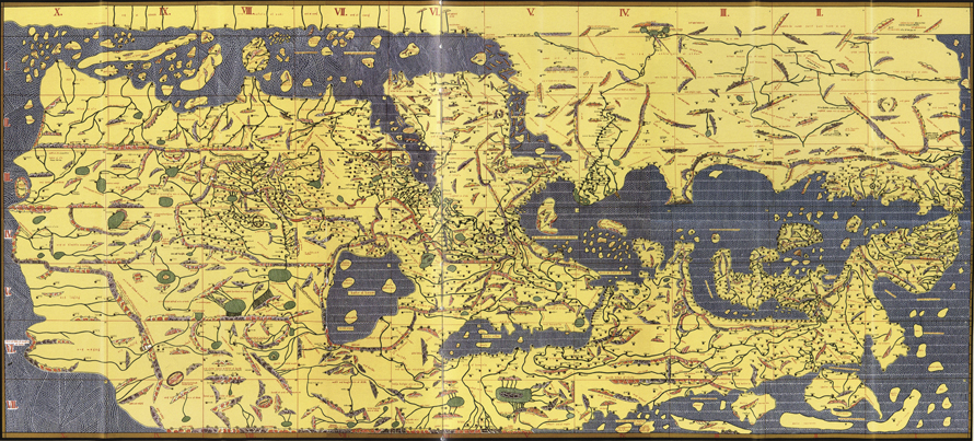
As time went on, scholars began incorporating sketches of maps into their written geographies. Typically these were small regional maps to display the shape and location of important features such as rivers and coastlines. In this sense, maps were not their own form of communication; they were sparse and difficult to interpret without the text they supported.Footnote 18 At the height of ‘Abbasid rule, running from the ninth through eleventh centuries, cartography developed as a form of art for the ruling class. The most famous example of this is the legendary “map of Ma’mūn,” commissioned by the caliph in the early ninth century, and is perhaps the most famous example of aristocratic interest in maps. Described by al-Mas̒ūdī as one of the most accurate and comprehensive world maps to date, this map was intended as a mural to show the extent of his empire.Footnote 19 Later, King Roger II of Sicily (1095–1154 CE) commissioned al-Idrīsī to make a similar world map, which survives to this day. Both of these maps evidently drew heavily from the Ptolemic tradition, with feature locations based on coordinates and the telltale “Unknown Region.”Footnote 20 Especially in the case of these world maps, their mimetic nature, which typically yields a rectangular map based on the way coordinates were used, becomes a hallmark of their quality and rarity.
Konrad Miller’s Reference Miller1928 reproduction of the Charta [Tabula] Rogeriana, originally published in 1154 by al-Idrīsī.Footnote 21 The map was drawn “South up,” a trait also observed occasionally in the al-Balkhī school. Copyright: Image is now public domain; current location of original: US Library of Congress Geography and Map Division, Washington, DC, United States (Call Number G3200 1154 .I3 1928) Abu ‘Abdallah al-Idrīsī, Tabula Rogeriana [map]. Scale not given.

This type of map was fairly common for Arab cartographers, drawn “South up” (upside-down from most Western maps). In the center is Anatolia and the Middle East; on the left side is China, and on the right, the Mediterranean, Europe and North Africa. Note the accuracy of the Strait of Gibraltar (where al-Idrīsī was born), Sicily and Italy (where the Norman king Roger II ruled), and Persia, where most of al-Idrīsī’s data on the Far East came from. al-Idrīsī based much of this chart on travel records, geographies and mapping techniques developed in the ‘Abbasid caliphate.
A map’s mimetic character can offer insight into its intended purpose. As referenced earlier, in cartography, mimetic maps bear likeness to the geographical area it depicts in terms of the accuracy of the shape and location of its features.Footnote 22 Trends in the degree to which maps from a certain period or school that are mimetic can highlight the priorities of the geographers who made them and the people who used them. Mimetic maps, on the whole, were fairly rare in the Islamic tradition. These maps would have been, in effect, novelty items with little practical use. Maps from the al-Balkhī school, which are discussed in further detail in section three, generally characterize geographic regions with plain geometric shapes, with little effort to reflect the irregular shape of coastlines, rivers, or mountain ranges.Footnote 23 This bears a fairly direct correlation to the trend of maps being a tool for quickly learning the “lay of the land,” which has already been reviewed. It is worth noting that, while mimetic maps were not highly valued by the layman, Islamic cartographers made some of the most mimetically accurate maps for the time. For example, the famed “map of Ma’mūn,” commissioned by the ‘Abbasid caliph in the early ninth century, was by many accounts intended as a piece of art to display the political extent of the caliphate and the intellectual prowess of academics in Baghdad. It is described as the most mimetically accurate world map at the time, and several Arab geographers in the ‘Abbasid period cite it in their work.Footnote 24
We have seen that Ptolemy’s work heavily informed the illustration of mimetic maps. Cartographers consistently used his rectangular coordinate system and drew upon his coordinates for the locations of cities and important geographical reference points. The ‘Abbasid cartographers thoroughly undertook the task of checking Ptolemy’s work, with varying degrees of success. One major accomplishment in tenth century mimetic geography was the correction of an error in the longitudinal length of the Mediterranean Sea; in Ptolemy’s notes, it was about 20° too long from East to West.Footnote 25 Muslim scholar and gazetteer al-Khwārazmī detected and corrected the mistake in the ninth century, though this correction was not always reflected in later maps. Yet even with the orthogonal projection that many cartographers used in place of Ptolemy, some cartographers preferred to use Ptolemy’s coordinate system in its entirety. However, regardless of the technique employed in making maps, certain gaps in general ‘Abbasid knowledge of world geography would inhibit their ability to correct other errors.
Arab Trade and Knowledge of African Geography
It is evident that, despite their geographic proximity, ‘Abbasid Muslims at the time knew relatively little about Sub-Saharan Africa. As discussed in section two, most “practical geography” in the Arab Bedouīn pre-Islamic tradition likely didn’t include sub-Saharan Africa. While the Bedouīn were nomadic pastoralists who were highly capable of navigating in the desert, they did not have a reason to explore beyond their known grazing lands. Arab exploration of Africa increased with the expansion of the early caliphates, first westward to the Maghreb, then later slightly further south through the Sahara for trading purposes. Eventually trade outposts in West and East Africa came to be considered as part of the “Islamic heartland,” where Muslims could procure and profit from the trade of items like gold, silver, incense, glass, ivory, and horses.Footnote 26 One Persian treatise written on world geography from 982 noted, most objectively, that black Africans simply wore less clothes owing to the heat of their environment and that their lands held plenty of gold that could enter world trade.Footnote 27
It is important to consider the gateways of access that Arabs, particularly those living in the Arabian Peninsula, had to Africa. Arabs’ primary motivation for contact with al-Sūdān was likely trade, which they accomplished through two avenues: trans-Saharan trade by land and Swahili trade (through the horn of Africa) by sea.Footnote 28 Trade through the Sahara took time to develop despite the rapid Islamic conquest of North Africa; owing to the difficulty of the journey and that Muslims lacked knowledge of major cities and trading posts. Much of what ‘Abbasid Arabs did know likely came from nomadic desert-dwelling Amazīghī people groups (“Berbers” in western parlance). Through native North Africans, Islam would come to spread into Sub-Saharan Africa into West Africa by the ninth century. Accordingly, Muslims in Baghdad found little merit in Arab exploration of the region.
In contrast, Islamic trade through the Swahili gate began almost immediately, with the first maritime contact between Arabs and Swahili peoples occurring during the life of the Prophet. While trade through the Horn of Africa was prolific, Arab merchants again (as was the case in West Africa) had little reason to explore for themselves the Hausa and Ethiopian hinterlands, preferring instead to deal with African merchants near the coast who brokered trade in the coastal region. The geography of eastern Africa is an important factor in exploration. The hinterlands are extremely mountainous, expansive, and the coastal plain does not extend very far inland. Arab maritime traders, who visited the Swahili coast, and trading outposts such as Kilwa and Mombasa, would likely have dismissed the mountainous region as both impassable and unpractical for them. Because the trade network that already existed had intermediary traders between the hinterlands and the coastal cities, once again, Arabs found little to gain by exploring inland and encroaching upon the territory of their Swahili trading partners.Footnote 29 The coastal flat was not particularly populous, with most coastal Bantu groups preferred to occupy the nearby highlands for security reasons, an important factor for coastal and hinterland groups indigenous to East Africa. Moreover, because tribal territorial divisions and occasional warfare acted as an essential factor in East African geopolitics, and any sizeable exploration party of Arabs might have been viewed as invasive and met with hostility.Footnote 30 Thus, any exploration or information-gathering efforts would be limited to the already sound trade interactions established in the Swahili coastal network.
Lineages of Cartographic Scholarship in the ‘Abbasid Caliphate
‘Abbasid interest in cartography as a verified type of scholarship stemmed largely from the many scholarly initiatives of the seventh caliph, Abū al-̒Abbas al-Ma’mūn (r. 813–833 CE). Under the patronage of al-Ma’mūn, ‘Abbasid scholars undertook the task of translating and synthesizing world scholarship on mathematics and science. Part of this was the generation of a mimetically accurate world map, based mostly on Greek scholarship on astronomy and geography. While these original maps have not survived, it is frequently described as a magnificent work of science and art in geographic literature, and the map informed later geographers like Mas̒ūdī.Footnote 31
Muhammad ibn Mūsa al-Khwārazmī (c. 750–850 CE) was an early ‘Abbasid scholar of the Ptolemic tradition, and is one of the first geographers to record rectangular coordinates. al-Khwārazmī likely did not use Ptolemy’s coordinates, as Geographia had not been translated completely until after his death; so, to gain an understanding of how coordinates could be used to characterize the world, al-Khwārazmī likely acquired a Syrian map, imposed with a rectangular grid over it, and recorded the coordinates into a table which could then be used to produce a new map. Many ‘Abbasid geographers after al-Khwārazmī used these coordinate tables to transmit information about the absolute location of cities and other features.Footnote 32 Pursuant to this, al-Khwārazmī is credited with identifying and correcting Ptolemy’s erroneous measurement of the length of the Mediterranean. Whereas Ptolemy recorded the length as approximately 65° of longitude, al-Khwārazmī more accurately recorded its length as 43° 20’.Footnote 33 This correction was not included necessarily in all later ‘Abbasid geographies, with some scholars copying Ptolemy’s coordinates directly, including those for the Mediterranean.
Later in the tenth century, al-Mas̒ūdī would use al-Khwārazmī’s work as a basis for his geographies. al-Mas̒ūdī was not only a student of geography, but an explorer in his own right who had actually visited many of the regions that he wrote about in person. A hadith (graded as authentic by Musnad Ahmad ibn Hanbal) includes the statement: “There is no favor of an Arab over a foreigner, nor a foreigner over an Arab, and neither white skin over black skin.” Yet class judgments rooted in race certainly abounded during the ‘Abbasid Caliphate, likely owing to the unrighteous religions attributed to cultures throughout the interior of Africa. Thus, it comes as no surprise that in al-Mas̒ūdī’s travels he made careful note of the attributes of black Africans, documenting their good breath (which he attributed to excessive saliva), frizzy hair, large penises, thin eyebrows, broad nostrils, thick lips, and that general merriment marked the life of a typical black African owing to a weak intelligence and defective brain.Footnote 34
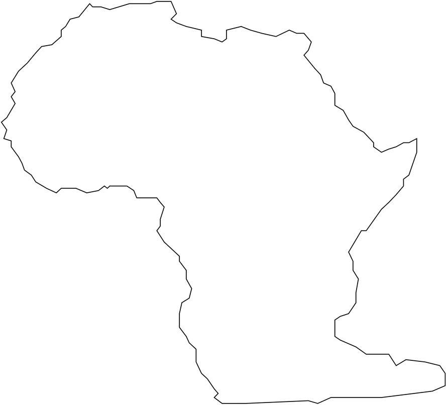
While al-Mas̒ūdī had an undeniable grasp of the shibboleths of his time, he lacked a complete understanding of Ptolemy’s coordinate system. For example, he wrongly characterized cities of the same “clime” [climate] as having the same latitude. This is further confounded by the fact that “qālīm” was the Arabic term for both kishvars and climes, as discussed previously; thus “geographic region” and “latitude” had the same meaning culturally, but not mathematically. As for the interior of Africa, at least one of his surviving maps depicts the “Unknown Region” of Africa quite differently than his predecessors. As figure two shows, al-Mas̒ūdī draws the “Unknown Region” as a sizeable island lying directly south of al-Sūdān. Based on what we know of al-Mas̒ūdī’s life, he traveled throughout the Horn of Africa, but likely not further south than Kenya. He would most certainly have heard of “trade islands” like Kilwa and Sofala to the south, and his maps show that he may have understood these islands to be landmass that also produced its own goods, and would have to be large enough to do so. Further confounding the matter, “peninsula” and “island” are both described with the same word, “jazīrah,” in Arabic, so even if it were accurately explained to al-Mas̒ūdī verbally, he may not have been able to transpose that into an accurate image. Coupled with the fact that overland trade was very rare in the Swahili coast due to its inefficiency, al-Mas̒ūdī seemingly did not understand that the goods and materials came from the same landmass as the Horn.
al-Mas̒ūdī also does not describe sub-Saharan Africa as extending towards India. al-Mas̒ūdī was much better traveled than most geographers and traders of his day and, importantly, he may have understood that deep ocean travel was something other cultures, like the Chinese and Malay, were quite proficient in. Because of this, he would not have assumed that Africa had to be close to the Far East in order for trade to be conducted between the two regions.
al-Mas̒ūdī’s representation of the “Unknown Region,” circa tenth century CE.

In addition to al-Mas̒ūdī, the most popular lineage in ‘Abbasid geography was the al-Balkhī School of the tenth century. Named for the earliest scholar in the line, Persian mathematician Abū Zayd al-Balkhī, the written geographies and maps generated by members of this tradition show the best examples of trends and continuities within Islamic Golden Age cartography. The work of students of the al-Balkhī school, particularly later members like Muhammad Abū al-Qāsim Ibn Hawqal and Muhammad ibn Ahmad Shams al-Dīn al-Muqaddasī, are considered to represent the height of geography in the ‘Abbasid period and directly influenced later Islamic cartographers like al-Idrīsī.Footnote 35 Maps in the al-Balkhī style were almost exclusively small, amimetic maps drawn in support of written geographies, intended to help the reader visualize the relationship between different features, cities, and people groups. They were directly embedded in the written text and were fairly sparse on details, generally isolating a geographic areas such as the Arabian peninsula or Mediterranean Sea and labeling only the critical features to visualize the content discussed in the accompanying written geography.Footnote 36
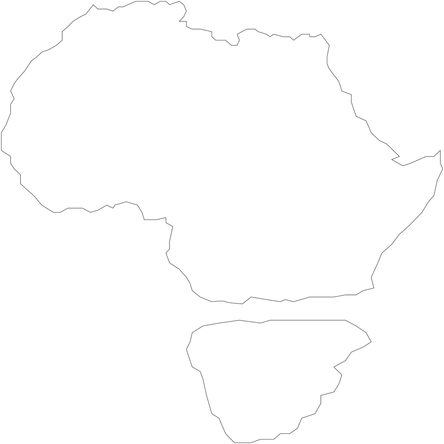
As established, information about different people groups within the African interior was very limited and nebulous. Trade of course existed between Malaysia, India, and East Africa long before the rise of Islam. Early eighth century traders and explorers from the Middle East, for example, upon finding Indian and Malaysian goods in Africa, might have found the concept of “blue-water” trade inconceivable. Arab seafaring was mostly a littoral endeavor throughout the ‘Abbasid Caliphate, with traders usually staying within a hundred miles or so of the coast.Footnote 37 Thus, it would have been natural to conceptualize that there was a land mass connecting Africa to Southeast Asia through which Afro-Malaysian trade was conducted, or otherwise that the sea journey was short and facile. Such a deduction helps to explain why early al-Balkhī maps made during the eighth and ninth centuries showed India connected to East Africa directly, and most other maps showing a very close point of approach between East Africa and India. Arabs may simply not have believed, or the thought may not have even crossed their minds, as these trading routes would have otherwise involved sailing so far away from the coastline.
The al-Balkhī school’s representation of the “Unknown Region,” circa tenth century.

The al-Balkhī school includes a continual trend towards more mimetically accurate mapping over time. While early maps might show the Mediterranean Sea as a simple oval connected to the Atlantic Ocean by an outlet on its eastern side, later maps from inheritors such as Muhammad Abū al-Qāsim Ibn Hawqal would include peninsulas representing Italy and Greece, a circle in the middle to represent Sicily, and more jagged lines throughout to characterize the uneven shape of the coastline. The later geographers of this school were not entirely faithful to this trend, sometimes leaving off details that were present in earlier maps such as islands, labels for different regions, or mountain rangesFootnote 38 This is likely to avoid cluttering the maps with too many words and fine details, in order to make it easier to quickly grasp the shape and relative locations of important features.
Conclusion: Sub-Saharan Africa and the “Unknown Region” in ‘Abbasid Scholarship
This article has demonstrated the manner in which, in many cases, geographers had to methodologically rely on reports from traders, travelers, pilgrims, and other explorers for their description of far-away lands. Sometimes the tales were almost too wild to believe. The descriptions of treacherous navigational hazards, dark religious practices, and islands with populations of wicked women even seemed preposterous to some ‘Abbasid scholars.Footnote 39 Still, it was often the only perspective the geographers had to inform their depictions of the world. So, deciding how to depict the Earth based on questionable details stands as a critical component of professional cartography throughout the ‘Abbasid Caliphate. We have worked to review both the prominent error in ‘Abbasid maps with a focus on “the Unknown Region” of contemporary Sub-Saharan Africa, alongside the prior influences that influenced mapmaking and led to misunderstandings and the manner in which ‘Abbasid geographers attempted to communicate what they did not know, and review possible reasons for this defect and its prominence.
However, for the purposes of better understanding the depictions of Africa, the prototypical shape of the Unknown Region described above bears striking resemblance to Ptolemy’s world maps, which show Africa extending into the Indian Ocean, along the Tropic of Capricorn, across the “bottom of the world,” and connecting to East Asia at the eastern extreme of the map. Most mimetic maps drawn during the ‘Abbasid period did not show it connecting to East Asia, with the Unknown Region forming a peninsula ending south of India. This is likely due to the fact that ‘Abbasid traders and explorers had a much better knowledge of the Indian Ocean, and recognized that Java and the “Malaysian Isles” were collocated with part of Ptolemy’s Unknown Region. However, several maps of Arabia from the al-Balkhī school show the Swahili coast of Africa connecting to the southern peninsula of the Indian subcontinent with the Red Sea, Arabian Sea, and Persian Gulf forming, in effect, a massive horseshoe-shaped lake.Footnote 40 These maps were regional, and did not necessarily correspond with al-Balkhī school depictions of the entire world.
We moreover reviewed that al-Mas̒ūdī provides an interesting counterexample, drawing what is perhaps the most mimetically accurate depiction of the overall shape of Africa. In at least one of his world maps, al-Mas̒ūdī draws al-Wāq-Wāq as a roughly trapezoid shaped island, with the narrow end pointing south. This roughly captures the shape of the southern part of the Swahili coast and the Cape of Good Hope, and when combined with the continent representing North Africa and the Sahara, is a reasonable approximation of the shape of the whole continent of Africa. As referenced earlier, al-Mas̒ūdī traveled to the horn of Africa in person, and was likely able to gather more detailed first-hand accounts of what the rest of the coastline looked like. al-Mas̒ūdī notes that it is difficult to rely on the accounts of merchants, as their tales were so fanciful that they were unbelievable, and likely embellished.Footnote 41
This article has shown that a prominent feature of almost all surviving maps from the ‘Abbasid period include an area in Sub-Saharan Africa termed al-Wāq-Wāq, or “the Unknown Region.” As depicted, we have shown that the Unknown Region varies slightly differently by the various geographers of the period, but that the Unknown Region frequently is characterized as a peninsula jutting sharply east of the continent and extending out into the Indian Ocean, nearly reaching south Asia. It is a dramatic departure from the otherwise fairly accurate representations of North Africa, the Middle East, and the Indian subcontinent. It is important to stress that the term Wāq-Wāq is not exclusive to this region of Africa; the term appears in many places on world maps drawn by scholars, such as al-Idrīsī, marking unnamed regions of land and parts of the ocean that had not yet been explored. In unknown parts of the ocean, islands were sometimes arbitrarily drawn and labeled Wāq-Wāq or simply Wāq. So, it is plausible that the shapes of these regions were arbitrary, intended only to reflect that something could be there.
The lack of consistency belies a lack of interest by the period’s scholars in the topic. We map out the reasons why ‘Abbasid geographers had neither a large body of knowledge nor interest in Sub-Saharan Africa nor the Swahili coast south of the Horn. First, there was little economic incentive to explore further, as by the middle of the tenth century the Caliphate’s trade network was well established with contacts in the hinterlands. Second, very few geographers had much interest in visiting this part of the world, with al-Mas̒ūdī as one notable exception. Consequently, we have emphasized the way that geographers had to resort to armchair quarterback guesswork for the areas that were not well traveled by ‘Abbasid geographers or traders. We have also emphasized the way that pre-Islamic cartography contributed to errors, specifically that the reverence that ‘Abbasid geographers has for Ptolemy naturally influenced the map making of Islamic cartographers. To conclude, we contend that it was understood among ‘Abbasid geographers from the ninth and tenth century that al-Wāq-Wāq did not actually reflect the shape of that part of the world, but rather represented a deliberate and intended way for cartographers to represent a lack knowledge of Africa south of the Maghreb alongside judgments of the type of people who lived in the region.
Ryan W. Shea graduated from Vanderbilt University in 2018 with a Bachelor’s of Engineering in Electrical Engineering. His interest in the history of Islam began with his study of Arabic at the Indiana University Summer Language Workshop and his travels in Israel and Morocco to study history and religion. Shea currently serves in the US Navy as a Student Naval Flight Officer stationed in Pensacola, Florida. E-mail: ryan.shea@vanderbilt.edu
Dianna Bell studies the history and ethnography of Islam and indigenous religion in West Africa, especially Mali. Her work has been featured in several flagship journals and covers a wide variety of topics, including Islamic education, religion and climate change, Islam and dream interpretation, and how religion factors into the treatment of animals in Mali. She served as a co-author for chapters on African religions for the Oxford Handbook of the Anthropology of Religion and The Blackwell Companion to Religious Diversity. Her book Between Prayers: The Life and Merit of a West African Muslim is currently under contract with Duke University Press. E-mail: dianna.bell@uct.ac.za