

INTRODUCTION
A group of excavations of London’s medieval waterfront during 1974–84 has recently been published (fig 1):Footnote 1 an account of four excavations carried out during the first decade of reasonable archaeological provision in the City of London. Study of their artefactual material has laid the foundations of many kinds of archaeological research in London and imitation elsewhere in the decades that followed, which continues forty years later. They are also part of a series of excavations that has taken place since the 1970s on both sides of the River Thames and which still continue when sites are redeveloped today.
The port of London in 1200: showing the locations of most of the waterfront excavations since the 1970s. St Paul’s Cathedral is shown with its outline around 1300, when it is first known with certainty. Drawing: © John Schofield. Key: 1 Blackfriars Station Thameslink; 2 Millennium Bridge N bank and Trig Lane; 3 Bull Wharf and Thames Exchange; 4 Steelyard; 5 Watermark Place, Riverbank House and Swan Lane (site A); 6 Seal House (site B); 7 New Fresh Wharf (site C); 8 Billingsgate (site D); 9 Custom House; 10 Millennium Bridge S bank; 11 Winchester Palace; 12 Medieval London Bridge S end; 13 Dunley Place and Rosary (Archaeological reports on these sites are: (1) Stafford and Teague 2016; (2) Milne and Milne 1982; Ayre and Wroe-Brown 2002; (3) Ayre and Wroe-Brown 2015; (4) not yet published; (5) Fowler and Mackinder 2014; Mackinder 2015; (6–8) Schofield et al 2018; (9) Tatton-Brown 1975; (10) Ayre and Wroe-Brown 2002; (11) Seeley et al 2006; (12) Watson et al 2001; (13) Blatherwick and Bluer 2009.)

The area of this study is the waterfront south of Thames Street between the sites of the eleventh-century All Hallows the Great church in the west (today just to the east of Cannon Street railway station viaduct) and the probably tenth-century Billingsgate landing-place in the east (its site covered by the former fishmarket building of 1875), a length of about 475m (approximately 1,550ft). Just over half way along this length of waterfront, the north end of medieval London Bridge met the bank of the river and the street. The focus of research is two blocks of properties: eight tenements upstream of the bridge, labelled for this study Tenements 1–8; and a second block downstream of the bridge, labelled Tenements 9–16. The first block was excavated on two sites – Swan Lane (site A) and Seal House (site B) – in 1981–2 and 1974; the second block, downstream of the bridge, was excavated on the New Fresh Wharf (site C) and Billingsgate Lorry Park (site D) in 1974–8 and 1982, with a watching brief during massive earth-moving on the latter site in 1983–4 (fig 2).Footnote 2
The sites of the four excavations south of Thames Street, City of London, in their relation to the modern and medieval London Bridges. The Museum of London sitecodes identify the sites: SWA81 = Swan Lane; SH74 = Seal House; NFW74 = New Fresh Wharf; and BIG82 = Billingsgate Lorry Park. Drawing: © MOLA.

MAIN CHARACTERISTICS OF THE WATERFRONT AREA 1100–1666
Between 1100 and 1666 the waterfront of the City of London, between Thames Street and the River Thames, grew by extension into the river until fossilised by the erection of stone river walls. Earth and rubbish were used to make the reclamation units, which are often dated by the dendrochronology of timbers used in the waterfront structures. Many of these have been excavated on sites south of Thames Street since 1973 (see fig 1); four sites around the bridgehead are reported here. By the end of the main period of reclamation, around 1450, the new land south of the street could be up to 100m wide, formed by innumerable expansions on private and public properties (fig 3), which had the effect of making indented inlets or docks for ships at Queenhithe and Billingsgate. All of Thames Street and its wharves were destroyed in the Great Fire of London in 1666.
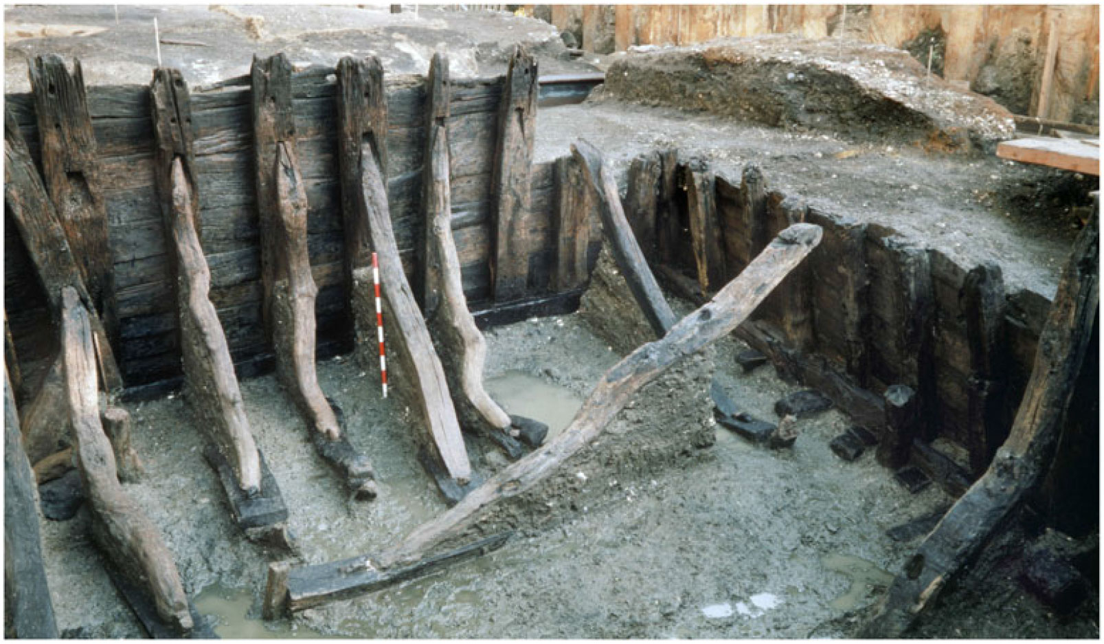
The early thirteenth-century waterfront excavated on the Billingsgate site, 1982, looking north from the riverside. The section of revetment on the left (D:Waterfront 14), dated by dendrochronology to about 1235, was later conserved and displayed in the Medieval Gallery of the Museum of London. Photograph: © MOLA.

The documentary history of these tenements is among the richest that can be provided for any secular properties in the City. The history of owners and tenants can be reconstructed, and information compared with the archaeological findings to study public and private space, the network of waterfront alleys, the components of tenements and the process of subdivision, specialised buildings and equipment, warehouses and cranes. There are also detectable differences in land use above and below the bridge, particularly from the sixteenth century onwards; this was probably in part a consequence of the fact that after 1475–6 the central drawbridge on the bridge could not be raised to allow ships through. In 1559, the subsequent establishment by the Elizabethan government of the Legal Quays (a group of existing quays located largely below the bridge and designated for the receipt of foreign imports that could be taxed) was probably instrumental in moving the landing places for foreign goods downstream of the bridge. This government act changed the London topography.
Over the five and a half centuries studied here, changes in the topography, building design and material culture of the studied properties south of Thames Street can be observed (table 1). These developments will be outlined below.
Observed changes over time on the study sites in Thames Street, 1100–1666

WHAT CAN BE LEARNT FROM WHAT WAS THROWN AWAY IN THE PAST?
The waterfront was essentially the dumping ground of household and trade waste from the city, which had a population of at least 80,000 in the early fourteenth century. This officially approved method of rubbish disposal was practised from the opening of the eleventh century until the fifteenth. A first question concerns how the reclamation dumps came to contain the pottery and artefacts, and what can be said about the character and date of the material. Where did the pottery and artefacts come from? What, if any, significance can we assign to their findspots (behind waterfront revetments or on foreshores), or are they all hopelessly mixed up because they were mixed up before they were brought here? The pottery and the non-ceramic artefacts seem to give different answers. In some cases, the amount of pottery of specific wares occasionally suggests they may have been used locally (for example, by groups of foreign merchants). The artefacts, on the other hand, include a small number of concentrations of trade waste, but seem to reflect a very wide range of functions, tastes and dates (many would have been old when thrown away). It is best to regard the rich material of both types as the everyday debris of the entire City of London, possibly composed of locally accumulated middens or public laystalls. When the main period of reclamation slowed down after c 1450, as stone riverwalls became more widespread, the dumping of large amounts of rubbish seems to have been switched to form similar land reclamation in the marsh north of the city wall at Moorfields.Footnote 3 Throughout this period up to 1450, and afterwards, the waterfront sites also provide rich and well-dated artefactual evidence from buildings as well as reclamation units (fig 4). This is primarily because Thames Street was raised, along its mile-long length, by between 6ft and 8ft (1.8m and 2.4m) after the Fire of 1666 by using the vast amount of Fire rubble then available. This action left the pre-Fire buildings safely positioned below the later Victorian basements, which have elsewhere removed a very large proportion of the City’s medieval and Tudor buildings (a point returned to below).
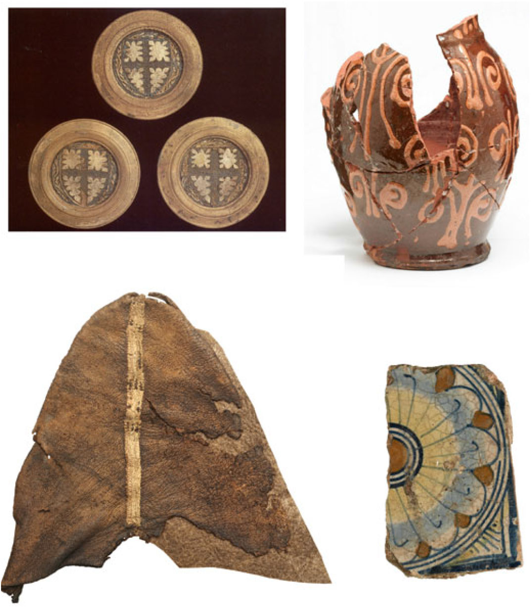
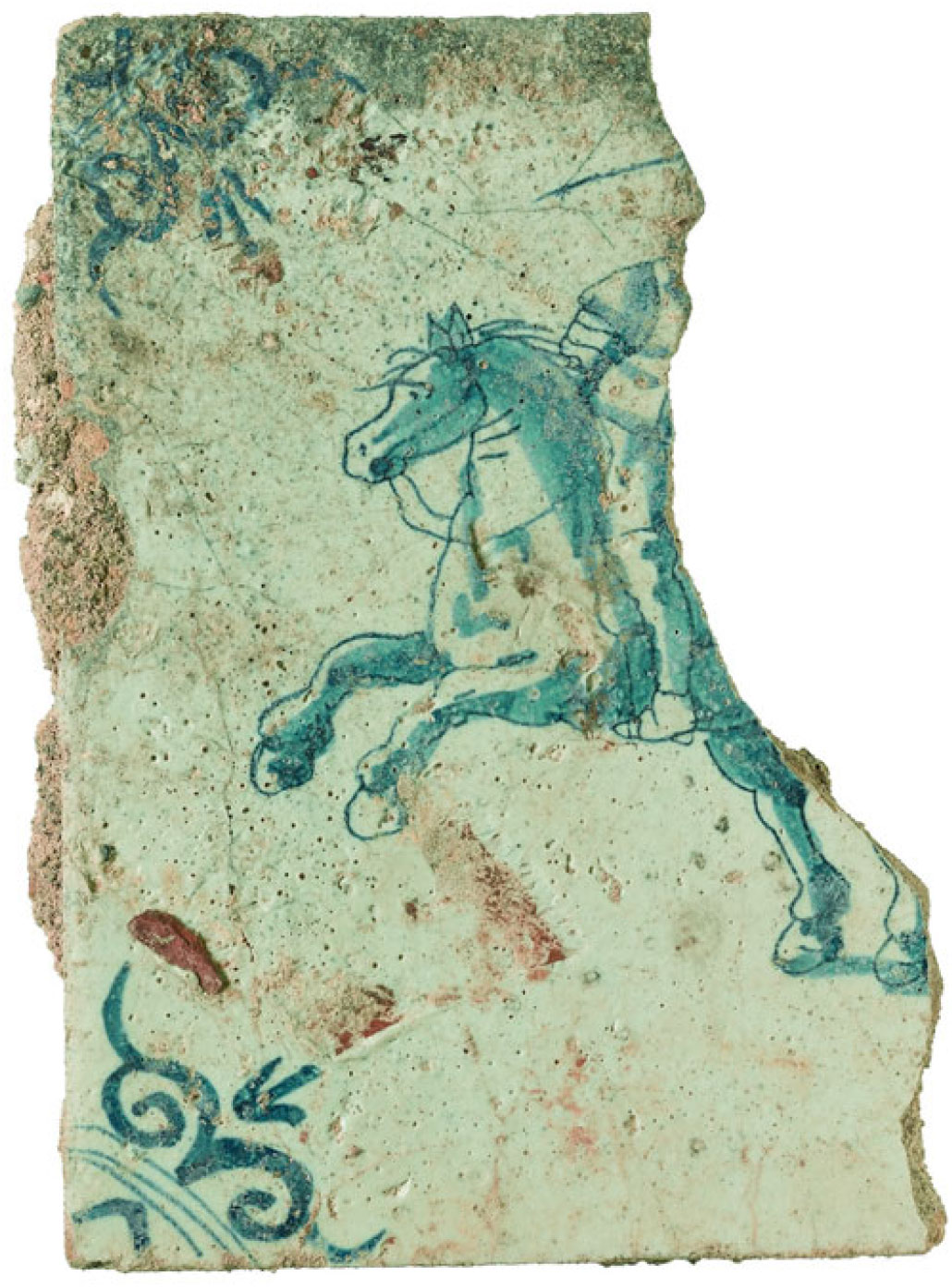
Artefacts from reclamation deposits and buildings: (clockwise from top left) a group of armorial mounts with identical shields, found probably surrounded by coarse cloth on Swan Lane, probably mid fifteenth-century, from horse harness or for fitting to swords; a seventeenth-century Metropolitan ware jug from Billingsgate; fragment of a sixteenth-century tin-glazed floor tile made in Antwerp, from Billingsgate; and a shoe from a twelfth-century reclamation deposit at Seal House, with an embroidered vamp stripe. Photographs: © MOLA.

Medieval London was characterised by a large variety of every kind of material culture. Study of the native and foreign pottery over the last five decades has produced a dating structure of at least 123 different native and foreign pottery wares in use in the city in the medieval and post-medieval periods.Footnote 4 This is now customarily used by major post-excavation projects in the London area; and in general the sequences of pottery from riverfront sites in London and elsewhere have had a major impact on the ability of archaeologists to date and interpret medieval sites.Footnote 5 The waterfront sites since 1972 have also provided the majority of artefacts, mostly accurately dated, for the catalogues produced between 1987 and 1998 (the Medieval Finds from Excavations in London series).Footnote 6 While many objects speak of fashion and status, those comprising dress (clothes, accessories, shoes) were perhaps the most expressive and powerful way of making statements. Two aspects of the non-ceramic artefacts are first highlighted here: what some of them say about religious beliefs; and what they all say together about a consumer society.
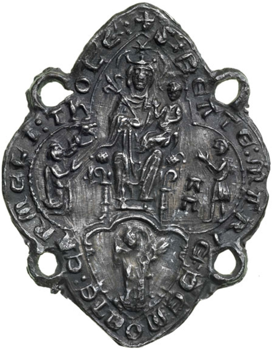
Medieval Londoners or people passing through London threw away a lot of pilgrim souvenirs and secular badges that indicate group membership; and much about beliefs, loyalties and perhaps literacy can be ascertained from these. In 1998 Brian Spencer produced his Pilgrim souvenirs and secular badges volume in the Museum of London’s Medieval Finds from Excavations in London series; this catalogued around 800 recently discovered badges from the City of London as a whole (many others have been found since, some recorded in the Portable Antiquities Scheme). The majority of those catalogued by Spencer were from waterfront excavations since 1972, and a total of 378 were from the four study sites: sixty-three from Swan Lane; seven from Billingsgate; and 189 – over one-third – from the watching brief on earth-moving after excavation at Billingsgate, which took place in 1983–4. The remarkable numbers at Swan Lane and from the watching brief at Billingsgate were largely the product of Geoff Egan’s work with skilled users of metal detectors, both on and off the sites. These 378 badges, dating from the twelfth to the fifteenth century, feature a galaxy of saints from both British and Continental sites; for example, the shrine of the Virgin at the Carmelite friary in Toulouse (fig 5). There were over sixty badges from Canterbury, some of high artistic quality. A number of souvenirs have Latin or French inscriptions, sometimes abbreviated, alluding to their site (‘Behold Edward!’), though others have mistakes that indicate a struggle with literacy. The finding of many of these souvenirs and badges in the silts of the medieval Thames invites future research into the practice of throwing religious objects into watery places.Footnote 7 Secular badges tended to be from later strata, of the fifteenth century. Notable among the other secular objects from the sites were lovers’ trinkets and a mirror case with scenes from the story of Tristan and Isolde.
Pilgrim souvenir from the shrine of the Virgin at the Carmelite friary in Toulouse, which was found at Swan Lane (Accession [2150]) (h: 53mm). A female pilgrim on the left is being miraculously delivered from insanity, a winged devil issuing from her mouth (an allusion to a miracle of 1265). On the right, a male pilgrim stands up, recovered from paralyis. Below the Virgin, a Carmelite friar kneels in prayer (Spencer Reference Spencer1998, 242–3). Photograph: © MOLA.

The range of these everyday things, the evidence of mass production of, for example, buckles, belt fittings and dress ornaments, and the sheer number of near-identical items witnesses ‘the thriving market for the consumption of goods that documentary sources attest’, as noted by Egan.Footnote 8 This mass market for consumer products was on a large scale by 1300, and it perhaps started in the eleventh century in the peculiar circumstances of London.Footnote 9 Fashions in decoration can be detected on the objects. Whether an increasing standardisation of style in objects of everyday use, such as dress accessories, was imposed by suppliers or demanded by consumers is a separate question, not yet tackled. It would also be interesting to know whether London after 1350 became a distinctly consumer city, as has been suggested for Paris, because of its character as a capital city and the proximity of the royal court.Footnote 10
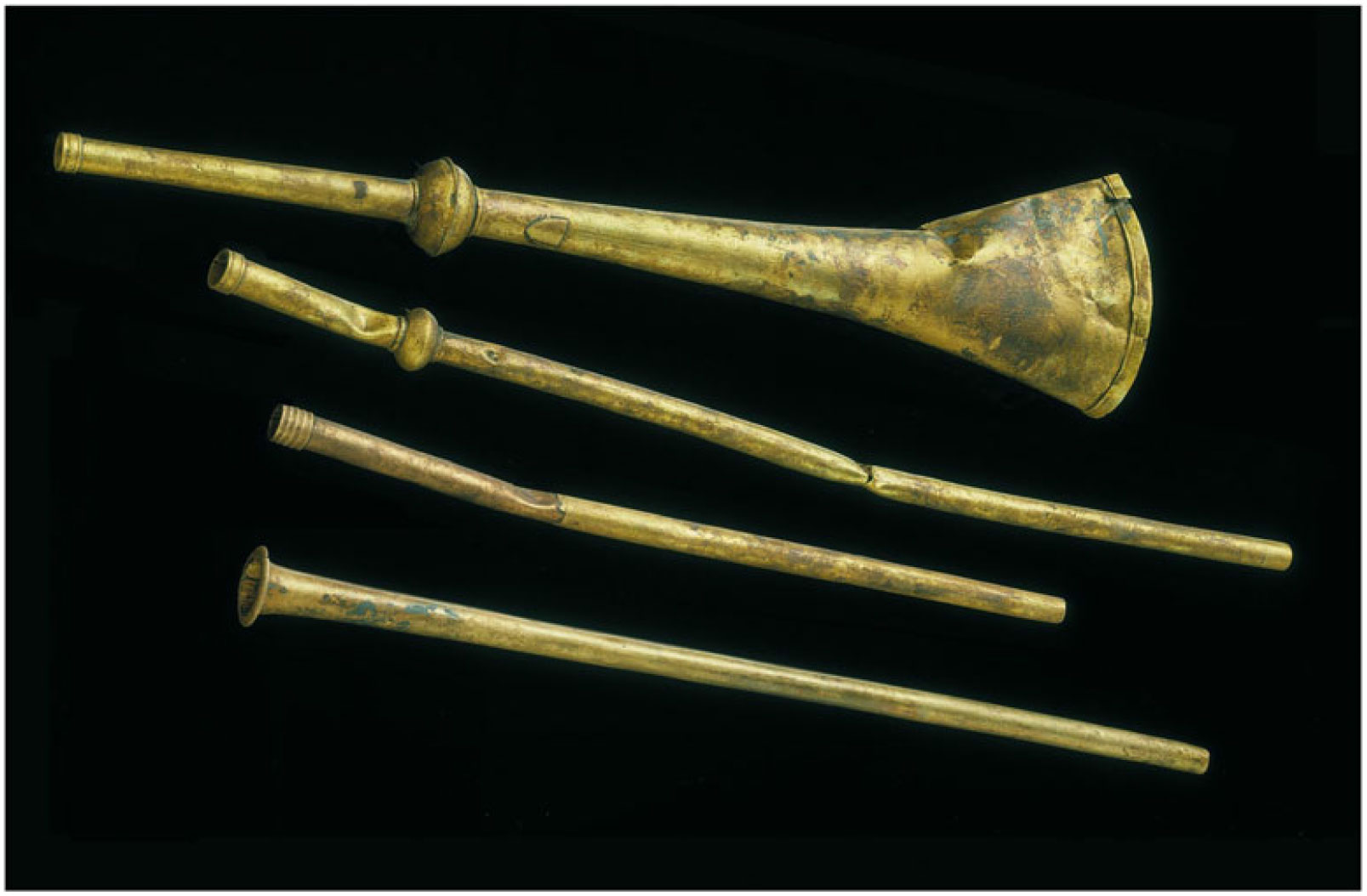
Two objects of special interest from waterfront sites are a pair of fifteenth-century spectacle frames from Trig Lane, reported in this journal in 1982,Footnote 11 and the Billingsgate trumpet (so called from the site where it was found), one of the earliest surviving examples of a medieval musical instrument from Europe, and the only known example of a medieval European straight trumpet (fig 6).Footnote 12 This was found in river silt dated by pottery to 1260–1350.
The Billingsgate trumpet was found during earth-moving on the Billingsgate site in 1984. It may have been lost from a ship in the period 1260–1350. Photograph: © MOLA.

The 2,600 non-ceramic artefacts from the four project sites that feature in the Medieval Finds from Excavations in London volumes are now listed according to the strata in which they were found.Footnote 13 This means that the artefacts and pottery from each unit of reclamation and foreshore can be seen together, not in separate catalogues.
LONDON AND THE EUROPEAN TRADING NETWORK
The study of foreign pottery on these sites has improved our understanding of London’s place in European trade, especially in the twelfth century, with many places around the North Sea and deep into the Rhineland; pottery originating from the London area in the twelfth and thirteenth centuries is found in British towns up to the north of Scotland, and in present-day Norway, Sweden and Denmark (fig 7). There are imports from Germany, France and the Low Countries.Footnote 14 By 1200 there were merchants of several other important European cities resident or staying for periods in London: over thirty from Dublin, for example, and others from Flanders and possibly Genoa (where there was a thriving English community, including many Londoners).Footnote 15 Danes and Norwegians had privileges in twelfth-century London that may have been established before the Conquest, in the reign of Cnut (1016–35); merchants from Rouen had brought or sent wine to Dowgate then or shortly after.
Finds in Europe of three types of pottery made in the London area in the twelfth and thirteenth centuries: LOND = London-type ware; LCOAR = coarse London-type ware; and SSW = shelly-sandy ware (Blackmore and Pearce Reference Blackmore and Pearce2010, fig 3). Drawing: © MOLA.

Examples of Continental pottery, from France, Spain, Italy, the Low Countries and Germany, continue to be found in strata of the thirteenth to seventeenth centuries, scattered all over the City; some seventeenth-century examples are shown (see figs 10 and 11). A recent archaeological overview of trade in medieval Britain suggests that the dominance of economic historians in this subject until recently is only now being addressed,Footnote 16 so this offers scope for future research.
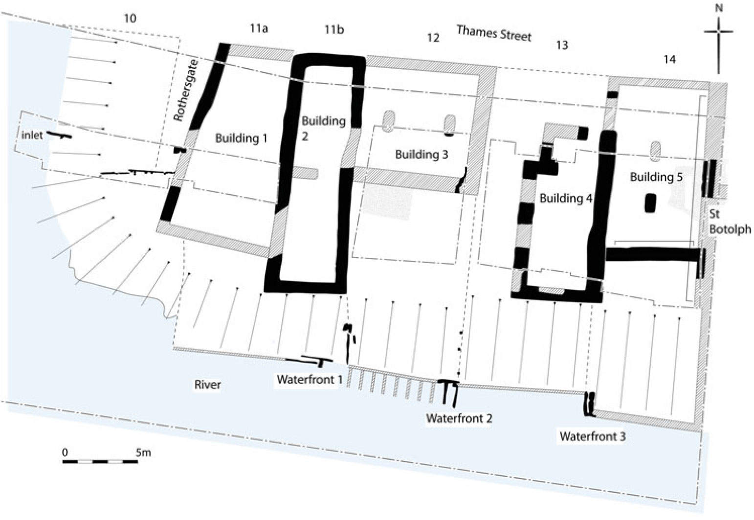
Twelfth- and early thirteenth-century buildings on the New Fresh Wharf site, excavated 1974–8. They formed a row of stone buildings along the street next to St Botolph’s church and Botolph Wharf (next to the church, right). In these site plans, the dark shading indicates the parts of walls recorded, the hatched shading is conjectural parts. Drawing: © MOLA.

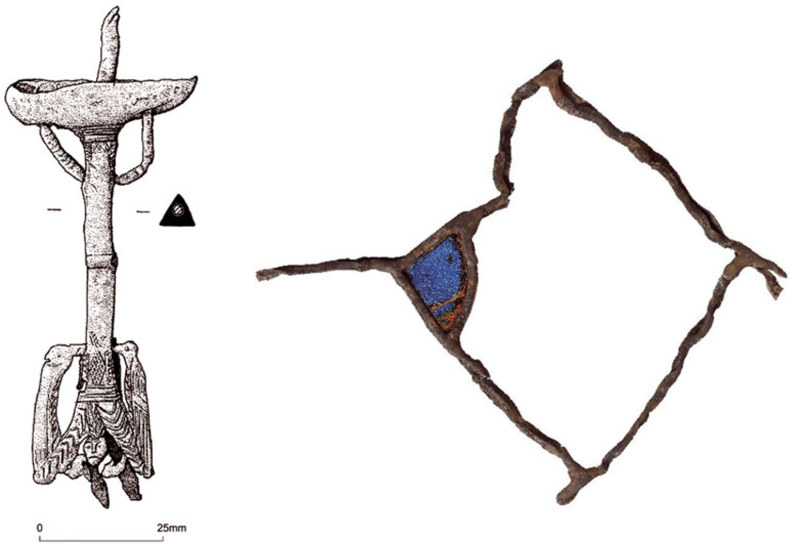
Household fittings and equipment from the Swan Lane site: (left) an iron and lead candlestick with birds and possibly human figures, perhaps twelfth-century, from a reclamation dump of 1180–1270; (right) a fragment of window cames with coloured glass, from a reclamation deposit of 1270–1330. Photograph: © MOLA.

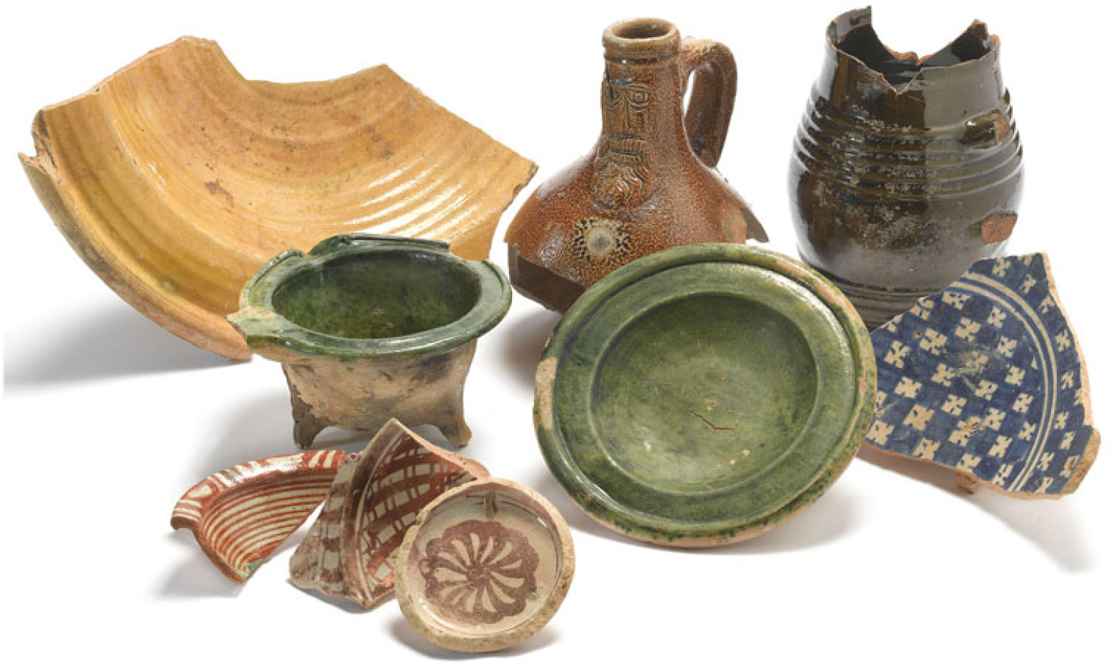
Native and foreign seventeenth-century pottery from a drain on the New Fresh Wharf site, perhaps from the household of William Widmore, plasterer. (Back row, from left to right) Surrey–Hampshire border whiteware bowl, Frechen stoneware Bartmann jug, Surrey–Hampshire border ware mug. (Middle row) Surrey–Hampshire border whiteware skillet and dish. (Front row) Werra slipware dish and two mature Valencian lustreware porringers. Photograph: © MOLA.

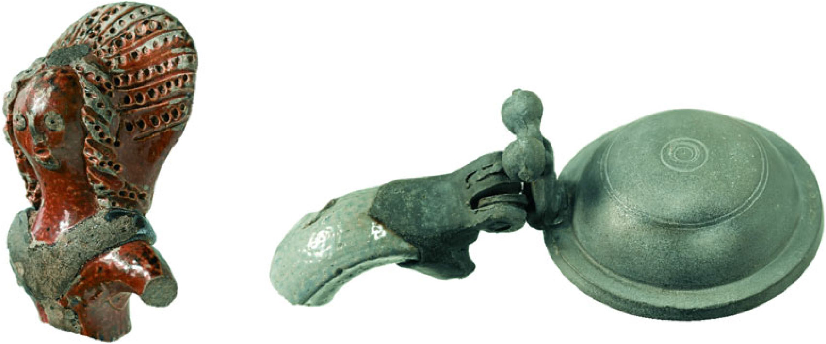
From a drain on the Billingsgate site full of artefacts, part of the household effects probably destroyed in the Great Fire: a Raeren stoneware statuette of a woman with an elaborate head dress and a pewter lid from a Westerwald stoneware mug. Photograph: © MOLA.

Here we might pause to consider international connections of the artefacts and the buildings on London waterfront sites. For the pottery and the few artefacts that can be identified as foreign products (for example, glass vessels), caution is necessary. Pottery, such as the distinctive jugs from Saintonge (south-west France) and many other European places, indicates cultural contact. The Hanse merchants, from their steelyard immediately west of the study sites, were an important economic presence in London until 1598. It is, however, a mistake to correlate continental imports with wealth and status, as the waterfront location brought foreign goods into more widespread circulation. Medieval Islamic pottery and glass are now found in small quantities on several sites in the City. Finds illustrative of the rise of London to be the hub of a new empire after 1600 have not yet been recognised, and may be a feature of the decades after 1666. Cultural links in house design and decoration are a separate matter. The buildings on waterfront sites are fitting into the general patterns observed by antiquarians and archaeologists in the last 200 years.Footnote 17 In the twelfth century, stone buildings in London shared the Romanesque style found from Southampton to Prague. In the thirteenth and fourteenth centuries, the sharing may have been partly with buildings in much of France, though styles of timber framing and decoration were different.Footnote 18
URBAN DEVELOPMENT OF THE WATERFRONT AREA
The waterfront excavations contribute to a history of buildings in London and Britain from 1100 to 1666. The timbers dated by dendrochronology to the twelfth and thirteenth centuries chart developments in building construction that precede the earliest datable examples in medieval houses standing in other towns, both in Britain and on the Continent.Footnote 19 There have been surprises, such as the fragments of a tenth-century timber arcade found near Queenhithe at Vintners’ Place.Footnote 20 The number of recorded thirteenth-century examples of joints is growing, and in time the appearance and early history of jettied buildings will be elucidated by dendro-dated examples from the waterfront (London has a very early reference to the nuisance of jetties along several lanes in 1246, but so far no clear examples of joints that must be from jetties have been recorded on site).Footnote 21
There is evidence that the waterfront area around London Bridge was assuming a distinctive character, but perhaps not yet much different from inland sites (that is, north of Thames Street). We do not have much information about the density of settlement within the walls in the twelfth-century city. Many parish churches were in place by this time, indicating local points of settlement, but, as in contemporary Rome (at least in the first half of the century), the overall pattern of settlement may have been patchy, clumps of buildings separated by open spaces.Footnote 22 Single stone buildings in their properties were widespread in the City, but one local concentration of several continuous stone buildings along a street were those between St Botolph Billingsgate (and Botolph Wharf) and London Bridge, as excavated on the New Fresh Wharf site (fig 8). There were probably a number of such stone-built stretches in the twelfth and especially the thirteenth century on the waterfront. They would signify points of access to the river and trade, increasingly an international matter.
The development of Thames Street in its central section on either side of the north end of the bridge in the twelfth century has similarities with that of the main inland market street of Poultry, the eastward extension of Cheapside. The main frontages to Poultry were developed from the late tenth or eleventh century, first with small timber buildings, some in rows and at right angles to the street, and later by a pronounced density of stone buildings from the late twelfth century.Footnote 23 As might be expected, stone buildings are one index of wealth at this early period.
There were two thirteenth-century developments in the construction of stone buildings in London, at least in their lower parts. The first was the use of piles and arched foundations below large stone buildings or long boundary walls, as exemplified by site C: Buildings 6 and 7 (not shown in plan here, but at the west (left-hand) end of the excavation shown in fig 8) at New Fresh Wharf. A deep trench was dug along the east side of Tenement 9, down to the underlying timbers of the third-century Roman waterfront around which the lowest parts of new foundations were then packed. Two wide parallel walls of chalk and ragstone, with crude arching, were then built, one along the boundary with Tenement 10, the other a short distance to the west to form the inside of an alley that would run within Tenement 9, along the tenement boundary.
A second feature of the thirteenth century – in London as in other English and Continental towns as far north as VisbyFootnote 24 (Sweden), on the island of Gotland in the middle of the Baltic – are stone undercrofts with vaulting, either groined (the vaulting unemphasised) or exceptionally with stone arches, sometimes further embellished with carved corbels, occasionally painted. These were significantly different from those beneath stone buildings of the twelfth century, and probably more widespread. The new intentionally attractive undercrofts were usually tied to the street, and were entered from it; they might have secondary internal stairs to the house above. They were intended for the storage and selling of valuable commodities, such as wine.Footnote 25 A large group is sited at New Winchelsea, where the needs of the wine trade may have been especially influential. This led to the use of vaulted undercrofts as taverns in several towns in the fourteenth century (for example, at Winchester and Bristol,Footnote 26 and probably London).
By the 1330s there are standing medieval buildings to look at in English towns, which serve as parallels for the lost houses of medieval London: one such surviving building at 39 Strand Street, Sandwich, is a general model for a medium-sized house of this period.Footnote 27 Buildings and properties on major streets in the larger city were also subject to other economic forces. Subdivision of properties, at least in the commercial areas of the City, was common in the thirteenth century. By 1350, on the waterfront sites, there is documentary evidence for the division of many properties into smaller (horizontal) parts. From this time onwards there was also much acquisition of waterfront properties by institutions such as the City, St Paul’s, parishes (including fraternities at some churches) and livery companies, either by purchase or bequest. Whether this affected the forms and arrangement of buildings could be considered; properties in institutional ownership may have been under pressure to become more fragmented to increase income from rents, but more examples are needed and this may be an anachronistic way of looking at medieval property management in the City.
The excavated examples of fittings in London are a contribution to the earlier end of any national catalogue derived from standing buildings.Footnote 28 So far, principally in Egan’s The medieval household in the Medieval Finds series (1998), there are hinges, lead window cames, iron hooks and handles, possible drape rings and mounts and handles from chests (fig 9). The earliest of these date from the second half of the twelfth century. The construction and texture of medieval stone and brick buildings, both secular and religious, is illuminated by the study of floor and wall tiles, roof tiles, bricks and varieties of stone. At St Botolph, decorated floor tiles came from London’s three main sources, now called ‘Westminster’, Penn and ‘Eltham Palace/Lesnes Abbey’ groups, in the thirteenth and fourteenth centuries. Later, tin-glazed floor tiles came from Antwerp and several London kilns, two on the south bank of the river itself. Bricks from the Low Countries, known in London from 1278, were used in the walls of an undercroft on the Billingsgate site; and from the opening of the fifteenth century, bricks made in the London area are employed in all sorts of building,Footnote 29 though this development requires further research and examples.
As a group, the excavated buildings provide an important collection of dated examples from the waterfront area to match others now being produced by other large archaeological projects in the City (for example, the study of the east end of Cheapside and Poultry published in 2011).Footnote 30 We can now compare areas of the City through their medieval and Tudor building stock. This is an analysis of London’s former townscape at a new level, which did not seem possible a few decades ago. The excavated evidence on waterfront sites for developments in plan form of domestic buildings, though sometimes fragmentary, can be compared with the richer evidence of surveyed plans of London properties in the opening years of the seventeenth century, now also published.Footnote 31 The main contribution of the waterfront sites to the archaeology of London buildings is to provide rich evidence from the fourteenth century to the Great Fire, which is generally lacking from sites in the inland City, away from the waterfront. This feature of the sites south of Thames Street is largely due to the raising of the ground surface after 1666, which protected levels in previous buildings to a higher degree than elsewhere.
The analysis of pottery in order to illustrate activities or the uses of buildings at any one moment or over time is developing in specific exercises studying seventeenth-century pottery and artefacts in a drain at New Fresh Wharf (fig 10) and scattered through several buildings and another drain at Billingsgate (fig 11).Footnote 32 In both cases the material can be associated with named people, though tenuously.Footnote 33
HOW BUILDINGS ON THE WATERFRONT WERE USED
From this rich array of material, we elucidate the functions of rooms and spaces by examining the buildings, the artefacts within them and the documentary evidence (fig 12). Warehouse or storage functions can be suggested for ground-floor or basement rooms, with artefactual evidence of domestic accommodation in the storeys above some of them. Thus, groups of buildings standing at the same time can be analysed for their functions, to parallel similar exercises using the surveyed plans of London houses in the early seventeenth century.Footnote 34
Billingsgate: isometric drawing of the excavated buildings in period 15.9 (from c 1635 to 1666), looking north east. Analysis of the pottery and artefacts suggests that building B7 was domestic above a warehouse, B8 utilitarian (probably a shop fronting onto Thames Street to the north), the medieval undercroft B5 used for storage and B6 a warehouse. Drawing: © MOLA.

The external and internal appearance of the seventeenth-century houses, as that of their medieval predecessors, is largely unknown, but they had stylish elements. Some buildings on the Billingsgate site destroyed in the Great Fire of 1666 had Dutch tiles in their rooms (fig 13); perhaps a fashionable European tone in richer houses among the utilitarian buildings of the waterfront. It can be assumed that houses in brick were becoming more widespread from the 1630s, though were still in a minority.
Seventeenth-century tin-glazed wall tile from Billingsgate, from a building probably destroyed in the Great Fire of 1666. These tiles may have been made in The Netherlands or in London; they are evidence of strong cultural links with Holland. Photograph: © MOLA.

These tenements were a mixture of domestic and work buildings from the start. Industries or crafts that made or processed things are evident in the twelfth-century dyeworks on the Swan Lane site (fig 14), a possible fish-drying house at Seal House and other industrial buildings to be explored in the future from debris within them. What is probably another dyeworks on the waterfront south of the Swan Lane excavation is shown by Hollar in 1647 and is identified with known construction works on the site in this part of 1638 or shortly after (fig 15).
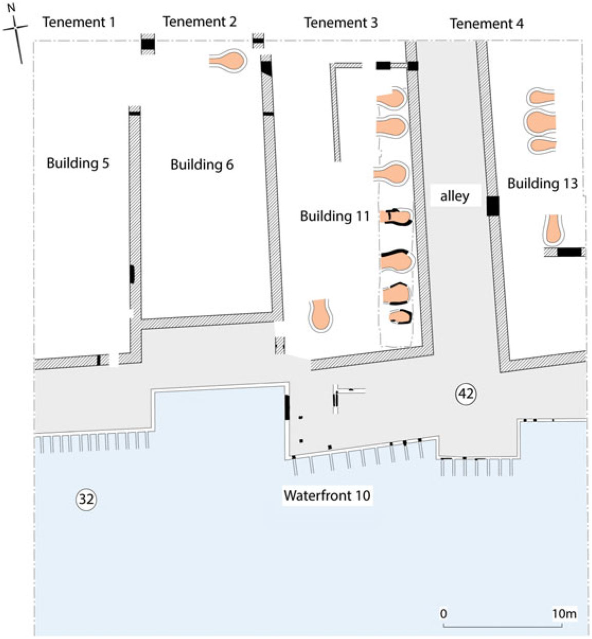
Swan Lane, period A2 (mid to late twelfth century). The numbers in circles indicate the general positions of the reclamation and foreshore Groups A32 and A42.
Drawing: © MOLA.

Detail from the panorama of 1647 by Wenceslaus Hollar, showing cloths hanging from poles on a building on the waterfront side of the Swan Lane site, probably part of a documented rebuilding of the property in or after 1638 as a house and dyeing establishment. The archaeological excavation took place in the area of buildings behind the waterfront. Image: © The Trustees of the British Museum.

The dyeing industry, requiring a large amount of river water, was a feature of the area upstream of the north end of London Bridge from the twelfth century, and continued to be so until the Great Fire of 1666. By the fourteenth century its facilities were shared with brewing establishments, which became complexes of equal size by 1600. Around 1500, dyers established their livery company hall on the edge of the Swan Lane site, and this is known through an inventory of fittings in 1602. In the fourteenth to seventeenth centuries there was probably an industrial tone to parts of Thames Street, which would influence the land use and form of the private and corporate buildings. From the present state of knowledge, it would however be unwise to call the street an industrial suburb as it also contained large houses, some palatial, though it distinctly lay below the ridge formed by Cannon Street and Eastcheap, both vigorous commercial streets, and all of its south side was open to the river.
ST BOTOLPH, BILLINGSGATE
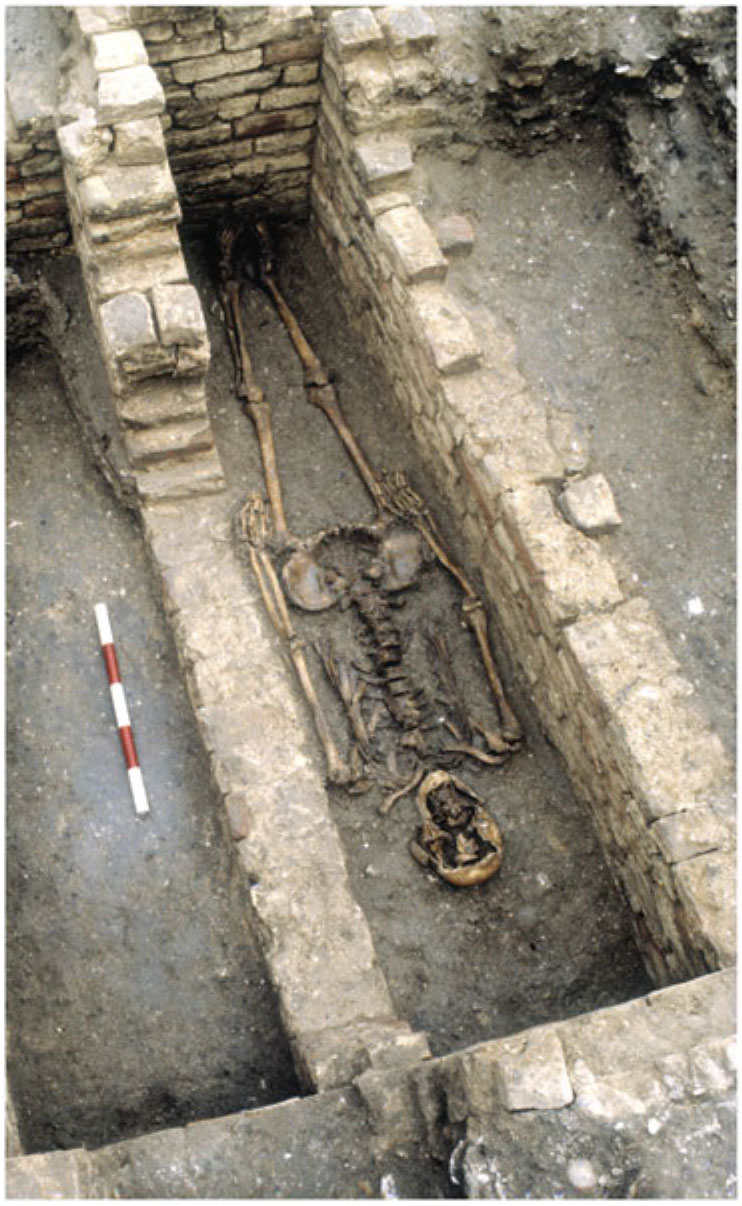
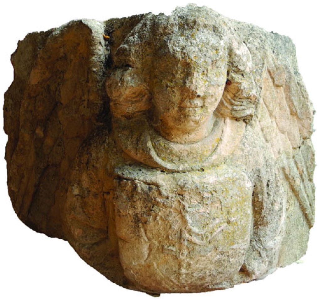
The excavation at Billingsgate included the south half of a parish church, destroyed in the Great Fire and not rebuilt. St Botolph Billingsgate, first mentioned around 1140, expanded to the south in the middle of the fifteenth century through a grant to the parish by John Reynewell (mayor 1426–7) or his trustees by 1456 at the latest; a grave in the new extension contained two skeletons, and one may be Reynewell himself (fig 16). The church extension included an existing stone building a few metres to the south, which was then incorporated into the body of the church. During the earth-moving during construction at Billingsgate in 1983–4, an impressive stone corbel carved with an angel holding a shield bearing a merchant’s mark (probably from the church, and possibly from the roof of Reynewell’s extension) was recovered from a landfill site in the lower Thames estuary, to where the spoil had been taken (fig 17).
In the extension southwards of St Botolph’s in the fifteenth century, this man and a woman were buried in brick tombs in the middle of the new space, probably facing a new altar. This view shows the male skeleton; the woman was beneath (scale 0.5m). The man may be the sponsor of the extension, John Reynewell (d. 1445). Reynewell was a prominent City merchant who rebuilt the drawbridge gate of London Bridge during his mayoralty. Photograph: © MOLA.

The angel corbel found on a landfill site in the lower Thames, to which earth from the Billingsgate site was transported in 1983–4; probably from St Botolph’s church. Height 323mm. Photograph: © Guy de la Bédoyère.

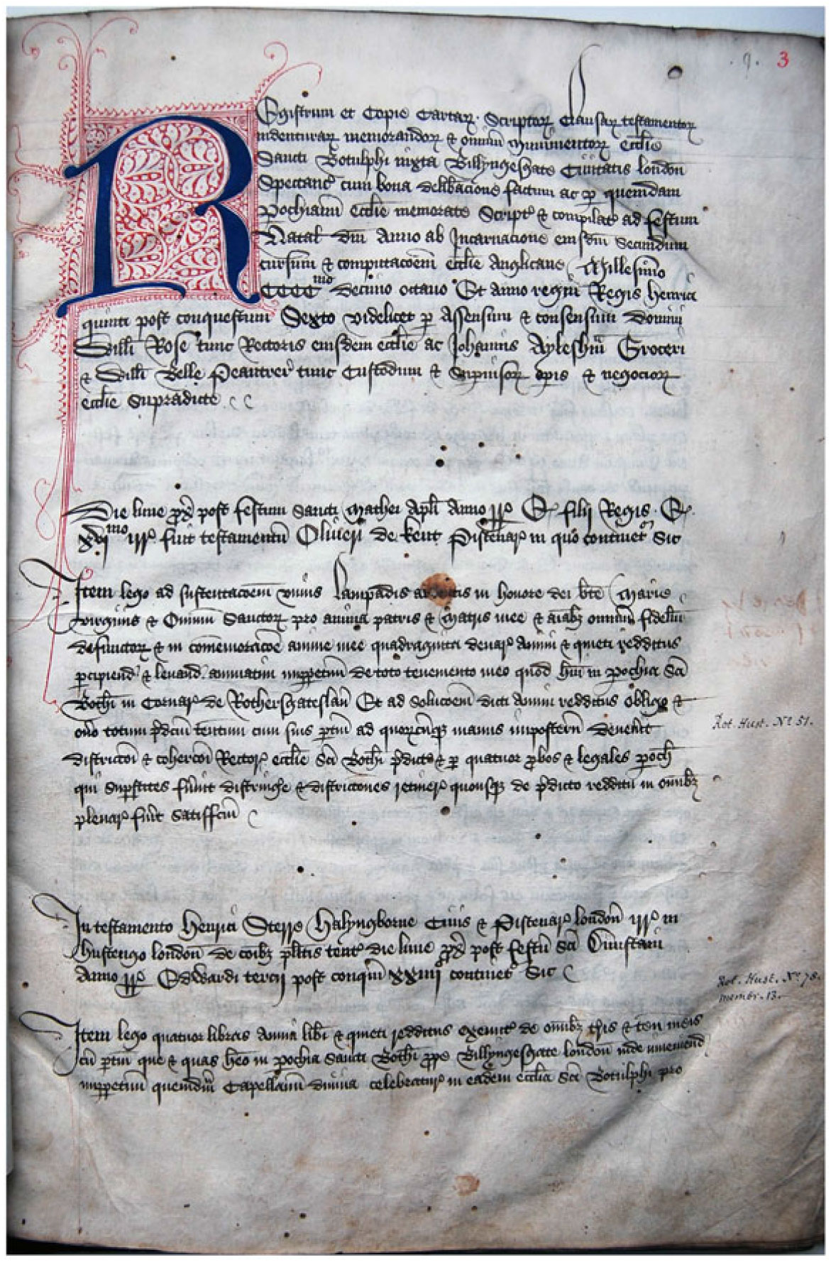
Many aspects of the internal features and decoration of the church can be reconstructed from two main documentary sources: a parish cartulary, begun in 1418; and vestry minutes and churchwardens’ accounts from the late sixteenth century up to the Great Fire.Footnote 35 Wills of parishioners of St Botolph’s survive from the early fourteenth century. Over 100 of them dating between 1313 and 1558 contain useful physical references to the interior of the church. Study of them reveals certain patterns. There were initially two altars, of St Mary and St Katherine. Some wills refer not to ‘St Mary’s altar’ but to ‘St Mary’s chapel’, but this need not indicate a distinct physical space as opposed to a simple altar. Both altars were probably against the buttresses either side of the chancel arch. At this date there were two parish fraternities, of St Mary and of St Katherine. The first half of the century seems the likeliest time for the expansion of the parish church; and at this time it produced its fine cartulary, which began in Christmas 1418, rehearsing wills of 1323 and 1350 (fig 18).
The opening page of the parish cartulary of St Botolph Billingsgate, commenced at Christmas 1418 (LMA, P69/BOT3/D/001/MS00059). The first two entries are extracts from Hustings wills enrolled in 1323 and 1350. Photograph: © John Schofield.

References to St Mary’s altar continue to at least 1420, but in 1413 comes a reference to what was apparently a new altar, that of St John the Baptist. In 1439 there is the first mention of a new fraternity, of the Virgin/St Mary and St John the Baptist. This is accompanied by the permanent disappearance of any further reference to the altar of St Katherine. These changes may be linked to the enlargement of the church to the south in the fifteenth century. A tantalising bequest in 1410 of twenty shillings (at a time when a skilled labourer earned 6d a day) to the fabric of the ‘new work’ (novi operis) of the church may refer to the infilling of the open space between the south wall of the early church and Reynewell’s house or warehouse.
On 23 January 1543, on the eve of the Reformation, William Lucar, priest, was appointed to the perpetual chantry of Thomas Snowdylonde, who had died in 1361, almost 200 years earlier. Snowdylonde had left various ornaments to St Mary’s chapel, as well as establishing the perpetual chantry for his own soul and for the welfare of the brethren of St Mary’s fraternity. Lucar was appointed, not by the parish priest or the churchwardens alone, but jointly by the churchwardens and the wardens of the Fraternity of the Virgin Mary and St John the Baptist, who together were stated to be the true patrons (veri patroni) of the chantry. This shows that the new altar and new fraternity were the reincarnation of the former altar, chapel and Fraternity of St Mary.
In 1443 John Reynewell granted his domus to trustees, including William Stafford. Such grants were a common tactic by donors wishing to grant land to a corporate owner without the expense of a licence in mortmain (from 1279, lands could not be bequeathed to an institution without royal authority). In 1456 Stafford, as the surviving trustee, conveyed it to the parish. At first sight, Reynewell’s grant in 1443 looks far too late for a new fraternity or altar mentioned in wills proved in 1439 or 1413, let alone 1410. However, the discrepancy is more apparent than real. We know of other conveyances to institutions where complex legal provisions designed to avoid a licence in mortmain lagged behind the new use of the site by a number of years. The new south aisle, built between Reynewell’s building and the church, could therefore be earlier than 1443, and have contained the new altar of St Mary and St John the Baptist. This altar and its fraternity are now mentioned continuously from 1439 until the Reformation. In 1471 there is the first mention of a Trinity altar.
In the 1540s, Wyngaerde shows the church comprised two separately roofed aisles, with the prominent tower at the west end of the north aisle. The southern of the two roofs must therefore have been above the extension. Wyngaerde ghosts in windows along its south side, so there were windows in the south wall of the church and D: Building 5 to the south (Reynewell’s house) must have had a lower roof. The precise way that Reynewell’s originally separate building was incorporated into the church is not known, and there are no clear documentary references to its use. The undercroft forming its lower storey was always a separate feature, entered only from the lane after it had been rebuilt with vaulting. The floor above, the main floor of the building, did not survive to be recorded. There was probably some form of access from the enveloping church. It is proposed here that the main room became some type of parish space, a long hall (or succession of rooms) equivalent in area to the three bays of the undercroft below. There is, however, no information on whether the building had, or then acquired, rooms above. The only London analogy for which there is graphic evidence is the hall of the Fraternity of the Trinity at St Botolph Aldersgate, which was established by 1389, possibly in 1377. This was a first-floor hall in a timber-framed range that belonged to the fraternity and was a short distance from the church in Aldersgate; its site is now covered by the roundabout at the junction of Aldersgate and London Wall highways.Footnote 36 So, at the Reformation the church comprised nave and chancel, with the high altar dedicated to St Botolph; a Trinity chapel (on its north side in 1537), perhaps against the buttress of the chancel arch, or against a later screen; a south aisle with an altar of St Mary and St John the Baptist; and on a raised level, some sort of fraternity hall with vestry beyond.
Five phases of activity are assigned to the period c 1500–1666. In period D15.3, the distinctive chequerwork on the east wall of the fifteenth-century extension was rendered over, and some kind of architectural feature, or panelling, placed against it, as suggested by a mark in the plaster. A new set of steps led from the body of the old church on the north into the extension, which was slightly lower. This phase is placed in the sixteenth century, but without accurate evidence; an argument could be made that the plastering is from before 1530, in which case the mark in the plaster could be from an altar and reredos. In period D16.2, the floor within the extension was raised by importing soil, and steps inserted in the doorway to the lane to access the new internal level; a new arcade was built between the north part of the church and the extension, and the east bay of the extension was probably partitioned off, or there was a new screen. This is proposed to be the documented rebuilding of the church in 1607–9. A pier base in the wall between the extension and Reynewell’s building suggests the common wall was rebuilt as another arcade, giving access to the space. Burials then followed in the extension, which was now the middle aisle of the church; so, they would have been in what was probably the chancel after 1455 – the most prestigious place for them.
The seismic changes to the internal appearance of London’s parish churches at the Reformation have been described and discussed many times. Images were being thrown out of London churches, some being pricked to see if they bled in October 1533.Footnote 37 The main purge was over a period of months in 1547: walls were whitewashed, pulpits replaced the communion table as the centre of the place and plain glass was put in the windows. All images and altar equipment were removed. Service books in Latin were sold and replaced by English books of psalms.Footnote 38 In the case of St Botolph’s, by 1600 the church was whitened but congested with galleries and pews. Its floor had been raised several times and by 1600 or shortly after the patches of medieval tiles, individually up to three centuries old, were replaced by larger plain tiles from the Low Countries. Now, as a result of the excavation and the associated documentary research, St Botolph Billingsgate joins the large group within the City’s 100+ medieval parish churches that have been investigated over the past century.Footnote 39
St Botolph’s did not have a churchyard or a cemetery until the 1390s. There would have been a few burials in the church, but these would have been a very small minority of rich or influential people. Where the great majority of its parishioners were buried is unknown. Perhaps the fact that the patron of the church was St Paul’s Cathedral, which acquired the church in the twelfth century by the gift of Orgar (Ordgar) the deacon, facilitated the use by the parish of the large cathedral churchyard. In 1392 Gilbert Maghfield (and other spellings), who owned Tenement 11 next to St Botolph’s church, and John Claveryng obtained a royal licence to grant to the parish a plot of land, a secular property, in Botolph Lane to be a cemetery. It lay about 80m up Botolph Lane on the other side of Thames Street, so nearby. This was dedicated in March 1393. Thereafter, presumably, most bodies were buried there.
Burials at St Botolph’s
Whatever the identity of the two people buried in the brick tombs in the church in the middle of the fifteenth century, in life they would have been privileged and important. In 1596 John Stow recorded that the church formerly contained many fair monuments, but ‘al destroyed by bad and greedy men of spoyle’. He had found records of the burials of Reynewell, Stephen Forstar, who was mayor in 1454, and his wife Agnes, and two sheriffs of 1423 and 1480.Footnote 40
The skeletal remains of sixty-nine individuals buried in the south part of St Botolph Billingsgate have been studied.Footnote 41 Six probably dated to the fifteenth century, and the rest to the first half of the seventeenth century. The most common pathological changes recorded were non-specific infection, seen predominately in the leg bones with periostitis and degenerative joint disease, including rotator cuff disease, osteoarthritis of load bearing joints and in the spine, as well as a case of gout and four individuals, all older males, affected by diffuse idiopathic skeletal hyperostosis (DISH), a condition no longer seen to be the liability to health it once was.Footnote 42 Other spinal joint diseases observed were osteophytosis and intervertebral disc disease, both of which increased in prevalence with age, and Schmorl’s nodes. There was a low rate of fracture trauma; one young male had a possible cranial blunt force trauma and two individuals had possible dislocation of joints. Soft tissue trauma was observed in five adults, with the majority affecting the legs and feet. The metabolic disorder of rickets was recorded both in children, with one child displaying active rickets at the time of their death, and in adults as residual rickets. Two females that had crania with post-mortem damage manifested the bony changes of hyperostosis frontalis interna (HFI) and one female possibly had bone changes associated with Paget’s disease. A number of congenital and developmental anomalies were recorded in the vertebrae, including scoliosis, spondylolysis, spina bifida occulta and vertebral border shifts. Two males had anomalies in their feet.
The dental health of the adult individuals followed a similar pattern in that with increasing age there was an increase in the build-up of dental calculus, periodontal disease and ante-mortem tooth loss. Carious lesions were observed, but they were not overall as gross and at such high rates as those recorded in the later post-medieval skeletal collections. All of the individuals affected with abscesses did have poor dental health and suffered from dental decay. Enamel hypoplasia was recorded in thirty of the individuals, indicating episodes of stress during their growth; it affected predominantly the canine and anterior teeth, a pattern often seen in post-medieval collections. The dental health of the children was fairly good; most had dental calculus and only two had caries in their deciduous dentition.
Skeleton D[783] is suggested to be that of John Reynewell, mayor in 1426–7, who died in 1445; his age at death is unknown. Analysis of his bones puts him in the ‘over 46’ group, and age estimation based on the pubic symphosis and auricular surfaces on the pelves would place him in his early sixties. His bones contained evidence of his rich eating habits, yet he also had iron deficiency anaemia. If this is Reynewell, he is one of the earliest named individuals from London to be identified in a grave and studied osteologically.
A lead seal D[983] from a papal document of Urban vi (1378–89), perhaps an indulgence, was found in the pebbly silt that covered his coffin, but this may not have been a part of his burial. His coffin may have been moved from the northern of the two brick chambers to lie in the southern – though why this should have happened cannot be ascertained. Two further papal seals, both of Gregory xi (1370–8), were found in later burial deposits in the church, and were presumably from other burials. These three seals, all of sometime in the narrow date range 1370–89, are about sixty years older than the earliest burials recorded in the excavated part of the church. Either they came from soil moved about in the building from fourteenth-century burials which lay outside the excavated area, or they were deliberately incorporated into the fifteenth-century burials, the belief being that the indulgences still had religious potency.
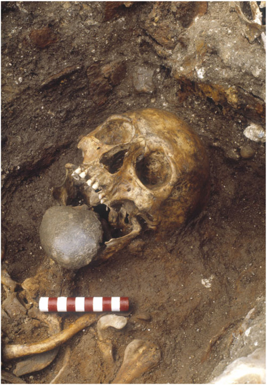
Two centuries later, the Great Plague of 1665 killed 69,000 people in London; another statistic sometimes quoted is that 20 per cent of the population died, which, if the two figures are put together, gives a total population for the London conurbation of 345,000. In St Botolph’s parish, the Bills of Mortality for 1665 state that eighty-three people were buried by the parish in that year, fifty of whom died of the plague. One excavated burial D[342] was of a man in a coffin on which the excavators traced the date ‘1665’ or ‘1666’ laid out in studs or nails. He had a large stone placed in his mouth (fig 19). This may have been to stop any miasmic vapours coming from him, though dead; according to beliefs of the time, contagion was spread by breathing.Footnote 43 A second burial, of a woman aged eighteen to twenty-five, had a layer of chalk in the grave. Placing the coffin on a layer of chalk was a very old practice, with similar examples found at the cemetery of St Nicholas Shambles (a small parish church north of Newgate Street in the eleventh or twelfth centuryFootnote 44). That individuals have gone to the trouble of laying out the chalk surely indicates that the practice held some significance; precisely what is unknown. In this particular case, the burial being in period D16.5, the woman could well have died of plague.
Billingsgate, period 16.5, skeleton [342] (male) with stone in mouth (100mm scale). Photograph: © MOLA.

FUTURE OPPORTUNITIES FOR RESEARCH
Thus far, this article has given an account of the archaeological results on these four sites for the period 1100 to 1666. Here, it seeks to outline some research possibilities for the future.
As a medieval port, London was not unique in the development of its waterfront. The variety of construction in stone and timber of waterfront structures is paralleled in other contemporary ports (many of which are shown on the map of contacts demonstrated through pottery of the period; see fig 7). Eleventh- and twelfth-century embankments and jetties, perhaps for commercial purposes, have been excavated in a number of sea and river ports in Britain, Ireland and on the Continent; for example, at Bristol (where in the second half of the twelfth century a waterfront area downstream of the town’s bridge was rapidly developed on the River Avon), Norwich, Dublin, Bergen (Norway; from the late twelfth century), Utrecht (Netherlands), Lübeck (Germany), Schleswig (Germany) and Gdańsk (Poland). These structures are mostly simple fences, sometimes supported by dumps of stone rubble and earth, and stone walls were perhaps rare: that of shortly before 1120 in Dublin was marvelled at. Hartlepool, on the north-east coast of England, has produced twelfth-century walls both along the shore and apparently jutting out into the water as jetties, and reclamation in Bristol in the twelfth and thirteenth centuries used stone walls. There are examples from excavations elsewhere in Europe, such as at Stralsund (Germany). Amsterdam emerged as a place after floods of 1170–93, with dams and dykes; its development as a town followed. In the Mediterranean, at Genoa, quayside walls, protuding jetties and a long mole were of stone from the twelfth century.Footnote 45 No doubt local circumstances of availability of materials affected the choice in most cases.Footnote 46
In several ports the timber walls with their bracing arrangements are strikingly similar to the London examples, though there are some local variations also. Stone quayside walls have been found in several places, even small ports. In Newcastle, stone walls may have been the general rule. A good deal of comparable work to that in London has been carried out in Hull, also over the last forty years. The waterfront along the River Hull, now excavated on several sites, was a similar strip of land reclaimed over centuries and eventually 80m wide. Timber revetments and fragments of boats, warehouses and industrial installations are often dated by dendrochronology, to an extent that matches the results in London.Footnote 47 Striking though these examples of reclamation in medieval British port towns (including London) may be, there is no evidence yet of a further stage of thinking about a city’s waterfront as is exemplified by comprehensive harbour works begun in 1260 at Genoa. Here, a new palazzo of the commune, today the Palazzo San Giorgio, was built on the waterfront along with stone quay walls and a mole. Genoa’s infrastructure was improved around what became its central piazza, the arcaded walks of the harbour.Footnote 48 The comparison of London’s waterfront to those of other British and Continental ports after 1500 largely remains to be done.Footnote 49
Overall for the medieval period, no other European city has demonstrated such an expansion into a waterway as that of London – a mile long, up to 100m wide. The excavations in this study form a starting-point for further study of the material culture of the whole City because of the wealth of information recovered and the length of the archaeological sequences recorded. Other future directions for research can be suggested. One is the river system of the Thames and its creeks, which formed a transport network feeding the central conurbation and vitalising the small communities along those creeks and contributory streams (fig 20). Revetments and walls improved the Thames as a major transport artery. On the north bank, revetments of some kind probably extended from Westminster to Blackwall by the fifteenth century. The roles and importance of secondary waterways as communication and distribution routes in the Middle Ages are not yet studied; one view is that of the minor rivers that fed into the Thames – during the first half of the seventeenth century only the Wey (to Guildford) and the Lea were navigable by commercial craft.Footnote 50 Records of traffic along the minor streams before 1600 have still to be brought together, if they can be found. The most important was the Lea, which was a route for supplies from Tottenham in the fourteenth century and presumably before.Footnote 51 It can be suggested that small rivers and creeks helped to make places, as at Chertsey, Croydon, Waltham Abbey and Barking. Roads and the Thames networked together: stone from the quarries at Reigate and Merstham in Surrey was carted to a wharf at Vauxhall and then transferred to barges for transport to royal and religious building projects at Westminster.Footnote 52 In this case it was apparently not worthwhile to use water transport for the first part of the stone’s journey. To summarise, the rich structural and artefactual evidence of the waterfront in the central conurbation should serve as a framework for what might be discovered at settlements and along river banks throughout the present Greater London area.
The River Thames and its contributory streams in the medieval period.
Drawing: © Mark Roughley.

Thames Street is now a large and peculiar archaeological asset. In 1708, Edward Hatton declared Thames Street to be ‘a most extraordinary, spacious street in London’.Footnote 53 Raised, levelled and partly widened, though still with bottlenecks (for example, at All Hallows the Great, where the new church built by Christopher Wren was probably on exactly the same footprint as its medieval predecessor), Thames Street was in 1700 an enhanced recreation of its former self before the Fire, an important and distinctive part of the post-Fire City. It was also an idea that could be exported, possibly even before 1666. When the English settlement of Port Royal (Jamaica) was established from 1658, several streets had names in imitation of those in London. There was a Queen Street, a Lime Street and a Tower Street (without a tower), but the longest street, along the considerable waterfront of Port Royal, was called Thames Street (though the name is not mentioned in documents until the 1680s) and it was 30ft (9.1m) wide.Footnote 54
Due to town planning after the Second World War, London’s Thames Street is today a thundering four-lane highway running through the City down by the waterfront, a sort of bypass comparable to similar arterial roads cutting off the waterfront from the wider city at Genoa and Naples. Archaeological work and associated documentary research is restoring to our sight this once important street, the capital’s gateway to the world. Because the street has been widened in stages, almost always on the north side, the present north carriageway lies over the medieval, and probably late Anglo-Saxon, street frontage for a long distance. This will be intact. And partly because of the raising of the street surface after the Fire, deposits beneath the street are deep; outside St Magnus church, 9.5m deep to the earliest Roman river silts, which are full of finds.Footnote 55
For the pottery and artefacts of 1100 to 1450 that are the subject of this article, there are many avenues to explore. There could be further specific catalogues of coins (including jettons and tokens), weaponry and industrial equipment. The two centuries after c 1450 have also produced many artefacts, but they have not yet been studied from these sites. Any new research on artefacts would have to take account of all the similar material that has been dug up since the 1990s.Footnote 56
There is an underlying assumption that the archaeological archive of site records and finds at the Museum of London will remain accessible for future interrogation, using the main report and this paper as entry points. This archive contains nearly all the archaeological material excavated in the City and Greater London since the beginning of the twentieth century; by volume, most of it has been assembled by hundreds of archaeologists working on London sites since the 1970s.Footnote 57 Only since the 1990s can the degree of access to sites in London by archaeologists be considered adequate. As this paper has demonstrated, the research and publication on deep urban sites of the 1970s and 1980s lays the foundation for research and research questions in the future.
ACKNOWLEDGEMENTS
This research and work for publication has been carried out by many people besides the author: Jelena Bekvalac, Ian Betts, Lyn Blackmore, John Clark, Tony Dyson, Stephen Freeth, Helen Ganiaris, Suzanne Keene, Sabine K Klaus and Jacqui Pearce. The excavations and post-excavation work (the latter undertaken at intervals since the 1970s) was funded by the Department of the Environment, the Manpower Commission, the Corporation of London, the City of London Archaeological Trust, the Museum of London, the Dyers’ Company, the Fishmongers’ Company, the Girdlers’ Company and the Grocers’ Company; and the publication stages by the Marc Fitch Fund. The author would like to thank David Evans, for information on Hull, and Roger Leech and Bob Jones, for information on Bristol, which is incorporated here.
ABBREVIATIONS AND BIBLIOGRAPHY
Abbreviations
- LMA
London Metropolitan Archives, London
- MOLA
Museum of London Archaeology, London
- MoLAS
Museum of London Archaeology Service (1990 to 2009; thereafter Museum of London Archaeology)