


Introduction
Despite a period of deforestation, Latin America’s woodlands have recovered following unexpected dynamics since 2000. According to Fearnside (Reference Fearnside and Shugart2017), the rate of deforestation in the Brazilian Amazon fell from 27,772 km2/year in 2004 to 4,571 km2/year in 2012 (see also Hecht, Reference Hecht2014a: 881).Footnote 1 This pattern was also recorded in other places of Amazonia and Central America. Jadin et al. (Reference Jadin, Meyfroidt and Lambin2016) stress that while tropical deforestation remains widespread, some countries have experienced a forest transition.Footnote 2 According to Meyfroidt and Lambin (Reference Meyfroidt and Lambin2011), despite global rates of tropical deforestation remaining high, they also experienced a decline during the period 2000–10. In this context, some developing countries have undergone a forest transition due its natural regeneration and the expansion of forest plantations, thus contributing to net global reforestation and diminishing pressure on woodlands. However, the environmental benefit of this process has been disputed in recent years for not taking into account the ecological quality of the forest transition associated with increased exports of agricultural and forest products. In this regard, the analysis of the impact of international policies in reducing global deforestation must consider the international trade of agricultural and forestry commodities (Meyfroidt, Rudel and Lambin, Reference Meyfroidt, Rudel and Lambin2010).
Reforestation, as well as natural forest regeneration, have also been widespread in the Latin American tropics. This region regained 360,000 km2 of woody vegetation cover in the early 2000s (Aide et al., Reference Aide, Clark, Grau, López-Carr, Levy, Redo, Bonilla-Moheno, Riner, Andrade-Nunez and Muniz2013; Clark et al., Reference Clark, Aide and Riner2013). Notably, deforested countries such as El Salvador also underwent a process of forest recovery during the same period (Hecht and Saatchi, Reference Hecht and Saatchi2007). As stated by Grainger, forest plantations doubled in Latin America between 1980 and 2005 (Grainger, Reference Grainger, Hecht, Padoch and Morrison2014: 93–4). According to Hetch (Reference Hecht2014a), these developments have led to significant transformations in Latin America’s agrarian realities, rural areas and policies. These changes imply that previous models for understanding small-farmer dynamics in the region need to be adjusted in order to focus ‘less on agriculture and more on emergent forest regimes, and in many ways a new, increasingly globalised economic and policy landscape that emphasises woodlands’ (Hecht, Reference Hecht2014a: 877).
In this regard, the incorporation of environmental dimensions within the agrarian question provides room for ‘a fruitful dialogue’ between political ecologists and researchers on agrarian studies (Gerber and Veuthey, Reference Gerber and Veuthey2010). Although critics have been calling for an exchange between political ecology and agrarian studies (Bernstein and Byres, Reference Bernstein and Byres2001), a gap still remains between these fields of study, as well as with peasants studies (Gerber and Veuthey, Reference Gerber and Veuthey2010). According to Benjaminsen and Svarstad (Reference Benjaminsen and Svarstad2019), political ecology is a field within environmental studies focused on power relations as well as the coproduction of nature and society. Blaikie and Brookfield (Reference Blaikie and Brookfield1987) further define political ecology as a field of study that combines the concerns of ecology with political economy in a broad sense (See also Wolf, Reference Wolf1972). Martínez-Alier (Reference Martínez-Alier2002) describes the field as the evaluation of conflicts over access to natural resources and services and over the problems of inequalities in terms of power, property and income among human groups. Peet and Watts (Reference Peet, Watts, Peet and Watts1996) added a new perspective, which addresses the social and power relations underlying environmental degradation. Overall, the relationship between political ecology, agrarian conflicts and environmental studies becomes quite clear in all of these analyses and it is particularly significant for Costa Rica’s case.Footnote 3
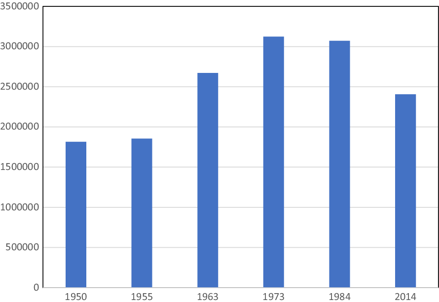
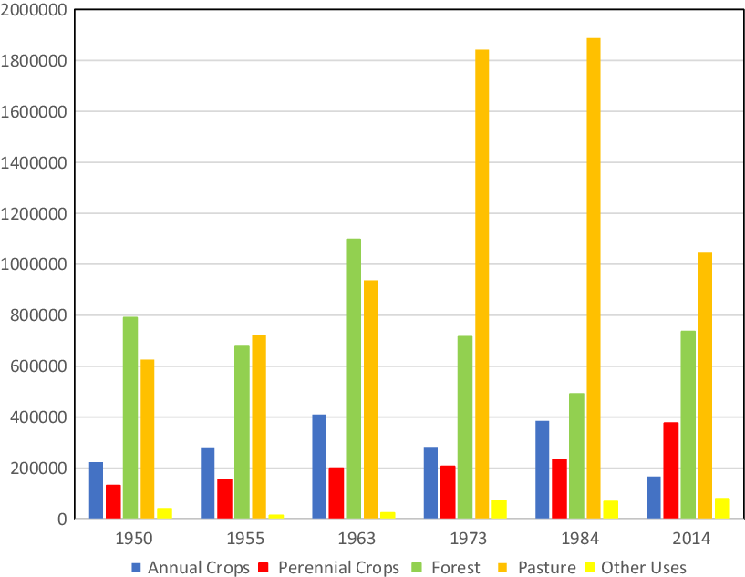
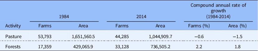
Despite high rates of deforestation during the 1970s and 1980s, Costa Rica is currently among a handful of countries where a net increase and stabilisation of forest cover have taken place in recent decades (de Camino Velozo, Villalobos and Morales Aymerich, Reference de Camino Velozo, Villalobos and Morales Aymerich2015). From the 1950s to the early 1980s, Costa Rica experienced a period of deforestation as the minimum coverage fell to approximately 21–30 per cent of the national territoryFootnote 4 (López, Reference López2021). According to de Camino Velozo, Villalobos and Morales Aymerich (Reference de Camino Velozo, Villalobos and Morales Aymerich2015), the primary cause of deforestation was the substitution of forest area by other land uses, mainly for agriculture and pastureland. As stated by Jadin et al. (Reference Jadin, Meyfroidt and Lambin2016), forest transition in Costa Rica took place due to the intensification of export-led agriculture, as well as to reforestation. The decline in meat exports led to a decrease in pastures, freeing up large plots of land for forest natural recovery, while grain imports have saved land for tropical fruits and oil palm production (See Appendices 1–4). Although the forest transition in Costa Rica has been environmentally beneficial, the expansion of export-oriented farmland has encouraged deforestation in some regions of high ecological value. In addition to this, the production of pallets used for export-led fruit increased timber extraction from forest plantations (Jadin et al., Reference Jadin, Meyfroidt and Lambin2016).
This article examines how the transformations in land tenure and forest conservation policies have led to the structuring of a ‘new agrarian question’ in Costa Rica linked to land concentration and the distribution of the so-called Payments for Environmental Services Program (hereafter PES). Despite the many studies on the subject, the connection between forest conservation (or forest transition as mentioned above) and the agrarian question has been neglected. In contrast to studies focusing on the analysis of latifundia Footnote 5 and their relationship with postwar livestock expansion, this article bridges more recent literature on forest conservation in Costa Rica to the agrarian question by exploring three dimensions. First, it examines the territorial change experienced in the Costa Rican countryside between 1950 and the 1970s, linked to the expansion of pastures and deforestation. Second, it identifies the contradictions underlying state policy that sought, on the one hand, to mitigate and control the extension of pastures and the process of deforestation, and on the other hand, to quell the social unrest through the creation of national parks and peasant settlements. Finally, the article discusses the recovery of forests in the national territory since the 1990s.Footnote 6
From forest to pasture: the perception of Costa Rica as a great grassland
Scholars have been analysing land concentration in Costa Rica since the 1970s. Between the late 1970s and the 1990s, the literature explored the dualism of the latifundia-minifundia land tenure structure as well as the framework and intensification of land conflicts (Barahona, Reference Barahona1980; Boza, Reference Boza1978; Churnside, Reference Churnside1981; Edelman and Seligson, Reference Edelman and Seligson1994; Edelman, Reference Edelman1992; González, Reference González1987; Mora, Reference Mora1990; Ramírez, Reference Ramírez1981; Rodríguez, Reference Rodríguez1988; Villarreal, Reference Villarreal1992). By and large, these studies demonstrated land concentration in large properties since the Second World War in Costa Rica. These scholars questioned the idea of Costa Rica as the ‘country of the minufundio’, as certain official mythology claimed (for instance Gudmundson, Reference Gudmundson2011; Molina, Reference Molina1986; Hill, Reference Hill1964; Rojas and Escoto, Reference Rojas and Escoto1960). Many of these studies identified latifundia as the unit causing land concentration and deforestation in Costa Rica. In both cases, grasslands were symbolically regarded as the basic component of an old social structure surviving postwar capitalist modernisation, associated with latifundia and the power of landowners. At the same time, from an ecological perspective, grassland was associated with the depredation of natural resources caused by livestock and meat demands from developed countries.
During the 1970s, the process of deforestation in Costa Rica attracted the attention of national and international scholars.Footnote 7 Among them, M. E. Bozzoli, J. J. Parsons and J. A. Tosi warned about the ‘potrerización’ of the national territory.Footnote 8 Bozzoli demonstrated that pastures constituted the dominant land use in almost the entire national territory (Bozzoli, Reference Bozzoli1977, based on agricultural census data). Bozzoli (Reference Bozzoli1977: 571) also pointed out that ‘the conversion of Costa Rica into a pasture’ was a process that was developed over a period of about twenty years. Unless adequate measures were taken, if this trend was maintained ‘the whole forest will have disappeared’ within fifteen years. This anthropological analysis went further than territorial or ecological matters and indicated that livestock expansion had a clear social impact, consisting in the displacement and migration of rural populations, as well as the concentration of land in few hands. According to Bozzoli (Reference Bozzoli1977: 571–2), this expansion strengthened a rural elite linked to meat exports and limited other production opportunities for peasants, tenants and family farmers.
Although Parsons (Reference Parsons1976) and Tosi (Reference Tosi1976) focused on the ecological dimension, they also revealed the contradictions of grasslands expansion. Parsons (Reference Parsons1976) stressed that this process was associated in Central America with the increasing use of cultivated pastures that were in many cases related to plants brought from Africa at the turn of the twentieth century. According to Parsons (Reference Parsons1976), potrerización was so deeply enrooted in the region that the agricultural frontier was only a transitory stage between forest elimination and the opening of pastures for livestock. From a social perspective this process was evidently contradictory. Whereas the area of pastures and cattle herd in Costa Rica doubled from 1959 to 1972, the same period witnessed a decline in meat consumption per capita (Parsons, Reference Parsons1976: 124–5; Kaimowitz, Reference Kaimowitz1996: 30–1). Parsons (Reference Parsons1976) further stressed that the ecological consequences of transforming forests into grasslands were poorly understood. The spread of African-native grassland improved the availability of fodder for livestock. However, this process resulted from the colonisation of aggressive species such as Jaragua (hyparrhenia rufa – nees – stapf), which became known as the ‘Africanisation’ of Central America’s tropical landscape (Parsons, Reference Parsons1976: 130–1).
Tosi (Reference Tosi1976: 139–41) also focused on the forest problem and stated that: ‘Our concern with the scope, severity and rates of unfavourable ecological changes in our environment can be largely attributed, directly or indirectly, to the senseless and unbridled expansion of traditional livestock to lands less suitable for this activity’ (Tosi, Reference Tosi1976: 139). Tosi was especially concerned about the waste of wood generated by pastures; a waste in terms of size and quality that would be difficult to recover in the future (Tosi, Reference Tosi1976: 140). He further claimed that a significant part of the felled forests formed part of ‘advanced successional stages’, with a high content of woods in large trunks. These species did not adapt easily to reproduction on degraded or ancient grazing soils.
To sum up, the projection of Costa Rica as ‘a great grassland’ was not far from becoming a reality (see Appendix 1). In 1978, the estimated linear rate of deforestation in the country was nearly 36,000 hectares per year (from 1950 to 1961), a figure that increased to 45,000 hectares from 1961 to 1977 (Pérez and Protti, Reference Pérez and Protti1978). Cross-referenced with data provided by Porras and Villarreal (Reference Porras and Villarreal1993), these figures show that most of this logging process was illegal. In 1977, the national total area legally exploited (through licences) was only 19,348 hectares (Porras and Villarreal, Reference Porras and Villarreal1993: 44). Increased logging also gave rise to the relocation of the forest frontier. Pérez and Protti (Reference Pérez and Protti1978) demonstrated that during the 1950s logging was concentrated in the Central and North Pacific regions, but it spread to the Caribbean and the northern and southern regions from 1961 to the 1970s. The shift in land uses that resulted from grassland expansion and logging activities clearly affected peasants in rural Costa Rica.
Identifying the causes of deforestation: the anti-ecological peasants
Whereas pastures increased their cover by about one-third during the period 1963–73, forests lost almost 400,000 hectares during the same period (Porras and Villarreal, Reference Porras and Villarreal1993: 16–17). Despite these trends, scholars have not reached a consensus regarding the quantification of the rate and causes of deforestation. Joyce’s data suggested an annual disappearance of about 50,000 hectares of forest, while González and Hatshorn indicated an average of between 25,000 and 60,000 hectares per year (cited by: Rodríguez and Vargas, Reference Rodríguez and Vargas1988: 17–19; Sader and Joyce, Reference Sader and Joyce1988; Joyce, Reference Joyce2006: 127–30). Within this context, the notion of deforestation associated with peasant pressures and land invaders prevailed among forest extraction companies and international organisations. However, other positions proposed an alternative reading, linking forest conversion into pastureland to the growth of meat demands from the United States and the so-called ‘Hamburger Connection’ (Myres, Reference Myres1981; Edelman, Reference Edelman1992).
Precaristas Footnote 9 and peasants on the agricultural frontier were generally singled out as the main contributors to forest logging. A 1983 report claimed that ‘precaristas continue to invade both public and private lands with impunity’, encompassing forest reserves and expanding their predatory occupation (cited by: Rodríguez and Vargas, Reference Rodríguez and Vargas1988: 33). At the beginning of the 1980s, an industrialist from the logging sector stated that ‘peasants not only commonly usurp land with traditional agricultural plantations, but they also specialise in irrationally destroying our forests’ (cited by: Rodríguez and Vargas, Reference Rodríguez and Vargas1988: 34). Ten years later, a renowned pioneer of Forest Conservation in Costa Rica maintained the same position: ‘Of course, peasants should not be blamed directly for this action, since they seek subsistence, but they are deforesting agents, which in many cases sell their plots to landowners when they lose their initial potential, migrate to new lands and continue with their activity’ (Fournier, Reference Fournier1991: 71).
The idea of the ‘anti-ecological’ peasantry was also patent in the founding history of Costa Rica’s national parks, which highlighted the role of the state as a preservationist agent coupled with the relevant role of officials and scientists (Boza, Reference Boza1978, Reference Boza1993, Reference Boza2015; Wallace, Reference Wallace1992; Allen, Reference Allen2001). This narrative labelled the peasant as an enemy of conservation.Footnote 10 It also described the peasant as an invader of haciendas and forests, as well as the broker between the interests of logging and cattle raisers. According to Ramírez and Maldonado (Reference Ramírez and Maldonado1988: 88), ‘the greatest threat to the integrity of wilderness areas are land invasions by a diverse group of actors …: “precaristas” or landless peasants, land speculators, loggers paying third parties to invade land in order to extract timber from farms, [and] cattle raisers attempting to expand the area of pastures …’.
Meanwhile, other accounts portray the peasants on the agricultural frontier as the main agents of deforestation, blaming them for the endangerment of protected areas. In their view, the peasantry cut down the forest to demonstrate that improvements (‘Mejoras’)Footnote 11 have been made to the property in order to claim its ownership. Peasants then sowed corn and other crops such as beans, which, as their yields dropped over the years, were replaced by pastures and livestock, facilitating soil degradation (Umaña, Reference Umaña1987: 32). This idea of land degradation prevailed until the 1990s. A study conducted in the 1990s stated that: ‘The pace of agricultural colonisation is unsustainable … Costa Rica has only 51,000 km2, and practically the agricultural frontier has reached its boundaries.’ Land under forest cover was not suitable for productive activities other than the protection of water resources, scenery, or biodiversity. However, ‘the pressure to colonise new areas continues, without considering its high social, economic and environmental costs’ (Ministerio de Recursos Naturales, Energía y Minas, 1990).
The debate on deforestation addressed the problem of land tenure in Costa Rica in two ways. The logging industry, international organisation officials and the state associated forest logging with peasant agriculture. In their view, deforestation and peasant land tenure were intertwined, while opposing the conservationist and developmental state policies. However, different scholars suggested that the deforestation was related to livestock expansion and therefore had an evident impact on the land tenure structure, favouring the formation of pastures and large livestock properties, usually in the hands of well-off social groups. As Bozzoli (Reference Bozzoli1977) pointed out, behind the potrerización of the national territory there was both an ecological and social cost, stemming from land concentration and the expulsion of peasants from livestock regions, who headed towards urban or other areas of the country.
To sum up, both positions simplified the causes of deforestation. Neither the pasture nor the peasantry were the sole culprits of deforestation. On the one hand, deforestation and reforestation were developed as part of intense commercial activity, in both legal and illegal contexts, related to the presence of medium and large-scale farmers and businessmen. In the case of legal logging, most of the forest logging permits assigned in the 1970s and 1980s were concentrated in farms of over 100 hectares. Likewise, most of the area reforested through state incentives was concentrated in these types of properties (Rodríguez and Vargas, Reference Rodríguez and Vargas1988: 88–92). On the other hand, since the formation of the Instituto de Tierras y Colonización (hereafter ITCO)Footnote 12 peasant settlement deforestation seemed to increase, as in 1986 the state had bought and accumulated 600,000 hectares for these settlements (Mora, Reference Mora1990: 97).
Bringing back the woodlands: the state, peasant settlements and national parks
In the early 1970s, one of the state’s main responses to potrerización and deforestation was the creation of protected areas such as national parks, as well as biological and forest reserves. Influenced by American conservationist tradition, the creation of these areas helped to contain accelerated deforestation (López and Granados, Reference López and Granados2016). At the same time, the state had to deal with the social effects of land concentration around livestock; particularly the impoverishment of the rural population and its proletarianisation. Increasing land demands, social unrest and rural conflicts arose among former peasants and landless workers.Footnote 13 These tensions forced the Costa Rican government to create a programme based on the distribution of plots for peasant settlements, administered by ITCO. From an analytical perspective, ecological and land tenure policies shared a common basis: the creation of sites of ecological and social restoration. On the one hand, the establishment of national parks sought to curb grassland expansion and to recover forests affected by logging. On the other hand, peasant settlements sought to contain social conflicts derived from the unequal land structure associated with grassland expansion. Thus, the state also attempted to localise and contain social conflicts in specific sectors of the country.
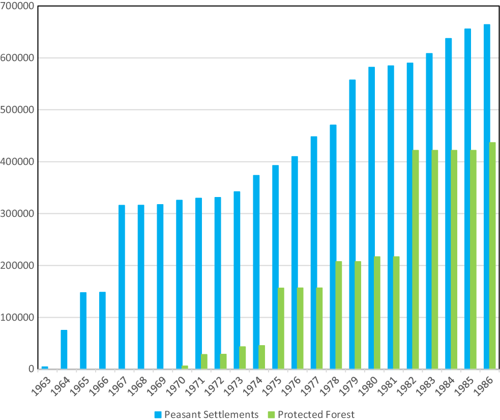
From 1970 to 1973, the protected areas covered an area of approximately 43,000 hectares. The increase was even more significant during the administration of President Daniel Oduber (1974–78), which incorporated into the National Park System new areas such as Chirripó and Corcovado (in the south of the country) as well as a significant number of forest reserves and wildlife refuges (Rodríguez and Vargas, Reference Rodríguez and Vargas1988: 168–72; Joyce, Reference Joyce2006: 160).Footnote 14 The governments of Carazo Odio (1978–82) and Monge Álvarez (1982–6) continued these trends and in 1986 almost half a million hectares were protected. These protected zones were consolidated during the 1990s and the early 2000s. By 2012, more than 1.3 million hectares had some form of protection, of which just over 600,000 were national parks, 200,000 national wildlife refuges and many forest reserves. The rest was distributed among wetlands, protected areas, biological reserves, or nature reserves.Footnote 15
However, these achievements took place during a period of rising conflicts between precaristas, landowners and the state due to the concentration of land and agricultural resources. The modernisation of rice farming on the Pacific Coast led to the concentration of land and capital by medium and large producers (Cartín and Piszk, Reference Cartín and Piszk1988; Matamoros, Reference Matamoros1985). With regard to coffee production, while the Green Revolution technology made family farming profitable, it also excluded producers who failed to modernise their farms (Raventós, Reference Raventós1986). The same trends intensified in other regions such as the Guanacaste province where capitalist modernisation and aggravating land concentration led to the disappearance of peasants who became hired workers, worsening the land problem (Rodríguez, Reference Rodríguez1988).
From 1963 to 1979, different groups of peasants invaded more than 700,000 hectares, while during the period 1980–5 invasions affected approximately 120,000 hectares (Villarreal, Reference Villarreal1992). In 1970, ITCO registered up to 817 occupied farms that covered about 400,000 hectares (Grupo Centroamericano de Tenencia de la Tierra y Desarrollo Rural, 1969; Barahona, Reference Barahona1980). In this context, state intervention was required as the ITCO coordinated the purchase of more than 4,000 hectares, for a total of 324 beneficiary families in 1963. In 1986, the accumulated area of land purchased by ITCO was approximately 663,000 hectares, for more than 32,000 beneficiary families (Mora, Reference Mora1990: 97). The territorial impact of forest conservation and land settlement policies was notorious. In 1986, peasant settlements and protected forests accounted for approximately 35 per cent of the national agricultural area according to the 1984 Agricultural Census. In other words, one third of Costa Rica’s effectively available land had been converted to other uses in the span of a decade, driven by both state ‘conservationism’ and social conflict in the countryside (see Appendix 2).
Is forest the new grassland? Towards a ‘second generation’ land tenure
As shown by studies, tropical forests are currently valued for their potential for carbon capture and sequestration. Developed in 2005, REDD+ is a global strategy for the reduction of greenhouse gas emissions through forest management in developing countries. REDD+ projects support policies that address the causes of deforestation, promote social and economic development, improve the conservation and sustainable management of natural resources, and increase carbon stocks as well.Footnote 16 Despite their environmental advantages, initiatives linked to the REDD+, such as the payment for environmental services, have been questioned by different experts. On the one hand, as stated by Fletcher et al. (Reference Fletcher, Dressler, Anderson and Büscher2019), these programmes encourage the preservation of forest by farmers through market-based instruments, as part of a ‘neoliberalisation’ trend in forest management. Thus, by failing to deliver sufficient revenue from the incentives, these initiatives led to the extraction of natural resources (Fletcher et al., Reference Fletcher, Dressler, Anderson and Büscher2019: 1069; Fletcher, Reference Fletcher, Roger, Held and Nag2013). On the other hand, given that land ownership is a determining condition to participate in payment for environmental services, these initiatives exclude landless farmers settled in regions with unclear land tenure rights (Greenleaf, Reference Greenleaf2020).
The first environmental incentives in Costa Rica were created in the 1970s, when the state established a tax incentive to promote reforestation projects, while in the early 1980s, it launched an income tax deduction mechanism with the same purpose (Rodríguez and Vargas, Reference Rodríguez and Vargas1988: 82–95; Segura, Reference Segura1992; Porras and Villarreal, Reference Porras and Villarreal1993: 79–99). The Certificado de Abono Forestal (CAF) was a credit certificate issued by the state in the 1980s and negotiable in the financial market. In the late 1980s, the Certificado de Abono Forestal para el Manejo de Bosques was issued and sought to improve the technical management of woodlands (Ortiz, Reference Ortiz2004). Similarly, a series of certificates for small-scale reforestation producers emerged, such as the Certificado de Abono Forestal por Adelantado (CAFA) and the Fondo de Desarrollo Forestal (FDF); the latter was funded by Netherlands, Sweden and Finland. In the 1990s, the first carbon sales were finally made with Nordic countries (Camacho and Solano, Reference Camacho and Solano2010). In 1995, the accumulated number of hectares covered by these incentives (and others not referred to here) was approximately 139,000 hectares (González and Lobo, Reference González, Lobo, Kleinn and Davis1999).
In the early 2000s, Costa Rica also became one of the first countries to meet its international commitment to preserve lands and water sources through a funding initiative known as Forever Costa Rica (a debt-for-nature-swap brokered by the Costa Rican government and The Nature Conservancy with the US Treasury). This initiative has secured more than US $50 million to strengthen and expand the country’s network of national parks and protected areas.Footnote 17 Considering Costa Rica’s extensive support for forest and nature conservation, what have been the results in terms of forest land distribution/structure?
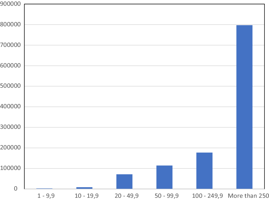
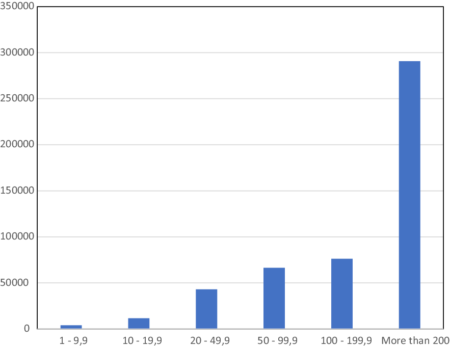
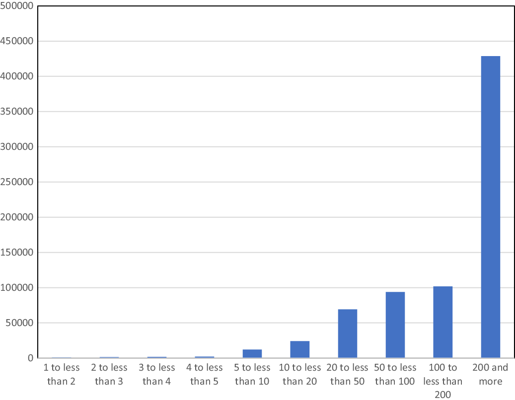
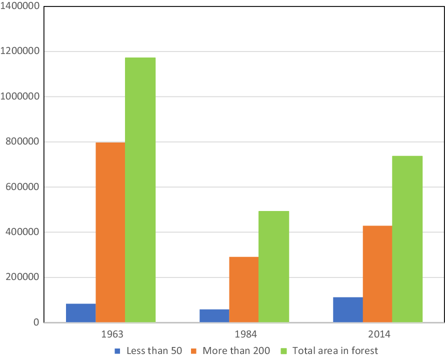
According to the 1963 Agricultural Census, of the total hectares covered by forests (1,171,663.2 hectares), 68 per cent was occupied by farms larger than 250 hectares, while only just over 1 per cent of the forests corresponded to farms smaller than 20 hectares. This distribution had barely changed two decades later. According to the 1984 Agricultural Census, whereas 59 per cent of forests were located within farms of more than 250 hectares, just over 3 per cent were located within properties smaller than 20 hectares (see Appendix 3). The 2014 Agricultural Census is especially useful for examining the changes that have occurred since 1963. The area covered by forests in 2014 experienced an increase after 1984, although the area is still lower than in 1963. Between 1984 and 2014, the forests increased their cover by approximately 244,000 hectares. However, this increase still does not reach the one million hectares of forest that existed in the early 1960s. The 2014 data also reveal the persistence of land concentration in forests (see Appendix 4). Farms of over 200 hectares comprise 58 per cent of the total land, while properties smaller than 50 hectares occupy only 15 per cent of the total. In comparison with 1984, farms of less than 50 hectares have doubled, but farms of more than 200 hectares have also increased by almost 70 per cent (INEC, 2015). Therefore, the forest recovery shown in the census data is the result of an increase in the number of small and medium scale farms as well as properties larger than 200 hectares. Thus, Costa Rican woodlands have been monopolised by protected areas and large forests in private hands.
Land concentration in forests also reveals a territorial transformation in Costa Rica that does not necessarily have positive social implications. It rather shows the appropriation of resources by different social groups.Footnote 18 As mentioned above, Costa Rica has developed a significant forest and environmental protection and incentives framework (institutionalised by REDD+ and also based on ‘debt-for-nature’ swaps), giving rise to a second level of land concentration; a ‘second-generation’ land tenure associated with the appropriation of such incentives by medium or large landowners (Ortiz, Reference Ortiz2004). These incentives were established through the Payment for Environmental Services Program, under Forest Law 7575 (1996) and coordinated by FONAFIFO (Sánchez and Navarrete, Reference Sánchez and Navarrete2017).Footnote 19 The goal of the programme is forest recovery and conservation in the country through financial incentives based on a four-goal framework: first, the mitigation of greenhouse gas emissions; second, water protection for rural and urban or hydroelectric use; third, biodiversity conservation and fourth, natural landscape and scenic protection. PES are based on five-year contracts with private landowners, NGOs, women farm owners, and indigenous communities. FONAFIFO makes annual payments per hectare conserved or subject to other established schemes within the framework of a five-year contract.Footnote 20 Rather than an incentive or a subsidy, the PES is a strategy of ‘economic recognition’ to landowners for forest conservation (or reforestation). Therefore, they constitute a practice of economic, social and ecological valuation of the forest (Sánchez and Navarrete, Reference Sánchez and Navarrete2017).Footnote 21
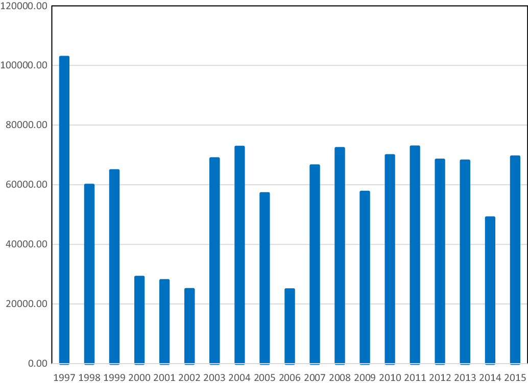
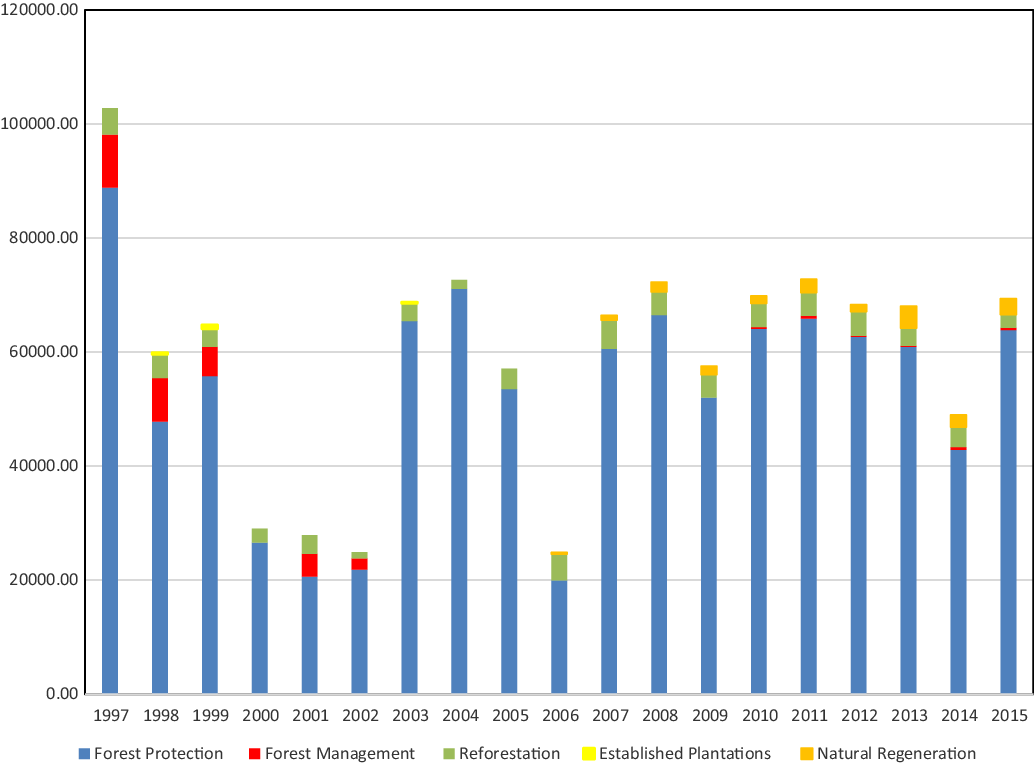
In summary, from 1997 to 2015, the area covered by PES ranged between 100,000 hectares in the first year and close to 69,000 hectares in 2015. Overall, in this period, the programme covered more than 1.1 million hectares.Footnote 22 In terms of the distribution of resources by type of protection, most of the resources were allocated to ‘Forest Protection’ which accounted for more than 80 per cent of the funds. Finally, data on the protected area within each farm indicate a phenomenon of payments concentration in properties between 100 and 300 hectares. Although just over half of the contracts are for areas of less than 50 hectares, most of the area covered by the payments is concentrated in projects of 100 to 300 hectares (46 per cent) and more than 300 hectares (18 per cent) (see Appendix 5).Footnote 23
Conclusions
Although Costa Rica is regarded worldwide as a paradigmatic case of forest restoration, the history of this process has remained little known. The country’s forest conservation policies were created at a time of social and environmental crises, characterised by conflicts between the state and poor/landless peasants. Between the 1960s and 1980s, Costa Rica had one of the highest rates of deforestation in the world, caused by first, the expansion of pastures for cattle-raising, and second, forest clearing for the sale of timber on national and international markets. At the same time, the country experienced a social crisis in those decades due to the invasion of private and state land by thousands of poor and landless peasants. Many of these peasants had been displaced from their land by the expansion of latifundia and the effect of the adoption of the Green Revolution, becoming ‘precaristas’. The state reacted to both crises by creating the national park system and ITCO. Both institutions, albeit with different goals, labelled the poor peasant as an anti-ecological agent, pointing to him as the culprit of deforestation, as well as an anti-democratic agent, a land invader, who disrespected private property.
As in other Latin American countries, in Costa Rica, latifundia monopolised most of the land between the 1960s and 1980s. However, the forest was also a space dominated by large landowners, as evidenced by the agricultural censuses of the time. In the 1980s, most of the land covered by forest belonged to large farms upper than 200 hectares in size; a trend that continued until 2014. In other words, during the period under study, Costa Rica’s forests were never in the hands of peasants. Forest concentration in large farms demonstrates that the model of forest conservation in Costa Rica (although successful) has not extended land access to peasants and medium-sized farmers. In this context, the development of PES has created a second type of resource concentration, distributing most of the payments among medium and large farms. This trend suggests that the classic agrarian question, focused on the problem of latifundia and its relationship with cattle-raising has been transformed into a new agrarian question, concentrated on the commodification of forests. Although this is only a hypothesis, the case of Costa Rica demonstrates that forest conservation policies, beyond their ecological impact, have been constructed on a social reality characterised by economic inequality and the problem of land access for the poorest (Greenleaf, Reference Greenleaf2020).
Costa Rica is a useful case for rethinking the histories and narratives of Latin America’s forest conservation and land tenure. Given that forest conservation policy coexisted with land reform policy in Costa Rica, conservationist institutions often clashed with land distribution institutions, evidencing different cultures and conceptions of forest and land use. Therefore, new power relations emerged within the Costa Rican state: while agrarian reform was questioned by the conservative elite for its anti-democratic and communist character, forest conservation gained state support thanks to its apolitical character. While precaristas lost legitimacy among state and the elite for ‘encroaching’ on private property, conservationists gained the state’s favour due to their status as scientists and experts.
In order to have a better grasp of the history of forest conservation, we need to take into account the study of land tenure while the history of agrarian reform would improve by understanding the dynamics of the ecologic question (Hecht, Reference Hecht2014b; Hecht and Saatchi, Reference Hecht and Saatchi2007). On the one hand, it is necessary to question the heroic narratives written ‘from above’ that highlight the role of scientists and public officials in the creation of protected areas while erasing the history of peasants and indigenous people. As Jacoby suggests, it is essential to understand and describe alternative narratives developed ‘from below’. On the other hand, the history of conflicts between conservationists, peasants and indigenous people becomes an essential perspective in rewriting the history of Latin America’s agrarian reform. Both narratives will improve their analyses by bringing to the front the problem of social inequality, social class and ethnicity, as well as by incorporating concepts and methods from Political Ecology and Environmental Justice.
During the 1960s and 1970s, anthropologists and historians rediscovered the peasant focusing mostly on the characterisation of his economic and material background (Wolf, Reference Wolf1966). However, due to its broadly productive and cultural diversity, the social scientists struggled to unravel the complexities of the peasantry (Kearney, Reference Kearney1996). Despite the extensive literature on the subject, there is still a lack of understanding on the agricultural-frontier peasants and ‘precaristas’ in Latin America. The Costa Rica case shows how these peasants were blamed for deforestation and labelled as anti-ecological. Was this a common pattern for Latin America? The emerging narratives, born out of different theoretical approaches, takes into account new issues such as the socio-ecological relations established between peasants and forests, as well as the ‘moral universes’ of peasants, conservationists and officials, as suggested by Jacoby (Reference Jacoby2001) and Griffin et al. (Reference Griffin, Jones and Robertson2019).
Finally, Costa Rica’s case shows that the agrarian question is also an ecological question. Latin America underwent significant territorial change in recent decades due to the creation of protected areas and the recovery of forest. Hence, such transformations call for a new evaluation beyond the Rural Development perspective. In this context, it seems relevant to confront forest conservation and agrarian reform ideologies. An exchange between rural and environmental history, as well as between history and other fields linked to economics and agrarian studies, will be extremely useful for this purpose. Considering that the history of forest conservation and agrarian reform in Latin America is at the ‘crossroads’ of multiple theories, methods and histories, Costa Rica exemplifies such intersection.
Acknowledgements
This research has been funded by the Foro Europa-Cuba Jean Monnet Network Project and the Escuela de Historia, Universidad Nacional, Costa Rica.
Appendix 1

Evolution of land use in Costa Rica (1950–2014) (hectares).
Note: Annual Crops: This concept refers mostly to the cultivation of rice, corn and beans. Perennial Crops: This concept refers mostly to monoculture of coffee, sugar cane, palm oil and bananas. Sources: (DGEC, 1953, 1959, 1965, 1974, 1987; INEC, 2015).

Appendix 2
Evolution of the area covered by peasant settlements and protected forests in Costa Rica (1963–86) (hectares).
Sources: (Mora, Reference Mora1990; Rodríguez and Vargas, Reference Rodríguez and Vargas1988).

Appendix 3
Distribution of the area covered by forests in Costa Rica in 1963 according to farm size (hectares).
Source: (DGEC, 1965).

Distribution of the area covered by forests in Costa Rica in 1984 according to farm size (hectares).
Source: (DGEC, 1987).

Appendix 4

Distribution of the area covered by forests in Costa Rica in 2014 according to farm size (hectares).
Source: (INEC, 2015).


Appendix 5
Evolution of the area covered by PES (1997–2015) (hectares).
Source: FONAFIFO, Statistics on Payment for Environmental Services Program (2017).

Evolution of the area covered by PES by protection category (1997–2015) (hectares).
Source: FONAFIFO, Statistics on Payment for Environmental Services Program (2017).