

Exposition
Three graceful, verdant hills recline on the brim of the Mediterranean waters, covering the lion's share of Jaffa Slope Park (fig. 4). Hilly lawns are the bedrock of Israeli urban landscape architecture,Footnote 1 and constitute a key reference for framing the reading of this park's landscape architecture. Inaugurated in 2010, Jaffa Slope Park sprawls beneath the Ajami neighborhood, originally a Palestinian neighborhood that grew south of Jaffa's walls at the end of the nineteenth century. Currently Ajami is a Jewish-Arab neighborhood in the city of Tel Aviv–Jaffa. With a quarter of a square kilometer of land reclaimed and built from construction waste that was recycled onsite, the new park beneath Ajami is celebrated in Israel as an environmental achievement. While this type of environmental project has been widespread in landscape architecture practices worldwide since the 1990s, it is the first of its kind in Israel, earning immediate local public attention and international professional exposure.Footnote 3
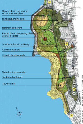
Jaffa Slope Park general plan, courtesy of Braudo-Maoz Landscape Architecture Ltd. (labels added by the author).

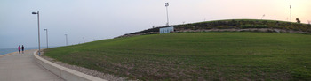
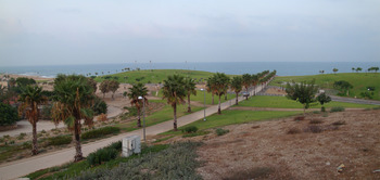
Jaffa Slope Park: a hill and seaside promenade, September 5, 2011.Footnote 2

But Jaffa Slope Park has a substantial local milieu that transcends the environmental realm. The grind waste that became this lawny park's raw materials—earth, gravel, and planting soil—contains the ruins of hundreds of pre-1948 Jaffan Palestinian homes and buildings.Footnote 4 As such, the park's materiality and the site's perception delineate urban contexts of national conflict, spatial institutional ruination, housing insecurity, civilian experience of loss, and civilian resistance.Footnote 5 Raymond Williams's strategy of relating the history of the landscape to “the common history of a land and its society” is thus helpful in contextualizing the neighborhood and the site.Footnote 6
The focus on the strata of landscape architecture enables us to analyze a multifaceted professional terrain that generates varying spatial activities and experiences.Footnote 7 Landscape architecture scholar James Corner wrote that “because of its bigness—in both scale and scope—landscape serves as a metaphor for inclusive multiplicity and pluralism … [Landscape architecture] may still embrace naturalistic and phenomenological experience but its full efficacy is extended to that of a synthetic and strategic art form.”Footnote 8 In other research fields landscapes are analyzed as physical and imaginary ideological apparatuses.Footnote 9 Geographers Denis Cosgrove and Stephen Daniels argued that a park is “more palpable but no more real, nor less imaginary, than a landscape painting or poem.”Footnote 10 Thus the physical landscape architecture of Jaffa Slope Park reveals its landscape as a medium of signification that not only produces ideology, but may undermine it as well.Footnote 11
In 1991, Landscape Journal published a collection of short conference papers featuring a preliminary theoretical discussion about undermining “critical landscape architecture.”Footnote 12 Since then, there have been no case studies methodologically and theoretically elaborating on the issue. Jaffa Slope Park helps illustrate the figural formation of dominant ideological landscape architecture in Israeli cities, and underscores three novel critical landscape architecture significations—ethical, political, and allegorical—that challenge this dominant figural formation.
The breaching utterances found at the park undermine prevalent imagined and concrete semiotics of landscape, especially in the way they interrupt the coherence and spatial order of two key landscape emblems of Jewish-Arab shared urbanities that are routinely laid vertically: (1) the repressed pre-1948 Palestinian urbanity and the remains of ruined Palestinian structures and landscapes;Footnote 13 and (2) the repressive Israeli landscape mold of a green layer that veils both the ruins and the state's acts of ruination.Footnote 14 The first landscape emblem of urban ruination emerges from the history of the park's site and materiality, from the park's design, and from residents’ requests uttered and documented during public participation meetings concerning the park's design.Footnote 15 The second landscape emblem, the repressing greening mold in urban environs, is further theorized on the grounds of the design of Jaffa Slope Park and other major public parks in Tel Aviv–Jaffa, and based on the residents’ discourse during the public input meetings. These ethical, political, and allegorical landscape utterances destabilize yet another two dichotomous landscape syntaxes that were evident in the public meetings’ discourse: one attributed to typical lawny urban park landscapes created by Jews, the other to agricultural Arab landscapes.Footnote 16
Research addressing spatial representations of pre-1948 Palestinian urbanity and the urban Nakba is grounded in the concept of memory.Footnote 17 But one can also view design discourse and spatial representations through the lens of Emmanuel Levinas's theory of the ethical face-to-face encounter between the I and the Other and the utterance of this ethical experience.Footnote 18 Levinas's theory describes the necessity for reflexive interruptions to traditional and logical modes of signification in order to ethically represent the Other and the ethical event of encounter.Footnote 19 Several interviews with Alisa Braudo,Footnote 20 the park's leading landscape architect, disclose lingual traces of ethical experience that may have occurred during the public participation meetings. Additionally, the haunting, interrupted design of some park elements reflects moral debt to the local aftermaths of the Nakba and to PalestinianFootnote 21 residents’ loss, which were articulated in the course of the public meetings.
The landscape architecture of the park is interpreted and theorized based on this historic, emblematic, and discursive contextualization, drawing from both park experience and photographic documentation.Footnote 22 The park's landscape is discussed as a medium of signification immersed in dominant ideology, which produces it, but moreover, breaches it with exceptional, first-of-their-kind landscape architecture utterances.Footnote 23
Ruination, Ruins, Loss
The 1948 war—the Palestinian NakbaFootnote 24 and the Israeli War of Independence—are key historical events that shaped the park's materiality and its design conceptualization. The besieged, bombarded city of Jaffa surrendered in April 1948. About 4,000 Arab residents remained following the war, a small fraction of the 73,000 who lived in this booming Palestinian city prior to the conflict. Those who left their homes during the protracted battles were not allowed to return, prohibited by the new Israeli state's legislation.Footnote 25
Depopulated, Jaffa and its confiscated homes were immediately occupied by thousands of Jewish immigrants and Holocaust survivors.Footnote 26 Israeli authorities architecturally distorted and dissected Palestinian homes in order to multiply the number of residential units, which were in great demand.Footnote 27 Arabs and Jews intimately shared divided apartments in the jammed city.Footnote 28 They were all protected tenants in the depopulated Palestinian properties that the state appropriated and leased.Footnote 29
The first Israeli urban master plans for west Jaffa compiled in the 1950s and 1960s called for an almost total demolition of the existing Palestinian built environs, which were to be replaced with modern housing projects.Footnote 30 This widespread scheme of urban planning during the state's first three decades led to a massive physical destruction and exclusion of Palestinian residents,Footnote 31 a spatial process that was termed by Ziva Kolodney and Rachel Kallus (referring to the similar case of Haifa) “erascape … a mechanism based on erasing an existing landscape to make way for another …a powerful method of creating new spatial order by uprooting and displacing.”Footnote 32
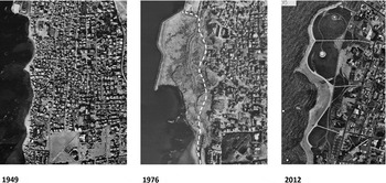
During the 1970s and 1980s Jewish residents gradually moved out of Jaffa's western neighborhoods to new neighboring housing projects.Footnote 33 This exodus resulted in a massive destruction of hundreds of buildings in the neighborhood, in accordance with the urban master plans. But the protected Arab residents remained and continued to live in this perforated urban setting, underserved by the municipality for another three decades.Footnote 34 Jaffa's ruins were piled on the city's shore together with additional construction waste from the entire Tel Aviv area, gradually creating a fifteen-meter-high construction-waste mound that steadily expanded deep into the Mediterranean (fig. 4). In 1981, a new city general plan unveiled the municipality's vision to allocate the reclaimed land for public open areas and lucrative land uses, such as hotels and recreation.Footnote 35
Over these decades, the remaining Palestinian families grew, and since the construction of the planned new housing projects in western Jaffa was delayed and the Israeli urban master plan restricted any extension to existing buildings, their homes were expanded without legal permits. Many of these extensions constructed without permits were subsequently destroyed, adding an additional layer of construction waste to the waste mound and a broadening sense of ruin to the Palestinian residents’ life experience.Footnote 36
In the 1980s, in response to the growing popularity of the “Arab house” in the Jewish-Israeli housing culture,Footnote 37 the municipality began to prepare a new urban master plan that preserved Palestinian buildings and urban textures in west Jaffa.Footnote 38 The new plan added new building rights to many of the existing buildings.Footnote 39 The additional rights and intensive public development of infrastructure attracted new private investments to the neighborhood in the 1990s, and still do today. But as Palestinian residents suspected already in 1988,Footnote 40 the plan did not protect poor renters from spatial exclusion in a prolonged process of gentrification.Footnote 41 Jaffa Slope Park cannot be separated from this policy in west Jaffa. The park is a public amenity that improves the quality of life and hence boosts property values and the displacement of Palestinian old-timers from their locale.Footnote 42
This synopsis of the recent urban history of Jaffa, with its home splitting, “erascape,” and exclusion, affirms the asymmetrical ethnic power relations by which the state and municipal institutions profoundly shaped ethnically mixed urban spaces by planning. However, in an alternative analysis of the production of space in Jaffa, Daniel Monterescu maintains that Jaffa forms “political and cultural arenas that defy the binary logic of ethnonationalism and urban colonialism.”Footnote 43 He describes an urban “relational spatiality” created by forces of capital, state, and municipality and by quotidian cultural transactions between stranger identities, which produces cultural indeterminacy and separates (mandatorily and voluntarily) between spaces and identities.Footnote 44
Such relational spatiality can be traced in two civilian campaigns that have had an impact on the park's site. The first, a joint campaign by Jewish gentrifiers and Arab old-timers, resulted in ending land reclamation and waste disposal in 1988. The second multi-identity fight focused on residents’ inclusion in Jaffa Slope Park's planning, which resulted in public meetings in which visions for the park represented both separate and entwined ethnic landscape sign systems.
Design Discourse: Landscape Sign-Systems and Presence of the Other Who Utters Loss
The public meetings about the park's design were organized by municipal officials with the participation of landscape architects. The deliberations were conducted in Jaffa in 2004 and 2005 among nine ethnically and geographically divided groups.Footnote 45 During the meetings, members of three different groups—Kedem Street Residents Group, the Arab Christian Orthodox Scouts Cadets Group, and the Muslim Women's Group—presented their wishes for “lawn,” “lots of trees and lawn,” and “a park like the Jews’ parks.”Footnote 46 These requests testify to the power of imagery imprinted on some Palestinian residents of Jewish-Israeli parks, with lawns—as Kenneth Helphand has shown—at the “core of most of Israel's city parks.”Footnote 47
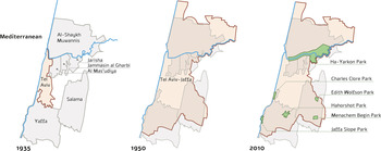
The lawn, and especially the lawny hill, is a key signifier of Israeli urban parks, and a predominant mark of urban parks globally.Footnote 48 Landscape scholars have critiqued the worldwide usage of this supposed natural scheme for its flattening of local landscape dialectsFootnote 49 and for its masking of the harmful exchanges between civilizations and their environments with pastoral scenes.Footnote 50 Lawns were first introduced into the landscapes of Palestine during the 1930s at kibbutzim and private urban villas.Footnote 51 It was one layer among the evolving multilayered greening scheme of the Zionist movement,Footnote 52 which involved afforestation,Footnote 53 gardening, and agricultural cultivation.Footnote 54 Studies in the environmental history of Israel/Palestine propose that these environmental schemes were intertwined with the Zionist territorial ambitions to possess lands in Palestine and colonize them,Footnote 55 and that these schemes were at times achieved at the cost of Arab fellahins’ means of support.Footnote 56 In prestate years the forest landform scenically denoted and legally preserved Jewish land ownership;Footnote 57 the forest became a national icon, symbolizing the striking of roots in the ancient homelandFootnote 58 and the national redemption of an allegedly deteriorated land.Footnote 59 After the establishment of the State of Israel afforestation also served to conceal the ruins of many of the depopulated Palestinian villages.Footnote 60 Greening, too, became a veil hiding Palestinian pasts in urban locales; the city of Tel Aviv–Jaffa tripled its open public spaces between 1948 and 1953,Footnote 61 due to the annexation of much of the land of pre-1948 Jaffa and the surrounding villages.Footnote 62 The city's first public parks were established on these lands (fig. 3), and the parks’ designs adopted lawns and the naturalizing schemes of the English garden style.
1935: The municipal borders of Tel Aviv and its neighbouring Arab municipalities;Footnote 63 1950: Tel Aviv–Jaffa municipal borders after the annexation of the Palestinian municipalities; 2010 (the date of Jaffa Slope Park's inauguration): The city's urban parks are located on former Palestinian locales. Maps’ superposition by the author.

Ha-Yarkon Park was established in 1952 on the lands of the village of Al-Shaykh Muwannis.Footnote 64 Inaugurated in 1974, this 3.5-square-kilometer lawny park also covers the lands of Jarisha, Al-Jammasin al-Gharbi, and Masʻudiya (fig. 3).Footnote 65 The moderate verdant hills of Charles Clore Park, a seaside park that has connected Jaffa and Tel Aviv since 1974, hides the ruined Jaffan neighborhood of Manshiyye. Likewise, beneath the swards of Edith Wolfson Park (1976) and Menachem Begin Park (1988) in the southeastern parts of the city are lands that were once owned and cultivated by the people of Salama village (fig. 3). The state's ideological foundations of territorial Jewish domination and supremacyFootnote 66 were spatially achieved in the Tel Aviv–Jaffa not only through warfare, but also through the transformative greening designs of everyday landscapes in parks.Footnote 67 Greening in large open spaces of Tel Aviv–Jaffa fabricated a new landscape, where rolling lawns and sinuous paths conceal and naturalize the state's acts of depopulation, appropriation, and ruination.
This interpretation of landscape semiotics was not relevant or important to those Palestinian residents who yearned for lawns that are a hallmark of Jewish neighborhood parks. In the cultural indeterminacy of Jaffa, which constantly separates between spaces and identities,Footnote 68 both a cultural absorption and a demand for an equitable distribution of a standard park amenity are sensible. But some residents who participated in the meetings voiced their urge to differentiate from the traditional sign system of greening. In the meeting with the Arab Leadership Group, there were requests for “as much orchard [pardes] as possible and as little lawn as possible” and a “grove of olives, grapes, palms.”Footnote 69 In the meeting with the Arab Scouts Cadets Group “oranges, roses, and guavas” were favored.Footnote 70 These species are not common in the design of large Israeli urban parks.Footnote 71 The “orchard” reverberates with the famed orange groves that surrounded Jaffa prior to its fall in 1948;Footnote 72 the other fruit-bearing species denote the core icons that dominated Palestinian literary and visual representations of landscape over the course of the two decades after 1948.Footnote 73
The two ideological landscape sign systems, one of pastoral lawns and one of local fruit trees, were expressed in the discourse of meetings. At times they were hyperbolized and contrasted to each other; at others their borders were unraveled. Both sign systems were entwined in the park's design in critical breaching landscape architecture expressions.
No less important are two other measurements of the design discourse: the affective and the ethical experiences. According to the municipality's documentation of the meetings a long-time resident, a Jewish gentrifier, requested “a symbol for the Nakba.”Footnote 74 The landscape architect Aliza Braudo recalled during an interview that over the course of a meeting with the Arab Leadership Group, a resident expressed the wish “to leave it all as a symbol of the Nakba.”Footnote 75 The Palestinian catastrophe is certainly not a source for elaborated landscape meaning in urban public spaces, and the presence of the term “Nakba” during discussions over design is not routine; in fact, the mere mention of the term constitutes a threat in some Jewish parts of Israeli society.Footnote 76
But the phrase “to leave it all [the waste mound] as a symbol for the Nakba” stands out also because there were no other residents with a similar vision for the site. The exceptional request may suggest that the historical, or even continuing, Palestinian trauma stems from the site and demands recognition. The phrase insinuates that an architectural representation of a landscape “as a symbol” of the city's destruction, and the Palestinian experience of loss, “the Nakba,” are more crucial than the site's environmental recovery and the supply of common park amenities to the neighborhood. Haunted by this demanding, enigmatic phrase, Braudo grappled with its denotations in our first meeting and revisited it during the second one, trying to determine whether the phrase expressed a real need or was voiced to express defiance.Footnote 77 The face-to-face encounter during the public meetings reverberated in the architect's troubled discourse, and became a haunting ethical experience for her, in which she became an addressee of the utterances of loss articulated by Palestinian Jaffans. This source of sensitivity may have later permeated the park's design.
Emmanuel Levinas argues that in a face-to-face encounter with the Other, the I undergoes an ethical experience and turns into a hostage of infinite responsibility for the Other: “[w]e name this calling into question of my spontaneity by the presence of the Other ethics.”Footnote 78 In the face of the Other the I is split, experiencing inner heteronomy or a sense of the Other within the same.Footnote 79 The Other, in Levinas's words, exceeds essence: “the metaphysical other” is not the idea of the Other; “is not the simple reverse of identity, and is not formed out of resistance to the same, but is prior to every initiative, to all imperialism of the same.”Footnote 80 Levinas struggled with the question of how to represent the Other and the ethical situation, because language and philosophy eventually essentialize the Other, and therefore betray him.Footnote 81 He proposed a split apparatus of signification in which the “saying” is not congruent with the essence in the “said”; “saying” is a haunted, reflexive signification that interrupts the “said,” forms “an exception” in essence, and resonates with the haunting ethical experience and the unavoidable betrayal.Footnote 82 Reading Levinas, Simon Critchley described this mode of utterance “interruption of interruption,” interruptions that are serially inserted into thematic conceptualization and into textual syntax and rhythms.Footnote 83 Levinas's theory helps us see that the discursive acknowledgement of the collective Jaffan Nakba, and the haunting experience of facing the resident who utters loss during the planning meeting, reverberate in the park's design in interrupting landscape architecture utterances.
Breaching Landscape Architecture
The structure of Jaffa Slope Park is rather clear (fig. 1). Three expansive rolling hills took the place of the flat-top waste mound and now make up the park's major features (figs. 4, 5). As the hills constantly hide parts of each other, they create a deceptive visual conception of the park's dimensions; a stratagem widely used in eighteenth-century English garden style and nineteenth-century Victorian public parks.Footnote 84 There are two layers of meaning in this design mold. On the one hand, the grassy hills directly invoke global park conventions, but on the local level, they are also in accord with the dominant greening sign system that obscures the pre-1948 Palestinian spaces and traces of their destruction within mixed cities like Tel Aviv–Jaffa.
As an art form—a poetic, or rather, poietic practice—that contains the pragmatic dimensions of activating open public spaces and urban natures,Footnote 85 landscape architecture can potentially access what Louis Althusser defined as art's capacity to differ from ideology by means of an “inner distance”: “What art makes us see, and therefore gives to us in the form of ‘seeing’, ‘perceiving’ and ‘feeling’ (which is not the form of knowing), is the ideology from which it is born, in which it bathes, from which it detaches itself as art, and to which it alludes.”Footnote 86
Jaffa's shoreline and urban texture in 1949; after institutional ruination and land reclamation in 1976; after the park's construction in 2012. Aerial photographs: Jaffa, 1949: P/53-7368 and 1976: MM/503-2731, Survey of Israel, Agency for Geodesy, Cadastre, Mapping and Geographic Information. All rights reserved by the Survey of Israel ©2016. Printed with Survey of Israel permission.  Jaffa, 2012: ©Google, ©2012 GeoEye.

Jaffa Slope Park: a palm boulevard cuts between the hills, September 5, 2011.

The ideology immersed and recreated in the lion's share of the park's design is transgressed in the landscape architecture of the historic shoreline path, which runs along the park's margins, east of the hills and main cycling artery (fig. 3).Footnote 87 According to Braudo the path stretches along Ajami's historic waterline that was gradually covered with waste from the 1970s onwards: “The historic shoreline path is almost congruent to the original water line, along which we will post debris from the site, like statues. I think we should not hide what had been there; there was a neighborhood, and there was waste. All layers should be presented. … It is right that the past will return in a tacit manner.”Footnote 88
The realistic gesture of the path assumes that similitude to a historical-geographic fact can lead to a sense of “what had been there,” the true history of the site. But the path seems to refer only to the lost geography, rather than to the active institutional destruction that caused that geographical absence and its aftermaths. Yet, the realistically drawn path escapes literality in an unexpected manner. The overlap between the path and the historic shoreline exists only in its two-dimensional representations, such as architectural drawings or aerial photography; the existing topography of the foot of Jaffa's ridge differs significantly from the original one, for the former slopes and shoreline are still buried under the waste and tons of ground debris produced during the recycling process. The new slopes are shaped as soft curvilinear spurs. Thus the path climbs and descends on top of the new slopes that raise its height far above sea level. As a result the path is uncomfortable for walking, and it does not have any particular destination or landmarks along the way. These deficiencies render it ineffective as a path for strolling, exercise, or for observation.
Paths are generally obvious to the bodies that walk through them, enabling users to move about efficiently and contemplate other things rather than the act of walking or the path's existence. This landscape expression gains a degree of obscurity that subverts the sense of predictability of paths, which characterizes most traditional schemes of urban parks, and also the rest of Jaffa Slope Park's paths. The inconvenience that the path causes is a break in the landscape architectural convention of accessibility, and a figural disturbance to the park's aesthetic sequence. These breaks heighten the consciousness of acts of landscape planning and design, as well as of performative acts such as walking, keeping balance, and seeing within constructed landscapes.
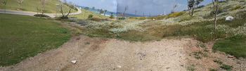
Reflexivity is the outcome of this consciousness. It is amplified when the path is abruptly blocked at its northern portion by a low barrier of perennial ruderal species (fig. 6).Footnote 89 The park's plan shows that the path descends down the Al-Ajami Mosque's slope until it joins together with the park's main cycling route (fig. 1). Yet when gardeners sowed this part of the slope with perennial species, they did not spare the path's route. The seedlings thus grew also on the path, creating a floral barrier. This enigmatic obstacle to the flow of pedestrians signals reflexively that someone has the competence to lay out a route—or to block it.
Jaffa Slope Park: the ruderal plants form a barrier on the historic shoreline path, April 11, 2012.

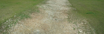
Such introspection is amplified when the path runs through lawn surfaces, and offshoots of grass threaten to gradually cover the path (fig. 7). The city's gardeners perpetually spray and trim the rhizomes in order to halt this vegetal ambition, thereby recreating the path over and over again. This constant remaking of the path embodies the work needed to achieve a landscape template. The repeated interruptions to the path's existence by the lawn's rooting and the subsequent interruptions to the grass's expansion by its uprooting echo Levinas's concept of the reflexive utterance, which repeatedly interrupts essence after the ethical experienceFootnote 90 —an utterance that contains inner instability between traditional systems of signification and a series of interruptions to these systems. Thus an inner difference is inserted into the supposedly solid concept and experience of “a path” via the serial interruptions that question its convention. The path becomes landscape architecture that questions landscape architecture, turning a landscape scheme into “meta-landscape architecture.”Footnote 91 Jaffa Slope Park becomes that sort of meta-landscape architecture as the path restrains and troubles the traditional naturalizing greening template that typifies much of the park's grounds.
Jaffa Slope Park: lawn covering the historic shoreline path, April 11, 2012.

Yet the path's landscape architecture is not only a figural disturbance. The historic shoreline path is also a political expression. As Simon Critchley argues, politics, “cannot be confined to the activity of government that maintains order, pacification and security while constantly aiming to consensus. On the contrary, politics is the manifestation of dissensus, the cultivation of an anarchic multiplicity that calls into question the authority and legitimacy of the state.”Footnote 92 Critchley further contends that when a Levinasian ethical experience occurs in a context of institutional oppression, it may ignite a political action or an aesthetic, sublimating political expression.Footnote 93 The strange phrase “to leave it all as a symbol for the Nakba” denotes both an ethical situation of sharing a trauma of loss during a public meeting, and a political act that undermines institutional spatial policies and connects their outcomes to a continuous national trauma.
James Corner argued that landscape architecture may devise a critical, political response by working “within the norms and codes of a particular practice” through creating reflective distance from repressive or erroneous prevalent landscape traditions.Footnote 94 The political cultural act ought to be historically contextualized, but to undermine historical narratives;Footnote 95 to problematize the moral legitimacy of institutional power,Footnote 96 but to be temporal.Footnote 97 Respectively, the same text, or landscape architecture utterance, can be read as either a political or an ideological utterance.Footnote 98 The historic shoreline path can be read as a political landscape utterance in the context of the traumatic historical narrative of the site and the park's timely affective discourse, but also within the context of Jaffa's cultural indeterminacy, which was reflected in the public meetings’ discourse.
The material used for the path is the actual crushed debris from the waste mound that contained the wreckage of destroyed Palestinian buildings and homes. It embodies Jaffa's historical trauma of institutional destruction, which reverberates in the resident's and the architect's phrasing: “to leave it all as a symbol for the Nakba.” On the ground, the grass's offshoots constantly pervading the path's surface (fig. 7) abide by the ideological logic of hiding Palestinian remains under a green concealer (fig. 3). Along the path the work of the gardeners, who act as the municipality's proxies, is to actively prevent the routine pattern of covering the ruined Palestinian environs with lawns. Temporarily, they expose the ruins’ disturbing presence, a trace of coercive power and experience of loss; time and again, the trimming questions the dominant Israeli park mold in Tel Aviv–Jaffa and produces a temporal inner distance inside this mold. This rare instability within a traditional Israeli landscape sign system is further intensified in an additional landscape architecture formation—the allegorical utterance—at the northern portion of the path.
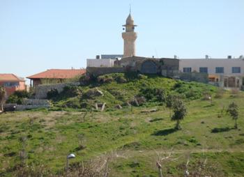
As the historic shoreline path stops by the floral wall at its northern edge, it encounters an additional troubling landscape expression, contributing another layer of estrangement to the park's scheme. The newly designed steep slope under the Al-Ajami Mosque, sowed with the ruderal species, was planted in grid order with pomegranate, mulberry, and fig trees (fig. 8). This planting design seems to address the requests that were presented in the public hearings by Palestinian residents of Jaffa to use fruit trees that denote a recognized Palestinian landscape signification. Nevertheless, this landscape syntax becomes self-estranged, just like the lawn's territorial ambition that was constrained and problematized in the path. Some of the trees on the slope did not take root, but were left to stand on the ridge, fossilized relics of vitality (fig. 8). This intimacy between life and death in the same milieu alludes to Walter Benjamin's conceptualization of allegory: “[T]he allegorical physiognomy of nature-history … is present … in the form of the ruin … and in this guise history does not assume the form of the process of an eternal life so much as that of irresistible decay. Allegory thereby declares itself to be beyond beauty. Allegories are, in the realm of thoughts, what ruins are in the realm of things. … That which lies here in ruins, the highly significant fragment, the remnant … pile up fragments ceaselessly, without any strict idea of a goal.”Footnote 99
The dead trees on the slope of the park in Jaffa are botanical ruins—emblems of allegory. Their presence among living fruit trees thwarts the performance of the fertile orchard, the Palestinian symbol. The allegorical utterance of the dead trees prevents a symbolic mode of memorialization, thereby yielding a rather unspecific sense of decay and loss.
Jaffa Slope Park: half-dead orchard and wreckage under Al-Ajami Mosque, February 21, 2012.

Next to the vegetal ruins, some concrete pillars and spurs are laid, disengaged, right under the mosque on the slope (fig. 8). It is unknown whether these ruins were part of a former wall around the mosque or belonged to an entirely different building.Footnote 100 Nevertheless, the minaret, a key spatial symbol of Muslim identity, is destabilized in this allegorical landscape scene by the ruins lying at its foot. The cryptic view of the solid and the ruined—vegetal and architectural—signifies an unclear historicity of decay, generating a melancholic scenic experience that adds additional disturbance and fragmentation to the park's naturalizing greening mold.
The reflexive ethical, political, and allegorical landscape utterances fracture the park's overriding Israeli/Zionist landscape template. However effective they are, the green veiling formation in the park is undeniably dominant because of the massive presence of the grassy hills. This dynamism, straddling between a dominant ideological cultural form and the breaching utterances that challenge it, reinforces the notion that hegemonic cultural production is a “heterogenic, dynamic system that moves towards … [their] stabilization through the constant contestation of political-figural interruptions.”Footnote 101
Coda
Discourse analysis of Jaffa Slope Park demonstrates that the Zionist Israeli greening practices prevalent in Tel Aviv–Jaffa's public parks on sites of pre-1948 Palestinian milieus are identified as such by local residents. For some residents, Jews and Arabs, contested urban policies and traumatic experiences are significant and deserve expression in the landscape design of public spaces. The discursive interaction between residents and landscape architects enables the emotive communication of urban loss, which allows for ethical experience that may yield breaching critical landscape architecture.
In this constructed landscape architecture the Al-Ajami Mosque slope and the historic shoreline path become a figural and performative sequence of interruptions to the landscape architecture of a major seaside park in the city of Tel Aviv–Jaffa. The fragmented address of Palestinian loss and the reflexive representations of a repressive ideological landscape mold evolve into groundbreaking spatial expressions within Israeli Jewish-Arab shared urbanity. Thus, landscape architecture has the means to critically signify and subtly communicate an ethical experience and contextually politicized meanings of landscapes. This capacity of landscape architecture bears import for ethnically divided urbanities that endured historic processes of dispossession, ruination, and prolonged dereliction.
Today, the half-dead orchard, the dropped concrete beams, the flowering barrier, and part of the historic shoreline path on the mosque's slope have been replaced with an additional wing to the adjacent Hassan Arafe Arab public elementary school. The breaching landscape expressions in the park were significantly diminished but they haven't entirely disappeared.