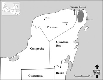
The Yalahau region, located in the Mexican state of Quintana Roo, represents a unique physiographic landscape. Framed to the north by the Holbox Lagoon, the region is dominated by extensive freshwater wetlands and stands in sharp contrast to the dry karstic plain that characterizes the majority of the northern Yucatan Peninsula (Figure 1). Dunning and colleagues (Reference Dunning, Beach, Farrell and Luzzadder-Beach1998:91) include the Yalahau region as one of the 27 different “adaptive regions” in the Maya Lowlands that “presented Maya peoples with a landscape of varied agricultural opportunities and constraints.” The wetland/upland topography and climatological patterns of the Yalahau region have combined to create a dry tropical forest that is one of the most biotically rich and diverse ecosystems in the northern Maya Lowlands (Schultz Reference Schultz, Gómez-Pompa, Allen, Fedick and Jiménez-Osornio2003). It is this unique landscape that presented itself as an area of study.
Location of the Yalahau region in northern lowlands.

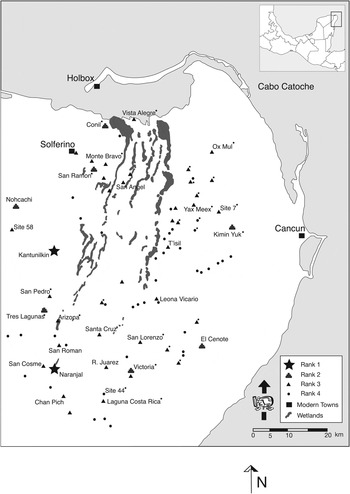
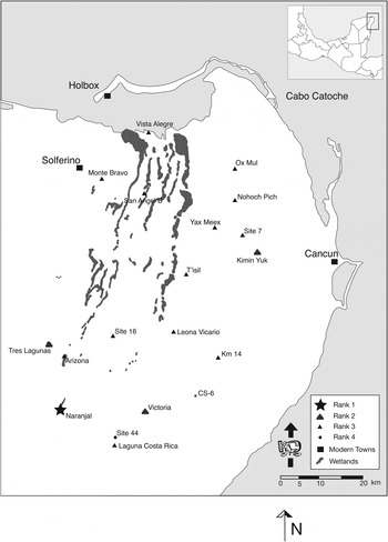
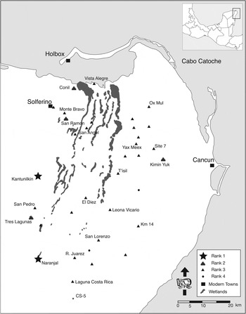
The Yalahau Regional Settlement Pattern Survey (YRSPS) was conducted to position the other work of the Yalahau Regional Human Ecology Project (YRHEP) in its broader regional context (Glover Reference Glover2006). At the inception of the project, 40 sites had been documented across the region beginning with Alberto Escalona Ramos' work in 1937 (Escalona Ramos Reference Escalona Ramos1946). At the conclusion of the YRSPS, 54 undocumented sites were recorded between 2001 and 2005 (Figure 2). These sites range in date from the Middle Preclassic period (ca. 700 b.c.) to the Postclassic and Contact periods. As will be discussed below, the vast majority of the settlement dates to the Terminal Preclassic period (75 b.c./a.d. 100––a.d. 400) followed by a major depopulation of the area that arguably lasted until the Postclassic period (ca. a.d. 1100). While providing a cultural-historical overview of the region, this article focuses its attention on the dynamic sociopolitical landscape of the Terminal Preclassic period.
Sites located to date in the Yalahau region including their ranking in the regional settlement hierarchy. The * indicates sites where ceramics were collected. Excavations were conducted at Arizona, Kimin Yuk, Monte Bravo, Ox Mul, Site 7, Tres Lagunas, Victoria, and Yax Meex.

The YRSPS differs from the majority of regional settlement pattern studies in the Maya Lowlands because of its scale, the occupational history of the region, and its theoretical orientation. Most regional projects in the lowlands have been situated around a major center and were designed to explore its “hinterlands” and secondary centers (Fedick Reference Fedick1988; Murtha Reference Murtha2002; Puleston Reference Puleston and Hammond1972; Tourtellot Reference Tourtellot1988; Yaeger Reference Yaeger, Canuto and Yaeger2000). Others have conducted transects between major centers (Ford Reference Ford1986; Garrison Reference Garrison2007; Smith Reference Smith2000). All of these have been valuable, but in comparison, this work was less systematic due to the 5,118 km2 being investigated.
The Yalahau region offers a strikingly different view of ancient Maya sociopolitical relations than is normally provided by settlement pattern projects. Over the vast majority of the Maya Lowlands, surface settlement dates to the Late or Terminal Classic period. The Yalahau region, however, appears to have none of the Late or Terminal Classic “overburden” and provides an unfettered view of the Terminal Preclassic political landscape, a situation both exciting and challenging. The challenge comes from the fact that the large body of data on ancient Maya sociopolitical organization corresponds to the Late and Terminal Classic periods and is not directly applicable to the Yalahau data.
At the same time, the most valuable aspect of the Yalahau regional data is that they contribute to a growing body of literature that provides insight into the Preclassic Maya at a regional scale (Andrews and Robles Castellanos Reference Andrews and Castellanos2004; Hansen Reference Hansen and Houston1998; Hansen and Guenter Reference Hansen, Guenter, Fields and Reents-Budet2005; Johnston Reference Johnston2006). Investigations in the lowlands focusing on the Preclassic have been on the rise in the past decade (Bartlett and McAnany Reference Bartlett, McAnany, Canuto and Yaeger2000; Estrada Belli et al. Reference Estrada Belli, Grube, Wolf, Gardella, Guerra-Librer and Archila2003; Fields and Reents-Budet Reference Fields and Reents-Budet2005; Gallareta Negrón Reference Gallareta Negrón2005; Garrison Reference Garrison, Laporte, Arroyo and Mejía2005a, Reference Garrisonb; Ringle Reference Ringle, Grove and Joyce1999; Rissolo et al. Reference Rissolo, Rodríguez, Ball, Shaw and Mathews2005; Saturno Reference Saturno, Laporte, Arroyo, Escobedo and Mejía2003; Stanton and Ardren Reference Stanton and Ardren2005; Taube et al. Reference Taube, Saturno, Stuart, Laporte, Arroyo, Escobedo and Mejía2004; Urquizú Sánchez and Saturno Reference Urquizú Sánchez, Saturno, Laporte, Arroyo, Escobedo and Mejía2004). The majority of Preclassic projects, however, have tended to focus on specific buildings, generally discovered by penetrating excavations below Late Classic constructions or on specific sites; the major exceptions are the Mirador Basin project (Hansen Reference Hansen and Houston1998) and the Costa Maya project (Andrews and Robles Castellanos Reference Andrews and Castellanos2004). By providing a regional perspective to Preclassic sociopolitical organizational strategies, the Yalahau research provides a comparative dataset not just for Maya scholars, but also for Mesoamericanists interested in Late Formative social formations.
For the past 30 years a neoevolutionary structural paradigm has informed Mesoamerican archaeology. This theoretical perspective views societies as coherent wholes and attempts to place them in typological categories that obscure the complexity of sociopolitical relations. Through the employment of a practice-based, post-structural approach, this research is a marked shift in the orientation of archaeological investigations and strives to better contextualize the complex social negotiations that constituted past societies.
Given the spatial nature of regional settlement data, this research focused on the active role played by the built environment in the ever-emergent processes that constitute society; a topic of interest to scholars across the globe (Janusek Reference Janusek2004; A. Smith Reference Smith2003; M. Smith Reference Smith2003; Varien and Potter Reference Varien and Potter2008). To this end, a relational approach was employed that stresses a dialectical relationship between social practices and the built environment (Giddens Reference Giddens1984; Lefebvre Reference Lefebvre1991; Pred Reference Pred1990). Specifically, by employing this approach I can better conceptualize the messy social negotiations that constituted Terminal Preclassic period sociopolitical relations. Most intriguing was the community-specific nature of the monumental constructions within the region. Monumental architecture materializes an enduring sense of community identity. This shared sense of identity was engendered both through the construction process, generally perceived as a communal activity, as well as the subsequent rituals conducted in and around the structures (see Hendon [2010] and Hutson [2010] for recent discussions on the active role played by the built environment in subject formation). These rituals focused on creating a master narrative for the community, possibly associated with a patron deity or a venerated ancestor, and as will be argued below, the style and layout of the structures were important aspects in the creation and maintenance of this communal identity.
While not denying that monumental architecture was a locus for political conflict, often in the form of factionalism, the data from the Yalahau region and from the Maya Preclassic period in general point toward the presence of a more egalitarian ethos (Chase and Chase Reference Chase, Chase and Grube1995; Freidel and Schele Reference Freidel and Schele1988). This egalitarian ethos, however, was contrasted with the reality of emerging social inequalities. By examining the tensions between the egalitarian ideal and expression of these inequalities, archaeologists can better understand the social negotiations that constituted the society in question. This research was not conducted at a scale that allowed for the investigation of changing burial practices or other artifact-based correlates that could be revealing of these social tensions within and between communities (Barber and Joyce Reference Barber, Joyce, Wells and Davis-Salazar2007; Bartlett and McAnany Reference Bartlett, McAnany, Canuto and Yaeger2000). Even without these data, a study of the built environment provides insight into these tensions.
PREVIOUS RESEARCH IN THE YALAHAU REGION
Following Ramos, William T. Sanders conducted two field seasons in northern Quintana Roo in 1954 and 1955 (Sanders Reference Sanders1955, Reference Sanders1960). His main goal was to create a ceramic sequence, and to this end, he conducted a test-pitting program at sites across the area. While his focus was intensive excavations and settlement pattern research at Tancah and Tulum, he worked at nine sites in the Yalahau region, seven of which were undocumented (Sanders Reference Sanders1960). The legacy of this work cannot be overestimated, and it provides us with an important record of the regional ceramic chronology.
After Sanders' pioneering research in the region, no fieldwork was conducted in the region until the 1980s. The Yucatan Archaeological Atlas project identified one site on the western edge of the region, Nohcachi (Garza Tarazona and Kurjack Reference Garza Tarazona and Kurjack1980; Góngora Salas Reference Góngora Salas2000). In the late 1980s, Karl Taube and Tomás Gallareta Negrón conducted work at the site of San Angel (Gallareta Negrón and Taube Reference Gallareta Negrón, Taube, Shaw and Mathews2005; Lombardo de Ruiz Reference Lombardo de Ruiz1987; Taube and Gallareta Negrón Reference Taube and Negrón1989). They mapped the larger mounds at San Angel, collected ceramic material, and recorded the site's intact Postclassic mural paintings. A few years after this project there was an Instituto Nacional de Antropología e Historia (INAH) rescate (rescue) project conducted during the construction of the supercarretera (toll highway) between Mérida and Cancún in 1992 and 1993. The project documented 13 sites in Quintana Roo, 11 of which were in the Yalahau region. All of the sites aside from Leona Vicario (where the only intensive research was conducted) were undocumented and were clusters of small, residential mounds (Pantoja Díaz Reference Pantoja Díaz1997:179–183).
In 1993, Taube and Scott L. Fedick initiated the Yalahau Regional Human Ecology Project (YRHEP) (Fedick and Taube Reference Fedick and Taube1995). Since its inception, the YRHEP has conducted intensive archaeological investigations in three main areas within the region. The first fieldwork involved investigations at and around the large Late Preclassic and Early Classic site of Naranjal (see below) as well as a limited regional reconnaissance (Fedick and Hovey Reference Fedick, Hovey, Fedick and Taube1995; Fedick and Mathews Reference Fedick and Mathews2001; Fedick and Taube Reference Fedick and Taube1995; Lorenzen Reference Lorenzen1999, Reference Lorenzen2004; Mathews Reference Mathews1998; Rissolo Reference Rissolo2003). Following the work at and around Naranjal, fieldwork was undertaken in and around the wetlands of El Edén Ecological Reserve beginning in 1995 (Fedick Reference Fedick and Bernick1998, Reference Fedick, Gómez-Pompa, Allen, Fedick and Jiménez-Osornio2003; Fedick and Morrison Reference Fedick and Morrison2004; Fedick et al. Reference Fedick, Morrison, Andersen, Boucher, Acosta and Mathews2000). In 1998, Jennifer Mathews joined Fedick as project codirector, and research began in earnest at the site of T'isil, a small, densely occupied Late and Terminal Preclassic community (Amador and Glover Reference Amador, Glover, Rubio and Gubler2006; Fedick Reference Fedick2000, Reference Fedick2004; Fedick and Mathews Reference Fedick, Mathews, Shaw and Mathews2005; Sorensen Reference Sorensen2010). As mentioned, the YRSPS began in 2001 to provide a better understanding of the regional context of these finer-grained analyses.
SURVEY METHODS
Although the Yalahau region represents a unique physiographic landscape, the question became how to delineate it so that it was a salient archaeological research area. Unlike a basin or valley, there are no naturally limiting features around the wetlands that clearly delineated a boundary. The full study region, as defined for the survey, therefore, had to be defined based on other criteria, and a 20 km buffer area around the dry season limits of the wetlands was applied. The 20 km distance was selected because it approximates a day's walk (Chase and Chase Reference Chase, Chase, Ruiz, Marquínez, Campillo, León, García-Gallo and Castro1998:17–18; Kepecs Reference Kepecs1999:51; Kepecs et al. Reference Kepecs, Feinman and Boucher1994). Working under the assumption that the sites situated around the wetlands could have been exploiting them as a resource, the 20 km perimeter seemed a reasonable maximum extent for a Yalahau sociopolitical territory, which totals approximately 5,118 km2 (see Figure 1).
Given the region's size, a combination of informant-based and roadside survey techniques were employed. Asking the people who are out in the forest on a daily basis hunting, collecting wood, or tending their milpa was the most efficient strategy to identify the greatest number of sites in the least amount of time, especially in a region with few roads and dense forest cover. I hired guides wherever I went so that there was always a community representative to supervise the work and minimize the potential for rumors, which can be disastrous to the relationship between the archaeologist and the local community (Rissolo and Mathews Reference Rissolo and Mathews1998, Reference Rissolo, Mathews, Mathews and Morrison2006).
The goal of the roadside survey was to supplement the data gathered from informants. This form of survey created a patchwork of surveyed blocks and corridors that offered small glimpses into the regional landscape. By employing this technique, the hope was to identify the smaller settlements that might not be easily recognized as cultural features by locals. While this did occur, the local informants led me to a surprising number of small mounds. With these two methods, I am confident that the largest sites have been identified and that a representative sample of the smaller sites now exists.
I conducted surveys at three levels of intensity. The least intensive method involved a brief reconnaissance of the site during which notes were taken on the natural and cultural features encountered. The production of architectural sketch maps with tape and compass was the next most intensive method employed. Sketch maps were made at 21 sites. The most intensive survey method involved the use of a total station to produce a detailed architectural and topographic map of the site center. At each site where a detailed map was made, I attempted to walk transects in each of the cardinal directions to generate a rough estimate of the sites spatial extent and to double-check that I had not missed any large structures. Due to time constraints, I was unable to complete four transects at each site, but an effort was always made to conduct general reconnaissance so that no major architecture went unmapped.
In addition to the survey work, ceramic data were collected through opportunistic grab samples of surface materials along with a test-pitting program. The ceramic collection and analysis were done under the direction of Fabio E. Amador (Reference Amador2005). Materials were successfully recovered at 35 locales across the region (Figure 2). Of these 35 locales with ceramic materials, seven did not have visible architecture associated with them and were classified as ceramic scatters (CS-“#”). In addition to the 35 surface collections, which resulted in 2,534 sherds, an off-structure test excavation program was implemented at eight sites (see Figure 2). The sites were judgmentally selected, as they represented some of the larger sites in the region and were distributed in the eastern, western, and southern portions of the region. In total, the 52 units placed at the eight sites yielded 9,984 sherds. Of the total 12,518 sherds, 11,425 were identified to at least the group level. Amador's (2005) analysis of the ceramic data provides the chronological framework for the interpretation of the settlement data.
CULTURE HISTORY OF THE YALAHAU REGION
From Amador's (2005) analysis of the pottery, the Yalahau region's occupational history can be organized into four major chronological periods: Middle Preclassic (700–200 b.c.), Late Preclassic/Early Classic (200 b.c.–a.d. 600), Late/Terminal Classic (a.d. 600–1100), and Postclassic (a.d. 1100–1521). This section will briefly discuss the evidence associated with each of these chronological periods before a more thorough discussion of the political landscape during the Terminal Preclassic period (75 b.c./a.d. 100–a.d. 400).
The Middle Preclassic Period (700–200 b.c.)
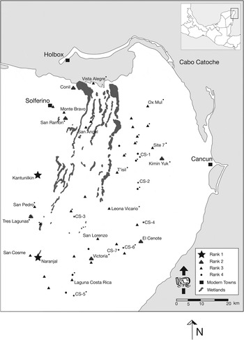
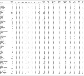
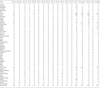
The Middle Preclassic period marks the initial archaeologically detectable occupation of the region (see Rissolo et al. Reference Rissolo, Rodríguez, Ball, Shaw and Mathews2005). The strong Terminal Preclassic material signature at all sites investigated, however, precludes my ability to discuss any specific sociopolitical machinations dating to this time period. The period is marked by the presence of one of five ceramic groups (Achiote, Chunhinta, Dzudzuquil, Joventud, or Kin) that are similar to the Early Nabanche ceramic materials from Komchen (Andrews Reference Andrews1988, Reference Andrews, Clancy and Harrison1990). These ceramic groups are present at 18 of the 35 sites where surface collections were made and at seven of the eight sites where excavations were conducted (see Figure 3 and Table 1). In total, the Middle Preclassic sherds constituted 2.97% (n = 339) of the total identified collection. While this is not a sizable sample, the ability to recover Middle Preclassic sherds from surface contexts was quite surprising given the impact of weathering factors. Of the five groups, the unslipped Achiote group was the most prevalent followed by Dzudzuquil, Chunhinta, Joventud, and lastly Kin. All five Middle Preclassic groups are also present at Leona Vicario (referred to as Santa Maria by Sanders), which was investigated by Sanders and Pantoja (Pantoja Díaz Reference Pantoja Díaz1997; Sanders Reference Sanders1960), at T'isil (Fedick Reference Fedick2005), as well in the regional cave sample analyzed by Rissolo (Reference Rissolo2003; Rissolo et al. Reference Rissolo, Rodríguez, Ball, Shaw and Mathews2005).
Sites with Late Preclassic and Early Classic materials. The * indicates sites with Middle Preclassic ceramic materials, CS-7 is the only site that just had Middle Preclassic pottery.

Ceramic groups identified in the region


Following Rissolo and colleagues (2005), the first inhabitants of the Yalahau region appear to have migrated from the northwestern portion of the peninsula, bringing with them their ceramic traditions (see Glover et al. [Reference Glover, Rissolo, Ball and Amador2011] for recent data that complicates the settlement history along the north coast). If the first peoples of the Yalahau region did indeed have their origins in the area around Komchen and Xtobo (Anderson Reference Anderson2010), it is intriguing that ballcourts, a politically and religiously significant form of architecture, are rare in the eastern side of the peninsula. These features have been identified at numerous sites of varying size in northwest Yucatan by the Costa Maya project (Anderson Reference Anderson2003, Reference Anderson2010; Andrews and Robles Castellanos Reference Andrews and Castellanos2004). A total of two possible ballcourts have been identified in the Yalahau region, one at San Ramón and the other at the nearby site of Sabana China. The unfortunate problem is that only 26 total sherds were collected at San Ramon and none at Sabana China. Even if these ballcourts did date to the Middle Preclassic period, their ubiquity in the northwest is not matched in the Yalahau region. Was this a purposeful case of forgetting by groups disenfranchised by an emerging elite? While this is certainly a topic for future investigations in the region, the establishment that there were full-time inhabitants in the region during the Middle Preclassic period is certainly an important step in our nascent understanding of the region's occupational history. The next step will be identifying architectural constructions that also date to this time period.
The Late Preclassic/Early Classic Period (a.d. 200–600)
Transitioning from the Middle Preclassic to the Late Preclassic/Early Classic period, the Yalahau region, like all of the Maya Lowlands, undergoes a dramatic increase in population along with an accompanying increase in monumental architecture (see below) and the number of ceramic groups present (Bey et al. Reference Bey, Bond, Ringle, Hanson, Houck and Lope1998:111; Stanton Reference Stanton2000:527). Of the monumental constructions, the megalithic architectural style present at some sites in the region is the most chronologically significant. While the megalithic style has attributes that overlap with the broader architectural traditions during the Preclassic and Early Classic periods, such as the platform-pyramid complex and the use of triadic groupings, it has a distinct constellation of attributes––pillow-shaped, large block masonry, apron corbels, rounded corners, and corbelled vaults (Mathews Reference Mathews1998; Mathews and Maldonado Cárdenas Reference Mathews, Cárdenas, Mathews and Morrison2006; Taube Reference Taube, Fedick and Taube1995). This architectural tradition, widespread across the northern lowlands (Hutson Reference Hutson2009; Mathews and Maldonado Cárdenas Reference Mathews, Cárdenas, Mathews and Morrison2006), is most well known from the sites of Izamal and Ake (Lincoln Reference Lincoln1980; Maldonado Reference Maldonado1990; Roys and Shook Reference Roys and Shook1966). The significance of its presence or absence at Yalahau sites will be discussed below.
The Late Preclassic/Early Classic ceramic materials, 66.88% (n = 7,641) of the total identified collection, are represented by 15 total groups and are ubiquitous (see Figure 3 and Table 1). Unlike the majority of the Maya Lowlands, however, this period represents the peak occupation in the Yalahau region. This growth, however, does not appear to be the result of immigrants flooding into the area, but the result of local developmental trajectories. This is evidenced by the limited ceramic data that we have. The local slip and paste recipes present in the Middle Preclassic Dzudzuquil group have strong ties with the subsequent Sierra and the Carolina bichrome groups (see Rissolo et al. Reference Rissolo, Rodríguez, Ball, Shaw and Mathews2005). These local ceramic developments are firmly within the Chicanel ceramic sphere but appear to be distinct from other areas of the northern lowlands given the disproportionate representation of Carolina bichrome materials (see Glover and Stanton Reference Glover and Stanton2010). The Carolina group, the most widespread group regionally, is one of the three that dominates the regional collection. Along with Carolina, the Sierra and Tancah groups comprise 85.49% (n = 6532) of the Late Preclassic/Early Classic sherds collected.
As Stanton and I (Glover and Stanton Reference Glover and Stanton2010) argue, this occupation can be further refined and most likely corresponds to the Terminal Preclassic period (75 b.c./a.d. 100–400). This argument is bolstered by the virtual absence of polychromes in the region. In the Yalahau region, the regional polychrome corresponds to the Timucuy group, represented by Tituc Orange Polychrome. As would be expected, the local Timucuy polychrome is the most abundant in the Yalahau sample, although the word abundant is misleading. Timucuy materials were only found at seven sites (n = 94). The other Early Classic polychrome found in the region is the Dos Arroyos Orange Polychrome, which is thought to be an import ware from Belize. This group, consisting of one type, was recovered at only three sites (n = 4). Other small quantities of both groups were found at Naranjal, in Rissolo's cave sample, as well as at T'isil. Not surprisingly the greatest diversity of types from these two groups was found in the cave sample where better preservation conditions prevail.
In addition to the polychromes, there are a few other ceramic groups––Saban, Cetelac, and Balanza––that are more firmly associated with the Early Classic period. At Ek Balam, the Cetelac group is an important marker of the later phase of the Alux complex and appears to be transitional between the bichrome and later slate ware traditions at the site (Bey et al. Reference Bey, Bond, Ringle, Hanson, Houck and Lope1998:113). Robles Castellanos (Reference Robles Castellanos1990:91) places all three in Coba's Blanco complex (a.d. 300/350–600), and Ochoa Rodríguez (Reference Ochoa Rodríguez2004:30) describes Balanza as an excellent chronological marker for the Early Classic period (a.d. 250/300–600). In the Yalahau collections, the relative abundance of these groups pales when compared to that of the Tancah, Sierra, and Carolina groups (Table 1). These data speak to a peak in the regional population during the Terminal Preclassic period with a depopulation occurring at a regional scale at some time during the Early Classic period (see below for discussion of depopulation).
The Late and Terminal Classic Periods (a.d. 600–1100)
The Late and Terminal Classic periods were a time during which little material evidence exists in support of an occupation of any size in the region. The only exception comes from the site of Vista Alegre, which space does not allow me to discuss (Glover et al. Reference Glover, Rissolo, Mathews and Ford2011). The architecture of the Late and Terminal Classic periods across the northern lowlands is unmistakable, and none of it is present in the Yalahau region. There is no Puuc architecture with its fine-veneer stones, steep corbel vaults, boot-shaped vault stones, and richly mosaiced upper façades (Andrews Reference Andrews and Mills1979, Reference Andrews1995). The characteristic architecture of Chichen Itza, the colonnaded halls and gallery-patio groups (Cobos Reference Cobos, Demarest, Rice and Rice2004; Smith Reference Smith2000), is not present, nor is the Peten influenced architecture characteristic of Coba (Con Uribe and Martinez Muriel Reference Con Uribe and Muriel2002; Folan et al. Reference Folan, Kintz and Fletcher1983). In fact, the only standing, masonry architecture present in the region firmly evidences the style of the east coast sites during the Postclassic period (see below). With no visible architecture firmly dating to this period, there is little that can be discussed in terms of regional settlement data.
There is, however, a ceramic issue that must be addressed. A total of 2,551 sherds (22.33% of the total collection) recovered from the regional collection date to this time period. Of these 2,551 sherds, though, 2,431 are from the Vista Alegre group, which makes this group the second-most abundant in the region based on sherd count. Although it should be noted that Vista Alegre materials are prone to breakage, which could lead to an inflated sherd count. With the Vista Alegre group sherds removed, only 120 sherds (1.05% of the total collection) remain. Those sherds, which were recovered at 19 sites (Figure 4), correspond to nine different groups with the two most abundant being the Chumul polychromes (n = 39) and the local Ticul Thin Slate ware, variety Xelha (n = 31). The slate wares, which constitute a large proportion of the Cehpech and Sotuta materials, are the most abundant groups from this time period in the northern lowlands. Needless to say, their virtual absence does not point to strong connections with areas outside of the Yalahau region. Any significant occupation in the region during this time period, then, seems to rest firmly on the chronological placement of Vista Alegre group ceramics. I contend that we do not have a ceramic complex with essentially just one ware. Instead, it is more likely that this ware had a long use-life that started in the Late or Terminal Classic period and continued into the Postclassic period, a time when people were certainly present in the region.
Sites with Late and Terminal Classic materials without the Vista Alegre group.

In support of this argument, Peraza Lope (Reference Peraza Lope, Shaw and Mathews2005:83) acknowledges that “the culinary groups Vista Alegre and Sombra” continue in relatively high frequencies after the Cehpech sphere ceramics were abandoned in favor of the Sotuta ceramics, which mark the strong influence of Chichen Itza on Cozumel. Similarly, Kepecs (Reference Kepecs1998:128) notes that Vista Alegre group ceramics are common at Chikinchel coastal sites as well as at Isla Cerritos. As at San Gervasio, the presence of Vista Alegre continues during the marked Itza influence in the area even though Vista Alegre materials are not present at Chichen itself (Brainerd Reference Brainerd1958; Smith Reference Smith1971).
The San Gervasio, Chikinchel, and Isla Cerritos data extend the use of life of Vista Alegre group ceramics until the edge of the Postclassic period (ca. a.d. 1100). The question is, could this group have continued centuries into the Postclassic period? I do not see why it is not possible. The long-life of Sierra Red serves as a corollary (see Kosakowsky Reference Kosakowsky1987). It may have had its origins in the late facet of the Middle Preclassic period but continued into the Early Classic period, a span of some 600 years. At Coba, Robles Castellanos (Reference Robles Castellanos1990:178) places the Vista Alegre group in the Oro complex but comments that Vista Alegre sherds were present in the uppermost excavation levels in the majority of the units excavated. This observation provides a clue to the group's long life, although I acknowledge that this possibility needs to be tested through stratigraphic excavations, not simply assumed.
The Postclassic Period (a.d. 1100–1521)
As population swelled along the coast during the Postclassic period, people began resettling the Yalahau region (see Lorenzen Reference Lorenzen1999). As groups of people moved back into the Yalahau region, it is not surprising that they chose to resettle in and around earlier sites. The spiritual significance of these ancient settlements would not have been lost on the new populace, nor would the practical benefits of resettling these ancient areas. The presence of preexisting house mounds meant that foundations were already in place for pole and thatch houses. Combined with the rich soils present in and around these old sites, most likely the result of centuries of home garden usage (Scott L. Fedick, personal communication 2004), one can see how appealing these spots would have been.
The majority of sites in the region evidence Postclassic materials (for recent work on the dating of the Postclassic period in the northern lowlands see Andrews et al. [Reference Andrews, Andrews V and Castellanos2003] and Peraza Lope et al. [Reference Peraza Lope, Masson, Hare and Kú2006]). A total of 7.25% of the regional collection (n = 828) dates to this time period and corresponds to five groups: Kukula, Navula/Panaba, Mama/Panabchen, Matillas, and Payil (Amador Reference Amador2005). Postclassic materials were present at 24 of the 35 sites in the regional collection (Figure 5). If, however, the Vista Alegre group is included within this chronological period, then the Postclassic materials represent 28.53% of the total collection. When present, Postclassic architectural modifications were generally modest and consisted of the construction of altars and shrines (Lothrop Reference Lothrop1924:26). Due to the modest nature of these features, they easily could have gone unnoticed but were observed at 14 sites: Conil, Kimin Yuk, Laguna Costa Rica, Naranjal, Nohoch Pich, Ox Mul, San Angel, Site 7, Site 44, T'isil, Tres Lagunas, Victoria, Vista Alegre, and Yax Meex (see Figure 5).
Sites with Postclassic materials without the Vista Alegre group.

Nowhere is the Postclassic occupation more obvious than at the site of San Angel (Gallareta Negrón and Taube Reference Gallareta Negrón, Taube, Shaw and Mathews2005). The site, while having a Late Preclassic/Early Classic component, has standing architecture and intact mural paintings in the east coast style. In terms of its connection with the east coast, its location near the southern terminus of Sabana Zanja, one of the local wetlands that ends in a wide, delta-like mouth at the north coast (see Tulaczyk Reference Tulaczyk1993:102), provides the most likely route as to how this site was integrated into the Postclassic circum-peninsular trade routes. There are historic accounts of people canoeing the 20 km south from the north coast to the town of San Angel in the early twentieth century (Anthony P. Andrews, personal communication 2001).
If canoe travel were possible in the past, it would have connected San Angel to the Postclassic and Contact period site of Conil located along the western margins of Zanja on the north coast. Conil, originally recorded by Sanders (Reference Sanders1955) as Chiquila, was a major port town at the time of contact when Montejo stayed there on his first entrada (Andrews Reference Andrews2002; Andrews and Jones Reference Andrews and Jones2001). Although the bulk of the monumental constructions appear to have been undertaken during the Late Preclassic/Early Classic period, a clear Postclassic occupation is documented by the ceramic evidence collected by Sanders (Reference Sanders1960) as well as the presence of columns, small altars, and residential structures that all seem to date to this later occupation period.
Following this brief outline of the culture historical framework of the sites in the Yalahau region, I turn to a more thorough discussion of the Terminal Preclassic political landscape and my interpretation of the settlement data.
VOLUMETRICS
I decided to use the total station so that I could create detailed topographic maps from which I could conduct comparative volumetric calculations. In order to standardize my comparison between sites, I decided to calculate the volume of the five largest buildings at each site. While the number five is admittedly arbitrary, I argue that it is a better representation of the labor available at a site than just using the largest structure, given the prevalence of community factionalism. Based on Coe's (Reference Coe1965) idealized schematic of a community, the four largest platforms surrounded the central plaza, which contained a pyramidal structure. Each of these platforms belonged to one of the four lineages vying for power within the community. The selection of five buildings, then, is theoretically a way to include not only the communal labor used to construct the central pyramidal structure but the labor garnered in support of each lineage as well.
Volumetrics has been used by many scholars in the Maya area as a proxy measure of the relative political power of centers (Adams and Adams Reference Adams and Adams2003; de Montmollin Reference de Montmollin1989; Dunham Reference Dunham1990; Dunning Reference Dunning1992; Folan et al. Reference Folan, Hernández, Kintz, Fletcher, Heredia, Hau and Canche2009; Garza Tarazona and Kurjack Reference Garza Tarazona and Kurjack1980; Turner et al. Reference Turner, Turner, Adams and Ashmore1981). Given the lack of hieroglyphic inscriptions in our area, the volumetric measurements form the major component for analytical comparisons between sites. As mentioned above, the majority of the sites in the study area have a relatively short occupation history associated with their monumental constructions and date to the Terminal Preclassic period. While not supposing that these buildings were the result of a single construction phase, they certainly do not have the millennia of aggregate modifications present at other sites in the Maya Lowlands, which makes the application of volumetrics more appropriate in the Yalahau region than in other areas.
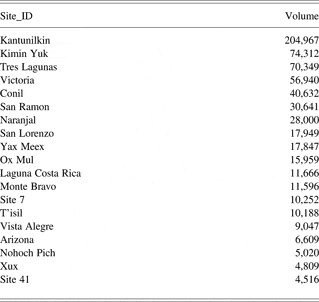
The volumetric measurements are made through the use of ArcGIS's cut and fill tool by generating two Triangulated Irregular Network (TIN) surfaces circumscribed by a basal polygon representing the building's footprint. The benefit of this method is that natural topography is accounted for and a more accurate measurement can be created. In total, the detailed mapping and volumetric calculations were carried out at 19 sites. I mapped 16 of these sites and obtained the data from the three additional sites (T'isil, Naranjal, and Kantunilkin) from preexisting datasets (Table 2).
The volumetric calculations of the Yalahau sites

SITE RANKING SCHEME
The ranking scheme presents a simplistic but useful means to begin to compare sites and, based on the chronological data, can only be applied to the Terminal Preclassic settlement data. Without excavation data to inform the discussion of site function (Ball and Taschek Reference Ball and Taschek1991), or the presence of carved monuments, numerous plaza areas per site, ballcourts, or detailed demographic data (Dunning Reference Dunning1992; Garza Tarazona and Kurjack Reference Garza Tarazona and Kurjack1980; Kurjack and Garza Tarazona Reference Kurjack, Tarazona and Ashmore1981), the settlement data were used to generate a four-tiered site hierarchy. While the choice of four ranks was arbitrary, it provides a useful heuristic device that does reveal some of the major culturally significant differences between sites in the region. I did not integrate the Yalahau data into the preexisting four-tiered site-ranking scheme developed by Kurjack and colleagues (Garza Tarazona and Kurjack Reference Garza Tarazona and Kurjack1980; Kurjack and Garza Tarazona Reference Kurjack, Tarazona and Ashmore1981) for Yucatan because all of our sites would have been in the Rank III or Rank IV category. The utility of a two-tiered ranking system seemed extremely limited. In an effort to avoid confusion between the Yalahau and Yucatec ranking schemes, the Yalahau system uses Arabic numerals in lieu of Roman numerals. The site ranks in the Yalahau region range from Rank 1, the most politically powerful, to Rank 4, dispersed farming hamlets (see Figure 2).
The ranking system combines quantitative data from the volumetric calculations with qualitative factors based on the presence or absence of certain architectural features. The presence or absence of pyramidal structures provides a culturally salient factor to differentiate Rank 4 (no pyramidal structure) from Rank 3 sites. Pyramidal structures, since their inception in Mesoamerica, have been foci for ritual practices associated with deities as well as with venerated ancestors (R. Joyce Reference Joyce2004; McAnany Reference McAnany1995). Regardless of the size of the structure, its construction makes a profound statement about a group's connection to that particular space. These structures materialized an enduring sense of community (A. Joyce Reference Joyce, Hendon and Joyce2004, Reference Joyce and Blomster2008; R. Joyce Reference Joyce2004; Pauketat Reference Pauketat, Dobres and Robb2000), and their absence at a site was deemed to be significant when discussing political relations between sites (see below). Of the 93 sites present in the regional sample, 47 of them did not contain observable pyramidal structures. In general, Rank 4 sites consist of dispersed residential and ancillary mounds.
Rank 3 sites are the most heterogeneous of the four ranks. A total of 38 sites were assigned to the Rank 3 status. Aside from the presence of a pyramidal structure, sites with volumetric sums below 30,642 m3 were considered to be in this category (Table 2). Since no Rank 4 sites were intensively mapped, I divided the summed volumetric calculations into three categories using the Jenk's Natural Breaks statistical algorithm in ArcGIS. Of the 19 sites where volumetric data were collected, there was a clustering of values between 4,516 m3 and 30,641 m3 at 14 sites. Of these 14 sites, 12 seemed to be qualitatively distinct from those sites with greater values. The two exceptions were San Ramon, which had a volume of 30,641 m3 and a pyramidal structure that measures 15 m in height (the second tallest in the region) and Naranjal, which I discuss below. In addition to these 12 sites, 26 of the other sites visited were classified as Rank 3. Once again, this was due to the presence of at least one pyramidal structure along with a qualitative assessment of the site's perceived size. None of these sites approach the scale of monumentality observable in the Rank 2 and Rank 1 sites.
The distinction between Rank 3 and Rank 2 sites is based mainly on the volumetric data. Sites that had between 30,642 m3 and 74,312 m3 of fill were classified as Rank 2 sites. Volumetrically speaking, five sites fell into the Rank 2 category: Kimin Yuk, Conil, Tres Lagunas, Victoria, and San Ramon. I, however, added Nohcachi. While I only briefly visited Nohcachi, it was a sizable site in terms of its monumental architecture and appears to rival other Rank 2 sites.
Finally, there are two Rank 1 sites, Kantunilkin and Naranjal. Volumetrically, Kantunilkin appears to be almost three times as large as the next largest site in the region. The site's advanced state of destruction, due to events in the recent past, is a severe handicap when discussing this site's important role in regional politics. I had to reconstruct the volume of the five largest structures based on Ramos' and Sanders' survey work. In addition to the sheer size of its monumental architecture, Kantunilkin possesses one of the two examples of vaulted architecture present in the region. At Kantunilkin, the lone vaulted room recorded is found atop one of the pyramidal structures.
The only other vault in the region is found at Naranjal. The promotion of Naranjal to a Rank 1 position was not based solely on the presence of the vault, but the presence of other architectural features that supported its importance. Naranjal is the only site with evidence of intra- and inter-site sacbeob. A short intrasite sacbe section was identified at T'isil (Sorensen Reference Sorensen2010), but it was nothing like the 3 km sacbe connecting the site center of Naranjal to the community of San Cosme. In addition to the presence of sacbeob and a vault, Naranjal, including the outlying Box Ni group, has 11 structures constructed in the megalithic style, the highest number of any site in the region. I feel that the low volumetric sum for Naranjal is a result of my decision to measure the volume of only the five largest structures at each site. At the Rank 2 sites, the monumental architecture is impressive, but there are usually no more than three or four sizable structures that constitute the sum of the monumental architecture at the site. If we were to sum the volume of the 10 largest structures, I think Naranjal's volumetric value would more closely reflect its position as a Rank 1 center (Dominique Rissolo, personal communication 2006). Unfortunately, I cannot calculate these values due to problems with the Naranjal map data. These features, I believe, supersede the volumetric calculation, which was 28,000 m3 and would have placed Naranjal on the border between Rank 3 and Rank 2 sites if considered alone (see Table 2). That said, the subsequent discussion of the Terminal Preclassic period is based on the ranking system developed above.
INTERPRETING THE TERMINAL PRECLASSIC POLITICAL LANDSCAPE
Trying to understand the political role of places, I am presented with a series of communities positioned across the landscape of the Yalahau region. The maps of the monumental architectural cores of these communities represent my single most important data set. Before beginning a discussion of the political role of monumental architecture, it is important to first define what is meant by the term “monumental.” Here I focus on the relative size of the architecture to that of the site as a whole. To be described as “monumental,” the structure must be significantly larger than the majority of the structures at the site. This is not a quantitative assessment that can be applied to all sites like a mathematical formula but a qualitative one. Unlike Bruce Trigger's (Reference Trigger1990:119) definition of monumental architecture that claims that the “scale and elaboration exceed the requirements of any practical functions that a building is intended to perform,” I contend that the impressive scale and elaboration did serve important “practical” functions, which were political and religious and will be investigated below.
I use the maps of these monumental site cores as a means to elucidate patterns in the built environment, both at the level of the individual structure, by investigating architectural styles, as well as at the site level through the spatial relationships between buildings that constitute the site plan. Both the architectural styles and site plans are then compared between sites in hopes of better elucidating potential sociopolitical relations among sites. How we theorize about the built environment affects the way we, as archaeologists, interpret the maps that we make. These buildings were not passive backdrops for past social actions but were actively engaged in the continual production of society.
By taking a relational approach, the built environment emerges from its passive role and becomes an active participant in the complex relationships between social structures and active agents (Giddens Reference Giddens1984; Lefebvre Reference Lefebvre1991; Pred Reference Pred1990). It is this notion of the dialectical relationship between society and the built environment that the relational approach brings into focus. Following this approach, simple descriptions of the physical attributes of space no longer suffice as explanation because those attributes only have meaning through their articulation with people's actions, experiences, and memories. “Space is not a scientific object removed from ideology and politics; it has always been political and strategic… Space has been shaped and molded from historical and natural elements, but this has been a political process” (Lefebvre Reference Lefebvre1976:31). Not only is the creation of space a political process, but space in turn creates and recreates political relations. In this role the built environment is “[i]nscribed with the strategies and intentions of their producers” (Lopiparo Reference Lopiparo2005:21), and these strategies and intentions are what we are trying to discern, while recognizing that there are unintended consequences to these actions (Joyce Reference Joyce, Dobres and Robb2000; R. Joyce Reference Joyce2004).
To begin to understand these strategies and intentions and how they created an aesthetic of place, we must turn to how the ancient Maya conceptualized monumental architecture and the built environment. It is clear that “Maya rulers used monumental architecture…to make pointed statements reinforcing the strength of their sovereignty in the minds of both peers and subordinates” (Ashmore Reference Ashmore, Danien and Sharer1992:175). These ideological statements were often couched in the religious belief system of the day and its surrounding rituals as a means to legitimize the ruler's paramount place in the social hierarchy (Ashmore Reference Ashmore, Hanks and Rice1989, Reference Ashmore1991). The cosmological associations between these buildings and the more expansive sacred landscape of the ancient Maya cannot be easily divorced from the more specific religious references to deities or ancestors contained within particular monumental buildings, often as evidenced in caches or inscriptions (Lucero Reference Lucero2007). These structures, as Houston (Reference Houston and Houston1998:521) notes, were conceptualized as animate objects and were infused with ch'ulel, a spiritual force akin to the Polynesian concept of mana (Ringle Reference Ringle, Grove and Joyce1999).
While acknowledging the sacred nature of these buildings, their construction was also a social and political act. The practices of monumental construction were part of a series of rituals that served at a community level to build social cohesion by creating a shared sense of community identity while reinforcing and naturalizing asymmetrical social relations (Pauketat Reference Pauketat, Dobres and Robb2000, Reference Pauketat2001; Webster Reference Webster and Houston1998:26–27). It is hard to envision the commoners, especially during the Preclassic period, being “hoodwinked…into building massive reminders of their humble station in life” (Ringle Reference Ringle, Grove and Joyce1999:187) by an all-knowing elite. These buildings were extremely meaningful to communities, not just the elite. They were the locus of rituals such as ones honoring apotheosized ancestors or tutelary deities, and the rituals performed in and around these buildings insured, among other things, that fertility would be abundant for community members.
Participation in these communal projects, therefore, is best conceptualized as a requirement for community membership (see Redfield and Villa Rojas [Reference Redfield and Rojas1934:78–86] for an analogous discussion of community labor, or fagina). The various roles involved in these tasks, the architect/planner, the lithic specialists shaping veneer stones, the people cutting down trees to burn to make plaster, and the artisans painting the stuccoed façade, to name a few, represented a cross-section of the hierarchically ordered social world of an ancient Maya community. Recognizing the multiple aspects of a person's identity (see Hutson Reference Hutson2010), these large-scale communal projects actively constituted an aspect of a person's social identity tied to his/her task(s), at the individual level (see Dobres Reference Dobres2000), and reinforced the asymmetrical power relations present within the society. At the same time, though, a shared identity was created at the group level that transcended the hierarchical social structures. Identity is constructed not only through actions but through the shared social memory created in such tasks (Barrett Reference Barrett, Knapp and Ashmore1999; Connerton Reference Connerton1989; Crumley Reference Crumley, Knapp and Ashmore1999; Hendon Reference Hendon2010; Tilley Reference Tilley1994; Van Dyke and Alcock Reference Van Dyke and Alcock2003). Following the construction process, the rituals conducted in these monumental spaces continued to be intimately linked to the construction of a shared community identity that was critical to the continued creation of a sense of “place” that endured in people's memories.
Intimately linked with this construction of a community identity was the “style” of the built environment, or the “discursive aesthetics of place” (A. Smith Reference Smith2003:5). I would hazard that the external form of buildings and the artistic styles of the corpus of iconographic elements on buildings, like the patterns on one's clothes, were immediately recognizable to members of that community and materialized an enduring sense of community identity (see Lucero Reference Lucero2007). As such, variations in architectural styles were not accidental, and as Moore (Reference Moore1996:95) notes, “such intentionally obvious artifacts as public architecture should communicate information obviously.” The trick, of course, is to decipher the message(s) (see Dietler and Herbich Reference Dietler, Herbich and Stark1998). Archaeologists have fruitfully investigated how style can define and maintain social boundaries by defining group identity for some time (Bartlett and McAnany Reference Bartlett, McAnany, Canuto and Yaeger2000:103; Conkey and Hastorf Reference Conkey and Hastorf1990; Dietler and Herbich Reference Dietler, Herbich and Stark1998; Schortman Reference Schortman1989), and my investigations will proceed in this vein.
I contend that the community, or cah, should be considered the basic sociopolitical unit. While not eschewing the presence of centralized political territories, a focus on the community allows us to account better for the noncontiguous spatial nature of sociopolitical relations, especially during the Terminal Preclassic period. This contrasts with other scholars who opt to focus on the more expansive polity as the basic unit (Chase et al. Reference Chase, Chase and Haviland1990; Folan et al. Reference Folan, Hau, Marcus, Miller and Heredia2001; Marcus Reference Marcus, Feinman and Marcus1998). As Restall (Reference Restall1997:25) comments “it is the cah that is overwhelmingly important, as a geographical, political, and social unit, indissoluble in the face of variation and change.” It is the cah that is central with the world organized around it in concentric circles of decreasing familiarity. A sense of community is, arguably, very different from a shared provincial sense of identity because of the closer bonds, both spatially and socially, between community members (see Fariss 1984:138). As McAnany (Reference McAnany, Sabloff and Henderson1993:73) comments, “[a]t the heart of each political unit, and probably the primary criterion by which it was identified, was the city.” It is toward the cahob of the Yalahau region that we now turn.
DISCUSSION
As discussed, my investigations take a practice-based, relational approach that allows for a more open interpretation of the significance of spatial patterns and is a move away from the neoevolutionary, economically rational assumptions associated with central-place theory and other static, geographic models. Instead, these patterns are shaped by the complex, and at times contradictory, interweaving of factionalism, an emerging elite ideology, and the creation of a sense of community identity that both empowers all members of the community while resulting in the increased naturalization of preexisting social inequalities. A relational approach to the built environment greatly aids our attempts to tease out these critical social relations from the data at hand.
In order to recognize patterns in the built environment, I employ the emulation model as developed by Ashmore and Sabloff (Reference Ashmore and Sabloff2002). The emulation model is premised on the presence of recognizable patterns in the layout of a site's monumental architecture. These patterns are not the product of the archaeologist's mind but were culturally salient for the ancient Maya. As they state, “we have difficulty with the notion that random accretions of construction would account for the patterns that seem, on the basis of our stated selection and recognition criteria, so pervasive and consistent” (Ashmore and Sabloff Reference Ashmore and Sabloff2003:233, emphasis theirs). Following Ashmore and Sabloff (Reference Ashmore and Sabloff2002, Reference Ashmore and Sabloff2003) and other scholars (de Montmollin Reference de Montmollin1989; Dunning Reference Dunning1992; Fox Reference Fox, Brumfiel and Fox1994; Houk Reference Houk1996), I contend that repeated, recognizable patterns in the built environment provide important clues to political relations between sites. This approach is all the more applicable in areas that display a short occupational history (Ashmore and Sabloff Reference Ashmore and Sabloff2002, Reference Ashmore and Sabloff2003; de Montmollin Reference de Montmollin1989). Working under this assumption, the Yalahau region should be a perfect place to investigate the political implications of the emulation model because millennia of occupation have not created a palimpsest that completely obscures the meaningful patterns present in the built environment.
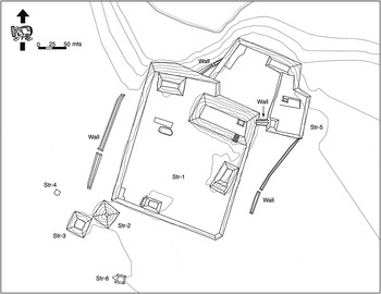
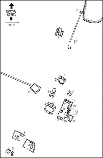
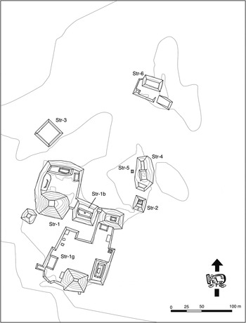
To put it simply, I observed no such recognizable patterns in the layout of sites at the regional scale. There was certainly no Yalahau site layout plan evidenced at sites that would indicate the dissemination of a “proper” site layout from a powerful center. Nor is there evidence, in terms of site layout, that sites in the region were specifically emulating powerful centers outside of the region. I must note, however, that many of the layout plans of powerful sites in the northern lowlands during this time are not well understood. My general impression is that across the region there is an idiosyncratic approach to site layout. The Rank 1 and 2 sites are positioned around the margins of the region (see Figure 2), and of these nine sites only three clearly display megalithic architecture: Naranjal, Tres Lagunas, and Victoria. Even among the megalithic sites there were no general trends for sites to be laid out along either a north/south or an east/west axis (Figures 6, 7, and 8). Where plaza areas were present, they were not the tightly bounded spaces found in the Late Classic period, and at times, it is difficult to describe them as formal plazas. Often, this is the result of the small size of the monumental core of these sites, as there was not a minimum density of buildings to warrant their aggregation into more formal groups. While these variations in site layout and architectural style could speak to chronological differences between the sites, they all display the same basic ceramic data suggesting a peak occupation during the Terminal Preclassic period (see above). Nor do I believe that natural topographic variation can explain these differences. Given the flat nature of the terrain, the idiosyncratic nature of the site layouts appears to be more rooted in community-level processes that were not strongly influenced by outside factors.
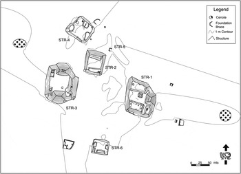
Site map of Tres Lagunas with 2 m contours.

Site map of Naranjal (after Fedick and Taube Reference Fedick and Taube1995:Figure 1.8).

Site map of Victoria with 2 m contours.

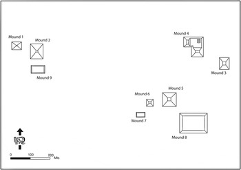
What I find interesting is how my interpretation, grounded in a more nuanced appreciation of the social and political significance of architecture and site layouts differs from one that solely uses the volumetric data. As can be seen in Table 2, the estimated volume of Kantunilkin is almost three times that of the next site. If the rank-size rule were applied, it could be used to argue that Kantunilkin should be viewed as the primate center and capital of a Yalahau polity. I contend that this overly quantitative approach misses the more culturally salient variables present in the built environment. While Kantunilkin (Figure 9) may have had closer ties with San Ramon and Conil to gain access to the north coast, the distinct approaches to community layout at the megalithic sites and Kimin Yuk (Figure 10), on the eastern side of the region, point toward the fact that these sites were not under control of those at Kantunilkin. I must admit that there is some debate as to whether Kantunilkin was, in fact, a megalithic site (Mathews Reference Mathews1998:147–149). I do not feel the evidence is strong enough to support this claim (Glover Reference Glover2006:719), but even if it was, the sites of Conil, San Ramon, and Kimin Yuk clearly do not display this architectural style. Neither do the other Rank 2 sites of El Cenote and Nochachi, but as I did not work at either of these sites, I will not discuss them here.
Site map of Kantunilkin.

Site map of Kimin Yuk with 1 m contours.

That is not to say that Kantunilkin was not a powerful center. One of the most notable patterns readily apparent when looking at the map of the region is the lack of sites close to Kantunilkin (see Figure 2). This dearth of sizable sites close to Kantunilkin, if not a sampling error, speaks to its power as a center. The concentration of population at the site would not only serve to increase the labor pool for monumental constructions but would concentrate political power at the site center. Site 58 and San Pedro are the two closest Rank 3 sites to Kantunilkin, and both are located a little over 13 km away. Both sites were briefly visited and have sizable monumental constructions. San Pedro is located south of Kantunilkin and about 4 km north of Tres Lagunas, one of the Rank 2 megalithic sites. San Pedro's basal platform, the lone structure recorded, measures 58 m by 40 m and is about 8 m tall from the ground surface to the top of its largest superstructure. In talking with community members, they reported that there had been other large structures present at the site, but these had suffered the same fate as those in Kantunilkin. Like at Kantunilkin, there was neither evidence of megalithic construction nor any mention of it, and the minimal ceramics collected at San Pedro are similar to the other regional sites.
The close proximity of San Pedro to Tres Lagunas and the differing architectural styles implemented at each presents the possibility of contentious relations between the two sites. If we can infer that the presence or absence of megalithic architecture is socially meaningful—which, as discussed, seems reasonable—then we can begin to hypothesize about conflicts and competition between megalithic and nonmegalithic sites. It is intriguing to posit that the area between these two sites was a borderland between the Kantunilkin and megalithic-influenced sites. Intensive survey between the two sites would reveal if this was an actual no-man's land. At this time, I can only speculate as to the presence of such a border.
One other line of evidence adds support to the notion that there was animosity between these sites, and potentially their neighboring Rank 1 sites. Tres Lagunas presents the only evidence of fortifications found in the region that date to this time period (Vista Alegre has evidence of Terminal Classic fortifications). There are three wall features present along the north, east, and west sides of the massive basal platform that dominate the site center (Figure 6). All three have formal entrances and are placed in tactical locations. The rubble remains were most likely the foundations for perishable palisades. The west wall terminates where the slope down to the small lake increases. The east wall terminates at the southeast corner of Structure 5, which continues to the natural drop in the terrain. The north wall is placed at the top of the steepest portion as one moves up from the lake. A south wall, however, is noticeably absent. Given the size of the foundations of the east and west walls and the clear visibility of the area to the south of Structure 1, the south wall's absence does not seem to be the result of postoccupational processes or dense undergrowth, but a result of intentional decisions made by those living at Tres Lagunas. Interestingly, it is this portion of the site that is the most open topographically. If these walls were simply meant to direct people's entrance to this sacred precinct, one would expect there to be a wall on the south side controlling access to the temple and the lowest portion of the basal platform. Is it significant that the south is open while the north side of the site is protected? It is protected not only by the walls but by the natural topography and the lakes. While highly speculative, I certainly find this intriguing, given the potential allies that lay to the south and the potential enemies who would be approaching the site from the north, although this certainly needs to be tested by further work.
While the people of Tres Lagunas may have had allies to the south at the other megalithic sites, the differing ways in which the megalithic architectural style was expressed at Tres Lagunas, Naranjal, and Victoria as well as the Rank 3 megalithic sites is the key to understanding the complex relations between them. There was no cookie-cutter model of proper megalithic site layout that disseminated from Naranjal, nor any center outside of the region for that matter. Based on his investigation of the Tenam Rosario polity, de Montmollin (Reference de Montmollin1989:231) comments that “a colony [secondary center] tends to clearly reproduce the conceptual order of its metropolis.” Often this is the result of the shorter occupation period of the secondary center. This is not the pattern we find in the Yalahau region.
I do think it was important that members of these communities chose to construct megalithic structures, and this shared tradition speaks to stronger political ties between these megalithic sites than with sites not sharing in this tradition. Following the emulation model, these sites, while not mimicking the sacred layout of a distant and powerful center such as Izamal or Ake (Lincoln Reference Lincoln1980), were clearly referencing their involvement in a more widespread phenomenon that cannot be divorced from those two centers. While acknowledging this shared aspect that surely united these sites at a certain level, I think it is critical to investigate the various ways in which political authority may have been constructed at each of these sites. I contend that the different ways in which the megalithic constructions were expressed at each site indicates that these three sites were not neatly connected in a top-down manner, but that their relations were premised on more complex and less hierarchical social negotiations.
I contend that the use of megalithic architecture to construct different types of spaces resulted in the creation of places imbued with meanings tightly wed to concepts of community identity that are arguably linked to worship of tutelary deities (Brumfiel Reference Brumfiel, Brumfiel and Fox1994:11; Fox and Cook Reference Fox and Cook1996:811; Gillespie and Joyce Reference Gillespie and Joyce1998). I draw upon an anecdote shared by Nancy Farriss (Reference Farriss1984:300) in which she describes the bitter and at times violent rivalry between residents of Seville, Spain, and their neighbors across the river. Both communities shared the Virgin Mary as their patron saint, but each had specific manifestations of the Virgin. When approached from a broad perspective, one could easily think that since both communities were Catholic and shared the Virgin Mary as their patron saint that these factors would engender strong intercommunity relations. As evidenced by Farriss' anecdote, however, this interpretation could not be further from the truth. It was the “minor” differences between the representations of the Virgin Mary that were critical to the way in which community identity was constructed. I share this example because I believe that it offers strong parallels to the possible relations between Naranjal, Tres Lagunas, and Victoria. While the broad sharing of the megalithic style spoke to shared relations at a certain level, each community appeared to have a “proper” approach to the implementation of this style in the built environment. I contend that these variations in site layout plans speak to the type of fine-grained distinctions that would have been meaningful in the construction of community identity.
These three sites are not the only ones that have megalithic constructions. As mentioned, there are at least five other smaller (Rank 3) sites in the region that display megalithic architecture, four of which are in the southern area associated with the proposed megalithic polity. These four communities are San Lorenzo, San Román, Chan Pich, and Laguna Costa Rica; the fifth, Ox Mul, is located 75 km northeast of Naranjal and 65 km from Victoria and Tres Lagunas. At each of these sites the megalithic structures are basal platforms with superstructures that appear to be residential in nature and not public in the sense that many of the megalithic buildings at Naranjal, Victoria, and Tres Lagunas were.
While we may be witnessing how certain community members were trying to bolster their legitimacy by overtly displaying their connection with larger megalithic sites, other members of the community seem to have taken a different approach. At San Lorenzo this is seen in the other large structures not constructed in the megalithic style (Structures 1, 2, and 8). The same is true at Laguna Costa Rica where Structures 1, 3, and 4 evidence the megalithic style, while Structures 2, 5, 6, and 7 display none of the characteristic attributes. At Ox Mul, Structure 2 is the only one with megalithic architecture. The evidence from San Román and Chan Pich is spotty given the brief archaeological reconnaissance done at each, but the same pattern appears to hold. These buildings, therefore, may be better conceptualized as the residences of local elite with strong ties to the larger megalithic sites. The megalithic architecture was a constant reminder to community members of their powerful “neighbors” and who within the community had closer ties with these sites.
To wrap up this admittedly speculative recreation of the relations between the megalithic sites, it needs to be stated that other sites were occupied in the area corresponding to the megalithic polity. Sites such as Arizona, Rancho Juárez (Site 41), and Santa Cruz (Site 42) all possess modest monumental architecture and yet display no sign of megalithic architecture. Rancho Juárez is located directly between Victoria and Naranjal alongside a lake and near a sizable cenote. Its position could lead one to posit that it too would evidence some examples of megalithic constructions, but none were found. In each of these cases, the constant specter of contemporaneity must be acknowledged; however, the ceramic evidence, although limited at Rancho Juárez and Santa Cruz, speaks to the same general shared ceramic tradition during the Terminal Preclassic period that is present across the region. This pattern does not appear to be the result of site function. Hutson's (2009) recent work around Uci in the northwestern part of the peninsula has documented the presence of megalithic architecture at a wide variety of sites, which supports the idea that megalithic architecture is not linked to any particular “type” of site. I contend that the lack of megalithic architecture speaks more to the noncontiguous nature of sociopolitical relations in the Maya area. As Adam Smith (Reference Smith2003) notes, Martin and Grube's (Reference Martin and Grube2000) reconstruction of Late Classic political relations based on epigraphic evidence points toward the need to move away from Theissen polygons and other such static representations of polities.
CONCLUSIONS
The Terminal Preclassic period marks the apogee of settlement and monumental construction within the region. Although our chronological understanding of this period is coarse, I have outlined here a few scenarios for sociopolitical relations between the regional sites during this time period. I took a relational approach to the investigation of the built environment to propose intriguing suppositions with the hope of further pursuing some of them in future research projects.
When investigating these data and working at the sites, I was struck by the idiosyncratic approach taken to site planning. As discussed, while site layout plans varied, there were some indications of shared ideologies evidenced by the distribution of megalithic architecture. These ideologies, which were physically manifest in aspects of the built environment, were not disseminated from a single site in a top-down manner. It is my impression that there was a tension present between the concepts of community and polity identity, and the cah appears to have been the more culturally salient building block of ancient Maya sociopolitical order.
It should not be surprising to see tensions between the polity and community, especially during the Terminal Preclassic period. This was a time of explosive population growth and increased social stratification. At the same time, this increased stratification was emerging from a seemingly more communal and egalitarian ethos (see Barber and Joyce Reference Barber, Joyce, Wells and Davis-Salazar2007; Chase and Chase Reference Chase, Chase and Grube1995; Freidel and Schele Reference Freidel and Schele1988; Joyce Reference Joyce and Blomster2008). Monumental constructions during this time period were not erected by a duped nonelite populace manipulated by an all-knowing set of elite bent on naturalizing their social position. These constructions were undertaken as a set of community-based practices and rituals, most likely tied to the sanctification of tutelary deities, which engendered a sense of community identity that was often cast in opposition to neighboring communities—which were often competing for followers (Lucero Reference Lucero2007; Ringle Reference Ringle, Grove and Joyce1999). It was this shared sense of community identity that hindered the formation of polities in the Maya area. I see this as a constant tension throughout time in the lowlands that was the cause of the dynamism that scholars such as Marcus, Freidel, and Iannone have proposed to describe Maya polities (Freidel Reference Freidel, Vogt and Leventhal1983; Iannone Reference Iannone2002; Marcus Reference Marcus, Feinman and Marcus1998). In the southern lowlands during the Preclassic period, the massive site of El Mirador emerged along with a number of other large sites in the Mirador basin. I find it quite telling that a number of these sites, including El Mirador, have massive defensive works surrounding their site cores (Hansen et al. Reference Hansen, Balcárecel, Suyuc, Mejía, Hernández, Valle, Guenter and Novak2005; Matheny Reference Matheny and Benson1986; Webster Reference Webster1976, Reference Webster1980). While there is certainly strong evidence to support the formation of a sizable Late Preclassic polity centered at El Mirador, at the same time the presence of defensive works highlight the tensions between community and polity. Even the earthworks at the giant site of Tikal (Webster et al. Reference Webster, Murtha, Silverstein, Martínez, Terry and Burnett2007) give the impression that the rulers are somehow trying to define its boundaries to create a sense of community that could be leveraged for political tribute and labor. I do think the built environment provides an excellent domain to investigate these tensions. Given the sacred and political nature of monumental constructions, they were actively engaged in the generation of political authority and can therefore provide clues into the dynamic nature of sociopolitical relations.
Finally, a discussion of the Terminal Preclassic period in the Yalahau region would be incomplete without an attempt to address the depopulation that apparently occurred at a regional scale at some point during the Early Classic period. An idea held since this pattern was first observed notes the growth of Coba as a regional power during the Early Classic (Folan Reference Folan, Folan, Kintz and Fletcher1983) coincides with the Yalahau depopulation (Fedick and Taube Reference Fedick and Taube1995:16). The growth experienced by Coba cannot be explained by in situ population dynamics, and immigration must have played a large role in its expansion. Investigating short-term population peaks and valleys in the areas surrounding the Yalahau region might provide another important clue to understanding the region's settlement history. Martos López (Reference Martos López2002) found evidence at the sites in the Calizas Industriales del Carmen (CALICA) area, along the east coast of Quintana Roo, to suggest a brief depopulation of the area between a.d. 50–250. It is interesting to posit that this coastal depopulation seemingly coincided with the apex of political developments in the Yalahau region. Following this period of growth, the Yalahau region began to experience its own problems, which could have led to people moving back out to the coast and south to Coba. The work of Hodell and colleagues (Reference Hodell, Brenner and Curtis2007) on lake cores from nearby Punta Laguna indicate a drying period at some point slightly before a.d. 250. This climatic change may have wreaked havoc on the hydrology of the region's wetlands and the ingenious water management systems that have been identified there (Fedick Reference Fedick and Bernick1998, Reference Fedick, Gómez-Pompa, Allen, Fedick and Jiménez-Osornio2003; Fedick and Morrison Reference Fedick and Morrison2004; Fedick et al. Reference Fedick, Morrison, Andersen, Boucher, Acosta and Mathews2000; Leonard Reference Leonard, Arroyo, Linares and Argón2010). If the productivity of the wetlands was adversely affected, Coba or the coast may have become much more attractive options for the region's inhabitants. These suppositions must be substantiated by fine-grained chronological data and localized paleoenvironmental data if we are to track the ebb and flow of populations across northern Quintana Roo, and I look forward to helping resolve the depopulation question in future field seasons.
RESUMEN
El Proyecto de Reconocimiento Regional del Patrón de Asentamiento Yalahau (YRSPS por sus siglas en inglés) examina las negociaciones complejas que se llevaron a cabo en la antigua sociedad maya a través de la investigación de la distribución de asentamientos, a lo largo de la región Yalahau, en el norte de Quintana Roo, México. El YRSPS difiere de la mayoría de los estudios de patrón de asentamiento en las tierras bajas mayas debido a su escala, la historia ocupacional de la región, y su orientación teórica. Este texto inicia con una breve historia cultural de la región Yalahau en donde la ocupación oscila entre el período preclásico medio (700–200 a.C.) y el período posclásico (1100–1521 d.C.). La región tuvo su apogeo durante el período preclásico terminal (75 a.C./100 d.C.–400 d.C.). Un esquema jerárquico se utilizó como sistema simple para iniciar la comparación de sitios de este período. El sistema jerárquico combina datos cuantitativos derivados de los cálculos volumétricos de las cinco estructuras más grandes en cada sitio, en combinación con factores cualitativos basados en la presencia o ausencia de ciertos rasgos arquitectónicos. Mientras que este sistema es una herramienta heurística útil, las limitantes del esquema jerárquico se exploran empleando un acercamiento enfocado en entender las relaciones dialécticas entre las prácticas sociales y el entorno construido. Especialmente, el uso de este acercamiento permite conceptualizar las complejas negociaciones que constituyeron las relaciones sociopolíticas durante el período preclásico terminal. Aun más intrigante fue el determinar la índole de las construcciones monumentales dirigidas hacia la comunidad dentro de la región. La arquitectura monumental se materializa como actividades con sentido duradero que afectan la identidad comunitaria. Este sentido de identidad compartido fue engendrado por dos aspectos, el proceso constructivo, generalmente percibido como una actividad comunal, así como por los rituales subsiguientes llevados a cabo dentro y alrededor de las estructuras. Estos rituales se enfocaron en representar una narrativa maestra de creación para la comunidad, posiblemente asociada con una deidad patronal o ancestro venerado, y como será argumentado, el estilo y disposición de las estructuras fueron importantes aspectos en la creación y mantenimiento de esta identidad comunitaria. Este escrito examina las tensiones dentro y entre comunidades mientras que las estrategias sociopolíticas se negociaron y debatieron en el continuo y complejo proceso de la constitución social.
ACKNOWLEDGMENTS
I would like to thank Traci Ardren and Alejandra Alonso for their invitation to take part in this special section. This research would not have been possible without the support of the National Science Foundation (BCS-0327455), the University of California Institute for Mexico and the United States (UC MEXUS), and Scott Fedick and Jennifer P. Mathews, directors of the YRHEP. I thank the Consejo de Arqueologia of Mexico's Instituto Nacional de Antropología e Historia (particularly Roberto Garcia Moll and Joaquin Garcia Barcena) for granting me permits to conduct the research presented in this paper. Arqlga. Adriana Velázquez Morlet, director of INAH Quintana Roo, provided invaluable assistance. In the Cancún office, I would like to thank Arqlga. María José Con Uribe, Lic. Carlos Esperón, and Lic. Karina Romero Blanco, the director of the INAH Cancún museum, for their support. I would also like to thank the people of the Yalahau region. Without their kindness and support none of this would have been possible. I thank Dominique Rissolo, Armando Anaya Hernández, William Folan, and one anonymous reviewer for their thoughtful comments on earlier drafts. Any and all errors are mine alone.