Introduction
Space-borne synthetic aperture radar (SAR) imaging has proved to be a valuable research tool in polar regions because of its ability to penetrate cloud cover, acquire imagery during the day or night, and acquire imagery at a high temporal resolution (Hall Reference Hall, Henderson and Lewis1998). SAR imagery has been used extensively to monitor sea ice, lake ice, glaciers, snow cover, and water resources (Massom Reference Massom1991; Hall Reference Hall, Henderson and Lewis1998). Initially, we were interested in monitoring lake ice melting processes in the large lakes located within the Teshekpuk Lake Special Area (TLSA) during the spring and summer of 2006. However, during data processing we discovered features in the Radarsat-1 imagery indicative of perturbations to the snow cover as a result of winter seismic surveys.
Here, we present preliminary findings on detection of seismic surveys conducted in the TLSA during April and May of 2006 while the tundra was still snow covered. We show that the Radarsat-1 imagery can be used to infer features associated with winter seismic surveys such as the seismic survey grid profile, camp-move trails, the location of active campsites and former campsite footprints, and in one instance, the vehicles en route. Thus, the SAR imagery could be used to monitor winter seismic surveys providing a valuable tool to land and resource managers as petroleum-based exploration efforts increase in the National Petroleum Reserve-Alaska (NPR-A).
Regional Setting
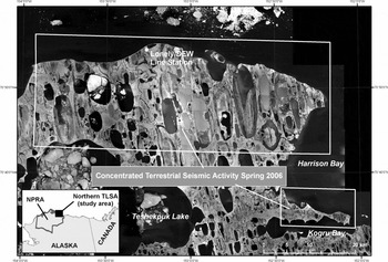
The NPR-A spans an area of 9.67 million hectares on the North Slope of Alaska, bounded by the Brooks Range to the south, the Colville River to the east, and the Beaufort and Chukchi Seas to the north and west, respectively. It is typically snow covered for nine months of the year. The NPR-A was initially established as the Naval Petroleum Reserve Number 4 in 1923 and set aside as an oil reserve. Petroleum exploration has occurred periodically since its inception and in 1976 it was renamed the National Petroleum Reserve-Alaska (NPR-A) with the passage of the Naval Petroleum Reserves Production Act. The TLSA is located in the northeastern portion of the NPR-A (Fig. 1) and provides a critical breeding habitat for migratory waterfowl (Bollinger and Derksen Reference Bollinger and Derksen1996), calving grounds for caribou (Kelleyhouse Reference Kelleyhouse2001), and is believed to be rich in petroleum reserves (Bird and Houseknecht Reference Bird and Houseknecht2002).
Map showing the location of the study area within the Teshekpuk Lake Special Area (TLSA), northeast portion of the National Petroleum Reserve Alaska (NPRA) (inset) along with the locations of the concentrated terrestrial winter seismic survey activity conducted during April and May 2006 (white boxes).

Seismic exploration
Oil and gas exploration in the NPR-A began in the late 1940s and was often conducted during the summer, which entailed bulldozing roads directly into the tundra causing severe damage to the land surface. During the 1970–1980s, exploratory techniques evolved to a state in which much of the activity occurred during the winter using 2-D seismic data acquisition techniques. Today, exploration activity still largely occurs during the snow covered months, yet more recently entails the use of 3-D seismic data acquisition and 4-D visualisation technologies (DOE, 1999).
In order to acquire 3-D seismic data, a grid profile with a line spacing of a few hundred meters is established and multiple passes are made by vehicles carrying vibrating and receiving equipment within the rectilinear grid to survey the geological and geophysical characteristics of the subsurface (National Research Council 2003). The vehicles associated with the collection of 3-D seismic data consist of tracked vibrator units, tracked recording vehicles, geophone carriers, and tracked personnel carriers (bombardiers) for the surveys as well as the units required for the mobile survey camp which consist of strings of camp and fuel sleighs pulled by D-7 Caterpillar tractors (Felix and Raynolds Reference Felix and Raynolds1989; Raynolds and Felix Reference Raynolds and Felix1989; National Research Council 2003).
SAR imagery
SAR sensors typically operate in the microwave region of the electromagnetic spectrum, from wavelengths of 1 mm to ∼1 m. Because a SAR sensor contains its own energy source and operates at relatively long wavelengths, the backscattered signal from an imaging SAR system is much less affected by rain or clouds than an optical sensor. In addition to image geometry and sensor characteristics (wavelength, incidence angle, etc.), SAR backscatter is primarily controlled by terrain slope, surface roughness, and dielectric constant (Ulaby and others Reference Ulaby, Moore and Fung1986).
We used radar data from the Canadian Space Agency's Radarsat-1 sensor, which is a C-band sensor with a wavelength of 5.66 cm and has a horizontal send and horizontal receive (HH) polarization. In addition, the Radarsat-1 sensor can be steered to view the Earth's surface with different look angles ranging from 20 degrees to 50 degrees from the vertical, thus reducing its temporal repeat pass frequency to several days.
The raw signal data for the Radarsat-1 scenes were provided by the Alaska Satellite Facility and processed into SAR backscattering intensity images using the GAMMA processing software (Werner and others Reference Werner, Wegmuller, Strozzi and Wiesmann2000). A Lee speckle suppression algorithm with a 3 × 3 kernel size was used to reduce the amount of speckle noise in the images (Lee Reference Lee1986). While still in SAR coordinates (slant-range/azimuth) the images were multi-looked to a pixel size of 40 × 40 m. Then, using the orbital characteristics unique to the Radarsat-1 imagery and U.S. Geological Survey digital elevation model (DEM) data (with a resolution of 30 m, a specified horizontal accuracy of 60 m, and root mean square vertical error of 15 m) we created a synthetic SAR image from the DEM. Using cross-correlation techniques, the SAR data, still in slant-range/azimuth SAR coordinates, were converted to a UTM map coordinate system (Werner and others Reference Werner, Wegmuller, Strozzi and Wiesmann2000). Also, during geo-registration the elevation postings in the DEM were used for terrain-correction of the SAR images. The terrain-correction procedure is necessary to rectify the variable ground postings of the SAR pixels. The resulting Radarsat-1 SAR images have pixel spacings equal to that of the DEM (30 m) and the terrain-corrected SAR backscattering intensity images were then used to map and study seismic survey activities in the northern TLSA.
Observations and discussion
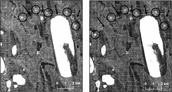
SAR imagery detected an array of high backscattering values as a result of perturbations to the snow cover, which we interpreted as being associated with winter seismic surveys, due to the regular grid spacing of ∼400 meters. The grid profile, camp-move trails, and campsite locations associated with seismic surveys are visible in the Radarsat-1 imagery (Fig. 2). These features are interpreted as such since no ice roads were constructed, nor exploratory wells drilled, in the TLSA during the spring of 2006 (D. Yokel, personal communication, June 2007).
Radarsat-1 SAR images captured on 23 April 2006 (left) and 25 April 2006 (right). Apparent in the SAR images are the grid profile associated with subsurface mapping, camp-move trails indicated with a black arrow, and the location of campsites circled in black. Note the progression of camp to southwest (north is to the top) in the left portion of the image between the 23 and 25 April 2006 and the high backscatter and square shape associated with the feature. This could indicate double-bounce SAR backscattering as a result of camp sleigh configuration.

Our hypothesis is that the increase in the observed radar backscatter associated with the grid profile, camp-move trails, and campsites is due to differences between the snow surface roughness, the snow compaction and structure, and the elevation of the impacted areas relative to the surrounding, unimpacted snow cover. However, without detailed information on the characteristics of the snow cover and the alteration to the snow cover created by the vehicles during image acquisition, the relative importance of these factors is unknown. It is also possible that vehicles, trailers, and other features associated with the survey activity could produce double-bounce SAR backscattering and play an important role in increasing SAR backscattering values. Several campsite footprints are visible on the scene from 23 April 2006; however, the most westerly site has much higher backscatter values and is more square in shape than the footprints to the east. This could indicate double-bounce SAR backscattering as a result of the configuration of camp sleighs and trailers when aligned at a campsite and could reveal the exact location of the camp on a given day. Analysis of the scene acquired on 25 April 2006 shows the progression of the camp to the southwest and the same high backscatter and square shape of the ‘newly’ detected campsite relative to its former location (Fig. 2).
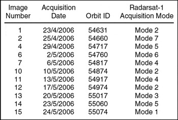
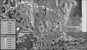
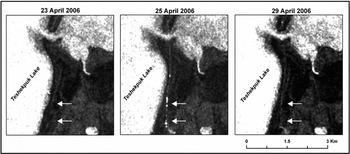
The temporal frequency of the dataset allowed us to monitor the progression of the mobile survey camps across the snow covered tundra over a one month period (Table 1; Fig. 3). The first scene acquired for the TLSA was on 23 April 2006. This scene revealed nearly 46 km of camp-move trails and the location of eleven campsite footprints and possibly the active campsite. The next available scene was acquired on 25 April 2006, in which an additional 20 km of camp-move trails were detected as well as the location of two more campsites north of Teshekpuk Lake. This same scene also allowed the detection of a camp-move trail trending southeast from the eastern margin of Teshekpuk Lake, and what appear to be vehicles en route (Fig. 4). It is likely that this camp-move trail is an extension of the trail that moved onto Teshekpuk Lake from the north, however, due to the high-backscatter over much of Teshekpuk Lake as a result of free floating lake ice it was not possible to discern clearly the linkage between these two trails. Following the activity on the 25 April 2006 it appears that the remainder of the seismic crews that had been concentrated north of Teshekpuk Lake progressed in a southeastern direction towards Kogru Bay and nearly 54 km of trails were detected over a four day period as well as the location of four additional campsites. The next available scene covering this area was acquired on 10 May 2006. This image revealed a newly created grid profile on the peninsula of land north of Kogru Bay, twelve km of camp-move trails, and an additional campsite. Between 10 May 2006 and 13 May 2006 a further ten km of trails were detected along with one more campsite. Analysis of scenes acquired over the TLSA between the 13 May 2006 and 24 May 2006 did not reveal additional exploration activity.
Radarsat-1 images acquired for the study area from 23 April 2006 to 24 May 2006.

Orthorectified aerial photography acquired in 2002 serves as a basemap for the overlay of camp-move trails and campsite locations that were derived from SAR images acquired between 23 April 2006 and 24 May 2006. The camp-move trails (lines) and campsite locations (points) are classified by the date at which they were first apparent in the SAR imagery. A long stretch of trail and a number of campsite footprints were already evident in the first image acquired on 23 April 2006. The activity initially progressed westerly and then southeasterly across the study area.

Radarsat-1 image time series captured along the eastern margin of Teshekpuk Lake (hatched box in Fig. 3). The 23 April 2007 image shows that no trail was detected here, whereas the 25 April 2007 image reveals a trail as well as what is interpreted as the vehicles en route (white arrows). In the 29 April 2007 image the vehicles are no longer apparent and the trail is still somewhat visible. The imagery also shows that when these trails traverse areas of free-floating ice (high backscatter), the ability to detect the trails is limited.

Conclusions
Radarsat-1 SAR imagery acquired over the TLSA within the northeast portion of the NPR-A during the spring of 2006 revealed various aspects associated with winter seismic surveys for petroleum resources (grid profile, camp-move trails, campsite footprints, the location of active campsites, and in one instance, the vehicles en route). Multi-temporal radar imagery allows for the identification of activities associated with winter seismic surveys and provides land and resource managers with a tool that can be used to track the progress of exploration activities during the winter and spring and to provide exact locations of trails and campsites that can be used to monitor the potential cumulative effects to the tundra surface over time.
Acknowledgements
Radarsat-1 images are copyright 2006 the Canadian Space Agency (CSA), and were provided by Alaska Satellite Facility (ASF). This research was supported by funding from the USGS Alaska Science Center, USGS Land Remote Sensing Program, and USGS contract O3CRCN0001. We thank ASF for their special effort and outstanding support in programming Radarsat-1 images.