INTRODUCTION
The call for better spatial management of our marine environment is growing globally. Specifically, there is momentum for the establishment of networks of marine protected areas (MPAs) driven by International, European and (within the UK) national initiatives, as well as a need to identify the distribution of vulnerable marine ecosystems (VMEs). At an international level the Convention on Biological Diversity (CBD) highlights the establishment of marine and coastal protected areas as one of its key themes. Signatories to the CBD are committed to the goal adopted at the 2002 World Summit on Sustainable Development to establish representative networks of protected areas in the maritime environment by 2012. At a regional level Annex V (on the Protection and Conservation of the Ecosystems and Biological Diversity of the Maritime Area) of the 1992 Convention for the Protection of the Marine Environment of the North-East Atlantic (OSPAR Convention) gives the OSPAR Commission a duty to develop means, consistent with international law, for instituting protective, conservation, restorative or precautionary measures related to specific areas or sites or related to particular species of habitats. A target date of 2010 has been set by OSPAR contracting parties to achieve ‘an ecologically coherent network of well managed Marine Protected Areas’. At a European level the EC Habitats and Species Directive (92/43/EEC) requires the establishment of protected areas (Special Areas of Conservation (SACs)) for habitats and species, listed under Annex I and Annex II respectively of the directive, in areas of sea under the jurisdiction of member states. In addition the Marine Strategy Framework Directive requires member states to achieve good environmental status in Europe's seas by 2020.
Criteria by which MPAs can be selected have been set out by the world conservation union (IUCN, 1994). These criteria include naturalness, biogeographical importance, ecological importance, economic importance, scientific importance, international or national significance and practicality/feasibility. An emerging central theme of the objectives of MPA selection is the concept of representativeness, or representative systems of MPAs (and similar terms, e.g. representation and representivity; Kelleher et al., Reference Kelleher, Bleakley and Wells1995; Boersma & Parrish, Reference Boersma and Parrish1999). IUCN guidelines for highly protected areas (categories Ia, II, and III), including marine areas, now include representativeness as a major criterion (IUCN, 1994).
The current call for representativeness as a major criterion for MPA design has as a prerequisite, an understanding of the distribution (e.g. maps) of that which we wish to represent. From an ecological and ideological perspective the aim is to represent examples of all biological and functional diversity within a reserve network. From a practical perspective this is completely impossible, since biological diversity operates at a range of scales and we do not know the extent of biological diversity, nor its distribution and function. Representation goals therefore generally aim to represent patterns of biodiversity at nominated spatial and/or organizational scales. In this respect then, we use the term ‘representativeness’ in its strictest sense as defined by Stevens (Reference Stevens2002), to mean representation of every type of ‘habitat’ occurring in an area under consideration, where ‘habitat’ is defined, following Stevens (Reference Stevens2002), the scale at which management of marine protected areas occurs, i.e. the local (10s km) or finer scales. Mapping of biological diversity at these spatial scales requires the use of surrogates, for which known distribution is achievable, to represent biological, and to a degree, functional diversity. Surrogates that have been used for biological diversity include biogeographical region (Allee et al., Reference Allee, Dethier, Brown, Deegan, Ford, Hourigan, Maragos, Schoch, Sealy, Twilley, Weinstein and Yoklavich2001; Roff & Taylor, Reference Roff and Taylor2000; Butler et al., Reference Butler, Harris, Lyne, Heap, Passlow and Smith2001), depth (Allee et al., Reference Allee, Dethier, Brown, Deegan, Ford, Hourigan, Maragos, Schoch, Sealy, Twilley, Weinstein and Yoklavich2001; Roff &Taylor, 2000; Butler et al., Reference Butler, Harris, Lyne, Heap, Passlow and Smith2001), seabed features/geomorphology (Greene et al., Reference Greene, Yoklavich, Starr, O'Connell, Wakefield, Sullivan, McRea and Cailliet1999; Allee et al., Reference Allee, Dethier, Brown, Deegan, Ford, Hourigan, Maragos, Schoch, Sealy, Twilley, Weinstein and Yoklavich2001; Butler et al., Reference Butler, Harris, Lyne, Heap, Passlow and Smith2001; Harris, Reference Harris, Todd and Greene2007), substratum (Allee et al., Reference Allee, Dethier, Brown, Deegan, Ford, Hourigan, Maragos, Schoch, Sealy, Twilley, Weinstein and Yoklavich2001; Roff & Taylor, Reference Roff and Taylor2000; Connor et al., Reference Connor, Allen, Golding, Howell, Lieberknecht, Northen and Reker2004; Davies et al., Reference Davies, Moss and Hill2004) and biological assemblages (Connor et al., Reference Connor, Allen, Golding, Howell, Lieberknecht, Northen and Reker2004; Davies et al., Reference Davies, Moss and Hill2004; Harris, Reference Harris, Todd and Greene2007). These surrogates also operate, and are as a result mappable, at a variety of spatial scales, and are often arranged into hierarchical classification systems. Where only data of coarse resolution are available, higher level surrogates, usually a measure of the physical environment, are used to represent variation in biological diversity. These coarse scale surrogates inevitably do not effectively represent the biological variation present. Consequently selection of MPAs based on coarse level surrogates alone may well fail to represent even known biological diversity (Ward et al., Reference Ward, Vanderklift, Nicholls and Kenchington1999; Stevens & Connolly, Reference Stevens and Connolly2004; Williams et al., Reference Williams, Bax, Kloser, Althaus, Barker and Keith2009). As a result, and where data are available, finer level surrogates, such as biological assemblages, are used.
While biological assemblages could be defined on a site to site base, as surrogates for the biological diversity of the area, it is more useful, in terms of marine environmental management and MPA network design, to use consistent terms across broad regions. More specifically, in order that the maps, on which measures of representativeness are derived, are comparable between areas/regions, the units on which they are based need to be consistently defined, and ideally as part of a classification system. While there are well known descriptions of assemblages for shallow water environments following the works of Peterson (Reference Petersen1913), Jones (Reference Jones1950), Glémarec (Reference Glémarec1973) and others, few such descriptions of deep-sea benthic assemblages have been attempted (Le Danois,Reference Le Danois1948; Laubier & Monniot, Reference Laubier and Monniot1985). It should be noted however, that a number of deep-sea benthic assemblages and communities are widely recognized, e.g. cold-water coral reefs and ostur (sponge communities), while more are being described through the political process (e.g. coral gardens (OSPAR MASH07/4—Agenda item 4)).
The increasing encroachment of anthropogenic activities on the deep-sea marine environment (Glover & Smith, Reference Glover and Smith2003; Davies et al., Reference Davies, Roberts and Hall-Spencer2007) has brought into sharp focus the need to conserve and manage this environment appropriately. Internationally, establishing networks of MPAs to conserve deep-sea and high seas biodiversity (Cripps & Christiansen, Reference Cripps, Christiansen, Thiel and Koslow2001; Gjerde & Breide, Reference Gjerde and Breide2003; Scovazzi, Reference Scovazzi2004; Williams et al., Reference Williams, Bax, Kloser, Althaus, Barker and Keith2009) are receiving high priority. In order that the objective of representativeness can be applied to MPA network design within the deep-sea and high seas it is vital that a hierarchical classification system is developed that is applicable to the deep-sea. While a number of classification systems exist that are applicable to the deep-sea (Greene et al., Reference Greene, Yoklavich, Starr, O'Connell, Wakefield, Sullivan, McRea and Cailliet1999; Allee et al., Reference Allee, Dethier, Brown, Deegan, Ford, Hourigan, Maragos, Schoch, Sealy, Twilley, Weinstein and Yoklavich2001; Roff & Taylor, Reference Roff and Taylor2000; Butler et al., Reference Butler, Harris, Lyne, Heap, Passlow and Smith2001; Davies et al., Reference Davies, Moss and Hill2004; Madden et al., Reference Madden, Goodin, Allee, Finkbeiner and Bamford2008), few incorporate units at the biological assemblage level. This is at least in part a result of the lack of described biological assemblages.
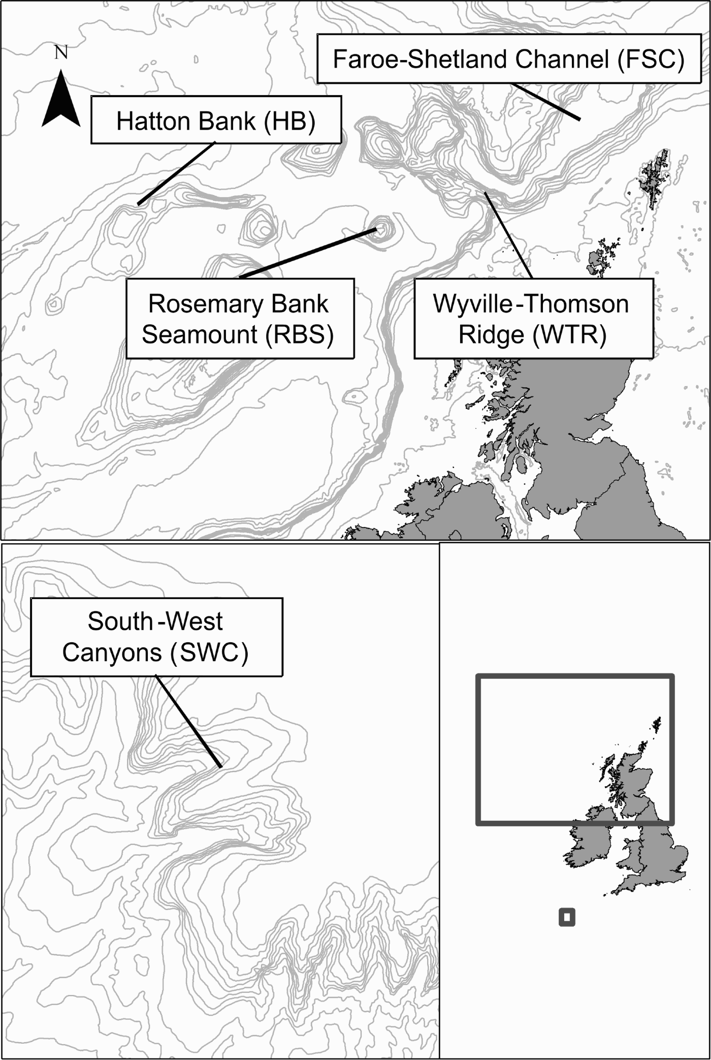
The aim of the present study is to provide descriptions of deep-sea epibenthic megafaunal assemblages, which are scientifically based, exist on a scale relevant to mapping efforts and the cost-effective methods commonly used in habitat mapping (e.g. broad scale acoustic survey coupled with video groundtruthing) (10s of metres), and can be easily slotted into existing hierarchical classification systems. The European Continental Margin to the west of the British Isles is one of the best known regions of the deep-sea in the world, and has been described as ‘the cradle of deep-sea biology’ (Gage, Reference Gage2001) (Figure 1). Our in-depth understanding of the ecology of this region of the deep-sea makes this area an ideal place from which to describe deep-sea benthic biological assemblages. The study is limited to 1000 m; since most anthropogenic activities occur above this depth, therefore the need for assemblage descriptions is arguably most pressing for this region.
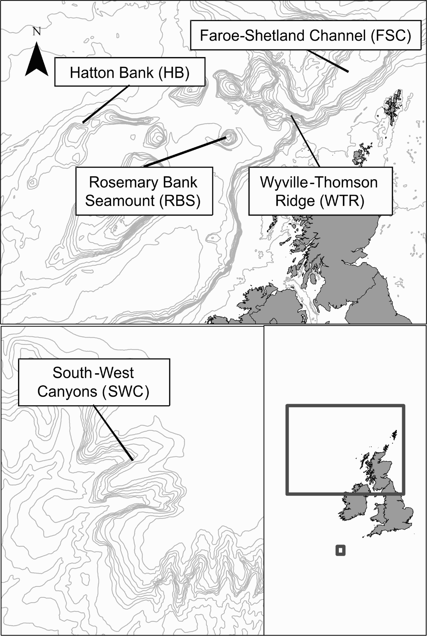
The European continental margin west of the British Isles, with sample locations identified. Bathymetry lines are at 100 m intervals to 1000 m, then at 500 m intervals. Projected using the British National Grid.
MATERIALS AND METHODS
Site description
The European Continental Margin to the west of the British Isles is topographically complex (Figure 1). Within this region lie three seamounts (sensu stricto), numerous banks and hills, canyons, and the Wyville-Thomson Ridge (WTR), which separates the Faroe–Shetland Channel (FSC) basin from the Rockall Trough basin. The Rockall Trough is bounded to the west by the Rockall–Hatton Plateaux, to the north by the WTR and a chain of banks and seamounts, and to the east by the European Continental Shelf. It opens to the south onto the Porcupine Abyssal Plain. The trough shallows progressively from 4000 m in the south-west to 1000 m in the north-east where it meets the base of the WTR. The FSC is a deep basin separating the Faroe Plateau from the Scottish continental shelf. The FSC broadens and deepens north-eastward from 90 km wide, 1000 m deep at the base of the WTR to 190 km wide, 1500 m in the north, where it opens into the Norwegian Sea (Figure 1). The hydrographic regime is complex with warm waters of Atlantic origin flowing north-eastward, overlying cold waters of Arctic origin flowing south-westward (Turrell et al., Reference Turrell, Slesser, Adams, Payne and Gillibrand1999). The boundary between these water masses is dynamic occurring between 400 and 600 m on the eastern flank of the channel.
Data collection
Collection of biological data from the Faroe–Shetland Channel Continental Slope (FSC), WTR, Rosemary Bank Seamount (RBS) and Hatton Bank (HB) was undertaken over a two month period (August–October 2006) using the commercial research vessel MV ‘Franklin’. Collection of biological data from the SW Canyons (SWC) was undertaken over a thirteen day period in June, 2007 on the RV ‘Celtic Explorer’ (Figure 1). One hundred and thirty-nine video transects were undertaken in total (Table 1). Transects were selected to cover a range of substrates, depths and geomorphological features using existing multibeam bathymetry and backscatter data.
Distribution of sample effort on each feature within the study area.

For both vessels the Seatronics drop frame system was deployed from the starboard side of the vessel. The system comprised an integrated DTS 6000 digital video telemetry system, which provided a real time video link to the surface, a digital stills camera (5 mega pixel, Kongsberg OE14-208) and a colour video camera (Kongsberg OE14-366). Both video and stills cameras were mounted opposite each other at an oblique angle (video: 24°; stills: 22°) to the seabed to aid in species identification. Sensors monitored depth, altitude and temperature, and an Ultra Short Base Line (USBL) beacon provided accurate position data.
Each transect was nominally 500 m in length, however deviations from planned transect lengths did occur (i.e. if the terrain or currents became too difficult to control the camera). For the majority of tows, vessel speed was approximately 0.5 knots (minimum 0.3 and maximum 0.7 knots), with most tows lasting between 0.5 and 1.5 hours. The drop frame was towed in the water column between one and three metres (dependant on substrate type and currents) above the seabed. At the beginning of each tow, starting from when the sea floor became visible, a 2–3 minute period was allowed before sampling, to enable the camera to stabilize before commencing the transect. At approximately 1 minute intervals the camera was landed on the seabed and a still image obtained, exceptions were when the substratum was extremely (1) soft (silt clouds); (2) rocky, uneven, delicate (coral); or (3) descending a cliff face; here the camera was not landed and images were between 1 and 3 m above the seabed. Images taken at 1 minute intervals are hereafter referred to as ‘sample’ images.
To maximize the number of biological assemblages recognized, images were obtained where habitat boundaries occurred. In addition opportunistic images were obtained to aid in species identification. The fields of view of both the stills and video cameras were calibrated using a gridded quadrat of known dimensions. Calibrations were made for ‘on bottom’ (drop frame fully landed on the seabed) and at 1 m, 2 m and 3 m above the seabed to aid in quantitative analysis. Field of view size was as follows: on bottom= 2247 cm2, 1 m = 6423 cm2, 2 m = 24953 cm2, 3 m = 56144 cm2.
Data extraction and analysis
Identification of species from images is difficult and in many cases impossible without obtaining physical samples. However, securing such samples is particularly problematic when working in the deep-sea. Consequently here 312 distinct morphospecies were defined, catalogued and used in subsequent image analysis. In general morphospecies correspond to species, however for some groups (e.g. sponges) it may correspond to genus, family or higher taxonomic level. The morphospecies catalogue is available from the authors upon request.
All ‘sample’ images and images obtained at habitat boundaries were reviewed and poor quality images removed. The remaining images were quantitatively analysed in the following manner. All organisms >1 cm were identified and counted. For encrusting forms percentage cover was calculated using a calibrated grid superimposed over the image. For the most part the images analysed were of the same size field of view, although in some cases images taken ‘off bottom’ were required for analysis, particularly where landing the camera was inappropriate (i.e. on coral reef habitats). For this reason abundance data obtained from each image were standardized as density (indiv. m−2) prior to statistical analysis. Raw and standardized image data were stored in an access database. For each image analysed substratum type was assessed by eye and assigned a primary and secondary sediment class-size (Wentworth, Reference Wentworth1922) following the methods of Stein et al. (Reference Stein, Tissot, Hixon and Barss1992) and Yoklavich et al. (Reference Yoklavich, Greene, Cailliet, Sullivan, Lea and Love2000).
Data derived from each of the 1753 useable images were considered a ‘sample’ and used in the analysis. No pooling of images was undertaken as it would have been inappropriate and unhelpful to make any prior assumptions as to what might or might not be part of the same assemblage. Prior to analysis highly mobile species (i.e. fish) were removed from the dataset. In order to allow a more comprehensive analysis of biological data abundance and percentage cover data were analysed together. Inspection of abundance data revealed these data ranged over a 0–1000 point scale, where percentage cover data ranged over a 0–100 point scale. Standardized abundance data were therefore divided by 10 to bring the two datasets onto the same scale allowing them to be combined. Combined per cent cover and abundance data were analysed using PRIMER v.6 (Clarke & Warwick, Reference Clarke and Warwick2001). Cluster analysis with group averaged linking was performed on Bray–Curtis similarity matrix produced using square-root transformed data, to guide the identification of biological assemblages at a scale relevant to mapping efforts (10s of m). The square-root transformation was selected in order to allow those species of intermediate abundance to contribute to the similarity calculations while not providing too much weight to rarer species introducing ‘noise’ into an already ‘noisy’ dataset. The more extreme 4th root transformation gave too much weight to rare species, which is unhelpful in achieving the aim of identifying broad-scale assemblages. The SIMPER routine in PRIMER v. 6 was used to identify the characteristic species of each assemblage. Temperature, depth and substrate data for images within a cluster were used to provide general descriptions of the environmental conditions under which each assemblage occurred. Water mass was interpreted from temperature, depth and location data using the published hydrology of the region (Ellett et al., Reference Ellett, Edwards and Bowers1986; Turrell et al., Reference Turrell, Slesser, Adams, Payne and Gillibrand1999). Water masses present in the region are defined as Arctic (present in FSC, <1°C), Atlantic (present in Rockall Trough or upper 400 m of FSC, 5–12°C), or Intermediate (present in FSC, 1–5°C).
Video data associated with the analysed images was reviewed to test the ease of recognition and scale/extent of described communities from visual data.
RESULTS
Of the 1987 images analysed from 139 video transects sampled, 1753 images contained visible benthic fauna (Table 1). Sampling effort was greatest, in terms of number of video transects sampled and number of images analysed, in the SW Canyons and lowest on Rosemary Bank Seamount (Table 1). The depth-ranges sampled were broadly comparable across all features; however, the temperature range recorded was substantially wider in the Faroe–Shetland Channel and on the Wyville-Thomson Ridge than at the other sample sites (Table 1). Sampling effort was not even across substratum types reflecting genuine differences in substratum availability at each site (Table 1).
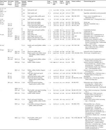
Hierarchical cluster analysis using PRIMER v.6 showed images clustering by substratum type (Figure 2a) and within a substratum category, by temperature/water mass (Figure 2b,c). Eighteen major clusters were identified at the 1% similarity level breaking the dataset into a more manageable size. Each of these major clusters were further analysed for the presence of sub-clusters reflective of coherent benthic assemblages at higher levels of similarity. A further 27 sub-clusters were identified through this analysis (Table 2). Those clusters containing less than 10 images (clusters A–E, G–H, J, M and sub-clusters OC, RA, RC, and RHB) were considered outliers and/or not representative of coherent benthic assemblages, and were not considered further. Clusters OA and OD contained exactly 10 images each but were characterized by poorly taxonomically resolved species. Following analysis of the video associated with the images belonging to these clusters neither were thought to represent distinct biological assemblages and were therefore not considered further. Cluster N was characterized by Mysids, which are a benthopelagic, mobile species. This cluster was not considered a coherent benthic assemblage and was therefore also not considered further.
Hierarchical cluster analysis of species sample data: (A) all data; (B) sand–mud and coral substrates; (C) mixed to bedrock substrates. Major clusters have been collapsed for display purposes.

Clusters identified from quantitative analysis of image data, distribution, characterizing species and associated environmental parameters are indicated for each cluster.

In total 26 benthic assemblages were identified from cluster analysis that could be distinguished in the associated video and existed on a scale appropriate to broadscale mapping efforts (Table 2; Figure 3). Five of these assemblages were unique to the canyon feature and one was unique to the ridge feature (Table 2). No assemblages were unique to the seamount, bank or continental slope features. Three assemblages were restricted to the cold waters of the Faroe–Shetland Channel, occurring on the continental slope and/or on the north side of the Wyville-Thomson Ridge. Sixteen were restricted to the warm waters of the Rockall Trough and upper warm water masses of the Faroe–Shetland Channel. One assemblage was restricted to the warm waters of the Faroe–Shetland Channel, occurring on both the continental slope and Wyville-Thomson Ridge. Six assemblages were found over the full range of temperatures sampled. For these six assemblages it is likely that poor taxonomic resolution of the characterizing species masks differences in assemblage composition between cold and warm water masses.
Example representative images of the 26 assemblages identified from hierarchical cluster analysis.

In order for the 26 biological assemblages identified here to be easily slotted into existing classification schemes it is essential that they can be attributed to a single broad substratum category of the type used in existing classification schemes. RHE occurred on multiple substratum ‘types’ and was therefore further subdivided to aid its application to mapping efforts. In addition some assemblages identified here (PBC, RBB, RHE and RHF) mix well described biological communities (e.g. cold water coral reefs) with other assemblages containing similar key species (e.g. other assemblages containing isolated or small Lophelia pertusa colonies). The resolution of such assemblages is not sufficient for management efforts, and further division is required to identify these distinct communities as separate to the rest of the assemblage. In the case of the Lophelia pertusa reef this is necessary given the legal status and perceived conservation value of cold water coral reef communities.
DISCUSSION
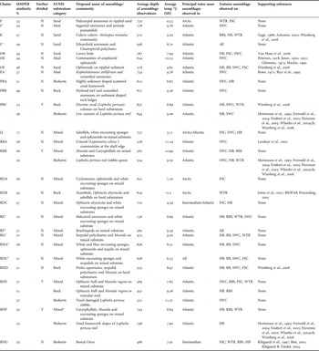
After further subdivision of those clusters identified above, 31 assemblages and their associated environmental parameters or ‘biotopes’ (sensu Connor et al., Reference Connor, Allen, Golding, Howell, Lieberknecht, Northen and Reker2004) were described (Table 3) from quantitative analysis of 1987 images from 139 video transects sampled from the upper bathyal zone (200–1000 m) of the north-east Atlantic. Full descriptions and morphospecies lists are provided in an Appendix to this paper. The described ‘biotopes’ (sensu Connor et al., Reference Connor, Allen, Golding, Howell, Lieberknecht, Northen and Reker2004) provide easily recognizable consistent ‘units’ on which mapping efforts can be based. However, in order for these biotope units to be useful, in terms of marine environmental management and MPA network design, the biological mapping ‘units’ need to be incorporated into a hierarchical classification system.
Final assemblages defined from analysis and further subjective division of clusters to aid in practical use and incorporation to existing classification schemes.

* Some uncertainty as to the validity of these biotopes, see text for details.
Nearly all existing habitat classification systems categorize the habitat according to substratum at their lowest levels (Allee et al., Reference Allee, Dethier, Brown, Deegan, Ford, Hourigan, Maragos, Schoch, Sealy, Twilley, Weinstein and Yoklavich2001; Roff & Taylor, Reference Roff and Taylor2000, Connor et al., Reference Connor, Allen, Golding, Howell, Lieberknecht, Northen and Reker2004; Davies et al., Reference Davies, Moss and Hill2004). As this project was undertaken in European waters the European Habitat Classification System EUNIS (Davies et al., Reference Davies, Moss and Hill2004) has been used as a template for the broad substratum categories, into which assemblages could be slotted. However, it should be noted that refinement of existing systems based on emerging ‘bottom-up’ information about patterns of biodiversity should be undertaken in preference to forcing new information into existing hierarchical structures. Within EUNIS the following substratum categories are recognized: deep-sea mud, deep-sea muddy sand, deep-sea sand, deep-sea mixed substrata, deep-sea rock and deep-sea bioherms. The 31 assemblages described here have been assigned to the most appropriate of the existing EUNIS substratum categories (Table 3). The category deep-sea muddy sand has not been used as it was not possible to consistently distinguish this category using video/image data. The following discussion has been structured around these broad substratum categories. Each of the assemblages described above is, where possible, compared with assemblages described in the literature. The comparison is based on the presence of the characterizing species and, where available, descriptions of the broad environmental parameters (e.g. depth and substratum type).
Deep-sea mud and sand assemblages
Eight of the described assemblages could be designated sand or mud assemblages (Table 3). Five could be supported by reference to the peer reviewed literature.
The assemblage described by cluster F was essentially limited to the cold waters of the FSC and was associated with a specific geomorphological feature (unpublished data). Although this assemblage has not been described previously, video observations suggest it is a distinct assemblage that merits recognition.
Cluster I was restricted to the Canyon feature and it is assessed below together with other canyon-restricted assemblages.
The assemblage described by cluster K is broadly comparable to an assemblage described by Gage (Reference Gage1986) from this region. Gage (Reference Gage1986) identified two assemblages in the bathymetric zone ranging from 200–700 m in the Rockall Trough from trawl samples. One of these assemblages is situated on sandy deposits. Within this assemblage megafauna is sparse but the echinoderm species Cidaris cidaris, Spatangus raschi and Stichopus tremulus are relatively abundant within trawl samples (Gage, Reference Gage1986). Gage also notes the occurrence of these species from the continental shelf in the North Sea, around the Shetlands, in the Norwegian Trench, on Porcupine Bank and the summit of Anton Dohrn Seamount, Rockall Plateaux and other banks to the north (Sussbach & Breckner, Reference Sussbach and Breckner1911; Pawsey & Davis, Reference Pawsey and Davis1924; Dyer et al., Reference Dyer, Fry, Fry and Cranmer1982; Cranmer, Reference Cranmer1985). More recently Axlesson (2003) found that the sandy sediments of the UK continental slope were dominated by irregular echinoids (possibly Spatangus purpureus) and the holothurian Stichopus tremulus. Wienberg et al. (Reference Wienberg, Beuck, Heidkamp, Hebbeln, Freiwald, Pfannkuche and Monteys2008), in their description of the faunal assemblage on the soft sediments near the Franken Mound at 650 m on Rockall Bank, noted Cidaris cidaris as the most common species, as well as asteroids, holothurians, cerianthids and Bolocera tuediae. Observations from the video associated with those images belonging to cluster K, together with video observations from the seamounts and banks of the Rockall Trough in general, suggest that cluster K represents a distinct assemblage occurring on sandy substrata throughout the Rockall Trough.
The assemblage termed cluster L has not been described previously from the deep-sea. This assemblage is characterized by Edwardsiid anemones (Edwardsiidae msp. 1) and polychaetes (Chaetopteridae msp. 1). Observation of the video associated with the images belonging to this cluster, reveals that Chaetopterids are not useful as a distinguishing species. The assemblage is difficult to distinguish visually from that of cluster K as the Edwardsiid anemones are difficult to see when the camera is elevated. It is however distinguishable by the greatly reduced abundance of, and in some areas absence of, Stichopus tremulus. Quantitative analysis of video data would provide a more detailed description of this assemblage.
The assemblage described by cluster OB has not been described previously from the deep-sea, but is well known to occur in both littoral and subtidal shelf regions (Van Hoey et al., Reference Van Hoey, Guilini, Rabaut, Vincx and Degraer2008). The assemblage is characterized by dense aggregations of a species that has been provisionally identified as the sand mason worm, Lanice conchilega. Although we cannot be certain the species observed in this study is L. conchilega as no physical samples were taken, this species is known to occur to depths of 1900 m (Hartmann-Schröder, Reference Hartmann-Schröder1996) making it at least possible. Assemblages of sand mason worms can reach densities of several thousand individuals per square metre (Van Hoey et al., 2008), in sediments ranging from mud to coarse sand (Van-Hoey et al., 2008). Their distribution is primarily determined by sedimentology (Willems et al., Reference Willems, Goethals, Van den Eynde, Van Hoey, Van Lancker, Verfaillie, Vincx and Degraer2008), however hydrology and food supply have also been correlated with the occurrence of the densest aggregations (Van Hoey et al., Reference Van Hoey, Guilini, Rabaut, Vincx and Degraer2008). Lanice conchilega is regarded as a habitat structuring species as its presence in high densities affects the surrounding benthic assemblage. Both density and species richness of benthos increase with increasing density of L. conchilega up to a critical density (500–1000 ind/m2) (Van Hoey et al., Reference Van Hoey, Guilini, Rabaut, Vincx and Degraer2008). The habitat structuring properties of these aggregations and their wide recognition in the literature suggest this can be regarded as a distinct assemblage within the deep-sea.
Wienberg et al. (Reference Wienberg, Beuck, Heidkamp, Hebbeln, Freiwald, Pfannkuche and Monteys2008) note in areas of rippled seabed, high abundances of ophiuroids. In the present study cluster OF is characterized by ophiuroids and is present over a similar temperature and depth range to cluster K. Observations from the video associated with those images belonging to cluster OF also identify this assemblage as being associated with rippled seabed. Video observations from the banks and seamounts of the Rockall Trough suggest that this is a distinct assemblage that occurs on rippled sand seabed throughout the Rockall Trough.
The assemblages described by clusters I, OE and PA were all limited to the SW Canyons (if outliers are omitted). Descriptions of the megafaunal assemblages of canyons are lacking despite numerous publications dealing with the subject (Rowe, Reference Rowe1971; Headrich et al., Reference Headrich, Rowe and Polloni1975; Hecker et al., Reference Hecker, Logan, Gandarillas and Gibson1988; Cartes et al., Reference Cartes, Company and Maynou1994; Sarda et al., Reference Sarda, Cartes and Company1994; Vetter & Dayton, Reference Vetter and Dayton1999; Duineveld et al., Reference Duineveld, Lavaleye, Berghuis and De Wilde2001; Schlacher et al., Reference Schlacher, Schlacher-Hoenlinger, Williams, Althaus, Hooper and Kloser2007) making comparison impossible.
Cluster I was characterized by anemones (tentatively identified as belonging to the family Sagartiidae) and unidentified juvenile pennatulids. This assemblage has not been described previously in the literature. Analysis of the video associated with images belonging to this cluster suggests this assemblage is found in close proximity, and in some cases is difficult to distinguish from that assemblage described by cluster PA. It is possible that this cluster may not represent a distinct assemblage at all, rather an artefact of the sampling method used. However, quantitative analysis of video data would be required to test this.
Cluster OE was characterized by amphiurid ophiuroids. Existing assemblages within EUNIS characterized by members of this group include: (1) Amphiura filiformis, Mysella bidentata and Abra nitida in circalittoral sandy mud (A5.351); (2) Amphiura filiformis and Nuculoma tenuis in circalittoral and offshore muddy sand (A5.353); and (3) Brissopsis lyrifera and Amphiura chiajei in circalittoral mud (A5.363). (1) and (2) are considered part of the Amphiura filiformis dominated circalittoral etage described by Glémarec (Reference Glémarec1973) and the ‘off-shore muddy sand association’ described by other workers (Jones, Reference Jones1951; Mackie, Reference Mackie1990). Whereas (3) is considered part of the 'Boreal Offshore Mud Association' and ‘[Brissopsis–Chiajei]’ assemblages described by other workers (Petersen, Reference Petersen1918; Jones, Reference Jones1950). Cluster OE could be considered a deep-water extension of one (or more) of these existing assemblages. However, lack of infaunal data does not allow an assessment of whether the assemblage described by cluster OE is one of these assemblages listed or a new deep-sea variant.
The assemblage described by cluster PA is similar to an existing assemblage within EUNIS, Sea pens and burrowing megafauna in circalittoral fine mud (A5.36). A5.36 is characterized by the sea pens Virgularia mirabilis and Pennatula phosphorea together with the burrowing anemone Cerianthus lloydii and the ophiuroid Amphiura spp. Cluster PA is also characterized by sea pens and cerianthid anemones although not those listed in A5.36. ‘Lifetraces’ indicative of burrowing megafauna were also observed from images belonging to this cluster, however these were not quantified or included in the analysis. PA could be considered a deep-water version of A5.36. The characterizing species, the sea pen Kophobelemnon stelliferum, is widely distributed along the continental slopes of the northern Atlantic and Pacific Oceans at depths from 400 m to 2500 m although it has been reported from 40 m in Norwegian waters (Rice et al., Reference Rice, Tyler and Paterson1992). Photographic observations of this species from the Hatteras Canyon in the north-western Atlantic suggest it can be locally abundant reaching densities of up to 12 m2 (Rowe, Reference Rowe1971). Photographic studies in the Porcupine Seabight suggest rather lower densities of 2.6 m2 (Rice et al., Reference Rice, Tyler and Paterson1992). Visual inspection of the images published in Rice et al. (Reference Rice, Tyler and Paterson1992) suggests that the assemblage described by cluster PA is not limited to canyon systems. Its absence from other areas surveyed within this study is most likely a reflection of the lack of comparable substratum sampled, with this assemblage being found on fine mud or sandy mud substrate.
Deep-sea mixed substratum assemblages
Twelve of the described assemblages could be considered as occurring on mixed substrates (gravel–cobble) (Table 3). One assemblage could be supported by reference to the peer reviewed literature (RBA). Of the remaining assemblages 3 (RHE, RHF and RBB), were further subdivided on the basis of broad substrate type and/or separation of cold-water coral reef communities from similar non-reef associated communities, for use in a classification system (Table 3). Clusters RBB and RHF contained examples of an assemblage associated with cold water coral reefs communities. These sub-assemblages are supported in the literature and are discussed under ‘Bioherms’. The non-coral reef examples of RHF were few, however video observations suggest it may be an identifiable community of use in classification and mapping. The non-coral reef examples of RBB were more numerous and justification of this assemblage as a distinct entity is clearer than for RHF. The assemblage defined by cluster RHE occurred on three broad substratum types, one of which was associated with a region of trawl damaged cold water coral reef (now rubble) (see below). However, this assemblage was primarily observed on mixed substrate. Video observations suggest this is a distinct community that is easily identified although no supporting descriptions of such a community could be found in the literature.
The assemblage described by cluster RBA is similar to an assemblage described by Lavaleye et al. (Reference Lavaleye, Duineveld, Berghuis and Witbaard2002) from this region. These authors describe a shelf edge station on Goban Spur at 200 m as dominated by Leptometra celtica and a comparable station at 190 m on the Iberian margin as dominated by crinoids. These authors attribute the high densities of these organisms at the shelf-break to the occurrence of rich concentrations of suspended organic particles. This assemblage was only observed from the SW Canyons and was present at the heads of the canyons (Davies, unpublished data). Observations from the video associated with the images from cluster RBA suggest this assemblage occurs in areas of strong current flow.
Clusters Q and RDA were essentially limited to the cold waters of the FSC. No descriptions of epibenthic mixed sediment assemblages could be found in the literature, for comparison. Similarly the assemblages described by clusters RDC, RE, RF, RG, RHA and RHC could not be compared to the assemblages described. Visually it is difficult to distinguish between those images belonging to clusters RE, RF, RG, RHA and RHC. Further analysis of the spatial distributions and geomorphological associations of these clusters may reveal important differences between these assemblages, supporting their identification and description. However, in practical terms it may be impossible to tell these assemblages apart through visual survey.
Deep-sea rock assemblages
Five of the described assemblages could be considered as occurring on hard substrates (Table 3). Three assemblages could be supported by reference to the literature (PBC, RDB and RHD). One (RHE) was primarily observed on mixed substrates and is discussed under that heading. While the final (PBB) was restricted to canyon features.
The assemblage described by cluster PBB is interesting in that it could also be considered a sand–mud substratum assemblage. This assemblage was associated with bedrock ledges or outcrop, in-filled or covered with a veneer of fine sediment. It is therefore characterized by a hydroid turf (attached to the rock outcrop) and cerianthid anemones (Cerianthidae msp. 1) burrowed into the soft sediment areas. Although this assemblage has not been described previously, observation from the video associated with the images within cluster PBB reveals an easily identified distinct assemblage.
The assemblage described by cluster PBC included all images with live Lophelia pertusa. Lophelia pertusa has a cosmopolitan distribution but has been found most frequently in the north-esatern Atlantic. It is known to tolerate temperatures between 4 and 13°C (Freiwald, Reference Freiwald, Wefer, Billett, Hebbein, Jorgensen, Schluter and Van Weering2002), and is found from 39–3383 m. It can be found growing as isolated colonies, as well as forming bush-like clumps and reef like framework structures. Cluster PBC included examples of images from live sections of biogenic reef as well as growths of small colonies on rock outcrop, and boulders and cobble dropstones. The division of this assemblage into communities of cold water coral reefs and ‘other assemblages characterized by Lophelia pertusa’ is discussed more fully under Bioherms. However, clearly it is useful and ecologically meaningful to distinguish between areas of cold water coral reef framework (bioherms) and discrete colonies of L. pertusa. Wienberg et al. (Reference Wienberg, Beuck, Heidkamp, Hebbeln, Freiwald, Pfannkuche and Monteys2008) made this distinction in their descriptive paper defining coral assemblages associated with hard ground ridges separately to coral reef assemblages. They describe discrete colonies of octocorals, antipatherian and few Lophelia; up to 1–2 m diameter, accompanied by sponges, hydroids, actinians, crustaceans, echinoderms and fish.
The assemblage described by cluster RDB was limited to the cold waters of the FSC and specifically the base of the Wyville-Thomson Ridge. Although no description is available observations of images taken as part of the BIOFAR project (BIOFAR Proceeding, 2005) and other photographic studies of the base of the FSC (Jones et al., Reference Jones, Bett and Tyler2007) suggest this assemblage is present in other parts of the FSC and is easily recognizable. Further subdivision of this cluster may be possible and desirable as more data become available, particularly with regard to the spatial distribution of this assemblage and associations with geomorphological features. Video observations suggest there may be three distinct assemblages within this cluster that are associated with slope and water current strength. However, quantitative analysis of video data is required.
The assemblage described by cluster RHD is similar to hard ground assemblages described previously from the Rockall Trough. Wienberg et al. (Reference Wienberg, Beuck, Heidkamp, Hebbeln, Freiwald, Pfannkuche and Monteys2008) describe gravel to boulder sized debris colonized by serpulids, bryozoans, Psolus sp., Pliobothrus symmetricus and Stylaster, Phelliactis sp., octocorals, sponges, Munida sp., Paramola sp., Pagarus sp. and fish. Although the description of this cluster is somewhat more limited in the list of species that characterize this assemblage, video observations associated with the images belonging to this cluster, suggest these are the same assemblages.
Bioherms
COLD-WATER CORAL ASSEMBLAGES
In this study five assemblages were identified that were associated with cold-water coral reefs and/or reef-building corals (PBA, PBC, RBB, RHF and RHE). Cold water coral mounds (frameworks and bioherms) are widely recognized as a distinct biological community. These structures are generally divided in three ‘zones’ based largely on the condition of the coral (mostly living summit regions, mostly dead slope regions, and coral rubble apron) (Mortensen et al., Reference Mortensen, Hovland, Brattegard and Farestveit1995; Foubert et al., Reference Foubert, Beck, Wheeler, Opderbecke, Grehan, Klages, Thiede, Henriet, Freiwald and Roberts2005; Huvenne et al., Reference Huvenne, Beyer, de Haas, Dekindt, Henriet, Kozachenko, Olu-Le Roy, Wheeler, Freiwald and Roberts2005; Wheeler et al., Reference Wheeler, Beck, Thiede, Klages, Grehan, Monteys, Freiwald and Roberts2005a,Reference Wheeler, Bett, Billett, Masson, Mayor, Barnes and Thomasb; Wienberg et al., Reference Wienberg, Beuck, Heidkamp, Hebbeln, Freiwald, Pfannkuche and Monteys2008). The biological assemblages (clusters) identified here corresponded well to these zones and are discussed in that context.
MOSTLY LIVING SUMMIT REGIONS
Cluster PBC included examples of the live summit regions of cold-water coral reef, as well as dense L. pertusa clumps growing on exposed basalt, right down to small colonies growing on isolated dropstones. The biological assemblage of the live sections of a cold-water coral reef framework is ecologically distinct from the biological assemblages associated with small colonies of L. pertusa on hard substrate. The coral framework, on which the live coral assemblage sits, provides a habitat for hundreds if not thousands of species (Freiwald et al., Reference Freiwald, Fossa, Grehan, Koslow and Roberts2004). The summit region itself however, supports few permanently attached organisms as living corals are very successful in preventing fouling. Among those species that are permanently attached are the polychaete Eunice norvegica, the parasitic foraminiferan Hyrrokkin sarcophagi, and clusters of bivalves including Delectopecten vitreus and Acesta excavata (Freiwald et al., Reference Freiwald, Fossa, Grehan, Koslow and Roberts2004).
MOSTLY DEAD SLOPE REGIONS
Cluster RHF describes the assemblages of the mostly dead slope regions of cold water coral mound assemblages as well as other regions of accumulated dead L. pertusa, for example around the base of a basalt rock outcrop, or the base of a large boulder with L. pertusa colonies growing it. Freiwald et al. (Reference Freiwald, Fossa, Grehan, Koslow and Roberts2004) list those species occurring within this zone. Amongst the megafauna, gorgonians, actinians and sponges are conspicuous and abundant, while on smaller scale hydrozoans, bivalves, brachiopods, bryozoans and barnacles are prevalent (Freiwald et al., Reference Freiwald, Fossa, Grehan, Koslow and Roberts2004). Observations of the video associated with the images from cluster RHF confirm the actinians (Phelliactis sp.) and sponges as conspicuous and abundant megafauna, however these large bodied species are infrequently captured by the image samples and thus do not appear as characterizing species of this assemblage. Further description of this assemblage from quantitative analysis of video data is required.
CORAL RUBBLE APRON
Cluster RBB includes examples from the rubble apron ‘zone’ of cold water coral mounds as well as other mixed sediment substrates which provide a similar ‘habitat’ to the rubble apron ‘zone’. Mortensen et al. (Reference Mortensen, Hovland, Brattegard and Farestveit1995) identified high abundances of the squat lobster, Munida sarsi from this ‘zone’, which is consistent with the characterizing species of this cluster. Freiwald et al. (Reference Freiwald, Fossa, Grehan, Koslow and Roberts2004) also list encrusting sponges and echiurid worms as common to this zone. Observations from the video associated with the images from cluster RBB confirm the presence of the echiuran Bonellia viridis in this assemblage.
MODIFIED COLD-WATER CORAL COMMUNITIES
Clusters PBA and RHE appear to represent modified versions of described communities associated with cold water coral reefs. In regions where the broken reef framework (dead slope zone and to an extent the rubble apron zone) has become heavily draped in sediment the community composition understandably changes. Species such as cerianthid anemones become dominant. Cluster PBA appears to represent such an assemblage and is comparable to an assemblage described by Wheeler et al. (Reference Wheeler, Beyer, Freiwald, De Haas, Huvenne, Kozachenko, Olu-Le Roy and Opderbecke2007): ‘Sediment-clogged coral framework facies’. This cluster was primarily observed in the canyons where heavy sedimentation of coral frameworks was observed (J. Davies, University of Plymouth, unpublished data). Similarly cluster RHE contained examples of images from coral mounds that had been damaged by trawling activity (J. Guinan, Marine Institute Galway, unpublished data). Although the species composition of these regions was similar to that of other mixed sediments, and as the characterizing species go, similar to the rubble apron zone of intact cold-water coral mounds, it may be desirable to identify this assemblage as distinct from non-coral assemblages for the purposes of environmental management.
DEEP-SEA SPONGE AGGREGATIONS
Cluster RHG primarily describes sponge-rich assemblages in the Faroe–Shetland Channel with outlying observations from the Wyville-Thomson Ridge, Rosemary Bank and Hatton Bank, most likely a result of the use of morphospecies for sponge identification. Observation of video data associated with the images from this cluster reveals a rich sponge fauna, including large raised sponge-covered structures and massive sponge forms. This assemblage was centred on the 500 m contour in a region where temperature was observed to fluctuate from below 0 to more than 7°C. Sponge assemblages are well known to occur in the Faroe–Shetland Channel (Klitgaard et al., Reference Klitgaard, Tendal, Westerberg, Hawkins and Hutchins1997; Bett, Reference Bett2001) as well as further north in the Norwegian Sea, Greenland Sea, western Barents Sea, Reykjanes Ridge and Denmark Strait (for a full review see Klitgaard & Tendal, Reference Klitgaard and Tendal2004). The assemblages or ostur have been classified by Klitgaard & Tendal (Reference Klitgaard and Tendal2004) into two types: a boreal ostur dominated by Geodia barretti, Geodia macandrewi, Geodia atlantica, Isops phlegraei, Stryphnus ponderosus and Stelletta normani and a cold water ostur characterized by the same genera but represented by different species. Boreal ostur occur around the Faroe Islands, Norway, Sweden, parts of the Western Barents Sea and south of Iceland; while cold water ostur occur north of Iceland, in the Denmark Strait, off east Greenland and north of Spitzbergen. It is likely that the ostur observed here are of the boreal type.
CONCLUSIONS
This study represents one of the first attempts to systematically define assemblages of deep-sea organisms and their associated environmental parameters (biotopes) for the purposes of biological (habitat) mapping and providing fine-scale surrogates for representing biological diversity in marine environmental management and MPA network design. Thirty-one benthic assemblages and their associated environmental parameters, ‘biotopes’, have been identified from the broad geographical region of the Rockall Trough and Faroe–Shetland Channel (Table 3). Supporting descriptions of 14 of these assemblages were uncovered in the existing literature.
The 31 assemblages defined here provide consistent units for use in biological (habitat) mapping efforts and assessments of representativeness in MPA network design. It should be noted that these are preliminary descriptions based on analysis of image data. It is anticipated that these descriptions will evolve as more data from a wider area and from different sampling tools become available over time. Ideally the biological assemblages defined here should be incorporated into a hierarchical classification system. However, few existing classification systems, which are applicable to the deep-sea (Greene et al., Reference Greene, Yoklavich, Starr, O'Connell, Wakefield, Sullivan, McRea and Cailliet1999; Allee et al., Reference Allee, Dethier, Brown, Deegan, Ford, Hourigan, Maragos, Schoch, Sealy, Twilley, Weinstein and Yoklavich2001; Roff & Taylor, Reference Roff and Taylor2000; Butler et al., Reference Butler, Harris, Lyne, Heap, Passlow and Smith2001; Davies et al., Reference Davies, Moss and Hill2004; Madden et al., Reference Madden, Goodin, Allee, Finkbeiner and Bamford2008), incorporate units at the biological assemblage level. One important exception, which is most relevant to the region that is the focus of this study, is the European Habitat Classification System (EUNIS) (Davies & Moss, Reference Davies and Moss1999; Davies et al., Reference Davies, Moss and Hill2004). This system already includes units at the biotope level some of which are consistent with the assemblages identified by this study (e.g. EUNIS A6.611: Deep-sea [Lophelia pertusa] reefs). The assemblages described here could be easily incorporated into that system dramatically improving its usefulness at fine-scale resolution.
ACKNOWLEDGEMENTS
The authors would like to acknowledge with thanks the scientists, officers and crew of RV ‘Celtic Explorer’ and MV ‘Franklin’, the staff at Geotek and Marin Mätteknik AB, and Dr David Hughes. We are also grateful for identifications provided by L. Allcock, C. Wood, P. Tyler, J. Gordon, F. Neat, E. Le Guilloux, G. Wigham and B. Wigham; and to Professor John Spicer for helpful comments on the manuscript. The project and the collection of data used within was funded by the Joint Nature Conservation Committee; the INTERREG IIIB NWE Programme through the Mapping European Seabed Habitats project; the Department for Business, Enterprise and Regulatory Reform through Strategic Environmental Assessment 7; the Department for Environment, Food and Rural Affairs through the offshore Special Areas for Conservation programme; and a joint Research Councils of the UK fellowship awarded to K.L. Howell.
Appendix. Descriptions of final biotopes with full morphospecies lists for each
Deep-sea mud and sand assemblages
Halcampid anemones in rippled sand—Cluster F
This cluster contained 27 images. Analysis of this cluster using the SIMPER routine in PRIMER 6 (Clarke & Warwick, Reference Clarke and Warwick2001) revealed the average similarity within this group to be 33.07%. SIMPER analysis identified this assemblage as characterized by anemones belonging to the family Halcampoididae (Halcampoididae msp. 5). Analysis of the environmental parameters associated with this assemblage suggests it is found on sand and gravely sand substrate, at temperatures between –1 and 7.7°C (mean 0.33°C SD 1.89°C) and at depths of 518–809 m (mean 732 m SD 107 m). This assemblage was primarily observed in the Fare–Shetland Channel, with single outlying observations from the South-West Canyons and Hatton Bank.

Sagartiid anemones and juvenile pennatulids—Cluster I
This cluster contained 25 images. Analysis of this cluster using the SIMPER routine in PRIMER 6 (Clarke & Warwick, Reference Clarke and Warwick2001) revealed the average similarity within this group to be 23.91%. SIMPER analysis identified this assemblage as characterized by anemones belonging to the family Sagartiidae and unidentified juvenile pennatulids. Analysis of the environmental parameters associated with this assemblage suggests it is found on mud and muddy sand substrate, at temperatures between 8 and 11°C (mean 9.76°C SD 0.43°C), and at depths of 465–928 m (mean 778 m SD 102 m). This assemblage was restricted to the South-West Canyons.

Cidaris cidaris–Stichopus tremulus community—Cluster K
This cluster contained 23 images. Analysis of this cluster using the SIMPER routine in PRIMER 6 (Clarke & Warwick, Reference Clarke and Warwick2001) revealed the average similarity within this group to be 26.53%. SIMPER analysis identified this assemblage as characterized by urchins (Cidaris cidaris), cup corals (Caryophyllia msp. 3) and unidentified ophuroids (Ophiuroidea msp. 5). Analysis of the environmental parameters associated with this assemblage suggests it is found on sand and mixed cobble, pebble, gravel–sand substrates, at temperatures between 8 and 11°C (mean 9.20°C SD 0.35°C), and at depths of 419–852 m (mean 510 m SD 99 m). This assemblage was observed on Rosemary Bank Seamount, Hatton Bank and the shallow summit of the Wyville-Thomson Ridge.

Edwardsiid anemones and Chaetopterid polychaetes—Cluster L
This cluster contained 36 images. Analysis of this cluster using the SIMPER routine in PRIMER 6 (Clarke & Warwick, Reference Clarke and Warwick2001) revealed the average similarity within this group to be 28.80%. SIMPER analysis identified this assemblage as characterized by edwardsiid anemones (Edwardsiidae msp. 1) and polychaetes (Chaetopteridae msp. 1). Analysis of the environmental parameters associated with this assemblage suggests it is found on sand and mixed substrates of sand–pebble and cobble, at temperatures between 1 and 12°C (mean 8.70°C SD 1.62°C), and at depths of 212–899 m (mean 598 m SD 151 m). This assemblage was observed in the South-West Canyons, on Hatton Bank, Rosemary Bank Seamount, and the warm shallow regions of the Wyville-Thomson Ridge and Faroe–Shetland Channel.

Lanice beds—Cluster OB
This cluster contained 58 images. Analysis of this cluster using the SIMPER routine in PRIMER 6 (Clarke & Warwick, Reference Clarke and Warwick2001) revealed the average similarity within this group to be 39.36%. SIMPER analysis identified this assemblage as characterized by tube worms (Lanice cf.) at an average density of 12 tubes per m2. Analysis of the environmental parameters associated with this assemblage suggests it is associated with coarse sand and mixed sand, gravel (including biogenic gravel), and pebble substrates, primarily at temperatures of 7–12°C (single observation at –1°C) (mean 7.94°C SD 1.42°C), and depths of 290–951 m (mean 787 m SD 175 m). This assemblage was primarily observed on Hatton Bank, with a single observation from the South-West Canyons and one from the Faroe–Shetland Channel.

Communities of amphiurid ophiuroids—Cluster OE
This cluster contained 87 images. Analysis of this cluster using the SIMPER routine in PRIMER 6 (Clarke & Warwick, Reference Clarke and Warwick2001) revealed the average similarity within this group to be 44.30%. SIMPER analysis identified this assemblage as characterized by burrowing ophiuroids (Amphiuridae). Analysis of the environmental parameters associated with this assemblage suggests it is associated with fine mud and sand substrates that occasionally may also have with a small percentage of gravel and pebbles, at temperatures of 7–12°C (mean 10.33°C SD 0.88°C), and depths of 252–1008 m (mean 624 m SD 224 m). This assemblage was only observed in the South-West Canyons.

Ophiuroids on rippled sediment—Cluster OF
This cluster contained 378 images. Analysis of this cluster using the SIMPER routine in PRIMER 6 (Clarke & Warwick, Reference Clarke and Warwick2001) revealed the average similarity within this group to be 47.99%. SIMPER analysis identified this assemblage as characterized by ophiuroids (Ophiuroidea msp. 1). Analysis of the environmental parameters associated with this assemblage suggests it is associated with sand and mud substrates that may also have with a small percentage of gravel and pebbles, at temperatures of −1 to 12°C (mean 9.82°C SD 1.83°C), and depths of 205–1021 m (mean 578 m SD 238 m). This assemblage was primarily observed in the South-West Canyons, on Hatton Bank and Rosemary Bank Seamount, with only 5 observations from the Faroe–Shetland Channel.

Kophobelemnon stelliferum and cerianthid anemones—Cluster PA
This cluster contained 97 images. Analysis of this cluster using the SIMPER routine in PRIMER 6 (Clarke & Warwick, Reference Clarke and Warwick2001) revealed the average similarity within this group to be 37.05%. SIMPER analysis identified this assemblage as characterised by cerianthid anemones (Cerianthidae msp. 1) and the sea pen Kophobelemnon msp. Analysis of the environmental parameters associated with this assemblage suggests it is associated with fine mud and muddy-sand substrates that occasionally may also have a small percentage of gravel and pebbles, at temperatures of 7–12°C (mean 9.78°C SD 0.76°C), and depths of 242–1059 m (mean 734 m SD 201 m). This assemblage was primarily observed in the South-West Canyons, with limited observations from Hatton Bank, Rosemary Bank Seamount and the Wyville-Thomson Ridges (8 in total). Reanalysis of the images in this cluster suggests that poor taxonomic resolution of the cerianthid anemones is likely to have lead to the clustering of these 8 images with this assemblage type.

Deep-sea mixed substratum assemblages
Sabellids, white encrusting sponges and ophiuroids on mixed substrate—Cluster Q
This cluster contained 105 images. Analysis of this cluster using the SIMPER routine in PRIMER 6 (Clarke & Warwick, Reference Clarke and Warwick2001) revealed the average similarity within this group to be 16.67%. SIMPER analysis identified this assemblage as characterized by polychaetes of the family Sabellidae (msp. 1 and msp. 2), unidentified polychaetes (Polychaete msp. 6), unidentified ophiuroids (Ophiuroidea msp. 4) and white encrusting sponges (Porifera encrusting msp. 1). Analysis of the environmental parameters associated with this assemblage suggests it is found on muddy-sand and mixed pebbles, cobbles and sand, over the range of temperatures sampled (sub-zero to 12°C; mean 3.11°C SD 4.80°C), and over the range of depths sampled (111–1027 m) (mean 737 m SD 190 m). This assemblage was primarily observed in the cold waters of the Faroe–Shetland Channel, however it was also observed in the South-West Canyons and on Hatton Bank. The poor taxonomic resolution of some of the characterizing species likely masks genuine differences in benthic assemblages, particularly from cold and warmer waters. However, physical sampling would be required to confirm this.

Crinoid (Leptometra celtica) communities at the shelf edge—Cluster RBA
This cluster contained 18 images. Analysis of this cluster using the SIMPER routine in PRIMER 6 (Clarke & Warwick, Reference Clarke and Warwick2001) revealed the average similarity within this group to be 26.78%. SIMPER analysis identified this assemblage as characterized by Crinoids (Leptometra celtica and Crinoidea msp. 5). Analysis of the environmental parameters associated with this assemblage suggest it is found on mixed sediments of sand and pebbles–shells, at temperatures between 9 and 12°C (mean 11.19°C SD 0.48°C), and at depths of 190–699 m (mean 328 m SD 148 m). This assemblage was observed in the South-West Canyons only.

Cluster RBB contained 52 images. Analysis of this cluster using the SIMPER routine in PRIMER 6 (Clarke & Warwick, Reference Clarke and Warwick2001) revealed the average similarity within this group to be 26.60%. In order to recognize the biological distinctness of cold water coral reef rubble communities and other mixed substrate communities of similar megafaunal composition this assemblage was divided, post analysis, into two distinct biotopes. The mixed substrate biotope is described below and the coral reef associated biotope is described under ‘Bioherms’.
Munida and Caryophyllids on mixed substrates—RBB mixed
This grouping contained 33 images. Analysis of this cluster using the SIMPER routine in PRIMER 6 (Clarke & Warwick, Reference Clarke and Warwick2001) revealed the average similarity within this group to be 26.32%. SIMPER analysis identified this assemblage as characterized by squat lobsters (Munida mspp.) and crinoids (Leptometra celtica). Analysis of the environmental parameters associated with this assemblage suggest it is found on mixed sediments of sand, pebbles and cobbles, at temperatures between 8 and 12°C (mean 11°C SD 0.83°C), and at depths of 185–825 m (mean 382 m SD 198 m). This assemblage was observed in the South-West Canyons, Hatton Bank, and Rosemary Bank Seamount.

Cyclostomes, ophiuroids and white encrusting sponges on mixed substrates—Cluster RDA
This cluster contained 15 images. Analysis of this cluster using the SIMPER routine in PRIMER 6 (Clarke & Warwick, Reference Clarke and Warwick2001) revealed the average similarity within this group to be 26.33%. SIMPER analysis identified this assemblage as characterized by ophiuroids (Ophiactis abyssicola), cyclostome bryozoans and white encrusting sponges (Porifera encrusting msp. 1). Analysis of the environmental parameters associated with this assemblage suggest it is found on mixed sediments of sand, gravel, pebbles, cobbles and boulders, at temperatures between –1 and 8°C (mean 1.1°C SD 2.75°C), and at depths of 549–820 m (mean 651 m SD 91 m). This assemblage primarily occurred in the cold waters of the Faroe–Shetland Channel; however two images within the cluster were from Hatton Bank. The images from Hatton Bank were outliers to the main body of the cluster and are most likely drawn into the cluster by the poor taxonomic resolution of one the characterizing species (white encrusting sponges).

Ophiactis abyssicola and white encrusting sponges on mixed substrates—Cluster RDC
This cluster contained 17 images. Analysis of this cluster using the SIMPER routine in PRIMER 6 (Clarke & Warwick, Reference Clarke and Warwick2001) revealed the average similarity within this group to be 37.38%. SIMPER analysis identified this assemblage as characterized by ophiuroids (Ophiactis abyssicola) and white encrusting sponges (Porifera encrusting msp. 1). Analysis of the environmental parameters associated with this assemblage suggest it is found on coarse sediments of pebbles, cobbles and boulders and coral, at temperatures between –1 and 8°C (mean 4.39°C SD 3.15°C), and at depths of 588–901 m (mean 710 m SD 136 m). This assemblage primarily occurred in the intermediate waters of the Faroe–Shetland Channel and on Hatton Bank. It is likely that poor taxonomic resolution of one of the characterizing species (white encrusting sponge) has lead to the formation of this cluster.

Halcampid anemones and white encrusting sponges on mixed substrate—Cluster RE
This cluster contained 43 images. Analysis of this cluster using the SIMPER routine in PRIMER 6 (Clarke & Warwick, Reference Clarke and Warwick2001) revealed the average similarity within this group to be 22.33%. SIMPER analysis identified this assemblage as characterized by anemones belonging to the family Halcampoididae (Halcampoididae msp. 3), an unidentified tube worm (Polychaeta msp. 4), and white encrusting sponges (Porifera encrusting msp. 1). Analysis of the environmental parameters associated with this assemblage suggest it is associated with mud, sand and mixed sediments of sand with gravel, pebbles and rarely cobbles, primarily at temperatures between 7 and 12°C (8.69°C SD 0.91°C), and at depths of 321–1006 m (mean 736 m SD 179 m). This assemblage was observed on Hatton Bank, Rosemary Bank, South-West Canyons and a single observation from the shallow summit of the Wyville-Thomson Ridge.

Brachiopods on mixed substrate—Cluster RF
This cluster contained 32 images. Analysis of this cluster using the SIMPER routine in PRIMER 6 (Clarke & Warwick, Reference Clarke and Warwick2001) revealed the average similarity within this group to be 51.02%. SIMPER analysis identified this assemblage as characterized by brachiopods (Brachiopoda). Analysis of the environmental parameters associated with this assemblage suggest it is associated with sand sediments with some degree of coarser material of gravel, pebbles and rarely cobbles size, primarily at temperatures between 7 and 12°C (9.39°C SD 0.72°C), and at depths of 266–803 m (mean 560 m SD 121 m). This assemblage was observed on Hatton Bank, Rosemary Bank, South-West Canyons and the warm shallow regions of the Wyville-Thomson Ridge and Faroe–Shetland Channel.

Serpulid polychaetes and Munida on mixed substrate—Cluster RG
This cluster contained 56 images. Analysis of this cluster using the SIMPER routine in PRIMER 6 (Clarke & Warwick, Reference Clarke and Warwick2001) revealed the average similarity within this group to be 26.64%. SIMPER analysis identified this assemblage as characterized by serpulid polychaetes (Serpulidae msp. 1), squat lobsters (Munida mspp.) and white encrusting sponge (Porifera encrusting msp. 1). Analysis of the environmental parameters associated with this assemblage suggest it is associated with sand sediments with some degree of coarser material of gravel (including biogenic gravel), pebbles and rarely cobble and boulder size, primarily at temperatures between 6 and 12°C (9.50°C SD 2.20°C), and at depths of 189–961 m (mean 475 m SD 208 m). This assemblage was observed on Hatton Bank, Rosemary Bank, South-West Canyons and the warm shallow regions of the Wyville-Thomson Ridge. A single image in this cluster was from the cold (–1°C) waters of the Faroe–Shetland Channel and was most likely drawn into this cluster as a result of the poor taxonomic resolution of one of the characterizing species (white encrusting sponges).

White and blue encrusting sponges, ophiuroids and majids on mixed substrate—Cluster RHA
This cluster contained 20 images. Analysis of this cluster using the SIMPER routine in PRIMER 6 (Clarke & Warwick, Reference Clarke and Warwick2001) revealed the average similarity within this group to be 27.80%. SIMPER analysis identified this assemblage as characterized by ophiuroids (Ophiuroidea msp. 6), white encrusting sponge (Porifera encrusting msp. 1), majid crabs (Majidae msp. 1), blue encrusting sponge (Porifera encrusting msp. 16), encrusting bryozoan (Bryozoa msp. 1), and brachiopods (Brachiopoda). Analysis of the environmental parameters associated with this assemblage suggest it is associated with mixed sediments of sand, gravel (including biogenic gravel), pebbles and cobbles, primarily at temperatures between 7 and 9°C (8.21°C SD 0.33°C), and at depths of 615–1015 m (mean 828 m sd 93 m). This assemblage was primarily observed on Hatton Bank and Rosemary Bank with a single observation from the deepest part of the South-West Canyons sampled (1015 m).

White encrusting sponges and serpulids on mixed substrate—Cluster RHC
This cluster contained 45 images. Analysis of this cluster using the SIMPER routine in PRIMER 6 (Clarke & Warwick, Reference Clarke and Warwick2001) revealed the average similarity within this group to be 27.03%. SIMPER analysis identified this assemblage as characterized by white encrusting sponge (Porifera encrusting msp. 1) and serpulid polychaetes (Serpulidae msp. 3). Analysis of the environmental parameters associated with this assemblage suggest it is associated with coarse mixed sediments of pebbles sand, gravel (including biogenic gravel), and cobbles, and occurs at the full range of temperatures encountered (–1 and 12°C, mean 6.33°C SD 3.61°C), and at depths of 272–980 m (mean 628 m SD 169 m). This assemblage was primarily observed on Hatton Bank, Rosemary Bank, the South-West Canyons and the Faroe–Shetland Channel.

Cluster RHE contained 72 images. Analysis of this cluster using the SIMPER routine in PRIMER 6 (Clarke & Warwick, Reference Clarke and Warwick2001) revealed the average similarity within this group to be 27.05%. In order to allow the allocation of biotope to a single broad substratum category to facilitate their incorporation into existing classification schemes and to reflect likely differences in assemblages not reflected in analysis of megafaunal communities, this assemblages was divided, post analysis, into three distinct biotopes. The mixed substrate biotope is described below, the hard substrate biotope is described under ‘deep-sea rock’ and the cold water coral associated biotope is described under ‘bioherms’.
Ophiactis balli and Munida rugosa on mixed substrate—Cluster RHE mixed
This grouping contained 58 images. Analysis of this cluster using the SIMPER routine in PRIMER 6 (Clarke & Warwick, Reference Clarke and Warwick2001) revealed the average similarity within this group to be 26.62%. SIMPER analysis identified this assemblage as characterized by ophiuroids (Ophiactis balli), white encrusting sponge (Porifera encrusting msp. 1), squat lobsters (Munida mspp.) and hydrocorals (Stylasteridae msp. 1). Analysis of the environmental parameters associated with this assemblage suggests it is associated with mixed substrates of sand, gravel, pebble, cobble and boulders, and occurs over the full range of temperatures (–1 and 12°C, mean 7.85°C SD 3.94°C), and depths encountered 180–1054 m (mean 569 m SD 226 m). This assemblage was observed from all submarine features except Hatton Bank.

Cluster RHF contained 14 images. Analysis of this cluster using the SIMPER routine in PRIMER 6 (Clarke & Warwick, Reference Clarke and Warwick2001) revealed the average similarity within this group to be 25.02%. In order to recognize the biological distinctness of cold water coral reef rubble communities and other mixed substrate communities of similar megafaunal composition this assemblage was divided, post analysis, into two distinct biotopes. The mixed substrate biotope is described below and the cold water coral reef associated biotope is described under ‘bioherms’.
Caryophyllids, Munida, and encrusting sponges on mixed substrate—Cluster RHF
This grouping contained 10 images. Analysis of this cluster using the SIMPER routine in PRIMER 6 (Clarke & Warwick, Reference Clarke and Warwick2001) revealed the average similarity within this group to be 30.26%. SIMPER analysis identified this assemblage as characterised by halcampid anemones (Halcampoididae msp. 1), encrusting bryozoans (Bryozoa msp. 1), white encrusting sponge (Porifera encrusting msp. 1), squat lobsters (Munida mspp.), serpulid polychaetes (Serpulidae msp. 2), encrusting yellow sponge (Porifera encrusting msp. 12), ophiuroids (Ophiactis abyssicola), cup corals (Caryophyllia msp. 3), seastars (Henricia sanguinolenta), majid crabs (Majidae msp. 1). Analysis of the environmental parameters associated with this assemblage suggests it is associated with coarse mixed substrates of pebble, cobble and boulders, and occurs at temperatures of 8 to 9°C (mean 8.84°C SD 0.43°C), and depths of 659–883 m (mean 745 m SD 79 m). This assemblage was observed from Hatton Bank, Rosemary Bank Seamount and the Wyville-Thomson Ridge.

Deep-sea rock assemblages
Hydroid turf and cerianthid anemones on sediment draped rock ledges—Cluster PBB
This cluster contained 49 images. Analysis of this cluster using the SIMPER routine in PRIMER 6 (Clarke &Warwick, 2001) revealed the average similarity within this group to be 49.21%. SIMPER analysis identified this assemblage as characterized by hydroids and cerianthid anemones (Cerianthidae msp. 1). Analysis of the environmental parameters associated with this assemblage suggests it is associated with bedrock with a sand–mud veneer, at temperatures of 7–11°C (mean 9.36°C SD 0.78°C), and depths of 316–1048 m (mean 827 m SD 160 m). This assemblage was only observed in the South-West Canyons.

Cluster PBC—This cluster contained 80 images. Analysis of this cluster using the SIMPER routine in PRIMER 6 (Clarke & Warwick, Reference Clarke and Warwick2001) revealed the average similarity within this group to be 27.34%. In order to recognize the biological distinctness of cold water coral reef communities and other hard substrate communities of similar megafaunal composition this assemblage was divided, post analysis, into two distinct biotopes. The hard substrate biotope is described below and the cold water coral reef associated biotope is described under ‘bioherms’.
Discrete coral (Lophelia pertusa) colonies on hard substratum—Cluster PBC rock
This assemblage contained 28 images. Analysis of this cluster using the SIMPER routine in PRIMER 6 (Clarke & Warwick, Reference Clarke and Warwick2001) revealed the average similarity within this group to be 23.25%. SIMPER analysis identified this assemblage as characterized by the cold water corals Lophelia pertusa and Madrepora occulata, anemones (Phelliactis msp. 1), decapods (Munida msp.), sessile holothurians (Psolus squamatus) and encrusting yellow sponge (Porifera encrusting msp. 15). Analysis of the environmental parameters associated with this assemblage suggests it is found on bedrock and boulders, cobbles on sand–mud seabed. This assemblage occurs at temperatures of 8–10°C (mean 8.89°C SD 0.30°C), and depths of 505–942 m (mean 637 m SD 111 m). This assemblage was observed in the South-West Canyons, Hatton Bank and on the Rockall Trough side of the Wyville-Thomson Ridge.

Zoanthids, Ophiactis abyssicola and sabellids on hard substratum—Cluster RDB
This cluster contained 94 images. Analysis of this cluster using the SIMPER routine in PRIMER 6 (Clarke & Warwick, Reference Clarke and Warwick2001) revealed the average similarity within this group to be 45.32%. SIMPER analysis identified this assemblage as characterized by ophiuroids (Ophiactis abyssicola), sabellid polychaetes (Sabellidae msp. 2), cyclostome bryozoans (Cyclostomatida msp. 2), white encrusting sponges (Porifera encrusting msp. 1), zoanthids (Zoanthidea msp. 1), hydroids (Hydroidomedusa (bushy msp)), soft corals (Anthozoa msp. 1) and halcampid anemones (Halcampoididae msp. 3). Analysis of the environmental parameters associated with this assemblage suggests it is found on coarse sediments of pebbles, cobbles and boulders, at temperatures between –0.65 and 0.45°C (mean –0.5°C SD 0.17°C), and at depths of 626–903 m (mean 819 m SD 76 m). This assemblage only occurred in the cold waters on the north side of the Wyville-Thomson Ridge.

Psolus squamatus, serpulid polychaetes and Munida on hard substratum—Cluster RHD
This cluster contained 87 images. Analysis of this cluster using the SIMPER routine in PRIMER 6 (Clarke & Warwick, Reference Clarke and Warwick2001) revealed the average similarity within this group to be 30.78%. SIMPER analysis identified this assemblage as characterized by saddle oysters (Anomiidae msp. 1), sessile holothurians (Psolus squamatus), white encrusting sponge (Porifera encrusting msp. 1), serpulid polychaetes (Serpulidae msp. 3), squat lobsters (Munida mspp.), and brachiopods (Brachiopoda). Analysis of the environmental parameters associated with this assemblage suggests it is associated with mixed substrates of cobble, boulder and bedrock with sand, pebble and gravel, and occurs at temperatures of 7 to 10°C (mean 8.97°C SD 0.40°C), and at depths of 332–963 m (mean 555 m SD 120 m). This assemblage was primarily observed on Hatton Bank, Rosemary Bank, the warm shallow region of the Faroe–Shetland Channel, with a single observation from the South-West Canyons.

Ophiactis balli and Munida rugosa in vesicular rock—Cluster RHE rock
This grouping contained 9 images. Analysis of this cluster using the SIMPER routine in PRIMER 6 (Clarke & Warwick, Reference Clarke and Warwick2001) revealed the average similarity within this group to be 50.59%. SIMPER analysis identified this assemblage as characterized by ophiuroids (Ophiactis balli), white encrusting sponge (Porifera encrusting msp. 1), cyclostome bryozoans (Cyclostomatida msp. 2), saddle oysters (Anomiidae msp. 2), coral (Madrepora oculata), serpulid polychaetes (Serpulidae msp. 2), sessile holothurians (Psolus squamatus) and squat lobsters (Munida msp.). Analysis of the environmental parameters associated with this assemblage suggest it is associated with boulders and bedrock, and occurs at approximately 9°C (mean 9.28°C SD 0.14°C), and at depths of 330–501 m (mean 447 m SD 50 m). This assemblage was observed on Hatton Bank and Rosemary Bank Seamount.

Bioherms
Live summit of Lophelia pertusa reef—Cluster PBC reef
This assemblage contained 52 images. Analysis of this cluster using the SIMPER routine in PRIMER 6 (Clarke & Warwick, Reference Clarke and Warwick2001) revealed the average similarity within this group to be 35.81%. SIMPER analysis identified this assemblage as characterized by the cold water corals Lophelia pertusa and Madrepora occulata, hydroids, unidentified anemones (Halcampoididae msp. 1, Actiniaria msp. 14), decapods (Pandalus borealis) and cerianthid anemones (Cerianthidae msp. 1). Analysis of the environmental parameters associated with this assemblage suggests it is a cold water coral reef assemblage (substratum not visible), which occurs at temperatures of 7–10°C (mean 9.06°C SD 0.96°C), and depths of 775–938 m (mean 844 m SD 45 m). This assemblage was observed in the South-West Canyons and on Hatton Bank.
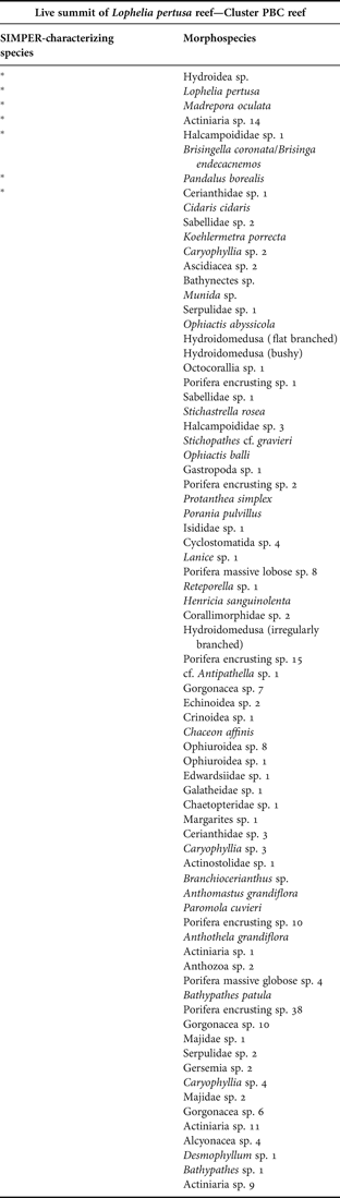
Dead framework slopes of Lophelia pertusa reef—Cluster RHF reef
This grouping contained 4 images. Analysis of this cluster using the SIMPER routine in PRIMER 6 (Clarke & Warwick, Reference Clarke and Warwick2001) revealed the average similarity within this group to be 35.07%. SIMPER analysis identified this assemblage as characterized by halcampid anemones (Halcampoididae msp. 1), serpulid polychaetes (Serpulidae msp. 1, Serpulidae msp. 2), encrusting white and yellow encrusting sponges (Porifera encrusting msp. 1 and Porifera encrusting msp. 10), cup corals (Caryophyllia msp. 2,), and ascidians (Ascidiacea msp. 2). Analysis of the environmental parameters associated with this assemblage suggests it is associated with coral rubble, and occurs at temperatures of 7 to 8°C (mean 7.9°C SD 0.2°C), and depths of 772–822 m (mean 798 m SD 28 m). This assemblage was observed on Hatton Bank.

Lophelia pertusa reef rubble apron—RBB reef
This grouping contained 19 images. Analysis of this cluster using the SIMPER routine in PRIMER 6 (Clarke & Warwick, Reference Clarke and Warwick2001) revealed the average similarity within this group to be 30.23%. SIMPER analysis identified this assemblage as characterized by squat lobsters (Munida mspp.) and ascidians (Ascidiacea msp. 2). Analysis of the environmental parameters associated with this assemblage suggest it is found on coral rubble, at temperatures between 6 and 12°C (mean 9.5°C SD 1.52°C), and at depths of 307–825 m (mean 524 m SD 175 m). This assemblage was observed in the South-West Canyons, Hatton Bank, and the shallow summit of the Wyville-Thomson Ridge.

Trawl damaged Lophelia pertusa rubble—Cluster RHE reef
This grouping contained 5 images. Analysis of this cluster using the SIMPER routine in PRIMER 6 (Clarke & Warwick, Reference Clarke and Warwick2001) revealed the average similarity within this group to be 36.66%. SIMPER analysis identified this assemblage as characterized by ophiuroids (Ophiactis balli) and serpulid polychaetes (Serpulidae msp. 1). Analysis of the environmental parameters associated with this assemblage suggests it is associated with mixed substrates of sand and coral rubble, at 11°C (mean 11.27°C SD 0.13°C), and 305–365 m depth (mean 351 m SD 26 m). This assemblage was observed from the South-West Canyons.

Highly sediment draped scattered coral framework—Cluster PBA
This cluster contained 12 images. Analysis of this cluster using the SIMPER routine in PRIMER 6 (Clarke & Warwick, Reference Clarke and Warwick2001) revealed the average similarity within this group to be 30.75%. SIMPER analysis identified this assemblage as characterized by ophiuroids (Ophiuroidea msp. 1) and cerianthid anemones (Cerianthidae msp. 1). Analysis of the environmental parameters associated with this assemblage suggests it is associated with sand substrates with biogenic gravel (coral rubble), at temperatures of 7–10°C (mean 8.65°C SD 0.89°C), and depths of 519–942 m (mean 812 m SD 141 m). This assemblage was primarily observed in the South-West Canyons, and on Hatton Bank.

Boreal ostur—Cluster RHG
This cluster contained 113 images. Analysis of this cluster using the SIMPER routine in PRIMER 6 (Clarke & Warwick, Reference Clarke and Warwick2001) revealed the average similarity within this group to be 25.27%. SIMPER analysis identified this assemblage as characterized by white encrusting sponge (Porifera encrusting msp. 1), squat lobsters (Munida mspp.), brachiopods (Brachiopoda), ophiuroids (Ophiactis balli, Ophiuroidea msp. 6), yellow encrusting sponge (Porifera encrusting msp. 12), massive lobose sponge (Porifera massive lobose msp. 12), serpulid polychaetes (Serpulidae msp. 1), green encrusting sponge (Porifera encrusting msp. 25), orange encrusting sponge (Porifera encrusting msp. 3), cream encrusting sponge (Porifera encrusting msp. 27). Analysis of the environmental parameters associated with this assemblage suggests it is associated with coarse mixed substrates of pebble, cobble and gravel (including biogenic), occurs at temperatures of 0 to 10°C (mean 7.91°C SD 1.55°C), and depths of 343–867 (mean 486 m SD 62 m). This assemblage was primarily observed from the Faroe–Shetland Channel and the Wyville-Thomson Ridge, with 2 observations from Hatton Bank and three from Rosemary Bank Seamount.